Research Articles

Spatiotemporal features of farmland scaling and the mechanisms that underlie these changes within the Three Gorges Reservoir Area

  • LIANG Xinyuan , 1 ,
  • LI Yangbing , 1, 2, *
Expand
  • 1. School of Geography and Tourism, Chongqing Normal University, Chongqing 401331, China
  • 2. Key Laboratory of Surface Process and Environment Remote Sensing in the Three Gorges Reservoir Area, Chongqing 401331, China
*Corresponding author: Li Yangbing (1968-), PhD and Professor, specialized in land use and ecological process. E-mail:

Author: Liang Xinyuan (1996-), Master, specialized in soil and water conservation and land use. E-mail:

Received date: 2018-06-14

  Accepted date: 2018-08-18

  Online published: 2019-04-12

Supported by

Key Basic Science and Cutting Edge Technology Research Plan of Chongqing, No.cstc2015jcyjBX0128

National Natural Science Foundation of China, No.41261045

Chongqing Normal University Graduate Student Research Innovation Project, No.YKC18033

Copyright

Journal of Geographical Sciences, All Rights Reserved

Abstract

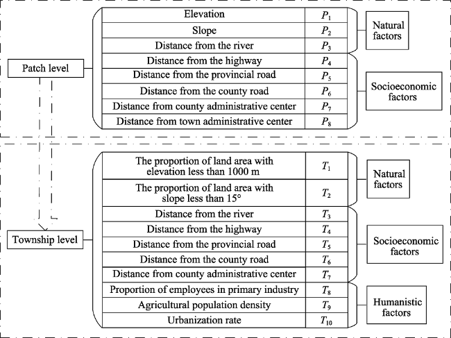
Discussions regarding the functional transformation of agricultural utilization and the mechanisms that underlie these changes within the Three Gorges Reservoir Area (TGRA) reflect variations in the relationship between people and their environment in China’s central and westerns part, an area of mountains and reservoirs. A clear understanding of these changes also provides the scientific basis for the development of multi-functional agriculture in typical mountainous areas. Five counties were selected for analysis in this study from the hinterland of the TGRA; we analyzed changes in farmland scaling and corresponding underlying mechanisms by defining the concepts of “Scaling Farmland” (SF) and by using the software packages ArcGIS10.2, SPSS, and Geographical Detectors. The results of this analysis show that sources of increased SF have mainly comprised cultivated and shrub land. Indeed, with the exception of some alpine off-season vegetables, SF growth has mainly occurred in low altitude areas and in places where the slope is less than 30°. We also show that spatial changes in various SF types have also been substantially different, but in all cases are closely related to road and township administrative centers. Natural factors at the patch level, including elevation and slope, have contributed significantly to SF, while at the township level, underlying socioeconomic and humanistic factors have tended to include road traffic and agricultural population density. In contrast, at the regional level, underlying driving forces within each have tended to be more significant than overall study area scale. We show that while changes in, and the development of, SF have been driven by numerous factors, agricultural policies have always been amongst the most important. The results clearly elucidate general land use transformation patterns within the mountain regions of western China.

Cite this article

LIANG Xinyuan , LI Yangbing . Spatiotemporal features of farmland scaling and the mechanisms that underlie these changes within the Three Gorges Reservoir Area[J]. Journal of Geographical Sciences, 2019 , 29(4) : 563 -580 . DOI: 10.1007/s11442-019-1615-0

1 Introduction

As human societies have developed over time, land use has also tended to undergo transitions from prehistoric forests and other natural ecosystems through the various stages of territory reclamation, livelihood-based agriculture, gradual intensification, and almost complete utilization (Defries et al., 2004; Foley, 2005). Land use intensification is an inevitable choice for humans given the multiple pressures of food security, economic development, and ecological protection (Lambin and Meyfroidt, 2011). This means that in order to guarantee human survival, cultivated land is likely to have also experienced a shift from rapid reduction, fragmentation and quality degradation through to stabilization, growth recovery, intensification, and multi-functionality (Liu et al., 2014).
In order to achieve agricultural modernization, countries around the world have gradually come to the realization that the fragmented management of rural land acts as an unfavorable factor that holds back agricultural development (Dai et al., 2015; Dong and Tang, 2015). Low agricultural output efficiency values in such situations have tended to compel governments to take economic or political measures to promote the large-scale operation of agricultural land. The development of farmland scale management therefore depends on levels of local economic development (Driscoll and Kraay, 1998); the concept of “Scaling Farmland”(SF) can therefore be regarded as the inevitable result of farmland scale management. At the same time, however, current research on large-scale farmland areas tends to be mainly focused on management types, their appropriateness, and the relationship between labor force and productivity (Tang and Zeng, 2014).
Current agricultural land scale within China falls far below the optimal per capita operational level. This means that agricultural land concentration is an important variable that can be assessed to improve labor productivity (Abro et al., 2014). At the same time, significant regional and individual differences are also seen in farmland scale management willingness (Niroula and Thapa, 2005); the suitable land management scale for single farmer households in the municipality of Chongqing, for example, falls between 0.33 ha and 1.19 ha, and the functional solution for measuring the appropriate size of a single land parcel is 0.90 ha (Yang et al., 2009). A number of relevant studies in this field have suggested that farmland scale is a common indicator of socioeconomic changes in rural areas, while varying national or local farming systems as well as policies and legislative changes can all lead to different interpretations of this concept (Moran, 1997). Agricultural land size expansion is therefore a key variable that should be taken into account to mitigate farmland abandonment and increase incomes (Tan et al., 2013). In this context, market competitiveness in terms of the agricultural value chain (Dannenberg and Kuemmerle, 2010) as well as policies and the labor force will all exert differential impacts on the scale and expansion of this land use type (Bartolini and Viaggi, 2013). Agricultural environmental measures will also lead to variation in farmland across different scales (İlkay and Štefan, 2015). All of these factors mean that SF distribution and change can be used to guide the direction of regional agricultural development, while the heterogeneity of regional conditions will also cause differential evolution of this variable. Existing research in this area has mainly focused on the function and impact mechanisms of farmland scale management; few analyses of SF spatiotemporal characteristics have been performed within typical regions.
Growth in SF influences regional agricultural vitality, technological change, and the development of commercialization in different ways (Jayne et al., 2011). At the same time, land yield increases across China have also been closely related to the growth of this variable (Wang et al., 2015); this means that assessments of cultivated land natural conditions and the spatial resource endowments of small-scale areas can be used to overcome the shortcomings inherent to the disjunction between current research on land scale operations and geographical space. These approaches also provide the basis for a region to properly undertake appropriate scale operations and determine the intensive utilization of production space (Long et al., 2010). The hinterland of the Three Gorges Reservoir Area (TGRA) is defined as the Three Gorges resettlement area and is ecologically vulnerable (Meng et al., 2010); this region is dominated by mountains and hills and so farming conditions are harsh. Impoundment of the Three Gorges Dam also inundated large land areas within this region and had a significant impact on the development of agriculture and the rural economy. This has led to a sharp decline in cultivated land resources and an increase in non-agricultural construction land; as these trends have been unbalanced, conversion of land use types within the reservoir area has been promoted and has further exacerbated contradictions between humans and natural resources (Shao et al., 2018). These factors have also created new opportunities for the intensive use of land resources within the TGRA. The concept of “Scaling Farmland” (SF) is therefore defined in this study as typical of cultivated land functional transformation. Agricultural land use within the TGRA is then used as an example to discuss spatiotemporal changes and the driving forces underlying SF given the influence of various factors subsequent to impoundment of the Three Gorges Dam. The overarching goal of this analysis is to determine the nature of the changes seen in rural areas as well as the relationship between people and the environment in central and western regions, mountainous areas, and the TGRA. The results of this study therefore provide a clear scientific basis that can be used to guide the direction of agricultural development and multi-functional transformation in the mountainous areas of China.

2 Study area

The study area for this research is located in the center of the TGRA and encompasses a total area of approximately 18,729 km2 (Figure 1). This zone occupies more than half of the ecological conservation area of northeastern Chongqing, and includes the central and western regions of the Yangtze River Basin as well as the junction between three major regions of southwestern, northwestern, and central China. The sites selected for study comprise five districts and counties, namely, Kaizhou District as well as Wushan, Yunyang, Fengjie, and Wuxi counties, all of which exhibit significant differences in their levels of economic development. Terrain trends within the study area range from high in the northeast to low in the southwest, and encompass a complex set of conditions and various landform types. Climate across the study area is subtropical and humid monsoonal and includes extensive forest land coverage, severe sloping farmland reclamation, and fragile ecological environments. This region is characterized by the most serious levels of water and soil loss within the TGRA.
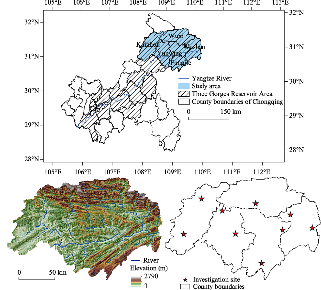
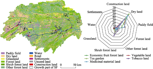
Figure 1 Location, topography, and spatial distribution of sites studied in the Three Gorges Reservoir Area

3 Materials and methods

3.1 Definition and identification of scaling farmland

Farmers have tended to adjust planting directions in light of land use transformations both to meet their own economic needs and to organize the agricultural land consolidation so that usage can be scale intensive (Petit et al., 2011); this phenomenon illustrates the SF transition of traditional farmland. We therefore defined the concept of SF both internally and externally by referring to the qualitative expression of the concept of “agricultural system transition” (Amjath-Babu and Kaechele, 2015). In this context, externality implies the presence of a perfect road system and complete infrastructure within a cultivated area; the dominant crops planted in such a region will therefore be non-food varieties with higher economic utility, and their layout will be arranged neatly with obvious traces of artificial planning. The opposite, internality, is therefore embodied by intensive agricultural land use that is distinct from conventional intensive utilization and is mainly driven by economic profit differentiation factors such as the economic behavior of farmers (or enterprises) and ecological construction policies put in place to promote the transformation of traditional agricultural land into multi-functional “Economic Ecotypes”. This form of land use meets the requirements of modern agricultural construction (Table 1).
Table 1 SF identification standards
In this context, SF scale is mainly determined on the basis of relevant research regarding the moderate-scale management of domestic farmland and family farms both within China and around the world (Yang et al., 2016). It has proved difficult, however, to implement farmland consolidation within the TGRA because of complex terrain conditions and a low level of agricultural mechanization, especially in mountainous areas. The main SF component within this region has also tended to become more diversified, including the dominant behavior of farmer households, enterprises, and the government. An area of 2 ha was therefore used here as the basic SF standard via field inspections (Xu and Yin, 2010), while 0.47 ha was utilized for the scale of this variable given the behavior of farmers in accordance with the optimum scale of family farm, as suggested by Herdt and Mandac (1981). In light of the time attributes inherent to the agglomeration characteristics of SF as well as remote sensing (RS) data resolution, a series of subjective interpretations were therefore performed based on the proximity and aggregation trends of fragmentized patches at the landscape level via human-computer interactions. Thus, SF patches with areas less than 0.47 ha accounted for 15.84% and 12.45% of the total were used in 2009 and 2016, respectively. Errors due to individual subjective behaviors in judging agglomerations remained negligible in this analysis due to their small proportions. These approaches mean that SF comprises a multi-functional agricultural set of large-scale non-grain crops that either exhibit agglomeration trends or have been used intensively by farmers, enterprises, or government under the influence of economic behaviors and ecological policies.

3.2 Data sources

The spatial data utilized here includes RS images captured by the Chongqing Quick Bird satellite in 2016; these images have a 0.51 m resolution while those captured by the China-Brazil Earth Resources satellite have a resolution of 2.5 m across the TGRA hinterland and were captured in 2009. Our acquisition of township-level administrative divisions was mainly based on the adjustments of these categories within districts and counties in recent years, including a total of 165 comprising townships as well as towns and streets. The statistical data used in this study were extracted from the 2015 China County Statistical Yearbook (Township Volume) as well as the 2016 statistical yearbook for each district and county.
We divided SF into five categories for analysis including economic fruit forest land, vegetable land, tea gardens, tobacco land, and medicinal material land (Figure 2) based on the GDPJ01-2013 Geographical National Conditions Survey Contents and Indicators. Thus, on the basis of the interpretation marks established in our field survey (Figure 1), SF vector patches were obtained using the software ArcGIS10.2 and used to interpret RS images via human-computer interactions. Interpretation accuracies for the five SF types were 96.1%, 93.5%, 89.7%, 91.4%, and 87.7% after field verification, respectively.
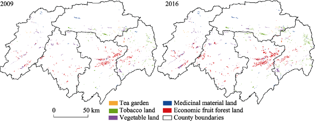
Figure 2 The spatial distribution of various SF types in the Three Gorges Reservoir Area in 2009 and 2016

3.3 Research methods

3.3.1 Indicator selection
A complete indicator system was established for this analysis based on related research (Guo et al., 2015; Su et al., 2016), encompassing nature, socioeconomic, and humanity-based factors to reveal the underlying factors influencing SF growth. These factors were analyzed in detail at both patch and township levels (Figure 3); eight indicators were selected as explanatory variables at the patch level, while ten were selected at the township level. Demographic data including urbanization rates have often been analyzed as socioeconomic factors in previous land-use related studies; however, since the mutual relationship between population levels and economic distribution within the TGRA is constantly changing geospatially (Zhou et al., 2011) due to the influence of mountainous location conditions and the special nature of resettlement projects, population-related data were summarized as humanistic factors in this analysis. All indicator data attributes were therefore considered to be continuous raster types for this study and were re-sampled at a resolution of 500 m to create a Geographic Information System (GIS) database. Combined with the actual scope of the study area after repeated simulations, a resolution of 500 m accurately reflects the essential characteristics of most dependent variables.
Figure 3 SF driving index
3.3.2 Multiple logistic regression model
A logistic model is a regression expression established on the basis of two, or more, response variable categories such that independent variables can either be qualitative or quantitative data hypotheses. An increase (or not) in SF was considered here as two variables, and a binary logistic regression model was utilized (Wu et al., 2010), as follows:
$f(x)=\frac{{{e}^{x}}}{1+{{e}^{x}}}$ (1)
Thus, according to the definition of the expected discrete random variable value, p was used to represent the probability y = 1 while the independent variable was x. It therefore follows that:
$f(p)=\frac{{{e}^{p}}}{1+{{e}^{p}}}=\frac{{{e}^{(a+{{b}_{1}}{{x}_{1}}+{{b}_{2}}{{x}_{2}}+\cdots +{{b}_{n}}{{x}_{n}})}}}{1+{{e}^{(a+{{b}_{1}}{{x}_{1}}+{{b}_{2}}{{x}_{2}}+\cdots +{{b}_{n}}{{x}_{n}})}}}$ (2)
As change in the function f(p) for x is insensitive and slow in the vicinity of f(p) = 0 or f(p) = 1, and the degree of nonlinearity is high, a logistic transformation of f(p) can be introduced, as follows:
$\log \ it(p)=log(p/1-p)=a+{{b}_{1}}{{x}_{1}}+{{b}_{2}}{{x}_{2}}+\cdots +{{b}_{n}}{{x}_{n}}$ (3)
The probability of p can therefore be calculated, as follows:
$p=\frac{{{e}^{(a+{{b}_{1}}{{x}_{1}}+{{b}_{2}}{{x}_{2}}+\cdots +{{b}_{n}}{{x}_{n}})}}}{1+{{e}^{(a+{{b}_{1}}{{x}_{1}}+{{b}_{2}}{{x}_{2}}+\cdots +{{b}_{n}}{{x}_{n}})}}}$ (4)
Analyzing the natural and economic factors influencing the growth of the five SF types considered in this study (i.e., economic fruit forest land, vegetable land, tea gardens, tobacco land, and medicinal material land), a series of primary and secondary relationships were determined according to the contribution of each to overall growth. The purpose of this analysis was to predict the probability of SF growth in each case based on impact factors corresponding to patch and township.
3.3.3 Geo-detector implementation
The spatial distributions of geographic entities and phenomena are influenced by a variety of natural and socioeconomic factors. This means that an analysis of formation mechanisms is of considerable significance if we are to determine the spatial distribution characteristics that underlie geographic phenomena (Wang et al., 2016). The use of a geo-detector in this context was proposed by Wang and Hu (2012) on the basis of spatial superposition technology and set theory, as follows:
${{P}_{D,H}}=1-\frac{1}{N'\sigma _{H}^{2}}\sum\limits_{w=1}^{m}{{{n}_{D,w}}\sigma _{{{H}_{D,w}}}^{2}}$ (5)
In this expression, PD,H denotes the influence of an impact factor on newly-increased SF, while$\sigma _{{{H}_{{}}}}^{2}$refers to variance in the number of newly-increased SF across the entire region, $\sigma _{{{H}_{D,w}}}^{2}$ is the variance in this factor in a second-level region w, and N' is the number of samples (i.e., N’ = 165). Thus, nD,w denotes the number of samples in the second-level region w, and m is the number of second-level regions (i.e., the number of influential factors in natural clustering and zoning, 0 ≤ w m); this means that when 0 ≤ PD,H ≤ 1 and PD,H = 0, the spatial distribution of newly-increased SF is not driven by a particular impact factor. In other words, the greater the value of PD,H, the greater the influence of zoning factors on newly-increased SF; this variable can therefore be used to explain the spatial differentiation characteristics of newly-increased SF with a higher degree of confidence.
A geo-detector algorithm for categorical data is superior to one for continuous data (Wang et al., 2010), and so K-means clustering of continuity detection factors was initially performed using the software SPSS, divided into 1, 2, 3, 4, 5, 6, and 7 categories. All the factors we used were based on 2016 status data, and there is no corresponding relationship between their level of clustering and the actual influence of detection in each case. The spatial distribution of each detector category is illustrated in Figure 4, and a-j correspond to the township level influencing factors T1-T10.
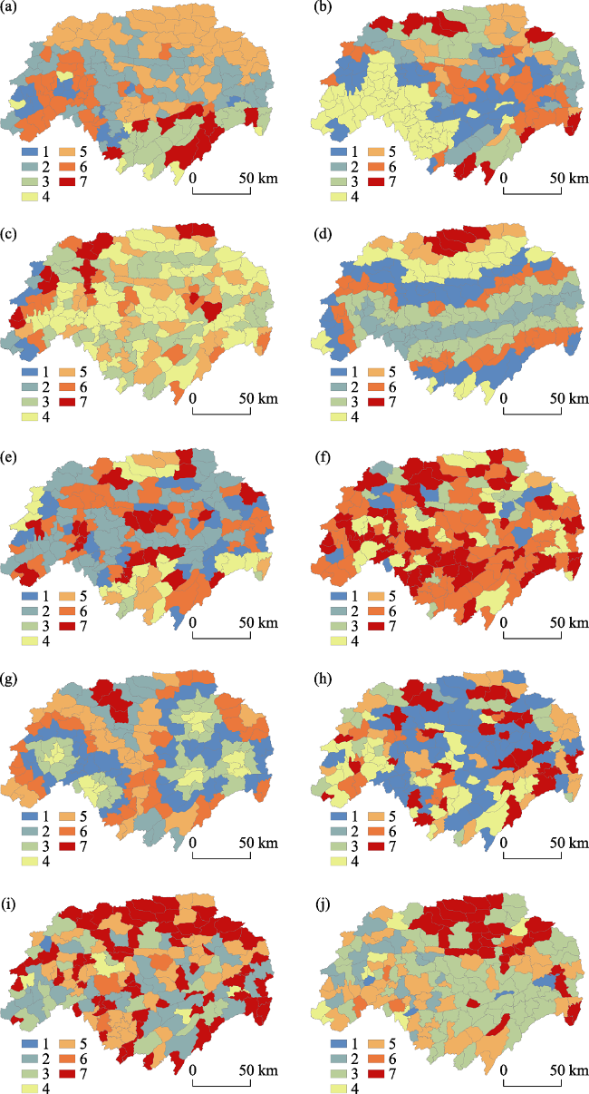
Figure 4 The spatial distribution of classified geographic detection factors in the Three Gorges Reservoir Area

4 Results and analysis

4.1 SF spatiotemporal variation

4.1.1 SF temporal changes
The data collated here reveal that the main types of land use within the study area in 2009 comprised forested and cultivated land (Figure 5). Results show that SF growth between 2009 and 2016 was basically derived from dry land and paddy fields, and that the transfer volume from other land types to SF remained very small. The main transfer sources gener- ating economic fruit forest land comprised dry land (61.67%) and paddy fields (16.76%). As a crop planted in either dry or irrigated land, scaling processes leading to vegetable land comprised either transfer of the dry land (44.07%) or paddy fields (27.34%), while the main source of tea gardens was also from dry land (64.12%) and the total amount of shrub land transfer increased to 17.85%. Tobacco land is also a dryland crop and transfer into this type mainly comprised shrub land (25.37%) with the exception of a large proportion of dry land (41.79%), while the main transfer sources for medicinal material land were dryland (57.74%) and paddy fields (26.01%).
Figure 5 Land use types in 2009 and sources of SF in the Three Gorges Reservoir Area in 2016
4.1.2 Spatial SF change processes
The results presented in Figure 6 reveal spatial changes in SF growth. These data show that growth in economic fruit forest land over the time period of this analysis was mainly concentrated in areas with elevations less than 800 m and slopes between 15° and 25°. Growth in this land use type is negatively related to distances from rivers and highways as well as county and provincial roads; indeed, economic fruit forest land area increased at a uniform rate within a range of 10 km to administrative town centers.
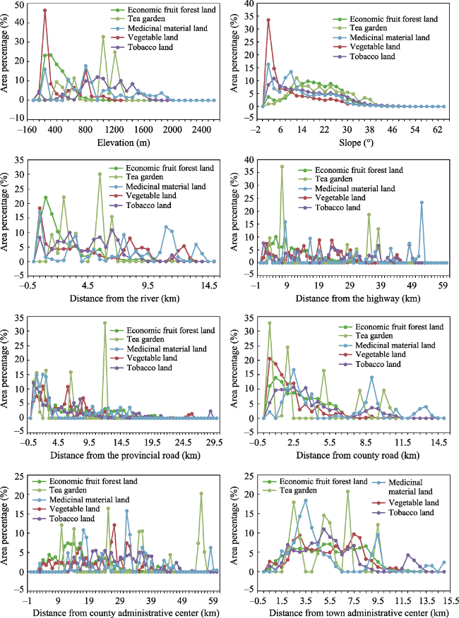
Figure 6 Spatial variations in SF across the Three Gorges Reservoir Area
(The area percentage shown here represents the ratio of SF area change while the buffers account for total SF area change throughout the study period)
Growth in vegetable land has been mainly concentrated in areas at elevations less than 800 m, and mostly within a range of slopes less than 10°; this relationship is significantly negatively correlated with slope. As this industry is market-oriented, the resource integration process of economic fruit forests and vegetables has generally tended to be concentrated in township regions and the transition from low-level to high-level markets has gradually been achieved via a “bottom-up” market-oriented law.
Data show that the growth of tea gardens across the study area has mainly been distributed within a range of elevations between 400 m and 1200 m, slopes between 10° and 32°, and at distances between 2 km and 10 km from town administrative centers. Maximum values in this case were attained at 6 km distances from rivers and 7 km distances from highways; indeed, tea garden growth has tended to exhibit jumps in concert with increasing distances from provincial roads while the opposite has been seen with respect to county roads. These trends suggest that the production and marketing of tea in regions has mainly been focused on district and county units, although a holistic distribution pattern was not clear due to the small sample size of this study.
Growth in tobacco land across the study area has mainly been distributed within a range of elevations between 400 m and 1,600 m, distances from rivers less than 8 km, and slopes less than 32°; the distribution ratio in this case is negatively correlated with increasing slope as well as distance from provincial and county roads. Data show that growth in tobacco land has been evenly distributed within a range between 13 km and 9 km from county adminis-trative centers; changes in this land use type have conformed to a trend of initial increase followed by subsequent decrease with distance from town administrative centers.
Growth in medicinal material land has tended to be distributed within areas with elevations less than 2,000 m. Data show that this land use type initially increased and then decreased in regions with slopes less than 30° and have tended to be concentrated at distances less than 4 km from provincial roads. Changes in this land use type have also tended to initially increase and then decrease with distance from town administrative centers. As tobacco and medicinal materials both have high requirements for soil quality and are labor-oriented industries, underlying change laws have tended to be basically the same.

4.2 Factors underlying changes in various SF types

We utilized values of the Wald statistic output by the software SPSS as estimates for the regression coefficient. These indicate the relative weight of each explanatory variable in our model and can be used to evaluate the contribution of each to event prediction (Rgjr and Schneider, 2001). Data show that the most important factor influencing SF growth at the patch level (Figure 7) was P2 (slope) in all cases apart from economic fruit forest land. This is because the cultivation of economic fruit forests is generally carried out in low-altitude areas as this facilitates both planting and harvesting. Indeed, in order to improve water efficiency and control soil erosion, economic fruit forests also tend to be planted across large areas and encompass a wide range of slopes, while sources for vegetable land are dominated by areas with low slopes, including cultivated land. Tea gardens tend to be distributed on steep slopes and spatial structures similar to terraces for easy management. The law underlying the placement of tobacco and medicinal material land are also basically the same, as these types tend to be distributed on flat terrain with low slopes. The overall results of this analysis show that the contribution of all factors apart from slope are unobvious; the forces driving of natural factors were high when farmers grew SF, especially when harvest and efficiency issues were taken into account. Most farmers do not attach importance to distance to market or the convenience of transportation.
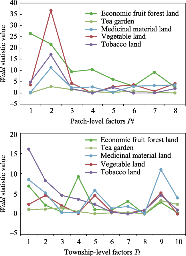
Figure 7 Values for the Wald statistic at different levels
The average contribution of township-level factors relative to patch level was slightly higher throughout the scope of this analysis, and all SF variables tended to be close to highways, provincial roads, and other regional connecting channels. This result shows that decision makers at this level pay more attention to the convenience of communicating with markets although natural variables still make a high relative contribution. Humanistic factors, such as agricultural population density, also exert a significant influence on tea garden and medicinal material land SF, related to the amount of labor demand. Data show that the development of SF from the perspective of farmers has tended to emphasize the advantages and disadvantages of natural planting conditions to a greater extent in order to achieve individual economic development. Decision makers at the township level plan the overall allocation of labor resources and infrastructure construction via government regulations and supplement the needs of local economic development via SF benefits while at the same time promoting its development.

4.3 Factors driving SF changes across the study area

Values for PD,H that reflect the ability of each detection factor Ti (i.e., identical to township-level influencing factors) affecting the SF growth process were calculated using a geo-detector (Figure 8 and Table 2). Results show that the influence of each detection factor on the entire scope of the study area remained extremely weak while at the same time exerting a strong influence on low-level space evaluation units (districts and counties).
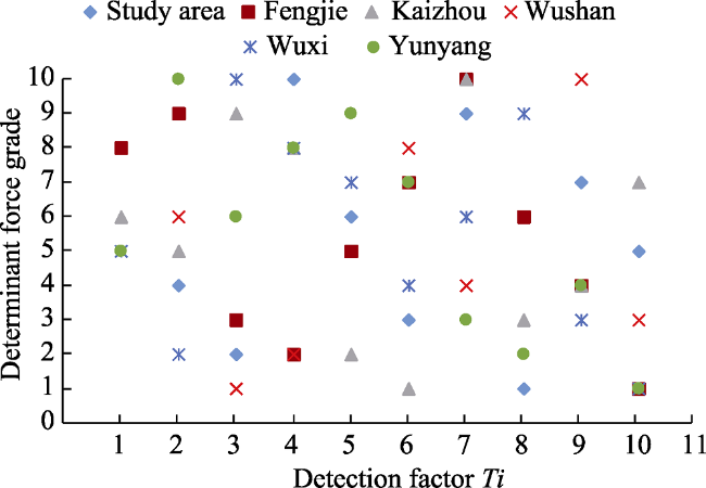
Figure 8 Detection factor determination levels
Table 2 Influence of detection factors
Detection factors Study area Fengjie Kaizhou Wushan Wuxi Yunyang
T1 0.05 0.25 0.14 0.14 0.13 0.11
T2 0.03 0.28 0.14 0.18 0.01 0.39
T3 0.02 0.12 0.22 0.06 0.49 0.16
T4 0.07 0.11 0.17 0.08 0.28 0.24
T5 0.03 0.17 0.06 0.20 0.26 0.35
T6 0.02 0.17 0.04 0.23 0.09 0.20
T7 0.05 0.32 0.26 0.10 0.21 0.09
T8 0.01 0.17 0.07 0.25 0.34 0.08
T9 0.04 0.15 0.09 0.35 0.08 0.09
T10 0.03 0.02 0.15 0.09 0.01 0.05
(1) Results for Fengjie County reveal that this area has been vigorously developing a navel orange industry in recent years, and so the direction of production and marketing has generally been headed at the county level and has subsequently expanded outwards. The development of this industry is therefore closely related to the distance from county centers and roads. The major SF in Fengjie County was economic fruit forest land, and the complexity of planting conditions led to a strong dependence on natural factors.
(2) The growth of SF in Kaizhou District was reliant on the distance from the county center and the river because of the vigorous development of the vegetable industry. Increases in the urbanization rate were accompanied by improvements in quality of life which themselves promoted SF development.
(3) Changes in SF in Wushan County were dominated by tobacco land for which planting conditions are highly dependent on labor. These changes are therefore closely related to humanistic factors including agricultural population density while convenient transportation satisfied the living requirements of the labor force.
(4) Wuxi County has tended to lag behind the rest of the study area in terms of economic development, with relative disadvantages in terms of both infrastructure construction and natural conditions. The total amount of SF was the smallest in this case and remains at a development stage; and most of them rely on rivers and other water source conditions, close to roads and county centers.
(5) Growth in SF within Yunyang County reveals a reduction in the force of humanistic factors. The SF planting type in this region is dominated by economic fruit forest land. As an important hub of the economic corridor along the Yangtze River within the TGRA, SF growth in Yunyang County is closely related to highways and roads.

5 Discussion

5.1 The significance of SF distribution and changes

The distribution of SF values basically extends from the bank of the Yangtze River to north and south in an axial direction, mainly in flat areas along the river valley. Data show that vegetable land tends to be distributed at slopes less than 10°, while economic fruit forest land and tea gardens are mainly distributed in areas with slopes between 10° and 30°, and tobacco land and medicinal material land are distributed on land with slopes less than 30°. The results of this analysis show that all SF types are concentrated on land with elevations less than 1500 m; indeed, most SF tends to have enhanced requirements for suitable altitude with the exception of a few crops requiring alpine cultivation environments. The type of SF across the field area tends to be dominated by economic fruit forest land close to roads and town administrative centers; this result indicates that development has gradually catered to the orientation of the market economy and has shifted from a single food supply function to modern multi-functional farmland. The formation of SF, including economic fruit forest land and tea gardens, will help improve soil conditions and ecological functions.
The results of our field surveys indicate that the development of SF, especially economic fruit forests, is based on intensive land use as a means to improve economic and ecological benefits. The transformation of most forest land to SF has therefore conformed to the principle of “using economic fruit forest instead”, replacing former shrub land with economic fruit forests to increase economic efficiency while ensuring ecological benefits. Orchard development, however, does not fully guarantee regional ecological security; farmers clear grass and shrubs within economic fruit forest planting areas to render trees more intensive and to ensure economic benefits, a process which results in a large area of land exposure and affecting the ecological benefits of planted regions. Intercropping is therefore necessary to improve regional ecological benefits. Cultivated land functional transformation (Figure 9) has therefore promoted SF formation while the intensive planting conditions have improved the status of sloping farmland and reduced ecological risks. The distribution and changes in SF therefore represent farmland transitions, especially sloping land; the evolution of sloping farmland is closely related to the development of economic fruit forests while SF changes have determined the direction of regional agricultural transformation. This has provided guarantees for the sustainable development of modern agriculture and ecological security across the study area.
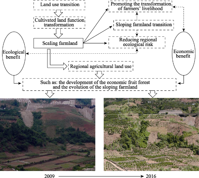
Figure 9 Regional agricultural land use transformations

5.2 Mechanisms driving policy responses to SF change

In earlier work, You (2017) discussed the process of exploring dynamic changes in the agri- cultural landscape within Ningbo City, which revealed that economic transformations have influenced the agricultural landscape by influencing changes in land use patterns. Liu et al. (2016) had earlier shown that the changes in crop types and their spatial distribution within Zhangye City were mainly due to the advancement of economic development and urbanization. The development focus of SF will therefore differ at various stages of socioeconomic development. Our data show that the proportion of SF across our study area ranges from the largest-to-smallest in the order of Fengjie, Kaizhou, Wushan, Yunyang, and Wuxi; these subdivisions basically conform to the economic development level of each district and county.
Although SF is closely related to the level of socioeconomic development, it remains constrained by numerous other factors. At the patch level, individual interests of farmers are the main factors; at the township level, development direction of local government is the goal; while at the regional overall level, SF development is guided by national policies. SF development space generally tends occur in planting environments with superior natural conditions from the perspective of farmer households, while the role of natural and socioeconomic factors is slightly stronger than humanistic factors. Local governments promote the development of SF and effective agriculture enables the development of national policies which pay attention to the economic and ecological benefits of cultivated land transitions. The influences of socioeconomic and humanistic factors are therefore stronger than natural ones and the relationship between various drivers is complementary (Figure 10).
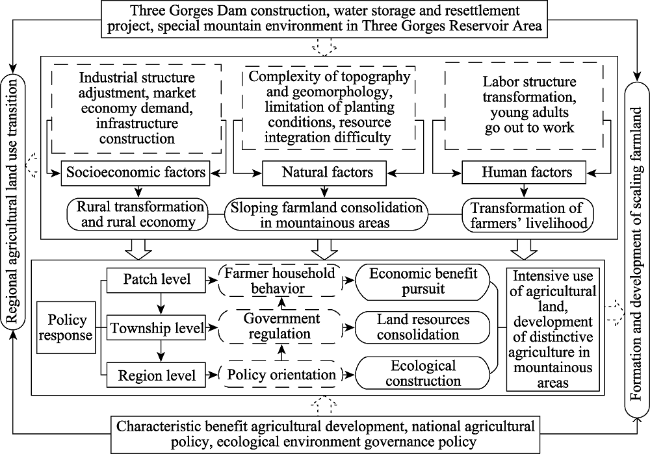
Figure 10 The mechanisms driving policy responses to SF change
Implementation of Three Gorges Dam construction, water storage, and resettlement projects have successively enabled the economy to develop rapidly within the TGRA. Social changes under the market economic system, such as industrial restructuring and infrastruc- ture construction, have accelerated the transformation of rural areas, while the massive movement of young laborers has also transformed the livelihoods of rural households. Additional factors such as the complex topography of mountainous terrain and the difficulty to integrate agricultural resources due to natural conditions have all promoted the intensive use of land in mountainous rural areas. The development of SF within the TGRA occurs at the intersection of the sloping farmland transition and policy requirements such as ecological governance in the mountainous rural areas. Varying levels of behavioral agents will therefore interact to promote the development of SF in different directions, but generally these are affected by the status of national agricultural development and government policy guidance. The effectiveness of policy tools must therefore address the complexities of ecology, economy, and society, as well as the personal decisions of local actors that lead to institutional change (Grashof-Bokdam et al., 2016). Agricultural policies will affect the focus of each driver; thus, discussion of the evolution of SF within the TGRA will help to ascertain the influence of various driving factors and aid decision makers to propose reasonable development policies for agricultural development under different environmental conditions.

6 Conclusions

The concept of SF is presented in this paper. Data reveal the processes of cultivated land functional transformation via analysis of the development and evolution of SF within the TGRA. Results show that:
(1) The distribution of SF values basically extends from the bank of the Yangtze River to the north and south in an axial direction, mainly in flat areas along the river valley. SF are concentrated on land with elevations less than 1500 m and slopes less than 30°; most SF tends to have enhanced requirements for suitable altitude with the exception of a few crops requiring alpine cultivation environments. The proportion of SF across our study area ranges from largest-to-smallest in the order Fengjie, Kaizhou, Wushan, Yunyang, and Wuxi; these subdivisions basically conform to the economic level of each district and county.
(2) SF represents the multi-functional development level of cultivated land utilization within this area, and large-scale exploitation of the economic fruit forest type in SF revealed the use patterns and ecological implications of the sloping farmland in the TGRA. This result therefore indicates that the direction of cultivated land functional transformation in the TGRA will continue to emphasize the win-win of economic and ecological functions. The functional transformation of cultivated land use in the TGRA conforms with Chinese agricultural social and ecological economic development policies and promotes the formation and development of SF. Changes in the spatiotemporal distribution of SF indirectly reflects the fact that future development trends will be oriented to meet market demand. The results of this study therefore elucidate general patterns in land use transformation in mountainous regions of western China.
(3) Our analysis of driving mechanisms at different scale levels reveals that natural factors contributed most to the growth of SF at the patch level, while at the township level, these changes were mainly driven by socioeconomic and humanistic factors. In contrast, at the regional level, driving factors of districts and counties were more significant than overall factors and were closely related to the direction of agricultural development such that each county combined its own development advantages with government policies. Analysis of these factors across three scales shows that there are certain intrinsic links that connect the individual behaviors of rural households, the regulation of lower-level government, and the orientation of national policies. Our ultimate goal is to develop characteristic and effective agriculture, to improve the ecological environment and the rural economy in the TGRA which will further accelerate SF formation.
(4) This study has a number of deficiencies, including the fact that SF is one product of cultivated land functional transformation. The true meaning of this variable is therefore not limited to just the five standards defined in this analysis, but also encompasses other multi-functional agricultural parks such as leisure and sightseeing agriculture. In order to facilitate analysis and expression, SF was nevertheless classified according to planting types in this analysis; we believe that the results of this study objectively reflect the status quo of agricultural functional transition across the TGRA study area.

The authors have declared that no competing interests exist.

[1]
Abro Z A, Alemu B A, Hanjra M A, 2014. Policies for agricultural productivity growth and poverty reduction in rural Ethiopia.World Development, 59(3): 461-474.Increasing the productivity of smallholder agriculture holds the key to poverty reduction. The empirical literature is limited to ascertain the linkages and the implications for policy uptake in Ethiopia. We examine the impact of growth in agricultural productivity on household poverty dynamics in rural Ethiopia using a panel dataset (1994–2009). Findings suggest that government policies aimed at reducing poverty should adopt a growth plus approach—designing policy interventions to support agricultural productivity growth, plus to protect assets and enhance market access for rural households in the country.

DOI

[2]
Amjath-Babu T S, Kaechele H, 2015. Agricultural system transitions in selected Indian states: What do the related indicators say about the underlying biodiversity changes and economic trade-offs?Ecological Indicators, 57: 171-181.The article describes the land use system transition dynamics in selected states in India and discusses its underlying biodiversity impacts and economic driving forces. The concept of system transition is described as a continuum between forests and highly intensive agriculture via different grades of intensification where profit differential is identified as the system transition pressure. In order to operationalise the concept, the article develops land use suitability, input use intensity and farming system diversity indices which are calculated for different agricultural cropping systems in the selected states of India. The results show the apparent decline in land use suitability, reduction in farming system diversity, increase of cultivation intensity, reflecting a reduction in planned and associated agro-biodiversity. The results also show increasing transition pressure to shift from low intensive and high diverse systems to high intensive low diverse systems that represent increasing opportunity cost of conservation of the former systems. A set of policy measures to deflate the transition pressure that can at least retain a threshold of traditional high diversity systems are briefly discussed. The study also outlines further research directions.

DOI

[3]
Bartolini F, Viaggi D, 2013. The common agricultural policy and the determinants of changes in EU farm size.Land Use Policy, 31(2): 126-135.Structural change provides the possibility of increasing the competitiveness and efficiency of the entire agricultural sector through a better allocation of productive factors. Amongst the productive factors, land is the one that most often limits farm development. This paper seeks to identify determinants of intended changes in farm size (represented by farmed area and measured as a reduction, expansion or no change) identified as stated intentions expressed through survey information, under two different Common Agricultural Policy (CAP) scenarios: (1) the Baseline, characterised by the Health Check policy as of 2009; and (2) a No-CAP scenario, assuming the elimination of all CAP payments and regulatory measures. Results highlight that CAP abolishment strongly reduces the intention to increase the amount of farmed area; the determinants of change in farmed area also change sharply amongst the two scenarios. Geographic variables, and farm characteristics such as farm organisation and the number of on-farm employees are relevant to explain the farmed area expansion. On the contrary, without the CAP, the relation between household and farm has strong effects on the different directions of change of farmed area. The results confirm that the different single payments scheme models affect the changes in demand of land.

DOI

[4]
Dai S Q, Wu B W, Wu S D,et al., 2015. Priority research of hilly land consolidation based on land fragmentation and location condition: A case study of Songxi county, Fujian province.Journal of Guizhou Normal University (Natural Sciences), 33(4): 14-20. (in Chinese)Based on the micro-perspective,this paper used administrative village and plaque as evaluation unit and constructed the"fragmentation degree and location superiority or inferiority"multi-factor evaluation system in order to explore the priority of land consolidation in hilly and mountain areas. The results indicated that: The cultivated land which was complete,flat and closed to roads,towns,rivers and inhabited villages should be consolidated preferentially. In Songxi,the priority of land consolidation was classified into 3 categories,including the short-term zone,the medium-term zone and the long-term zone,which were 58. 39% 、26. 81% and 14. 8% in the proportion of cultivated land respectively,involving 53、31 and 21 administrative villages.

[5]
Dannenberg P, Kuemmerle T, 2010. Farm size and land use pattern changes in postsocialist Poland.Professional Geographer, 62(2): 197-210.

DOI

[6]
Defries R S, Asner G P, Houghton R A, 2004. Trade-offs in land-use decisions: Towards a framework for assessing multiple ecosystem responses to land-use change.Geophysical Monograph, 153: 1-9.People alter the landscape primarily to appropriate ecosystem goods such as food, fiber, and timber for human consumption. Unintended consequences for ecosystems vary according to the type of land-use change, e.g., forest clearing for agriculture, grassland conversion for grazing, or urban expansion, as well as the underlying ecological characteristics, e.g., humid vs. dry, phosphorus vs. nitrogen-limited, or tropical vs. temperate. The ecosystem responses potentially alter future abilities to provide ecosystem goods and influence future land-use decisions. This volume addresses five major ecosystem responses to land-use change: hydrological, climatic, biogeochemical, human health, and biological diversity. The chapters summarize current knowledge from the perspectives of different disciplines and present analyses from many parts of the world in different ecological and socioeconomic settings. This introductory chapter develops a framework for understanding and communicating the multiple ecosystem responses as an essential input to societal decisions about land use.

DOI

[7]
Driscoll J C, Kraay A C, 1998. Consistent covariance matrix estimation with spatially dependent panel data.Review of Economics and Statistics, 80(4): 549-560.Many panel data sets encountered in macroeconomics, international economics, regional science, and finance are characterized by cross-sectional or "spatial" dependence. Standard techniques that fail to account for this dependence will result in inconsistently estimated standard errors. In this paper we present conditions under which a simple extension of common nonparametric covariance matrix estimation techniques yields standard error estimates that are robust to very general forms of spatial and temporal dependence as the time dimension becomes large. We illustrate the relevance of this approach using Monte Carlo simulations and a number of empirical examples.

DOI

[8]
Dong X J, Tang H J, 2015. A review on the scale operation of farmland worldwide.Chinese Journal of Agricultural Resources and Regional Planning, 36(3): 62-71. (in Chinese)

[9]
Foley J A, Defries R, Asner G P,et al., 2005. Global consequences of land use.Science, 309(5734): 570-574.Land use has generally been considered a local environmental issue, but it is becoming a force of global importance. Worldwide changes to forests, farmlands, waterways, and air are being driven by the need to provide food, fiber, water, and shelter to more than six billion people. Global croplands, pastures, plantations, and urban areas have expanded in recent decades, accompanied by large increases in energy, water, and fertilizer consumption, along with considerable losses of biodiversity. Such changes in land use have enabled humans to appropriate an increasing share of the planet9s resources, but they also potentially undermine the capacity of ecosystems to sustain food production, maintain freshwater and forest resources, regulate climate and air quality, and ameliorate infectious diseases. We face the challenge of managing trade-offs between immediate human needs and maintaining the capacity of the biosphere to provide goods and services in the long term.

DOI PMID

[10]
Grashof-Bokdam C J, Cormont A, Polman N B P,et al., 2016. Modelling shifts between mono- and multifunctional farming systems: The importance of social and economic drivers.Landscape Ecology, 32(3): 1-13.Context: In Europe, policy measures are starting to emerge that promote multifunctional farming systems and delivery of ecosystem services besides food production. Effectiveness of these policy instruments have to deal with ecological, economic and social complexities and with complexities in individual decisions of local actors leading to system shifts. Objective: The objective of this paper is to discover the most important social and/or economic drivers that cause farm systems to shift between a monofunctional (providing food) and a multifunctional state (providing food and natural pest regulation). Methods: Using a cellular automata model, we simulated decisions of individual farmers to shift between a mono-and multifunctional state through time, based on their behaviour type and on financial and social consequences. Collaboration of multifunctional farmers at a landscape scale is a precondition to provide a reliable level of natural pest regulation. Results: Costs of applying green infrastructure was an important driver for the size and the conversion rate of shifts between mono-and multifunctional farming systems. Shifts towards multifunctional farming were enhanced by a higher motivation of farmers to produce sustainably, while shifts (back) to a monofunctional state was enhanced by a low social cohesion between multifunctional farmers. Conclusions: These results suggest that in order to develop a multifunctional farming system, individual farmers should act counterintuitively to their conventional farming environment. To maintain a multifunctional farming system, social cohesion between multifunctional farmers is most relevant. Financial aspects are important in both shifts.

DOI

[11]
Guo B, Jin X, Yang Xet al., 2015. Determining the effects of land consolidation on the multifunctionlity of the cropland production system in China using a SPA-fuzzy assessment model.European Journal of Agronomy, 63: 12-26.The purpose of this study was to identify and measure the effect of land consolidation (LC) on the multifunctionality of cropland ecosystems. LC can serve agriculture multifunctionality, but it can also have a huge impact on the individual functions within the sector. We took 2006 2012 as study period, based on an analysis of county scale land consolidation projects (LCP) in the 31 provinces of China, this study found that the wide range of LC implementation has comprehensively influenced the multifunctionality of agriculture. LCP have significantly improved the production function of cropland, driven investment in agriculture, promoted development of the rural agricultural economy, maintained food security and stability in the rural area, and increased crop supply in most provinces. However, it also slightly impaired rural ecological benefits in some provinces. During the study period, land consolidation influenced the agricultural supply function in 14 provinces, covering 43.97% of the LC affected area and producing an increase of 1.25 million ha in cropland; In five provinces it influenced the production function over 31.18% of the LC area, changing the supply function outcome most and the ecological function least. Thus, the widespread implementation of LCP can result in significant impacts on the crop production system.

DOI

[12]
Herdt R W, Mandac A M, 1981. Modern technology and economic efficiency of Philippine rice farmers.Economic Development and Cultural Change, 29(2): 375-399.No abstract is available for this item.

DOI

[13]
İlkay U G, Štefan B, 2015. Farm size and participation in agri-environmental measures: Farm-level evidence from Slovenia.Land Use Policy, 46: 273-282.This paper analyses the determinants of farmer participation in agri-environmental measures (AEMs) using the Slovenian Farm Accountancy Data Network (FADN) during the 2004 2010 period. Previous papers have not shown a straightforward relationship between farm size and decisions to participate in AEM. Considering explicitly the farm size, the controversial subject of the role of farm size is investigated by conducting logit regression analyses. We examine the influence of farm-specific characteristics on participation in AEMs using three different farm sizes: small, medium, and large. The findings strongly suggest that there are differences between the determinant factors of AEM participation based on farms utilised agricultural area, particularly between small and large farms. This conclusion is supported by those variables that describe farm capital per land intensity, off-farm income and type of farming as significant determinants for large farm models but not for small farm models. Furthermore, variables that describe land productivity negatively influence participation in AEMs for large farms, whereas these variables positively influence the participation of small farms. The results highlight the importance of how these previously confirmed factors influencing AEM participation differ according to the three different farm sizes.

DOI

[14]
Jayne T S, Chamberlin J, Traub L,et al., 2011. Africa’s changing farm size distribution patterns: The rise of medium-scale farms.Agricultural Economics, 47(Suppl.1): 197-214.

[15]
Lambin E F, Meyfroidt P, 2011. Global land use change, economic globalization, and the looming land scarcity.Proceedings of the National Academy of sciences of the United States of America, 108: 3465-3472.http://www.jstor.org/stable/41060955

DOI

[16]
Liu J Y, Kuang W H, Zhang Z X,et al., 2014. Spatiotemporal characteristics, patterns and causes of land use changes in China since the late 1980s.Journal of Geographical Sciences, 24(2): 195-210.

DOI

[17]
Liu Y, Song W, Deng X, 2016. Changes in crop type distribution in Zhangye City of the Heihe River Basin, China.Applied Geography, 76: 22-36.61We classified the crop type distribution in 2007 and 2012 in Zhangye of Heihe.61The sowing area of corn and rapeseed increased while wheat and barley decreased.61Spatial-temporal unevenness of irrigation water led to crop spatial differentiation.61Crop type changes lead to the fragmentation and diversity of cultivated land.61The modeling of future crop transition potentials was performed.

DOI

[18]
Liu Y S, Fang C L, 2001. A study on regional forced land use conversion and optimal allocation: Taking the Three Gorges Reservoir Area as an example.Journal of Natural Resources, 16(4): 334-340. (in Chinese)The structure and layout of land use have been greatly changed because of the low lying land submergence,resettlement,movement of new towns and industrial and mining enterprises resulting from the construction of the Three Gorges Reservoir Area(TGRA).Therefore,how to construct the new macro patterns of land use types according to the principle of landscape ecology and sustainable developmental norm are not only the keystone of resettling a million of migrants and allocation of production in TGRA in the next ten years,but also are related to harmonious and sustainable development of economy,society,resources and environment in the future.In this paper,the ways and process of conversion of land use types under the forced conditions including land submergence and use allocation are analyzed.Then,with a view to different hierarchies from factor controlling,zone design to optimal system models,the models and measures of land eco design are put forward.Based upon which,considering the harmonious development of industries,the optimal allocation schemes of land use are formulated.

[19]
Long H L, Liu Y S, Li X B,et al., 2010. Building new countryside in China: A geographical perspective.Land Use Policy, 27(2): 457-470.The central government of China recently mapped out an important strategy on “building a new countryside” to overall coordinate urban and rural development and gear up national economic growth. This paper analyzes the potential factors influencing the building of a new countryside in China, and provides a critical discussion of the problems and implications concerning carrying out this campaign, from a geographical perspective. To some extent, regional discrepancies, rural poverty, rural land-use issues and the present international environment are four major potential factors. Our analyses indicated that land consolidation, praised highly by the governments, is not a panacea for China's rural land-use issues concerning building a new countryside, and the key problem is how to reemploy the surplus rural labors and resettle the land-loss farmers. More attentions should be paid to caring for farmers’ future livelihoods in the process of implementing the strategy. The regional measures and policies concerning building a new countryside need to take the obvious regional discrepancies both in physical and socio-economic conditions into account. In a World Trade Organization (WTO) membership environment, efficient land use for non-agricultural economic development, to some extent, needs to be a priority in the eastern region instead of blindly conserving land to maintain food security, part task of which can be shifted to the central region and the northeastern region. More preferential policies should be formulated to reverse the rural brain–drain phenomenon. Based on the analyses and the complexity of China's rural problems, the authors argue that building new countryside in China will be an arduous task and a long road, the target of which is hard to achieve successfully in this century.

DOI

[20]
Meng Q H, Fu B J, Yang L Z, 2010. Effects of land use on soil erosion and nutrient loss in the Three Gorges Reservoir Area, China.Soil Use & Management, 17(4): 288-291.lt;P> Abstract. By comparing field measurements from 1989, 1997, and 1998, the differences between farmland (sloping farmland, sloping farmland with contour cultivation, terraced farmland) and orchard (terraced orchard, unterraced orchard), in the Three Gorges Reservoir Area, were significant for runoff ( P <0.01), erosion ( P <0.05) and nutrient loss ( P <0.05). Taking into account economic costs and environmental influences, reasonable and sustainable land use on slopes of 25 in the Three Gorges Reservoir Area should be unterraced orchard.</P>

DOI

[21]
Moran W, 1997. Farm size change in New Zealand.New Zealand Geographer, 53(1): 3-13.The size of farm holdings is a commonly used indicator of change in rural societies and economies. This paper reviews the explanation for changes in farm size in developed western countries and identifies the inadequacy of national data in presenting an accurate explanation of change. The literature is characterised by relative neglect of the influence of different farming systems, policy and legislative changes and other factors. In New Zealand, national farm size has decreased since the mid-1970s, but the experiences of different parts of the country has varied considerably. Farm size has decreased the most where subdivision and intensification of land use have taken place, whilst in some pastoral regions farm size has been maintained or has even increased.

DOI

[22]
Niroula G S, Thapa G B, 2005. Impacts and causes of land fragmentation, and lessons learned from land consolidation in South Asia.Land Use Policy, 22(4): 358-372.Landholdings and land parcels in South Asia are undergoing fragmentation, thereby accelerating the pace of their degradation and constraining agricultural development. Based on experiences gained in the region and elsewhere, this paper finds the fragmentation of small landholdings and tiny land parcels detrimental to land conservation and economic gain, thereby discouraging farmers from adoption of agricultural innovations. Primarily induced by the dependency of the major proportion of ever growing population on agriculture, the process of land fragmentation has been reinforced by the law of inheritance of paternal property, lack of progressive tax on inherited land, heterogeneous land quality and an underdeveloped land market. South Asian countries have had adopted policies and legal measures for facilitating land consolidation. However, desirable results were not achieved, as such interventions could not address structural causes of the problem. Broad policy and legal measures have been outlined for facilitating land consolidation in a sustainable way.

DOI

[23]
Petit M, Weiss C, Heckelei T,et al., 2011. Success in agricultural transformation: What it means and what makes it happen.European Review of Agricultural Economics, 39(5): 882-884.To lift and keep millions out of poverty requires that smallholder agriculture be productive and profitable in the developing world. This book focuses on how to make this happen. Part I (chapters 1-2) of the book reviews the evidence on the role of sustained agricultural development in promoting overall growth, raising rural incomes, and reducing poverty. It also compares the approach of the bo...

DOI

[24]
Rgjr P, Schneider L C, 2001. Land-cover change model validation by an ROC method for the Ipswich watershed, Massachusetts, USA.Agriculture Ecosystems & Environment, 85(1): 239-248.Scientists need a better and larger set of tools to validate land-use change models, because it is essential to know a model prediction accuracy. This paper describes how to use the relative operating characteristic (ROC) as a quantitative measurement to validate a land-cover change model. Typically, a crucial component of a spatially explicit simulation model of land-cover change is a map of suitability for land-cover change, for example a map of probability of deforestation. The model usually selects locations for new land-cover change at locations that have relatively high suitability. The ROC can compare a map of actual change to maps of modeled suitability for land-cover change. ROC is a summary statistic derived from several two-by-two contingency tables, where each contingency table corresponds to a different simulated scenario of future land-cover change. The categories in each contingency table are actual change and actual non-change versus simulated change and simulated non-change. This paper applies the theoretical concepts to a model of deforestation in the Ipswich watershed, USA.

DOI

[25]
Shao J A, Dang Y F, Wang W,et al., 2018. Simulation of future land-use scenarios in the Three Gorges Reservoir Region under the effects of multiple factors.Journal of Geographical Sciences, 28(12): 1907-1932.Abstract: Model simulation and scenario change analysis are the core contents of the future land-use change (LUC) study. In this paper, land use status data of the Three Gorges Reservoir Region (TGRR) in 1990 was used as base data. The relationship between driving factors and land-use change was analyzed by using binary logistic stepwise regression analysis, based on which land use in 2010 was simulated by CLUE-S model. After the inspection and determination of main parameters impacting on driving factors of land use in the TGRR, land use of this region in 2030 was simulated based on four scenarios, including natural growth, food security, migra- tion-related construction and ecological conservation. The results were shown as follows: (1) The areas under ROC curves of land-use types (LUTs) were both greater than 0.8 under the analysis and inspection of binary logistic model. These LUTs include paddy field, dryland, woodland, grassland, construction land and water area. Therefore, it has a strong interpretation ability of driving factors on land use, which can be used in the estimation of land use probability distribution. (2) The Kappa coefficients, verified from the result of land-use simulation in 2010, were shown of paddy field 0.9, dryland 0.95, woodland 0.97, grassland 0.84, construction land 0.85 and water area 0.77. So the results of simulation could meet the needs of future simulation and prediction. (3) The results of multi-scenario simulation showed a spatial competitive rela- tionship between different LUTs, and an influence on food security, migration-related construc- tion and ecological conservation in the TGRR, including some land use actions such as the large-scale conversion from paddy field to dryland, the occupation on cultivated land, woodland and grassland for rapid expansion of construction land, the reclamation of woodland and grassland into cultivated land, returning steep sloping farmland back into woodland and grass- land. Therefore, it is necessary to balance the needs of various aspects in land use optimization, to achieve the coordination between socio-economy and ecological environment.

DOI

[26]
Su S, Zhou X, Wan C,et al., 2016. Land use changes to cash crop plantations: Crop types, multilevel determinants and policy implications.Land Use Policy, 50: 379-389.Cash crop plantation has recently become an expanding global phenomenon. Characterizing the dynamics of cash crop plantations and the corresponding determinants should provide critical references for land use policy. Using aerial photos and geographic information system, this paper investigated the trends of four types of cash crops (tea, fruit, mulberry and nursery) and their relations to other land use changes within Hangzhou region in subtropical China. Results showed that the total cash crop cultivated surface increased by 541.3 ha from 2004 to 2014. Most of the new tea and fruit plantations were established in places previously used as forest and woodland. Mulberry and nursery mainly expanded by replacing paddy, woodland and forest. By combining household survey, geospatial techniques and multilevel regression, multilevel determinants of cash cropping probability and cash crop expansion were quantified. At the parcel level, tea and fruit plantations inclined to occur on hilly land with gentle slope. Mulberry and nursery plantations were likely to be observed in flat areas with low elevation. Parcels covered by high quality soils and with convenient communications experienced greater cash cropping probability. At the household level, households constituted of female and old-aged labor or with low agricultural labor intensity demonstrated high probability of tea and mulberry plantations. Conversely, households constituted of middle-aged labor or with high agricultural labor intensity tended to grow more fruit and nursery. Besides, wealthier households were prone to establish fruit and nursery plantations but were reluctant to involve in tea and mulberry cropping. At the village level, population density was a significant determinant of cash cropping probability, but was an insignificant determinant of cash crop expansion. Greater occurrence of cash cropping was observed in villages with higher proportion of migrant labor and leasing land. Distance to county road and distance to provincial road were identified as negative determinants. Policy was evidenced to be of significant influence on cash cropping probability and cash crop expansion. We argue that a balance should be achieved between cash cropping promotion and natural resources protection in formulating the local land use policy.

DOI

[27]
Tan M, Robinson G M, Li X,et al., 2013. Spatial and temporal variability of farm size in China in context of rapid urbanization.Chinese Geographical Science, 23(5): 607-619.During the last 30 years, China has witnessed rapid economic growth and dramatic urbanization, with about 1.2 10 7 rural people migrating annually into urban areas. Meanwhile, especially since 1995, the rural population has been declining, which is closely linked to land circulation and the increase in farm size in many villages. Increasing scale of farming operations is often regarded as a key to avoiding the abandonment of farmland and to increasing the income of rural farmers. However, until now, there has been little research on the spatial and temporal variability of farm size at the national level in China. Using data from the national agricultural census and rural household surveys, this study examines the characteristics of land use circulation and the consequent changes in the area of farmland per household. The results show that: 1) 12.2% of rural households were involved in land circulation at the national level. The highest amounts of land circulation have occurred in those provinces where the farmland per capita is more than 0.2 ha or less than 0.1 ha; 2) over 80% of households operate less than 0.6 ha of farmland; 3) the proportion of mid-sized farms (between 0.2 ha and 0.6 ha per household) has decreased while the smallest and the largest farms have increased. This bears some similarity with the phenomenon known as the isappearing middle , referring to the changes in farm size. This study establishes a framework for interpreting the factors affecting the changes in farm size in China, which include two promoting factors (urbanization and agriculture) and four hindering factors (agricultual land system, household registration, stable clan system, and farmland loss).

DOI

[28]
Tang J Y, Zeng F S, 2014. The proper scale management of farmland: Types, performance and revelation: A case study of Hunan Province.Economic Geography, 34(5): 134-138. (in Chinese)The paper study the meaning and types and forms of proper scale management of farmland, analysis the performance of three players of proper scale management of farmland such as enterprises cooperatives and large farmers, and propose improvement measures for their disadvantages based on case of Hunan Province. There are four revelation according to the research:(1)The size of proper scale management of farmland is limited in China.(2)The players of proper scale management of farmland should be diversified.(3)The government needs to play an active role in promoting the proper scale management of farmland.(4)It is needed to take measures to ensure food security.

[29]
Wang J, Chen K Z, Gupta S D,et al., 2015. Is small still beautiful? A comparative study of rice farm size and productivity in China and India.China Agricultural Economic Review, 7(3): 484-509.Purpose - – The farm size-productivity relationship has long been the subject of debate among development economists. Few studies address this issue for China, and those that do only with outdated data sets poorly representing the current situation after the past decade of rapid change, which includes the rapid development of land rental markets, village labor out-migration and use of farm machines. Meanwhile, many studies have researched this relationship for Indian, which is undergoing similar changes except for the development of active land rental markets. The purpose of this paper is to measure the farm size-productivity relationship under the situations of rapid transformation in China and India. Design/methodology/approach - – Based on the data of 325 Jiangxi and 400 Allahabad rice farmers in 2011, the survey covered multiple plots of each household in one/multiple growing season(s). The authors use the production function approach and the yield approach, and control for farmland quality, imperfect factor markets, and farm size measurement error, to identify the farm size-productivity relationship. Findings - – The regressions show that land yields increase with plot size both by season and over the year in China. This may be one of the reasons that farm sizes are growing in some areas. In India, however, the inverse farm size-productivity relationship is observed by the study, despite recent changes. Moreover, land yields increase with farm machine use in both China and India. This result contributes to the debate over whether mechanization improves yields or just expands the land frontier. Originality/value - – The paper empirically estimates the farm size-productivity relationship under rapid agrarian transformation in both China and India based on a unique data set collected by the authors in a detailed primary survey. The paper considers measurement error in the analysis, which adds values to this type of analysis.

DOI

[30]
Wang J F, Hu Y, 2012. Environmental health risk detection with GeogDetector.Environmental Modelling & Software, 33(10): 114-115.Human health is affected by many environmental factors. Geographical detector is software based on spatial variation analysis of the geographical strata of variables to assess the environmental risks to human health: the risk detector indicates where the risk areas are; the factor detector identifies which factors are responsible for the risk; the ecological detector discloses the relative importance of the factors; and the interaction detector reveals whether the risk factors interact or lead independently to disease. [All rights reserved Elsevier].

DOI

[31]
Wang J F, Li X H, Christakos G,et al., 2010. Geographical detectors-based health risk assessment and its application in the neural tube defects study of the Heshun region, China.International Journal of Geographical Information Science, 24(1): 107-127.Physical environment, man‐made pollution, nutrition and their mutual interactions can be major causes of human diseases. These disease determinants have distinct spatial distributions across geographical units, so that their adequate study involves the investigation of the associated geographical strata. We propose four geographical detectors based on spatial variation analysis of the geographical strata to assess the environmental risks of health: the risk detector indicates where the risk areas are; the factor detector identifies factors that are responsible for the risk; the ecological detector discloses relative importance between the factors; and the interaction detector reveals whether the risk factors interact or lead to disease independently. In a real‐world study, the primary physical environment (watershed, lithozone and soil) was found to strongly control the neural tube defects (NTD) occurrences in the Heshun region (China). Basic nutrition (food) was found to be more important than man‐made pollution (chemical fertilizer) in the control of the spatial NTD pattern. Ancient materials released from geological faults and subsequently spread along slopes dramatically increase the NTD risk. These findings constitute valuable input to disease intervention strategies in the region of interest.

DOI

[32]
Wang J F, Zhang T L, Fu B J, 2016. A measure of spatial stratified heterogeneity.Ecological Indicators, 67: 250-256.Spatial stratified heterogeneity, referring to the within-strata variance less than the between strata-variance, is ubiquitous in ecological phenomena, such as ecological zones and many ecological variables. Spatial stratified heterogeneity reflects the essence of nature, implies potential distinct mechanisms by strata, suggests possible determinants of the observed process, allows the representativeness of observations of the earth, and enforces the applicability of statistical inferences. In this paper, we propose aq-statistic method to measure the degree of spatial stratified heterogeneity and to test its significance. Theqvalue is within [0,1] (0 if a spatial stratification of heterogeneity is not significant, and 1 if there is a perfect spatial stratification of heterogeneity). The exact probability density function is derived. Theq-statistic is illustrated by two examples, wherein we assess the spatial stratified heterogeneities of a hand map and the distribution of the annual NDVI in China.

DOI

[33]
Wu G P, Zeng Y N, Xiao P F,et al., 2010. Using autologistic spatial models to simulate the distribution of land-use patterns in Zhangjiajie, Hunan Province.Journal of Geographical Sciences, 20(2): 310-320.Nowadays,spatial simulation on land use patterns is one of the key contents of LUCC.Modeling is an important tool for simulating land use patterns due to its ability to inte-grate measurements of changes in land cover and the associated drivers.The conventional regression model can only analyze the correlation between land use types and driving factors, but cannot depict the spatial autocorrelation characteristics.Land uses in Yongding County, which is located in the typical karst mountain areas in northwestern Hunan province,were investigated by means of modeling the spatial autocorrelation of land use types with the purpose of deriving better spatial land use patterns on the basis of terrain characteristics and infrastructural conditions.Through incorporating components describing the spatial autocor-relation into a conventional logistic model,we constructed a regression model(Autologistic model),and used this model to simulate and analyze the spatial land use patterns in Yong- ding County.According to the comparison with the conventional logistic model without con- sidering the spatial autocorrelation,this model showed better goodness and higher accuracy of fitting.The distribution of arable land,wood land,built-up land and unused land yielded areas under the ROC curves(AUC)was improved to 0.893,0.940,0.907 and 0.863 respec- tively with the autologistic model.It is argued that the improved model based on autologistic method was reasonable to a certain extent.Meanwhile,these analysis results could provide valuable information for modeling future land use change scenarios with actual conditions of local and regional land use,and the probability maps of land use types obtained from this study could also support government decision-making on land use management for Yongding County and other similar areas.

DOI

[34]
Xu Q, Yin R L, 2010. Literature review on the issues of proper scale management of farmland in China.China Land Science, 24(4): 75-80. (in Chinese)The purpose of this paper is to conduct comprehensive review on relevant studies on proper scale management of Chinese farmland by Chinese and foreign scholars,so as to provide several directions for further researches on the issue.Methods employed are documentary data analysis and comparison.The results indicate that Chinese scholars mostly focused on the necessity,status,evaluation standard and proper scale of management,etc.;while the foreign scholars usually emphasized on the returns of scale management through the perspective of input-output calculation.Besides,there are still debates on whether the farmland management can achieve the so-called scale economy and no agreement has been reached yet by either Chinese or foreign scholars.It is concluded that researches on the proper scale management of farmland have important and profound meanings for the realization of the so-called"second leap of agricultural development in China."

[35]
Yang P, Wang L, Zhang N,et al., 2016. Family farms’ scale at home and abroad.Chinese Agricultural Science Bulletin, 14: 200-204. (in Chinese)The development of family farm in China is based on the land contracting management and hasachieved great progress in recent years. Agricultural production and operation system should be reformed andinnovated, and the new type of agricultural management main body should be developed during the 13 thFiveYear Plan. The scale development of family farm would be the focus of the academic research. The authorsreviewed family farm researches from the aspects of concept and characteristics, and the necessity of familyfarm development in China was put forward. Based on scale effect, the similarities and differences of familyfarm scale researches both at home and abroad were compared, essential law of the development of family farmscale operation was explored with consideration to land circulation, and the development trend of family farm athome was discussed.

[36]
Yang Q Y, Xin G X, Shi Y,et al., 2009. Study on the scale of rural-land management in Chongqing.Journal of Southwest University (Natural Science Edition), 31(4): 143-147. (in Chinese)The scale of rural-land management in Chongqing was studied by means of questionnaire inquiry and model analysis.The following results were obtained.There have been three types formed by the socialized service organization: scale of demonstration areas,village scale and scale of the production bases or industrial belts in the experience of rural-land management;however,the scale of concentrated management resulting from rural land transfer is characterized by uncertainty and instability and significant differences exist among farmer,owner and government in their scale of concentrated management.A decision-making model was built to analyze the rural-land management scale with farmer household as the unit,and the result indicated that it is reasonable for a single household to manage an area of rural land of 0.33-1.19 ha and that 0.90 ha may be the most reasonable scale for the general household,which number attests to the local farmers' experience.

[37]
You H, 2017. Agricultural landscape dynamics in response to economic transition: Comparisons between different spatial planning zones in Ningbo region, China.Land Use Policy, 61: 316-328.Abstract Many major agricultural regions worldwide are experiencing drastic landscape transformations. Examining the complex links among agricultural landscape dynamics (ALD), land use and land cover (LULC) change, socioeconomic development and government planning is pivotal to enhance the efficiency of agricultural landscape management. With a case of the Ningbo region (China), this paper employs the structural equation modeling (SEM) to quantify and compare the relationships between ALD and economic transition as well as the mediating LULC factors in different spatial planning zones. ALD are quantified by time series remotely sensed imageries and a set of landscape metrics; and economic transition is described by a set of indicators from three aspects (globalization, decentralization and marketization). Results show that ALD present similar trend in the two spatial planning zones between 1979 and 2013. However, the magnitude of ALD is larger in the non-urban planning zone. In particular, agricultural landscapes change into the fragmented, irregular, decreased, and isolated patterns at a more rapid pace. Economic transition drivers and LULC mediators differ remarkably between the two spatial planning zones. For the urban planning zone, economic transition influences ALD through construction land morphological changes and water body spatial density increases. For the non-urban planning zone, economic transition influences ALD through forest morphological changes and construction land spatial density increases. In addition, the relative importance of ALD determinants differs between the two spatial planning zones. Marketization plays a more critical role in driving ALD in the urban planning zone, while decentralization has a stronger impact on ALD in the non-urban planning zone. It is argued that land use master plan for agricultural landscape protection should be implemented in the non-urban planning zones and land use plan in the two spatial planning zones should be integrated. This study contributes to the understanding of the complex mechanism of ALD in response to economic transition.

DOI

[38]
Zhou Y, Tu J J, Lu D B,et al., 2011. Study on the relationship between population and economic spatial distribution and its dynamic in Chongqing.Economic Geography, 31(11): 1781-1785. (in Chinese)

Outlines

/