Research Articles

The mechanism of farmland marginalization in Chinese mountainous areas: Evidence from cost and return changes

  • LI Shengfa , 1, 2, 3 ,
  • LI Xiubin , 2, 3, *
Expand
  • 1. Guangdong Open Laboratory of Geospatial Information Technology and Application, Guangzhou Institute of Geography, Guangzhou 510070, China
  • 2. Key Laboratory of Land Surface Pattern and Simulation, Institute of Geographic Sciences and Natural Resources Research, CAS, Beijing 100101, China
  • 3. University of Chinese Academy of Sciences, Beijing 100049, China
*Corresponding author: Li Xiubin, Professor, E-mail:

Author: Li Shengfa, PhD and Assistant Professor, specialized in land use change analysis. E-mail:

Received date: 2018-04-19

  Accepted date: 2018-06-10

  Online published: 2019-04-12

Supported by

GDAS’ Project of Science and Technology Development, No.2018GDASCX-0903, No.2017GDASCX-0101, No.2018GDASCX-0101

National Basic Research Program of China (973 Program), No.2015CB452706

National Natural Science Foundation of China, No.41801101, No.41161140352

Copyright

Journal of Geographical Sciences, All Rights Reserved

Abstract

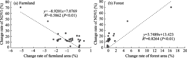
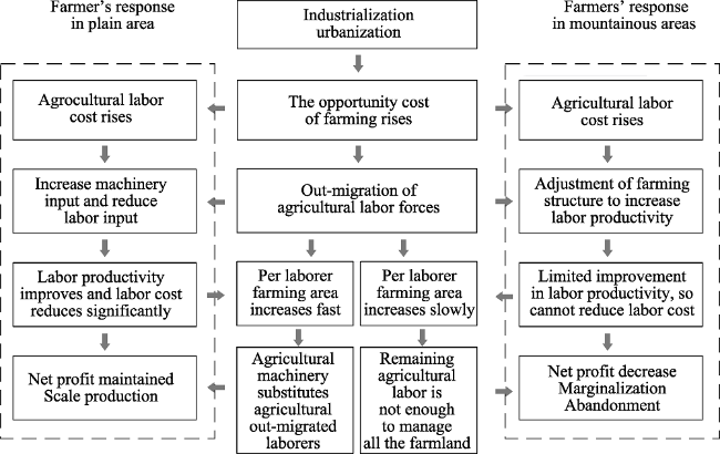
Farmland marginalization has become the main trend of land-use change in the mountainous areas of China. Using annual survey data of major agricultural production costs and earnings at national and provincial levels in China, this study aims to analyze the reasons and mechanism behind farmland marginalization in mountainous areas. We find that farmers on plains are able to reduce their per mu labor input effectively through intensive use of agricultural machinery, which has minimized the impact of the increase in labor price. However, it is extremely challenging for farmers in mountainous areas to use the same method owing to the rough terrain. Thus, per laborer farming area in these areas has increased relatively slowly, causing a widening gap in agricultural labor productivity between the two regions. With the rapid rise in labor costs since 2003, the marginalization of cultivated land in mountainous areas is evident. In 2013, the net profit of agricultural production in mountainous China fell below zero. Since 2000, the land-use and land-cover change in these areas was characterized by the reduction of farmland area, reforestation, and the enhancement of the NDVI value. The high correlation between the NDVI change rate and the ratio of change in farmland (r = -0.70) and forest (r = 0.91) in mountainous areas at provincial level further attests to the trend of farmland marginalization there. Finally, we summarize the mechanism of such marginalization against the backdrop of the rapid increase in the opportunity cost of farming and the rapid fall of agricultural labor forces in mountainous areas. This study contributes to a deep understanding of the development process of farmland marginalization and abandonment as well as forest transition in Chinese mountainous areas.

Cite this article

LI Shengfa , LI Xiubin . The mechanism of farmland marginalization in Chinese mountainous areas: Evidence from cost and return changes[J]. Journal of Geographical Sciences, 2019 , 29(4) : 531 -548 . DOI: 10.1007/s11442-019-1613-2

1 Introduction

The marginalization of land refers to the continuous reduction of the economic productivity of certain types of land use under the combined impacts of various factors, such as social, economic, and environmental changes (Liu et al., 2005). When the land net profit is reduced to zero or less, current land-use type shifts to a more extensive type. If there is no alternative to economical productivity, the land will be abandoned. Farmland abandonment is the most obvious manifestation of farmland marginalization. Since the second half of the 20th century, noteworthy farmland abandonment and the subsequent restoration of abandoned farmlands (forest transition) have been occurring in many hilly and mountainous regions around the world, especially in mountainous areas of Europe (Meyfroidt et al., 2011). According to existing knowledge, current global farmland marginalization and abandonment are the result of the exodus of agricultural labor forces, under the processes of industrialization and urbanization (Rudel et al., 2005; Lambin et al., 2010; Li et al., 2017a). Since China reached the Lewis turning point in 2003 (Zhang et al., 2011a), the trend of farmland marginalization in parts of China is likely to be obvious, and the number of reports about farmland abandonment has continued to increase (Li et al., 2017a). The China Household Finance Survey, conducted by the Southwestern University of Finance and Economics, reported that 13.5% of agricultural land nationwide in 2011 and 15% in 2013 were idle (Gan et al., 2015). Case studies show that farmland abandonment mostly occurred in mountainous areas (Li et al., 2017a), such as Chongqing Municipality (Zhang et al., 2011b; Li et al., 2013; Shi et al., 2016), provinces of Sichuan (Xu et al., 2010), Fujian (Luo, 2008; Yi, 2014), western Hunan (Huang et al., 2009; Luo et al., 2015), Guizhou (Zhao et al., 2016), southern Ningxia (Tian et al., 2010), southeastern Gansu (Chang, 2014), and southern Jilin (Zhao, 2012).
Existing studies have revealed the reasons and influencing factors of farmland abandonment at parcel level (Gellrich et al., 2007; Zhang et al., 2014a; Shi et al., 2016) and household level (Li et al., 2014; Yan et al., 2016). At parcel level, zero rent is the root cause of farmland abandonment (Zhang et al., 2014b); at household level, the rise of farming opportunity costs leads to farmers’ decision to abandon farming (Li et al., 2011; Yan et al., 2016); while the underlying drivers are industrialization and urbanization (MacDonald et al., 2000; Kozak, 2003; Li et al., 2011). However, there is no comprehensive summary of the mechanism of farmland marginalization. In particular, there is no quantitative analysis of the reasons why farmland marginalization mainly occurs in mountainous areas. Therefore, using the data from China Agricultural Production Costs and Returns Compilation, this study analyzes the changes of labor costs in China’s agricultural production since the mid-1990s, as well as the response of farmers to labor costs. By comparing the different responses of farmers in mountainous and plain areas to the rising labor costs, and the different results of costs and returns in agricultural production, this study first analyzes the economic characteristics of farmland marginalization in mountainous areas. Next, using land-use data and remote-sensing data, this study analyzes the changes of farmland and forest area and the spatio-temporal variation characteristics of the vegetation index in mountainous areas of China from 1990 to 2010. The analysis results are able to present realistic evidence of farmland marginalization in China. Finally, we summarize the whole process and mechanism of farmland marginalization in China’s mountainous areas.

2 Materials and methods

2.1 Materials

The national and provincial data of agricultural production costs, benefits, and labor use used in this study are from China Agricultural Production Costs and Returns Compilation. The compilation is published annually by the Department of Price, which is under the supervision of China’s National Development and Reform Commission. The data for total power of agricultural machinery of Chongqing Municipality and Heilongjiang Province are derived from Chongqing Statistical Yearbook and Heilongjiang Statistical Yearbook, respectively. Land-use data come from the China Eco100-Spatiotemporal Distribution Dataset of Ecosystem Types in China (1990-2010), which were produced by the Institute of Geographic Sciences and Natural Resources Research, Chinese Academy of Sciences. These data include seven types of ecosystems, which are farmland, forest, grassland, wetland, desert, settlement, and others, with a resolution of 100 m. The comprehensive evaluation accuracy of the data is 94.3% (Xu et al., 2017). The NDVI data come from the China MODIS-NDVI monthly synthetic product downloaded from Geospatial Data Cloud (http://www.gscloud.cn/) with a spatial resolution of 250 m.

2.2 Research framework

Farmland marginalization is defined a process of declining land rent under current land-use type. The increase of cost, the decrease of income, or the combination of both will cause rent to decrease. In order to promote farmers’ enthusiasm for grain production, stabilize national grain production, and increase farmers’ incomes, the Chinese government has continuously introduced beneficial farming policy, like tax exemptions or reductions, direct subsidies, and raising of state procurement prices for grains since 2004, thereby implying that the main reason for the decline in farmland rent is the increase in costs. During the processes of industrialization and urbanization, the rapid increase in farming costs was mainly caused by the rise of agricultural labor cost. Specifically, after the Lewis turning point, the rise in the non-agricultural wage leads first to a rise in farming opportunity cost and then to a rise in the agricultural labor price. Agricultural labor costs are related to labor price and labor use per mu (1 mu = 666.7 m2). Under the premise of no change in labor use per mu, a substantial increase in the labor price inevitably leads to a rapid increase in labor costs. Meanwhile, when the farming opportunity cost increases, farmers reallocate family laborers with the goal of the household utility maximization, based on the quantity and quality of the household labor force and farmland. Hence, an increasing number of farmers would enter off-farm industries. Therefore, under the joint influence of a rural labor exodus and rising labor prices, farmers would adjust their farming practices to maximize their labor productivity rather than land productivity (Chen et al., 2009; Xu et al., 2015), in order to reduce labor use per mu, with the final aim of reducing labor costs (Tian et al., 2009; Xin et al., 2011). These adjustments include farming structure and cropping system adjustment, farmland area adjustment, and adopting factor substitution (Xin et al., 2011; Yan et al., 2016).
For the adjustment of farming structure and cropping systems, a rapid rise of agricultural labor costs would impel farmers to expand plantings of crops with higher labor productivity, and reduce those with lower labor productivity. For example, farmers in southern China recently have tended to increase the vegetable planting area and reduce the rice planting area, and have changed double cropping of rice to single cropping; while farmers in northern China have tended to reduce the cultivated area of wheat and expand the area of maize (Wang et al., 2015).
For the adjustment of farmland area, a rapid rise of agricultural labor costs would encourage some famers to rent out their farmland, while other farmers with higher labor productivity would rent more farmland to enlarge farming scale (Xin et al., 2011), thereby realizing large-scale production and enhancing overall agricultural labor productivity.
Factor substitution is farmers’ direct response to the relative price changes among the factors. According to the theory of induced technical innovation, when the price of agricultural labor rises and makes labor cost become the most important restraint factor in agricultural production, it induces farmers to adopt labor-saving agricultural technologies (Zhu et al., 2007; Xin et al., 2011), that is, to increase labor-saving input in order to reduce labor input (Chen et al., 2009).
Because there are significant differences in natural conditions, adjusted farming practices vary between farmers in mountainous and plain areas. Such differences would result into different changes per mu labor days, agricultural labor productivity, labor costs, and net profit (rent), and subsequently to different changes in land-use types, which are eventually revealed in land use and cover map. Farmland marginalization would lead to land abandonment and land-use type changes in favor of revegetation and reforestation in hilly and mountainous areas. Under these assumptions, total farmland area should decrease in mountainous areas while forest areas should expand (Figure 1).
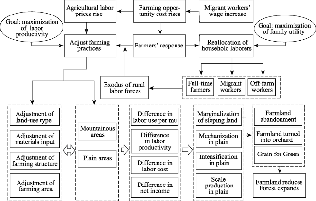
Figure 1 Research framework of farmland marginalization

2.3 Methods

There are many ways to measure agricultural labor productivity, such as per laborer yield or net output value, per laborer farming area, and labor use per unit of agricultural products. In order to compare agricultural labor productivity in different regions and different periods, this study uses the grain yield per unit of working days. The equation for this calibration is as follows:
E= P / L (1)
where E is agricultural labor productivity, P is grain yield per mu, and L is labor use per mu.
Compared with the change of land-use types, the NDVI is more timely in reflecting the information about land-cover change. After farmlands are abandoned, the time for vegetation restoration varies greatly among regions. Even in the southern mountainous areas with abundant rainfall, the restoration of vegetation after farmland abandonment is a gradual process. In a few years after abandonment, the abandoned land might not change significantly in land-use type, but its status of utilization can be reflected by the NDVI. Therefore, in addition to the analysis of changes in land-use types in mountainous areas, this study also uses the NDVI data to analyze the vegetation changes and the correlation between the NDVI change and the change of farmland and forest area. The major difference between the annual NDVI curves of abandoned farmland and managed farmland is the duration of high values; the former is longer than the latter (Alcantara et al., 2012). Thus, the annual average value of the NDVI can more effectively reflect the development of farmland marginalization in mountainous areas than the maximum value can. Consider the need for time to restore vegetation, we choose the annual average rate of NDVI changes from 2000 to 2013 to reveal the overall trend of vegetation in mountainous areas.
Owing to the ambiguities and uncertainties of the definition of mountainous areas (Jiang et al., 2009), it is very difficult to define a mountain range accurately. In addition, the main focus of this study is the difference in rural response between households in rugged terrain and those in flat areas. Therefore, this study does not strictly define mountainous areas and plains. Instead, when analyzing the changes of costs and benefits, owing to the data limitation, we select provinces (includes municipalities) with the most obvious topographic features as proxies for mountainous and plain areas. Based on the topographical features of each province and their proportion of sloping farmland, seven provinces and municipalities with the highest proportions of mountainous and hilly area and the highest proportions of cultivated land (above 6 degrees) were chosen to represent mountainous areas, namely, Chongqing, Guizhou, Yunnan, Sichuan, Gansu, Shanxi, and Shaanxi. Excluding Shanxi and Gansu, the other five provinces have more than 60% of sloping farmland, of which the highest proportion is Chongqing Municipality, the typical representation of mountainous areas, with about 85% of sloping farmland. Seven provinces with the highest percentages of plain area and the highest proportion of flat farmland (less than 6 degrees) are selected to represent plains, namely, Heilongjiang, Jilin, Hebei, Shandong, Henan, Jiangsu, and Anhui. Excluding Jilin, the proportion of flat farmland in other provinces is more than 90%, of which the per laborer farmland area in Heilongjiang is as high as 30.5 mu. Hence, Heilongjiang is a typical representative of China’s agricultural mechanization and large-scale production in plain areas. When analyzing the changes of land use and cover, in order to understand the changing characteristics of mountainous areas better, this study uses mountain counties (MCs) defined by the China County Statistical Yearbook as the analysis area in contrast to hilly counties (HCs) and plain counties (PCs). According to the definition of the China County Statistical Yearbook, mountain counties refer to those with mountainous areas of more than 80%, of which there are about 900 counties, accounting for about 45% of the total land area.

3 Results

3.1 Changes in agricultural labor costs and farmers’ response

3.1.1 Agricultural cost change
Since 2003, the wage of migrant workers in China has risen rapidly by about 10% every year (Xin et al., 2011; Lu, 2012), leading to an increase in farming opportunity cost, which in turn has led to a rapid increase of labor costs in agricultural production. During 2003-2013, employed wages of agricultural laborers increased by 5.1 times, while the costs of agricultural materials and services (excluding machinery service fee) only doubled. Therefore, in per mu agricultural production costs, labor costs are rising at a higher rate than the costs of agricultural materials and services. By 2011, the labor costs of the three main grain crops in China reached 283 yuan/mu and exceeded the costs of agricultural materials and services for the first time, becoming the main cost in agricultural production (Figure 2).
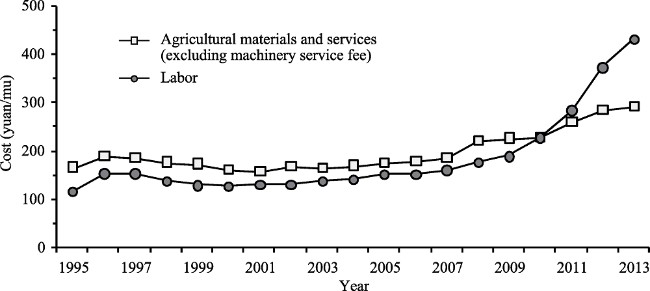
Figure 2 The labor, materials, and service costs for China’s three main grain crops since 1995
Data: China Agricultural Production Costs and Returns Compilation
3.1.2 Farmers’ response to the rise of labor costs
Since 2003, with the rapid rise of the price of the agricultural labor force, the capital investment structure in agricultural production in China has tended to rise in proportion with labor-saving input, especially the input of machinery. From 2003 to 2013, the machinery service fee grew 419%, and pesticides fee also increase 193%, while the fees for seedlings, chemical fertilizer & farmyard manure, and irrigation & drainage increased only by 193%, 190%, 147% and 59%, respectively. The previous major input of labor-saving animal power was gradually replaced by machinery, decreasing by 33% (Figure 3). Owing to the fast increase in labor-saving input, the per mu labor use for three main grain crops (rice, wheat and maize) in China decreased 44% from 11.1 days to 6.2 days. Therefore, although the price of the agricultural labor force increased dramatically during this period, the labor cost proportion of agricultural production in China did not rise sharply, increasing only from 36.5% to 41.8%.
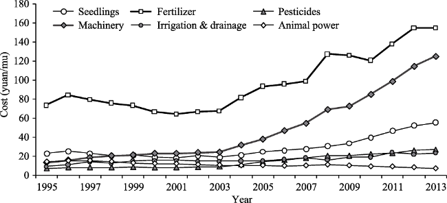
Figure 3 Different types of materials and service costs for China’s three main grain crops since 1995
Data: China Agricultural Production Costs and Returns Compilation

3.2 Different responses of farmers between mountainous and plain areas

3.2.1 Slow agricultural mechanization in mountainous areas
To better reveal the differences in the development of agricultural machinery between plains and mountainous areas, we examine the development of agricultural machinery of Heilongjiang and Chongqing, the typical representatives for plains and mountainous areas, respectively. Since 2003, the gap between Heilongjiang and Chongqing has expanded significantly, both in the total and per laborer power of agricultural machinery. During the period 2003-2013, the total power of agricultural machinery in Heilongjiang increased by 1.7 times, while that in Chongqing increased by only 0.7 times. Heilongjiang’s per laborer power of farm machinery increased by 1.8 times and that of Chongqing by only 1.2 times. The gap of per laborer power between the two regions increased from 1.8 kW to 4.1 kW (Figure 4). In addition, the agricultural mechanization level in both regions is significantly different. In 2010, the proportion of machine-harvested maize production in Heilongjiang reached as high as 97%, compared with only 16% in Chongqing.
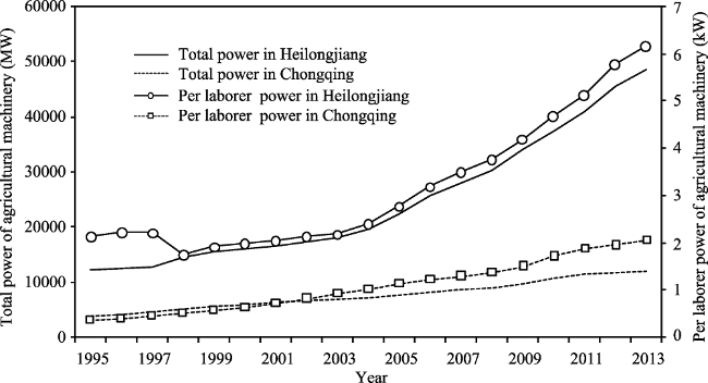
Figure 4 Comparison of agricultural mechanization between Heilongjiang and Chongqing
3.2.2 Higher per mu labor use in mountainous areas
In 2003, the average per mu labor use for maize production in the plain provinces (PPs) was 8.4 days, and decreased 37% to 5.3 days in 2013, while the average per mu labor use for maize production in mountainous provinces and municipalities (MPMs) declined 30% from 16.9 days to 11.9 days. Although there was also a significant decrease in per mu labor use in MPMs, the gap between MPMs and PPs was still significant. In 2013, the amount of per mu labor use in MPMs was still more than twice that in PPs. The map of per mu labor use shows that per mu labor use in MPMs, such as southwest China, was significantly higher than that in PPs, such as north China and northeast China, presenting an overall increasing trend from northeast to southwest (Figure 5). Only 3.1 days per mu were needed in Heilongjiang, while the amount of labor use per mu in Guizhou, Yunnan, Gansu, and Chongqing with rugged terrain is still more than 13 days, a difference of more than 3 times compared with Heilongjiang.
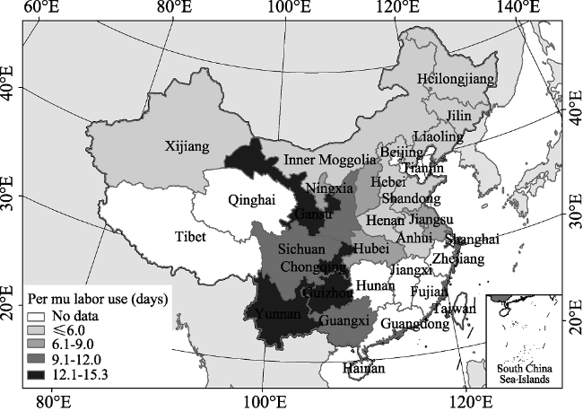
Figure 5 Per mu labor use for maize cultivation at provincial level in 2013
3.2.3 Mounting share of agricultural labor costs in mountainous areas
Because of the slow development of mechanization in mountainous areas, the growth rate of agricultural machinery input is lower than the rate at which agricultural labor costs rise. Therefore, the cost savings resulting from increased labor-saving input are not enough to offset the increased labor costs. Taking maize cultivation as an example, its labor cost share of MPMs, except for Sichuan, generally showed a significant upward trend during 2003-2013. The average share of the seven MPMs increased from 53.82% in 2003 up to 63.10% in 2013. By contrast, the labor cost share of PPs, except for Hebei and Jiangsu, showed a significant downward trend during 2003-2013. The average share of the seven PPs declined from 43.88% in 2003 to 30.68% in 2013 (Figure 6).
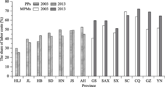
Figure 6 Changes in the proportion of agricultural labor costs (maize) between MPMs and PPs
Notes: HLG = Heilongjiang, JL = Jilin, HB = Hebei, SD = Shandong, HN = Henan, JS = Jiangsu, AH = Anhui, GS = Gansu, SAX = Shaanxi, SX = Shanxi, SC = Sichuan, CQ = Chongqing, GZ = Guizhou, YN = Yunnan

3.3 Regional differences in agricultural labor productivity and net profit

3.3.1 Differences in agricultural labor productivity
Nationally, the increasing input of agricultural machinery has effectively replaced the labor force, thereby promoting the rapid increase of agricultural labor productivity. Again taking maize cultivation as an example, from 1990 to 2003, agricultural labor productivity maintained slow growth, while after 2003, with a substantial increase in investment in machinery, it has risen rapidly at an average annual rate of 8.5% (Figure 7).
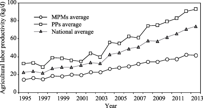
Figure 7 Changes of average labor productivity in maize cultivation between MPMs and PPs
The significant disparity in the agricultural mechanization level under different topographical conditions leads to the difference of per mu labor use and further to a disparity in agricultural labor productivity. Since 2003, the gap of average labor productivity between MPMs and PPs has shown a distinct widening trend. In 2003, the average labor productivity of the seven MPMs was 22.55 kg/d, while that of the seven PPs was 39.53 kg/d, the latter being 1.75 times the former. By 2013, the average labor productivity of the seven MPMs increased to 41.38 kg/d, while that of the seven PPs increased sharply to 93.24 kg/d, expanding the gap to 2.25 times (Figure 7). The same conclusion is reached by calculating the output value per laborer.
3.3.2 Differences in agricultural net profit
Due to the slow increase in agricultural labor productivity in mountainous areas, agricultural labor costs cannot be squeezed effectively by increasing relatively cheap mechanical inputs, like in the plains, as rising labor prices have resulted in a decrease in net profit in mountainous areas. Comparing maize production in MPMs and PPs, the net profit of the whole nation has been fluctuating since 2000 owing to the price fluctuation. However, the gap of net profit between the PPs and MPMs has shown an increasing trend. The gap of per mu net profit (comparable price, without land cost) increased from 102 yuan to 197 yuan during 2004 to 2013 (Figure 8).
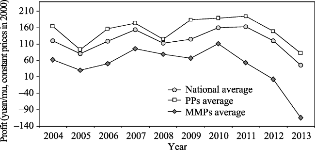
Figure 8 Changes in net profit of maize cultivation between MPMs and PPs
By comparing the per mu net profit of every province and municipality in 2004 and 2013, we find that both MPMs and PPs’ per mu net profits show a downward trend, but the decline in the MPMs was greater than that in the PPs. Except for Shanxi, all MPMs’ per mu net profit dropped drastically. The average per mu net profit in Chongqing, Guizhou, Yunnan, Shaanxi, and Gansu even dropped below zero, which is in sharp contrast to PPs (Table 1).
Table 1 Comparison of maize net profits in MPMs and PPs (yuan/mu, constant price in 2000)
Type Name 2004 2013 Change
MPMs Chongqing 105.86 -139.00 -244.86
Sichuan 169.91 7.14 -162.77
Guizhou 15.86 -367.73 -383.59
Yunnan -3.86 -208.22 -204.35
Shaanxi 42.17 -47.53 -89.70
Gansu -49.97 -188.38 -138.40
Shanxi 154.62 140.00 -14.62
PPs Jiangsu 244.06 84.12 -159.94
Anhui 201.81 64.96 -136.85
Jilin 56.91 39.87 -17.04
Heilongjiang 75.19 90.29 15.10
Henan 179.29 61.57 -117.72
Hebei 177.45 153.06 -24.39
Shandong 215.46 83.04 -132.42

3.4 Land-use and land-cover change in mountainous areas

3.4.1 Land-use change
(1) Farmland change
During the period 1990-2000, farmland in Chinese MCs was in a stage of increasing owing to massive land reclamation. The farmland area increased by 1.23% in this decade. The newly cultivated land was mainly distributed in northeast China, while there was also substantial land reclamation in Xinjiang, Ningxia, and Gansu provinces (Figure 9). PCs and HCs increased by 0.71% and 3.22%, respectively, during this decade. After 2000, the land reclamation in MCs lessened quite obviously, and the cultivated area has decreased. During the period 2000-2010, the cultivated land in MCs decreased by 1.13%, while that in PCs and HCs decreased by 0.20% and 1.04%, respectively.
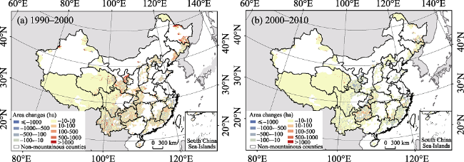
Figure 9 Farmland area changes from 1990 to 2010 in Chinese MCs
Notes: Each pixel in Figures 9 and 10 is 10 km ×10 km.
From 1990 to 2000, there were 468 MCs with a net decrease of farmland, accounting for 52% of the total number of MCs, while the proportions of counties with a net decrease of farmland in PCs and HCs were 71% and 56%, respectively. The high proportion of net decrease in PCs was caused by massive construction land expansion in the coastal plain areas. During 2000-2010, the changes of cultivated land in PCs were similar to those in the previous decade, and the number of counties with a net decrease of farmland increased by 61, with the proportion increasing to 78%. However, the number in MCs and HCs increased significantly, especially in MCs, where the number increased from 468 to 712 and the proportion expanded to 79%. Correspondingly, the number of MCs with a net increase of farmland decreased from 411 to 114 (Table 2). Overall, since 2000, the reduction of farmland in MCs of China is more evident than in HCs and PCs.
Table 2 Numbers of counties with different types of farmland area changes
Type 1990-2000 (Number) 2000-2010 (Number)
Net increased Unchanged Net decreased Net increased Unchanged Net decreased
PCs 252 3 615 182 12 676
HCs 234 1 303 75 8 455
MCs 411 25 468 114 78 712
A further comparison of Chongqing and Heilongjiang shows that Chongqing, the representative of mountainous areas, decreased its farmland by 1.9% from 2000 to 2010, with all 13 MCs showing a decreasing trend; meanwhile Heilongjiang, with relatively good topographical conditions, increased its farmland by 0.07% during 2000-2010, and 12 out of 15 MCs’ farmland area remained about the same or increased only slightly.
(2) Forest change
During the period 1990-2000, the decrease of forests in the MCs was mainly distributed in northeast China, chiefly due to farmland expansion and deforestation. Fujian, Zhejiang, and western Xinjiang had obvious forest growth, while deforestation and afforestation activities coexisted in southwest China (Figure 10). During this period, the forest area in Chinese MCs decreased by 0.4%, while that in the PCs and HCs increased by 0.87% and 1.6% respectively.
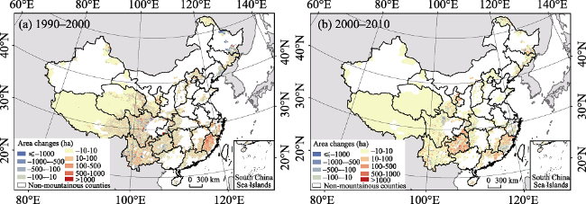
Figure 10 Forest area changes from 1990 to 2000 in Chinese MCs
During the period 2000-2010, the range of forest reduction in Chinese MCs obviously shrank, but there was no region of massive forest reduction. The implementation of the Grain for Green Project (GGP) and other ecological projects combined with the natural restoration of abandoned farmland have led to the continuous increase of forest area in Chinese MCs, especially in ecologically fragile areas, such as Guizhou, Chongqing, and Loess Plateau. During this period, the forest area in MCs increased by 0.19%, while that in PCs and HCs decreased by 0.52% and 0.42%, respectively. Similarly, comparing the forest area change in Chongqing and Heilongjiang, the forest area in Chongqing increased by 1.70% during 2000-2010, while that in Heilongjiang decreased by 0.24%.
3.4.2 NDVI change
(1) NDVI changes in mountainous areas from 2000 to 2013
During 2000-2013, the annual average NDVI value in Chinese MCs tended to increase gradually at an increase rate of 9.9%. Among all the provinces (MCs range only), Inner Mongolia and Ningxia had the largest increase rates of 33% and 23%, respectively, followed by Shanxi, Gansu, Qinghai, Guizhou, Guangxi, Hainan, Guangdong, and Fujian provinces, which had increase rates of more than 10%. The increase of NDVI in northeast China was the smallest, while the increase rates in Heilongjiang, Jilin, and Liaoning provinces were less than 4% during the period; the local reduction of NDVI in these areas might have been caused by the decrease of precipitation (Figure 11).
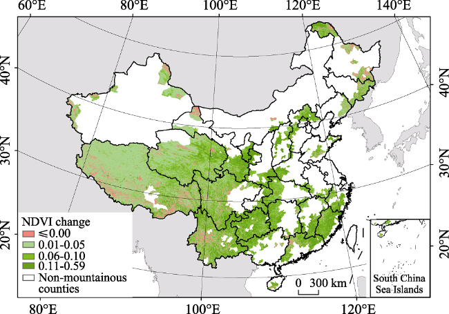
Figure 11 NDVI variations within Chinese MCs from 2000 to 2013
(2) Correlation between NDVI and land-use change
The Pearson’s correlation coefficient between the rate of farmland area change (2000-2010) and the rate of NDVI change (2000-2013, within farmland area in 2000) in the MCs at provincial level reached -0.70 (P<0.01), showing a strong negative correlation. On the other hand, the Pearson correlation coefficient of forest area change rate (2000-2010) and NDVI change rate (2000-2013) ranged up to 0.91 (P<0.01), showing a strong positive correlation (Figure 12).
Figure 12 Correlation between farmland and forest area change rate and the NDVI change rate within MCs

4 Discussion

4.1 Evidence of and reasons for farmland marginalization in mountainous areas

In this study, we analyzed the changes in agricultural cost structure and compared the different response capabilities of farmers between mountainous and plain areas since 2003. We established that the root cause of farmland marginalization and abandonment always occurring in mountainous areas rather than plain areas is the sharp decline in net profit, even to below zero (zero rent), which is in accordance with the results of Zhang et al. (2014b). The sharp drop in net profit is the result of larger per mu labor use and low agricultural labor productivity. The declining rent demonstrates that farmland in Chinese mountainous areas is in the process of marginalization. Furthermore, since 2000, farmland and forest area in Chinese MCs have opposite growth trends, which is consistent with rising agricultural labor costs and decreasing net profits. The results of the correlation analysis confirm the trend of farmland decrease and forest expansion in Chinese mountainous areas since 2000, which provides good realistic evidence for this study’s findings. In addition, a national scale sample survey for farmland abandonment in Chinese mountainous regions, which was carried out by our research team, established that 78.3% of surveyed villages have experienced farmland abandonment and about 15% of farmland was abandoned in 2015 (Li et al., 2017b). Massive farmland abandonment occurred mainly after 2000, which is in line with the trend toward a rapid rise of agricultural labor costs.

4.2 The mechanism of farmland marginalization

The main force driving farmland marginalization that this study revealed is similar to that in western Europe (Doorn et al., 2007; Gellrich et al., 2007) and Latin America (Aide et al., 2004), that is, farmland marginalization in Chinese mountainous areas is the result of rural exodus caused by rapid industrialization and urbanization. By summarizing the evidence of farmland marginalization in Chinese mountainous areas in this and other existing research (Rudel et al., 2005; Tian et al., 2009; Zhang et al., 2014a, b; Yan et al., 2016; Li et al., 2017a), we can establish the mechanism of farmland marginalization as follows. As urbanization and industrialization provide abundant job opportunities, the wage for the off-farm labor force rises rapidly after the Lewis turning point. Rising farming opportunity cost leads more and more farmers, especially young farmers, to choose to seek off-farm work in urban areas rather than be engaged in agricultural production. This outcome further raises the price of agricultural labor. Against this backdrop, improving agricultural labor productivity and reducing labor input is the most efficient way to avoid farmland marginalization. The ways to improve agricultural labor productivity include maximizing labor productivity by adopting large-scale and intensive farming practices, using labor-saving machinery to substitute expensive agricultural labor (Zhu et al., 2007), or increasing the cultivated area of crops with higher labor productivity to reduce the costs induced by the rising wage of agricultural labor (Tian et al., 2009). The vast differences in natural conditions between mountainous and plain areas, especially topographical conditions, lead to different choices of farmers in ways to improve agricultural labor productivity. In plain areas, farmers can substantially increase the input of labor-saving agricultural machinery to replace labor, thereby significantly increasing labor productivity, reducing labor costs, and avoiding farmland marginalization. In mountainous areas, rugged terrain seriously impedes the development of agricultural mechanization. Farmers in these areas normally improve their labor productivity only by adjusting the farming structure and system. However, the effect of such adjustment is limited and thus, their agricultural labor productivity grows slowly. Then, the share of labor costs of agricultural production increases, entailing declining profitability in agricultural production and the inevitable farmland marginalization (Strijker et al., 2005).
From the viewpoint of agricultural labor force out-migration, in the process of land marginalization, owing to the rugged terrain in mountainous areas, the per mu labor use is obviously higher than that in plain areas. Hence, the per laborer farming area in mountainous areas is far less than that in plain areas. During the process of rapid urbanization, a rural exodus would lead to an increase of machinery inputs in the plains to substitute for reducing agricultural laborers, thereby resulting in a large increase in per laborer farming area. However, the out-migrated agricultural labor in mountainous areas cannot be substituted by agricultural machinery. Consequently, poor and remote farmland would be marginalized when all agricultural land cannot be managed, and then this farmland would be abandoned (Figure 13).
Figure 13 Mechanism of farmland marginalization in Chinese mountainous areas

4.3 Policy implications

Farmland marginalization in mountainous and hilly areas has become a widespread phenomenon when the economy of a country or region develops to a certain level. Farmland marginalization has far-reaching impacts on the socio-economy and ecological environment (Queiroz et al., 2014; Li et al., 2017a). Therefore, eliminating the negative impact of farmland marginalization in mountainous areas should be the focus of future research. With the introduction of the National New-Type Urbanization Plan, China’s urbanization process is expected to maintain rapid development. The labor wage will probably continue to rise fast, thereby promoting the out-migration of rural labor in the mountainous areas and the marginalization of cultivated land. Without the implementation of effective public policies, more and more sloping farmland in mountainous areas is likely to be abandoned or shifted to other high-yielding or labor-saving agricultural products, such as fruit, tobacco, and wood.
Generally, the outmigration of rural labor could improve the vegetation cover in ecologically fragile areas (Li et al., 2016). In terms of Chinese mountainous areas, farmland marginalization, combined with firewood substitution and the fading livestock system is highly conducive to improving the ecological environment there (He et al., 2016), and is a powerful guarantee for the success of GGP. However, as a country with very little cultivated land per capita and a large proportion of slopping farmland, the impact of farmland marginalization in mountainous areas on food security could be noteworthy, and thus, is likely to remain an issue that cannot be ignored. According to the analysis results of this study, the key to alleviate farmland marginalization in mountainous areas is to improve agricultural labor productivity. There are two main ways to improve labor productivity. The first is to achieve proper land scale management through land consolidation and farmland transfer to increase the utilization of agricultural machinery, in order to reduce labor input in agricultural production. The second way is to increase the value added of agricultural products, for example, by promoting the cultivation of agricultural products with special local characteristics and that cannot be farmed by machinery, in order to raise economic output per laborer.

5 Conclusions

With the progress of industrialization and urbanization in China, the out-migration of rural labor forces, and the rising farming opportunity cost have led to noteworthy farmland marginalization in mountainous areas. The economic characteristics of farmland marginalization are as follows.
First, since 2003, driven by the rapid rise of the agricultural labor wage, the input of agricultural machinery has increased sharply. Due to restrictions from topographical conditions, the development of agricultural mechanization in mountainous areas has been hindered. The labor use per mu of agricultural production is far greater than that in the plain areas, resulting in an obvious increase in farming cost.
Second, due to differences in the level of mechanization, the gap of average labor productivity in maize production between mountainous and plains areas widened from 1.75 times in 2003 to 2.25 times in 2013.
Third, because of the slow growth of agricultural labor productivity in mountainous areas, with the labor wage increase, net profit of agricultural production declined sharply. In 2013, the net profit of maize production in the MPMs generally dropped to below zero.
Fourth, owing to farmland marginalization in mountainous areas, the restoration of abandoned farmland and the implementation of GGP have led to a general trend of decreasing cultivated areas, increasing forest areas, and increasing NDVI in mountainous areas since 2000.
Finally, the main driving force of the marginalization of cultivated land in China’s mountainous areas is the rising cost of agricultural opportunity and the out-migration of rural labor forces, caused by industrialization and urbanization. The key reason is that mountainous terrain restricts the substitution of machinery and labor productivity increases slowly. The root cause of farmland marginalization and abandonment is the decline of net profit to below zero, which results from the sharp increase in the agricultural labor cost. At the household level, farmland marginalization is the result of optimal allocation of household land and labor resources. At the regional level, farmland marginalization is led by the combined effect of a slow increase in agricultural productivity and a drastic reduction in the agricultural labor force.

The authors have declared that no competing interests exist.

[1]
Aide T M, Grau H R, 2004. Globalization, migration, and Latin American ecosystems.Science, 305(5692): 1915-1916.

DOI

[2]
Alcantara C, Kuemmerle T, Prishchepov A V,et al., 2012. Mapping abandoned agriculture with multi-temporal MODIS satellite data.Remote Sensing of Environment, 124: 334-347.78 Agricultural abandonment can be mapped across large areas from MODIS 250m. 78 Abandoned agriculture was widespread in Eastern Europe (15.1% of the total area). 78 Using multiple years of MODIS data did not increase classification accuracy. 78 Phenology metrics in conjunction with NDVI data improved classification accuracies.

DOI

[3]
Chen Y, Li X, Tian Y,et al., 2009. Structural change of agricultural land use intensity and its regional disparity in China.Journal of Geographical Sciences, 19(5): 545-556.Based on the cost-income data of farm produce and the China Agricultural Yearbook,this paper divided the intensity of cultivated land use into labor intensity and capital intensity,then analyzed their temporal and spatial change at both country and provincial scale in the period of 1980-2006.The results showed that:(1) On country scale,labor intensity of food crop farming decreased from 398.5 day/ha in 1980 to 130.25 day/ha in 2006;and shows a continuous decrease with a steep decline in 1980-1986,a slower decline in 1987-1996,and another steep decline in 1997-2006.On the contrary,capital intensity shows an increasing trend from 1980.In the internal composition of capital intensity,the proportion of seed,chemical fertilizer and pesticide input decreased from 90.36% to 73.44% ;the proportion of machinery increased from 9.64% to 26.56%.The less emphasis on yield-increasing input and more emphasis on labor-saving input are the main reasons for a slow increase of yield per unit area after 1996.(2) On provincial scale,the economically developed areas have lower labor intensity and higher capital intensity.The less developed areas have higher labor intensity but lower capital intensity.From the internal composition of capital intensity view,labor-saving input accounts for more proportion in the developed areas than other areas.That is because in these developed areas,as more and more labors engaged in off-farm work,labor input has become a constraint factor in food production.Farmers increase the labor-saving input for higher labor productivity.However,in less developed areas,the major constraint is the shortage of capital;food production is still depending on labor and yield-increasing inputs.

DOI

[4]
Chuang Y, 2014. Investigation and thinking on the cropland abandonment in Jingning County.Agricultural Development and Equipment, (8): 21-22. (in Chinese)

[5]
Doorn A M V, Bakker M M, 2007. The destination of arable land in a marginal agricultural landscape in South Portugal: An exploration of land use change determinants.Landscape Ecology, 22(7): 1073-1087.This research attempts to investigate what drives three conversions of arable land during the period 1985鈥2000 in a marginal agricultural landscape in Southern Portugal: afforestation of arable land, abandonment of arable land and regeneration of the agro-silvo-pastoral system. This was done by exploring the associations between these changes and a selection of both biophysical and socio-economic variables in a study area of 44 square km. For each conversion of arable land into one of the three other land use types the descriptive power of the various independent variables were evaluated using logistic regression. By comparing different statistical models (one containing only the biophysical attributes, another model containing only the socio-economic variables and finally a model containing both types of variables) the relative importance of socio-economic and biophysical variables was evaluated. The results show that both the biophysical and socio-economic variables were significantly associated with the occurrences of the land use changes. However, the models containing only the socio-economic variables were stronger related to occurrences of afforestation and regeneration of the montado, whereas the biophysical variables were more related to land abandonment. The landowner type was a significant descriptive variable across all land use change models. The results suggest that local socio-economic factors are significant in explaining the pattern of the conversion of arable land in the study area and for this reason the variety of landowners response to the physical conditions deserves more attention in land use change modelling.

DOI

[6]
Fang C, Du Y, Wang M, 2009. Migration and labor mobility in China. New York: United Nations Development Programme, Human Development Report Office.

[7]
Gan N, Yin Z, Tan Z, 2015. China Household Finance Survey Report 2014. Chengdu: Southwestern University of Finance and Economics Press. (in Chinese)

[8]
Gellrich M, Baur P, Koch B,et al., 2007. Agricultural land abandonment and natural forest re-growth in the Swiss mountains: A spatially explicit economic analysis.Agriculture, Ecosystems & Environment, 118(1-4): 93-108.Natural forest re-growth reflects a decline in traditional agricultural practices that can be observed worldwide. Over the last few decades, natural forest re-growth has replaced much of the agricultural land in the Swiss mountains. This is a region where forms of traditional cultivation have preserved unique landscapes and habitats of high ecological value. This study aimed to characterise the locations in the Swiss mountains where agricultural land has been abandoned and overgrown by trees and bushes. Therefore, multivariate statistical models based on geo-physical and socio-economic variables were developed. Land-use change data were taken from two nationwide land-use surveys carried out in the 1980s and 1990s. In order to obtain reliable models, neighbourhood effects and the group structure in our data were accounted for. For the latter a robust estimation technique known as cluster-adjustment was used. Results show that forest re-growth is largely restricted to former alpine pastures, land with grass and scrub vegetation and agricultural land with groups of trees at mid to high altitudes, steep slopes, stony ground and a low temperature sum. Some relationships were not as expected, e.g. many of the new forest areas were found to be relatively close to roads. A new finding from this study was that forest re-growth is largely restricted to regions with immigration, higher proportions of part-time farms as opposed to full-time farms and high farm abandonment rates. By accounting for neighbourhood effects, the model fit was improved. The considerable residual deviance of the models was interpreted as the result of undetected local characteristics, such as poor water availability, small-scaled topographic peculiarities (e.g. small trenches, stonewalls, soil damages by cattle) and the individual's motivation to abandon or maintain cultivation. The conclusion made was that general policy measures for the whole mountain area are not suitable for the prevention of land abandonment and forest re-growth, and that policy measures must pay more attention to local characteristics and needs.

DOI

[9]
He W, Yan J, Zhou H,et al., 2016. The micro-mechanism of forest transition: A case study in the mountainous areas of Chongqing. Journal of Natural Resources, 31(1): 102-113. (in Chinese)Since the 1980 s, China has entered a forest transition phase, which has brought us more ecological environment services. However, it still lacks a systematic understanding of the micro- mechanisms of the forest transition on household scale, which has restricted making targeted measures for restoration of forest vegetation. Based on a field survey of 1 015 households in the"two wings"region of Chongqing Municipality, using tools of participatory rural appraisal(PRA), this paper systematically analyzes the micro- mechanisms of forest transition and their influencing factors. The results show that: 1) The micro- mechanisms of forest transition include firewood substitution, cultivated land abandonment, decrease in numbers of livestock breeding and fruit planting. In terms of firewood substitution, firewood consumption per capita and the proportion of firewood consumption decreased by 354.31 kgce and 3.46% from 2003 to 2011, respectively. For cultivated land abandonment, the area of cultivated land abandonment tended to increase since the 1980 s and reached the peak between2008 and 2011. For livestock breeding, nearly 80% of investigated rural households reduced the number of livestock by 2011. As to fruit planting, although it was ever an important factor of forest transition in other regions of the world, the total area of fruit planted by the investigated households is only 9.85 hm2. 2) As the underlying cause, off-farm employment is not only in favor of firewood substitution and fruit planting, but also the reason of cultivated land abandonment and decrease in numbers of livestock breeding. In addition, the four micromechanisms of forest transition are also affected by other factors. For firewood, improving the availability of alternative energy(e.g. coal, liquefied gas), and speeding up the implementation of biogas policy can speed up firewood substitution. For abandonment, property of cultivated land(e.g. radius of farming, land quality), and invasion of wild boar can result in cultivated land abandonment. Meanwhile, disaster risk, lack of irrigation, and abandonment behavior of other farmers also have a litter impact on cultivated land abandonment. For fruit industry, the government encouraging policies can accelerate the development of fruit industry. The results perfectly reveal the development of four micro-mechanisms of forest transition in mountainous areas of Chongqing city and their influencing factors, which provides a scientific basis for policy-making to coordinate the contradiction between forest restoration and food safety.

[10]
Huang J, Li L, 2009. Dilemma of idling arable land in mountainous areas and its causes and countermeasures: Take Huitong County as an example.Journal of UESTC (Social Sciences Edition), 11(4): 11-14. (in Chinese)The dilemma of idling arable land is faced by the government officials,village officials and villagers in mountainous districts.Through survey and research,we have found many hidden problems,therefore set up a model between the acreage of idling arable land and rural human resources and put forward some suggestions on dealing with the problems,providing consults for the development of mountainous agriculture,the establishing of government policies and the security of food production.

[11]
Jiang X, Zeng H, 2009. Quantifying mountain regions of China: A case study in Sichuan.Mountain Research, 27(1): 24-32. (in Chinese)Mountain region (MR) is a more confusion and uncertainty terminology than mountains. It is defined by not only the physical characteristics (i.e. topography),but also some social-economic factors. A MR is a more continuous and integrative area than mountains at landscape scale. At the basis of the quantitative areas of the mountains in China,an edge growing model (EGM) was developed in this work to quantifying the MRs. The model utilized the spatial analysis functions in geographical information system (GIS),and the cluster analysis and logistic regression. The social-economic factors,which have high correlation with the mountains,were included in the EGM model (i.e. population,land use,GDP,and road). The EGM model was applied to quantify the MRs in Sichuan province. It was found there are 374 901 km2 MRs in Sichuan which increased 3.21% compare to mountains (i.e. from 73.56% to 76.77%). The MRs are mainly concentrated in western Sichuan; some are located in Northeastern and Southeastern Sichuan. There are much less isolated small areas in the map of mountain and non-mountain regions,comparing to the map of mountain and non-mountains. The EGM model is an effective and efficient method to delineate the mountain regions in a province or country. Furthermore,it is also portable and easy to be applied in other provinces or countries.

DOI

[12]
Kozak J, 2003. Forest cover change in the Western Carpathians in the past 180 Years: A case study in the Orawa Region in Poland.Mountain Research and Development, 23(4): 369-375.Since the 19th century a slow expansion of forests into previous agricultural areas has been recorded in the Carpathians. The present article analyzes forest cover change in the Orawa region of Poland, using historical maps and contemporary satellite data. Forest cover change was analyzed with reference to elevation, under the assumption that it reflects a transformation of the vertical land use system developed in the 17th and 18th centuries. For the past 180 years, the proportion of forest in the study area has increased from 25% to 40%. Forest expansion largely affected pastures cleared within the forest belt and areas located immediately above and below this belt. Changes in forest area were largely related to a decline in agriculture and have occurred along with population growth. As a result, grazing has been replaced by forestry, nature conservation, and tourism.

DOI

[13]
Lambin E F, Meyfroid P, 2010. Land use transitions: Socio-ecological feedback versus socio-economic change.Land Use Policy, 27(2): 108-118.The concept of land use transition highlights that land use change is non-linear and is associated with other societal and biophysical system changes. A transition in land use is not a fixed pattern, nor is it deterministic. Land use transitions can be caused by negative socio-ecological feedbacks that arise from a depletion of key resources or from socio-economic change and innovation that take place rather independently from the ecological system. Here, we explore whether the sources of land use transitions are mostly endogenous socio-ecological forces or exogenous socio-economic factors. We first review a few generic pathways of forest transition as identified in national case studies, and evaluate the varying ecological quality of expanding forests associated with these pathways. We then discuss possible explanatory frameworks of land use transitions. We use the case of the recent forest transition in Vietnam as an illustration. Socio-ecological feedbacks seem to better explain a slowing down of deforestation and stabilization of forest cover, while exogenous socio-economic factors better account for reforestation. We conclude by discussing the prospects of accelerating land use transitions in tropical forest countries.

DOI

[14]
Li J, 2013. Study on abandonment of cultivated land in mountain areas based on labor emigration [D]. Chongqing: Southwest University. (in Chinese)

[15]
Li S, Li X, 2017a. Global understanding of farmland abandonment: A review and prospects.Journal of Geographical Sciences, 27(9): 1123-1150.Since the 1950s, noteworthy farmland abandonment has been occurring in many developed countries and some developing countries. This global land use phenomenon has fundamentally altered extensive rural landscapes. A review of global farmland abandonment under the headings of “land use change–driving mechanisms–impacts and consequences–policy responses” found the following: (1) Farmland abandonment has occurred primarily in developed countries in Europe and North America, but the extent of abandonment has varied significantly. (2) Changing socio-economic factors were the primary driving forces for the farmland abandonment. And land marginalization was the fundamental cause, which was due to the drastic increase of farming opportunity cost, while the direct factor for abandonment was the shrink of agricultural labor forces. (3) Whether to abandon, to what extent and its spatial distributions were finally dependent on integrated effect from the physical conditions, laborer attributes, farming and regional socio-economic conditions at the village, household and parcel scales. With the exception of Eastern Europe, farmland abandonment was more likely to occur in mountainous and hilly areas, due to their unfavorable farming conditions. (4) A study of farmland abandonment should focus on its ecological and environmental effects, while which is more positive or more negative are still in dispute. (5) Increasing agricultural subsidies will be conductive to slowing the rate of farmland abandonment, but this is not the only measure that needs to be implemented.Due to China’s rapid urbanization, there is a high probability that the rate of abandonment will increase in the near future. However, very little research has focused on this rapid land-use trend in China, and, as a result, there is an inadequate understanding of the dynamic mechanisms and consequences of this phenomenon. This paper concludes by suggesting some future directions for further research in China. These directions include monitoring regional and national abandonment dynamics, analyzing trends, assessing the risks and socio-economic effects of farmland abandonment, and informing policy making.

DOI

[16]
Li S, Li X, Xin L,et al., 2017b. Extent and distribution of cropland abandonment in Chinese mountainous areas.Resources Science, 39(10): 1801-1811. (in Chinese)Cropland abandonment is the main land-use change in mountainous areas globally. It has profoundly altered rural land-use structure,agricultural landscapes,and farmer livelihoods in mountainous areas and has huge environmental and socioeconomic impacts. Since 2000,with the rapid rise in labor costs and the exodus of the rural labor force,croplands in China's mountainous areas have been facing a greater risk of abandonment due to rough terrain and slow development of agricultural mechanization. Case studies and reports have increasingly demonstrated that cropland abandonment in these areas is severe. Considering that sloping croplands account for about 25% of total croplands in China,cropland abandonment is not only related to informed policy-making regarding land use and sustainable rural development in mountainous areas,but possibly has a significant negative impact on food security. Quantitative analyses of cropland abandonment at a national level in China have not been performed. Hence,in this study,a large-scale survey was carried out to estimate the extent of cropland abandonment in mountainous counties to offer a scientific basis for relevant policy-making and further study of cropland marginalization. The results show that 78.3% of 235 surveyed villages have experienced cropland abandonment to some extent. During 2014-2015,the abandonment rate of croplands in mountainous counties was 14.32%,showing a distribution pattern of"south-high and north-low"at the provincial level. The abandonment rate for the Yangtze River Basin was the highest,while that for the northeastern mountainous area was the lowest.

[17]
Li S, Sun Z, Tan M,et al., 2016. Effects of rural-urban migration on vegetation greenness in fragile areas: A case study of Inner Mongolia in China.Journal of Geographical Sciences, 70(3): 1622-1631.Different government departments and researchers have paid considerable attention at various levels to improving the eco-environment in ecologically fragile areas. Over the past decade, large numbers of people have emigrated from rural areas as a result of the rapid urbanization in Chinese society. The question then remains: to what extent does this migration affect the regional vegetation greenness in the areas that people have moved from Based on normalized difference vegetation index(NDVI) data with a resolution of 1 km, as well as meteorological data and socio-economic data from 2000 to 2010 in Inner Mongolia, the spatio-temporal variation of vegetation greenness in the study area was analyzed via trend analysis and significance test methods. The contributions of human activities and natural factors to the variation of vegetation conditions during this period were also quantitatively tested and verified, using a multi-regression analysis method. We found that:(1) the vegetation greenness of the study area increased by 10.1% during 2000鈥2010. More than 28% of the vegetation greenness increased significantly, and only about 2% decreased evidently during the study period.(2) The area with significant degradation showed a banded distribution at the northern edge of the agro-pastoral ecotone in central Inner Mongolia. This indicates that the eco-environment is still fragile in this area, which should be paid close attention. The area where vegetation greenness significantly improved showed a concentrated distribution in the southeast and west of Inner Mongolia.(3) The effect of agricultural labor on vegetation greenness exceeded those due to natural factors(i.e. precipitation and temperature). The emigration of agricultural labor improved the regional vegetation greenness significantly.

DOI

[18]
Li X, Zhao Y, 2011. Forest transition, agricultural land marginalization and ecological restoration.China Population, Resources and Environment, 21(10): 91-95. (in Chinese)China ushered in the transition of its national land use morphology in the 1980s.Such a transition indicates that the space of nature represented by forest area down to a trough reversed upward,while the intensively-used space represented by cropland,from expansion to contraction.It is one of the most direct causes of the change in ecological state of the country from the overall deterioration to the overall improvement.Forest transition corresponds to the evolution stage of national economic and social development process.Its direct reason is that agriculture loses out in the competition with forestry for land resources in the ecotone between forest and cropland.The rising labor costs with industrialization and urbanization and the increasing demand for forest products with the improved living standards enhance the competitiveness of forestry to agriculture,while pre-transition ecological degradation caused by agricultural expansion triggers the implementation of the governmental policies favored forestry.Governmental policies played a key role in the early stages of China's forest transition.With the accelerated development of urbanization and aged society,China ushered in the continuously rising stage of labor wages.Slopeland cropping would tend to be "marginalized" because it is not easy in mechanization compared to the agriculture in plain area.This gives room for the further expansion of forest area or natural space.

[19]
Li Z, Yan J, Hua X,et al., 2014. Factors influencing the cultivated land abandonment of households of different types: A case study of 12 typical villages in Chongqing Municipality.Geographical Research, 33(4): 721-734. (in Chinese)In recent years, land abandonment has become a great concern in academia, as it has linkages with cropland loss and grain security. The study on the drivers and determinants of cultivated land abandonment will help the policy makers to formulate better land use planning, land consolidation and land program. Most studies take farmers as a whole, while few consider the difference among farmers' behaviors of cultivated land abandonment. This paper analyzes the difference on farmers' behaviors of cultivated land abandonment based on household survey and land plot survey in 12 typical villages of Chongqing, and explores of the factors influencing the cultivated land abandonment by adopting multivariate linear regression model. The results indicate that: 1) There are many differences among different household types in the proportion of abandoned households, abandoned area per household, the proportion of abandoned area accounted for contracted land area changed with farming radius, current status of cultivated land abandonment and the differences of cultivated land abandonment in different years; 2) The damage from wild animal and cultivated land area per capita are the common causes for cultivated land abandonment of households of different types. For type basic households, the experiences of outgoing of household head, farming radius and distance from the town are the main causes for cultivated land abandonment. The proportion of agricultural labor, the experiences of outgoing of household head, area of each plot size and cultivated land revenue have negative influences on cultivated land abandonment for type natural asset households. In addition, family population, non- farm income, farming radius and farmland transfer area affect cultivated land abandonment for type manpower asset households.

DOI

[20]
Liu C, Li X, 2005. The character and diagnostic criterion for marginiastion of the arable land.Progress in Geography, 24(2): 106-113. (in Chinese)

[21]
Lu F, 2012. Wage trends among Chinese migrant workers: 1979-2010.Social Sciences in China, (7): 47-67. (in Chinese)

[22]
Luo P, Tang Y, Kang H,et al., 2015. Empirical study on factors influencing farmers’ willingness to cropland abandonment in Hunan Province. Acta Agriculturae Zhejiangensis, 27(8): 1494-1498. (in Chinese)From the perspective of farmers, a Logistic model was adopted to analysis factors influencing farmers willingness to cropland abandonment in nine villages in Hunan Province. It was shown that the distance of farmers home to cropland and farmers education level were positively related, while the harvest times in a year and farmers satisfaction of income from farming were negatively related to the results of the model.

[23]
Luo S, 2008. Causes and countermeasures of farmland abandonment in Yongding County.Fujian Agricultural Science and Technology, (3): 88-89. (in Chinese)

[24]
MacDonald D, Crabtree J R, Wiesinger G,et al., 2000. Agricultural abandonment in mountain areas of Europe: Environmental consequences and policy response.Journal of Environmental Management, 59(1): 47-69.Agricultural abandonment reflects a post war trend in western Europe of rural depopulation to which isolated and poorer areas are most vulnerable. The commercialisation of agriculture, through technological developments, and the influence of Common Agricultural Policy have increased productivity and focused agricultural activity on more fertile and accessible land thus transforming traditional approaches to farming. In many areas this has lead to a decline in traditional labour intensive practices and marginal agricultural land is being abandoned. The problems that these trends create are particularly marked in mountain areas. The social and economic impacts of these changes have been well documented. However, the implications for environmental policy are less well recognised. This paper reviews the literature on abandonment and gives a comparative analysis of European mountain case studies to assess the environmental impacts of land abandonment and decline in traditional farming practices. It finds abandonment is widespread and that, while the influence of environmental changes is unpredictable due to environmental, agricultural and socio-economic contextual factors, abandonment generally has an undesirable effect on the environmental parameters examined. The application of agri-environment policy measures in relation to abandonment is discussed and suggestions for future policy are proposed.

DOI

[25]
Meyfroidt P, Lambin E F, 2011. Global forest transition prospects for an end to deforestation.The Annual Review of Environment and Resources, 36: 343-371.

DOI

[26]
Queiroz C, Beilin R, Folke C,et al., 2014. Farmland abandonment: Threat or opportunity for biodiversity conservation? A global review.Frontiers in Ecology and the Environment, 12(5): 288-296.Farmland abandonment is changing rural landscapes worldwide, but its impacts on biodiversity are still being debated in the scientific literature. While some researchers see it as a threat to biodiversity, others view it as an opportunity for habitat regeneration. We reviewed 276 published studies describing various effects of farmland abandonment on biodiversity and found that a study's geographic region, selected metrics, assessed taxa, and conservation focus significantly affected how those impacts were reported. Countries in Eurasia and the New World reported mainly negative and positive effects of farmland abandonment on biodiversity, respectively. Notably, contrasting impacts were recorded in different agricultural regions of the world that were otherwise similar in land-use and biodiversity characteristics. We showed that the conservation focus (pre- or post-abandonment) in different regions is an important factor influencing how scientists address the abandonment issue, and this may affect how land-use policies are defined in agricultural landscapes.

DOI

[27]
Rudel T K, Coomes O T, Emilio Moranc F,et al., 2005. Forest transitions: Towards a global understanding of land use change.Global Environmental Change, 15(1): 23-31.Places experience forest transitions when declines in forest cover cease and recoveries in forest cover begin. Forest transitions have occurred in two, sometimes overlapping circumstances. In some places economic development has created enough non-farm jobs to pull farmers off of the land, thereby inducing the spontaneous regeneration of forests in old fields. In other places a scarcity of forest products has prompted governments and landowners to plant trees in some fields. The transitions do little to conserve biodiversity, but they do sequester carbon and conserve soil, so governments should place a high priority on promoting them.

DOI

[28]
Shi T, Li X, Xin L, 2016. Analysis of farmland abandonment at parcel level: A case study in the mountainous areas of China.Sustainability, 8(988): 1-19.

[29]
Shi T, Xu X, 2016. Extraction and validation of abandoned farmland parcel in typical counties of Chongqing.Transactions of the Chinese Society of Agricultural Engineering, 32(24): 261-267. (in Chinese)Farmland abandonment refers to the phenomenon of cultivated land remaining unused and idle for more than one year.Two-thirds of China's land area is hilly area and plateau area,and slope farmland area is larger.The quality of cultivated land in some provinces is not high as a whole,and there are a lot of phenomena of farmland abandonment.The farmland abandonment is distributed in many international and domestic regions,and in recent years there is a growing trend.But domestic research on farmland abandonment is more often conducted at the macro theoretical level,such as research on phenomenon,mechanisms,and countermeasures of farmland abandonment,however very few organizations or individuals have specified the scale of farmland abandonment or specific related data.Extraction of abandoned parcels is the foundation for further study on the status of farmland abandonment.This article describes the extraction process of abandoned farmland parcels in Chongqing's typical counties in detail,and selects the years of 2002鈥2011 as the study period; and for the regional level,through the general investigation of abandoned parcel,the article investigates the scale and distribution of abandonment.Farmland figure spots are extracted from the topographical map in 2002 and the current land use map in 2011.Then,the superposition of farmland layers in 2 periods provides a distribution map of abandoned farmlands in 2002-2011.The above step obtains information on abandoned farmlands,including abandoned farmlands that are returned to forest areas during the period of 2002-2011.The research object of this paper is abandoned farmland that was voluntarily abandoned by farmers,especially as this particular type of farmland must be removed.After eliminating the figure spots of returning farmland to forest(2002鈥2006) and forest projects(2008鈥2011),we get the distribution map of abandoned arable land.Through verifying abandoned farmland figure spots extracted from maps and Google Earth images,the correct rate of figure spot extraction of abandoned farmland reaches 85.3%.Based on the distribution map,farmland abandonment condition of Chongqing's typical counties is obtained.The study finds that farmland abandonment rates in Shizhu,Wushan and Youyang County were 14.0%,19.9% and 19.2% respectively in 2011.The total area and farmland abandonment rate of the 3 counties were 56.3 thousand hm2 and 18.0%.Dryland was the main type of abandoned farmland,which was about 82.4% of the total abandoned farmland; dryland abandonment rate was 20.4%,and paddy field abandonment rate was 11.5%.In the 3 counties,farmland abandonment rates of Wushan and Youyang County were higher than that of Shizhu County.Moreover,in the aspect of abandoned paddy field,the abandonment rates of Wushan and Youyang County were 17.2% and 13.9% respectively,also higher than Shizhu County(6.3%).The phenomenon of farmland abandonment in the study area is more serious,and the main reason is that non-farm employment income increases,causing local farmers to give up farming and to be migrant workers; at the same time,the land is barren in hill and mountain area,and the agricultural production income is low,which causes the massive farmland abandonment.Thus in essence,because the farmers' income is low,they have to give up farming.To alleviate the farmland abandonment,the government needs to protect the income level of farmers.

DOI

[30]
Strijker D, 2005. Marginal lands in Europe: Causes of decline.Basic and Applied Ecology, 6(2): 99-106.

DOI

[31]
Tian Y, Li X, Ma G,et al., 2010. Influences of labor emigration from agriculture on the production abandonment of cultivated land in ecological sensitive areas.China Land Science, 24(7): 4-9. (in Chinese)The purpose of this paper is to assess the influences of labor emigration from agriculture on cultivated land production abandonment in ecological sensitive areas by taking the mountain area in southern Ningxia as an example.Method employed is binary logistic regression model.The results indicate:(1t)he area of production abandoned cultivated land is positively correlated with the amount of labor emigration,the time of emigration and total area of cultivated land owned by farmer households;(2t)he slope farmland and dry land will be firstly abandoned.It is concluded that the labor emigration from agriculture can impel the farmer households to abandon partial cultivated land with lower quality,and the abandonment of which will be helpful to the restoration of ecological environment.

DOI

[32]
Tian Y, Li X, Xin L,et al., 2009. Impacts of the rise of labor opportunity cost on agricultural land use changes: A case study of Ningxia Hui Autonomous Region.Journal of Natural Resources, 24(3): 369-377. (in Chinese)The increase of farm labor opportunity cost has come true in China.In this paper,we postulate that with the rising of farm labor opportunity cost,labor will become the key factor that affects farm decision on agricultural production.Households will tend to choose the crops with higher labor productivity.At the same time,some infertile arable lands will be abandoned(namely marginalization of arable land).Then,by using both statistical and household survey data in Ningxia Hui Autonomous Region,we prove the afore-mentioned hypothesis.The results are as follows.First,the area of crops with higher labor productivity such as potato,rice and maize has obviously increased since 2003;the area of those with lower labor productivity such as wheat has evidently declined by contraries.Second,crops in the region become less diversified.Third,some of the infertile arable lands have been abandoned.

DOI

[33]
Wang X, Li X, Tan M,et al., 2015. Remote sensing monitoring of changes in winter wheat area in North China Plain from 2001 to 2011.Transactions of the Chinese Society of Agricultural Engineering, 31(8): 190-199. (in Chinese)The North China Plain is the major producing area for winter wheat in China. It is also amongst the global hotspots in terms of severe water scarcity. The monitoring and mapping of winter wheat in an efficient and accurate manner is of great significance for effective policy management on both agriculture and water resources in the North China Plain. Remote sensing technology has been proved to be a practical and feasible method for agricultural crop area extraction in previous researches. In this study, a multi-source remote sensing monitoring system was built, in order to quickly and accurately extract the spatial and temporal information of winter wheat in the North China Plain. Specifically, a spectral curve library for winter wheat was constructed, using MODIS EVI time-series data and two TM images in 2011; and the uniform rules were formulated for the identification of winter wheat, with the combination of phenology calendar in each province in the North China Plain. The spatial and temporal changes of areas planting with winter wheat in 2001-2011 in the North China Plain were extracted using the above uniform rules, and its patterns were analyzed at the grid level, the county level and the province level, respectively. The results showed that: 1) The classification accuracy of winter wheat extracted by the multi-source remote sensing monitoring system was good at the grid scale, and the overall accuracies were stable in 2001-2011, with the values ranging between 74.80% in 2001 and 78.14% in 2011; at the county level, area planting with winter wheat extracted by the multi-source remote sensing monitoring system in 2011 agreed well with the statistics, with the determination coefficient R2 of 0.89 and the root mean square error RMSE of 1.29 104 hm2; the error between the above two data sets was 11.31% in 2011. 2) Area planting with winter wheat in the North China Plain continued to increase in 2001-2011, and it was 156.05 104 hm2(14.96%) more in 2011 than that in 2001; in 2001-2006, areas planting with winter wheat all increased in four provinces including Shandong, Henan, Jiangsu and Anhui, and it continued to increase in Shandong and Henan in 2006-2011, while weak reductions occurred in Jiangsu and Anhui at the same time; in comparison, areas planting with winter wheat all represented significant decline in volatility in 2001-2011 in Beijing, Tianjin and Hebei. 3) There was an obvious "increase in the south and decrease in the north" pattern for spatial and temporal changes of areas planting with winter wheat in 2001-2011 across the North China Plain; the spatial expansions of winter wheat were mainly spotted in the middle and southern part of the North China Plain, including the Southwest Shandong Plain, the Jiaolai Plain, the East Henan Plain and the North Anhui Plain, while shrinkages of winter wheat were mainly found in the northern part of the North China Plain, including the plain areas of Beijing, Tianjin and Hebei. The spatial pattern of changes in areas planting with winter wheat could be attributed to the spatial heterogeneity of water resources, and it was also likely to be associated with the increasing opportunity cost of agricultural labor forces, the benefit changes of winter wheat and the agricultural subsidy policy. However, the major driving forces and their driving mechanisms deserved deep analysis. This study can provide useful information for decision makings on crop planting structure adjustment, food security guarantee and water management optimization, and can also be used as a reference for large-scale and long-time monitoring of spatial and temporal information of crop planting areas with remote sensing data as the main data source.

DOI

[34]
Xin L, Li X, Tan M,et al., 2011. The rise of ordinary labor wage and its effect on agricultural land use in present China.Geographical Research, 30(8): 1391-1400. (in Chinese)China is one of the most populous countries in the world.Like other developing countries,huge population and its rapid growth are intensifying food insecurity.Cropland intensification driven by the government and rural households plays a key role in food production and provision at national level.However,since the implementation of reform and opening up,more and more rural workers have shifted to non-agricultural industries.Meanwhile,the wage increase rate of the ordinary labor in China is much higher than that of the prices of farm produce and also faster that of agricultural means of production.The increasing off-farm migration and rising wage make the shares of farm income in the total family income decline even further.So farmers' pursuance has turned from maximizing the output of land to maximizing the income of labor force with the development of market economy.The wage rise and the change of farmers' goal have exerted a great effect on agricultural land use in some parts of China,especially in the developed provinces of eastern China,which is mainly embodied in two aspects: decreases of multi-cropping index and labor input.Meanwhile,due to the high labor productivity,the agricultural restructuring with more vegetables,tea and fruit trees has been very apparent.And the spatial-temporal expansion of this trend will continue for a long time.To ensure grain production,the national grain subsidy programme introduced in 2004 has achieved initial targets,so future work and potential development in this field should be done to encourage scale management of farmland.

DOI

[35]
Xu H, Zhu H, 2015. Spatial change of China’s grain production based on geographical division of natural factors during 1990-2010.Acta Geographica Sinica, 70(4): 582-590. (in Chinese)

[36]
Xu L, 2010. How to solve the problem of farmland abandonment in the process of urbanization: A case study in Sichuan Province.Rural Economics, (3): 21-24. (in Chinese)

[37]
Xu X, Liu J, Zhang Z, et al., 2015. Time Series of Land Ecosystem Classification Dataset of China in Five-Year Increments (1990-2010). Global Change Research Data Publishing & Repository. .

[38]
Xu X, Liu J, Zhang Z,et al., 2017. A time series land ecosystem classification dataset of China in five-year increments (1990-2010).Journal of Global Change Data & Discovery, 1(1): 52-59. (in Chinese)

[39]
Yan J, Yang Z, Li Z,et al., 2016. Drivers of cropland abandonment in mountainous areas: A household decision model on farming scale in Southwest China.Land Use Policy, 57: 459-469.Cropland abandonment has emerged as a prevalent phenomenon in the mountainous areas of China. While there is a general understanding that this new trend is driven by the rising opportunity cost of rural labor, rigorous theoretical and empirical analyses are largely absent. This paper first develops a theoretical model to investigate household decisions on farming scale when off-farm labor market is accessible and there is heterogeneity of farmland productivity and distribution. The model is capable of explaining the hidden reasons of cropland abandonment in sloping and agriculturally less-favored locations. The model also unveils the impacts of heterogeneity of household labor on fallow decisions and the efficiency loss due to an imperfect labor market. The model is empirically tested by applying the Probit and Logit estimators to a unique household and land-plot survey dataset which contains 5258 plots of 599 rural households in Chongqing, a provincial level municipality, in Southwest China. The survey shows that more than 30% of the sample plots have been abandoned, mainly since 1992. The econometric results are consistent with our theoretical expectations. This work would help policy-makers and stakeholders to identify areas with a high probability of land abandonment and farming practice which is less sustainable in the mountainous areas.

DOI

[40]
Yan, J, Zhang Y, Hua X,et al., 2016. An explanation of labor migration and grain output growth: Findings of a case study in eastern Tibetan Plateau.Journal of Geographical Sciences, 26(4): 484-500.尽管自从 1980 年代,在农村中国有快速的农村城市的移植,中国的全部的谷物生产看见了连续增加。今天,在劳动移植和谷物产量生长之间的关系仍然保持部分、矛盾。这实验研究的主要目的是检验农民采用处理劳动缺乏并且维持谷物产量生长的一些特定的措施。用追踪调查,提供参加机会的农村估价方法,和陆地阴谋调查,我们在 Jinchuan 县在二个阶段在四个村庄里调查 274 个家庭和 1405 个可耕地阴谋,西南的中国。结果证明来自四个村庄的劳动的连续移民引起了土地,减少的劳动紧张,和减少的多重收割索引的小数量的放弃,从玉米小麦转移到收割模式的玉米的多重收割模式,它在一些家庭意味着劳动缺乏。由于村庄里的剩余劳动,同时,农民利用一系列工具在谷物输出上抵消劳动移植的否定影响,例如为劳动的农田转移,在忙季节的劳动交换,和资本和技术的替换。econometric 分析也证明劳动移植增加谷物生产。这研究在农村城市的移植下面提供谷物产量生长的合理解释。

DOI

[41]
Yi M, 2014. Reasons and countermeasures of cultivated land abandonment in Songxi County.Modern Agricultural Science and Technology, (18): 330-331. (in Chinese)

[42]
Zhang B, Yang Q, Yan Y, et al., 2011. Characteristics and reasons of different households’ farming abandonment behavior in the process of rapid urbanization based on a survey from 540 households in 10 counties of Chongqing municipality.Resources Science, 33(11): 2047-2054. (in Chinese)The purpose of this paper was to explore characteristics and decision-making factors of different households' farming abandonment behavior according to households' concurrent business activities,and to provide reference for resolving problems related to low farmland utilization in the areas of poverty and fragile ecosystems. This study was based on a survey from 540 households in 10 counties of Chongqing Municipality. Peri-urban areas,outer suburbs,and mountain areas were selected. Methods of participatory rural appraisal and logistic analysis were employed. Results indicated that 1) According to the off-farm income ratio,workforce distribution,and means of livelihood,rural households could be classified into full-farm,type I,and type II households. The concurrent business level of rural households was high in Chongqing,with off-farm income being the most important characteristic in households economic activities;2) Households farmland transfer is prevalent in Chongqing,but most of it is non-profitable. On average,type II households share the highest level in both farm abandonment and profitable transfer. Compared with type I households,full-households are more likely to transfer the farmland,with smaller size and non-profitably mostly. Dry land is more likely to be left uncultivated than paddy field. Most of the uncultivated are those that are fragmentary or poor conditioned;3) Main reasons of different households farming abandonment are as below. In general,many full-farm households are at old age and lack of workforce. Under this condition,they may give up farming far and fragmentary lands. Agricultural income and farming benefit are important for type I households. So they tend to be more concerned about the economic benefit of land,and invest in land under good conditions. In contrast,type II households focus primarily on maximization of interests,tending to invest in non-agricultural industries and make profits from farmland transfer. It is concluded that guiding the land utilization behavior by establishing relevant policy and project measures and accounting for the characteristics and reasons of different households farming abandonment behavior are greatly helpful in integrating regional land resources with utilization rate growth. Full-farm households are vulnerable groups in rural regions. The government should guarantee their livelihood security. The economic benefit of land is vital for type I households. Enhancing their livelihood capacity,especially their farming capacity,is therefore an important task for the government. The reform of the household registration system should take type II households as the main group. The government should guarantee an orderly transfer of type II households and efficient use of abandoned farming land.

[43]
Zhang X, Yang J, Wang S, 2011a. China has reached the Lewis turning point.China Economic Review, 22(4): 542-554. (in Chinese)78 This paper examines the Lewis turning point using primary village surveys over different periods. 78 Rural wage has accelerated since 2003 in both harvest and slack seasons. 78 Male and female wages have experienced the same trend – slow growth prior to 2003 and a rapid increase since 2003. 78 The era of surplus labor is over.

DOI

[44]
Zhang Y, Li X, Song W, 2014a. Determinants of cropland abandonment at the parcel, household and village levels in mountain areas of China: A multi-level analysis.Land Use Policy, 41: 186-192.Cropland abandonment accompanying economic development has been observed worldwide. China has experienced a large amount of land abandonment in recent years. However, the reasons for it are not entirely clear. Although abandonment decisions are made by individual households, the underlying conditions reflect processes operating at multiple levels. Therefore, we aimed to detect the influences on land abandonment at the parcel, household and village levels. We developed and employed a multi-level statistical model using farm household survey data and geographical maps of Wulong County. Our model revealed that of the variance in occurrence of land parcel abandonment, 7% and 13% can be explained at the household and village levels, respectively, while the remnant 80% can be explained at the land parcel features itself. We found that land abandonment is more prone to occur on parcels that are on steep slopes, have poor quality soil, or are remote from the laborers residences. Households with less agricultural labor per unit land area showed a high probability of land abandonment. We also found a nonlinear influence of labor age on land abandonment, with households comprising middle-aged laborers having a low land abandonment probability. Parcels in villages with high elevation, far from the county administrative center or with low prevalence of leased land are inclined to abandonment. We also found, surprisingly, that the household proportion of males among its agricultural laborers did not significantly influence the occurrence of land abandonment at the parcel level, probably due to the male agricultural laborers being overwhelmingly old (average age greater than 56 years). To alleviate land abandonment, we suggest improving land tenure and transfer security to ensure stable access to the land rental market, and also improving infrastructure in remote regions.

DOI

[45]
Zhang Y, Li X, Song W,et al., 2014b. Land abandonment under rural restructuring in China explained from a cost-benefit perspective.Journal of Rural Studies, 47(47): 524-532.61We examined how two main farmland parcel attributes determined farmland abandonment.61Farmland-to-housing distance and land quality affected farming costs and benefits.61We constructed a semi-empirical crop profit model based on output benefits and input costs.61Zero profit distance (ZPD) values were used to predict the patterns of land abandonment.61ZPD values range from 1.4802km to 5.9402km according to different land quality class.

DOI

[46]
Zhao J, 2012. Analysis of farmlands abandonment in the context of peasants working out.Journal of Anhui Agricultura Sciences, 40(29): 14518-14520. (in Chinese)Based on an investigation of the Korean Autonomous County in Changbai Mountain,the farmland abandonment situation in this area was analyzed from two perspectives of regional economy and sociology,the causes to farmland abandonment were deeply analyzed,and some measures to prevent farmland abandonment were proposed.

[47]
Zhao Y, Zhang M, Li X,et al., 2016. farmland marginalization and policy implications in mountainous areas: A case study of Renhuai City, Guizhou.Journal of Resources & Ecology, 7(1): 61-67.Farmland resources in mountainous areas are important for regional food security and ecological security. Studies concerning changes in farmland use in mountainous areas are of considerable significance in China. Here, we analyzed marginalization characteristics of farmland in Renhuai city from 2005 to 2011 and driving factors using land information systems, surveys of farmer households and statistical data. Our results indicate that from 2005 to 2011, 3095.76 hm2 of farmland was converted to forest land and natural reserve, accounting for 5.45% of the total farmland area. This suggests significant marginalization of farmland. Marginalization of farmland in mountainous areas was affected by topography, labor forces and effectiveness of land management. Farmland with a greater slope gradient was more likely to be abandoned; among marginalized land in Renhuai, a slope greater than 15 accounted for 62.26%. A high non-agricultural employment rate of rural labor force and annual income per capita of farmer households in mountainous areas were consistent with high speed farmland marginalization. Low land management benefits were the key reason for farmland marginalization. Although farmland marginalization was advantageous for eco-environment protection and sustainable development in mountainous areas, it resulted in inefficient land resource utilization. A win-win model for the exploitation and utilization of sloping farmland should be explored for production development and environmental protection.

DOI

[48]
Zhu H, Li X, Xin L, 2007. Intensity change in cultivated land use in China and its policy implications.Journal of Natural Resources, 22(6): 907-915. (in Chinese)

Outlines

/