
Journal of Geographical Sciences >
The Belt and Road: Geographical pattern and regional risks
Author: Wu Shaohong, Professor, specialized in physical geography. E-mail: wush@igsnrr.ac.cn
Received date: 2018-08-12
Accepted date: 2018-11-22
Online published: 2019-04-12
Supported by
Key Project of National Natural Science Foundation of China, No.41530749
Strategic Priority Research Program of the Chinese Academy of Sciences, No.XDA20020202, No.XDA19040304
Copyright
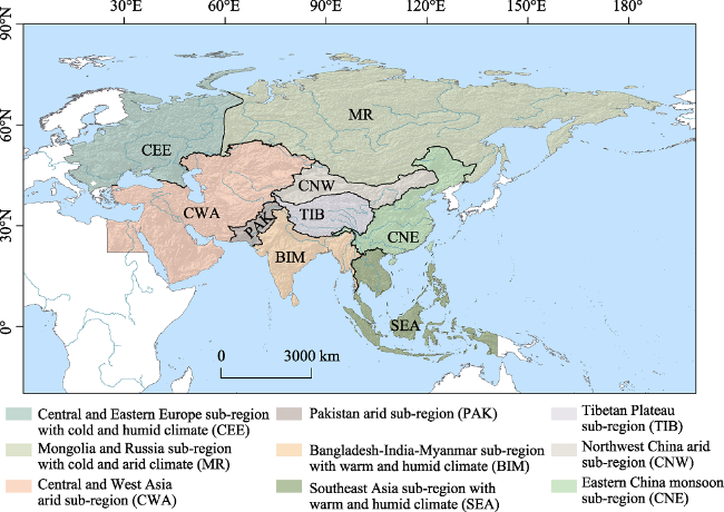
Building the Belt and Road is initiatives of China to promote win-win international cooperation in the new era, aiming at green, health, intellect and peace and the joint development with people of the countries along the route. Systematic analysis on environmental characteristics, evolutionary tendency and future risks are certainly the scientific fundamentals of sustainable development for the Belt and Road construction. Applied remote sensing monitoring, statistical analysis, this paper investigates the regional characteristics of climate, topography, soil, hydrology, vegetation cover and terrestrial ecosystems production, as well as socio-economic conditions. Based on the regional characteristics, the Belt and Road is divided into 9 sub-regions: Central and Eastern Europe sub-region with cold and humid climate, Mongolia and Russia sub-region with cold and arid climate, Central and West Asia arid sub-region, Southeast Asia sub-region with warm and humid climate, Pakistan arid sub-region, Bangladesh-India-Myanmar sub-region with warm and humid climate, Eastern China monsoon sub-region, Northwest China arid sub-region and Tibetan Plateau sub-region. Combining modeling simulation with scenario projections, natural disaster assessment methodology is used to assess the risk of extreme events including heat waves, droughts and floods in the coming 30 years (2021-2050). Results show that, on the basis of the regional framework, the western Eurasia would be a warming trend; both sides of Qinghai-Tibet Plateau in high temperature and heat waves risk; Central and Eastern Europe sub-region with cold and humid climate in high drought risk; Bangladesh-India-Myanmar sub-region with warm and humid climate as well as Eastern China in high risk of flooding.
WU Shaohong , LIU Lulu , LIU Yanhua , GAO Jiangbo , DAI Erfu , FENG Aiqing , WANG Wentao . The Belt and Road: Geographical pattern and regional risks[J]. Journal of Geographical Sciences, 2019 , 29(4) : 483 -495 . DOI: 10.1007/s11442-019-1611-4
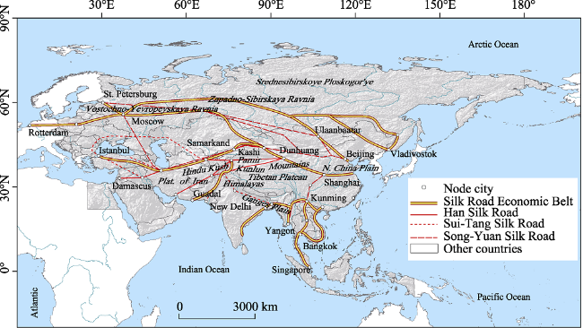
Figure 1 The covered regions and the current and historical pathways for the Belt and Road |
Table 1 The data sources for terrestrial areas of the Belt and Road |
| Index | Data source | Duration | Spatial resolution |
|---|---|---|---|
| Terrain | National Centers for Environmental Information | 2009 | 1 km |
| Soil | Harmonized World Soil Database | 2012 | 1 km |
| Land-cover | Centre for Earth System Science, Tsinghua University | 2014 | 250 m |
| Protected areas | World Database on natural reserves | 2017 | Reserve area |
| Temperature | Met Office Hadley Centre | 1950-2050 | 0.5° * 0.5° |
| Precipitation | Met Office Hadley Centre | 1950-2050 | 0.5° * 0.5° |
| SPEI | Spanish National Research Council | 1950-2004 | 0.5° * 0.5° |
| Runoff depth | Potsdam Institute for Climate Impact Research | 1971-2050 | 0.5° * 0.5° |
| NPP | Potsdam Institute for Climate Impact Research | 1971-2050 | 0.5° * 0.5° |
| Grain yield* | Global Gridded Crop Model Intercomparison | 1951-2050 | 0.5° * 0.5° |
| GDP | World Bank | 1960-2016 | Countries |
Note: *: Grain yield is the sum of rice, wheat, maize, and soybean production. |
Table 2 Classification of extreme events hazards including droughts (CI), heat waves (HI) and floods (FI) |
| Levels | Index | ||
|---|---|---|---|
| CI | HI | FI | |
| Mild | -1.8<CI≤-1.2 | 2.8≤HI<6.5 | 30(35)-150 mm |
| Moderate | -2.4<CI≤-1.8 | 6.5≤HI<10.5 | 150-250 mm |
| Severe | CI≤-2.4 | HI≥10.5 | ≥250 mm |
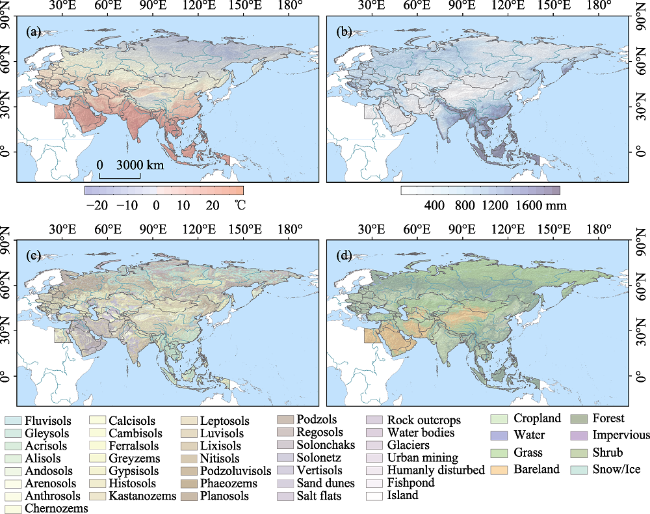
Figure 2 The spatial distribution of annual average of environmental factors (a. temperature; b. precipitation; c. soil types; and d. vegetation cover) of the Belt and Road |
Figure 3 Sub-regions of the Belt and Road |
Table 3 The covered countries or regions of the nine sub-regions of the “Belt and Road” and their environmental characteristics |
 |
Note: *: transforming from precipitation to runoff depth |
Table 4 The projected trends of different factors during 2021-2050 |
| Temperature (℃/10a) | Precipitation (mm/10a) | Runoff depth coefficient (10-3/10a) | NPP (gC·m-2/10a) | Grain yield (t·ha-1/10a) | ||||||
|---|---|---|---|---|---|---|---|---|---|---|
| RCP4.5 | RCP8.5 | RCP4.5 | RCP8.5 | RCP4.5 | RCP8.5 | RCP4.5 | RCP8.5 | RCP4.5 | RCP8.5 | |
| CEE | 0.405* | 0.305 | -0.132 | -7.83 | -1.22 | 0.14 | 17.3 | 10.0* | -0.0573 | -0.308* |
| MR | 0.725* | 0.682* | 16.1* | 8.80 | 2.82 | -0.65 | 18.9* | 24.9* | 0.122* | 0.175* |
| SEA | 0.275* | 0.422* | 16.0 | 49.9 | 3.24 | 3.26 | 15.1 | 33.8* | -0.0606 | -0.249* |
| CWA | 0.495* | 0.605* | 5.24 | -13.2* | 3.50 | 0.78 | 4.87 | -0.283* | 0.0082 | -0.200* |
| PAK | 0.476* | 0.530* | -6.00 | -17.4 | -1.22 | 5.28 | -1.20 | 4.14* | -0.321 | -0.304 |
| BIM | 0.424* | 0.582* | -5.38 | -44.8 | -0.35 | -4.71 | 5.11 | 19.7* | -0.358 | -0.424* |
| CNE | 0.352* | 0.587* | 5.49 | 18.1 | -6.12 | -2.54 | 10.5 | 28.3* | -0.0271 | 0.203 |
| CNW | 0.310* | 0.646* | 0.275 | 0.823 | -0.097 | -2.72 | 1.75 | 2.75* | -0.0146 | 0.040 |
| TIB | 0.544* | 0.585* | 0.335 | 4.18 | -0.71 | -1.18 | -0.220* | 32.0* | 0.0856* | 0.151* |
Note: *: passed the significance test of 0.05 level. |
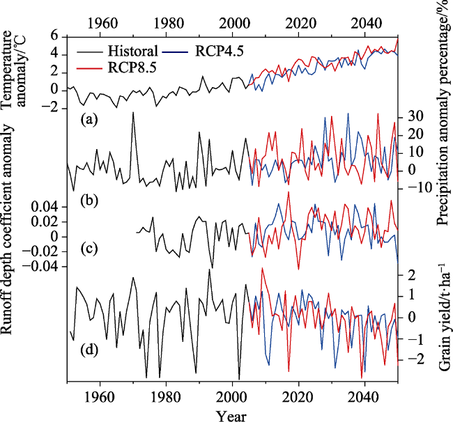
Figure 4 Annual mean changes of different resources and environment factors in typical regions (a. temperature increase in MR; b. precipitation fluctuation in SEA; c. runoff coefficients variation in CNE; d. crop yield decreases in BIM; baseline period is from 1971 to 2000) |
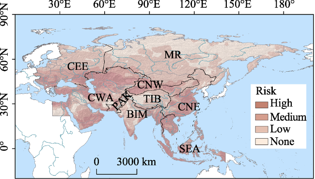
Figure 5 Heat wave hazard risks for the Belt and Road |
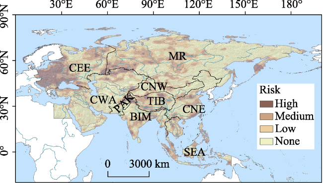
Figure 6 Drought hazard risks for the Belt and Road |
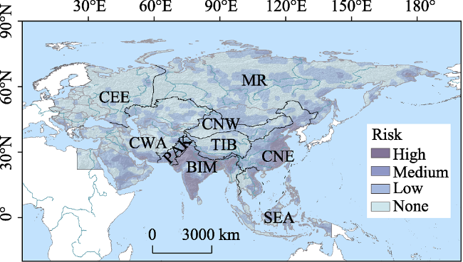
Figure 7 Flood hazard risks for the Belt and Road |
The authors have declared that no competing interests exist.
| [1] |
|
| [2] |
|
| [3] |
|
| [4] |
|
| [5] |
|
| [6] |
|
| [7] |
|
| [8] |
IPCC, 2013. Climate Change 2013: The Physical Science Basis. Contribution of Working Group I to the Fifth Assessment Report of the Intergovernmental Panel on Climate Change. Cambridge, United Kingdom and New York, USA: Cambridge University Press.
|
| [9] |
|
| [10] |
|
| [11] |
|
| [12] |
|
| [13] |
|
| [14] |
|
| [15] |
|
| [16] |
|
| [17] |
National Remote Sensing Center of China (NRSCC), Ministry of Science and Technology of the People’s Republic of China, 2015. Global Ecosystems and Environment Observation: Annual Report from China (The Belt and Road Initiative Ecological and Environmental Conditions). (in Chinese)
|
| [18] |
National Development and Reform Commission (NDRC), Ministry of Foreign Affairs, Ministry of Commerce of the People’s Republic of China, 2015. Vision and Actions on Jointly Building Silk Road Economic Belt and 21st-Century Maritime Silk Road.Finance & Accounting for Communications, (4): 82-87. (in Chinese)
|
| [19] |
|
| [20] |
|
| [21] |
|
| [22] |
|
| [23] |
|
| [24] |
|
| [25] |
|
| [26] |
|
| [27] |
|
| [28] |
|
| [29] |
|
/
| 〈 |
|
〉 |