Review Article

A review of fully coupled atmosphere-hydrology simulations

  • NING Like , 1, 2 ,
  • ZHAN Chesheng , 3, * ,
  • LUO Yong 1, 2 ,
  • WANG Yueling 3 ,
  • LIU Liangmeizi 3, 4
Expand
  • 1. Ministry of Education Key Laboratory for Earth System Modeling, Department of Earth System Science, Tsinghua University, Beijing 100084, China
  • 2. Joint Center for Global Change Studies, Beijing 100875, China
  • 3. Key Laboratory of Water Cycle and Related Land Surface Processes, Institute of Geographic Sciences and Natural Resources Research, CAS, Beijing 100101, China
  • 4. University of Chinese Academy of Sciences, Beijing 100049, China
*Corresponding author: Zhan Chesheng (1975-), Professor, E-mail:

Author: Ning Like (1986-), PhD, specialized in climate change, hydrology and water resources. E-mail:

Received date: 2018-05-18

  Accepted date: 2018-06-30

  Online published: 2019-03-20

Supported by

National Key R&D Program of China, No.2017YFA0603702

National Natural Science Foundation of China, No.41571019, No.41701023, No.41571028

China Postdoctoral Science Foundation, No.2017M610867

Copyright

Journal of Geographical Sciences, All Rights Reserved

Abstract

The terrestrial hydrological process is an essential but weak link in global/regional climate models. In this paper, the development status, research hotspots and trends in coupled atmosphere-hydrology simulations are identified through a bibliometric analysis, and the challenges and opportunities in this field are reviewed and summarized. Most climate models adopt the one-dimensional (vertical) land surface parameterization, which does not include a detailed description of basin-scale hydrological processes, particularly the effects of human activities on the underlying surfaces. To understand the interaction mechanism between hydrological processes and climate change, a large number of studies focused on the climate feedback effects of hydrological processes at different spatio-temporal scales, mainly through the coupling of hydrological and climate models. The improvement of the parameterization of hydrological process and the development of large-scale hydrological model in land surface process model lay a foundation for terrestrial hydrological-climate coupling simulation, based on which, the study of terrestrial hydrological-climate coupling is evolving from the traditional unidirectional coupling research to the two-way coupling study of “climate-hydrology” feedback. However, studies of fully coupled atmosphere-hydrology simulations (also called atmosphere-hydrology two-way coupling) are far from mature. The main challenges associated with these studies are: improving the potential mismatch in hydrological models and climate models; improving the stability of coupled systems; developing an effective scale conversion scheme; perfecting the parameterization scheme; evaluating parameter uncertainties; developing effective methodology for model parameter transplanting; and improving the applicability of models and high/super-resolution simulation. Solving these problems and improving simulation accuracy are directions for future hydro-climate coupling simulation research.

Cite this article

NING Like , ZHAN Chesheng , LUO Yong , WANG Yueling , LIU Liangmeizi . A review of fully coupled atmosphere-hydrology simulations[J]. Journal of Geographical Sciences, 2019 , 29(3) : 465 -479 . DOI: 10.1007/s11442-019-1610-5

1 Introduction

The terrestrial water cycle is an important process in the Earth system. As the effects of human activities on global climate change have become increasingly prominent, extreme hydrological events (such as floods and droughts with high frequency and duration) have increased. Simultaneously, the uncertainty in estimating the amount of water resources for ecological and economic water use and hydropower resources has also increased. The interactions and feedbacks between regional climate change and land surface hydrological processes have become one of the most essential issues in climate change and water resources research (Bates et al., 2008; IPCC, 2015). In addition, understanding the regional hydrological response process, which is jointly influenced by climate change and human activities, is one of the major strategic needs of China. The National Plan for Medium & Long-term Scientific and Technological Development states that the response of large-scale hydrological cycles to global change and the impact of global change on regional water resources is a fundamental research focus in the areas of global change and regional response. Therefore, simulations of regional climatic-terrestrial hydrology in specific basins are of great scientific significance and application value. These simulations can help understand the spatial and temporal evolution of the terrestrial water cycle in the context of global climate change; assess the impacts of climate change and human activities on the security of water resources; and safeguard the sustainable development of the economy.
Compared to global climate models, regional climate models have higher resolution and accuracy. However, the scale of regional climate models is too coarse to capture the hydrological processes of specific river basins. As traditional hydrological models mostly simulate two-dimensional or three-dimensional hydrological processes based on a homogeneous, high-resolution underlying surface, the results are more accurate than those of climate models.
Due to their different focuses, hydrological and climate models have been developed independently for a long time. However, there is an urgent need to couple climate and hydrological models to investigate the interactions and feedbacks between regional climate and land surface hydrological processes.
Since the beginning of the 21st century, the World Climate Research Program, the International Geosphere-Biosphere Program and the Global Energy and Water Cycle Experiment Program have all adopted coupled atmosphere-hydrology simulations (Liang et al., 1998). Hence, developing a large-scale water cycle simulation system that can effectively describe the spatio-temporal evolution of the water cycle and quantitatively evaluate the hydrological resources within a certain region has become an important issue in global climate change research (Guo and Liu, 1997; Yong et al., 2009).
This paper analyzes the development status, trends and hotspots in research on coupled atmosphere-hydrology simulations based on a scientific literature review. Based on a comprehensive review on the runoff scheme of land surface process model and development of large-scale water cycle model, this paper expounds on the development of atmosphere-hydrology coupling simulation from one-way coupling to two-way coupling and identifies the main problems and challenges related to the two-way coupling of atmosphere-hydrology simulation.

2 Bibliometric analysis of atmosphere-hydrology simulations

2.1 Development trends in atmosphere-hydrology simulations

To explore the trends and development of fully coupled atmosphere-hydrology simulation, we performed a topic search that aimed to capture the maximum possible amount of relevant literature using the Web of Science Core Collection, which includes the SCI and the SSCI (Social Science Citation Index) databases. We used the terms [(“climate model” OR “regional climate model” OR “land surface model” OR “land surface scheme*” OR “land surface parameterization*”) AND (“hydrology” OR “hydrolog* model” OR “hydrological cycle” OR “water cycle”)] as the search queries. A record was considered relevant if the terms were found in the keywords, title, or abstract of the publication. The queries resulted in 1617 records as of September 2016. Among these records, original research articles accounted for 96.4% (1558 records), and reviews accounted for 3.6% (59 records). Other literature types (e.g., proceedings papers and notes) were omitted from this study.
Figure 1 shows the yearly distributions of papers published and the number of cited references across their publication years based on the searched literature. It also shows that the attention paid to atmosphere-hydrology has rapidly increased in academia. The earliest cited reference year visible in Figure 1 is 1986, the earliest reference publication year is 1990, and the earliest cited reference year is 1994. The number of yearly publications increased almost 10-fold in the past 20 years. Approximately 77% of all papers were published between 2006 and 2016, suggesting exponential growth in coupled atmosphere-hydrology research.
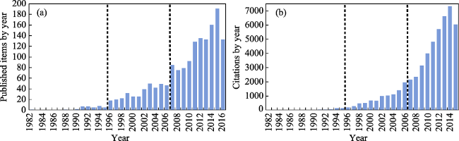
Figure 1 Published items (a) and citations (b) by year
The number of papers published per year reflects the academic input and interest in the investigation of coupled atmosphere-hydrology, and the citation frequency reflects the attention paid to the subject by academia and the public. Based on the trends in published items and citations, the development of atmosphere-hydrology research can be divided into three stages/periods as follows: (1) The embryonic stage of atmosphere-hydrology research occurred before 1996. In this stage, less than 10 papers were published each year, and the number of citations was below 150. The studies published during this period mainly focused on the parameterization of hydrological models in climate and land surface models. (2) The initial development stage of atmosphere-hydrology research occurred from 1996 to 2006. During this period, the number of papers published each year was within 50, and the number of citations was under 2000. Studies during this period mainly focused on the spatial and temporal distributions of water resources using climate models, land surface models and hydrological models. (3) The diversified stage of atmosphere-hydrology research occurs after 2006. In this stage, the amount of papers published and citation frequency increased dramatically, indicating that the topic is attracting growing attention in academia and society. In addition, the coupling of climate or land surface models with hydrological models has become increasingly relevant in this stage. Meanwhile, large-scale hydrological models and global hydrological models have seen substantial development.

2.2 Keywords of atmosphere-hydrology simulations and their distribution in major countries

As the identifiers for retrieving scientific papers, keywords can clearly express the subjects of papers and serve as key indicators of emerging trends within a field of study. In this review, 1762 unique keywords were obtained by merging and cleaning up from 1617 articles. Figure 2 shows a keywords cloud and the distribution of the top 10 keywords in primary research countries. In the keywords cloud, the size of the keyword reflects the frequency of its occurrence. The keywords cloud shows that the interactions between climate change and the hydrological cycle were studied by employing climate model/regional climate model or land surface model cooperated with hydrological model. The keywords cloud also shows that the main technical methods in our topic were remote sensing, data assimilation, error correction, and descending scale (statistical descending scale and dynamic descending scale), while the main models were General Circulation Models (GCMs), the Soil and Water Assessment Tool (SWAT), the Weather Research and Forecasting (WRF) model, Variable Infiltration Capacity (VIC) and Community Land Model (CLM). The published research focused on the impacts of climate change and human activities (including land use) on the hydrological cycle and water resources, which can be further decomposed into runoff simulation, snowmelt/thaw runoff simulation, soil moisture change, precipitation change, evapotranspiration change, groundwater change, terrestrial-atmospheric interaction, and model uncertainty evaluated by the model intercomparison plan.
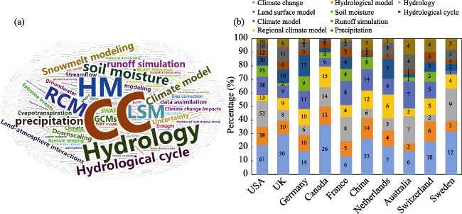
Figure 2 Keywords of published atmosphere-hydrology simulation papers (a) and their distribution in major countries (b) (CC: climate change; HM: hydrological model; LSM: land surface model)
The top ten keywords were analyzed statistically to investigate their distributions in the primary research countries. The top 10 keywords were “climate change”, “hydrological model”, “hydrology”, “regional climate model”, “land surface model”, “soil moisture”, “hydrological cycle”, “precipitation”, “climate model”, and “runoff simulation”.
The numbers in Figure 2b indicate the frequencies of the keywords. The length of the bar of each keyword represents the proportion of the keyword in related published articles in each country. The frequencies of the top ten keywords were higher in the USA than in other countries, especially for climate change, hydrological model, hydrology and land surface model. This indicates that soil water, hydrological cycle and climate model research is advanced in the USA. UK has more research on climate change and climate model over other countries. Meanwhile, the distribution of keywords is relatively uniform in Germany, where research related to land surface and hydrological models is highly developed. In Canada, research is predominantly focused on climate change, hydrological models, hydrological theory and regional climate models. Compared with other countries, research on climate change, hydrological model and regional climate model in China is in the former position. However, its research on climate models and the hydrological cycle is relatively weak and should be strengthened.

3 Foundations of coupled atmosphere-hydrology simulations: Improvement of land surface models and development of large-scale hydrological models

3.1 Improvement of land surface models

In atmosphere-hydrology simulations, the land surface model is the common interface between hydrological and atmospheric processes. Thus, accurate simulations of large-scale terrestrial water are vital to studies of atmospheric processes and climatic change. Since the simple bucket model was developed, the schemes of terrestrial hydrological processes in land surface models have been continually updated and revised (Manabe, 1969). The Project for Inter-comparison of Land-surface Parameterization Schemes, launched in the 1990s, has shown that third-generation land surface models that include remote sensing data and consider carbon cycling are improving the simulation of hydrological processes and could be used to simulate long-term changes in climate and terrestrial water resources. Representative models include the Noah land surface model (Livneh et al., 2010), the common land model (Dai et al., 2003), and the community land model (CLM) (Decker and Zeng, 2009; Oleson et al., 2010). Among them, CLM has a sub-grid structure, which is beneficial for the simulation of soil moisture and water heat flux. However, most land surface models adopt a one-dimensional, single-column structure to parameterize hydrological processes, which may worsen the accuracy of runoff simulations compared to using a hydrological model.
Table 1 summarizes some parameterization schemes used for runoff generation and river routing in land surface models. As shown in Table 1, the parameterization schemes of most land surface models remain imperfect, especially the lack of human activities in the parameterization schemes. Since most land surface models are designed with a one-dimensional, single-column structure, the simulated runoff process is mainly the response of the entire basin to precipitation, which fails to reflect the lateral movement of soil moisture and the interaction between surface water and sub-surface water. Furthermore, most of the simulated runoff is no longer involved in the related vertical water balance calculations (e.g. the recharge and evaporation of the river), which leads to some deviation when simulating land surface runoff (Sahoo et al., 2008; Ning et al., 2016; Li et al., 2017). This deviation further affects the soil moisture, thereby influencing the climate simulation (Yang et al., 2007).
Table 1 Comparison of parameterization schemes of runoff generation and river routing in land surface models
Model Runoff scheme Routing scheme Human water use
Surface Subsurface
BASE Saturation excess Gravity drainage No No
BATS Saturation excess Gravity drainage Basin aggregation of runoff Chen and Xie (2010)
BUCK Saturation excess Bucket drainage No No
CLASS Saturation excess Gravity drainage Linear reservoir cascade & unit hydrograph No
IAP94 Saturation excess Not quite clear No No
ISBA Saturation excess Gravity drainage MODCOU No
MOSAIC Saturation excess Downslope drainage No No
PLACE Infiltration excess Lateral flow and gravity drainage No No
SSIB Saturation excess Gravity drainage TOPMODEL No
UKMO Infiltration excess Gravity drainage No No
VIC-3L Saturation excess Nonlinear Arno base flow curve Unit hydrograph &
linearized St. Venant
Haddeland et al. (2006)
MATSIRO TOPMODEL Lateral flow and gravity drainage TRIP Pokhrel et al. (2012)
LaD Saturation excess Not quite clear Basin aggregation of runoff No
JULES Infiltration excess Gravity drainage No No
CLM TOPMODEL Lateral flow and gravity drainage Linear reservoir Zou et al. (2014)
Considering the importance of two-way feedbacks of atmosphere-hydrology processes, some researchers have attempted to conduct fully coupled atmosphere-hydrology simulations by inserting algorithms from hydrological models directly into land surface models to improve the hydrological process in the land surface models.
For example, Habets et al. (1999) coupled the interface-soil-biosphere-atmosphere scheme within land surface models with a large-scale hydrological model to update the surface runoff scheme. The coupled model improved the simulation of daily runoff. Seuffert et al. (2002) coupled the TOPMODEL-based land surface-atmosphere transfer scheme with a local (mesoscale) weather model. The results showed that the coupled model improved the simulation of energy flux and rainfall, although some deviations remained in the boundary layer structure. Zeng et al. (2003) replaced the hydrological process in the biosphere-atmosphere transfer scheme (BATS) by the hydrological model VXM (a combination of the VIC and Xinanjiang models) to improve the simulation of infiltration and runoff. These studies only altered an algorithm or replaced a process in the land surface model, which may result in model consistency errors and lead to the poor simulation of climatic factors other than runoff.
Some researchers have improved the modeling of hydrological processes by replacing or improving the hydrological processes systematically in climate models. These efforts can enhance the stability of the system compared to modifying a scheme separately. For example, Chen et al. (2011a, 2011b) developed the regional atmosphere-hydrology model RegHCM- TE (Regional Hydroclimate Model for the Tigris-Euphrates) based on the atmospheric model MM5 (a fifth-generation mesoscale model), a hydrological model and a snowmelt model. The results showed that RegHCM-TE can simulate regional precipitation and annual runoff well. Sheng et al. (2017) altered the runoff and river routing schemes in CLM 4.0 using the geomorphology-based hydrological model to improve runoff simulation. In addition, some studies have incorporated groundwater models into land surface models to investigate changes in groundwater (Kollet and Maxwell, 2008a; Maxwell and Miller, 2005) and base flow (Kollet and Maxwell, 2008b). However, with the continuous improvement in the description of hydrological processes in land surface models, large-scale hydrological parameterization schemes for climate simulation are emerging, and studies using algorithms in hydrological models to replace parameterization schemes in climate models are gradually decreasing (Niu et al., 2005; Vrettas and Fung, 2015).

3.2 Development of large-scale hydrological models

To estimate global and regional water resources more accurately, large-scale hydrological models based on watershed hydrological model frameworks have been developed in the past decade (Bierkens, 2015; Sood and Smakhtin, 2015) and have become one of the most important branches of climate change research (Yong et al., 2006). Based on distributed hydrological models, researchers have extended hydrological simulation from the watershed scale to the continental scale or global scale by improving the grid scale (Liu et al., 2003; Notter et al., 2007). Large-scale hydrological models are mostly based on conceptual or semi-distributed models and are primarily used to simulate runoff processes in large watersheds and to assess the impacts of climate change on hydrological situations. Table 2 lists some commonly used large-scale hydrological models, including MACRO-PDM (Arnell, 1999) and PCR-GLOBWB (Bergstrom and Graham, 1998; van Beek et al., 2011). These models simulate runoff based on the outputs of climate models, which allows the effects of climate change on water resources to be assessed in large-scale basins. However, these models are usually applied to the simulation of rainfall-runoff and the calculation of water budgets; they do not consider energy balance and cannot fully describe the water and energy exchange processes of land-atmosphere interfaces (Su and Hao, 2001).
Table 2 Comparison of parameterization schemes of some global hydrological models (Haddeland et al., 2011)
Model Forcing
variables
Energy balance ET scheme Runoff scheme Snow scheme Vegetation dynamics CO2
affected
DBH P, T, W, Q, LW, SW, SP Yes Energy balance Infiltration excess Energy balance No Constant
H08 R, S, T, W, Q, LW, SW, SP Yes Bulk formula Saturation
excess
Energy balance No No
Plum P, T, Lawn, SW No Priestley-Taylor Saturation
excess
Degree-day Yes Yes
Mac-PDM.09 P, T, W, Q, Lawn, SW No Penman-Montecito Saturation excess Degree-day No No
MATSIRO R, S, T, W, Q, LW, SW, SP Yes Bulk formula Infiltration and saturation excess Energy balance No Constant
MPI-HM P, T, W, Q, Lawn, SW, SP No Penman-Montecito Saturation excess Degree-day No No
PCR-GLOBWB P, T No Harmon Saturation excess Degree-day No No
Water GAP P, T, Lawn, SW No Priestley-Taylor Beta function Degree-day No No
WBM P,T No Harmon Beta function Empirical formula No No

R: rainfall rate, S: snowfall rate, P: precipitation rate (rain and snow calculated in the model), T: air temperature, W: wind speed, Q: air specific humidity, LW: down welling long wave radiation; Lawn: net long wave radiation; SW: down welling shortwave radiation, SP: surface pressure

In recent years, the parameterization schemes of large-scale hydrological models have been improved by incorporating energy processes, ecological processes, human activities and land use change processes. The improved models include the VIC model (Liang et al., 1994), the integrated model for global water resource assessment (Hanasaki et al., 2008) and the Integrated Hydrological Modeling System (IHMS) (Ragab and Bromley, 2010). While the improved parameterization schemes of these large-scale hydrological models reduce the gaps between the land surface models, the models still focus on the simulation of hydrological processes, and they still have some deficiencies in the simulation of biochemical processes. These drawbacks make it difficult for these models to replace land surface models in a short term. In addition, large-scale hydrological models lose some of their advantages as the scale increases to the watershed scale, and these models are mostly used for the simulation of monthly and inter-annual runoff. For watershed-scale flood simulations, researchers still use watershed hydrological models as their main tools. Therefore, to achieve the feedback between hydrological process and atmospheric process, future work should address following questions, such as how to improve the accuracy of hydrological process simulation climate model, how to optimize the coupling method.

4 Development of atmosphere-hydrology simulations from one-way coupled to fully coupled

Since the 1990s, research has focused on coupled models in the fields of atmosphere and hydrology. The simulation ability of climate models at the watershed scale has been expanded by combining the advantages of climate and hydrological models (Yu et al., 2006; Kavvas et al., 2013). Due to the importance of flood simulation and research on the impacts of climate change on water resources, coupled atmosphere-hydrology simulations have become a new topic in the IPCC technical report (IPCC, 2015).
Most studies on coupled atmosphere-hydrology models have focused on the influence of climate change on the hydrological process within a river basin, mostly using one-way coupling. The outputs of climate models (e.g. precipitation, temperature and other meteorological factors) after downscaling drive hydrological models to simulate the hydrological variables such as evapotranspiration and runoff. This one-way coupling method is easy to operate and has been widely used (Wilby and Wigley, 2000; Kruk et al., 2013; Xu et al., 2015). However, one-way coupling does not result in good simulation accuracy for hydrological processes within a certain basin because it lacks the feedback of hydrology with atmosphere. As a result, atmosphere-hydrology simulation has changed from one-way coupled simulation to fully coupled simulation. In studies on fully coupled simulation, some researchers have incorporated algorithms of runoff, infiltration and evaporation into land surface models to improve the simulation of hydrological processes.
The accuracy of runoff simulations can be improved by replacing or improving the hydrological process in the land surface model. However, this embedded coupling method is still based on the land surface model and thus cannot take advantage of the superior watershed-scale precision of hydrological models. To combine the advantages of climate and hydrological models, some researchers have fully coupled climate and hydrological models. In their methods climate models and hydrological models could be coordinated to compile and maintain their respective independence. In the coupling process, the hydrological model and the climate model exchange variables using scale conversion methods, and the hydrological model is driven by the outputs of the climate model. Hydrological variables such as evaporation and runoff are then fed to the land surface model through up-scaling methods. This method can preserve the advantages of both the climate and hydrological models and is a main development direction of future atmosphere-hydrology simulations (Peng et al., 2014; Yu and Cao, 2008).
At present, many issues remain to be solved in atmosphere-hydrology simulations. Even so, substantial research progress has been made. For example, Larsen et al. (2014) developed a fully coupled atmosphere-hydrology model for a Danish catchment by coupling the climate model HIRHAM with the hydrological model MIKE SHE. To exchange data between HIRHAM and MIKE SHE, the authors modified the MIKE SHE model using parallel algorithms to ensure the cooperative operation of HIRHAM and MIKE SHE under Linux and Windows platforms. The MIKE SHE model is driven by a bilinear interpolation of the outputs of the HIRHAM model, including surface wind speed, temperature, humidity and precipitation. The latent and sensible heat fluxes provided by MIKE SHE are fed to the atmosphere through the land surface model of the HIRHAM model. The coupled model, which keeps the advantages of both HIRHAM and MIKE SHE, can be used to simulate watershed-scale runoff using MIKE SHE along with regional climate using HIRHAM. Senatore et al. (2015) coupled the regional climate model WRF with the WRF-Hydro model to construct a fully coupled atmosphere-hydrology model and applied the model in the central Mediterranean. Wagner et al. (2016) coupled the regional climate model WRF with the distributed hydrological model HMS to develop a fully coupled mesoscale atmosphere-hydrology model. They applied the model in the Poyang Lake basin of China. Kerandi et al. (2018) used the fully coupled WRF-Hydro modeling system to investigate joint atmospheric-terrestrial water balances.
In addition, Maxwell et al. (2011) and Shrestha et al. (2014) fully coupled a climate model with a three-dimensional groundwater model to improve the runoff simulation, soil moisture and other variables in the climate model. These works retained the land surface hydrological process of the climatic model and can simulate three-dimensional groundwater movement.

5 Challenges and opportunities for future research

After years of development, the one-way coupling method of atmosphere-hydrology has been widely applied. However, fully coupled atmosphere-hydrology requires further research to improve model matching and adaptability, uncertainty assessment and so on. The focus of future development includes the following aspects.

5.1 Model matching and adaptability

The different operating platforms of hydrological models and climate models increase the difficulty associated with coupled atmosphere-hydrology simulations. Hydrological models use Windows graphical interfaces, whereas climate models adopt the parallel algorithm of the Linux system. The differences between the operating platforms make the data exchange between the hydrological and climate models more difficult. Larsen et al. (2014) made great efforts to overcome this difficulty by recompiling the hydrological model and a new coupler. Gregersen et al. (2007) developed the cross-platform coupler Open to allow data exchange between Windows and Linux platforms, providing a software approach for atmosphere-hydrology coupling. Another way to couple climate models with hydrological models is to port the hydrological model and realize its compiling under a Linux system; however, the software required for this method is difficult to realize.
In addition to the different operating platforms, modifying the hydrological process in a land surface model may cause some issues during coupling. Although the stability of the fully coupled method is much better than that of modifying a certain scheme, the water balance in the land surface model affects the energy balance, vegetation growth and other factors, which may cause the mismatch of the model system (Fiorentini et al., 2015; van Dijk et al., 2015). Therefore, in a two-way coupling study, it is necessary to evaluate the secondary changes caused by updating the water balance in the model.

5.2 Grid conversion methods among scales

Due to the mismatched resolution between the climate model and the hydrological model, the outputs of the climate models need to be downscaled, while the results of the hydrological model related to the evaporation and runoff need to upscale to match the climate model. Therefore, methods for scale transformation are a research hotspot. As different interpolation methods have their own scopes and limitations, there is no one best interpolation method (Chiew et al., 2010; Landman et al., 2009). Therefore, how to divide the grid (Bierkens et al., 2015), select the most effective scale transformation method or develop a more extensive algorithm, and reduce the deviation in simulation results caused by the heterogeneity of the grid are some of the major issues in future studies of atmosphere-hydrology coupling.

5.3 Improvement of model parameters and their uncertainty

Optimizing the physical parameterization schemes and improving the simulation precision are fundamental areas of research in atmosphere-hydrology coupling. Although considerable progress has been made in hydrological models and climate models, more attention should be given to improving the physical parameterization schemes related to the water cycle (Costa et al., 2003; Foley et al., 2005). For example, land cover and land use are relatively fixed in climate models; most models fail to consider the dynamic process of land cover/use change. At present, a few models (such as the CLM) introduce the process of dynamic vegetation growth (Lawrence and Chase, 2010). In addition to land cover/use changes, human exploitation, utilization and deployment of water resources have affected the water cycle. The interaction between human activities and global climate-hydrological processes has become a frontier issue in water resources-related research. How to parameterize the impact of human activities on water resources is a direction of land surface models and hydrological models in the future (Barnett et al., 2008; Wang et al., 2006). Improving the parameterization of vegetation biochemical processes along with frozen soil, cities, lakes and other types of underlying surfaces is also important (Luo et al., 2009; Subin et al., 2012).
Moreover, many empirical parameters in the parameterization schemes of climate models and hydrological models are uncertain in the process of real-time transfer and coupling, affecting the simulation (Benke et al., 2008; Salamon and Feyen, 2009). Quantifying the uncertainties caused by the parameters and developing methods for parameter optimization and data assimilation should help reduce the uncertainty in the parameters (Liu et al., 2012).

5.4 Parameter transfer and regional applicability

The parameter transferring approach remains difficult in hydrology, and the regional applicability of atmosphere-hydrology coupling is a key issue to be addressed. Hydrological models use statistical algorithms to describe the relationships among hydrological elements, and the simulation accuracy depends on the calibration of the model parameters. For different study basins, the hydrological model requires observation data to calibrate the parameters. Therefore, coupled atmosphere-hydrology models are usually developed for a specific watershed, and applying the models in different areas requires substantial parameter calibration and validation. Thus, applicability of coupled models on the regional scale is lacking.
Many researchers have proposed and compared numerous methods of parameter transfer to improve the applicability of hydrological models. However, the developed methods are similar to the downscaling method, and there is still no best method (Heuvelmans et al., 2004; Patil and Stieglitz, 2015). Oubeidillah et al. (2014) established a parameter dataset for the VIC model in the United States, which has made a positive contribution to the study of water resources and climate change. However, for other small-scale hydrological models, continental- or national-scale parameter datasets have not been established.

5.5 The challenge of hyper-resolution simulation

To address global or regional water cycle-related issues and application requirements more accurately under global change, developing coupled atmosphere-hydrology models with high or hyper-resolution (less than 1 km) will be a key direction for future research (Wood et al., 2011; Beven et al., 2015; Bierkens et al., 2015). The construction of land surface and hydrological models with hyper-resolution not only requires the support of supercomputers to enhance the resolution and computational capability of the model, it also faces the challenges of the mechanism of hydrological-climate interaction in the higher spatial resolution (Beven and Cloke, 2012). Therefore, how to parameterize the interaction between surface water and groundwater under the condition of vegetation and topography with the higher spatial resolution, the mechanism of terrestrial-atmosphere interaction and the spatio-temporal distribution of soil moisture and evapotranspiration under the corresponding scales are the scientific basis for the development of the hyper-resolution model. A few scholars are conducting research in this area. Singh et al. (2015) investigated the impacts of 1-km-resolution land use and soil on CLM simulation. They compared the changes in factors and processes such as runoff and infiltration compared to 100-m resolution. The results showed that the hyper-resolution description of the hydrological process greatly affected the simulation. At the same time, establishing a global observational network and a dataset of remote sensing will be an important task for the study of atmosphere-hydrology coupling with hyper-resolution.

6 Summary and concluding remarks

Due to lack of consideration of hydrological processes under different underlying surfaces in climate models, runoff simulations of climate models at a watershed scale is less accurate. Therefore, two-way atmosphere-hydrology coupling, which keeps the advantages of both hydrological and climate models, has become a key focus of climate change and water resources research.
The basis of two-way coupling is improving the hydrological process of the land surface model with the hydrological model. Conventionally, the climate model provides climate-forced input to the hydrological model through one-way coupling; however, this method lacks climate feedback from the hydrological model and will be replaced by the fully coupled method. The fully coupled method simulates hydrological processes at the watershed scale based on real-time feedback between the hydrological and climate models. The water cycle balance in the climate model is then modified accordingly.
At present, research on fully coupled atmosphere-hydrology models is not mature. Although a few works have achieved cross-platform cooperative operation between the hydrological model and the climate model, many studies need to be done, such as improving the potential mismatch in hydrological models and climate models, different scale conversion, improvement of physical process scheme of sub-grid, parameter uncertainty, parameter transfer method, region applicability and high-resolution simulation. Future research will focus on how to solve the above difficulties and improve the stability, applicability and accuracy of fully coupled models.
In view of the problems related to fully coupled atmosphere-hydrology simulation, future research will focus on atmospheric-hydrological modeling and transformation at different spatio-temporal scales; the parameterization of dynamic land cover/use change, human activities and other factors such as evapotranspiration, soil moisture, surface and groundwater under different underlying surfaces; the reduction in the mismatch and uncertainty of the model coupling process; the optimization of model parameters and parameter transfer methods for ungauged basins; and the exploration of the mechanism of atmosphere-hydrology coupling with high/hyper-resolution.

The authors have declared that no competing interests exist.

[1]
Arnell N W, 1999. A simple water balance model for the simulation of streamflow over a large geographic domain.Journal of Hydrology, 217(3/4): 314-335.http://linkinghub.elsevier.com/retrieve/pii/S0022169499000232This article describes the development, application and validation of a macro-scale hydrological model, designed to simulate streamflow from climatic inputs over a large geographic domain. The model is a daily water balance model, which assumes that the soil moisture storage capacity varies statistically across the catchment: all other catchment properties, and climatic inputs, are assumed constant across the catchment. Model parameters are derived, directly or indirectly, from digital spatial data bases. The model is currently implemented at a spatial resolution of 0.5×0.5° (approximately 2000 km ), because that is the resolution of the currently available climatic input data. In fact, the article emphasises how the form, parameterisation and quality of simulated output are strongly determined by the quality and characteristics of the data used both to define model parameters and to run the model. The article illustrates the model tuning process—which includes assessment of the input data—using the example of an application in Europe.

DOI

[2]
Barnett T P, Pierce D W, Hidalgo H Get al., 2008. Human-induced changes in the hydrology of the western United States.Science, 319(5866): 1080-1083.http://www.sciencemag.org/cgi/doi/10.1126/science.1152538Observations have shown that the hydrological cycle of the western United States changed significantly over the last half of the 20th century. We present a regional, multivariable climate change detection and attribution study, using a high-resolution hydrologic model forced by global climate models, focusing on the changes that have already affected this primarily arid region with a large and growing population. The results show that up to 60% of the climate-related trends of river flow, winter air temperature, and snow pack between 1950 and 1999 are human-induced. These results are robust to perturbation of study variates and methods. They portend, in conjunction with previous work, a coming crisis in water supply for the western United States.

DOI PMID

[3]
Bates B, Kundzewicz Z, Wu S, 2008. Climate change and water. Intergovernmental Panel on Climate Change Secretariat, Geneva.

[4]
Benke K K, Lowell K E, Hamilton A J, 2008. Parameter uncertainty, sensitivity analysis and prediction error in a water-balance hydrological model.Mathematical and Computer Modelling, 47(11/12): 1134-1149.https://linkinghub.elsevier.com/retrieve/pii/S0895717707002373Analysis of uncertainty is often neglected in the evaluation of complex systems models, such as computational models used in hydrology or ecology. Prediction uncertainty arises from a variety of sources, such as input error, calibration accuracy, parameter sensitivity and parameter uncertainty. In this study, various computational approaches were investigated for analysing the impact of parameter uncertainty on predictions of streamflow for a water-balance hydrological model used in eastern Australia. The parameters and associated equations which had greatest impact on model output were determined by combining differential error analysis and Monte Carlo simulation with stochastic and deterministic sensitivity analysis. This integrated approach aids in the identification of insignificant or redundant parameters and provides support for further simplifications in the mathematical structure underlying the model. Parameter uncertainty was represented by a probability distribution and simulation experiments revealed that the shape (skewness) of the distribution had a significant effect on model output uncertainty. More specifically, increasing negative skewness of the parameter distribution correlated with decreasing width of the model output confidence interval (i.e. resulting in less uncertainty). For skewed distributions, characterisation of uncertainty is more accurate using the confidence interval from the cumulative distribution rather than using variance. The analytic approach also identified the key parameters and the non-linear flux equation most influential in affecting model output uncertainty.

DOI

[5]
Bergstrom S, Graham L P, 1998. On the scale problem in hydrological modelling.Journal of Hydrology, 211(1-4): 253-265.http://linkinghub.elsevier.com/retrieve/pii/S0022169498002480The problem of scales and particularly the modelling of macro or continental scale catchments in hydrology is addressed. It is concluded that the magnitude of the scale problem is related to the specific hydrologic problem to be solved and to the scientific approach and perspective of the modeller. A distributed modelling approach, based on variability parameters, is suggested for modelling of soil moisture dynamics and runoff generation. It is shown that the parameters of such an approach are relatively stable over a wide range of scales. An example of the application of a standard version of the Swedish HBV hydrological model to the continental scale catchment of the Baltic Sea is shown and its usefulness is discussed.

DOI

[6]
Beven K, Cloke H, Pappenberger Fet al., 2015. Hyperresolution information and hyperresolution ignorance in modelling the hydrology of the land surface.Science China-Earth Sciences, 58(1): 25-35.http://link.springer.com/10.1007/s11430-014-5003-4There is a strong drive towards hyperresolution earth system models in order to resolve finer scales of motion in the atmosphere. The problem of obtaining more realistic representation of terrestrial fluxes of heat and water, however, is not just a problem of moving to hyperresolution grid scales. It is much more a question of a lack of knowledge about the parameterisation of processes at whatever grid scale is being used for a wider modelling problem. Hyperresolution grid scales cannot alone solve the problem of this hyperresolution ignorance. This paper discusses these issues in more detail with specific reference to land surface parameterisations and flood inundation models. The importance of making local hyperresolution model predictions available for evaluation by local stakeholders is stressed. It is expected that this will be a major driving force for improving model performance in the future.

DOI

[7]
Beven K J, Cloke H L, 2012. Comment on “Hyperresolution global land surface modeling: Meeting a grand challenge for monitoring Earth’s terrestrial water” by Eric F. Woodet al. Water Resources Research, 48(1): W01801.http://onlinelibrary.wiley.com/doi/10.1029/2010WR010090/fullMonitoring Earth’s terrestrial water conditions is critically important to manyhydrological applications such as global food production; assessing water resourcessustainability; and flood, drought, and climate change prediction. These needs havemotivated the development of pilot monitoring and prediction systems for terrestrialhydrologic and vegetative states, but to date only at the rather coarse spatial resolutions(6510–100 km) over continental to global domains. Adequately addressing critical watercycle science questions and applications requires systems that are implemented globally atmuch higher resolutions, on the order of 1 km, resolutions referred to as hyperresolution inthe context of global land surface models. This opinion paper sets forth the needs andbenefits for a system that would monitor and predict the Earth’s terrestrial water, energy,and biogeochemical cycles. We discuss six major challenges in developing a system:improved representation of surface‐subsurface interactions due to fine‐scale topographyand vegetation; improved representation of land‐atmospheric interactions and resultingspatial information on soil moisture and evapotranspiration; inclusion of water quality aspart of the biogeochemical cycle; representation of human impacts from watermanagement; utilizing massively parallel computer systems and recent computationaladvances in solving hyperresolution models that will have up to 109 unknowns; anddeveloping the required in situ and remote sensing global data sets. We deem thedevelopment of a global hyperresolution model for monitoring the terrestrial water,energy, and biogeochemical cycles a “grand challenge” to the community, and we callupon the international hydrologic community and the hydrological science supportinfrastructure to endorse the effort.

DOI

[8]
Bierkens M F P, 2015. Global hydrology 2015: State, trends, and directions.Water Resources Research, 51(7): 4923-4947.http://doi.wiley.com/10.1002/2015WR017173

DOI

[9]
Bierkens M F P, Bell V A, Burek Pet al., 2015. Hyper-resolution global hydrological modelling: What is next? “Everywhere and locally relevant”.Hydrological Processes, 29(2): 310-320.http://doi.wiley.com/10.1002/hyp.v29.2

DOI

[10]
Chen F, Xie Z H, 2010. Effects of interbasin water transfer on regional climate: A case study of the Middle Route of the South-to-North Water Transfer Project in China.Journal of Geophysical Research: Atmospheres, 115(D11): 112.http://onlinelibrary.wiley.com/doi/10.1029/2009JD012611/full[1] In this study, a water transfer mechanism was implemented into the regional climate model, RegCM3, to represent water to be transferred by increasing the precipitation that reached the surface in intake areas. The effects of interbasin water transfer on local and regional climates were then studied based on numerical simulations conducted using the RegCM3 model. The Middle Route of the South-to-North Water Transfer Project (MRSNWTP) in China was chosen as a case study to investigate the climatic responses under three different water transfer schemes with three intensities. Four 10-year simulations were conducted, a control run (MCTL) without water transfer, and three water transfer runs (MWT1, MWT2, and MWT3) related to the three schemes. In the three water transfer runs, spatial and temporal water transfer data were derived from the schemes under the assumption that the quantity of water to be transferred into a county in the intake area in a year for each scheme was distributed evenly into each time step. Increases in top-layer soil moisture and latent heat flux were observed when compared to the control, and these increases were found to occur as a direct result of injecting water into the intake area. The increases in latent heat flux and evaporation were accompanied with decreases in sensible heat flux, mean air temperature, and increases in precipitation in the intake area. These differences were generally small and statistically insignificant, indicating that the water transfer plays a small role in influencing regional climate in our simulations. However, the climatic influence intensity of a water transfer scheme was found to be positively related to the quantity of water to be transferred, and to have strong seasonal variability, with larger effect being observed in spring and autumn than in summer and winter. We also conducted a water transfer run, MWT4, using the same configuration as MWT3 but under the assumption that the quantity of water was distributed evenly into each time step of the first half of the year. Comparison of the two runs shows a stronger seasonal variability in the climatic influence when the water was assigned into the first half of the year than when it was assigned into the entire year. Further analysis revealed that the water transfer could reduce both the seasonal and diurnal temperature ranges at the surface and that the decrease in temperature could diffuse over almost the entire Huabei Plain below 700 hPa, thereby weakening the wind velocity of the easterly breeze. It follows from the analyses of the vertical profiles of the water vapor content and the atmospheric moisture budgets that the water transfer can affect the local and regional climates by changing the local water vapor content and the regional water vapor transports, which in turn influences precipitation.

DOI

[11]
Chen Z Q R, Kavvas M L, Ohara Net al., 2011a. Coupled regional hydroclimate model and its application to the Tigris-Euphrates Basin.Journal of Hydrologic Engineering, 16(12): 1059-1070.http://ascelibrary.org/doi/10.1061/%28ASCE%29HE.1943-5584.0000207

DOI

[12]
Chen Z Q R, Kavvas M L, Ohara Net al., 2011b. Impact of water resources utilization on the hydrology of mesopotamian marshlands.Journal of Hydrologic Engineering, 16(12): 1083-1092.http://ascelibrary.org/doi/10.1061/%28ASCE%29HE.1943-5584.0000208

DOI

[13]
Chiew F H S, Kirono D G C, Kent D Met al., 2010. Comparison of runoff modelled using rainfall from different downscaling methods for historical and future climates.Journal of Hydrology, 387(1/2): 10-23.https://linkinghub.elsevier.com/retrieve/pii/S0022169410001514This paper: (i) assesses the rainfall downscaled from three global climate models (GCMs) using five downscaling models, (ii) assesses the runoff modelled by the SIMHYD rainfall unoff model using the downscaled daily rainfall, and (iii) compares the modelled changes in future rainfall and runoff characteristics. The modelling study is carried out using rainfall and streamflow data from eight unimpaired catchments near the headwaters of the Murray River in south-east Australia. The downscaling models used, in increasing order of complexity, are a daily scaling model, an analogue statistical downscaling model, GLIMCLIM and NHMM parametric statistical downscaling models, and CCAM dynamic downscaling model. All the downscaling models can generally reproduce the observed historical rainfall characteristics. The rainfall unoff modelling using downscaled rainfall also generally reproduces the observed historical runoff characteristics. The future simulations are most similar between the daily scaling, analogue and NHMM models, all of them simulating a drier future. The GLIMCLIM and CCAM models simulate a smaller decrease in future rainfall. The differences between the modelled future runoff using the different downscaled rainfall can be significant, and this needs to be further investigated in the context of projections from a large range of GCMs and different hydrological models and applications. The simpler to apply daily scaling and analogue models (they also directly provide gridded rainfall inputs) can be relatively easily used for impact assessments over very large regions. The parametric downscaling models offer potential improvements as they capture a fuller range of daily rainfall characteristics.

DOI

[14]
Costa M H, Botta A, Cardille J A, 2003. Effects of large-scale changes in land cover on the discharge of the Tocantins River, Southeastern Amazonia.Journal of Hydrology, 283(1-4): 206-217.https://linkinghub.elsevier.com/retrieve/pii/S0022169403002671Studies that relate changes in land cover with changes in river discharge at the small scale (<1 km 2) are abundant. These studies generally indicate that deforestation causes an increase in the annual mean discharge. However, previous studies that evaluated the effects of changes in land cover in larger river basins (>100 km 2) usually have not found similar relationships. Here we analyse a 50-year long time series of discharge of a tropical river, the Tocantins River at Porto Nacional (175,360 km 2), as well as precipitation over this drainage area, during a period where substantial changes in land cover occurred in the basin (1949–1998). Based on agricultural census data, we estimate that, in 1960, about 30% of the basin was used for agriculture. Previous work indicates that by 1995, agriculture had increased substantially, with about 49% of the basin land used as cropland and pastures. Initially, we compare one period with little changes in land cover (period 1-1949–1968) with another with more intense changes in land cover (period 2-1979–1998). Our analysis indicates that, while precipitation over the basin is not statistically different between period 1 and period 2 ( α=0.05), annual mean discharge in period 2 is 24% greater than in period 1 ( P<0.02), and the high-flow season discharge is greater by 28% ( P<0.01). Further analyses present additional evidence that the change in vegetation cover altered the hydrological response of this region. As the pressure for changes in land cover in that region continue to increase, one can expect important further changes in the hydrological regime of the Tocantins River.

DOI

[15]
Dai Y J, Zeng X B, Dickinson R Eet al., 2003. The common land model.Bulletin of the American Meteorological Society, 84(8): 1013-1023.http://journals.ametsoc.org/doi/10.1175/BAMS-84-8-1013

DOI

[16]
Decker M, Zeng X B, 2009. Impact of modified richards equation on global soil moisture simulation in the Community Land Model (CLM3.5).Journal of Advances in Modeling Earth Systems, 1(3): 22.http://onlinelibrary.wiley.com/doi/10.3894/JAMES.2009.1.5/citedby[1] A fundamental deficiency has been found in the numerical solution of the soil moisture-based Richards equation using the mass-conservative scheme in the Community Land Model (CLM) in the first part of our efforts (Zeng and Decker 2009). This study implements the revised form of the Richards equation from that study (which doesn't change the property of the differential equation but does remove the deficiency of the numerical solution) along with a new bottom boundary condition into the current version of CLM (CLM3.5) for global offline modeling evaluations. CLM3.5 represents a significant improvement over its earlier version (CLM3.0), but it also introduces a new deficiency in the vertical distribution of the soil moisture variability. Mean soil moisture in CLM3.5 is also too wet. It is found that the new treatments (primarily a numerically correct solution of Richards equation with a new bottom boundary condition) with minimal tuning are able to maintain the improvements of the CLM3.5 over CLM3.0 and, at the same time, remove the new deficiencies of CLM3.5 based on in situ and satellite data analysis. Because the deficiency in the numerical solution of the soil moisture-based Richards equation is also expected in other land models, implementation details are provided to facilitate similar tests using other land models in the future.

DOI

[17]
Fiorentini M, Orlandini S, Paniconi C, 2015. Control of coupling mass balance error in a process-based numerical model of surface-subsurface flow interaction.Water Resources Research, 51(7): 5698-5716.http://doi.wiley.com/10.1002/2014WR016816Abstract A process-based numerical model of integrated surface-subsurface flow is analyzed in order to identify, track, and reduce the mass balance errors affiliated with the model's coupling scheme. The sources of coupling error include a surface-subsurface grid interface that requires node-to-cell and cell-to-node interpolation of exchange fluxes and ponding heads, and a sequential iterative time matching procedure that includes a time lag in these same exchange terms. Based on numerical experiments carried out for two synthetic test cases and for a complex drainage basin in northern Italy, it is shown that the coupling mass balance error increases during the flood recession limb when the rate of change in the fluxes exchanged between the surface and subsurface is highest. A dimensionless index that quantifies the degree of coupling and a saturated area index are introduced to monitor the sensitivity of the model to coupling error. Error reduction is achieved through improvements to the heuristic procedure used to control and adapt the time step interval and to the interpolation algorithm used to pass exchange variables from nodes to cells. The analysis presented illustrates the trade-offs between a flexible description of surface and subsurface flow processes and the numerical errors inherent in sequential iterative coupling with staggered nodal points at the land surface interface, and it reveals mitigation strategies that are applicable to all integrated models sharing this coupling and discretization approach.

DOI

[18]
Foley J A, DeFries R, Asner G Pet al., 2005. Global consequences of land use.Science, 309(5734): 570-574.http://www.sciencemag.org/cgi/doi/10.1126/science.1111772

DOI

[19]
Gregersen J B, Gijsbers P J A, Westen S J P, 2007. OpenMI: Open modelling interface.Journal of Hydroinformatics, 9(3): 175-191.https://iwaponline.com/jh/article/9/3/175-191/3096

DOI

[20]
Guo S, Liu C, 1997. Large scale hydrological models and its coupling with atmospheric models.Journal of Hydraulic Engineering, 7: 37-41. (in Chinese)

[21]
Habets F, Noilhan J, Golaz Cet al., 1999. The ISBA surface scheme in a macroscale hydrological model applied to the Hapex-Mobilhy area (Part II): Simulation of streamflows and annual water budget.Journal of Hydrology, 217(1/2): 97-118.http://linkinghub.elsevier.com/retrieve/pii/S0022169499000207

DOI

[22]
Haddeland I, Clark D B, Franssen Wet al., 2011. Multimodel estimate of the global terrestrial water balance: Setup and first results.Journal of Hydrometeorology, 12(5): 869-884.http://journals.ametsoc.org/doi/abs/10.1175/2011JHM1324.1

DOI

[23]
Haddeland I, Skaugen T, Lettenmaier D P, 2006. Anthropogenic impacts on continental surface water fluxes.Geophysical Research Letters, 33(8): L08406.http://onlinelibrary.wiley.com/doi/10.1029/2006GL026047/fullImpacts of reservoirs and irrigation water withdrawals on continental surface water fluxes are studied within the framework of the Variable Infiltration Capacity (VIC) model for a part of North America, and for Asia. A reservoir model, designed for continental-scale simulations, is developed and implemented in the VIC model. The model successfully simulates irrigation water requirements, and captures the main effects of reservoir operations and irrigation water withdrawals on surface water fluxes, although consumptive irrigation water use is somewhat underestimated. For the North American region, simulated irrigation water requirements and consumptive irrigation water uses are 191 and 98 kmyear, while the corresponding numbers for the Asian region are 810 and 509 kmyear, respectively. The consumptive uses represent a decrease in river discharge of 4.2 percent for the North American region, and 2.8 percent for the Asian region. The largest monthly decrease is about 30 percent, for the area draining the Western USA in June. The maximum monthly increase in streamflow (28 percent) is in March for the Asian Arctic region.

DOI

[24]
Hanasaki N, Kanae S, Oki Tet al., 2008. An integrated model for the assessment of global water resources (Part 1): Model description and input meteorological forcing.Hydrology and Earth System Sciences, 12(4): 1007-1025.http://www.hydrol-earth-syst-sci.net/12/1007/2008/To assess global water availability and use at a subannual timescale, an integrated global water resources model was developed consisting of six modules: land surface hydrology, river routing, crop growth, reservoir operation, environmental flow requirement estimation, and anthropogenic water withdrawal. The model simulates both natural and anthropogenic water flow globally (excluding Antarctica) on a daily basis at a spatial resolution of 1 1 (longitude and latitude). This first part of the two-feature report describes the six modules and the input meteorological forcing. The input meteorological forcing was provided by the second Global Soil Wetness Project (GSWP2), an international land surface modeling project. Several reported shortcomings of the forcing component were improved. The land surface hydrology module was developed based on a bucket type model that simulates energy and water balance on land surfaces. The crop growth module is a relatively simple model based on concepts of heat unit theory, potential biomass, and a harvest index. In the reservoir operation module, 452 major reservoirs with >1 km3 each of storage capacity store and release water according to their own rules of operation. Operating rules were determined for each reservoir by an algorithm that used currently available global data such as reservoir storage capacity, intended purposes, simulated inflow, and water demand in the lower reaches. The environmental flow requirement module was newly developed based on case studies from around the world. Simulated runoff was compared and validated with observation-based global runoff data sets and observed streamflow records at 32 major river gauging stations around the world. Mean annual runoff agreed well with earlier studies at global and continental scales, and in individual basins, the mean bias was less than 20% in 14 of the 32 river basins and less than 卤50% in 24 basins. The error in the peak was less than 卤1 mo in 19 of the 27 basins and less than 2 mo in 25 basins. The performance was similar to the best available precedent studies with closure of energy and water. The input meteorological forcing component and the integrated model provide a framework with which to assess global water resources, with the potential application to investigate the subannual variability in water resources.

DOI

[25]
Heuvelmans G, Muys B, Feyen J, 2004. Evaluation of hydrological model parameter transferability for simulating the impact of land use on catchment hydrology.Physics and Chemistry of the Earth, 29(11/12): 739-747.https://linkinghub.elsevier.com/retrieve/pii/S1474706504001068During the past decades, the use of hydrological models for predicting the impact of land use on catchment hydrology increased considerably. The performance of those models is often judged by a simple split-sample test using historical discharge series. The derived parameter values are then assumed to be identical for the new land use scenario, apart from the crop and management characteristics that are adapted to the land use under study. This paper checks the validity of this assumption in an indirect way, by evaluating the transferability of the main controlling parameters of the semi-distributed SWAT model in a stepwise fashion: within the catchment, a neighbouring catchment and a catchment under a different environmental setting. The results indicate that there is a decline in model performance when parameters are transferred in time and space. Transfer within the catchment and to a neighbouring catchment gives for the case study still a reasonable performance, yet one should be careful when exchanging parameter values between regions with a different topography, soil and land use. These factors might influence the infiltration and percolation of water and so affect the associated model parameters.

DOI

[26]
IPCC, 2015. Climate Change 2014: Mitigation of Climate Change. Vol. 3. Cambridge: Cambridge University Press.

[27]
Kavvas M L, Kure S, Chen Z Qet al., 2013. WEHY-HCM for modeling interactive atmospheric-hydrologic processes at watershed scale. I: Model description.Journal of Hydrologic Engineering, 18(10): 1262-1271.http://ascelibrary.org/doi/10.1061/%28ASCE%29HE.1943-5584.0000724Among the key problems in atmospheric and hydrologic sciences are the modeling of the interaction between the atmosphere and land surface hydrology while also quantifying the surface/subsurface hydrologic flow processes both in vertical and lateral directions, and modeling the heterogeneity in surface and subsurface hydrologic processes. Meanwhile, in standard water resources engineering practice, the planning and management of the water resources is performed over the geographical region of a watershed. To address these issues, a model of coupled atmospheric-hydrologic processes at the watershed scale, the Watershed Environmental Hydrology Hydro-Climate Model (WEHY-HCM), has been developed. The atmospheric model PSU/NCAR MM5 (Fifth Generation Mesoscale Model) was coupled to the watershed hydrology model WEHY through the atmospheric boundary layer to form the WEHY-HCM. The WEHY-HCM is especially useful for producing nonexistent atmospheric data as input to the modeling of surface and subsurface hydrologic processes at sparsely gauged or ungauged watersheds. The continuously changing state of the atmospheric boundary layer may be essential information in the computation of evapotranspiration (ET) rates and other land surface fluxes. Because such land surface fluxes are the result of the interaction of land surface hydrologic processes with atmospheric processes, their realistic estimation necessitates the coupled modeling of these processes, as is done in the WEHY-HCM. The model is also useful at watersheds that have heterogeneous topography and land use/cover because the main model components are based on areally averaged, scalable conservation equations and parameters in order to quantify and account for the effect of heterogeneity within watersheds. In this paper, the modeling of an integrated system of atmospheric processes aloft coupled with atmospheric boundary layer processes, land surface processes, and surface and subsurface hydrologic processes is described at the scale of a watershed within the framework of WEHY-HCM.

DOI

[28]
Kerandi N, Arnault J, Laux Pet al., 2018. Joint atmospheric-terrestrial water balances for East Africa: A WRF-Hydro case study for the upper Tana River basin.Theoretical and Applied Climatology, 131(3): 1337-1355.http://link.springer.com/10.1007/s00704-017-2050-8For an improved understanding of the hydrometeorological conditions of the Tana River basin of Kenya, East Africa, its joint atmospheric-terrestrial water balances are investigated. This is achieved through the application of the Weather Research and Forecasting (WRF) and the fully coupled WRF-Hydro modeling system over the Mathioya-Sagana subcatchment (3279 km) and its surroundings in the upper Tana River basin for 4 years (2011-2014). The model setup consists of an outer domain at 25 km (East Africa) and an inner one at 5-km (Mathioya-Sagana subcatchment) horizontal resolution. The WRF-Hydro inner domain is enhanced with hydrological routing at 500-m horizontal resolution. The results from the fully coupled modeling system are compared to those of the WRF-only model. The coupled WRF-Hydro slightly reduces precipitation, evapotranspiration, and the soil water storage but increases runoff. The total precipitation from March to May and October to December for WRF-only (974 mm/year) and coupled WRF-Hydro (940 mm/year) is closer to that derived from the Climate Hazards Group Infrared Precipitation with Stations (CHIRPS) data (989 mm/year) than from the TRMM (795 mm/year) precipitation product. The coupled WRF-Hydro-accumulated discharge (323 mm/year) is close to that observed (333 mm/year). However, the coupled WRF-Hydro underestimates the observed peak flows registering low but acceptable NSE (0.02) and RSR (0.99) at daily time step. The precipitation recycling and efficiency measures between WRF-only and coupled WRF-Hydro are very close and small. This suggests that most of precipitation in the region comes from moisture advection from the outside of the analysis domain, indicating a minor impact of potential land-precipitation feedback mechanisms in this case. The coupled WRF-Hydro nonetheless serves as a tool in quantifying the atmospheric-terrestrial water balance in this region.

DOI

[29]
Kollet S J, Maxwell R M, 2008a. Capturing the influence of groundwater dynamics on land surface processes using an integrated, distributed watershed model.Water Resources Research, 44(2): W02402.http://onlinelibrary.wiley.com/doi/10.1029/2007WR006004/fullThe influence of groundwater dynamics on the energy balance at the land surface is studied using an integrated, distributed watershed modeling platform. This model includes the mass and energy balance at the land surface; three-dimensional variably saturated subsurface flow; explicit representation of the water table; and overland flow. The model is applied to the Little Washita watershed in Central Oklahoma, USA and compared to runoff, soil moisture and energy flux observations. The connection between groundwater dynamics and the land surface energy balance is studied using a variety of conventional and spatial statistical measures. For a number of energy variables a strong interconnection is demonstrated with water table depth. This connection varies seasonally and spatially depending on the spatial composition of water table depth. A theoretical critical water table depth range is presented where a strong sensitivity between groundwater and land-surface processes may be observed. For this particular watershed, a critical depth range is established between 1 and 5 m in which the land surface energy budget is most sensitive to groundwater storage. Finally, concrete recommendations are put forth to characterize this interconnection in the field.

DOI

[30]
Kollet S J, Maxwell R M, 2008b. Demonstrating fractal scaling of baseflow residence time distributions using a fully-coupled groundwater and land surface model.Geophysical Research Letters, 35(7): L07402.http://adsabs.harvard.edu/abs/2008GeoRL..35.7402KThe influence of the vadose zone, land surface processes, and macrodispersion on the shape and scaling behavior of residence time distributions of baseflow is studied using a fully coupled watershed model in conjunction with a Lagrangian, particle-tracking approach. Numerical experiments are used to simulate groundwater flow paths from recharge locations along the hillslope to the streambed. These experiments are designed to isolate the influences of topography, vadose zone/land surface processes, and macrodispersion on subsurface transport of tagged parcels of water. The results of these simulations agree with previous observations that such distributions exhibit a power law form and fractal behavior, which can be identified from plots of the residence time distribution and the power spectra. It is shown that vadose zone/land surface processes significantly affect both the residence time distributions and their spectra.

DOI

[31]
Kruk N S, Vendrame I F, Chou S C, 2013. Coupling a mesoscale atmospheric model with a distributed hydrological model applied to a watershed in Southeast Brazil.Journal of Hydrologic Engineering, 18(1): 58-65.http://ascelibrary.org/doi/10.1061/%28ASCE%29HE.1943-5584.0000606

DOI

[32]
Landman W A, Kgatuke M J, Mbedzi Met al., 2009. Performance comparison of some dynamical and empirical downscaling methods for South Africa from a seasonal climate modelling perspective.International Journal of Climatology, 29(11): 1535-1549.http://doi.wiley.com/10.1002/joc.v29%3A11The ability of advanced state-of-the-art methods of downscaling large-scale climate predictions to regional and local scale as seasonal rainfall forecasting tools for South Africa is assessed. Various downscaling techniques and raw general circulation model (GCM) output are compared to one another over 10 December-January-February (DJF) seasons from 1991/1992 to 2000/2001 and also to a baseline prediction technique that uses only global sea-surface temperature (SST) anomalies as predictors. The various downscaling techniques described in this study include both an empirical technique called model output statistics (MOS) and a dynamical technique where a finer resolution regional climate model (RCM) is nested into the large-scale fields of a coarser GCM. The study addresses the performance of a number of simulation systems (no forecast lead-time) of varying complexity. These systems' performance is tested for both homogeneous regions and for 963 stations over South Africa, and compared with each other over the 10-year test period. For the most part, the simulations method outscores the baseline method that uses SST anomalies to simulate rainfall, therefore providing evidence that current approaches in seasonal forecasting are outscoring earlier ones. Current operational forecasting approaches involve the use of GCMs, which are considered to be the main tool whereby seasonal forecasting efforts will improve in the future. Advantages in statistically post-processing output from GCMs as well as output from RCMs are demonstrated. Evidence is provided that skill should further improve with an increased number of ensemble members. The demonstrated importance of statistical models in operation capacities is a major contribution to the science of seasonal forecasting. Although RCMs are preferable due to physical consistency, statistical models are still providing similar or even better skill and should still be applied. Copyright 2008 Royal Meteorological Society

DOI

[33]
Larsen M A D, Refsgaard J C, Drews Met al., 2014. Results from a full coupling of the HIRHAM regional climate model and the MIKE SHE hydrological model for a Danish catchment.Hydrology and Earth System Sciences, 18(11): 4733-4749.https://www.hydrol-earth-syst-sci.net/18/4733/2014/A major challenge in the emerging research field of coupling of existing regional climate models (RCMs) and hydrology/land-surface models is the computational interaction between the models. Here we present results from a full two-way coupling of the HIRHAM RCM over a 4000 km ?? 2800 km domain at 11 km resolution and the combined MIKE SHE-SWET hydrology and land-surface models over the 2500 km2 Skjern River catchment. A total of 26 one-year runs were performed to assess the influence of the data transfer interval (DTI) between the two models and the internal HIRHAM model variability of 10 variables. DTI frequencies between 12 and 120 min were assessed, where the computational overhead was found to increase substantially with increasing exchange frequency. In terms of hourly and daily performance statistics the coupled model simulations performed less accurately than the uncoupled simulations, whereas for longer-term cumulative precipitation the opposite was found, especially for more frequent DTI rates. Four of six output variables from HIRHAM, precipitation, relative humidity, wind speed and air temperature, showed statistically significant improvements in root-mean-square error (RMSE) by reducing the DTI. For these four variables, the HIRHAM RMSE variability corresponded to approximately half of the influence from the DTI frequency and the variability resulted in a large spread in simulated precipitation. Conversely, DTI was found to have only a limited impact on the energy fluxes and discharge simulated by MIKE SHE.

DOI

[34]
Lawrence P J, Chase T N, 2010. Investigating the climate impacts of global land cover change in the community climate system model.International Journal of Climatology, 30(13): 2066-2087.http://doi.wiley.com/10.1002/joc.v30%3A13Recently, (Pitman et al., 2009) found a wide range of bio-geophysical climate impacts from historical land cover change when modelled in a suite of current global climate models (GCMs). The bio-geophysical climate impacts of human land cover change, however, have been investigated by a wide range of general circulation modelling, regional climate modelling, and observational studies. In this regard the IPCC 4th assessment report specifies radiative cooling of 0.2 W/m2 as the dominant global impact of human land cover change since 1750, but states this has a low to medium level of scientific understanding. To further contribute to the understanding of the possible climatic impacts of anthropogenic land cover change, we have performed a series of land cover change experiments with the community land model (CLM) within the community climate system model (CCSM). To do this we have developed a new set of potential vegetation land surface parameters to represent land cover change in CLM. The new parameters are consistent with the potential vegetation biome mapping of (Ramankutty and Foley, 1999), with the plant functional types (PFTs) and plant phenology consistent with the current day Moderate Resolution Imaging Spectroradiometer (MODIS) land surface parameters of (Lawrence and Chase, 2007). We found that land cover change in CCSM resulted in widespread regional warming of the near surface atmosphere, but with limited global impact on near surface temperatures. The experiments also found changes in precipitation, with drier conditions regionally, but with limited impact on average global precipitation. Analysis of the surface fluxes in the CCSM experiments found the current day warming was predominantly driven by changes in surface hydrology through reduced evapo-transpiration and latent heat flux, with the radiative forcing playing a secondary role. We show that these finding are supported by a wide range of observational field studies, satellite studies and regional and global climate modelling studies. Copyright 2010 Royal Meteorological Society

DOI

[35]
Li M X, Ma Z G, Lv M X, 2017. Variability of modeled runoff over China and its links to climate change.Climatic Change, 144(3): 433-445.http://link.springer.com/10.1007/s10584-015-1593-xRunoff is a key component of the water cycle over land, with direct impact on regional ecosystems and water resources. This study investigates historical runoff variability and change over China in 19

DOI

[36]
Liang X, Lettenmaier D P, Wood E Fet al., 1994. A simple hydrologically based model of land-surface water and energy fluxes for general-circulation models.Journal of Geophysical Research-Atmospheres, 99(D7): 14415-14428.http://doi.wiley.com/10.1029/94JD00483

DOI

[37]
Liang X, Wood E F, Lettenmaier D Pet al., 1998. The Project for Intercomparison of Land-surface Parameterization Schemes (PILPS) phase 2(c) Red-Arkansas River basin experiment: 2. Spatial and temporal analysis of energy fluxes.Global and Planetary Change, 19(1-4): 137-159.http://linkinghub.elsevier.com/retrieve/pii/S0921818198000459The energy components of sixteen Soil-Vegetation Atmospheric Transfer (SVAT) schemes were analyzed and intercompared using 10 years of surface meteorological and radiative forcing data from the Red-Arkansas River basin in the Southern Great Plains of the United States. Comparisons of simulated surface energy fluxes among models showed that the net radiation and surface temperature generally had the best agreement among the schemes. On an average (annual and monthly) basis, the estimated latent heat fluxes agreed (to within approximate estimation errors) with the latent heat fluxes derived from a radiosonde-based atmospheric budget method for slightly more than half of the schemes. The sensible heat fluxes had larger differences among the schemes than did the latent heat fluxes, and the model-simulated ground heat fluxes had large variations among the schemes. The spatial patterns of the model-computed net radiation and surface temperature were generally similar among the schemes, and appear reasonable and consistent with observations of related variables, such as surface air temperature. The spatial mean patterns of latent and sensible heat fluxes were less similar than for net radiation, and the spatial patterns of the ground heat flux vary greatly among the 16 schemes. Generally, there is less similarity among the models in the temporal (interannual) variability of surface fluxes and temperature than there is in the mean fields, even for schemes with similar mean fields.

DOI

[38]
Liu C, Li D, Tian Yet al., 2003. An application study of dem based distributed hydrological model on macroscale watershed.Progress in Geography, 22(5): 437-445. (in Chinese)

[39]
Liu Y, Weerts A H, Clark Met al., 2012. Advancing data assimilation in operational hydrologic forecasting: Progresses, challenges, and emerging opportunities.Hydrology and Earth System Sciences, 16(10): 3863-3887.https://www.hydrol-earth-syst-sci.net/16/3863/2012/

DOI

[40]
Livneh B, Xia Y L, Mitchell K Eet al., 2010. Noah LSM snow model diagnostics and enhancements.Journal of Hydrometeorology, 11(3): 721-738.http://journals.ametsoc.org/doi/abs/10.1175/2009JHM1174.1A negative snow water equivalent (SWE) bias in the snow model of the Noah land surface scheme used in the NCEP suite of numerical weather and climate prediction models has been noted by several investigators. This bias motivated a series of offline tests of model extensions and improvements intended to reduce or eliminate the bias. These improvements consist of changes to the model's albedo for...

DOI

[41]
Luo S Q, Lu S H, Zhang Y, 2009. Development and validation of the frozen soil parameterization scheme in Common Land Model.Cold Regions Science and Technology, 55(1): 130-140.https://linkinghub.elsevier.com/retrieve/pii/S0165232X08001122In this paper, a frozen soil parameterization scheme is developed based on the Common Land Model. We modify a frozen soil parameterization scheme using soil matric potential to define maximum liquid water content when soil temperature is below the freezing point; the simulation performance is validated using the data from Maqu station on the Tibetan Plateau from 2005 to 2006. The simulated results indicate that the modified frozen soil parameterization scheme allows the liquid water to exist when the soil temperature is below the freezing point, and the simulated soil liquid water content is significantly improved. The simulated soil temperature is also improved because of the successful simulation of the soil liquid water content. The distribution of energy from the modified model is closer to the observed data. Also, the simulated latent heat flux from the modified model increases and the simulated soil heat flux descends compared with the original model.

DOI

[42]
Manabe S, 1969. Climate and the ocean circulation: I. The atmospheric circulation and the hydrology of the earth’s surface.Monthly Weather Review, 97(11): 739-774.http://journals.ametsoc.org/doi/abs/10.1175/1520-0493%281969%29097%3C0739%3ACATOC%3E2.3.CO%3B2

DOI

[43]
Maxwell R M, Lundquist J K, Mirocha J Det al., 2011. Development of a coupled groundwater-atmosphere model.Monthly Weather Review, 139(1): 96-116.http://journals.ametsoc.org/doi/abs/10.1175/2010MWR3392.1Complete models of the hydrologic cycle have gained recent attention as research has shown interdependence between the coupled land and energy balance of the subsurface, land surface, and lower atmosphere. PF.WRF is a new model that is a combination of the Weather Research and Forecasting (WRF) atmospheric model and a parallel hydrology model (ParFlow) that fully integrates three-dimensional, variably saturated subsurface flow with overland flow. These models are coupled in an explicit, operator-splitting manner via the Noah land surface model (LSM). Here, the coupled model formulation and equations are presented and a balance of water between the subsurface, land surface, and atmosphere is verified. The improvement in important physical processes afforded by the coupled model using a number of semi-idealized simulations over the Little Washita watershed in the southern Great Plains is demonstrated. These simulations are initialized with a set of offline spinups to achieve a balanced state of initial conditions. To quantify the significance of subsurface physics, compared with other physical processes calculated in WRF, these simulations are carried out with two different surface spinups and three different microphysics parameterizations in WRF. These simulations illustrate enhancements to coupled model physics for two applications: water resources and wind-energy forecasting. For the water resources example, it is demonstrated how PF.WRF simulates explicit rainfall and water storage within the basin and runoff. Then the hydrographs predicted by different microphysics schemes within WRF are compared. Because soil moisture is expected to impact boundary layer winds, the applicability of the model to wind-energy applications is demonstrated by using PF.WRF and WRF simulations to provide estimates of wind and wind shear that are useful indicators of wind-power output.

DOI

[44]
Maxwell R M, Miller N L, 2005. Development of a coupled land surface and groundwater model.Journal of Hydrometeorology, 6(3): 233-247.http://journals.ametsoc.org/doi/abs/10.1175/JHM422.1Traditional land surface models (LSMs) used for numerical weather simulation, climate projection, and as inputs to water management decision support systems. do not treat the LSM lower boundary in a fully process-based fashion. LSMs have evolved from a leaky-bucket approximation to more sophisticated land surface water and energy budget models that typically have a specified bottom layer flux to depict the lowest model layer exchange with deeper aquifers. The LSM lower boundary is often assumed zero flux or the soil moisture content is set to a constant value; an approach that while mass conservative, ignores processes that can alter surface fluxes, runoff, and water quantity and quality. Conversely, groundwater models (GWMs) for saturated and unsaturated water flow, while addressing important features such as subsurface heterogeneity and three-dimensional flow, often have overly simplified upper boundary conditions that ignore soil heating. runoff, snow, and root-zone uptake. In the present study, a state-of-the-art LSM (Common Land Model) and a variably saturated GWM (ParFlow) have been coupled as a single-column model. A set of simulations based on synthetic data and data from the Project for Intercomparison of Land-surface Parameterization Schemes (PILPS), version 2(d), 18-yr dataset from VaIdai, Russia, demonstrate the temporal dynamics of this coupled modeling system. The soil moisture and water table depth simulated by the coupled model agree well with the Valdai observations. Differences in prediction between the coupled and uncoupled models demonstrate the effect of a dynamic water table on simulated watershed flow. Comparison of the coupled model predictions with observations indicates certain cold processes such as frozen soil and freeze/thaw processes have an important impact on predicted water table depth. Comparisons of soil moisture, latent heat, sensible heat. temperature, runoff, and predicted groundwater depth between the uncoupled and coupled models demonstrate the need for improved groundwater representation in land surface schemes.

DOI

[45]
Ning L K, Xia J, Zhan C Set al., 2016. Runoff of arid and semi-arid regions simulated and projected by CLM-DTVGM and its multi-scale fluctuations as revealed by EEMD analysis.Journal of Arid Land, 8(4): 506-520.http://link.springer.com/10.1007/s40333-016-0126-4流量是水周期的一个主要部件,并且它的多尺度的变化是重要的越过干旱、半干旱的区域浇资源管理。这份报纸联合了分布式的时间变体获得模型(DTVGM ) 进社区陆地模型(CLM 3.5 ) ,代替基于 TOPMODEL 的方法模仿在中国的干旱、半干旱的区域的流量。联合模型在五点被校准为时期 1980-2005 计量车站并且为时期 2006-2010 验证了。然后,未来流量(2010-2100 ) 为不同代表性的集中小径(RCP ) 排放情形被模仿。在那以后,为这些情形的未来流量的空间分布被讨论,并且未来的多尺度的变化特征为 RCP 情形的年度流量用整体实验模式分解(EEMD ) 分析方法被探索。最后,未来的十的可变性为全部学习区域的年度流量和在它的五集水被调查。结果证明未来年度流量而它为 RCP 4.5 情形有一个非单调的趋势,在时期 2010-2100 期间为情形 RCP 2.6 和 RCP 8.5 有慢慢地减少的趋势,随在 2050 年代以后的慢增加。另外,年度流量清楚地在十的时间规模上改变了的未来,显示它有在干燥、湿的时期之间的清楚的部门。最长干燥的时期为 RCP 4.5 情形为 RCP 2.6 情形和 25 年(2045-2070 ) 是约 15 年(2040-2055 ) 。然而, RCP 8.5 情形被预言有一个长干燥的时期从 2045 开始。在这些情形下面,学习区域的水资源状况将是极其严重的。因此,探讨气候变化的适应的水管理措施应该被采用积极地面对水资源的风险。

DOI

[46]
Niu G Y, Yang Z L, Dickinson R Eet al., 2005. A simple TOPMODEL-based runoff parameterization (SIMTOP) for use in global climate models.Journal of Geophysical Research-Atmospheres, 110(D21): D21106.http://doi.wiley.com/10.1029/2005JD006111[1] This paper develops a simple TOPMODEL-based runoff parameterization (hereinafter SIMTOP) for use in global climate models (GCMs) that improves the runoff production and the partitioning of runoff between surface and subsurface components. SIMTOP simplifies the TOPMODEL runoff formulations in two ways: (1) SIMTOP represents the discrete distribution of the topographic index as an exponential function, not as a three-parameter gamma distribution; this change improves the parameterization of the fractional saturated area, especially in mountainous regions. (2) SIMTOP treats subsurface runoff as a product of an exponential function of the water table depth and a single coefficient, not as a product of several parameters that depend on topography and soil properties; this change facilitates applying TOPMODEL-based runoff schemes on global scale. SIMTOP is incorporated into the National Center for Atmospheric Research (NCAR) Community Land Model version 2.0 (CLM 2.0). SIMTOP is validated at a watershed scale using data from the Sleepers River watershed in Vermont, USA. It is also validated on a global scale using the monthly runoff data from the University of New Hampshire Global Runoff Data Center (UNH-GRDC). SIMTOP performs favorably when compared to the baseline runoff formulation used in CLM2.0. Realistic simulations can be obtained using two distinct saturated hydraulic conductivity (Ksat) profiles. These profiles include (1) exponential decay of Ksat with depth (as is typically done in TOPMODEL-based runoff schemes) and (2) the definition of Ksat using the soil texture profile data (as is typically done in climate models) and the concordant reduction of the gravitational drainage from the bottom of the soil column.

DOI

[47]
Notter B, MacMillan L, Viviroli Det al., 2007. Impacts of environmental change on water resources in the Mt. Kenya region.Journal of Hydrology, 343(3/4): 266-278.https://linkinghub.elsevier.com/retrieve/pii/S0022169407003836Water resources are becoming increasingly scarce in the Mt. Kenya region. Land use and climate change may pose additional challenges to water management in the future. In order to assess the impacts of environmental change, the NRM3 Streamflow Model, a simple, semi-distributed, grid-based water balance model, is evaluated as a tool for discharge prediction in six meso-scale catchments on the western slopes of Mt. Kenya, and used to analyse the impact of land use and climate change scenarios on water resources. The calibration and validation results show an acceptable performance of the NRM3 Streamflow Model in simulating discharge. Input data represent the main limitation. Rainfall patterns in the mountainous catchments are very heterogeneous and difficult to capture with the monitoring network. River water abstractions make up 80鈥100% of naturalized dry season discharge, but amounts can only be approximately estimated. Under the scenarios of land use and climate change examined, the total amount as well as the variability of discharge will increase: Conversion of the forest area to crop- or grassland will increase annual runoff by 11% or 59%, respectively, by mainly increasing flood flows and, under cropland, slightly reducing low flows. Climate change as projected by the IPCC Task Group on Scenarios for Impact Assessment [IPCC-TCGIA, 1999. Guidelines in the use of data for climate impact and adaptation assessment. Version 1. Prepared by Carter, T.R., Hulme, M.., Lal, M., Intergovernmental Panel on Climate Change, Task Group on Scenarios for Climate Impact Assessment.] will result in an increase of annual runoff by 26%, with a severe increase in flood flows, and a reduction of the lowest flows to about a tenth of the current value.

DOI

[48]
Oleson K W, Lawrence D M, Gordon Bet al., 2010. Technical description of version 4.0 of the Community Land Model (CLM).

[49]
Oubeidillah A A, Kao S C, Ashfaq Met al., 2014. A large-scale, high-resolution hydrological model parameter data set for climate change impact assessment for the conterminous US.Hydrology and Earth System Sciences, 18(1): 67-84.https://www.hydrol-earth-syst-sci.net/18/67/2014/To extend geographical coverage, refine spatial resolution, and improve modeling efficiency, a computation- and data-intensive effort was conducted to organize a comprehensive hydrologic data set with post-calibrated model parameters for hydro-climate impact assessment. Several key inputs for hydrologic simulation ??? including meteorologic forcings, soil, land class, vegetation, and elevation ??? were collected from multiple best-available data sources and organized for 2107 hydrologic subbasins (8-digit hydrologic units, HUC8s) in the conterminous US at refined 1/24?? (~4 km) spatial resolution. Using high-performance computing for intensive model calibration, a high-resolution parameter data set was prepared for the macro-scale variable infiltration capacity (VIC) hydrologic model. The VIC simulation was driven by Daymet daily meteorological forcing and was calibrated against US Geological Survey (USGS) WaterWatch monthly runoff observations for each HUC8. The results showed that this new parameter data set may help reasonably simulate runoff at most US HUC8 subbasins. Based on this exhaustive calibration effort, it is now possible to accurately estimate the resources required for further model improvement across the entire conterminous US. We anticipate that through this hydrologic parameter data set, the repeated effort of fundamental data processing can be lessened, so that research efforts can emphasize the more challenging task of assessing climate change impacts. The pre-organized model parameter data set will be provided to interested parties to support further hydro-climate impact assessment.

DOI

[50]
Patil S D, Stieglitz M, 2015. Comparing Spatial and temporal transferability of hydrological model parameters.Journal of Hydrology, 525: 409-417.https://linkinghub.elsevier.com/retrieve/pii/S0022169415002528Operational use of hydrological models requires the transfer of calibrated parameters either in time (for streamflow forecasting) or space (for prediction at ungauged catchments) or both. Although the effects of spatial and temporal parameter transfer on catchment streamflow predictions have been well studied individually, a direct comparison of these approaches is much less documented. Here, we compare three different schemes of parameter transfer, viz., temporal, spatial, and spatiotemporal, using a spatially lumped hydrological model called EXP-HYDRO at 294 catchments across the continental United States. Results show that the temporal parameter transfer scheme performs best, with lowest decline in prediction performance (median decline of 4.2%) as measured using the Kling upta efficiency metric. More interestingly, negligible difference in prediction performance is observed between the spatial and spatiotemporal parameter transfer schemes (median decline of 12.4% and 13.9% respectively). We further demonstrate that the superiority of temporal parameter transfer scheme is preserved even when: (1) spatial distance between donor and receiver catchments is reduced, or (2) temporal lag between calibration and validation periods is increased. Nonetheless, increase in the temporal lag between calibration and validation periods reduces the overall performance gap between the three parameter transfer schemes. Results suggest that spatiotemporal transfer of hydrological model parameters has the potential to be a viable option for climate change related hydrological studies, as envisioned in the rading space for time framework. However, further research is still needed to explore the relationship between spatial and temporal aspects of catchment hydrological variability.

DOI

[51]
Peng T, Shen T, Gao Yet al., 2014. Research and application progress on basin hydro-meteorology coupling flood forecasting.Advances in Meteorological Science and Technology, 2(4): 52-58. (in Chinese)http://en.cnki.com.cn/Article_en/CJFDTotal-QXKZ201402011.htmFlood forecasting has an important theoretical and practical significance in flood control and disaster mitigation. Research and application progress on Basin hydro-meteorology coupling fl ood forecasting both at home and abroad is reviewed from the radar and numerical model of quantitative precipitation estimation and forecast technology, hydrological model for basin fl ood forecasting, hydrology-meteorological coupling technology, and real-time fl ood forecasting system. Finally, some key technologies and problems of fl ood disaster prediction from the integration and coupling for fl ood forecast and weather forecast, physically based distributed hydrological model and fl ood disaster evaluation are proposed.

[52]
Pokhrel Y, Hanasaki N, Koirala Set al., 2012. Incorporating anthropogenic water regulation modules into a land surface model.Journal of Hydrometeorology, 13(1): 255-269.http://journals.ametsoc.org/doi/abs/10.1175/JHM-D-11-013.1ABSTRACT Anthropogenic activities have been significantly perturbing global freshwater flows and groundwater reserves. Despite numerous advances in the development of land surface models (LSMs) and global terrestrial hydrological models (GHMs), relatively few studies have attempted to simulate the impacts of anthropogenic activities on the terrestrial water cycle using the framework of LSMs. From the comparison of simulated terrestrial water storage with theGravity Recovery and Climate Experiment (GRACE) satellite observations it is found that a process-based LSM, the Minimal Advanced Treatments of Surface Interaction and Runoff (MATSIRO), outperforms the bucket-model-based GHM called H08 in simulating hydrologic variables, particularly in water-limited regions. Therefore, the water regulation modules of H08 are incorporated into MATSIRO. Further, a new irrigation scheme based on the soil moisture deficit is developed. Incorporation of anthropogenic water regulation modules significantly improves river discharge simulation in the heavily regulated global river basins. Simulated irrigation water withdrawal for the year 2000 (2462 km 3 yr -1) agreeswell with the estimates provided by the Food and Agriculture Organization (FAO). Results indicate that irrigation changes surface energy balance, causing a maximum increase of 50 W m -2 in latent heat flux averaged over June-August. Moreover, unsustainable anthropogenic water use in 2000 is estimated to be 450 km 3 yr -1, which corresponds well with documented records of groundwater overdraft, representing an encouraging improvement over the previousmodeling studies.Globally, unsustainablewater use accounts for 40%of blue water used for irrigation. The representation of anthropogenic activities in MATSIRO makes the model a suitable tool for assessing potential anthropogenic impacts on global water resources and hydrology.

DOI

[53]
Ragab R, Bromley J, 2010. IHMS-integrated hydrological modelling system. Part 1. Hydrological processes and general structure.Hydrological Processes, 24(19): 2663-2680.http://doi.wiley.com/10.1002/hyp.7681A newly Integrated Hydrological Modelling System (IHMS) has been developed to study the impact of changes in climate, land use and water management on groundwater and seawater intrusion (SWI) into coastal areas. The system represents the combination of three models, which can, if required, be run separately. It has been designed to assess the combined impact of climate, land use and groundwater abstraction changes on river, drainage and groundwater flows, groundwater levels and, where appropriate, SWI. The approach is interdisciplinary and reflects an integrated water management approach. The system comprises three packages: the Distributed Catchment Scale Model (DiCaSM), MODFLOW (96 and 2000) and SWI models. In addition to estimating all water balance components, DiCaSM, produces the recharge data that are used as input to the groundwater flow model of the US Geological Survey, MODFLOW. The latter subsequently generates the head distribution and groundwater flows that are used as input to the SWI model, SWI. Thus, any changes in land use, rainfall, water management, abstraction, etc. at the surface are first handled by DiCaSM, then by MODFLOW and finally by the SWI. The three models operate at different spatial and temporal scales and a facility (interface utilities between models) to aggregate/disaggregate input/output data to meet a desired spatial and temporal scale was developed allowing smooth and easy communication between the three models. As MODFLOW and SWI are published and in the public domain, this article focuses on DiCaSM, the newly developed unsaturated zone DiCaSM and equally important the interfacing utilities between the three models. DiCaSM simulates a number of hydrological processes: rainfall interception, evapotranspiration, surface runoff, infiltration, soil water movement in the root zone, plant water uptake, crop growth, stream flow and groundwater recharge. Input requirements include distributed data sets of rainfall, land use, soil types and digital terrain; climate data input can be either distributed or non-distributed. The model produces distributed and time series output of all water balance components including potential evapotranspiration, actual evapotranspiration, rainfall interception, infiltration, plant water uptake, transpiration, soil water content, soil moisture (SM) deficit, groundwater recharge rate, stream flow and surface runoff. This article focuses on details of the hydrological processes and the various equations used in DiCaSM, as well as the nature of the interface to the MODFLOW and SWI models. Furthermore, the results of preliminary tests of DiCaSM are reported; these include tests related to the ability of the model to predict the SM content of surface and subsurface soil layers, as well as groundwater levels. The latter demonstrates how the groundwater recharge calculated from DiCaSM can be used as input into the groundwater model MODFLOW using aggregation and disaggregation algorithms (built into the interface utility). SWI has also been run successfully with hypothetical examples and was able to reproduce the results of some of the original examples of Bakker and Schaars (2005). In the subsequent articles, the results of applications to different catchments will be reported. Copyright 2010 John Wiley & Sons, Ltd.

DOI

[54]
Sahoo A K, Dirmeyer P A, Houser P Ret al., 2008. A study of land surface processes using land surface models over the Little River Experimental Watershed, Georgia.Journal of Geophysical Research: Atmospheres, 113(D20): D20121.http://onlinelibrary.wiley.com/doi/10.1029/2007JD009671/citedby[1] Three different land surface models (Hydrological improvements to the Simplified version of the Simple Biosphere model (HySSiB), Noah model, and Community Land Model (CLM)) were simulated on the NASA Goddard Space Flight Center's Land Information System platform at 1-km resolution over the Little River Experimental Watershed, Georgia, and the simulated results were analyzed to address the local-scale land-atmosphere processes. All the three models simulated the soil moisture in space and time realistically. The Noah model produced higher soil moisture whereas the CLM got lower soil moisture with many dry down phases. CLM and HySSiB models were oversensitive to the atmospheric events. Different vertical discretizations of the model layers affected the soil moisture results in all the three models. The arithmetic model ensemble mean soil moisture performed reasonably well even at individual in-situ measurement sites. We found that different model schemes partitioned the incoming water and energy differently and hence produced different results for the water and energy budget parameters. In CLM, the energy and water budget parameters were very closely connected to the soil moisture (e.g., evaporation, latent, and sensible heat) change. HySSiB produced very high surface runoff and very low subsurface runoff. The Noah model did not produce much surface and subsurface runoff resulting in high surface soil moisture. We did not find much variability in Noah latent heat, sensible heat, and ground heat fluxes. From soil moisture data assimilation point of view, the mean bias removed Noah soil moisture was found to be better than other data sets.

DOI

[55]
Salamon P, Feyen L, 2009. Assessing parameter, precipitation, and predictive uncertainty in a distributed hydrological model using sequential data assimilation with the particle filter.Journal of Hydrology, 376(3/4): 428-442.https://linkinghub.elsevier.com/retrieve/pii/S0022169409004533Sequential data assimilation techniques offer the possibility to handle different sources of uncertainty explicitly in hydrological models and hence improve their predictive capabilities. Amongst the different techniques, sequential Monte Carlo or particle filter methods offer the capability to handle non-linear/non-Gaussian state-space models while preserving the spatial variability of updated state variables, both desirable features when assimilating data in distributed hydrological models. In this work we apply the residual resampling particle filter to assess parameter, precipitation, and predictive uncertainty in the distributed rainfall unoff model LISFLOOD. First, we compare estimated posterior parameter distributions with results of the Shuffled Complex Evolution Metropolis global optimization algorithm obtained using identical input data for the Meuse catchment and considering parameter uncertainty only. Both approaches result in well identifiable posterior parameter distributions and provide a reasonable fit to the observed hydrograph. The resulting posterior distributions, however, vary considerably in shape, location, and scale, most likely caused by the different assumptions made in the output error model. An evaluation of the predictive distributions illustrates that predictive uncertainty is significantly underestimated for both approaches when accounting for parameter uncertainty only. A second case study shows that considering additionally precipitation uncertainty not only increases the spread of the posterior parameter distributions but may also result in a completely different location and/or shape of the posterior distributions. Evaluation of the posterior precipitation multiplier distribution reveals that no overall systematic bias exists in the precipitation grids and that particle filtering is a suitable tool to quantify and reduce precipitation uncertainty. Furthermore, considering precipitation and parameter uncertainty leads to an improvement in model predictive capabilities, especially for the high flow periods. However, the remaining underestimation of predictive uncertainty also indicates that model structural uncertainty is equally important, in spite of using a physically-based distributed hydrological model that should theoretically provide an improved description of the hydrological system dynamics.

DOI

[56]
Senatore A, Mendicino G, Gochis D Jet al., 2015. Fully coupled atmosphere-hydrology simulations for the central Mediterranean: Impact of enhanced hydrological parameterization for short and long time scales.Journal of Advances in Modeling Earth Systems, 7(4): 1693-1715.http://doi.wiley.com/10.1002/2015MS000510With the aim of developing a fully coupled atmosphere-hydrology model system, the Weather Research and Forecasting (WRF) model was enhanced by integrating a new set of hydrologic physics parameterizations accounting for lateral water flow occurring at the land surface. The WRF-Hydro modeling system was applied for a 3 year long simulation in the Crati River Basin (Southern Italy), where output from the fully coupled WRF/WRF-Hydro was compared to that provided by original WRF model. Prior to performing coupled land-atmosphere simulations, the stand-alone hydrological model ("uncoupled" WRF-Hydro) was calibrated through an automated procedure and validated using observed meteorological forcing and streamflow data, achieving a Nash-Sutcliffe Efficiency value of 0.80 for 1 year of simulation. Precipitation, runoff, soil moisture, deep drainage, and land surface heat fluxes were compared between WRF-only and WRF/WRF-Hydro simulations and validated additionally with ground-based observations, a FLUXNET site, and MODIS-derived LST. Since the main rain events in the study area are mostly dependent on the interactions between the atmosphere and the surrounding Mediterranean Sea, changes in precipitation between modeling experiments were modest. However, redistribution and reinfiltration of local infiltration excess produced higher soil moisture content, lower overall surface runoff, and higher drainage in the fully coupled model. Higher soil moisture values in WRF/WRF-Hydro slightly influenced precipitation and also increased latent heat fluxes. Overall, the fully coupled model tended to show better performance with respect to observed precipitation while allowing more water to circulate in the modeled regional water cycle thus, ultimately, modifying long-term hydrological processes at the land surface.

DOI

[57]
Seuffert G, Gross P, Simmer Cet al., 2002. The influence of hydrologic modeling on the predicted local weather: Two-way coupling of a mesoscale weather prediction model and a land surface hydrologic model.Journal of Hydrometeorology, 3(5): 505-523.http://journals.ametsoc.org/doi/abs/10.1175/1525-7541%282002%29003%3C0505%3ATIOHMO%3E2.0.CO%3B2A two-way coupling of the operational mesoscale weather prediction model known as Lokal Modell (LM; German Weather Service) with the land surface hydrologic 070705TOPMODEL070705-Based Land Surface070705Atmosphere Transfer Scheme (TOPLATS; Princeton University) has been carried out to investigate the influence of a 070705state-of-the-art070705 land surface hydrologic model on the predicted local weather. Two case studies are presented that quantify the influence of the combined modeling system on the turbulent fluxes and boundary layer structure and on the formation of precipitation. The model results are compared with ground-based measurements of turbulent fluxes, boundary layer structure, and precipitation. Furthermore, whether the initialization of the original LM with more realistic soil moisture fields would be sufficient to improve the weather forecast is investigated. The results of the two case studies show that, when compared with measurements, the two-way coupled modeling system using TOPLATS improves the predicted energy fluxes and rain amount in comparison with predictions from the original LM. The initialization of the LM just using soil moisture fields based on TOPLATS does not result in an improvement of the local weather forecast: although the simulation of the sensible and latent heat fluxes is improved, the representation of the boundary layer structure is not captured well. In the original LM, the surface processes are not modeled in sufficient detail, which resulted in significant overprediction of precipitation for one case study. The main reason for the improved performance of the two-way coupled modeling system on the basis of TOPLATS probably is the more accurate representation of vegetation and soil hydrologic processes. This results in more realistically simulated soil moisture fields and better simulation of the dynamic range of the surface temperature when compared with the other model configurations.

DOI

[58]
Sheng M, Lei H, Jiao Yet al., 2017. Evaluation of the runoff and river routing schemes in the community land model of the Yellow River Basin.Journal of Advances in Modeling Earth Systems, 9(8): 2993-3018.http://doi.wiley.com/10.1002/jame.v9.8Water use efficiency (WUE), defined as the ratio of gross primary productivity and evapotranspiration at the ecosystem scale, is a critical variable linking the carbon and water cycles. Incorporating a dependency on vapor pressure deficit, apparent underlying WUE (uWUE) provides a better indicator of how terrestrial ecosystems respond to environmental changes than other WUE formulations. Here... [Show full abstract]

DOI

[59]
Shrestha P, Sulis M, Masbou Met al., 2014. A scale-consistent terrestrial systems modeling platform based on COSMO, CLM, and ParFlow.Monthly Weather Review, 142(9): 3466-3483.http://journals.ametsoc.org/doi/10.1175/MWR-D-14-00029.1A highly modular and scale-consistent Terrestrial Systems Modeling Platform (TerrSysMP) is presented. The modeling platform consists of an atmospheric model (Consortium for Small-Scale Modeling; COSMO), a land surface model (the NCAR Community Land Model, version 3.5; CLM3.5), and a 3D variably saturated groundwater flow model (ParFlow). An external coupler (Ocean Atmosphere Sea Ice Soil, version 3.0; OASIS3) with multiple executable approaches is employed to couple the three independently developed component models, which intrinsically allows for a separation of temporal patial modeling scales and the coupling frequencies between the component models.Idealized TerrSysMP simulations are presented, which focus on the interaction of key hydrologic processes, like runoff production (excess rainfall and saturation) at different hydrological modeling scales and the drawdown of the water table through groundwater pumping, with processes in the atmospheric boundary layer. The results show a strong linkage between integrated surface roundwater dynamics, biogeophysical processes, and boundary layer evolution. The use of the mosaic approach for the hydrological component model (to resolve subgrid-scale topography) impacts simulated runoff production, soil moisture redistribution, and boundary layer evolution, which demonstrates the importance of hydrological modeling scales and thus the advantages of the coupling approach used in this study.Real data simulations were carried out with TerrSysMP over the Rur catchment in Germany. The inclusion of the integrated surface roundwater flow model results in systematic patterns in the root zone soil moisture, which influence exchange flux distributions and the ensuing atmospheric boundary layer development. In a first comparison to observations, the 3D model compared to the 1D model shows slightly improved predictions of surface fluxes and a strong sensitivity to the initial soil moisture content.Shrestha, P.; Sulis, M.; Masbou, M.; Kollet, S.; Simmer, C.

DOI

[60]
Singh R S, Reager J T, Miller N Let al., 2015. Toward hyper-resolution land-surface modeling: The effects of fine-scale topography and soil texture on CLM4.0 simulations over the southwestern US.Water Resources Research, 51(4): 2648-2667.http://doi.wiley.com/10.1002/2014WR015686

DOI

[61]
Sood A, Smakhtin V, 2015. Global hydrological models: A review.Hydrological Sciences Journal-Journal Des Sciences Hydrologiques, 60(4): 549-565.http://www.tandfonline.com/doi/full/10.1080/02626667.2014.950580Global hydrological models (GHMs) have effectively become a separate research field in the last two decades. The paper reviews and compares 12 known global modelling efforts since 1989, the year the first GHM was published. Structure, strengths and weaknesses of individual models are examined, and the objectives of model development and their initial applications are documented. Issues such as model uncertainty, data scarcity, integration with remote sensing data and spatial resolution are discussed. Editor D. Koutsoyiannis

DOI

[62]
Su F, Hao Z, 2001. Review of land-surface hydrological processes parameterization.Advance in Earth Sciences, 16(6): 795-801. (in Chinese)http://en.cnki.com.cn/article_en/cjfdtotal-dxjz200106010.htmAs a branch of hydrologic cycle, land surface hydrological processes are nearly relative to atmospheric circle by water and energy exchange between land surface and atmosphere Land surface hydrological processes are not only the main participants in climate change but are effected by the change The capacity of understanding and simulating the land surface hydrological processes in climatic model is the premise to accurate climate prediction The development of land surface model is briefly introduced The parameterization of land surface hydrological processes is reviewed in overall from bare soil evaporation, plant evapotranspiration, soil wetness, drainage and runoff There are still some uncertainties lying in the land surface schemes The main issues on hydrological processes parameterization include soil layers, soil layer depth, rooted area distribution; the representation and transplantation of parameters; observed data; and parameterization of runoff The importance of runoff in land surface schemes is analyzed; the weakness of runoff parameterization is pointed out; the study of runoff simulation in land-surface model is introduced; and the research focuses in the future are discussed

DOI

[63]
Subin Z M, Riley W J, Mironov D, 2012. An improved lake model for climate simulations: Model structure, evaluation, and sensitivity analyses in CESM1.Journal of Advances in Modeling Earth Systems, 4(1): M02001.http://onlinelibrary.wiley.com/doi/10.1029/2011MS000072/full[1] Lakes can influence regional climate, yet most general circulation models have, at best, simple and largely untested representations of lakes. We developed the Lake, Ice, Snow, and Sediment Simulator (LISSS) for inclusion in the land-surface component (CLM4) of an earth system model (CESM1). The existing CLM4 lake model performed poorly at all sites tested; for temperate lakes, summer surface water temperature predictions were 10 25 C lower than observations. CLM4-LISSS modifies the existing model by including (1) a treatment of snow; (2) freezing, melting, and ice physics; (3) a sediment thermal submodel; (4) spatially variable prescribed lake depth; (5) improved parameterizations of lake surface properties; (6) increased mixing under ice and in deep lakes; and (7) correction of previous errors. We evaluated the lake model predictions of water temperature and surface fluxes at three small temperate and boreal lakes where extensive observational data was available. We also evaluated the predicted water temperature and/or ice and snow thicknesses for ten other lakes where less comprehensive forcing observations were available. CLM4-LISSS performed very well compared to observations for shallow to medium-depth small lakes. For large, deep lakes, the under-prediction of mixing was improved by increasing the lake eddy diffusivity by a factor of 10, consistent with previous published analyses. Surface temperature and surface flux predictions were improved when the aerodynamic roughness lengths were calculated as a function of friction velocity, rather than using a constant value of 1 mm or greater. We evaluated the sensitivity of surface energy fluxes to modeled lake processes and parameters. Large changes in monthly-averaged surface fluxes (up to 30 W m 2) were found when excluding snow insulation or phase change physics and when varying the opacity, depth, albedo of melting lake ice, and mixing strength across ranges commonly found in real lakes. Typical variation among model parameterization choices can therefore cause persistent local surface flux changes much larger than expected changes in greenhouse forcing. We conclude that CLM4-LISSS adequately simulates lake water temperature and surface energy fluxes, with errors comparable in magnitude to those resulting from uncertainty in global lake properties, and is suitable for inclusion in global and regional climate studies.

DOI

[64]
van Beek L P H, Wada Y, Bierkens M F P, 2011. Global monthly water stress: 1. Water balance and water availability.Water Resources Research, 47(7): W07517.http://onlinelibrary.wiley.com/doi/10.1029/2010WR009791/fullAbstract Surface fresh water (i.e., blue water) is a vital and indispensable resource for human water use in the agricultural, industrial, and domestic sectors. In this paper, global water availability is calculated by forcing the global hydrological model PCR-GLOBWB with daily global meteorological fields for the period 1958-2001. To represent blue water availability, a prognostic reservoir operation scheme was included in order to produce monthly time series of global river discharge modulated by reservoir operations. To specify green water availability for irrigated areas, actual transpiration from the model was used. Thus, the computed water availability reflects the climatic variability over 1958-2001 and is contrasted against the monthly water demand using the year 2000 as a benchmark in the companion paper. As the water that is withdrawn to meet demand directly interferes with blue water availability along the drainage network, this paper evaluates model performance for three regimes reflecting different degrees of human interference: natural discharge, discharge regulated by reservoirs, and modified discharge. In the case of modified discharge, the net blue water demand for the year 2000 is subtracted directly from the regulated discharge, taking water demand equal to consumptive water use. Results show that model simulations of monthly river discharge compare well with observations from most of the large rivers. Exceptions are basins subject to large extractions for irrigation purposes, where simulated discharge exceeds the observations even when water demand is taken into account. Including the prognostic reservoir operation scheme results in mixed performance, with a poorer approximation of peak flows but with a marginally better simulation of low flows and persistence. A comparison of simulated actual evapotranspiration with that from the ERA-40 reanalysis as a proxy for observed rates shows similar patterns over nonirrigated areas but substantial deviations over major irrigated areas. As expected, assimilated actual evapotranspiration over these areas includes water from alternative sources, whereas the simulations with PCR-GLOBWB are limited by soil moisture, i.e., green water availability. On the basis of this evidence we conclude that the simulation provides adequate fields of water availability to assess water stress at the monthly scale, for which a separate validation is provided in the companion paper.

DOI

[65]
van Dijk A I J M, Gash J H, van Gorsel Eet al., 2015. Rainfall interception and the coupled surface water and energy balance.Agricultural and Forest Meteorology, 214/215: 402-415.https://linkinghub.elsevier.com/retrieve/pii/S016819231500711XEvaporation from wet canopies (E) can return up to half of incident rainfall back into the atmosphere and is a major cause of the difference in water use between forests and short vegetation. Canopy water budget measurements often suggest values ofEduring rainfall that are several times greater than those predicted from Penman onteith theory. Our literature review identified potential issues with both estimation approaches, producing several hypotheses that were tested using micrometeorological observations from 128 FLUXNET sites world-wide. The analysis shows that FLUXNET eddy-covariance measurements tend to provide unreliable measurements ofEduring rainfall. However, the other micrometeorological FLUXNET observations do provide clues as to why conventional Penman onteith applications underestimateE. Aerodynamic exchange rather than radiation often drivesEduring rainfall, and hence errors in air humidity measurement and aerodynamic conductance calculation have considerable impact. Furthermore, evaporative cooling promotes a downwards heat flux from the air aloft as well as from the biomass and soil; energy sources that are not always considered. Accounting for these factors leads toEestimates and modelled interception losses that are considerably higher. On the other hand, canopy water budget measurements can lead to overestimates ofEdue to spatial sampling errors in throughfall and stemflow, underestimation of canopy rainfall storage capacity, and incorrect calculation of rainfall duration. There are remaining questions relating to horizontal advection from nearby dry areas, infrequent large-scale turbulence under stable atmospheric conditions, and the possible mechanical removal of splash droplets by such eddies. These questions have implications for catchment hydrology, rainfall recycling, land surface modelling, and the interpretation of eddy-covariance measurements.

DOI

[66]
Vrettas M D, Fung I Y, 2015. Toward a new parameterization of hydraulic conductivity in climate models: Simulation of rapid groundwater fluctuations in Northern California.Journal of Advances in Modeling Earth Systems, 7(4): 2105-2135.http://doi.wiley.com/10.1002/2015MS000516Preferential flow through weathered bedrock leads to rapid rise of the water table after the first rainstorms and significant water storage (also known as "rock moisture") in the fractures. We present a new parameterization of hydraulic conductivity that captures the preferential flow and is easy to implement in global climate models. To mimic the naturally varying heterogeneity with depth in the subsurface, the model represents the hydraulic conductivity as a product of the effective saturation and a background hydraulic conductivity K, drawn from a lognormal distribution. The mean of the background Kdecreases monotonically with depth, while its variance reduces with the effective saturation. Model parameters are derived by assimilating into Richards' equation 6 years of 30 min observations of precipitation (mm) and water table depths (m), from seven wells along a steep hillslope in the Eel River watershed in Northern California. The results show that the observed rapid penetration of precipitation and the fast rise of the water table from the well locations, after the first winter rains, are well captured with the new stochastic approach in contrast to the standard van Genuchten model of hydraulic conductivity, which requires significantly higher levels of saturated soils to produce the same results. "Rock moisture," the moisture between the soil mantle and the water table, comprises 30% of the moisture because of the great depth of the weathered bedrock layer and could be a potential source of moisture to sustain trees through extended dry periods. Furthermore, storage of moisture in the soil mantle is smaller, implying less surface runoff and less evaporation, with the proposed new model.

DOI

[67]
Wagner S, Fersch B, Yuan Fet al., 2016. Fully coupled atmospheric-hydrological modeling at regional and long-term scales: Development, application, and analysis of WRF-HMS.Water Resources Research, 52(4): 3187-3211.http://doi.wiley.com/10.1002/2015WR018185A closed description of the regional water balance requires hydro-meteorological modeling systems which represent the atmosphere, land surface, and subsurface. We developed such a mesoscale modeling system, extending the atmospheric model WRF with the distributed hydrological model HMS in a fully coupled way. It includes explicit lateral groundwater and land surface flow parameterization schemes and two-way groundwater-unsaturated zone interaction by replacing the free drainage bottom boundary of WRF's Noah-LSM with a Fixed-head or Darcy-flux boundary condition. The system is exemplarily applied for the Poyang Lake basin (160,000 km) and the period 1979-1986 using a two-nest approach covering East Asia (30 km) and the Poyang Lake basin (10 km) driven by ERA Interim. Stand-alone WRF effectively simulates temperature (bias 0.5 C) and precipitation (bias 21-26%). Stand-alone HMS simulations provide reasonable streamflow estimates. A significant impact on the regional water balance was found if groundwater-unsaturated zone interaction is considered. But the differences between the two groundwater coupling approaches are minor. For the fully coupled model system, streamflow results strongly depend on the simulation quality for precipitation. Two-way interaction results in net upward water fluxes in up to 25% of the basin area after the rainy season. In total, two-way interaction increases basin averaged recharge amounts. The evaluation with CPC and GLEAM indicates a better performance of the fully coupled simulation. The impact of groundwater coupling on LSM and atmospheric variables differs. Largest differences occur for the variable recharge (26%), whereas for atmospheric variables, the basin-averaged impact is minor (<1%). But locally, a spatial redistribution up to 卤5% occurs for precipitation.

DOI

[68]
Wang C, Wang Y Y, Wang P F, 2006. Water Quality Modeling and Pollution Control for the Eastern Route of South to North Water Transfer Project in China.Journal of Hydrodynamics, 18(3): 253-261.http://link.springer.com/10.1016/S1001-6058(06)60001-2South to North Water Transfer Project in China is the largest project over centuries to solve the water shortage problem in vast areas of northern China. It comprises of three routes: the eastern, central and western route and this study mainly focused on the eastern route. As water quality is the key factor for the eastern route, this paper examined the main factors influencing water quality of the main route south of the Yellow River, by investigating the point source, non-point source (diffusive source) and internal source pollutions along the main eastern route and in its drainage basins, and assessing the current water quality in the waterways. According to the complicated and combined systems of rivers and lakes in this route, one-dimensional water quantity and quality model for rivers and two-dimensional model for lakes were developed to simulate the hydrodynamic and pollutant transport processes. The numerical method and model algorithm were described. The values of model parameters were estimated by using field-monitoring data along the main route and the inverse modeling technique. Established models were employed to predict the degradations of COD Mn and NH 4 +-N in the main stream, under the conditions of current pollution loads and different hydrologic conditions. Schemes were present for controlling total quantities of pollutants from point source and non-point source along the main route to secure water quality for the eastern route.

DOI

[69]
Wilby R L, Wigley T M L, 2000. Precipitation predictors for downscaling: Observed and general circulation model relationships.International Journal of Climatology, 20(6): 641-661.http://doi.wiley.com/10.1002/%28ISSN%291097-0088

DOI

[70]
Wood E F, Roundy J K, Troy T Jet al., 2011. Hyperresolution global land surface modeling: Meeting a grand challenge for monitoring Earth’s terrestrial water.Water Resources Research, 47(5): W05301.http://onlinelibrary.wiley.com/doi/10.1029/2010WR010090/fullMonitoring Earth’s terrestrial water conditions is critically important to manyhydrological applications such as global food production; assessing water resourcessustainability; and flood, drought, and climate change prediction. These needs havemotivated the development of pilot monitoring and prediction systems for terrestrialhydrologic and vegetative states, but to date only at the rather coarse spatial resolutions(6510–100 km) over continental to global domains. Adequately addressing critical watercycle science questions and applications requires systems that are implemented globally atmuch higher resolutions, on the order of 1 km, resolutions referred to as hyperresolution inthe context of global land surface models. This opinion paper sets forth the needs andbenefits for a system that would monitor and predict the Earth’s terrestrial water, energy,and biogeochemical cycles. We discuss six major challenges in developing a system:improved representation of surface‐subsurface interactions due to fine‐scale topographyand vegetation; improved representation of land‐atmospheric interactions and resultingspatial information on soil moisture and evapotranspiration; inclusion of water quality aspart of the biogeochemical cycle; representation of human impacts from watermanagement; utilizing massively parallel computer systems and recent computationaladvances in solving hyperresolution models that will have up to 109 unknowns; anddeveloping the required in situ and remote sensing global data sets. We deem thedevelopment of a global hyperresolution model for monitoring the terrestrial water,energy, and biogeochemical cycles a “grand challenge” to the community, and we callupon the international hydrologic community and the hydrological science supportinfrastructure to endorse the effort.

DOI

[71]
Xu Y, Gao X, Zhu Qet al., 2015. Coupling a regional climate model and a distributed hydrological model to assess future water resources in Jinhua River Basin, East China.Journal of Hydrologic Engineering, 20(4): 04014054.http://ascelibrary.org/doi/10.1061/%28ASCE%29HE.1943-5584.0001007

DOI

[72]
Yang C, Lin Z, Hao Zet al., 2007. Revview of coupling atmospheric and hydrologic models.Advances in Earth Science, 22(8): 810-817. (in Chinese)

[73]
Yong B, Ren L, Chen Xet al., 2009. Development of a large-scale hydrological model TOPX and its coupling with regional integrated environment modeling system RIEMS. Chinese Journal of Geophysics, 52(8): 1954-1965. (in Chinese)http://onlinelibrary.wiley.com/doi/10.1002/cjg2.1399/fullOn the basis of the improved SIMTOP runoff parameterization scheme and the calculating method of three-layer soil moisture balance in Xinanjiang model,this paper developed a simple but highly-efficient large-scale hydrological model (TOPX),which can provide the function of scaling transformation on topographic index.Although the TOPX model has less data input and minimum parameters for calibrating, it can better describe the two-dimensional hydrological processes.Then TOPX was coupled with the Regional Integrated Environment Modeling System (RIEMS) to enforce its ability of numerical simulation for the runoff in large- scale watershed.The results of the offline test performed at Youshui River catchment indicate that the TOPX model produced better simulation effect of daily runoff in small sized catchments and it can describe the various hydrological processes of watershed.The offline test of Jinghe hasin shows that TOPX model has the better ability of distributed simulation at large-scale and it can capture the major characteristics of land-surface hydrological processes at regional-scale. Then the coupling model of RIEMS and TOPX was still online tested in Jinghe basin.By means of the scale transformation scheme on topographic index and the yielding and runoff routing theory,the coupling model uses the meteorological data simulated by a regional climate model to drive the hydrological model for predicting the daily runoff at large scale watershed.A further analysis revealed that the accuracy of the distributed rainfall data simulated by the regional climate model (RIEMS) is the crucial factor to affect the modeled runoff in the coupling model (RIEMS_TOPX).

DOI

[74]
Yong B, Zhang W, Liu C, 2006. Advances in the coupling study of hydrological models and land-surface models. Journal of Glaciology and Geocryology, 28(6): 961-970. (in Chinese)http://en.cnki.com.cn/Article_en/CJFDTOTAL-BCDT200606023.htmAs one of the hottest problems in the global change studies,the coupling study of hydrological models and land-surface models has become more and more attractive recently.It has been an important scientific issue how to carry out the intercoupling between distributed hydrological models and land-surface process models,and then embed the two models into the climate models properly in the future GCM or RCM research.After briefly introducing the development of land-surface process models and hydrological models,this paper summarizes the new advances of the intercoupling between hydrological models and land-surface process models and points out the common weakness of all the studies and the research focuses in the future.Finally,it is discussed what kind of role the intercoupling between distributed hydrological models and land-surface models plays in the frame of global change research.At the same time,the main study trends of land-surface hydrological process are also proposed.

DOI

[75]
Yu F, Cao Y, 2008. Research progress summarization of the impacts of global climate change to the regional water resources.Journal of Water Resources and Water Engineering, 19(4): 92-97. (in Chinese)

[76]
Yu Z B, Pollard D, Cheng L, 2006. On continental-scale hydrologic simulations with a coupled hydrologic model.Journal of Hydrology, 331(1/2): 110-124.https://linkinghub.elsevier.com/retrieve/pii/S0022169406002678A new method of coupling coarse-grid regional or global climate models with a much finer-grid hydrologic model is described, that is designed for interactive climate-hydrologic simulations with explicit changes in individual rivers, lakes, wetlands and water tables. Six vertical land-surface solutions with prescribed near-surface soil moistures or standing water depths within each coarse meteorological cell are obtained to disaggregate the relevant quantities (infiltration, runoff) to the finer hydrologic grid based on current near-surface soil moisture in the hydrologic model. Feedbacks on the climate (evaporation, surface heat flux) can be aggregated on the climate grid in the same way. The method is applied for the simulation over the North American continent using (i) NCEP/NCAR reanalyzed meteorologic data and Higgins precipitation data for recent decades, (ii) a vertical column land-surface model on the same coarse grid, and (iii) a new hydrologic model of river, lake and groundwater flow on a 20 20 km grid. The predicted routing of major rivers and most lake extents are realistic, reflecting the hydrologic consistency of the 20-km topography. The modeled continental patterns of water-table depths, vadose-zone soil moisture and recharge rates are reasonable. The predicted seasonal discharges at the outlets of four major US river basins are in fair to good agreement with those observed, except for the Colorado where human influences drastically reduce the natural flow.

DOI

[77]
Zeng X M, Zhao M, Su B Ket al., 2003. Simulations of a hydrological model as coupled to a regional climate model.Advances in Atmospheric Sciences, 20(2): 227-236.http://link.springer.com/10.1007/s00376-003-0008-5Considering a detailed hydrologic model in the land surface scheme helps to improve the simulation of regional hydro-climatology. A hydrologic model, which includes spatial heterogeneities in precipitation and infiltration, is constructed and incorporated into the land surface scheme BATS. Via the coupled-model (i.e., a regional climate model) simulations, the following major conclusions are obtained: the simulation of surface hydrology is sensitive to the inclusion of heterogeneities in precipitation and infiltration; the runoff ratio is increased after considering the infiltration heterogeneity, a result which is more consistent with the observations of surface moisture balance over humid areas; the introduction of the parameterization of infiltration heterogeneity can have a greater influence on the regional hydro-climatology than the precipitation heterogeneity; and the consideration of the impermeable fraction for the region reveals some features that are closer to the trend of aridification over northern China.

DOI

[78]
Zou J, Xie Z H, Yu Yet al., 2014. Climatic responses to anthropogenic groundwater exploitation: A case study of the Haihe River Basin, Northern China.Climate Dynamics, 42(7/8): 2125-2145.http://link.springer.com/10.1007/s00382-013-1995-2中国科学院机构知识库(CAS IR GRID)以发展机构知识能力和知识管理能力为目标,快速实现对本机构知识资产的收集、长期保存、合理传播利用,积极建设对知识内容进行捕获、转化、传播、利用和审计的能力,逐步建设包括知识内容分析、关系分析和能力审计在内的知识服务能力,开展综合知识管理。

DOI

Outlines

/