
Journal of Geographical Sciences >
Cultural evolution and spatial-temporal distribution of archaeological sites from 9.5-2.3 ka BP in the Yan-Liao region, China
Author: Yuan Yuying (1993-), PhD Candidate, specialized in human-environment interaction and historical geography. E-mail: yuanyuyingscholar@163.com
Received date: 2017-04-18
Accepted date: 2017-10-16
Online published: 2019-03-20
Supported by
National Natural Science Foundation of China, No.41371148
Major Program of National Social Science Fund of China, No.13&ZD082
Copyright
With basic information from 8353 archaeological sites, this study describes a holistic spatial-temporal distribution pattern of archaeological sites of the prehistoric culture sequence from 9.5 ka BP (ka BP = thousands of years before 0 BP, where “0 BP” is defined as the year AD 1950) to 2.3 ka BP in the region that extends from the Yanshan Mountains to the Liaohe River Plain (i.e., the Yan-Liao region) in northern China. Based on spatial statistics analysis - including the spatial density of the sites and Geographic Information System nearest-neighbour analysis, combined with a review of environmental and climatic data - this paper analyses cultural evolution, the spatial-temporal features of the archaeological sites and human activities against the backdrop of climatic and environmental changes in this region. The results reveal that prehistoric cultural evolution in the Yan-Liao region is extensively influenced by climatic and environmental changes. The Xinglongwa, Zhaobaogou and Fuhe cultures, which primarily developed during a habitable period from 8.5 ka BP to 6.0 ka BP with strong summer monsoons, have similar maximum density values, spatial patterns and subsistence strategies dominated by hunting-gathering. Significant changes occurred in the Hongshan and Lower Xiajiadian cultures, with a significant increase in numbers and densities of sites and a slump in average nearest-neighbour ratio when the environment began to deteriorate starting in 6.0 ka BP. Additionally, with the onset of a weak summer monsoon and the predominance of primitive agriculture, sites of these two cultures present a different type of concentric circle-shaped pattern in space. As the environment continuously deteriorated with increasing aridity and the spread of steppe, more sites were distributed towards the south, and primitive agriculture was replaced by livestock husbandry in the Upper Xiajiadian culture. The most densely populated areas of the studied cultures are centralized within a limited area. The Laohahe River and Jiaolaihe River basins formed the core area in which most archaeological sites were distributed during the strong summer monsoon period and the first few thousand years of the weak summer monsoon period.
YUAN Yuying . Cultural evolution and spatial-temporal distribution of archaeological sites from 9.5-2.3 ka BP in the Yan-Liao region, China[J]. Journal of Geographical Sciences, 2019 , 29(3) : 449 -464 . DOI: 10.1007/s11442-019-1609-y
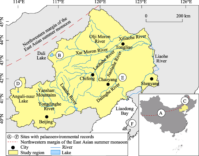
Figure 1 Location map of the Yan-Liao region with major river systems and cities. The white circles with the letters A - F indicate sites with palaeoenvironmental records discussed in the text: A - Dunde Ice Core, B - Dali Lake, C - Hulun Lake, D - Anguli-nuur Lake, E - Chahai Site, and F - South Liaoning (39°30′N, 122°E). |
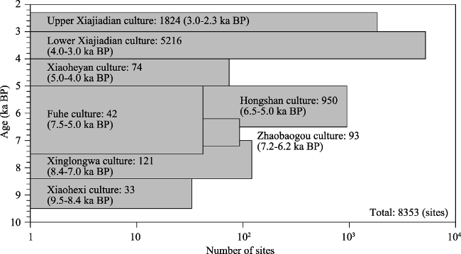
Figure 2 Quantitative changes in the number of archaeological sites of the studied prehistoric cultures with a chronological sequence |
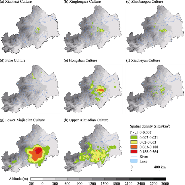
Figure 3 Spatial distributions of the archaeological sites of the studied prehistoric culture sequence. |
Table 1 Maximum density value of archaeological sites of each culture |
| Culture | Xiaohexi | Xinglongwa | Zhaobaogou | Fuhe |
|---|---|---|---|---|
| Maximum density (sites/km2) | 0.0359 | 0.0388 | 0.0367 | 0.0371 |
| Culture | Hongshan | Xiaoheyan | Lower Xiajiadian | Upper Xiajiadian |
| Maximum density (sites/km2) | 0.1515 | 0.0491 | 0.5630 | 0.0853 |
Figure 4 Spatial density map of archaeological sites of each culture |
Table 2 Results of nearest-neighbour analysis of archaeological sites of each culture |
| Culture | Xiaohexi | Xing- longwa | Zhaobaogou | Fuhe | Hongshan | Xiaoheyan | Lower Xiajiadian | Upper Xiajiadian |
|---|---|---|---|---|---|---|---|---|
| ANN | 0.966 | 0.616 | 0.596 | 0.735 | 0.405 | 0.725 | 0.159 | 0.474 |
| p-value | 0.710 | 0.000 | 0.000 | 0.001 | 0.000 | 0.000 | 0.000 | -0.000 |
| z-score | -0.372 | -8.079 | -7.463 | -3.279 | -35.069 | -4.518 | -116.207 | -42.993 |
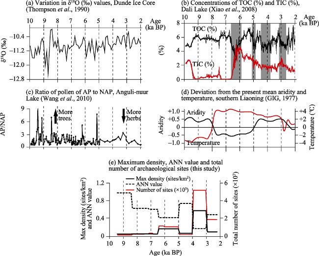
Figure 5 Comparisons of the palaeoenvironmental and archaeological records: (a) the variation in δ18O (‰) values from the Dunde Ice Core; (b) the concentrations of total organic carbon (TOC, %) and total inorganic carbon (TIC, %) of the sediment core from Dali Lake; (c) the ratio of pollen of arboreal plants (AP) to that of non-arboreal plants (NAP) in the Anguli-nuur Lake; (d) the reconstruction of deviation from the present mean aridity and temperature in South Liaoning; (e) the changes in the maximum density, ANN value and total number of archaeological sites |
The authors have declared that no competing interests exist.
| [1] |
ArcGIS, December 2016. What is a z-score? What is a p-value? Environmental Systems Research Institute (ESRI), California.
|
| [2] |
|
| [3] |
|
| [4] |
|
| [5] |
|
| [6] |
CHGIS, 2017. CHGIS Version 4. Cambridge: Harvard Yenching Institute and Fudan Center for Historical Geography. .
|
| [7] |
Chinese Academy of Sciences (CAS), 1984. Physical Geography of China: Climate. Beijing: Science Press, 158. (in Chinese)
|
| [8] |
Chifeng International Collaborative Archaeological Research Project (CICARP), 2003. Regional Archaeology in Eastern Inner Mongolia: A Methodological Exploration. Beijing: Science Press. (in Chinese)
|
| [9] |
|
| [10] |
|
| [11] |
|
| [12] |
|
| [13] |
|
| [14] |
|
| [15] |
|
| [16] |
|
| [17] |
|
| [18] |
|
| [19] |
|
| [20] |
|
| [21] |
|
| [22] |
|
| [23] |
Institute of Archaeology of Chinese Academy of Social Sciences (IACASS), 1996. Report of Archaeological Excavation of Settlement Sites and Tombs of Dadianzi Site of Lower Xiajiadian Culture. Beijing: Science Press. (in Chinese)
|
| [24] |
Institute of Archaeology of Chinese Academy of Social Sciences (IACASS), 1997. Zhaobaogou Site, the Neolithic Settlement Site in Aohan Banner. Beijing: Encyclopedia of China Publishing House. (in Chinese)
|
| [25] |
Institute of Archaeology of the Inner Mongolia Autonomous Region (IAIMAR), 2004. Report of Archaeological Excavation of the Neolithic Settlement, Baiyinchanghan Site. Beijing: Science Press. (in Chinese)
|
| [26] |
Institute of Archaeology of the Inner Mongolia Autonomous Region (IAIMAR) and Liaozhongjing Museum in Ningcheng County (LMNC), 2009. Report of Archaeological Excavation of Xiaoheishigou Settlement Site of Upper Xiajiadian Culture. Beijing: Science Press. (in Chinese)
|
| [27] |
Institute of Archaeology of Liaoning Province (IALP), 2012a. Report of Archaeological Excavation of the Neolithic Settlement, Chahai Site. Beijing: Cultural Relics Press. (in Chinese)
|
| [28] |
Institute of Archaeology of Liaoning Province (IALP), 2012b. Report of Archaeological Excavation of Niuheliang Settlement Site of Hongshan Culture, from 1983 to 2003. Beijing: Cultural Relics Press. (in Chinese)
|
| [29] |
|
| [30] |
|
| [31] |
|
| [32] |
|
| [33] |
|
| [34] |
|
| [35] |
|
| [36] |
|
| [37] |
|
| [38] |
|
| [39] |
State Administration of Cultural Heritage (SACH), 2003. Atlas of Chinese Cultural Relics: Inner Mongolia Autonomous Region Volume. Xi’an: Xi’an Cartographic Publishing House. (in Chinese)
|
| [40] |
State Administration of Cultural Heritage (SACH), 2008. Atlas of Chinese Cultural Relics: Beijing Volume. Beijing: Science Press. (in Chinese)
|
| [41] |
State Administration of Cultural Heritage (SACH), 2009. Atlas of Chinese Cultural Relics: Liaoning Volume. Xi’an: Xi’an Cartographic Publishing House. (in Chinese)
|
| [42] |
State Administration of Cultural Heritage (SACH), 2013. Atlas of Chinese Cultural Relics: Hebei Volume. Beijing: Cultural Relics Press. (in Chinese)
|
| [43] |
|
| [44] |
|
| [45] |
|
| [46] |
|
| [47] |
|
| [48] |
|
| [49] |
|
| [50] |
|
| [51] |
|
| [52] |
|
| [53] |
|
| [54] |
|
| [55] |
|
| [56] |
|
| [57] |
|
| [58] |
|
| [59] |
|
| [60] |
|
| [61] |
|
| [62] |
|
| [63] |
|
/
| 〈 |
|
〉 |
