Research Articles

Cosmogenic nuclide burial dating of Liuwan Paleolithic site in the Luonan Basin, Central China

  • WANG Kexin 1 ,
  • XU Xinghua 1 ,
  • SUN Xuefeng , 1, * ,
  • TU Hua 2 ,
  • ZENG Qiongxuan 1 ,
  • LU Yiming 1 ,
  • LU Huayu 1 ,
  • WANG Shejiang 3, 4
Expand
  • 1. School of Geography and Ocean Science, Nanjing University, Nanjing 210023, China
  • 2. BGEG, School of Earth Sciences, China University of Geosciences, Wuhan 430074, China
  • 3. Key Laboratory of Vertebrate Evolution and Human Origins of Chinese Academy of Sciences, Institute of Vertebrate Paleontology and Paleoanthropology, CAS, Beijing 100044, China
  • 4. CAS Center for Excellence in Life and Paleoenvironment, Beijing 100044, China
*Corresponding author: Sun Xuefeng, Associate Professor, E-mail:

Author: Wang Kexing, PhD, specialized in cosmogenic nuclide burial dating.

Received date: 2018-01-13

  Accepted date: 2018-05-30

  Online published: 2019-03-20

Supported by

National Natural Science Foundation of China, No.41572155, No.41690111

The Global Change Program of the Ministry of Science and Technology of China, No.2016YFA0600503

Copyright

Journal of Geographical Sciences, All Rights Reserved

Abstract

The Luonan Basin is a key region of early human settlement in Central China with more than 300 discovered Paleolithic sites. Artifact layer 1 of the Liuwan site was dated to approximately 0.6 million years (Ma) based on correlation with the well-dated loess-paleosol sequence of the central Chinese Loess Plateau. This study reassessed the age of the Liuwan artifact layer via an absolute dating method, namely, 26Al/10Be burial dating. We determined the burial age of artifact layer 1, which was most likely at least 0.60 ± 0.12 Ma (1ơ), using three simple burial ages. The new burial age confirmed the previous estimated age and provided a considerably accurate age range. Therefore, we suggest the use of the 26Al/10Be burial dating method in thin loess-covered Paleolithic sites around the Qinling Mountain Range is helpful to understand the early human behavior.

Cite this article

WANG Kexin , XU Xinghua , SUN Xuefeng , TU Hua , ZENG Qiongxuan , LU Yiming , LU Huayu , WANG Shejiang . Cosmogenic nuclide burial dating of Liuwan Paleolithic site in the Luonan Basin, Central China[J]. Journal of Geographical Sciences, 2019 , 29(3) : 406 -416 . DOI: 10.1007/s11442-019-1606-1

1 Introduction

China is a key area of early human settlement in East Asia during the Pleistocene. The Qinling Mountain Range (QMR) in Central China is a recognized center of early human occupation (Woo, 1964, 1966; Xue, 1987; Li and Etler, 1992; Wang et al., 1997, 2004, 2005, 2008; SPIA et al., 2007, 2008; Lu et al., 2007, 2011a, 2012, 2017; Wang and Lu, 2014, 2016; Sun et al., 2017), which can correspond to the well-known Nihewan Basin in North China (Chia and Wei, 1978; Zhu et al., 2001; Deng et al., 2006). The QMR is highlighted by hundreds of Paleolithic open-air sites and characteristic artifacts, such as hand axes, spheroids, picks, and heavy-duty scrapers (Wang et al., 2005; SPIA et al., 2007).
A few Paleolithic sites in the QMR, such as Liuwan (Lu et al., 2007, 2011b; Sun et al., 2014), Qijaojiayao (Lu et al., 2007, 2011a), Yaochangwan (Sun et al., 2012; Wang et al., 2014), and Luojiacun (Sun et al., 2017), have been dated approximately 0.60 Ma. The period of dense hominin settlement in the QMR was approximately 0.60 Ma. However, only several hominin fossil sites were found during this period (approximately 0.50-0.80 Ma) in China based on credible archaeological data. These archaeological sites were distributed between 20°N and 40°N latitude (Figure 1). Therefore, hominin settlement and distribution in the QMR during approximately 0.60 Ma are important for understanding early human evolution in China.
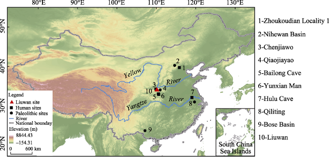
Figure 1 Locations of the Liuwan Paleolithic site in China and other Middle Pleistocene (approximately 0.50-0.80 Ma) hominin fossil and Paleolithic sites
An old and deeply rooted question is whether climate change shapes human evolution (Potts, 1998, 2012). Landforms and elevation are two important influential factors in human evolution. Hominin settlements were mainly located in riverine areas or fluvial terraces, particularly in medium-sized fluvial basins in China (Lu et al., 2017), such as the Nihewan Basin (Zhu et al., 2001, 2007) and the Bose Basin (Hou et al., 2000). Many Middle Pleistocene hominin fossil and Paleolithic sites, such as Zhoukoudian Locality 1 (Shen et al., 2009), Chenjiawo (An and Ho, 1989), and Yunxian Man (Li and Etler, 1992; Chen et al., 1997), are on the second step or the transition between the second and third steps in China (Lu et al., 2017) (Figure 1). Although Hulu Cave (Zhao et al., 2001; Liu et al., 2005) and Qiliting (Archaeology and Office, 2009) are in the Middle-Low Yangtze Plains, these areas are in hilly and mountainous locations near rivers (Figure 2).
Figure 2 Location of the Liuwan Paleolithic site in the Luonan Basin and other Paleolithic sites approximately 0.60 Ma in the Qinling Mountains Range
The QMR in Central China is a natural barrier that functions as a boundary between the southern and northern climatic regimes and is a sensitive area for climate change controlled by the Asian monsoon. The QMR is a representative zone for the middle latitude, intermountain basins, and warm areas. Thus, Paleolithic discoveries are found in the Luonan and Lushi Basins along the South Luohe River Valley in eastern QMR, in the Hanzhong, Ankang, Yunxian, and Danjiang basins along the Hanjiang River Valley in southern QMR, and in the Lantian Basin along the Bahe River Valley in northern QMR (Figure 2). All these Paleolithic sites are covered with thin loess deposits along medium-sized rivers.
We dated many Paleolithic sites (Lu et al., 2007, 2011a, 2011b; Sun et al., 2012, 2014, 2016, 2017) in the QMR using pedostratigraphic correlation with the well-dated loess-paleosol sequence of the Luochuan loess section of the central Chinese Loess Plateau (CLP). We identified a certain range of age error in these Paleolithic sites due to restrictions imposed by the paleomagnetic dating method and the problematic magnetic susceptibility used in thin and atypical loess deposition areas.
An absolute age control from a radioisotopic dating method is required to assess previously established chronologies of these Paleolithic sites. In the current study, we attempted to date the Liuwan Paleolithic site in the Lunan Basin by using the 26Al/10Be burial dating method. This method is a relatively new radioisotopic dating technique based on the built-up and radioactive decay of two cosmogenic nuclides.

2 Geographical, archaeological, and stratigraphic settings

2.1 Geographical setting

The Luonan Basin is an intermountain depression in the upper drainage of the South Luohe River (Figure 2). The terrace system of this river is composed of alluvial and thin loess deposits along the flanks of the river valleys. The Liuwan Paleolithic site (34°08′37″N, 110°08′13″E; 948 m above sea level) is located 6 km north of Luonan City. This site is situated on the second terrace of the Maping River, which is the main tributary of the South Luohe River (Figure 2). Low hills with an average elevation of 1000 m are found along both sides of the Maping River. This river is short, and the Liuwan site is only approximately 10 km from its headstream.

2.2 Archaeological setting

More than 20,000 lithic artifacts in over 300 Paleolithic sites have been discovered in the Luonan Basin from low to high terraces along the South Luohe River, thereby making the latter the richest Paleolithic artifact basin in Central China (Wang et al., 2005; SPIA et al., 2007).
The Luonan Basin was first determined to be attractive to the prehistoric community in the 1990s after a few Paleolithic artifacts were individually collected on the surface (by SJ Wang) from various landforms in this region. Thereafter, several sites with in situ artifacts, including Liuwan (locality 1), which is the most representative and contains distinct alternations of loess and paleosol, have been excavated and studied (Lu et al., 2007, 2011a, 2011b). In 2009, Sun et al. (2014) revisited the site and found two additional localities (localities 2 and 3) (Figure 3). Two in situ stone artifact layers were identified and more than 200 artifacts, including stone hammers, scrapers, points, cores, flakes, debris, and chunks, were unearthed during the trial excavation.
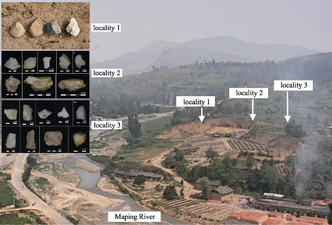
Figure 3 Positions and Paleolithic artifacts of localities 1, 2, and 3 in the Liuwan site. Collected hand axes in locality 1, excavated Paleolithic artifacts in artifact layer 1 in locality 2, and excavated Paleolithic artifacts in artifact layer 2 in locality 3 (Lu et al., 2007; Sun et al., 2014).
The loess deposit is approximately 500 cm thick in Liuwan locality 3, and three loess units interleaved with four paleosol complexes were identified (Figure 3). Artifact layer 1 lies approximately 160 cm below layer 2. This artifact layer is between 445 cm and 450 cm deep and contains 33 artifacts. Artifact layer 2 is situated at 305 cm and has a thickness of 5 cm. A total of 107 artifacts were excavated in this locality.

2.3 Stratigraphic setting

We studied the pedostratigraphy and magnetic susceptibility of Liuwan localities 2 and 3 (Sun et al., 2014) and compared their results with those of locality 1 and a typical loess-paleosol sequence in Luochuan (Lu et al., 2007). The result is still comparable although magnetic susceptibility, as a paleoclimate proxy in the Liuwan site, differs from the magnetic susceptibility recorded in the loess-paleosol sequence of the CLP (Lu et al., 2007; Sun et al., 2014). Nevertheless, we significantly correlated localities 1, 2, and 3 using the L5 layer as a prominent marker in the pedostratigraphy and magnetic susceptibility records (Sun et al., 2014). We found S5, L5, S4, S3, L3, S2, L2, S1, and L1 layers in locality 2. Only S5, L5, and the combined S4 and S3 layers were found in locality 3 for the upper part of the loess deposition transferred by local farmers for brick making. Although the loess deposit is thin, no evident hiatus was generally observed in the section. As shown in Figure 3, the loess-paleosol sequence in the Liuwan section is a condensed and “mini” type of the Luochuan loess-paleosol sequence.
Artifact layer 2 was suggested to be located in paleosol unit S5SS2, whereas artifact layer 1 is located in the S5SS3 soil unit based on the pedostratigraphy and magnetic susceptibility of localities 1, 2, and 3 (Sun et al., 2014). Therefore, the approximate ages of the two layers are 0.60 Ma (Lu et al., 1999).

3 Method and experiments

3.1 Sampling

We collected three sets of Paleolithic artifacts from artifact layer 1 at the bottom of the Liuwan site for 26Al/10Be burial dating. This area was the lower artifact layer. Each set of samples comprised four to five pieces of vein quartz chunks (Figure 4). These samples were collected in situ from the loess deposits.
Figure 4 Positions of 26Al and 10Be burial dating samples in artifact layer 1 (black triangles) in the Liuwan localities and magnetostratigraphy, pedostratigraphy, and magnetic susceptibility records correlated with the Luochuan loess-paleosol sequence in Central CLP (Lu et al., 2007; Sun et al., 2014)

3.2 26Al/10Be burial dating

The 26Al/10Be burial dating technique is an important method for dating quartzose deposits buried in the past 0.3-5.0 Ma and is particularly used in regions where K/Ar (Ar/Ar) is inapplicable. After its first application to cave deposits (Granger et al., 1997), the 26Al/10Be burial dating method has been successfully used in river fluvial deposits (Granger and Smith, 2000), lacustrine sediments (Kong et al., 2009), and conglomerate deposits (Kong et al., 2011; Tu et al., 2017).
The basic theory of 26Al/10Be burial dating has been elucidated by Granger and Muzikar (2001) and Granger (2014). The theory assumes that quartz mineral is gradually exposed in an outcrop that erodes steadily, and certain amounts of 26Al and 10Be will be produced by secondary cosmic rays. The ratio of the production rates of the two nuclides is basically constant and is typically assumed to be 6.8. If quartz is buried by meters of sediments or rushed into caves, then cosmogenic 26Al and 10Be production drastically decelerates. The inherited nuclides decay according to their specific half-lives, whereas a continued slow accumulation of nuclides through muon-induced reactions may persist. For samples that inherited a high concentration of nuclides and were buried deeply and rapidly, post-burial production is minimal and can be safely disregarded. In this case, the calculated age is referred to as the simple burial age. However, the reliability of simple burial dating will be affected in two cases. In the first case, the sample was not buried rapidly and deeply enough to be shielded quantitatively against cosmic rays; thus, the obtained age result will be underestimated. In the second case, the sample experienced prior burial before the last deposition; thus, the age result will be overestimated.
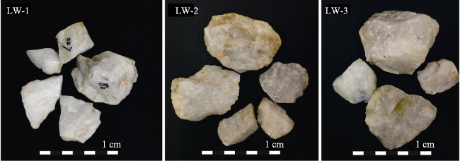
Figure 5 Dating samples from artifact layer 1 in Liuwan locality 3 (each group is a mixture of several vein quartz chunks)

3.3 Sample preparation and measurements

The samples were pretreated in Nanjing University and Nanjing Normal University in China. Raw samples were crushed into submillimeter grains, and samples between 0.2 mm and 0.5 mm were sieved out and purified through hydrofluoric acid (HF) leaching and magnetic and gravimetric separations. Then, the samples were analyzed in the Australian Nuclear Science and Technology Organization (ANSTO). The purified quartz (50-100 g) was dissolved in HF/HNO3 and spiked with approximately 0.3 mg 9Be carrier. After HF volatilization, Fe was removed by pH-controlled precipitation. Al and Be were separated by ion exchange chromatography, and Be was further purified using precipitation and chromatography. Al and Be were then precipitated as hydroxides and transformed into oxides in a furnace at 800°C. Al2O3 and BeO were loaded into cathodes for 10Be/9Be and 26Al/27Al measurements using an accelerator mass spectrometer at the ANTARES Accelerator Mass Spectrometry (AMS) Facility, ANSTO.

4 Result

The AMS measurement of the three samples from the Liuwan site resulted in relatively good precision, namely, 2%-4% for 26Al/27Al and approximately 2% for 10Be/9Be. The integrated precision percentages in nuclide concentration were 5%-6% and approximately 3% for 26Al and 10Be, respectively. Table 1 lists the nuclide concentrations and the corresponding simple burial ages. The simple burial ages (i.e., LW-1: 0.14 ± 0.11 Ma; LW-2: 0.20 ± 0.13 Ma; and LW-3: 0.60 ± 0.12 Ma) were calculated by assuming that the samples did not experience prior burial and did not undergo post-burial production.
Table 1 Cosmogenic nuclide concentrations and simple burial ages of the vein quartz chunks from artifact layer 1 in Liuwan locality 3
Sample Description Burial depth (m) 10Be concentration
(×106 at g-1)
26Al concentration
(×106 at g-1)
26Al/10Be Minimum age (Ma) Burial age
(Ma)
LW-1 Paleolithic artifacts 4.5 0.2314 ± 0.0062 1.4401 ± 0.0719 6.223 ± 0.352 0.144 ± 0.115 0.144 ± 0.115
LW-2 Paleolithic artifacts 4.5 0.1895 ± 0.0062 1.1502 ± 0.0686 6.068 ± 0.412 0.201 ± 0.137 0.201 ± 0.137
LW-3 Paleolithic artifacts 4.5 0.4182 ± 0.0113 2.0541 ± 0.1106 4.912 ± 0.296 0.599 ± 0.122 0.599 ± 0.122

Minimum ages are obtained by assuming that the samples are completely shielded from cosmic rays after burial, without considering the nuclides produced during and after the depositional process caused by insufficient shielding against cosmic rays.

The accuracy of the simple burial ages highly depends on the validation of the two assumptions. First, we considered that the Liuwan samples were unlikely to have prior burial history because the Liuwan site is situated on the second terrace of the Maping River, which is approximately 10 km to the headstream of the river. The artifacts, including our dating samples, were most likely made of raw materials collected from the river bed at the time of human occupation. No depositional basin is present upstream; hence, the possibility that our samples might have been buried previously elsewhere is unlikely. Accordingly, the overestimation of the simple burial ages is improbable.
Second, the dating samples were buried in approximately 4.5 m-thick loess-paleosol. The overburden was insufficiently thick to shield quantitatively against cosmic rays, and the sedimentation rate of these aeolian deposits was relatively slow. Thus, the nuclides produced during and after the sedimentation process could not be completely disregarded. Moreover, the simple burial ages of the samples should have been underestimated. Although the three samples are supposed to be of the same true age and have identical post-burial components, their apparent ages vary significantly. One reason is that the underestimation degree of different samples depends on their inherited nuclide concentrations, i.e., samples with high concentrations yielded old apparent simple burial ages. The Liuwan samples followed this tendency within the error range.
The three simple burial ages are most likely minimal estimates; therefore, we suggest to use the oldest one (LW-3: 0.60 ± 0.12 Ma) to mark the minimal age of cultural layer 1 in the Liuwan site.

5 Discussion

5.1 Dating problems in the QMR

With loess-paleosol alternations contained loess. Loess is considered a significant archive of past environmental changes and provides a precise time series for studying hominin evolution. However, issues remain despite our successful application of optically stimulated luminescence (OSL) dating, thermally transferred OSL (TT-OSL) dating of quartz, post-infrared infrared stimulated luminescence (post-IRIRSL) dating of K-feldspars, magnetostratigraphic analyses, and pedostratigraphic correlation with the well-dated loess-paleosol sequence of the CLP to set a basic time series for several sites (Sun et al., 2012, 2013, 2016, 2017).
The loess deposited in the southern and eastern Qinling Mountain areas differs from the typical loess deposited in the CLP. Accordingly, the thin loess deposit in a few high terraces is merely a short segment that contains the old part of the entire loess-paleosol sequence, whereas the young part on the surface has been eroded (Guo et al., 2013; Sun et al., 2017). This scenario presents a major obstacle to directly comparing the incomplete loess-paleosol sequence with the typical sequence of the CLP for the missing upper loess-paleosol sequence. In a few sites that are younger than 0.2 Ma, the use of the reference OSL, TT-OSL, and post-IRIRSL ages and magnetic susceptibility will enable the correlation of the incomplete loess-paleosol sequence with the complete loess-paleosol sequence in the CLP (Sun et al., 2017).
However, the surface part of the loess section has already exceeded the dating ranges of OSL, TT-OSL, and post-IRIRSL, and no paleomagnetic alternation occurred for the span between approximately 0.20 Ma and 0.78 Ma or older than 0.78 Ma. These conditions are considerably common in the Middle to Early Pleistocene Paleolithic sites in the southern and eastern Qinling Mountains, particularly on high terraces. Moreover, suitable materials for the K/Ar dating and 230Th/234U dating in the loess-deposited areas are rarely available. Although we determined a few loess-paleosol segments, no reference age was obtained. The correlation of the incomplete loess-paleosol sequence with the complete loess-paleosol sequence in the CLP is questionable without any radiometric age control.

5.2 Use of burial dating method

In this study, the simple burial ages of loess-covered artifacts provided a minimal age control (0.60 ± 0.12 Ma) for Liuwan locality 3, thereby allowing the correlation of the incomplete loess-paleosol sequence of the site with the complete loess-paleosol sequence in the CLP and supporting the previous age estimate from Sun et al. (2014). Combined with the normal polarity of the entire strata (Figure 3), which should correspond to the Brunhes Chron (<0.78 Ma), artifact layer 1 in the Liuwan Paleolithic site most likely dates back to 0.60-0.78 Ma. This result reconfirmed that hominins occupied the Luonan Basin since at least 0.60 Ma.
Restricted by the unignorable post-burial produced cosmogenic nuclides, a simple burial dating method cannot yield an accurate age for loess-covered samples. Nonetheless, the method can provide a minimal age control to the site, which is valuable in correlating the incomplete paleomagnetic and pedostratigraphic records with the reference ones.
A simple burial dating method is still recommended only to date samples that were rapidly and deeply buried or loess-covered samples with relatively high inherited nuclides and thick burial depth. For loess-covered samples, an alternative and more reliable approach for dating is the isochron burial dating method (Erlanger et al., 2012). This approach provides a means to determine the true burial age of shallowly buried samples and is proven useful in dating loess-covered samples by analyzing a set of clasts (or stone artifacts) from the same horizon level (Tu et al., 2017).
Many Early-Middle Pleistocene Paleolithic sites in China were recovered from aeolian deposits, such as Xiashu loess, reticulate red clay, and Quaternary red clay. Most of these sites, including the Chenshan Paleolithic sites in Xuancheng, Anhui Province (Yang et al., 1997; Fang et al., 1997), the Qiliting Paleolithic sites in Changin, Zhejiang Province (Xu 2008; Liu et al., 2014), and the Huxushan Paleolithic site in Chishandao, Hunan Province, were dated using the paleomagnetic dating method or stratigraphic correlation. Only a few of these sites have been accurately dated. Therefore, we hope that the application of cosmogenic burial dating can contribute to the chronological framework of Early-Middle Pleistocene human evolution in East Asia.

6 Conclusions

Three groups of vein quartz artifacts in artifact layer 1 in Liuwan locality 3 were dated in situ using the simple 26Al and 10Be burial dating method. The simple burial dating ages were 0.14 ± 0.11, 0.20 ± 0.13, and 0.60 ± 0.12 Ma. The post-burial production of these samples was not negligible, and the simple burial ages should be considered as minima given the relatively slow sedimentation rate and thin burial depth. Therefore, artifact layer 1 in locality 3 should be older than 0.60 ± 0.12 Ma. The magnetostratigraphical record also indicates that the site is most likely dated to 0.60-0.78 Ma. Therefore, the application of the minimum age of the simple 26Al and 10Be burial dating method is useful in dating Paleolithic artifacts in thin loess-covered Paleolithic sites in the QMR and in Southern China.

Acknowledgment

We thank Prof. David Fink for his help in the laboratory work, and Prof. Guanjun Shen for his help and encouragement.

The authors have declared that no competing interests exist.

[1]
An Z H, Ho C K, 1989. New magnetostratigraphic dates of Lantian Homo-Erectus.Quaternary Research, 32: 213-221.https://www.cambridge.org/core/product/identifier/S003358940002007X/type/journal_articleSkeletal remains of Homo erectus found in Pleistocene loess at two sites near Lantian in central China are of greatly different geologic age. The cranium found in the fossil-bearing strata at Gongwangling is about 1.15 myr old whereas the remains found at the Chenjiawo locality in middle Pleistocene loess are about 0.65 myr old. The dating is based on new paleomagnetic polarity determinations and on the lithostratigraphic position of the fossils in the loess-paleosol sequence. Our results confirm that both localities are older than the first occupation of Zhoukoudian. New dates, palaeoenvironmental settings, and morphological features of the hominids from Lantian localities have significant bearing on the understanding of adaptive radiations of the middle and late hominids in Asia.

DOI

[2]
Chen T M, Yang Q, Hu Y Qet al., 1997. ESR dating of tooth enamel from Yunxian Homo erectus site, China. Quaternary Science Reviews, 16: 455-458.http://linkinghub.elsevier.com/retrieve/pii/S0277379196000959Two almost complete fossil hominid crania (EV9001 and EV9002) were found in 1989 and 1990 in Middle Pleistocene terrace deposit of Han River, Yunxian county, Hubei province, China. They are classified as Homo erectus . Nine fossil animal teeth stratigraphically associated with the skulls were selected for electron spin resonance (ESR) dating. The simple exponential function was used for determination of the accumulated dose De and its appropriateness was discussed on the base of the experimental study. The closed system assumption was checked and the early uranium uptake model was applied to age determination. A mean age value was yielded to be 581 93 ka. It deviates from the palaeomagnetic dating result of 830-870 ka. Micro-regional complete saturation of ESR signal in enamel of very high U-content may account for the underestimation of ESR ages. Nevertheless both ESR and palaeomagnetic dating results place Yunxian crania in between the Homo erectus of Lantian and Zhoukoudian, which means that Yunxian crania constitute an important link in the human evolutionary lineage of China.

DOI

[3]
Chia L P, Wei C, 1978. A Palaeolithic site at Hsu-Chia-Yao in Yanggao County, Shanxi Province.Acta Archaeologia Sinica, 2: 97-114. (in Chinese)

[4]
Deng C L, Wei Q, Zhu R X et al., 2006. Magnetostratigraphic age of the Xiantai Paleolithic site in the Nihewan Basin and implications for early human colonization of Northeast Asia.Earth and Planetary Science Letters, 244: 336-348.https://linkinghub.elsevier.com/retrieve/pii/S0012821X06001245Timing of the early habitation and stone technologies in the Nihewan Basin, North China has provided insights into our understanding of early human adaptability to high northern latitudes in East Asia. Here we contribute to this topic with detailed magnetostratigraphic investigation, coupled with mineral magnetic measurements and palynological analyses on a lacustrine sequence in this basin, which contains the Xiantai Paleolithic site. Magnetite and hematite were identified as the main carriers for the characteristic remanent magnetizations. Magnetostratigraphic results show that the Xiantai lacustrine sequence recorded the Brunhes chron, the Jaramillo and the Olduvai subchrons, and successive reverse polarity portions of the intervening Matuyama chron. Stratigraphic correlation in terms of lithology, magnetic susceptibility and magnetic polarity sequences between the Xiantai and Xiaochangliang sections indicates that the Xiantai artefact layer is readily contemporary with the Xiaochangliang artefact layer, which has been previously estimated to be about 1.36 Ma [R.X. Zhu, K.A. Hoffman, R. Potts, C.L. Deng, Y.X. Pan, B. Guo, C.D. Shi, Z.T. Guo, B.Y. Yuan, Y.M. Hou, W.W. Huang, Earliest presence of humans in northeast Asia, Nature 413 (2001) 413鈥417.]. Early humans of the Xiantai Paleolithic site lived in a steppe paleoenvironment indicated from fossil pollens. Furthermore, the combined evidence of our magnetostratigraphy and previously published magnetochronology and paleoclimate data documents that early humans of North China were able to adjust to an increasing variability of paleoclimates and paleoenvironments over the Early Pleistocene.

DOI

[5]
Erlanger E D, Granger D E, Gibbon R J, 2012. Rock uplift rates in South Africa from isochron burial dating of fluvial and marine terraces.Geology, 40: 1019-1022.http://pubs.geoscienceworld.org/geology/article/40/11/1019/130729/Rock-uplift-rates-in-South-Africa-from-isochronABSTRACT The high plateau of southern Africa is considered to be either uplifting due to mantle-driven dynamic topography, or to have been stable since Mesozoic rifting. To address this debate, we determined rock uplift in South Africa from the long-term incision rate of the Sundays River, near Port Elizabeth, and from an uplifted marine terrace near Durban. We dated the terraces with cosmogenic Al-26 and Be-10, using both isochron and simple burial dating methods. We find that the Sundays River has incised at 16.1 +/- 1.3 m/m.y. for the past similar to 4 m.y., and the marine terrace yields a rock uplift rate of 9.4 +/- 2.2 m/m.y. These results are inconsistent with rapid Neogene uplift.

DOI

[6]
Fang Y S, 1997. A Report on Excavation of Chenshan Locality in 1988, Anhui Province.Acta Anthropologica Sinica, 16(2): 96-106. (in Chinese)http://en.cnki.com.cn/Article_en/CJFDTotal-RLXB702.001.htmThe Chenshan (Xiangyang) Paleolithic locality (118°51′58″ E, 30°52′32″ N) is situated at middle reach of Shuiyang River about 15 kilometres to the southwest of Xuanzhou City. The locality was discovered in 1987. In the first excavation in March May,1988,78 stone artifacts were found by the present authors and other colleagues. The raw material of the artifacts is mainly quartzite sandstone. Stone artifacts include flakes, cores, scrapers, choppers, pointed choppers and picks. The proportions of them are 29 5%, 29 5%, 9 0%, 14 1%, 3 8% and 5 1% respectively. The strata of the Chenshan locality are divided two parts: the lower part is from the late period of the early Pleistocene to the middle period of the middle Pleistocene and the upper part is of the late period of the middle Pleistocene

[7]
Granger D E, 2014. Cosmogenic nuclide burial dating in archaeology and paleo- anthropology. In: Holland H D, Turekian K K (eds.). Treatise on Geochemistry. 2nd ed. Oxford: Elsevier, 81-97.Cosmogenic 26 Al and 10 Be in quartz can be used to date when mineral grains were buried, over a timescale ranging up to 5 Ma. 26 Al and 10 Be accumulate over time in quartz that is exposed near the ground surface. If this quartz is buried, for example, in a cave or in a river terrace deposit, then the inherited 26 Al and 10 Be decay over time, providing a clock that dates sediment burial. The burial dating method is widely applicable to quartz contained either in sediment or stone tools, and is increasingly being applied in archaeology. This chapter explains the theory of burial dating, with examples from archaeology and paleoanthropology. Applications include simple burial dating, applied to very deeply buried deposits such as cave sediments; complex burial dating, which can apply minimum and maximum constraints to a burial age; and isochron burial dating, which can be applied to sediment buried beneath only a few meters of overburden.

DOI

[8]
Granger D E, Kirchner J W, Finkel R C, 1997. Quaternary downcutting rate of the New River, Virginia, measured from differential decay of cosmogenic 26Al and 10Be in cave-deposited alluvium.Geology, 25(2): 107-110.https://pubs.geoscienceworld.org/geology/article/25/2/107-110/206540

DOI

[9]
Granger D E, Muzikar P F, 2001. Dating sediment burial with in situ-produced cosmogenic nuclides: Theory, techniques, and limitations. Earth and Planetary Science Letters, 188(1): 269-281.http://linkinghub.elsevier.com/retrieve/pii/S0012821X01003090Dating sediment burial over million-year time scales is crucial in many areas of the Earth sciences and archeology, but is often difficult using traditional techniques. Sediment burial can be dated by the radioactive decay of cosmogenic nuclides, provided that the sediment was exposed to cosmic rays prior to burial. Dating calculations are straightforward if sediment is buried deeply and rapidly enough to prevent cosmogenic nuclide production after burial. However, the analysis can be complicated by postburial production if sediment is insufficiently shielded from secondary cosmic-ray nucleons and muons. This paper discusses how buried sediments can be dated over timescales up to 5 Myr using 26Al and 10Be in quartz.

DOI

[10]
Granger D E, Smith L A, 2000. Dating buried sediments using radioactive decay and muogenic production of 26Al and 10Be.Nuclear Instruments and Methods in Physics Research Section B: Beam Interactions with Materials and Atoms, 172(1): 822-826.http://www.sciencedirect.com/science/article/pii/S0168583X00000872Cosmogenic [ 26Al] and [ 10Be] depth profiles can be used to date river terrace sediments over million-year timescales, provided that production rates are well constrained with depth. Production by nucleon spallation, negative muon capture, and fast muon reactions can be approximated as exponential functions of depth, up to 655000 g cm 612. These production rates are used to date a 6510 m profile of eroded terrace sediments to 1.50 +0.32/ 610.25 Ma. The measured [ 10Be] profile and the terrace age agree well with expectations, demonstrating feasibility of the technique.

DOI

[11]
Guo Y Q, Huang C C, Pang J L et al., 2013. Sedimentological study of the stratigraphy at the site of Homo erectus yunxianensis in the upper Hanjiang River valley, China.Quaternary International, 300: 75-82.https://linkinghub.elsevier.com/retrieve/pii/S1040618212034118Geomorphological and sedimentological investigations were carried out in the upper Hanjiang River valley. The sediments in the profile at the site of Homo erectus yunxianensis were sampled systematically. Magnetic susceptibility, loss-on-ignition, particle size distribution and geochemical elements were analyzed in the laboratory. The results show that the medium sand and gravel beds in the lower part of the profile are fluvial deposits of the third terrace land of the Hanjiang River, the upper part is a blanket of aeolian loess and palaeosol deposited from dust storms and dust falls. According to stratigraphical correlation and palaeomagnetic dating, the carbonate nodules encasing the fossils of H. erectus yunxianensis and other mammalian faunas were formed during 800 785 ka. The palaeosol overlying on the fossil layer is defined as the S8 that was developed during the MIS-19, and the aeolian loess below the fossil layer is defined as L9 that was deposited during MIS-20. These loess and palaeosol are similar to those over the Chinese Loess Plateau and correlatable with those in the Luochuan loess profile. They are very different from the fluvial deposits in the Hanjiang River valley. These indicate that H. erectus yunxianensis lived at a climatic transition from glacial to interglacial. These results are very important in understanding the environment of H. erectus yunxianensis in the upper Hanjiang River valley.

DOI

[12]
Hou Y M, Potts R, Yuan B Y et al., 2000. Mid-Pleistocene Acheulean-like stone technology of the Bose basin, South China.Science, 287: 1622-1626.http://www.sciencemag.org/cgi/doi/10.1126/science.287.5458.1622Stone artifacts from the Bose basin, South China, are associated with tektites dated to 803,000 3000 years ago and represent the oldest known large cutting tools (LCTs) in East Asia. Bose toolmaking is compatible with Mode 2 (Acheulean) technologies in Africa in its targeted manufacture and biased spatial distribution of LCTs, large-scale flaking, and high flake scar counts. Acheulean-like tools in the mid-Pleistocene of South China imply that Mode 2 technical advances were manifested in East Asia contemporaneously with handaxe technology in Africa and western Eurasia. Bose lithic technology is associated with a tektite airfall and forest burning.

DOI PMID

[13]
Kong P, Granger D E, Wu F Y et al., 2009. Cosmogenic nuclide burial ages and provenance of the Xigeda paleo-lake: Implications for evolution of the Middle Yangtze River.Earth and Planetary Science Letters, 278(1/2): 131-141.https://linkinghub.elsevier.com/retrieve/pii/S0012821X08007504Hundred-meter-thick lacustrine sediments are widespread along the Middle Yangtze River. The distribution of these sediments suggests that an event blocked the river, forming a lake stretching 16002km from east to west and 11002km north to south, with a depth of ≥ 50002m. Using the cosmogenic nuclides 10Be and 26Al we have dated the time of burial of the lacustrine sediments and fluvial gravels beneath the sediments. Our results indicate a deposition age for these sediments between 1.34 and 1.5802Ma. Studies of zircon U–Pb age distributions within lacustrine sediments and fluvial sands related to the paleo-lake formation show diverse provenances from the upper Yangtze River and Yalong River, a major tributary of the Yangtze River. These deposits contain geologic fingerprints that allow identification of the source region of the lacustrine deposits and fluvial sands. Our results support the reversal of the Middle Yangtze River before the paleo-lake formation. We hypothesize that the geologic event that dammed the originally southward flow was the lateral movement of Chenghai fault in the Dali fault system initiated in early Quaternary. Water eventually cut through the spillway and flowed to the east.

DOI

[14]
Kong P, Zheng Y, Fu B H, 2011. Cosmogenic nuclide burial ages and provenance of Late Cenozoic deposits in the Sichuan Basin: Implications for Early Quaternary glaciations in east Tibet.Quaternary Geochronology, 6(3/4): 304-312.https://linkinghub.elsevier.com/retrieve/pii/S187110141100015XCollision between the Indian and the Eurasian plates since the early Cenozoic produces one of the world’s most remarkable continental escarpments between the Tibetan Plateau and the adjacent Sichuan Basin. Yet Tertiary sediments are rare in the Sichuan Basin; the oldest preserved Late Cenozoic deposits called Dayi conglomerates directly overlie the Cretaceous or Jurassic red beds. Using cosmogenic 10Be and 26Al burial dating, we obtain deposition ages of 652.002Ma and catchment erosion rates of 6540002mm/ka for the02Dayi conglomerates. Zircon U–Pb age distributions suggest derivation of these conglomerates from the Songpan-Ganzi flysch, the Pengguan complex and Late Permian and Triassic granite plutons in the headwater regions of the Min Jiang (Jiang, a Chinese term, means river). The formation of the poorly-sorted, sub-angular to sub-rounded and tens-centimeter-sized deposits in the western margin of the Sichuan Basin, after long distance transportation, is best explained by glacial activity 652.002Ma ago in east Tibet.

DOI

[15]
Li T, Etler D A, 1992. New Middle Pleistocene hominid crania from Yunxian in China.Nature, 357: 404-407

DOI

[16]
Liu C C, Deng C L, 2014. The effect of weathering on the grain-size distribution of red soils in south-eastern China and its climatic implications.Journal of Asian Earth Sciences, 94: 94-104.https://linkinghub.elsevier.com/retrieve/pii/S1367912014003770Particle-size analysis is a useful way to determine the source and deposition of sediments. However, there are inconsistencies when this method is used to constrain the origin of the red soils in south-eastern China. To address this problem, we performed a detailed grain-size analysis of two red soil sequences in Xuancheng and Qiliting located along the lower reaches of the Yangtze River. By comparing their particle-size characteristics with those of the loess on the Loess Plateau in northern China, we found that the aeolian samples plot in a particular zone in the C–M (grain size of the cumulative 1% versus median grain size) plot and cluster nearer the lower left corner of the plot as their degree of weathering increases. The grain-size features suggest that the onset of large-scale aeolian deposition along the lower reaches of the Yangtze River occurred at approximately 0.8Ma. Although both sedimentary sorting and post-depositional weathering control the grain-size variations in the deposits, the extremely strong weathering due to the humid, warm climate along the lower reaches of the Yangtze River primarily modified the grain-size distributions of the primary red soil deposits. Strong weathering increased the very fine silt (2–5μm) fraction and decreased the coarse (>63μm) fraction. We also found that certain grain-size parameters of the red soils varied with the weathering intensity, which can be used as indicators of palaeoclimate variations. The grain size variations in both the Qiliting and Xuancheng sequences suggest that the mid-Pleistocene climate transition (MPT) may have affected the lower reaches of the Yangtze River at 0.9Ma.

DOI

[17]
Liu W, Zhang Y, Wu X, 2005. Middle Pleistocene human cranium from Tangshan (Nanjing), Southeast China: A new reconstruction and comparisons with Homo erectus from Eurasia and Africa.American Journal of Physical Anthropology, 127: 253-262.http://doi.wiley.com/10.1002/%28ISSN%291096-8644The morphology and affinities of early and middle Pleistocene Homo erectus in East Asia have been explored since the late nineteenth century. A fragmentary hominid cranium (Nanjing no.1) recovered in Tangshan near Nanjing, China bears directly on these issues. In the present study, the morphological features of Nanjing no.1 are described and compared with Homo erectus from both Eurasia and Africa. Our results indicate that this middle Pleistocene hominid fossil should be referred to as Homo erectus. The sharing of typical Homo erectus features with African and European counterparts demonstrates that Homo erectus is a widely distributed lineage that evolved during the million years after its Pliocene origins. The differences between Nanjing no.1 and Zhoukoudian suggest certain level of regional variation in East Asian Homo erectus. Am J Phys Anthropol, 2005. ? 2004 Wiley-Liss, Inc.

DOI PMID

[18]
Lu H Y, Liu X D, Zhang F Q et al. , 1999. Astronomical calibration of loess-paleosol deposits at Luochuan, central Chinese Loess Plateau.Palaeogeography, Palaeoclimatology, Palaeoecology, 154: 237-246.http://linkinghub.elsevier.com/retrieve/pii/S0031018299001133The 140 m loess–paleosol profile at Luochuan in the central Chinese Loess Plateau was sampled at 5-cm intervals in loess units and at 3 cm in paleosol units, in order to obtain a high resolution climatic record covering the past 2.5 million years. All samples were measured for magnetic susceptibility, which is regarded as a good proxy index of the East Asian summer monsoon strength. On the basis of the astronomical theory of Pleistocene climatic change, an age model of the Luochuan loess–paleosol sequence was developed by tuning the magnetic susceptibility record to time-series of insolation changes. The results show that the ages of the boundaries between the Malan and Lishi, and Lishi and Wucheng loess formations are 71 and 1320 kyr BP, respectively. The onset of loess accumulation is at 2470 kyr BP. Our age model was tested by comparing the orbitally derived ages with absolute age determinations of magnetic reversals, and cross-spectrum analyzing with solar radiation variations for summer at 65°N. These indicate that the calibration provides a reliable time scale for the Luochuan loess–paleosol deposit.

DOI

[19]
Lu H Y, Sun X F, Wang S J et al. , 2011a. Ages for hominin occupation in Lushi Basin, middle of South Luo River, Central China.Journal of Human Evolution, 60(5): 612-617.https://linkinghub.elsevier.com/retrieve/pii/S004724841100008XA newly discovered Paleolithic site in loess deposits in the Lushi Basin, South Luo River, central China, is dated using pedostratigraphic analysis, optically stimulated luminescence (OSL) and magnetostratigraphic analysis. This region is regarded as an important place for hominin occupation and settlement during the early to middle Pleistocene. Results indicate that the archaeological site dates from 600 ka to 620 ka, reinforcing the view that Homo erectus had occupied a large area of eastern Asia by 620 ka. The lithic assemblages of Lushi Basin is a flake and core technology, typical for this time period in north-central China. It may be compared with that at the Zhoukoudian locality 1 in north China and some sites in the Luonan Basin, and provides important data for understanding the behavior and stone tool technology of early Chinese hominins.

DOI PMID

[20]
Lu H Y, Zhang H Y, Sun X Fet al., 2012. Landform, loess deposit and paleoenrivonmental changes in the South Luohe River (Central China) during the Hominin occupations.Quaternary Science, 32: 167-177. (in Chinese)http://www.en.cnki.com.cn/Article_en/CJFDTOTAL-DSJJ201202002.htmOver the past 20 years,more than 300 Paleolithic sites have been found in catchment of South Luohe River, Central China.This river is located at the environmental boundary between North and South China.To its south, climate is characterized by the subtropical monsoon;to the north,it is a warm temperate climate.Many lithic artifacts are scattered on the surface of various landforms and buried in aeolian loess deposits and cave sediments.The Paleolithic artifacts are made up of chopper-chopping(Mode 1) assemblages such as cores,flakes,choppers,scrapers and points and Acheulian-like large-cutting tools(Mode 2) such as hand-axes,cleavers,trihedrals,knives.The region contains both small tools reminiscent of North China and biface technology produced on large pebbles characteristic of South China.It appears that early humans repeatedly occupied this region. In summer of 2004,our interdisciplinary team was set up and field exploration focussed on different landforms, particularly loess deposits that reflected past environmental changes,was undertaken.Eight archaeological sites were excavated,and sediment samples were taken from 14 loess-paleosol sections.Over 20000 lithic artefacts were collected and more than 10 thousand loess samples have been obtained and studied. In this paper,we discuss recent findings during 2009 -2011 on understanding landform evolution,the loess- paleosol record,paleoenvironmental reconstruction and relationship between hominines behavior and these landforms. The results show that the landforms of the South Luohe River can be divided into two parts:the upper part is characterized by mountains and intermountain basins,with gorges and narrow rivers,where the channel gradient ratio is greater and the river current is relatively swift.The lower part is characterised by a piedmont plain with a smaller stream channel gradient ratio,where the river is braided with relatively slow flowing water.There is an extensive loess cover in this catchment,and its features are controlled by landform and local wind.The loess thickness is 2 ~25m in the upper part,to 30 ~90m in the middle and lower parts,with clear loess-paleosol alternations. The loess deposits are dated from the ca.llOOka to 30ka.We have used the loess chronology to age the stone artifacts buried in their layers.The results show that hominines have occupied this catchment for at least 800ka to 30ka,with several episodes of relative intensive human activity.Preliminary investigations on past environmental changes and hominine responses to them show that:1) landforms along the South Luohe River were relatively stable during Pleistocene,because the mountains and intermountain basins were formed before the hominines occupied this region.Stone tools are found both in situ and scattered across these landforms surfaces reaching altitudes of 600m. 2) a very preliminary spore-pollen analyses show that tree pollen was 25.3%~28.2%and grass pollen was 64.5%~ 71.4%during the glacial periods;it changed to 47.0%~ 54.7%and 34.9%~ 40.3%respectively during the interglacial period,with Pinus and Ulmaceae dominated the forest.The vegetation probably provided a wealth of food resources for early humans who adapted to the paleoclimate changes during these time periods. Our preliminary investigation shows that the South Luohe River is an important region for investigating early human behaviors and changing environments during Pleistocene.More detailed research works are needed to advance our understanding of the interplay between climate,human adaptation and technology during the Middle Paleolithic period of China.

DOI

[21]
Lu H Y, Zhang H Y, Wang S J et al. , 2007. A preliminary survey on loess deposit in Eastern Qinling Mountains (Central China) and its implication for estimating age of the Pleistocene lithic artifacts.Quaternary Sciences, 27(4): 559-567. (in Chinese)

[22]
Lu H Y, Zhang H Y, Wang S J et al. , 2011b. Multiphase timing of hominin occupations and the paleoenvironment in Luonan Basin, Central China.Quaternary Research, 76(1): 142-147.https://www.cambridge.org/core/product/identifier/S0033589400007717/type/journal_articleThousands of Paleolithic artifacts have been recovered from Paleolithic sites in the Luonan Basin, in the upper South Luohe River of central China. Their discovery suggests that the basin was an important area for hominin settlement during the Pleistocene. However, the initial timing of this occupation and the environmental conditions for this period are still largely unknown. In addition, the sediments are not well dated and most of the artifacts lie on the surface. In an attempt to resolve these issues, a new systemic paleomagnetic analysis was carried out on the loess deposits that contain in situ stone tools. Our detailed loess090009paleosol analyses of the stratigraphy of different sites in the basin and Chinese Loess Plateau shows the accumulation of the loess since at least 1.1 million years (Ma) ago. Moreover, recently discovered in situ cores, flakes and retouched stone tools in these deposits show that hominins used this region repeatedly from 0.80900090.7 Ma to 0.40900090.3 and 0.20900090.1 Ma. Pedostratigraphic analyses, magnetic susceptibility and carbon isotope analyses also indicate that these hominins lived in a subtropical to warm-temperate climate with broad-needle-leaf forest vegetation mixed with grasses.

DOI

[23]
Lu H Y, Zhuo H X, Zhang W C et al. , 2017. Earth surface processes and their effects on human behavior in monsoonal China during the Pleistocene-Holocene epochs.Journal of Geographical Sciences, 27(11): 1311-1324.http://link.springer.com/10.1007/s11442-017-1437-xThere is a wide diversity of landforms in China. The topography of three major terraces, decreasing in height stepwise from west to east, was formed by the early Miocene. With the commencement of the Great Northern Hemisphere Glaciations (GHGs) and the glacial-interglacial cycles in the Pleistocene, thick loess deposits accumulated in north China, and fluvial terraces were formed and lakes expanded and contracted in eastern and central China. The earliest evidence of hominins in China is dated to 1.7 Ma; they occupied the monsoon-dominated region for a long interval, until the late Pleistocene, 50 ka. In this study, we investigated a large area rich in the relics and artifacts of early man. The results indicate that the early humans occupied riverine areas, especially medium-sized fluvial basins, and lake shores. Even in the relatively recent geological past, the occupation and abandonment of settlements were directly forced by the shifting of sand dune fields in the desert-loess transitional zone, which in turn was closely associated with variations in the monsoon climate and vegetation patterns. Our observations indicate that landforms were one of the main determinants of early human behavior, in that loess tableland, large alluvial plains, desert-Gobi areas, and the Tibetan Plateau, were not suitable environments for early human settlement. We infer that the early humans in China adapted their behavior to specific landforms and landform processes. The monsoon climate, which shapes the large-scale step-like pattern of fluvial landforms, promotes vegetation coverage and dominates soil formation, provides a crucial context for early human adaptation. The adaptation of early humans to earth surface processes in East Asia is investigated for the first time in this study. Future investigations will provide further information that will increase our understanding of the linkage between early human behavior and landform processes in East Asia.

DOI

[24]
Potts R, 1998. Variability selection in Hominid evolution.Evolutionary Anthropology, 7: 81-96.http://doi.wiley.com/10.1002/%28ISSN%291520-6505

DOI

[25]
Potts R, 2012. Evolution and environmental change in early human prehistory.Annual Review of Anthropology, 41: 151-167.
 http://www.jstor.org/stable/23270704Understanding the interaction between past environmental and evolutionary change informs scientific and public awareness about natural environmental dynamics. E

DOI

[26]
Shaanxi Provincial Institute of Archaeology (SPIA), Cultural Relics Administrative Committee of Shangluo District, Museum of Luonan County, 2007. Huashilang (I): The Paleolithic Open-air Sites in the Luonan Basin. Beijing: Science Press, pp. 1-300. (in Chinese)

[27]
Shaanxi Provincial Institute of Archaeology (SPIA), Museum of Luonan County, 2008. Huashilang (II): Longyadong Paleolithic Cave Site in the Luonan Basin, China. Beijing: Science Press, pp. 1-272. (in Chinese)

[28]
Shen G, Gao X, Gao B et al., 2009. Age of Zhoukoudian Homo erectus determined with 26Al/10Be burial dating.Nature, 458: 198-200.http://www.nature.com/articles/nature07741Abstract The age of Zhoukoudian Homo erectus, commonly known as 'Peking Man', has long been pursued, but has remained problematic owing to the lack of suitable dating methods. Here we report cosmogenic (26)Al/(10)Be burial dating of quartz sediments and artefacts from the lower strata of Locality 1 in the southwestern suburb of Beijing, China, where early representatives of Zhoukoudian Homo erectus were discovered. This study marks the first radioisotopic dating of any early hominin site in China beyond the range of mass spectrometric U-series dating. The weighted mean of six meaningful age measurements, 0.77 +/- 0.08 million years (Myr, mean +/- s.e.m.), provides the best age estimate for lower cultural layers 7-10. Together with previously reported U-series dating of speleothem calcite and palaeomagnetic stratigraphy, as well as sedimentological considerations, these layers may be further correlated to S6-S7 in Chinese loess stratigraphy or marine isotope stages (MIS) 17-19, in the range of approximately 0.68 to 0.78 Myr ago. These ages are substantially older than previously supposed and may imply early hominin's presence at the site in northern China through a relatively mild glacial period corresponding to MIS 18.

DOI PMID

[29]
Sun X F, Lu H Y, Feng X B et al., 2016. Pedostratigraphy of aeolian deposition near the Yunxian Man site on the Hanjiang River terraces at Yunxian Basin, central China.Quaternary International, 400: 187-194.https://linkinghub.elsevier.com/retrieve/pii/S1040618215005273Since 2010, we have found stone artifacts at the Houfang and Dishuiyan loess sections on the second terrace of the Hanjiang River and the Wolonggang thick natural loess section on the fifth terrace of the same river near the Xuetangliangzi site. We dated Dishuiyan and Houfang loess sections by optically stimulated luminescence (OSL) and thermally transferred OSL (TT-OSL) methods respectively. Dating results showed that the loess–paleosol deposited on the second Hanjiang River terrace as L1, S1, L2, and S2 in sequence. We dated the Wolonggang loess section by high-resolution paleomagnetostratigraphic analyses. The Jaramillo subchron was found at this section. Correlating with the central Loess Plateau, we recognized the continuous loess–paleosol sequence from L9 to L15. Investigations showed that loess was continuously deposited on the terraces of the Hanjiang River at Yunxian Basin since at least 120002ka.

DOI

[30]
Sun X F, Lu H Y, Wang S J et al., 2012. Ages of Liangshan Paleolithic sites in Hanzhong Basin, central China.Quatemary Geochronology, 10(7): 380-386.https://linkinghub.elsevier.com/retrieve/pii/S1871101412000891Thermally transferred optically stimulated luminescence (TT-OSL) dating extends the age range beyond current limits of OSL dating in Chinese loess. In this study, we use a single-aliquot regenerative-dose procedure for TT-OSL protocol to date Yaochangwan and Hejialiang localities of loess-covered Liangshan Paleolithic sites in Hanzhong Basin, which is an important area for the study of Paleolithic industries during the middle Pleistocene in central China. The results suggest that buried culture layer at the Hejialiang locality is correlated with the last interglacial paleosol S1 in Chinese Loess Plateau, it is dated at 86.302±026.402ka. The Yaochangwan locality spans from approximate 600–10002ka and correlates with S5–S1 in the typical Chinese loess–paleosol sequences, respectively. These ages suggest that hominins already occupied the Hanzhong Basin since approximately 60002ka ago.

DOI

[31]
Sun X F, Lu H Y, Wang S J et al., 2013. TT-OSL dating of Longyadong Middle Paleolithic site and paleoenvironmental implications for hominin occupation in Luonan Basin (central China).Quaternary Research, 79: 168-174.https://www.cambridge.org/core/product/identifier/S0033589400003331/type/journal_articleDating middle Pleistocene hominin occupations alongside the reconstruction of paleoenvironments in China between 700 and 100 ka has always been a challenging task. In this paper, we report thermally transferred optically stimulated luminescence (TT-OSL) dating results for a Middle Paleolithic site in the Luonan Basin, central China, which we have named Longyadong Cave. The results suggest that the age of cave infilling and the deposition of sediments outside the cave range between 389 u00b1 18 and 274 u00b1 14 ka. These deposits are stratigraphically and geochronologically correlated with the L4 loess and S3 paleosol units of the typical loessu2013paleosol sequence of the Chinese Loess Plateau, and with Marine Isotope Stages (MIS) 10 to 9, respectively. On the basis of these new ages and the available paleoenvironmental data, it is suggested that the Longyadong hominins might have occupied the site both in glacial and interglacial periods, demonstrating that they coped well with environmental change in this mountainous region in warm/wet and cold/dry climates. The study further implies that the hominins abandoned the Longyadong Cave between 274 u00b1 14 and 205 u00b1 19 ka, when it was sealed by alluvial and slope deposits.

DOI

[32]
Sun X F, Lu H Y, Wang S J et al., 2014. Age of newly discovered Paleolithic assemblages at Liuwan site Luonan Basin, central China.Quaternary International, 347: 193-199.https://linkinghub.elsevier.com/retrieve/pii/S1040618214002857The Luonan Basin contains thousands of stone artifact scatters located in the upper drainage of South Luo River, central China. Despite many years of survey, the age of these Paleolithic artifacts remained uncertain. In 2007, our team established for the first time a chronological framework for the natural loess deposit at locality 1, at the site of Liuwan. Here we report on two in situ artifact assemblages buried in loess deposit which were excavated at Liuwan localities 2 and 3 in 2009. The characteristics of these two Paleolithic assemblages are similar: the stone artifacts are small, and include stone hammers, cores, flakes, chunks, debris, and a small number of retouched tools, represented primarily by scrapers and points. We dated the loess–paleosol sequences at the two new localities, established chronology on the basis of stratigraphic analysis and comparison of magnetic susceptibility profiles between localities 1, 2, and 3, and the typical loess–paleosol time series. Our results suggest that the artifact bearing layer 2 at locality 3 is in the S5 SS2 paleosol unit, dated to between 575 and 56802ka; the artifact bearing layer 1 at localities 2 and 3 is in the soil unit S5 SS3 dated to between 625 and 58102ka. This result suggests that hominin occupation of the Luonan Basin occurred between 625–58102ka and 575–56802ka, there is a probable change in raw materials exploitation from vein quartz in the artifact layer 1 to a mixed vein quartz and quartzite in the artifact layer 2. The Liuwan site is chronologically similar to the Qiaojiayao site in the middle of South Luo River, and indicates that the hominins ranged widely in the Qinling Mountains during the Middle Pleistocene.

DOI

[33]
Sun X F, Lu H Y, Wang S J et al. , 2017. Early human settlements in the southern Qinling Mountains, central China. Quaternary Science Reviews, 164: 168-186.https://linkinghub.elsevier.com/retrieve/pii/S0277379117302895China is a key area of early human settlement in East Asia, with numerous Paleolithic localities indicating an early Pleistocene presence of hominins in northern and southern China. Considerable research has been devoted to determining possible migration routes for hominins linking the two areas. In this paper, we report the discovery of several loess-covered Paleolithic sites in the Hanzhong and Ankang Basins along the Hanjiang River in the southern piedmont of the Qinling Mountains (QLM) in central China. A chronology is developed for these sections using a combination of detailed optically stimulated luminescence dating, magnetostratigraphic analyses, and pedostratigraphic correlation with the well-dated loess–paleosol sequence of the central Chinese Loess Plateau. The results indicate that the age of the oldest lithic assemblage at the Longgangsi locality 3 Paleolithic site in Hanzhong Basin is 651.20Ma, thus making this locality as one of the oldest sites in central China. Our work also indicates that hominins occupied the Hanjiang valley at several times: 651.2, 0.9, 650.6, and 650.1Ma. We propose that the Hanjiang River Valley was a probable hominin routeway through the QLM because many sites corresponding to these different phases were also discovered to the north of the QLM. Future study on the Hanjiang River Valley is important for verifying the hypothesis of an early human migration route between southern and northern China.

DOI

[34]
Tu H, Shen G J, Granger Det al., 2017. Isochron 26Al/10Be burial dating of the Lantian hominin site at Gongwangling in northwestern China.Quaternary Geochronology, 41: 174-179.https://linkinghub.elsevier.com/retrieve/pii/S1871101417300079The site of Gongwangling is among the most important early hominin sites in China due to the discovery of a partial Homo erectus cranium. Until recently the cranium has been widely accepted as 651.15 Ma (million years) in age based on magnetostratigraphy and loess/paleosol correlation. However, a revised magnetostratigraphic and pedostratigraphic study assigned a much older age of 1.63 Ma, making Gongwangling the second oldest hominin cranium-bearing site in Eurasia. Here we apply the isochron burial dating method as an independent check for the magnetostratigraphy. Samples from the top of a gravel bed 657m below the fossil-bearing layer give an isochron burial age of 1.82±0.12 Ma, in excellent agreement with the Olduvai subchron in the revised magnetostratigraphy, supporting the antiquity of the cranium.

DOI

[35]
Wang S J, 2008. A preliminary survey of Paleolithic artifacts and loess deposition in the middle South Luohe River, Eastern Qinling Mountains, central China.Quaternary Sciences, 28: 988-999. (in Chinese)

[36]
Wang S J, Lu H Y, Xing L D, 2014. Chronological and typo-technological perspectives on the Palaeolithic archaeology in Lantian, central China.Quaternary International, 347: 183-192.https://linkinghub.elsevier.com/retrieve/pii/S1040618214004765Lantian, a well-known place for its early discovery of China's Homo erectus, is located in the northern piedmont of the Qinling Mountains, where the Bahe River flows from west to east. The well-preserved river terrace sequences are composed of fluvial sediments and overlying eolian loess-palaeosol deposits, embedding Palaeolithic artefacts and occasionally hominin fossils. Field investigation revealed more than 40 Palaeolithic localities in the region. Prior to the 1980s, there were 27 Middle Pleistocene open-air sites identified from which more than 200 stone artefacts, and nine Late Pleistocene open-air sites with more than 400 stone artefacts, were collected. Xishuidong is the only cave site to yield both mammalian fossils and stone artefacts in the region. Since 2009 new field surveys have added several open-air sites with more than 700 lithic artefacts from surface collections, which cover a time from the Middle Pleistocene to the Late Pleistocene. This paper provides a general review of the Palaeolithic sites in the Lantian region. The newly discovered lithic artefacts were found in both the loess deposits of the Middle Pleistocene and the Malan loess deposit of the Late Pleistocene. Analyses of the lithic assemblage suggest that the retouched tools comprise both heavy-duty tools, which were made of pebbles and large flakes, such as choppers, heavy-duty scrapers, hand-axes, picks, cleavers and spheroids, and small tools, which were made of small flakes, such as scrapers and points. There were no fundamental changes from the late Early to Late Pleistocene. The recent archaeological discovery of lithic artefacts embedded within the Malan loess deposit suggests that the Acheulian assemblage most likely lasted to the Late Pleistocene in this area. This investigation has shown that the Lantian region is an important area of study on the development of Acheulian technology in East Asia.

DOI

[37]
Wang S J, Shen C, Hu S M et al., 2005. Lithic artefacts collected from open-air sites during 1995-1999 investigations in Luonan Basin, China. Acta Anthropologica Sinica, 24: 87-103. (in Chinese)http://en.cnki.com.cn/Article_en/CJFDTOTAL-RLXB200502001.htmSince 1995,a total of 268 Palaeolithic open-air sites/localities were identified in the Luonan Basin,from which 13579 lithic artefacts were collected.The present paper focuses on the technological analyses of 1751 lithic artefacts collected from 50 open-air sites during 1995 1999 investigations.The paper presents (1) descriptions of the lithic assemblages,(2) results of the typo-technological analyses of the artefacts,and (3) discussions on aspects of site function. he analysis suggests that the stone tools from the open-air sites were made of local raw materials which come from the cobbles of the South Luohe River.The raw materials are of high quantity and quality.They were procured,transported,and used by early hominids at these locations.A wide variety of raw materials were selected for tool manufacture; however preference was given to isotropic stone such as cream quartzite,greywacke,dark grey quartzite and quartz. ores comprise the largest proportion of lithic classes, characterized mainly by single platform and double platforms.Most cores show low numbers of flake scars,suggesting an opportunistic use of raw materials because of their abundant supply.Further,this pattern points to an unspecialised and expedient technology,even though there is some evidence for sophisticated manufacturing in the form of (Levallois-like) techniques.Like the cores,the flake platforms are dominated by cortical surfaces.However,the presence of fine percussion points with a relatively high proportion of non-cortical dorsal surfaces demonstrate that these early hominids had a technical control over the production of flakes and were skilled in the handling of various raw materials.The flake shapes show that the square or rectangular marginal forms are the dominant categories.The triangular form also appears to have a relative high frequency while the irregular form is less common.Thus,the standardisation of flake shape may be indicative of attempts to regularise flake production.The other important feature of the assemblage is that bi-polar flakes are uncommon.The main percussion techniques that were used were direct hard hammer percussion and anvil-chipping techniques.Tools include a variety of Mode I "chopper-chopping tools" such as choppers,scrapers,points,and burins.In addition,many typical Acheulian-like artefacts such as hand-axes,cleavers and bi-facially modified trihedrals were identified.Moreover,Acheulian-like artefacts dominate the assemblages and are mostly made from both larger primary flakes and flat pebbles.Small amounts of flaking debris occur on the open-air sites suggesting that reduction of the cores may have occurred elsewhere. he lithic artefact morphology and tool composition in the open-air sites of the Luonan Basin share some common characteristics with other open-air sites in South China.For example,these industries produced higher presence of bi-facially retouched heavy-duty and light-duty tools that may represent an Acheulian-like Palaeolithic cultural pattern.The open-air sites across the basin shed new light on land-use pattern of early hominids.Our previous study suggests the Longyadong cave site probably represents a preferred site of occupation by early hominids repeatedly visited over a long period of time.The significance of different lithic technologies between the cave and open-air sites is that these two kinds of sites represent different functions involving different hominid behaviours using a range of different tools.

[38]
Wang S J, Zhang X B, Hu S M, 1997. The significance of paleolithic archaeological work in the Luonan Basin. Chin. Relics Newspaper, 12-07(1). (in Chinese)

[39]
Wang S J, Zhang X B, Shen C et al., 2004. A study of lithic assemblages from 1995 excavation at longyadong cave, Luonan basin, China.Acta Anthropologica Sinica, 23: 93-110. (in Chinese)http://europepmc.org/abstract/CBA/527901This article focuses on the Middle Pleistocene lithic artefacts from the disturbed layer 10 and upper Layer 4 in the Longyadong cave site excavated in 1995, Luonan Basin,China. The database comprises lithic artefacts excavated from the inner cave dated to over 250 kyr ago. A total of 18608 lithic artefacts were examined from more than 77000 items. The article describes the way raw materials were exploited and provides a brief typo-technological analysis of stone artefacts.The attributes ananlysis suggests that early hominids selected a wide variety of raw materials for tool manufacture. All of the raw materials occur locally in riverbank gravels, and were easily procured and transported to site by the occupants. The most preferred raw material is high quality cream (quart-)zite although dark grey quartzite,greywacke, and quartz were frequently used as well.The lithic assemblage is made up of seven groups. Cores are dominated by specimens with single cortical platform. Double cortical platform is also a common platform type. The lower flake scar frequency on the cores suggest that they were discarded in early stages and indicate the utilisation of abundant raw material resources nearby. This represents a relatively opportunistic approach that did not require the conservation of raw materials. It reflects uneconomical use of raw material, and a percussion technique that was generally unsystematic with the exception of Levallois core preparation.Most of the flakes are small. Bi-polar percussion was infrequently recorded within the assemblage. Direct hard hammer percussion and anvil techniques were the main technological strategies used to reduce stone by early hominids. The percussion techniques used on quartz differ from the other raw materials, evidenced by the lower proportion of anvil technique flakes and a high ratio of bi-polar pro-ducts. Furthermore,the raw materials appear to have had and influence on the types of the retouched tools produced in cave.Only three kinds of simple flake toos were identified from the assemblage:scrapers,points,and burins,no heavy-duty tools such as choppers,hand-axes,cleavers,bi-facially modified trihedrals, or spheroids were identified,suggesting that a significant functional difference existed between the cave and the surrounding open-air sites. Overall, the complete flakes and the broken flakes are clearly smaller than the retoched flakes in their mean size and average weight. This appears to be the case in the European Middle Palaeolithic studies as well and suggests a deliberate selection of specific size classes for tool manufacture.The composition of lighic artefacts in the Longyadong cave is similar to the simple Palaeolithic "core-flake tools" cultural pattern found from cave sites and some open-air sites in China during the Middle Pleistocene. However, the lithic assemblage differs significantly from the Lower Palaeolithic open-air sites in Lantian, and the open-air site in South China. Typologically it is very distinct from those collected from the 223 open-air sites in the Luonan Basin as well. The predominance of small flakes and retouched flake tools indicates that the hominid behaviour did not involve heavy-duty activities at the site.

DOI

[40]
Wang S J, Zhang X B, Shen C et al., 2014. A study of lithic assemblages from 1995 excavation at Luonan Basin, China.Acta Anthropologica Sinica, 23(2): 93-110. (in Chinese)http://europepmc.org/abstract/CBA/527901This article focuses on the Middle Pleistocene lithic artefacts from the disturbed layer 10 and upper Layer 4 in the Longyadong cave site excavated in 1995, Luonan Basin,China. The database comprises lithic artefacts excavated from the inner cave dated to over 250 kyr ago. A total of 18608 lithic artefacts were examined from more than 77000 items. The article describes the way raw materials were exploited and provides a brief typo-technological analysis of stone artefacts.The attributes ananlysis suggests that early hominids selected a wide variety of raw materials for tool manufacture. All of the raw materials occur locally in riverbank gravels, and were easily procured and transported to site by the occupants. The most preferred raw material is high quality cream (quart-)zite although dark grey quartzite,greywacke, and quartz were frequently used as well.The lithic assemblage is made up of seven groups. Cores are dominated by specimens with single cortical platform. Double cortical platform is also a common platform type. The lower flake scar frequency on the cores suggest that they were discarded in early stages and indicate the utilisation of abundant raw material resources nearby. This represents a relatively opportunistic approach that did not require the conservation of raw materials. It reflects uneconomical use of raw material, and a percussion technique that was generally unsystematic with the exception of Levallois core preparation.Most of the flakes are small. Bi-polar percussion was infrequently recorded within the assemblage. Direct hard hammer percussion and anvil techniques were the main technological strategies used to reduce stone by early hominids. The percussion techniques used on quartz differ from the other raw materials, evidenced by the lower proportion of anvil technique flakes and a high ratio of bi-polar pro-ducts. Furthermore,the raw materials appear to have had and influence on the types of the retouched tools produced in cave.Only three kinds of simple flake toos were identified from the assemblage:scrapers,points,and burins,no heavy-duty tools such as choppers,hand-axes,cleavers,bi-facially modified trihedrals, or spheroids were identified,suggesting that a significant functional difference existed between the cave and the surrounding open-air sites. Overall, the complete flakes and the broken flakes are clearly smaller than the retoched flakes in their mean size and average weight. This appears to be the case in the European Middle Palaeolithic studies as well and suggests a deliberate selection of specific size classes for tool manufacture.The composition of lighic artefacts in the Longyadong cave is similar to the simple Palaeolithic "core-flake tools" cultural pattern found from cave sites and some open-air sites in China during the Middle Pleistocene. However, the lithic assemblage differs significantly from the Lower Palaeolithic open-air sites in Lantian, and the open-air site in South China. Typologically it is very distinct from those collected from the 223 open-air sites in the Luonan Basin as well. The predominance of small flakes and retouched flake tools indicates that the hominid behaviour did not involve heavy-duty activities at the site.

DOI

[41]
Wang X Y, Lu H Y, Zhang W G et al., 2016. Rock magnetic investigation of loess deposits in the Eastern Qingling Mountains (central China) and its implications for the environment of early humans.Geophysical Journal International, 2: 889-900

[42]
Woo J K, 1964. Mandible of the Sinanthropus-type discovered at Lantian, Shensi.Vertebrata Palasiatica, 8: 1-12. (in Chinese)

[43]
Woo J K, 1966. The hominid skull of Lantian, Shensi.Vertebrata Palasiatica, 10: 1-16. (in Chinese)http://en.cnki.com.cn/Article_en/CJFDTotal-GJZD196601000.htmA fossil human mandible was discovered at Chenchiawo village in Lantian county, Shensi Province in 1963 and it was named provisionally Sinanthropus lantianensis(Woo, 1964). Further excavations were made in 1964.A fossil hominid skull was found at another site near Gongwangling village,east of the Lantian county seat.The fossil material con- sists of the frontal bone,large parts of the parietal bones,the right temporal bone,the basal parts of the nasal bones,large parts of the right and left maxillae with th

[44]
Xu X M, 2008. A summary of paleolithic archaeology in Zhejiang Province.Southeast Culture, (2): 6-10. (in Chinese)

[45]
Xue X X, 1987. Human fossil tooth from Luonan, Shaanxi, and its geological age.Acta Anthropologica Sinica, 6: 284-288. (in Chinese)http://en.cnki.com.cn/Article_en/CJFDTOTAL-RLXB198704002.htmA right Ml of human fossil, associated with a left M1 of Ailuropoda and a right M1 (or M2) of Tapirus, were collected from Qinling Mountains. The exact locality of these fossils is on the hill slope behind the Donghe village, Luonan county, Shaanxi Province. The human fossil tooth is larger than that of modern man, and also larger than the ave-rage size of Peking Man, but quite similar to those of Hexian Man, Yunxian Man and Java Man. It possesses the vertical furrows on both lingual and buccal surfaces. The shape of the crown is about rhomboid and has an obvious medial lingual angle. There are a couple of ridges on the slope of each cone. Judging from its morphology and size, Luonan tooth probably be-longs to that of Homo erectus. Except the size, the tooth of Ailuropoda is even less likely to be distinguished from those of common panda on its characteristics. The size of the tooth of Luonan Ailuropoda is much smaller than that of A. melanoleus baconi, distributing widely in the Middle and Late Pleisto-cene of southern China and larger than that of A. microta, a small type of Early Pleistocene, but rather similar to that of A. m. favealis of late Early Pleistocene or modern panda. Owing to its deeper petrification and associated with primitive human fossil, the panda fossil of Luo-nan would rather belong to A. m. favealis than modern one. According to the fossil evidence and the stage of human evolution, the geological age of these fossils from Luonan may be early Middle Pleistocene or Late Early Pleistocene.

[46]
Yang D Y, Li X S, Lu H Y et al., 1997. “Loess” in Xuancheng Prefecture of Anhui Province and Palaeolothic culture.Journal of Geomechanics, 3(4): 85-89. (in Chinese)

[47]
Zhao J X, Hu K, Collerson K D et al. , 2001. Thermal ionization mass spectrometry U-series dating of a hominid site near Nanjing, China.Geology, 29: 27-30.https://pubs.geoscienceworld.org/geology/article/29/1/27-30/191935

DOI

[48]
Zhejiang Provincial Institute of Cultural Relics and Archaeology, Changxing County Cultural Relics Protection Management Office, 2009. Qiliting and Yindinggang. Beijing: Science Press, 1-266. (in Chinese)

[49]
Zhu R X, Deng C X, Pan Y, 2007. Magnetochronology of the fluvio-lacustrine sequences in the Nihewan Basin and its implications for early human colonization of Northeast Asia.Quaternary Sciences, 27: 922-944. (in Chinese)

[50]
Zhu R X, Hoffman K A, Potts R et al., 2001. Earliest presence of humans in northeast Asia.Nature, 413: 413-417.http://europepmc.org/abstract/MED/11574886The timing of the earliest habitation and oldest stone technologies in different regions of the world remains a contentious topic in the study of human evolution. Here we contribute to this debate with detailed magnetostratigraphic results on two exposed parallel sections of lacustrine sediments at Xiaochangliang in the Nihewan Basin, north China; these results place stringent controls on the age of Palaeolithic stone artifacts that were originally reported over two decades ago. Our palaeomagnetic findings indicate that the artifact layer resides in a reverse polarity magnetozone bounded by the Olduvai and Jaramillo subchrons. Coupled with an estimated rate of sedimentation, these findings constrain the layer's age to roughly 1.36 million years ago. This result represents the age of the oldest known stone assemblage comprising recognizable types of Palaeolithic tool in east Asia, and the earliest definite occupation in this region as far north as 40 degrees N.

DOI PMID

Outlines

/