Research Articles

Estimating spatial pattern of hyporheic water exchange in slack water pool

  • SONG Jinxi , 1, 2 ,
  • CHENG Dandong 1, 3 ,
  • ZHANG Junlong 2, 4 ,
  • ZHANG Yongqiang 5 ,
  • LONG Yongqing 2 ,
  • ZHANG Yan 2 ,
  • SHEN Weibo 1
Expand
  • 1. State Key Laboratory of Soil Erosion and Dryland Farming on the Loess Plateau, Institute of Soil and Water Conservation, CAS & MWR, Yangling 712100, Shaanxi, China
  • 2. Shaanxi Key Laboratory of Earth Surface System and Environmental Carrying Capacity, College of Urban and Environmental Sciences, Northwest University, Xi’an 710127, China
  • 3. University of Chinese Academy of Sciences, Beijing 100049, China
  • 4. College of Geography and Environment, Shandong Normal University, Jinan 250358, China
  • 5. CSIRO Land and Water, GPO Box 1666, ACTON 2601, Canberra, Australia

Author: Song Jinxi (1971-), Professor, E-mail:

Received date: 2018-02-14

  Accepted date: 2018-06-10

  Online published: 2019-03-20

Supported by

National Natural Science Foundation of China, No.51679200;No.51379175

Program for Key Science and Technology Innovation Team in Shaanxi Province, No.2014KCT-27

The Hundred Talents Program of the Chinese Academy of Sciences, No.A315021406

Specialized Research Fund for the Doctoral Program of Higher Education, No.20136101110001

Copyright

Journal of Geographical Sciences, All Rights Reserved

Abstract

Hyporheic zone (HZ) influences hydraulic and biogeochemical processes in and alongside streams, therefore, investigating the controlling geographic factors is beneficial for understanding the hydrological processes in HZ. Slack water pool (SWP) is an essential micro-topographic structure that has an impact on surface water and groundwater interactions in the HZ during and after high flows. However, only a few studies investigate HZ surface water and groundwater exchange in the SWP. This study used the thermal method to estimate the HZ water exchange in the SWP in a segment of the Weihe River in China during the winter season. The findings show that on the flow-direction parallel to the stream, river recharge dominates the HZ water exchange, while on the opposing flow-direction bank groundwater discharge dominates the water exchange. The water exchange in the opposing flow-direction bank is about 1.6 times of that in the flow-direction bank. The HZ water exchange is not only controlled by flow velocity but also the location and shape of the SWP. Great water exchange amount corresponds to the shape with more deformation. The maximum water exchange within the SWP is close to the river bank where the edge is relatively high. This study provides some guidelines for water resources management during flooding events.

Cite this article

SONG Jinxi , CHENG Dandong , ZHANG Junlong , ZHANG Yongqiang , LONG Yongqing , ZHANG Yan , SHEN Weibo . Estimating spatial pattern of hyporheic water exchange in slack water pool[J]. Journal of Geographical Sciences, 2019 , 29(3) : 377 -388 . DOI: 10.1007/s11442-019-1604-3

1 Introduction

Hyporheic zone (HZ), the saturated zone alongside and beneath the streambed where surface and groundwater interactions take place (Marzadri et al., 2014), is a key component influencing hydraulic and biogeochemical processes (Fischer et al., 2005; Korbel and Hose, 2015; Stegen et al., 2018; Wang et al., 2018). Its function may have a significant effect on stream hydrological processes, water quality (Westhoff et al., 2011), and river ecosystem (Mendoza-Lera and Datry, 2017). Various factors can lead to the transport of water and flux through HZ (e.g., hydraulic conductivity (Trauth and Fleckenstein, 2017)). Micro-topography as one of an important factors (Frei et al., 2010; Zhang et al., 2016; Gualtieri et al., 2017; Ianniruberto et al., 2017), controlling fine-scale variability in hydraulic heads, is fundamental for the HZ water exchange at the habitat scale (~1 to 10 m) (Naiman and Latterell, 2005). The water exchange in the HZ is still less understood owing to the disparate environmental conditions (e.g., sediments structure and topography), it is a challenge to elucidate the effects of particular micro-topographic features on the interactions between surface water and groundwater (Boano et al., 2006; Tonina and Buffington, 2007).
HZ water exchange under various micro-topographic features has been investigated in many studies (e.g., hollows and hummocks (Frei et al., 2010), bedding orientation (Cheng et al., 2013), hillslope (Boulton et al., 2010; Dochartaigh et al., 2012), riffles (Storey et al., 2003), stream curvature (Cardenas et al., 2004) and confluence (Gualtieri et al., 2017; Ianniruberto et al., 2017)). Other authors publish the related findings at micro-topographies settings (see Table 1). The micro-topography is a vital driver leading to the spatial changes of hydrological processes in HZ. It affected the subsurface water exchange and nutrient transports (Frei et al., 2010; Caruso et al., 2016; Song et al., 2017), therefore, in turn, it has potential implications for the ecological habits (Stubbington, 2012). Moreover, there are high demands to understand the HZ water exchange in a specific micro-topography.
Table 1 Properties for some micro-topographies
Micro-topographic feature Location in the HZ HZ exchange patterns Influencing factors Analysis method Reference
Hollows and hummocks Floodplain Frequent shifts Runoff generation Virtual modeling experiment Frei et al. (2010)
Bank hillslope Stream margin/floodplain Mainly discharge Groundwater head, soil permeability 3D geological model Dochartaigh et al. (2012)
Pool-riffle Riverbed Complex interactions Bedform-induced advection Laboratory experiments and pumping exchange model Tonina and Buffington (2007)
Riffle Riverbed Mixed a Hydraulic conductivity, groundwater flux MODFLOW, Numerical heat-transport model Storey et al. (2003); Vogt et al. (2012)
Dunes and eddies Riverbed Differ in depths Pressure gradient Governing equations for fluid, tracer method Fox et al. (2014); Chen et al. (2015)
Slack water pools Stream margin/floodplain Complex interaction Flow velocity and shape Thermal method Present study

a Mixed, means the HZ water exchange in this condition is an interaction with spatial and diurnal variations at small scale.

Slack water pool (SWP) is a pool-like depression along the stream margin and on the floodplain that contains water only during high flow or after flood recede, it may hold water for only a few days or weeks (Dunster, 2011). It is characterized by low flow velocity and relatively static water level. Though SWP is a common feature in a river system, HZ water exchange within the SWP is poorly understood, and few studies have been reported (Kasahara and Wondzell, 2003; Cardenas et al., 2004). The HZ water exchange within the SWP is strongly influenced both by groundwater and streamflow due to close hydraulic connection with rivers, unlike other micro-topographies which are entirely nested in the riverbed.
Table 1 summarizes studies of micro-topographic effects on the HZ water exchange, influencing landscape elements and methods employed in their investigation. There are several methods (e.g., hydraulic conductivity (Chen et al., 2013), hydraulic gradient (Baxter et al., 2003), seepage meter (Isiorho and Meyer, 1999), isotope tracer (Darracq et al., 2009), numerical simulation (Lautz and Siegel, 2006) and heat tracers (Kalbus et al., 2006)) implemented to calculate the water exchange in the HZ. Among those methodologies, thermal method is widely used since point measurements of streambed temperatures can be efficiently detectable and obtained (Somogyvári et al., 2016), and analytical/numerical methods used in their interpretation can provide reliable exchange estimates when measurements were performed under the appropriate conditions (Schmidt et al., 2007).
This study uses the one-dimensional method to investigate the HZ water exchange in a relatively small (<20 m length) SWP in the Weihe River (Figures 1 and 2), a major tributary of the Yellow River, and to address the primary mechanism of water exchange between the stream and groundwater in the SWP.

2 Field site and measurements

The test site is located on the segment of the Weihe River in Meixian, the upstream where the river enters Shaanxi Province (Figure 1). The Weihe River is the first tributary of the Yellow River, which originates from Gansu Province, China. It runs across 818 km and joins the Yellow River in the city of Tongguan. The length in Shaanxi Province accounts for about 61% of the total length of the river. The annual rainfall is from 558 to 750 mm and with a mean approximately 610 mm. The drainage area, annual flow flux and annual sediment discharge of the river account for 17.9%, 16.9% and 2.5% of the total amount of the Yellow River Basin, respectively (Li et al., 2013).
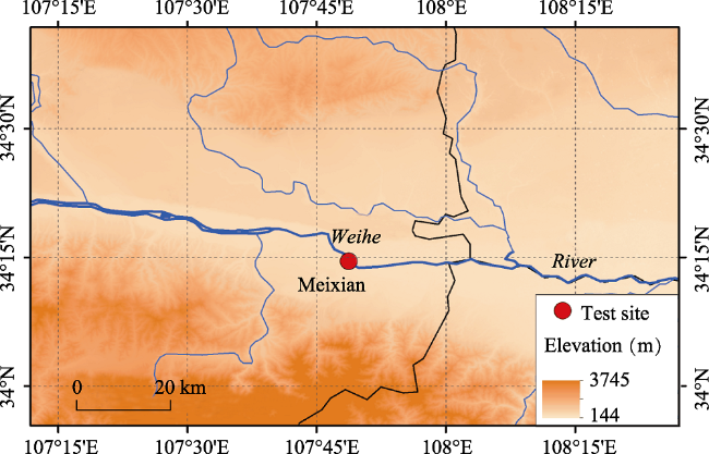
Figure 1 Map showing the location of the study area and the test site
The river has natural channel morphology with a width of 34 m and its course travels in a southwest direction in this reach, the SWP is situated in the southern river bank. The SWP is composed of three parts, the static part, the path belt and the main river channel. The streambed deposits consist primarily of loose, fluvial deposited, and gravel. The loose sediment and sand are distributed on the upper layer in the vicinity of the bank, and the gravel extensively occupies on this section of streambed. In the static part of the SWP, the sedimentary structure is mainly composed of the loose and coarse sand. The bank of the static part consists of fine to very fine sands with occasional silty areas. Fine sand extends from the surface to a depth of about 0.5 m where we found a discrete layer of sand and gravel in the bank of the river. The streambeds are relatively uniform in the upper layer of the sediment.
The experiment was carried out on 25 Jan 2015, from 11 am to 15 pm. In monitoring period, the air and water temperatures were 4.58 ± 1.70 (SD) and 5.03 ± 0.74 (SD)℃, respectively. The thermistor with the multiple depths has been used to record the sediment temperatures at the testing points (Figure 2). Temperature sensor (Heraeus, pt100) has been installed at 0.00 m, 0.10 m, 0.20 m, 0.30 m, 0.45 m, 0.60 m and 0.80 m, respectively. The measuring range of the sensor is from -50℃ to 200℃.
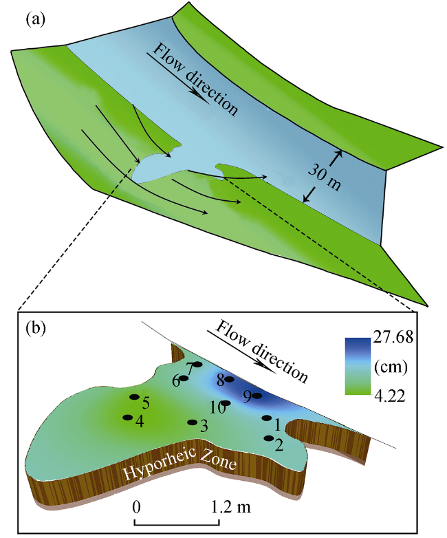
Figure 2 Map showing the measurements of the sediment temperature and water depth. (a. Position of the slack water pool; b. Description of water depth at the testing site

3 Methods

3.1 Thermal method

The one-dimensional method is a simple analytical solution that can provide an inexpensive, efficient approach to obtain accurate point estimates of HZ water exchange using streambed temperatures (Anibas et al., 2009; Irvine et al., 2015). The assumption of the HZ water exchange in SWP is just vertical directions (upward or downward), the water exchange rate can be expressed as following (Suzuki, 1960):
$\frac{K}{\rho c}\frac{{{\partial }^{2}}T(z)}{\partial {{z}^{2}}}-\frac{{{Q}_{v}}{{\rho }_{0}}{{c}_{0}}}{\rho c}\frac{dT(z)}{dz}=\frac{\partial T(z)}{\partial t}$ (1)
where T(z) is the temperature (℃) of the streambed sediments at z depth; K is the heat conductivity (J s‒1 m‒1 K‒1); ρc is the volumetric heat capacity of saturated streambed system (J m‒3 K‒1); ρ0c0 is volumetric heat capacity of the water (J m‒3 K‒1); and Qv (mm/d) is the vertical water exchange through a unit area.
When in thermal steady state conditions, the right hand of Equation (1) tends to 0 and can be arranged as:
$\frac{{{\partial }^{2}}T(z)}{\partial {{z}^{2}}}-\frac{{{Q}_{v}}{{\rho }_{0}}{{c}_{0}}}{K}\frac{dT(z)}{dz}=0$ (2)
When z = 0, the Tz=T0, and when z→∞, the Tz would be constant, then Tz=TL. And the solution of equation (2) can be expressed as (Anibas et al., 2011):
${{Q}_{v}}=\left| \frac{K}{{{\rho }_{0}}{{c}_{0}}}\ln \frac{T(z)-{{T}_{L}}}{{{T}_{0}}-{{T}_{L}}} \right|$ (3)
where Qv is the water exchange at z depth, T0 is the measurement of the temperature at the upper sediments; ρ0c0 is the volumetric heat capacity of the fluid; and TL is the constant groundwater temperature.

3.2 Determination of water exchange patterns

The water exchange pattern is determined using the conceptual diagram (Figure 3), and in this method the water-thermal transport is based on the steady state (Anibas et al., 2011). In present study, the upper sediment temperature varies with the testing sites, and the lower temperature is groundwater temperature which is constant. When the groundwater discharges the surface water, the heat would transport from deep depth to the interface between surface water and sediment, showing the upward flux. When the surface water recharges the groundwater, the heat would transport into the sediment, displaying the downward flux.
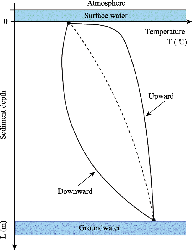
Figure 3 Conceptual diagram using vertical temperature distributional profile to determine hyporheic water exchange pattern (modified from the study by Anibas et al. (2011)

4 Results

4.1 Temperature profiles and water exchange patterns

Figure 4 summaries temperature profiles and water exchange patterns at the ten testing sites (points) within the SWP. The maximum of the sediment temperature is 8.7℃ in the 0.8 m depth at point 3; the minimum is 3.3℃ in the upper layer at the point 4. The average temperature of the upper layer and the deepest layer ranges from 5 to 8.3℃. There exists a strong upward flow from the groundwater to surface water at the points 1-3, especially at the point 1. Inversely, there exists a downward flow from the surface water to groundwater at points 5-9. However, at points 4 and 10, the water exchange pattern shows two patterns, meaning that water exchange patterns differ in depth.
Figure 4 The analysis of the temperature of the sediments and schematic diagram of hyporheic water exchange patterns in the slack water pool
The belt (e.g., the points 7-9) connects the main river channel and the body of SWP (Figure 2b). The temperature-depth profiles would represent the interactions between groundwater and stream water, which oscilloscope apparently very flexible in certain depth (about at 0.2 m), and the temperature tends to the violation of the thermal steady state assumption in this range (Conant, 2004).

4.2 Hyporheic water exchange in the SWP

Figure 5a shows the water exchange magnitude in the SWP. The water exchange can be divided into three categories: high fluxes (including points 1, 2, 3 and 4), moderate fluxes (including points 5 and 6) and low fluxes (including 7, 8, 9 and 10).
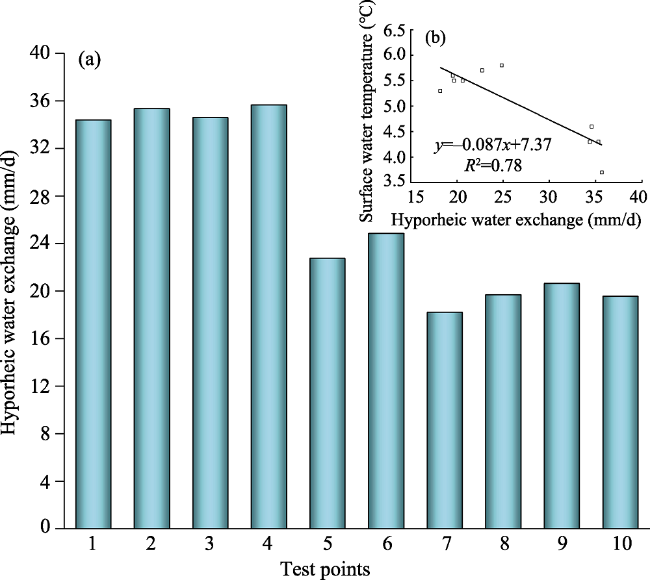
Figure 5 The hyporheic water exchange magnitude (a) and its relationship between surface water temperatures in different positions (b)
There exists a significant relationship between surface water temperatures and the water exchange magnitudes (Figure 5b), indicated by R2 = 0.78. The maximum water exchange is about 35.7 mm/d occurring at point 4, where the minimum surface water temperature of 3.7℃ is observed. The maximum surface water temperature is 5.8℃ at point 6 where the water exchange is 14.0 mm/d.

4.3 Spatial pattern of HZ water exchange within the SWP

Figure 6 shows the spatial pattern of water exchange within the SWP. There exists significant spatial pattern. Firstly, the water exchange close to the opposing flow-direction bank (points 1, 2 and 3) is stronger, and the mean of water exchange magnitude is 34.76 mm/d, about 1.6 times of the mean of 21.93 mm/d that close to the flow-direction bank (points 5, 6 and 7). Secondly, the water exchange becomes stronger when the location within the SWP is farther from the main channel.
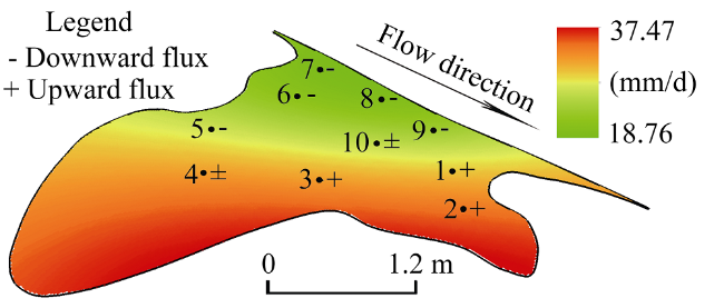
Figure 6 Spatial pattern of hyporheic water exchange within the slack water pool

5 Discussion

5.1 Temperature variations

Various elements can affect the temperature gradient changes due to the structural features of SWP, the main dynamics including spatiality of the runoff, hydraulic conductivity, and fluctuation from surface flow and wind. As an important characteristic link to the runoff, the spatial rainfall variability has impacts on the hydrogeological response (Sapriza-Azuri et al., 2015), and features directly affect the evolution of groundwater heads, and thereby influencing the surface-subsurface water exchanges (Trauth and Fleckenstein, 2017). In some regions, the intense precipitation over arid areas in a long time is associated with divergent flows (Kumar et al., 2015), when the flow merges in a catchment in a short time, and the water body in the micro-topography structures may be subject to intensive variations than normality. Meanwhile, the hydraulic gradient along the sediment-water interface is highly sensitive to the spatial structure of bedforms (Min et al., 2013; Chen et al., 2015), when the interface is influenced by the surface water flow, there would appear the fluctuation of pressure gradient, turbulent water flow from main river channel and the withdraw water into the river channel, which from the SWP edge would form a merging flow, this process would create the convection for the surface water. Furthermore, changes of minerals and grain sizes attributes in natural sediments (Rau et al., 2014) are combined with fluctuation from flow and wind, the heat rearrangement will take place within the SWP (Peralta-Maraver et al., 2018).

5.2 Drivers of water exchange pattern within the slack water pool

Two factors are potential contributors to exchange pattern in SWP: including that (1) the location in this system, and (2) the water status. There exists a series of the bends between the SWP and river bank. The water path in the subsurface can be more complicated than one direction river channel and have more direction changes, the groundwater discharge would be disturbed by this flow path. The meander bends of the stream can generate the near-stream flow paths according to their direction for the local groundwater network (Larkin and Sharp, 1992; Wroblicky et al., 1998). The location in the SWP has various meanders, hyporheic water exchange has the response to the flow variations resulted in topographic structures. For instance, some studies have revealed that the hydraulic properties of stream flow can induce the changing water exchange in the streambed and river banks (Malard et al., 2002; Tonina and Buffington, 2007; Zhang et al., 2016). The distribution of uniform groundwater flow leads to the dissolved substance variations in liquid phase and has relevance with the permeability (Koch and Nowak, 2015), so water exchange has feedback on the varieties of hydrological exchanges in river corridor.
Locations in the SWP influence the distribution of energy and create the changes of the properties in the sediment such as bubbles. Bubbles within porous media have an essential role in groundwater flow into the saturated zone (Ramirez et al., 2015). Conversely, in gaining river systems, the storm events can cause the changes of catchment size and shape, and form a temporary reversal of vertical hydraulic gradients, leading to surface water infiltration into the subsurface (Dudley-Southern and Binley, 2015), and then influence the groundwater discharge (Malcolm et al., 2006; Boano et al., 2008). However, the upwelling groundwater can block surface water infiltration (Gerecht et al., 2011), potentially reducing the nutrient attenuation capacity of the hyporheic zone (Rivett et al., 2008). The incomplete knowledge of aquifer properties under the surface water at few depths creates a problematic uncertainty (Josset et al., 2015). The groundwater table mainly influences the water body and the water flow from the river in HZ (Trauth and Fleckenstein, 2017). In the area close to the river bank, those two mechanisms would be separated by higher groundwater table generated from riparian. Another one, the flow velocity is relatively low and water status within the SWP is relatively steady. The water exchange in this condition is different from the flow individually controlled by main river channel or groundwater discharge. The water exchange gradient would be varied when the river water infiltrates this sediment system. In a period, the groundwater level is correlated to water volume and river recharge into this system. The flow of slightly compressible fluids through fractured rocks is of fundamental importance to groundwater (Kuhlman et al., 2015). The surface flow can propagate into the SWP; this may be associated with the system state and lateral sediments (Nazemi and Wheater, 2014; Wang et al., 2017).
Heterogeneity of the sediment and slope changes from the bank to the river channel would also lead to the spatial patterns of water exchange within the SWP. The complex sediment structure influences the water exchange greater than the homogeneous sediment structure (Conant Jr et al., 2004), the sediments with fine-sort particles are relatively uniform media and tend to have a good path. The sediment structure in the SWP is more heterogeneous than uniform riverbed, the sediment structure characterized by uneven spatial distribution and can drive the HZ water exchange pattern changes (Bellin et al., 2015). In the SWP, the element influencing the HZ water exchange is more variable than smooth river bank line. For instance, the vertical hydraulic conductivity is distributed spatially in different parts like in meandering riverbed (Jiang et al., 2015; Pozdniakov et al., 2016), the pore-scale processes and structures are the mechanisms leading to sediment structure changes (Schmeeckle et al., 2007). And from the distance the SWP to the main river channel, the HZ water exchange is strong near the river bank. This may be related to the pressure from the bank and the groundwater to the SWP. However, the mean particle friction does not vary systematically with bed slope in steep channels (Prancevic and Lamb, 2015). In the SWP, there exists a steep area with the rise of the river bank and forms a slop increase, the streambed sediments and the groundwater path would response to the slop within the SWP, pore in this streambed sediment subject to increase due to the decline of the water saturation degree. The water exchange process is characterized by complex spatial dynamics under the attributes of geomorphologic units (Boano et al., 2010; Doble et al., 2012), the characteristics of the sediment property and slope relative to the river bank are important for the spatiality of the HZ water exchange in the SWP (Gualtieri et al., 2017; Ianniruberto et al., 2017).

6 Implications

The challenge remaining for future work is to determine the extent to which pattern of the SWP can be most influenced by the water exchange and how to estimate this degree. Despite these compelling properties exhibited by SWP, several limitations may be attributed to the application of the one-dimensional equation. This method is more focused on the vertical exchange in this area, and the consideration for water exchange from the lateral zone is insufficient.

7 Conclusions

This study investigates the hyporheic water exchange in slack water pool using the thermal method. We found that hyporheic water exchange is mainly controlled by the location and water status in a slack water pool. There exists substantial spatial pattern on water exchange within slack water pool. River recharge dominates the water exchange in the area close to the flow-direction bank; while groundwater discharge dominates the water exchange in the area close to the opposing flow-direction bank. Furthermore, the exchange becomes stronger with the location farther from the main river channel.
The thermal approach provides an efficient method to determine the water exchange pattern, calculate the water exchange magnitude, and obtain the spatial information in some more complex geological structures. But for a slack water pool, there are some uncertainties due to the river flow and other artificial constructions such as a dam. The impact of constructions along the stream and the scale of slack water pool for the river channel have a very different influence on the results. In the future studies, care must be taken when comparing the data from the new conditions to probe more information driving the hyporheic water exchange.

Acknowledgements

We thank Guotao Zhang, Weiwei Jiang, Yuanyuan Wang, Ming Wen, Shaofeng Xu, and other members for assistance in fieldwork. In particular, we are grateful to the editor and two anonymous reviewers for providing numerous comments and suggestions, which helped improve this manuscript.

The authors have declared that no competing interests exist.

[1]
Anibas C, Buis K, Verhoeven Ret al., 2011. A simple thermal mapping method for seasonal spatial patterns of groundwater-surface water interaction.Journal of Hydrology, 397(1): 93-104.https://linkinghub.elsevier.com/retrieve/pii/S0022169410007328A simple thermal mapping method for simulating seasonal and spatial patterns of groundwater-surface water interaction is developed and tested for a segment of the Aa River, Belgium. Spatially distributed temperature profiles in the hyporheic zone of the river are measured in winter and summer seasons of three consecutive years. Inverse modeling of the one-dimensional heat transport equation is applied to estimate vertical advective fluxes using the numerical STRIVE model and an analytical model. Results of the study show that seasonal flux estimates for summer and winter can be derived with a minimum data input and simulation effort. The estimated fluxes are analyzed via non-parametric statistical tests, while spatial interpolation techniques are used to generate maps of distributed flux exchange. The estimated seepage is compared with volumetric flux obtained from piezometer measurements and output of a groundwater model. The thermal method shows higher discharge rates in winter and that the relative contribution of exfiltration to the river discharge is higher in summer. A higher flux and a more heterogeneous flow pattern are observed in the upper reach of the river compared to the lower reach. This spatial difference shows the importance of the local geomorphology and to a lesser extent the hydrogeologic setting on hyporheic flux exchange in the river. A significantly higher flux is noted on the banks than in the center of the river, which is driven by the relatively high hydraulic conductivity of the river banks. It is concluded that bank flow in groundwater-surface water interaction deserves more attention. The main channel of the Aa River alone accounts for about 15% of the total river discharge at its outlet. As the developed thermal method is cost-effective, simple and fast, it is recommended for use in identifying zones of interest in initial stages of field investigations of groundwater-surface water interaction. (C) 2010 Elsevier B.V. All rights reserved.

DOI

[2]
Anibas C, Fleckenstein J H, Volze Net al., 2009. Transient or steady-state? Using vertical temperature profiles to quantify groundwater-surface water exchange.Hydrological Processes, 23(15): 2165-2177.http://doi.wiley.com/10.1002/hyp.v23%3A15Heat is recognized as a natural tracer to identify the exchange of water between the groundwater and surface water compartment. One-dimensional (1D) heat transport models have the ability to obtain quantitative estimates of vertical fluxes through the sediment matrix. Input to these models can come from temperatures observed in the surface water and in the bed material of rivers and lakes. The upper thermal boundary condition at the groundwater-surface water interface is affected by seasonal and diurnal temperature variations. We hypothesize that effects of these transient influences are negligible at certain times of the year, such that the vertical temperature distribution can be approximated to be at steady state. Temperature time series observed over a year in the surface water and at several depths below a river in Belgium and in sediments of an acid mine lake in Eastern Germany were simulated with a heat balance model implemented in FEMME and the water and energy model VS2DH to obtain seepage fluxes. Temperature variations throughout the year at all depths could be adequately reproduced with the transient models. Vertical temperature profiles at several measuring times during the year were also fitted with an analytical, steady-state solution for 1D heat transport and the obtained fluxes compared to the results from transient simulations. Fluxes obtained from the much simpler steady-state solution were compared well with the flux rates from transient simulations for moments between mid and late summer, as well as during the winter. During transitional seasons (fall and spring), the fluxes from the steady-state solution deviated significantly from the transient estimates with a tendency to underestimate at the beginning and to overestimate towards the end of those seasons. We conclude that fitting a simple analytical solution for 1D vertical heat transport to temperature data observed at particular well-selected times of the year can provide an inexpensive, simple method to obtain accurate point estimates of groundwater-surface water exchange in rivers and lakes. Copyright 2009 John Wiley & Sons, Ltd.

DOI

[3]
Baxter C, Hauer F R, Woessner W W, 2003. Measuring groundwater-stream water exchange: New techniques for installing minipiezometers and estimating hydraulic conductivity.Transactions of the American Fisheries Society, 132(3): 493-502.http://doi.wiley.com/10.1577/1548-8659(2003)132&lt;0493:MGWENT&gt;2.0.CO;2

DOI

[4]
Bellin A, Tonina D, Marzadri A, 2015. Breakthrough curve moments scaling in hyporheic exchange.Water Resources Research, 51(2): 1112-1126.http://doi.wiley.com/10.1002/2014WR016623Abstract Groundwater-surface water exchange within the hyporheic zone is widely recognized as a key mechanism controlling the fate of nutrients within catchments. In gaining river systems, groundwater-surface water interactions are constrained by upwelling groundwater but there is increasing evidence that a rapid rise in river stage during storm events can result in a temporary reversal of vertical hydraulic gradients, leading to surface water infiltration into the subsurface and supply of surface-borne reactive solutes to this biogeochemically active interface. At a UK study site, using logged hydraulic heads in the surface water, riverbed, and riverbanks and logged electrical conductivity at multiple depths in the riverbed we show that storm events can lead to a temporary reversal of vertical hydraulic gradient with mixing evident up to 30 cm beneath the riverbed. Cross-channel variability is evident, with the center of the channel consistently having shorter reversals of hydraulic gradient, compared to the channel margins. The direction of shallow subsurface riverbank flow at the site is also reactive to storm events, temporarily aligning with the surface flow direction and then reverting back to preevent conditions. Such a transition of flow paths during events is also likely to lead to expansion of lateral hyporheic exchange. This study provides evidence that storm events can be a key driver of enhanced hyporheic exchange in gaining river systems, which may support nutrient reactions beyond the duration of event-driven change. Our observations demonstrate the dynamic nature of the hyporheic zone, which should be considered when evaluating its biogeochemical function.

DOI

[5]
Boano F, Camporeale C, Revelli Ret al., 2006. Sinuosity-driven hyporheic exchange in meandering rivers.Geophysical Research Letters, 33(18): L18406.A model for the evaluation of the intra-meander hyporheic exchange fluxes is presented. The method relies on a physically-based morphodynamic model to predict the characteristics of the flow field in a meandering river and the temporal evolution of its planimetry. The hyporheic fluxes induced at the meander scale by the river sinuosity can therefore be computed. The application of the model to a simulated case has shown the fundamental role of the river planimetry on the hyporheic exchange pattern at the meander scale, and its influence on the long-term evolution of the hyporheic exchange.

DOI

[6]
Boano F, Revelli R, Ridolfi L, 2008. Reduction of the hyporheic zone volume due to the stream-aquifer interaction.Geophysical Research Letters, 35(9): L09401.

[7]
Boano F, Revelli R, Ridolfi L, 2010. Effect of streamflow stochasticity on bedform-driven hyporheic exchange.Advances in Water Resources, 33(11): 1367-1374.https://linkinghub.elsevier.com/retrieve/pii/S0309170810000461The interactions between the stream and the geomorphologic units that compose the stream channel result in an exchange of water, heat, and chemicals that is an important component of the flows of energy and nutrients in the river ecosystem. This exchange is characterized by complex spatial and temporal dynamics that depend on the characteristics of the stream flow and morphology. At present, many studies have addressed the development of spatial patterns of hyporheic exchange that are induced by many geomorphological factors at different scales. However, much less is known about the temporal evolution of the surface&#x2013;subsurface exchange in response to the dynamics of the stream discharge. In order to investigate this problem, the present work analyzes the influence of streamflow variability on the hyporheic exchange induced by fluvial bedforms. A stochastic approach is employed to generate streamflow series whose statistical properties are representative of streams with different hydrological regimes. The resulting exchange fluxes and travel times are then computed, and the relationships between the streamflow regime and the dynamics of the exchange flux and travel times are investigated. The results show that the mean stream discharge can be used to estimate the average features of the temporal dynamics of hyporheic exchange. Moreover, exchange fluxes and residence times distributions exhibit significant fluctuations, which are tightly related to the coefficient of variation of the streamflow hydrograph.

DOI

[8]
Boulton A J, Datry T, Kasahara Tet al., 2010. Ecology and management of the hyporheic zone: Stream-groundwater interactions of running waters and their floodplains.Journal of the North American Benthological Society, 29(1): 26-40.https://www.journals.uchicago.edu/doi/10.1899/08-017.1Over the last 25 y, stream ecosystem theory has expanded to include explicitly the vertical dimension of surface roundwater linkages via the hyporheic zone and below alluvial floodplains. Hydrological exchange between the stream and hyporheic zone mediates transport of products from the biogeochemical activities within the sediments.Hot-spotsof primary productivity in the surface stream often result from upwelling nutrient-rich water. Conversely, downwelling surface water supplies organic matter and dissolved O2to hyporheic invertebrates and microbes, enhancing hyporheic productivity. Many of the papers seminal to conceptual and empirical advances in hyporheic research have been published inJ-NABS, reflecting stream benthologists awareness of the relevance of processes and biota in the hyporheic zone. However, major research gaps remain. One is the need for further empirical data to test the predictions of several current conceptual frameworks that hypothesize conditions under which the hyporheic zone might be expected to contribute most to surface stream metabolism, especially in large rivers with shallow alluvial aquifers. A second is how to apply research findings about the functional significance of the hyporheic zone to river restoration and conservation. Many activities that restore or protect surface biota and habitats probably benefit hyporheic processes and fauna as well, but this prediction should be tested. Last, hyporheic exchange and the biogeochemical processes within the sediments occur across multiple hierarchical spatial scales, but we are yet to understand fully these interactions or to extrapolate successfully across scales.J-NABSshould continue to play a significant role in publishing research on the hyporheic zone and extend the scope to include applications in river and floodplain management and restoration.

DOI

[9]
Cardenas M B, Wilson J, Zlotnik V A, 2004. Impact of heterogeneity, bed forms, and stream curvature on subchannel hyporheic exchange.Water Resources Research, 40(8): W08307.

[10]
Caruso A, Ridolfi L, Boano F, 2016. Impact of watershed topography on hyporheic exchange.Advances in Water Resources, 94: 400-411.https://linkinghub.elsevier.com/retrieve/pii/S0309170816301671Among the interactions between surface water bodies and aquifers, hyporheic exchange has been recognized as a key process for nutrient cycling and contaminant transport. Even though hyporheic exchange is strongly controlled by groundwater discharge, our understanding of the impact of the regional groundwater flow on hyporheic fluxes is still limited because of the complexity arising from the multi-scale nature of these interactions. In this work, we investigate the role of watershed topography on river-aquifer interactions by way of a semi-analytical model, in which the landscape topography is used to approximate the groundwater head distribution. The analysis of a case study shows how the complex topographic structure is the direct cause of a substantial spatial variability of the aquifer-river exchange. Groundwater upwelling along the river corridor is estimated and its influence on the hyporheic zone is discussed. In particular, the fragmentation of the hyporeic corridor induced by groundwater discharge at the basin scale is highlighted.

DOI

[11]
Chen X, Dong W, Ou Get al., 2013. Gaining and losing stream reaches have opposite hydraulic conductivity distribution patterns.Hydrology and Earth System Sciences, 17(7): 2569-2579.https://www.hydrol-earth-syst-sci.net/17/2569/2013/In gaining streams, groundwater seeps out into the streams. In losing streams, stream water moves into groundwater systems. The flow moving through the streambed sediments under these two types of hydrologic conditions is generally in opposite directions (upward vs. downward). The two opposite flow mechanisms affect the pore size and fine particle content of streambeds. Thus it is very likely that the opposite flow conditions affect the streambed hydraulic conductivity. However, comparisons of the hydraulic conductivity (K) of streambeds for losing and gaining streams are not well documented. In this study, we examined the K distribution patterns of sediments below the channel surface or stream banks for the Platte River and its tributaries in Nebraska, USA. Two contrasting vertical distribution patterns were observed from the test sites. In gaining reaches, hydraulic conductivity of the streambed decreased with the depth of the sediment cores. In losing reaches, hydraulic conductivity increased with the depth of the sediment cores. These contrasting patterns in the two types of streams were mostly attributed to flow directions during stream water and groundwater exchanges. In losing reaches, downward movement of water brought fine particle into the otherwise coarse sediment matrix, partially silting the pores. For gaining reaches, upward flow winnowed fine particles, increasing the pore spacing in the top parts of streambeds, leading to higher hydraulic conductivity in shallower parts of streambeds. These flux directions can impact K values to depths of greater than 5 m. At each study site, in situ permeameter tests were conducted to measure the K values of the shallow streambed layer. Statistical analyses indicated that K values from the sites of losing reaches were significantly different from the K values from the sites of gaining reaches.

DOI

[12]
Chen X B, Cardenas M B, Chen L, 2015. Three-dimensional versus two-dimensional bed form-induced hyporheic exchange.Water Resources Research, 51(4): 2923-2936.http://doi.wiley.com/10.1002/2014WR016848Abstract The hyporheic zone is often a critical component of river systems. Hyporheic exchange is generally forced by variation in riverbed topography such as due to bed forms. Most previous research on bed form-driven hyporheic flow has focused on two-dimensional (2-D) dunes and ripples, while little has been done on their three-dimensional (3-D) counterparts. Here we compared hyporheic exchange and associated metrics for a previously studied pair of corresponding 2-D and 3-D bed forms. To accomplish this, a series of multiphysics computational fluid dynamics models were conducted both in 2-D and 3-D with similar open channel Reynolds numbers ( Re ). Results show that the pressure gradient along the sediment-water interface is highly sensitive to the spatial structure of bed forms, which consequently determines hyporheic flow dynamics. Hyporheic flux is a function of Re for both 2-D and 3-D dunes via a power law; however, the equivalent 3-D dunes have a higher flux since the 3-D form induces more drag. The hyporheic zone depths and volumes are only slightly different with the 3-D case having a larger volume. The mean fluid residence times for both cases are related to Re by an inverse power law relationship, with the 3-D dune having smaller residence times at moderate to high Re . The effects of increasing flux on residence time in 3-D dunes are partly modulated by a slightly increasing hyporheic volume. Our results suggest that a 2-D idealization is a reasonable approximation for the more complex 3-D situation if local details are unimportant but that development of predictive models for mean fluxes and residence times, which are critical for biogeochemical processes, based on 2-D models may be insufficient.

DOI

[13]
Cheng D H, Chen X H, Huo A Det al., 2013. Influence of bedding orientation on the anisotropy of hydraulic conductivity in a well-sorted fluvial sediment.International Journal of Sediment Research, 28(1): 118-125.https://linkinghub.elsevier.com/retrieve/pii/S1001627913600244The paper describes a permeameter test method for determination of the hydraulic conductivity (K) along multi-directions in fluvial sediments with cross beddings. Unlike existing in-situ permeameter methods that determine hydraulic conductivity for submerged streambeds, our method was intended to measure hydraulic conductivity of exposed streambeds or fluvial sediments. The method was applied to the Wei River, Shaanxi Province, Central China for characterization of the anisotropy of K in a well-sorted fluvial sediment. The results illustrated that even in well-sorted sediments, cross-bedding and sediment fabrication (or texture) can lead to varied K values along different measurement directions. The K value was the largest along the dip direction (or the major direction) that is parallel to the orientation of cross bedding and the smallest in the direction perpendicular to the bedding (or the minor direction). The K value in a given direction between the major and minor direction often fell in the range bounded by the K values in the major and minor directions. The anisotropy ratio of K (the ratio of K value between the major and minor directions) in two trenches for this well-sorted fluvial sediment was up to 1.14 to 1.23, respectively. Our results also demonstrated that even for well-sorted sediments, the K values between two sampling points only about 10 cm apart can differ. It is clear that the K distribution strongly correlates to the bedding orientation.

DOI

[14]
Conant B, 2004. Delineating and quantifying ground water discharge zones using streambed temperatures.Groundwater, 42(2): 243-257.http://www.blackwell-synergy.com/toc/gwat/42/2Streambed temperature mapping, hydraulic testing using minipiezometers, and geochemical analyses of interstitial water of the streambed were used to delineate the pattern of ground water discharge in a sandy streambed and to develop a flux-based conceptual model for ground water/surface water interactions. A new and simple empirical method was used to relate fluxes obtained from minipiezometer data to streambed temperatures. The relationship allowed flux to be calculated at locations where only streambed temperature measurements were made. Slug testing and potentiomanometer measurements at 34 piezometers indicated ground water discharge ranged from 0.03 to 446 L/m 2 /day (and possibly as high as 7060 L/m 2 /day) along a 60 m long by 11 to 14 m wide reach of river. Complex but similar plan-view patterns of flux were calculated for both summer and winter using hundreds of streambed temperatures measured on a 1 by 2 m grid. The reach was dominated by ground water discharge and 5% to 7% of the area accounted for 20% to 24% of the total discharge. < 12% of the total area consisted of recharge zones or no-discharge zones. A conceptual model for ground water/surface water interactions consisting of five different behaviors was developed based on the magnitude and direction of flux across the surface of the streambed. The behaviors include short-circuit discharge (e.g., high-flow springs), high discharge (e.g., preferential flowpaths), low to moderate discharge, no discharge (e.g., horizontal hyporheic or ground water flow), and recharge. Geological variations at depth played a key role in determining which type of flow behavior occurred in the streambed.

DOI PMID

[15]
Conant Jr B, Cherry J A, Gillham R W, 2004. A PCE groundwater plume discharging to a river: Influence of the streambed and near-river zone on contaminant distributions.Journal of Contaminant Hydrology, 73(1): 249-279.https://linkinghub.elsevier.com/retrieve/pii/S0169772204000555An investigation of a tetrachloroethene (PCE) groundwater plume originating at a dry cleaning facility on a sand aquifer and discharging to a river showed that the near-river zone strongly modified the distribution, concentration, and composition of the plume prior to discharging into the surface water. The plume, streambed concentration, and hydrogeology were extensively characterized using the Waterloo profiler, mini-profiler, conventional and driveable multilevel samplers (MLS), Ground Penetrating Radar (GPR) surveys, streambed temperature mapping (to identify discharge zones), drivepoint piezometers, and soil coring and testing. The plume observed in the shallow streambed deposits was significantly different from what would have been predicted based on the characteristics of the upgradient plume. Spatial and temporal variations in the plume entering the near-river zone contributed to the complex contaminant distribution observed in the streambed where concentrations varied by factors of 100 to 5000 over lateral distances of less than 1 to 3.5 m. Low hydraulic conductivity semi-confining deposits and geological heterogeneities at depth below the streambed controlled the pattern of groundwater discharge through the streambed and influenced where the plume discharged into the river (even causing the plume to spread out over the full width of the streambed at some locations). The most important effect of the near-river zone on the plume was the extensive anaerobic biodegradation that occurred in the top 2.5 m of the streambed, even though essentially no biodegradation of the PCE plume was observed in the upgradient aquifer. Approximately 54% of the area of the plume in the streambed consisted solely of PCE transformation products, primarily cis-1,2-dichloroethene (cDCE) and vinyl chloride (VC). High concentrations in the interstitial water of the streambed did not correspond to high groundwater-discharge zones, but instead occurred in low discharge zones and are likely sorbed or retarded remnants of past high-concentration plume discharges. The high-concentration areas (up to 5529 g/l of total volatile organics) in the streambed are of ecological concern and represent potential adverse exposure locations for benthic and hyporheic zone aquatic life, but the effect of these exposures on the overall health of the river has yet to be determined. Even if the upgradient source of PCE is remediated and additional PCE is prevented from reaching the streambed, the high-concentration deposits in the streambed will likely take decades to hundreds of years to flush completely clean under natural conditions because these areas have low vertical groundwater flow velocities and high retardation factors. Despite high concentrations of contaminants in the streambed, PCE was detected in the surface water only rarely due to rapid dilution in the river and no cDCE or VC was detected. Neither the sampling of surface water nor the sampling of the groundwater from the aquifer immediately adjacent to the river gave an accurate indication of the high concentrations of PCE biodegradation products present in the streambed. Sampling of the interstitial water of the shallow streambed deposits is necessary to accurately characterize the nature of plumes discharging to rivers.

DOI PMID

[16]
Darracq A, Destouni G, Persson Ket al., 2009. Quantification of advective solute travel times and mass transport through hydrological catchments.Environmental Fluid Mechanics, 10(1/2): 103-120.http://link.springer.com/article/10.1007/s10652-009-9147-2This study has investigated and outlined the possible quantification and mapping of the distributions of advective solute travel times through hydrological catchments. These distributions are essential for understanding how local water flow and solute transport and attenuation processes affect the catchment-scale transport of solute, for instance with regard to biogeochemical cycling, contamination persistence and water quality. The spatial and statistical distributions of advective travel times have been quantified based on reported hydrological flow and mass-transport modeling results for two coastal Swedish catchments. The results show that the combined travel time distributions for the groundwater-stream network continuum in these catchments depend largely on the groundwater system and model representation, in particular regarding the spatial variability of groundwater hydraulic parameters (conductivity, porosity and gradient), and the possible contributions of slower/deeper groundwater flow components. Model assumptions about the spatial variability of groundwater hydraulic properties can thus greatly affect model results of catchment-scale solute spreading. The importance of advective travel time variability for the total mass delivery of naturally attenuated solute (tracer, nutrient, pollutant) from a catchment to its downstream water recipient depends on the product of catchment-average physical travel time and attenuation rate.

DOI

[17]
Doble R, Brunner P, McCallum Jet al., 2012. An analysis of river bank slope and unsaturated flow effects on bank storage.Groundwater, 50(1): 77-86.http://doi.wiley.com/10.1111/gwat.2012.50.issue-1Recognizing the underlying mechanisms of bank storage and return flow is important for understanding streamflow hydrographs. Analytical models have been widely used to estimate the impacts of bank storage, but are often based on assumptions of conditions that are rarely found in the field, such as vertical river banks and saturated flow. Numerical simulations of bank storage and return flow in river-aquifer cross sections with vertical and sloping banks were undertaken using a fully-coupled, surface-subsurface flow model. Sloping river banks were found to increase the bank infiltration rates by 98% and storage volume by 40% for a bank slope of 3.4 from horizontal, and for a slope of 8.5 , delay bank return flow by more than four times compared with vertical river banks and saturated flow. The results suggested that conventional analytical approximations cannot adequately be used to quantify bank storage when bank slope is less than 60 from horizontal. Additionally, in the unconfined aquifers modeled, the analytical solutions did not accurately model bank storage and return flow even in rivers with vertical banks due to a violation of the dupuit assumption. Bank storage and return flow were also modeled for more realistic cross sections and river hydrograph from the Fitzroy River, Western Australia, to indicate the importance of accurately modeling sloping river banks at a field scale. Following a single wet season flood event of 12 m, results showed that it may take over 3.5 years for 50% of the bank storage volume to return to the river.

DOI PMID

[18]
Dochartaigh B, MacDonald A, Archer N et al., 2012. Groundwater-surface water interaction in an upland hillslope-floodplain environment, Eddleston, Scotland, BHS 11th National Symposium, Hydrology for a Changing World, Dundee,Scotland, pp. 2012.

[19]
Dudley-Southern M, Binley A, 2015. Temporal responses of groundwater-surface water exchange to successive storm events.Water Resources Research, 51(2): 1112-1126.http://doi.wiley.com/10.1002/2014WR016623Abstract Groundwater-surface water exchange within the hyporheic zone is widely recognized as a key mechanism controlling the fate of nutrients within catchments. In gaining river systems, groundwater-surface water interactions are constrained by upwelling groundwater but there is increasing evidence that a rapid rise in river stage during storm events can result in a temporary reversal of vertical hydraulic gradients, leading to surface water infiltration into the subsurface and supply of surface-borne reactive solutes to this biogeochemically active interface. At a UK study site, using logged hydraulic heads in the surface water, riverbed, and riverbanks and logged electrical conductivity at multiple depths in the riverbed we show that storm events can lead to a temporary reversal of vertical hydraulic gradient with mixing evident up to 30 cm beneath the riverbed. Cross-channel variability is evident, with the center of the channel consistently having shorter reversals of hydraulic gradient, compared to the channel margins. The direction of shallow subsurface riverbank flow at the site is also reactive to storm events, temporarily aligning with the surface flow direction and then reverting back to preevent conditions. Such a transition of flow paths during events is also likely to lead to expansion of lateral hyporheic exchange. This study provides evidence that storm events can be a key driver of enhanced hyporheic exchange in gaining river systems, which may support nutrient reactions beyond the duration of event-driven change. Our observations demonstrate the dynamic nature of the hyporheic zone, which should be considered when evaluating its biogeochemical function.

DOI

[20]
Dunster K, 2011. Dictionary of Natural Resource Management. UBC Press.http://www.cabdirect.org/abstracts/19971901708.htmlDefinitions are given and cross-referenced for >6000 natural resource management terms, including illustrations and a detailed set of appendices covering the classification of organisms, geological time scales, and conversion factors.

[21]
Fischer H, Kloep F, Wilzcek Set al., 2005. A river's liver-microbial processes within the hyporheic zone of a large lowland river.Biogeochemistry, 76(2): 349-371.http://link.springer.com/10.1007/s10533-005-6896-yLittle is known on microbial activities in the sediments of large lowland rivers despite of their potentially high influence on biogeochemical budgets. Based on field measurements in a variety of sedimentary habitats typical for a large lowland river (Elbe, Germany), we present results on the abundance and production of sedimentary bacteria, the potential activity of a set of extracellular enzymes, and potential nitrification and denitrification rates. A diving bell was used to access the sediments in the central river channel, enabling us to sample down to 1 m sediment depth. Depth gradients of all measures of microbial activity were controlled by sediment structure, hydraulic conditions, as well as by the supply with organic carbon and nitrogen. Microbial heterotrophic activity was tightly coupled with the availability of carbon and nitrogen, whereas chemolithotrophic activity (nitrification rate) was related to the available surface area of particles. In the central bed of the river, bacterial production and extracellular enzyme activity remained high down to the deepest sediment layers investigated. Due to the large inner surface area and their connectivity with the surface water, the shifting sediments in the central channel of the river were microbially highly active There, vertically integrated bacterial production amounted to 0.95 g C$\text{m}^{-3}\text{h}^{-1}$, which was 2.9 to 5.5 times higher than in the nearshore habitats. We conclude that carbon and nitrogen cycling in the river is controlled by the live sediments of the central river channel, which thus represent a "liver function" in the river's metabolism.

DOI

[22]
Fox A, Boano F, Arnon S, 2014. Impact of losing and gaining streamflow conditions on hyporheic exchange fluxes induced by dune-shaped bed forms.Water Resources Research, 50(3): 1895-1907.http://doi.wiley.com/10.1002/2013WR014668

DOI

[23]
Frei S, Lischeid G, Fleckenstein J H, 2010. Effects of micro-topography on surface-subsurface exchange and runoff generation in a virtual riparian wetland: A modeling study.Advances in Water Resources, 33(11): 1388-1401.https://linkinghub.elsevier.com/retrieve/pii/S0309170810001417In humid upland catchments wetlands are often a prominent feature in the vicinity of streams and have potential implications for runoff generation and nutrient export. Wetland surfaces are often characterized by distinct micro-topography (hollows and hummocks). The effects of such micro-topography on surface–subsurface exchange and runoff generation for a 10 by 20 m synthetic section of a riparian wetland were investigated in a virtual modeling experiment. A reference model with a planar surface was run for comparison. The geostatistically simulated structure of the micro-topography replicates the topography of a peat-forming riparian wetland in a small mountainous catchment in South-East Germany (Lehstenbach). Flow was modeled with the fully-integrated surface–subsurface code HydroGeoSphere. Simulation results showed that the specific structure of the wetland surface resulted in distinct shifts between surface and subsurface flow dominance. Surface depressions filled and started to drain via connected channel networks in a threshold controlled process, when groundwater levels intersected the land surface. These networks expanded and shrunk in a spill and fill mechanism when the shallow water table fluctuated around the mean surface elevation under variable rainfall inputs. The micro-topography efficiently buffered rainfall inputs and produced a hydrograph that was characterized by subsurface flow during most of the year and only temporarily shifted to surface flow dominance (> 80% of total discharge) during intense rainstorms. In contrast the hydrograph in the planar reference model was much “flashier” and more controlled by surface runoff. A non-linear, hysteretic relationship between groundwater level and discharge observed at the study site was reproduced with the micro-topography model. Hysteresis was also observed in the relationship between surface water storage and discharge, but over a relatively narrow range of surface water storage values. Therefore it was concluded that surface water storage was a better predictor for the occurrence of surface runoff than groundwater levels.

DOI

[24]
Gerecht K E, Cardenas M B, Guswa A Jet al., 2011. Dynamics of hyporheic flow and heat transport across a bed-to-bank continuum in a large regulated river.Water Resources Research, 47: W03524.http://onlinelibrary.wiley.com/doi/10.1029/2010WR009794/pdfThe lower Colorado River (LCR) near Austin, Texas is heavily regulated for hydropower generation. Daily water releases from a dam located 23 km upstream of our study site in the LCR caused the stage to fluctuate by more than 1.5 m about a mean depth of 1.3 m. As a result, the river switches from gaining to losing over a dam storage-release cycle, driving exchange between river water and groundwater. We assessed the hydrologic impacts of this by simultaneous temperature and head monitoring across a bed-to-bank transect. River-groundwater exchange flux is largest close to the bank and decreases away from the bank. Correspondingly, both the depth of the hyporheic zone and the exchange time are largest close to the bank. Adjacent to the bank, the streambed head response is hysteretic, with the hysteresis disappearing with distance from the bank, indicating that transient bank storage affects the magnitude and direction of vertical exchange close to the bank. Pronounced changes in streambed temperature are observed down to a meter. When the river stage is high, which coincides with when the river is coldest, downward advection of heat from a previous cycles' warm-water pulse warms the streambed. When the river is at its lowest stage but warmest temperature, upwelling groundwater cools the streambed. Future research should consider and focus on a more thorough understanding of the impacts of dam regulation on the hydrologic, thermal, biogeochemical, and ecologic dynamics of rivers and their hyporheic and riparian zones.

DOI

[25]
Gualtieri C, Filizola Jr N, Oliveira Met al., 2017. A field study of the confluence between Negro and Solimões rivers. Part 1: Hydrodynamics and sediment transport.Comptes Rendus Geoscience, 350(1/2): 31-42.http://www.sciencedirect.com/science/article/pii/S1631071317301220Confluences are a common feature of riverine systems, where are located converging flow streamlines and potential mixing of separate flows. The confluence of the Negro and Solim es Rivers ranks among the largest on Earth and its study may provide some general insights into large confluence dynamics and processes. An investigation was recently conducted about that confluence in both low and high-flow conditions using acoustic Doppler velocity profiling (ADCP), water quality sampling and high-resolution seismic data. First, the study gained insights into the characterization of the basic hydrodynamics parameters about the confluence as well as of those affecting sediments transport. Second, the analysis of the results showed that common hydrodynamic features noted in previous confluence studies were herein observed. Finally, some differences between low-flow and relatively high-flow conditions about the transfer of momentum from the Solim es to the Negro side of the Amazon Channel were identified.

DOI

[26]
Ianniruberto M, Trevethan M, Pinheiro Aet al., 2017. A field study of the confluence between Negro and Solimões rivers. Part 2: Bed morphology and stratigraphy.Comptes Rendus Geoscience, 350(1/2): 43-54.http://www.sciencedirect.com/science/article/pii/S1631071317301608The confluence of the Negro and Solim es Rivers is an interesting study area under several points of view: it represents the second largest river confluence of the Amazon Basin; the rivers are characterized by very distinct hydrologic behaviour; and it is situated in a peculiar tectonic setting. A field investigation was undertaken to study the characteristics of this confluence, aiming to better understand the bed morphology and stratigraphy resulting from the complex interaction of geological setting, hydrodynamics, and sediment load. Two field campaigns were carried out, during low- and high-flow conditions, using high-resolution seismic, echosounding, and acoustic Doppler current profiling. A third campaign was carried out just in a limited area of the confluence, with a multi-beam echosounder. The results of these surveys provided a more detailed view of the geology, morphology and sediment distribution about the confluence.

DOI

[27]
Irvine D J, Lautz L K, Briggs M Aet al., 2015. Experimental evaluation of the applicability of phase, amplitude, and combined methods to determine water flux and thermal diffusivity from temperature time series using VFLUX 2.Journal of Hydrology, 531: 728-737.https://linkinghub.elsevier.com/retrieve/pii/S0022169415008252Vertical fluid exchange between surface water and groundwater can be estimated using diurnal signals from temperature time series methods based on amplitude ratios (Ar), phase shifts (Δ01), or combined use of both (ArΔ01). TheAr, Δ01, andArΔ01methods are typically applied in conditions where one or more of their underlying assumptions are violated, and the reliability of the various methods in response to non-ideal conditions is unclear. Additionally,ArΔ01methods offer the ability to estimate thermal diffusivity (κe) without assuming any thermal parameters, although the value of such output has not been broadly tested. TheAr, Δ01, andArΔ01methods are tested under non-steady, 1D flows in sand column experiments, and multi-dimensional flows in heterogeneous media in numerical modeling experiments. Results show that, in non-steady flow conditions, estimatedκevalues outside of a plausible range for streambed materials (0.028–0.180m2d611) coincide with time periods with erroneous flux estimates. In heterogeneous media, sudden changes ofκewith depth also coincide with erroneous flux estimates. When (known) fluxes are variable in time, poor identification of Δ01leads to poor flux estimates from Δ01andArΔ01methods. However, when fluxes are steady, or near zero,ArΔ01methods provide the most accurate flux estimates. This comparison ofAr, Δ01andArΔ01methods under non-ideal conditions provides guidance on their use. In this study,ArΔ01methods have been coded into a new version of VFLUX, allowing users easy access to recent advances in heat tracing.

DOI

[28]
Isiorho S A, Meyer J H, 1999. The effects of bag type and meter size on seepage meter measurements.Groundwater, 37(3): 411-413.http://www.blackwell-synergy.com/toc/gwat/37/3Seepage meters provide a useful, inexpensive method of measuring seepage flux through unconsolidated sediments in lakes, reservoirs, and stream channels. In the literature, the bag type used is usually not indicated, and its effect on seepage measurement has not been evaluated. The effects of bag type and seepage meter size have been evaluated in a laboratory setting. A sandbox 100.4 (L) 76.2 (W) 24 (H) cm size was half filled with coarse sand and water to a depth of 10 cm. Four seepage meters and two bag types (balloon and condom) were used in the seepage measurements. There was no significant difference between the seepage measurements obtained from the two bag types. A two-sample t-test (df=56, Wt-sat=2.58, alpha=0.01, p=0.0013) failed to reject the null hypothesis of similarity between measurements from the two bag types. The seepage measurements from four seepage meters were similar with no significant difference; however, the smaller diameter seepage meters had a greater variance.

DOI

[29]
Jiang W, Song J, Zhang Jet al., 2015. Spatial variability of streambed vertical hydraulic conductivity and its relation to distinctive stream morphologies in the Beiluo River, Shaanxi Province, China.Hydrogeology Journal, 23(7): 1617-1626.http://link.springer.com/10.1007/s10040-015-1288-4Geomorphology; Streambed vertical hydraulic conductivity; Erosion and deposition; Groundwater/surface-water relations; China

DOI

[30]
Josset L, Ginsbourger D, Lunati I, 2015. Functional error modeling for uncertainty quantification in hydrogeology.Water Resources Research, 51(2): 1050-1068.http://doi.wiley.com/10.1002/2014WR016028Abstract Approximate models (proxies) can be employed to reduce the computational costs of estimating uncertainty. The price to pay is that the approximations introduced by the proxy model can lead to a biased estimation. To avoid this problem and ensure a reliable uncertainty quantification, we propose to combine functional data analysis and machine learning to build error models that allow us to obtain an accurate prediction of the exact response without solving the exact model for all realizations. We build the relationship between proxy and exact model on a learning set of geostatistical realizations for which both exact and approximate solvers are run. Functional principal components analysis (FPCA) is used to investigate the variability in the two sets of curves and reduce the dimensionality of the problem while maximizing the retained information. Once obtained, the error model can be used to predict the exact response of any realization on the basis of the sole proxy response. This methodology is purpose-oriented as the error model is constructed directly for the quantity of interest, rather than for the state of the system. Also, the dimensionality reduction performed by FPCA allows a diagnostic of the quality of the error model to assess the informativeness of the learning set and the fidelity of the proxy to the exact model. The possibility of obtaining a prediction of the exact response for any newly generated realization suggests that the methodology can be effectively used beyond the context of uncertainty quantification, in particular for Bayesian inference and optimization.

DOI

[31]
Kalbus E, Reinstorf F, Schirmer M, 2006. Measuring methods for groundwater-surface water interactions: A review.Hydrology and Earth System Sciences, 10(6): 873-887.http://www.hydrol-earth-syst-sci.net/10/873/2006/

DOI

[32]
Kasahara T, Wondzell S M, 2003. Geomorphic controls on hyporheic exchange flow in mountain streams. Water Resources Research, 39(1): SBH 3-1-SBH 3-14.http://onlinelibrary.wiley.com/doi/10.1029/2002WR001386/fullHyporheic exchange flows were simulated using MODFLOW and MODPATH to estimate relative effects of channel morphologic features on the extent of the hyporheic zone, on hyporheic exchange flow, and on the residence time of stream water in the hyporheic zone. Four stream reaches were compared in order to examine the influence of stream size and channel constraint. Within stream reaches, the influence of pool-step or pool-riffle sequences, channel sinuosity, secondary channels, and channel splits was examined. Results showed that the way in which channel morphology controlled exchange flows differed with stream size and, in some cases, with channel constraint. Pool-step sequences drove hyporheic exchange in the second-order sites, creating exchange flows with relatively short residence times. Multiple features interacted to drive hyporheic exchange flow in the unconstrained fifth-order site, where pool-riffle sequences and a channel split created exchange flows with short residence times, whereas a secondary channel created exchange flows with long residence times. There was relatively little exchange flow in the bedrock-constrained fifth-order site. Groundwater flow models were effective in examining the morphologic features that controlled hyporheic exchange flow, and surface-visible channel morphologic features controlled the development of the hyporheic zone in these mountain streams.

DOI

[33]
Koch J, Nowak W, 2015. Predicting DNAPL mass discharge and contaminated site longevity probabilities: Conceptual model and high-resolution stochastic simulation.Water Resources Research, 51: 806-831.http://doi.wiley.com/10.1002/2014WR015478Abstract Improper storage and disposal of nonaqueous-phase liquids (NAPLs) has resulted in widespread contamination of the subsurface, threatening the quality of groundwater as a freshwater resource. The high frequency of contaminated sites and the difficulties of remediation efforts demand rational decisions based on a sound risk assessment. Due to sparse data and natural heterogeneities, this risk assessment needs to be supported by appropriate predictive models with quantified uncertainty. This study proposes a physically and stochastically coherent model concept to simulate and predict crucial impact metrics for DNAPL contaminated sites, such as contaminant mass discharge and DNAPL source longevity. To this end, aquifer parameters and the contaminant source architecture are conceptualized as random space functions. The governing processes are simulated in a three-dimensional, highly resolved, stochastic, and coupled model that can predict probability density functions of mass discharge and source depletion times. While it is not possible to determine whether the presented model framework is sufficiently complex or not, we can investigate whether and to which degree the desired model predictions are sensitive to simplifications often found in the literature. By testing four commonly made simplifications, we identified aquifer heterogeneity, groundwater flow irregularity, uncertain and physically based contaminant source zones, and their mutual interlinkages as indispensable components of a sound model framework.

DOI

[34]
Korbel K L, Hose G C, 2015. Habitat, water quality, seasonality, or site? Identifying environmental correlates of the distribution of groundwater biota.Freshwater Science, 34(1): 329-343.https://www.journals.uchicago.edu/doi/10.1086/680038The distribution of biota in aquatic ecosystems, including aquifers, is collectively influenced by habitat structure, water quality, seasonality, and local variations in environmental conditions. However, little is known about the nature and relative influences of such factors in groundwater ecosystems. Our aims were to identify the key environmental variables influencing the distribution of biota within the Gwydir River alluvial aquifer in northwestern New South Wales, Australia, and to consider the relative importance of environmental variables, in terms of habitat structure, water quality, seasonality, and site attributes, to both microbial and invertebrate (stygofauna) assemblages. Stygofauna distribution was primarily influenced by habitat variables (predominantly sediment structure) followed by site variables (abundance of trees), with water quality and seasonality having relatively little influence. These results indicate that it is the aquifer conditions relating to habitat structure, water flow, and the supply of organic matter that are most important for determining stygofauna distribution. Microbial assemblage structure was not strongly correlated with habitat variables, possibly because habitat restraints do not exist because of their smaller size. Instead, seasonality and water-quality variables had the greatest influence on microbial assemblages. Microbes might respond to seasonal (particularly rainfall induced) changes in water quality more quickly than do stygofauna, which may explain the relatively greater importance of seasonality and water quality to microbial assemblages. Given that stygofauna are most influenced by habitat and site variables, and microbial assemblages are most influenced by seasonality and water quality, disturbance to any of these factors may threaten the stability and integrity of the groundwater ecosystem.

DOI

[35]
Kuhlman KL, Malama B, Heath J E, 2015. Multiporosity flow in fractured low-permeability rocks.Water Resources Research, 51(2): 848-860.http://doi.wiley.com/10.1002/2014WR016502

DOI

[36]
Kumar K N, Entekhabi D, Molini A, 2015. Hydrological extremes in hyperarid regions: A diagnostic characterization of intense precipitation over the Central Arabian Peninsula.Journal of Geophysical Research: Atmospheres, 120: 1637-1650.Aridity is typically associated with deep and dry daytime boundary layers, stable nighttime stratification, divergent flows, and limited large-scale moisture advection. All these factors are paramount in regulating the hydroclimatology of hyperarid regions, resulting in extremely intermittentand often intenselocal precipitation patterns. However, the link between synoptic-scale forcing and intense precipitation over arid regions has been scarcely investigated in the literature and still remains exceedingly unexplored. We present here a diagnostic study of intense precipitation in the Central Arabian Peninsula, based on the analysis of local extreme signatures embedded in synoptic patterns. Special emphasis is given to the genesis of winter extremes over the Peninsula, and to possible effects of synchronization between the atmospheric circulation over the Mediterranean and the Indian Ocean. Based on composites of the tropospheric circulation for a large ensemble of intense events, we show that moisture necessary to trigger winter extremes over the Peninsula starts to build up in average 8 days before heavy rainfall occurrence, mainly as a consequence of the interplay between the Mediterranean and the Monsoonal circulation. Moisture advection is in turn associated with an upper troposphere cyclonic circulation and pronounced potential vorticity intrusions. Overall, our results demonstrate how large-scale precursors can be effectively used to improve the predictability of rainfall extremes in hyperarid regions.

DOI

[37]
Larkin R G, Sharp J M, 1992. On the relationship between river-basin geomorphology, aquifer hydraulics, and ground-water flow direction in alluvial aquifers.Geological Society of America Bulletin, 104(12): 1608-1620.https://pubs.geoscienceworld.org/gsabulletin/article/104/12/1608-1620/182633Not Available

DOI

[38]
Lautz L K, Siegel D I, 2006. Modeling surface and ground water mixing in the hyporheic zone using MODFLOW and MT3D.Advances in Water Resources, 29(11): 1618-1633.https://linkinghub.elsevier.com/retrieve/pii/S0309170805002939We used a three-dimensional MODFLOW model, paired with MT3D, to simulate hyporheic zones around debris dams and meanders along a semi-arid stream. MT3D simulates both advective transport and sink/source mixing of solutes, in contrast to particle tracking (e.g. MODPATH), which only considers advection. We delineated the hydrochemically active hyporheic zone based on a new definition, specifically as near-stream subsurface zones receiving a minimum of 10% surface water within a 10-day travel time. Modeling results indicate that movement of surface water into the hyporheic zone is predominantly an advective process. We show that debris dams are a key driver of surface water into the subsurface along the experimental reach, causing the largest flux rates of water across the streambed and creating hyporheic zones with up to twice the cross-sectional area of other hyporheic zones. Hyporheic exchange was also found in highly sinuous segments of the experimental reach, but flux rates are lower and the cross-sectional areas of these zones are generally smaller. Our modeling approach simulated surface and ground water mixing in the hyporheic zone, and thus provides numerical approximations that are more comparable to field-based observations of surface鈥揼roundwater exchange than standard particle-tracking simulations.

DOI

[39]
Li Q, Song J X, Wei Aet al., 2013. Changes in major factors affecting the ecosystem health of the Weihe River in Shaanxi Province, China.Frontiers of Environmental Science & Engineering, 7(6): 875-885.http://link.springer.com/article/10.1007/s11783-013-0568-2Maintenance of the ecosystem health of a river is of great importance for local sustainable development. On the basis of both qualitative and quantitative analysis of the influence of natural variations and human activities on the ecosystem function of the Weihe River, the changes in major factors affecting its ecosystem health are determined, which include: 1) Deficiency of environment flow: since the 1960s, the incoming stream flow shows an obvious decreasing tendency. Even in the low flow period, 80% of the water in the stream is impounded by dams for agriculture irrigation in the Baoji district. As a result, the water flow maintained in the stream for environmental use is very limited. 2) Deterioration of water quality: the concentrations of typical pollutants like Chemical Oxygen Demand (COD) and NH3-N are higher than their maximum values of the Chinese environmental quality standard. Very few fish species can survive in the River. 3) Deformation of water channels: the continuous channel sedimentation has resulted in the decrease in stream gradient, shrinkage of riverbed and the decline in the capability for flood discharge. 4) Loss of riparian vegetation: most riparian land has been occupied by urban construction activities, which have caused the loss of riparian vegetation and biodiversity and further weakened flood control and water purification functions.

DOI

[40]
Malard F, Tockner K, Dole-Olivier M Jet al., 2002. A landscape perspective of surface-subsurface hydrological exchanges in river corridors.Freshwater Biology, 47(4): 621-640.http://doi.wiley.com/10.1046/j.1365-2427.2002.00906.x

DOI

[41]
Malcolm I A, Soulsby C, Youngson A F, 2006. High-frequency logging technologies reveal state-dependent hyporheic process dynamics: Implications for hydroecological studies.Hydrological Processes, 20(3): 615-622.http://doi.wiley.com/10.1002/%28ISSN%291099-1085

DOI

[42]
Marzadri A, Tonina D, McKean J Aet al., 2014. Multi-scale streambed topographic and discharge effects on hyporheic exchange at the stream network scale in confined streams.Journal of Hydrology, 519: 1997-2011.https://linkinghub.elsevier.com/retrieve/pii/S0022169414007689The hyporheic zone is the volume of the streambed sediment mostly saturated with stream water. It is the transitional zone between stream and shallow-ground waters and an important ecotone for benthic species, including macro-invertebrates, microorganisms, and some fish species that dwell in the hyporheic zone for parts of their lives. Most hyporheic analyses are limited in scope, performed at the reach scale with hyporheic exchange mainly driven by one mechanism, such as interaction between flow and ripples or dunes. This research investigates hyporheic flow induced by the interaction of flow and streambed topography at the valley-scale under different discharges. We apply a pumping based hyporheic model along a 37km long reach of the Deadwood River for different flow releases from Deadwood Reservoir and at different discharges of its tributaries. We account for dynamic head variations, induced by interactions of small-scale topography and flow, and piezometric head variations, caused by reach-scale bathymetry low interactions. We model the dynamic head variations as those caused by dune-like bedforms and piezometric heads with the water surface elevation predicted with a 1-dimensional, 1D, hydraulic model supported by close-spaced cross-sections extracted every channel width from high-resolution bathymetry. Superposition of these two energy-head components provides the boundary condition at the water ediment interface for the hyporheic model. Our results show that small- and large-scale streambed features induce fluxes of comparable magnitude but the former and the latter dominate fluxes with short and long residence times, respectively. In our setting, stream discharge and alluvium thickness have limited effects on hyporheic processes including the thermal regime of the hyporheic zone. Bed topography is a strong predictor of hyporheic exchange and the 1D wavelet is a convenient way to describe the bed topography quantitatively. Thus wavelet power could be a good index for hyporheic potential, with areas of high and low wavelet power coinciding with high and low hyporheic fluxes, respectively.

DOI

[43]
Mendoza-Lera C, Datry T, 2017. Relating hydraulic conductivity and hyporheic zone biogeochemical processing to conserve and restore river ecosystem services.Science of the Total Environment, 579: 1815-1821.https://linkinghub.elsevier.com/retrieve/pii/S0048969716326316Abstract River management practices commonly attempt to improve habitat and ecological functioning (e.g. biogeochemical processing or retention of pollutants) by restoring hydrological exchange with the hyporheic zone (i.e. hyporheic flow) in an effort to increase mass transfer of solutes (nutrients, carbon and electron acceptors such as oxygen or nitrate). However, even when hyporheic flow is increased, often no significant changes in biogeochemical processing are detected. Some of these apparent paradox result from the simplistic assumption that there is a direct relationship between hyporheic flow and biogeochemical processing. We propose an alternative conceptual model that hyporheic flow is non-linearly related with biogeochemical processing. Based on the different solute mass transfer and area available for colonization among hydraulic conductivities, we hypothesize that biogeochemical processing in the hyporheic zone follows a Gaussian function depending on hyporheic hydraulic conductivity. After presenting the conceptual model and its domain of application, we discuss the potential implications, notably for river restoration and further hyporheic research. Copyright 2016 Elsevier B.V. All rights reserved.

DOI PMID

[44]
Min L L, Yu J J, Liu C Met al., 2013. The spatial variability of streambed vertical hydraulic conductivity in an intermittent river, northwestern China.Environmental Earth Sciences, 69(3): 873-883.http://link.springer.com/10.1007/s12665-012-1973-8Streambed vertical hydraulic conductivity ( K) plays an important role in river water and groundwater interaction. The K at the ten transects (Ts1-Ts10) at the Donghe River (an intermittent river) in the Ejina Basin, northwestern China, was measured to investigate its spatial variation. Based on the sediment characteristics and vertical hydraulic conductivity of the riverbed, the entire riverbed of the Donghe River could be divided arbitrarily into two parts: an upper part (starting at Ts1 and ending at Ts9, without an obvious and continuous clogging layer) and a lower part (the remaining riverbed, with an obvious and continuous clogging layer). In the upper part, although the K varied with depth within the 0-30 cm layer, the variability with depth could be ignored in practice. The arithmetic mean K of the upper part ranged from 12 to 27.6 m/day, three orders of magnitude larger than that of the lower part (0.06 m/day). The change of K along the river cross section was significant, and larger values of K often occurred in the parts of the channels with greater water depth. However, there were no consistent patterns of the variability of K at transects across the river, which was influenced by the variation in streambed characteristics. The results could be useful for the estimation of groundwater recharge from river and groundwater resources evaluation in the Ejina Basin.

DOI

[45]
Naiman R J, Latterell J J, 2005. Principles for linking fish habitat to fisheries management and conservation.Journal of Fish Biology, 67: 166-185.http://blackwell-synergy.com/doi/abs/10.1111/jfb.2005.67.issue-sB

DOI

[46]
Nazemi A, Wheater H S, 2014. How can the uncertainty in the natural inflow regime propagate into the assessment of water resource systems?Advances in Water Resources, 63: 131-142.https://linkinghub.elsevier.com/retrieve/pii/S0309170813002406The Canadian Rocky Mountain headwaters support the water resource systems of the Canadian Prairies. Significant variations in natural headwater contributions have been observed due to warming climate. Projecting future natural headwater flows under climate change effects, however, has large uncertainty. First, there are difficulties in climate modeling and downscaling in alpine regions. Second, streamflow modeling in mountainous areas is extremely challenging. There is therefore a need to understand the effects of uncertainty in the natural inflow regime, and in particular how this translates into uncertainty in representing the state and the outflow of water resource systems. Considering the Oldman River basin in Alberta, Canada, we synthesized different inflow regimes based on site/inter-site properties of the historical inflow regime. The water resources system was then conditioned on the synthesized inflow regimes to identify the mechanisms of error propagation from the headwater streamflows to the water allocations. The results show that the response of the water resource system to the uncertainty in the generated inflow regime depends on the system state, flow condition and the component of interest. Generally, the response of the reservoirs to the uncertainty in the estimated inflow regime is more significant in dry years, in particular during low flow conditions. The response at the system outlet is rather different, as the propagation of the headwater uncertainty is more significant during high flow conditions. Also, similar inflow estimates in terms of error and uncertainty may result in different error and uncertainty estimates in the simulated outflows; therefore, lower bias and uncertainty in estimating the regional inflow regime does not necessarily mean lower bias and uncertainty in simulating the streamflow at the outlet of the system. Our results provide improved understanding of uncertainty propagation through complex water resource systems, but also portray the need for better climate and hydrological modeling in the Rocky Mountains for improved water management in the Canadian Prairies, particularly in the face of uncertain climate futures. This will be crucial if the natural headwater inflows decline and/or the system faces drought conditions.

DOI

[47]
Peralta-Maraver I, Reiss J, Robertson A L, 2018. Interplay of hydrology, community ecology and pollutant attenuation in the hyporheic zone.Science of the Total Environment, 610/611: 267-275.https://linkinghub.elsevier.com/retrieve/pii/S004896971732034Xreact-text: 163 Four Middle Eocene orthoclad species, Heterotrissocladius naibuchi sp. n., Paraphaenocladius nadezhdae sp. n., Pseudosmittia kodrulae sp. n. and Smittia sukachevae sp. n.. are described and figured. Based on the combination of the diptera fauna composition and paleobotanical data, suggestions on the climate and habitats of the Sakhalin amber forest are given. /react-text react-text: 164 /react-text

DOI PMID

[48]
Pozdniakov S P, Wang P, Lekhov M V, 2016. A semi-analytical generalized Hvorslev formula for estimating riverbed hydraulic conductivity with an open-ended standpipe permeameter.Journal of Hydrology, 540: 736-743.https://linkinghub.elsevier.com/retrieve/pii/S0022169416304231The well-known Hvorslev (1951) formula was developed to estimate soil permeability using single-well slug tests and has been widely applied to determine riverbed hydraulic conductivity using in situ standpipe permeameter tests. Here, we further develop a general solution of the Hvorslev (1951) formula that accounts for flow in a bounded medium and assumes that the bottom of the river is a prescribed head boundary. The superposition of real and imaginary disk sources is used to obtain a semi-analytical expression of the total hydraulic resistance of the flow in and out of the pipe. As a result, we obtained a simple semi-analytical expression for the resistance, which represents a generalization of the Hvorslev (1951). The obtained expression is benchmarked against a finite-element numerical model of 2-D flow (inr-zcoordinates) in an anisotropic medium. The results exhibit good agreement between the simulated and estimated riverbed hydraulic conductivity values. Furthermore, a set of simulations for layered, stochastically heterogeneous riverbed sediments was conducted and processed using the proposed expression to demonstrate the potential associated with measuring vertical heterogeneity in bottom sediments using a series of standpipe permeameter tests with different lengths of pipe inserted into the riverbed sediments.

DOI

[49]
Prancevic J P, Lamb M P, 2015. Particle friction angles in steep mountain channels.Journal of Geophysical Research: Earth Surface, 120(2): 242-259.http://onlinelibrary.wiley.com/doi/10.1002/2014JF003286/pdfAbstract Sediment transport rates in steep mountain channels are typically an order of magnitude lower than predicted by models developed for lowland rivers. One hypothesis for this observation is that particles are more stable in mountain channels due to particle-particle interlocking or bridging across the channel width. This hypothesis has yet to be tested, however, because we lack direct measurements of particle friction angles in steep mountain channels. Here we address this data gap by directly measuring the minimum force required to dislodge sediment (pebbles to boulders) and the sediment weight in mountain channels using a handheld force gauge. At eight sites in California, with reach-averaged bed angles ranging from 0.5° to 23° and channel widths ranging from 265m to 1665m, we show that friction angles in natural streams average 68° and are 16° larger than those typically measured in laboratory experiments, which is likely due to particle interlocking and burial. Results also show that larger grains are disproportionately more stable than predicted by existing models and that grains organized into steps are twice as stable as grains outside of steps. However, the mean particle friction angle does not vary systematically with bed slope. These results do not support systematic increases in friction angle in steeper and narrower channels to explain the observed low sediment transport rates in mountain channels. Instead, the spatial pattern and grain-size dependence of particle friction angles may indirectly lower transport rates in steep, narrow channels by stabilizing large clasts and channel-spanning steps, which act as momentum sinks due to form drag.

DOI

[50]
Ramirez J A, Baird A J, Coulthard T Jet al., 2015. Testing a simple model of gas bubble dynamics in porous media.Water Resources Research, 51(2): 1036-1049.http://doi.wiley.com/10.1002/2014WR015898Abstract Bubble dynamics in porous media are of great importance in industrial and natural systems. Of particular significance is the impact that bubble-related emissions (ebullition) of greenhouse gases from porous media could have on global climate (e.g., wetland methane emissions). Thus, predictions of future changes in bubble storage, movement, and ebullition from porous media are needed. Methods exist to predict ebullition using numerical models, but all existing models are limited in scale (spatial and temporal) by high computational demands or represent porous media simplistically. A suitable model is needed to simulate ebullition at scales beyond individual pores or relatively small collections ( 4</sup> m3) of connected pores. Here we present a cellular automaton model of bubbles in porous media that addresses this need. The model is computationally efficient, and could be applied over large spatial and temporal extent without sacrificing fine-scale detail. We test this cellular automaton model against a physical model and find a good correspondence in bubble storage, bubble size, and ebullition between both models. It was found that porous media heterogeneity alone can have a strong effect on ebullition. Furthermore, results from both models suggest that the frequency distributions of number of ebullition events per time and the magnitude of bubble loss are strongly right skewed, which partly explains the difficulty in interpreting ebullition events from natural systems.

DOI

[51]
Rau G C, Andersen M S, McCallum A Met al., 2014. Heat as a tracer to quantify water flow in near-surface sediments.Earth-Science Reviews, 129: 40-58.https://linkinghub.elsevier.com/retrieve/pii/S0012825213001876The dynamic distribution of thermal conditions present in saturated near-surface sediments have been widely utilised to quantify the flow of water. A rapidly increasing number of papers demonstrate that heat as a tracer is becoming an integral part of the toolbox used to investigate water flow in the environment. We summarise the existing body of research investigating natural and induced heat transport, and analyse the progression in fundamental and natural process understanding through the qualitative and quantitative use of heat as a tracer. Heat transport research in engineering applications partly overlaps with heat tracing research in the earth sciences but is more advanced in the fundamental understanding. Combining the findings from both areas can enhance our knowledge of the heat transport processes and highlight where research is needed. Heat tracing relies upon the mathematical heat transport equation which is subject to certain assumptions that are often neglected. This review reveals that, despite the research efforts to date, the capability of the Fourier-model applied to conductive鈥揷onvective heat transport in water saturated natural materials has not yet been thoroughly tested. However, this is a prerequisite for accurate and meaningful heat transport modelling with the purpose of increasing our understanding of flow processes at different scales. This review reveals several knowledge gaps that impose significant limitations on practical applications of heat as a tracer of water flow. The review can be used as a guide for further research directions on the fundamental as well as the practical aspects of heat transport on various scales from the lab to the field.

DOI

[52]
Rivett M O, Buss S R, Morgan Pet al., 2008. Nitrate attenuation in groundwater: A review of biogeochemical controlling processes.Water Research, 42(16): 4215-4232.https://linkinghub.elsevier.com/retrieve/pii/S0043135408002984Biogeochemical processes controlling nitrate attenuation in aquifers are critically reviewed. An understanding of the fate of nitrate in groundwater is vital for managing risks associated with nitrate pollution, and to safeguard groundwater supplies and groundwater-dependent surface waters. Denitrification is focused upon as the dominant nitrate attenuation process in groundwater. As denitrifying bacteria are essentially ubiquitous in the subsurface, the critical limiting factors are oxygen and electron donor concentration and availability. Variability in other environmental conditions such as nitrate concentration, nutrient availability, pH, temperature, presence of toxins and microbial acclimation appears to be less important, exerting only secondary influences on denitrification rates. Other nitrate depletion mechanisms such as dissimilatory nitrate reduction to ammonium and assimilation of nitrate into microbial biomass are unlikely to be important in most subsurface settings relative to denitrification. Further research is recommended to improve current understanding on the influence of organic carbon, sulphur and iron electron donors, physical restrictions on microbial activity in dual porosity aquifers, influences of environmental condition (e.g. pH in poorly buffered environments and salinity in coastal or salinized soil settings), co-contaminant influences (particularly the contrasting inhibitory and electron donor influences of pesticides) and improved quantification of denitrification rates in the laboratory and field.

DOI PMID

[53]
Sapriza-Azuri G, Jódar J, Navarro Vet al., 2015. Impacts of rainfall spatial variability on hydrogeological response.Water Resources Research, 51(2): 1112-1126.http://doi.wiley.com/10.1002/2014WR016623Abstract Groundwater-surface water exchange within the hyporheic zone is widely recognized as a key mechanism controlling the fate of nutrients within catchments. In gaining river systems, groundwater-surface water interactions are constrained by upwelling groundwater but there is increasing evidence that a rapid rise in river stage during storm events can result in a temporary reversal of vertical hydraulic gradients, leading to surface water infiltration into the subsurface and supply of surface-borne reactive solutes to this biogeochemically active interface. At a UK study site, using logged hydraulic heads in the surface water, riverbed, and riverbanks and logged electrical conductivity at multiple depths in the riverbed we show that storm events can lead to a temporary reversal of vertical hydraulic gradient with mixing evident up to 30 cm beneath the riverbed. Cross-channel variability is evident, with the center of the channel consistently having shorter reversals of hydraulic gradient, compared to the channel margins. The direction of shallow subsurface riverbank flow at the site is also reactive to storm events, temporarily aligning with the surface flow direction and then reverting back to preevent conditions. Such a transition of flow paths during events is also likely to lead to expansion of lateral hyporheic exchange. This study provides evidence that storm events can be a key driver of enhanced hyporheic exchange in gaining river systems, which may support nutrient reactions beyond the duration of event-driven change. Our observations demonstrate the dynamic nature of the hyporheic zone, which should be considered when evaluating its biogeochemical function.

DOI

[54]
Schmeeckle M W, Nelson J M, Shreve R L, 2007. Forces on stationary particles in near-bed turbulent flows.Journal of Geophysical Research, 112(F2): F02003.http://onlinelibrary.wiley.com/doi/10.1029/2006JF000536/full[1] In natural flows, bed sediment particles are entrained and moved by the fluctuating forces, such as lift and drag, exerted by the overlying flow on the particles. To develop a better understanding of these forces and the relation of the forces to the local flow, the downstream and vertical components of force on near-bed fixed particles and of fluid velocity above or in front of them were measured synchronously at turbulence-resolving frequencies (200 or 500 Hz) in a laboratory flume. Measurements were made for a spherical test particle fixed at various heights above a smooth bed, above a smooth bed downstream of a downstream-facing step, and in a gravel bed of similarly sized particles as well as for a cubical test particle and 7 natural particles above a smooth bed. Horizontal force was well correlated with downstream velocity and not correlated with vertical velocity or vertical momentum flux. The standard drag formula worked well to predict the horizontal force, but the required value of the drag coefficient was significantly higher than generally used to model bed load motion. For the spheres, cubes, and natural particles, average drag coefficients were found to be 0.76, 1.36, and 0.91, respectively. For comparison, the drag coefficient for a sphere settling in still water at similar particle Reynolds numbers is only about 0.4. The variability of the horizontal force relative to its mean was strongly increased by the presence of the step and the gravel bed. Peak deviations were about 30% of the mean force for the sphere over the smooth bed, about twice the mean with the step, and 4 times it for the sphere protruding roughly half its diameter above the gravel bed. Vertical force correlated poorly with downstream velocity, vertical velocity, and vertical momentum flux whether measured over or ahead of the test particle. Typical formulas for shear-induced lift based on Bernoulli's principle poorly predict the vertical forces on near-bed particles. The measurements suggest that particle-scale pressure variations associated with turbulence are significant in the particle momentum balance.

DOI

[55]
Schmidt C, Conant Jr B, Bayer-Raich Met al., 2007. Evaluation and field-scale application of an analytical method to quantify groundwater discharge using mapped streambed temperatures.Journal of Hydrology, 347(3): 292-307.https://linkinghub.elsevier.com/retrieve/pii/S0022169407004787A method for calculating groundwater discharge through a streambed on a sub-reach to a reach scale has been developed using data from plan-view mapping of streambed temperatures at a uniform depth along a reach of a river or stream. An analytical solution of the one-dimensional steady-state heat-diffusion鈥揳dvection equation was used to determine fluxes from observed temperature data. The method was applied to point measurements of streambed temperatures used to map a 60 m long reach of a river by Conant Jr. [Conant Jr. B., 2004. Delineating and quantifying ground water discharge zones using streambed temperatures. Ground Water 42(2), 243鈥257] and relies on the underlying assumption that streambed temperatures are in a quasi-steady-state during the period of mapping. The analytical method was able to match the values and pattern of flux previously obtained using an empirical relationship that related streambed temperatures to fluxes obtained from piezometers and using Darcy鈥檚 law. A second independent test of the analytical method using temperature mapping and seepage meter fluxes along a first-order stream confirmed the validity of the approach. The USGS numerical heat transport model VS2DH was also used to evaluate the thermal response of the streambed sediments to transient variations in surface water temperatures and showed that quasi-steady-state conditions occurred for most, but not all, conditions. During mapping events in the winter, quasi-steady-state conditions were typically observed for both high and low groundwater discharge conditions, but during summer mapping events quasi-steady-state conditions were typically not achieved at low flux areas or where measurements were made at shallow depths. Major advantages of using this analytical method include: it can be implemented using a spreadsheet; it does not require the installation or testing of piezometers or seepage meters (although they would help to confirm the results); and it needs only a minimal amount of input data related to water temperatures and the thermal properties of water and the sediments. The field results showed the analytical solution tends to underestimate high fluxes. However, a sensitivity analysis of possible model inputs shows the solution is relatively robust and not particularly sensitive to small uncertainties in input data and can produce reasonable flux estimates without the need for calibration.

DOI

[56]
Somogyvári M, Bayer P, Brauchler R, 2016. Travel-time-based thermal tracer tomography.Hydrology and Earth System Sciences, 20(5): 1885-1901.https://www.hydrol-earth-syst-sci.net/20/1885/2016/Active thermal tracer testing is a technique to get information about the flow and transport properties of an aquifer. In this paper we propose an innovative methodology using active thermal tracers in a tomographic setup to reconstruct cross-well hydraulic conductivity profiles. This is facilitated by assuming that the propagation of the injected thermal tracer is mainly controlled by advection. To reduce the effects of density and viscosity changes and thermal diffusion, early-time diagnostics are used and specific travel times of the tracer breakthrough curves are extracted. These travel times are inverted with an eikonal solver using the staggered grid method to reduce constraints from the pre-defined grid geometry and to improve the resolution. Finally, non-reliable pixels are removed from the derived hydraulic conductivity tomograms. The method is applied to successfully reconstruct cross-well profiles as well as a 3-D block of a high-resolution fluvio-aeolian aquifer analog data set. Sensitivity analysis reveals a negligible role of the injection temperature, but more attention has to be drawn to other technical parameters such as the injection rate. This is investigated in more detail through model-based testing using diverse hydraulic and thermal conditions in order to delineate the feasible range of applications for the new tomographic approach.

DOI

[57]
Song J X, Zhang G T, Wang W Zet al., 2017. Variability in the vertical hyporheic water exchange effected by hydraulic conductivity and river morphology at a natural confluent meander bend. Hydrological Processes, 31(19): 3407-3420.

[58]
Stegen J C, Johnson T, Fredrickson J Ket al., 2018. Influences of organic carbon speciation on hyporheic corridor biogeochemistry and microbial ecology.Nat. Commun., 9(1): 585.http://www.nature.com/articles/s41467-018-02922-9Abstract The hyporheic corridor (HC) encompasses the river-groundwater continuum, where the mixing of groundwater (GW) with river water (RW) in the HC can stimulate biogeochemical activity. Here we propose a novel thermodynamic mechanism underlying this phenomenon and reveal broader impacts on dissolved organic carbon (DOC) and microbial ecology. We show that thermodynamically favorable DOC accumulates in GW despite lower DOC concentration, and that RW contains thermodynamically less-favorable DOC, but at higher concentrations. This indicates that GW DOC is protected from microbial oxidation by low total energy within the DOC pool, whereas RW DOC is protected by lower thermodynamic favorability of carbon species. We propose that GW-RW mixing overcomes these protections and stimulates respiration. Mixing models coupled with geophysical and molecular analyses further reveal tipping points in spatiotemporal dynamics of DOC and indicate important hydrology-biochemistry-microbial feedbacks. Previously unrecognized thermodynamic mechanisms regulated by GW-RW mixing may therefore strongly influence biogeochemical and microbial dynamics in riverine ecosystems.

DOI PMID

[59]
Storey R G, Howard K W F, Williams D D, 2003. Factors controlling riffle-scale hyporheic exchange flows and their seasonal changes in a gaining stream: A three-dimensional groundwater flow model.Water Resources Research, 39(2): 1034.

[60]
Stubbington R, 2012. The hyporheic zone as an invertebrate refuge: A review of variability in space, time, taxa and behaviour.Marine and Freshwater Research, 63(4): 293-311.http://www.publish.csiro.au/?paper=MF11196

DOI

[61]
Suzuki S, 1960. Percolation measurements based on heat flow through soil with special reference to paddy fields.Journal of Geophysical Research, 65(9): 2883-2885.http://doi.wiley.com/10.1029/JZ065i009p02883A new method is presented for the determination of the in situ percolation rate in soil based on the influence percolating water has on the heat flow through soil.

DOI

[62]
Tonina D, Buffington J M, 2007. Hyporheic exchange in gravel bed rivers with pool-riffle morphology: Laboratory experiments and three-dimensional modeling.Water Resources Research, 43(1): W01421.http://www.fs.usda.gov/treesearch/pubs/download/26785.pdfExp1 Exp2 Exp3 Exp4 Exp5 Exp6 Exp7 Exp8 Exp9 Exp10 Exp11 Exp12

DOI

[63]
Trauth N, Fleckenstein J H, 2017. Single discharge events increase reactive efficiency of the hyporheic zone.Water Resources Research, 53(1): 779-798.http://doi.wiley.com/10.1002/2016WR019488In this study, we investigate the impact of single stream discharge events on water exchange, solute transport, and reactions in the hyporheic zone below a natural in-stream gravel bar. We set up a reactive transport groundwater model with streamflow scenarios that vary by event duration and peak discharge. A steady ambient groundwater flow field is assumed that results in losing, neutral, or gaining stream conditions depending on the stream stage. Across the streambed dissolved oxygen, organic carbon, and nitrate are transported into the subsurface. Additional nitrate is received from upwelling groundwater. Aerobic respiration and denitrification are simulated for scenarios with different stream solute concentrations. Results show that hyporheic exchange flux, solute transport, and consumption increase during events. However, their intensities depend highly on the interplay between event characteristics and ambient groundwater conditions. During events where reversals in the hydraulic gradient occur stream water and solutes infiltrate deeper into the aquifer where they have more time to react. For those events, the reactive efficiency of the hyporheic zone (solute consumption as fraction of influx) for aerobic respiration and denitrification is up to 2.7 and 10 times higher compared to base flow conditions. The fraction of stream nitrate load consumed in the hyporheic zone increases with stream discharge (up to 150 mg/m/h), but remains below the value under base flow conditions for weak events. Events also increase denitrification of groundwater borne nitrate, but groundwater nitrate flux to the stream decreases by up to 33% due to temporary gradient reversals.

DOI

[64]
Vogt T, Schirmer M, Cirpka O A, 2012. Investigating riparian groundwater flow close to a losing river using diurnal temperature oscillations at high vertical resolution.Hydrology and Earth System Sciences, 16(2): 473-487.https://www.hydrol-earth-syst-sci.net/16/473/2012/

DOI

[65]
Wang P, Pozdniakov S P, Vasilevskiy P Y, 2017. Estimating groundwater-ephemeral stream exchange in hyper-arid environments: Field experiments and numerical simulations.Journal of Hydrology, 555: 68-79.https://linkinghub.elsevier.com/retrieve/pii/S0022169417306686Surface water infiltration from ephemeral dryland streams is particularly important in hyporheic exchange and biogeochemical processes in arid and semi-arid regions. However, streamflow transmission losses can vary significantly, partly due to spatiotemporal variations in streambed permeability. To extend our understanding of changes in streambed hydraulic properties, field investigations of streambed hydraulic conductivity were conducted in an ephemeral dryland stream in north-western China during high and low streamflow periods. Additionally, streamflow transmission losses were numerically estimated using combined stream and groundwater hydraulic head data and stream and streambed temperature data. An analysis of slug test data at two different river flow stages (one test was performed at a low river stage with clean water and the other at a high river stage with muddy water) suggested that sedimentation from fine-grained particles, i.e., physical clogging processes, likely led to a reduction in streambed hydraulic properties. To account for the effects of streambed clogging on changes in hydraulic properties, an iteratively increasing total hydraulic resistance during the slug test was considered to correct the estimation of streambed hydraulic conductivity. The stream and streambed temperature can also greatly influence the hydraulic properties of the streambed. One-dimensional coupled water and heat flux modelling with HYDRUS-1D was used to quantify the effects of seasonal changes in stream and streambed temperature on streamflow losses. During the period from 6 August 2014 to 4 June 2015, the total infiltration estimated using temperature-dependent hydraulic conductivity accounted for approximately 88% of that using temperature-independent hydraulic conductivity. Streambed clogging processes associated with fine particle settling/wash up cycles during flow events, and seasonal changes in streamflow temperature are two considerable factors that affect water infiltration in ephemeral dryland streams. Our results show that time series measurements of stream and sediment temperature and surface and groundwater head can be used to effectively determine the seasonal dynamics of streambed water exchange. Such combined heat and head monitoring at field sites is useful for calibrating regional surface-groundwater models. The results of this study may provide insights into hyporheic exchange in ephemeral dryland streams.

DOI

[66]
Wang W Z, Song J X, Zhang G Tet al., 2018. The influence of hyporheic upwelling fluxes on inorganic nitrogen concentrations in the pore water of the Weihe River.Ecological Engineering, 112: 105-115.https://linkinghub.elsevier.com/retrieve/pii/S0925857417306456Hyporheic zone is an important region of nitrogen removal in river systems. Hyporheic exchange generally leads to heterogeneous redox environments, which are conducive to nitrogen transformation. This study seeks to determine the influence of hyporheic upwelling fluxes on inorganic nitrogen (NH4+, NO3-, and NO2-) concentrations in the sediment pore water of the Weihe River, China. The patterns and magnitudes of hyporheic water exchange on 12 August 2016 were derived by a one-dimensional heat transport model, and inorganic nitrogen concentrations in the pore water, surface water, and groundwater were obtained. The results indicated that hyporheic water exchange was characterized by upwelling at each point during the test period. Moreover, NH4+ dominated the hyporheic zone from 0 to 45 cm, likely due to organic nitrogen mineralization. Additionally, a non-linear relationship was observed between NH4+ concentrations and upwelling fluxes. This relationship was derived by analyzing the effect of upwelling on biogeochemical activity and nitrogen transformation. Notably, increasing upwelling fluxes less than 400 mm/d resulted in high NH4+ concentrations, whereas fluxes exceeding 400 mm/d led to low NH4+ concentrations. Overall, the variations in inorganic nitrogen associated with hyporheic water exchange are of great importance for controlling nitrogen pollution and maintaining sustainable health in river systems.

DOI

[67]
Westhoff M C, Gooseff M N, Bogaard T Aet al., 2011. Quantifying hyporheic exchange at high spatial resolution using natural temperature variations along a first-order stream.Water Resources Research, 47(10): W10508.http://onlinelibrary.wiley.com/doi/10.1029/2010WR009767/fullHyporheic exchange is an important process that underpins stream ecosystem function, and there have been numerous ways to characterize and quantify exchange flow rates and hyporheic zone size. The most common approach, using conservative stream tracer experiments and 1-D solute transport modeling, results in oversimplified representations of the system. Here we present a new approach to quantify hyporheic exchange and the size of the hyporheic zone (HZ) using high-resolution temperature measurements and a coupled 1-D transient storage and energy balance model to simulate in-stream water temperatures. Distributed temperature sensing was used to observe in-stream water temperatures with a spatial and temporal resolution of 2 and 3 min, respectively. The hyporheic exchange coefficient (which describes the rate of exchange) and the volume of the HZ were determined to range between 0 and 2.7 10sand 0 and 0.032 mm, respectively, at a spatial resolution of 1-10 m, by simulating a time series of in-stream water temperatures along a 565 m long stretch of a small first-order stream in central Luxembourg. As opposed to conventional stream tracer tests, two advantages of this approach are that exchange parameters can be determined for any stream segment over which data have been collected and that the depth of the HZ can be estimated as well. Although the presented method was tested on a small stream, it has potential for any stream where rapid (in regard to time) temperature change of a few degrees can be obtained.

DOI

[68]
Wroblicky G J, Campana M E, Valett H Met al., 1998. Seasonal variation in surface-subsurface water exchange and lateral hyporheic area of two stream-aquifer systems.Water Resources Research, 34(3): 317-328.http://doi.wiley.com/10.1029/97WR03285We used two-dimensional unconfined transient groundwater flow models to investigate the interface between stream and groundwater flow systems, or hyporheic zone, of two first-order streams that drain catchments with distinctly different alluvial sediments and bedrock lithology. Particle tracking showed that lateral hyporheic area (planimetric area of flow paths lateral to the stream that are recharged by and return to the stream with travel times of 10 days or less) differed between the two study streams and varied with discharge within each system. At the Rio Calaveras (welded tuff), lateral hyporheic area ranged from 1.7 to 4 mover the annual cycle. In the Aspen Creek system (sandstone), lateral hyporheic area (1-1.5 m) was restricted to roughly half of that observed at Rio Calaveras. The size of the hyporheic zone lateral to the streams at both sites decreased by approximately 50% during high flows. Sensitivity analyses indicated that changes in the hydraulic conductivity of alluvial and streambed sediments and variation in recharge rates have greatest impact on the magnitude, direction, and spatial distribution of stream-groundwater exchange.

DOI

[69]
Zhang G T, Song J X, Wen Met al., 2017. Effect of bank curvatures on hyporheic water exchange at meter scale.Hydrology Research, 48(2): 355-369.https://iwaponline.com/hr/article/48/2/355-369/1915

DOI

Outlines

/