
Journal of Geographical Sciences >
Evolution of the gravel-bedded anastomosing river within the Qihama reach of the First Great Bend of the Yellow River
Author: Gao Chao, Master Candidate, specialized in fluvial geomorphology. E-mail: gaoc.15s@igsnrr.ac.cn
Received date: 2017-12-15
Accepted date: 2018-03-09
Online published: 2019-02-25
Supported by
National Natural Science Foundation of China, No.41571005, No.41271027
Copyright
The anastomosing river that is present within the First Great Bend of the Yellow River is different from other sand-bedded rivers of this type because it contains gravel-bedded materials. It is therefore important to determine whether, or not, the specific characteristics of this anastomosing river are similar to those seen in sand-bedded forms, including the characteristics of erosion and deposition, and the stability of channel and interchannel wetlands. Four Landsat images from 1990, 2001, 2013, and 2016 alongside two Google Earth (GE) images from 2011 and 2013 were utilized in this study in tandem with field sampling and observations to select a 12 km main channel length section of the Qihama reach anastomosing river. This section was then used to determine variations in channel planform and sedimentary characteristics over a 26 year period. The results of this study show that this gravel-bedded anastomosing river has exhibited a high degree of stability overall, and that there has been no obvious channel and wetland bank erosion and deposition. Data also show that over the 26 years of this study, anastomosing belt area increased by 2.43%, while the ratio of land to water area remained almost equal. The number of wetlands has also increased along this river section at a rate as high as 62.16% because of the fragmentation of some small interchannel examples, while the talweg has alternately migrated to either the left or right over long periods of time at a relatively stable rate. Indeed, as a result of the migration of this line, there has been significant turnover in the number of islands within the main channel while bank shift has occurred at a rate of about 5 m/yr. The numerous anastomosing channels within this river section remained very stable over the course of this study, characterized by a mean annual migration rate of just 1 m/yr, while the sediments in bank columnar sections are mainly composed of fine sands or silts with a relatively high clay content. The sediment grain-size distribution curve for this river section contains multiple peaks, distinct from the muddy sediments within bank columnar sections from sand-bedded anastomosing rivers. The dense vegetation within riparian and interchannel wetlands alongside this river reach has also protected anastomosing channels from erosion and maintained their stability, a key feature of this gravel-bedded system.
Key words: gravel-bedded anastomosing river; anastomosing belt; wetlands; talweg; sediments; Yellow River
GAO Chao , WANG Suiji . Evolution of the gravel-bedded anastomosing river within the Qihama reach of the First Great Bend of the Yellow River[J]. Journal of Geographical Sciences, 2019 , 29(2) : 306 -320 . DOI: 10.1007/s11442-019-1598-x
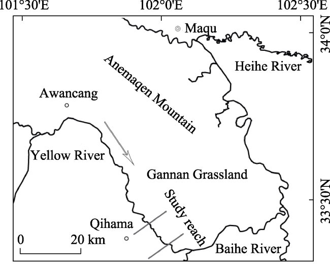
Figure 1 Map showing the location of the river reach discussed in this study |
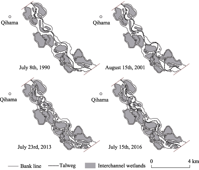
Figure 2 Channel planforms in different years within the river reach studied in this paper |
Table 1 Geometric parameters of channel planforms in different years |
| Date of image captured | Talweg length (km) | Sinuosity | Area of the anastomosing belt (km2) | Land area (km2) | Water area (km2) | Number of wetlands |
|---|---|---|---|---|---|---|
| July 8th, 1990 | 11.43 | 1.21 | 16.89 | 8.12 | 8.77 | 37 |
| August 15th, 2001 | 12.83 | 1.36 | 17.00 | 8.27 | 8.73 | 40 |
| July 23rd, 2013 | 12.72 | 1.35 | 17.17 | 9.12 | 8.05 | 60 |
| July 15th, 2016 | 12.18 | 1.29 | 17.30 | 9.11 | 8.19 | 60 |
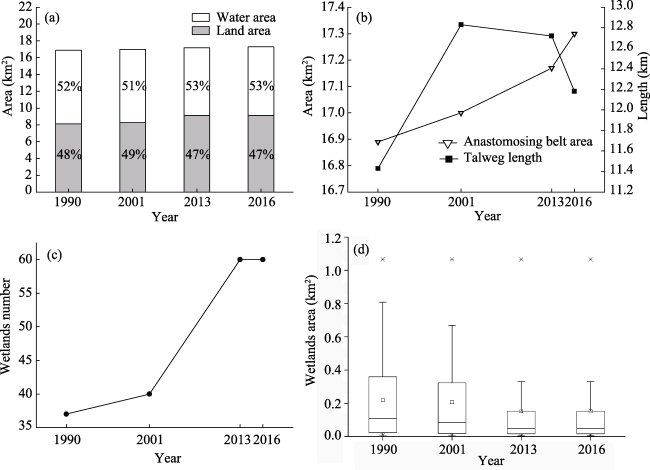
Figure 3 The relative proportions of water and land area (a), variations in anastomosing belt area and talweg length (b), variations in the number of interchannel wetlands (c), and the area of interchannel wetlands within the river reach studied in this paper (d) |
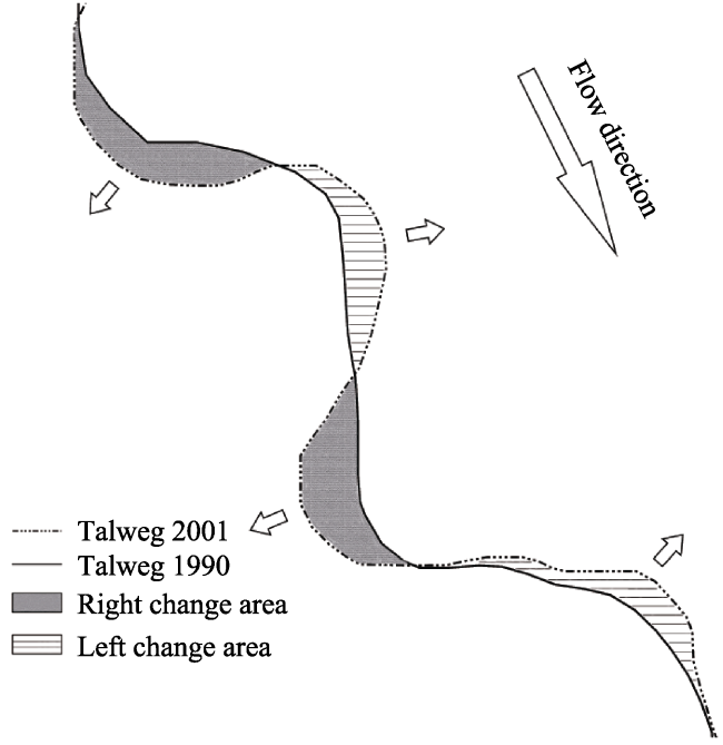
Figure 4 Cartoon showing change in area with talweg migration to either the left or right over time |
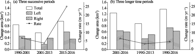
Figure 5 Changes in area caused by talweg migration within different time periods and the mean annual rate of change within the river reach studied in this paper |
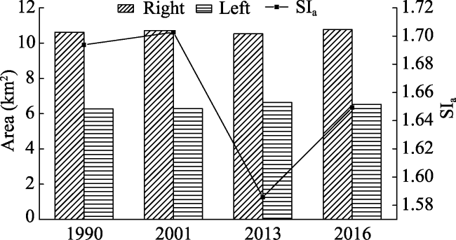
Figure 6 Comparison of symmetry index values for the anastomosing belt in different years |
Table 2 The locations of field work sites and the characteristics of columnar sections on the channel banks of the Qihama reach of the anastomosing river in 2016 |
| Site | Observation date | Latitude | Longitude | Channel and sediment characteristics |
|---|---|---|---|---|
| QP25 | April 26th | 33°22′51″N | 102°01′20″E | The upper layer of the left main channel bank at this site is composed mainly of fine sand and silt, while the lower layer below 75 cm is gravel. |
| QP26 | April 30th | 33°22′33″N | 102°00′36″E | The width of the right anastomosing channel is 60 m, the water width is 30 m, and the water depth is 1 m at this location. The bank height is 2 m, with 1 m mud layer on the top and 1m gravel layer on the bottom. The mean size of gravel is between 6 cm and 7 cm, ranging up to a maximum of 10 cm. |
| QP27 | April 30th | 33°22′43″N | 102°00′40″E | The main channel width at this site is about 200 m and comprises two gravel bars in the center and one gravel bar adjacent to the right bank which had been eroded about 1 m. |
| QP28 | April 30th | 33°22′46″N | 102°00′36″E | The width of the anastomosing channel adjacent to the main channel at this site is 15 m and an upward extending gravel bar with a maximum width of 30 m is next to the left bank of the main channel. The right bank at this site is about 1.6 m high and has a 1 m mud layer on the top and a 0.6 m gravel layer on its base. A large number of trees on the right bank were fallen, indicating that this right bank was washed back. |
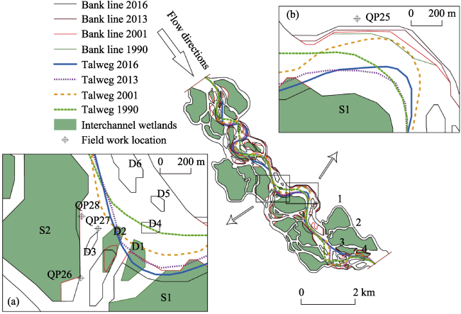
Figure 7 Changes in the talweg, interchannel wetlands, and banks within typical sections of the study river reach |
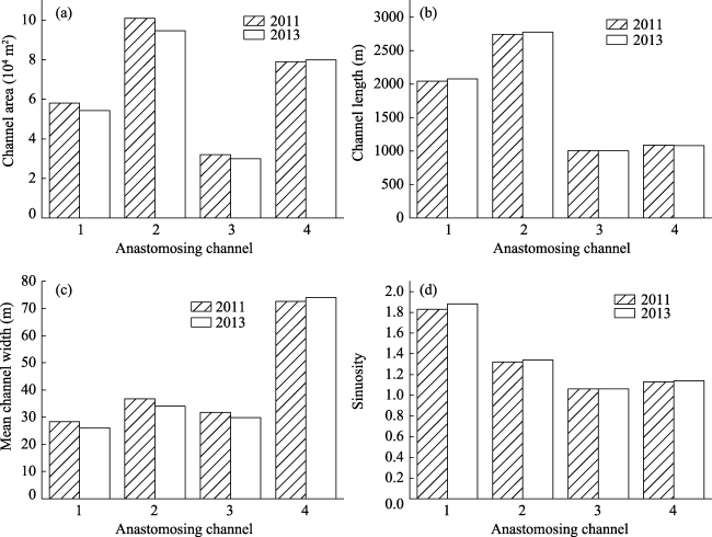
Figure 8 Comparison of the four anastomosing channel planforms within the river reach of the study area between 2011 and 2013 |
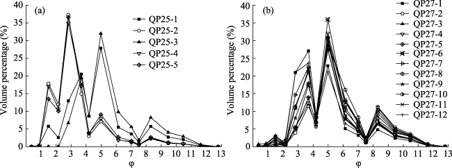
Figure 9 Percentage distribution curves for different grain sizes within the bank columnar sections QP25 (a) and QP27 (b) |
The authors have declared that no competing interests exist.
| [1] |
|
| [2] |
|
| [3] |
|
| [4] |
|
| [5] |
|
| [6] |
|
| [7] |
|
| [8] |
|
| [9] |
|
| [10] |
|
| [11] |
|
| [12] |
|
| [13] |
|
| [14] |
|
| [15] |
|
| [16] |
|
| [17] |
|
| [18] |
|
| [19] |
|
| [20] |
|
| [21] |
|
| [22] |
|
| [23] |
|
| [24] |
|
| [25] |
|
| [26] |
|
| [27] |
|
| [28] |
|
| [29] |
|
| [30] |
|
| [31] |
|
| [32] |
|
| [33] |
|
| [34] |
|
| [35] |
|
| [36] |
|
| [37] |
|
| [38] |
|
| [39] |
|
| [40] |
|
| [41] |
|
| [42] |
|
| [43] |
|
| [44] |
|
| [45] |
|
| [46] |
|
/
| 〈 |
|
〉 |