Research Articles

Rural settlement spatial patterns and effects:Road traffic accessibility and geographic factors in Guangdong Province, China

  • YANG Ren , 1 ,
  • XU Qian , 2, * ,
  • XU Xuanfang 1 ,
  • CHEN Yanchun 1
Expand
  • 1. School of Geography and Planning, Sun Yat-sen University, Guangzhou 510275, China
  • 2. Guangzhou Institute of Geography, Guangzhou 510070, China
* Corresponding author: Xu Qian (1984-), PhD, specialized in land science and ecological environment assessment and effects. E-mail:

Author: Yang Ren (1984-), PhD and Associate Professor, specialized in rural geography and land science. E-mail:

Received date: 2018-01-22

  Accepted date: 2018-03-26

  Online published: 2019-02-25

Supported by

National Natural Science Foundation of China, No.41401190, No.41871177, No.41801088

Science and Technology Program of Guangzhou, China, No.201707010097

Copyright

Journal of Geographical Sciences, All Rights Reserved

Abstract

Based on land use classification data of remote sensing images, using kernel density, the minimal cumulative resistance model of road traffic accessibility, and a logistic regression model, the characteristics of the spatial pattern and the main factors influencing it were quantitatively examined in Guangdong Province from 1990 to 2013. The framework of the research concerning rural settlement evolution and its effect mechanisms were also discussed and generalized for the future. The results are as follows: (1) The spatial distribution of rural settlements showed spatial directivity of low altitude, low slope, and adjacent to rivers, as well as to villages and towns; thus a special pattern was formed, which was dense on the plains, sparse in mountainous areas, and included two core high density regions of rural settlements in the Chaoshan plain in the east and the Zhanjiang plain tableland region in the west. The spatial distribution of rural settlements was located along the rivers, valleys, and roads with traffic in the mountainous regions surrounding the Pearl River Delta region. (2) In addition to the spatial orientation of the open road, it was important to show that the accessibility of road traffic to the township has had the greatest influence on the spatial distribution of the rural settlements. The connected transport network between towns and villages is significant for rural transformation as a comprehensive increase in township production and service capacity will be the key to optimizing the town-village system in rural areas. (3) Elevation and slope were two basic but influential factors that have affected the distribution, scale, and form of rural settlements. The attributes of the physical geography are the first elements in optimizing village layout and planning spatial reconstruction. (4) In the current Internet and social media era, the reconstruction of market network system orders connects with the global market network system in rural areas. The rural life service circle will be constructed with the township at its core to explore the theory and practice of spatial reconstruction, including its production, life and ecology, and socio-cultural heritage and protection. It will also allow for exploration of the rural settlements’ evolution, rural spatial production, rural social networks, group behavior, social autonomy, and social and cultural fields, which will be the core focus of China’s rural spatial reconstruction research against a background of globalization.

Cite this article

YANG Ren , XU Qian , XU Xuanfang , CHEN Yanchun . Rural settlement spatial patterns and effects:Road traffic accessibility and geographic factors in Guangdong Province, China[J]. Journal of Geographical Sciences, 2019 , 29(2) : 213 -230 . DOI: 10.1007/s11442-019-1593-2

1 Introduction

Rural residential area is the carrier of the spatial distribution of rural populations and is also a geographical space carrier with multi-dimensional functions of agricultural production, farmers’ livelihoods, and social succession. The spatial distribution and pattern evolvement of rural residential areas is a concentrated reflection of human adaptation to economic geographic conditions, the natural environment, and its historical development (Hamerow, 2012; Yang et al., 2016). The evolution process, pattern, effect, and mechanism of rural settlements is one of the core contents of rural geography studies (Long et al., 2009; Yang et al., 2015a; Xi et al., 2015; Janečková Molnárová, 2017), as well as an important factor of the study of the rural human-environment relationship system, which is of great significance for the cognitive understanding of the elements, structures, functional recombination, and optimization of the rural regional system (Long 2013; Trukhachev, 2015; Yang et al., 2015b; Liu et al., 2017). With the rapid development of industrialization and urbanization, ultrafast conversions have occurred in the structure of production factors of the rural regional system. Rural economies and societies are undergoing a process of rapid succession and transformation, leading to the spatial reconstruction of rural production, lives, ecology, culture, and politics; rural areas are facing the transformation from the productive to the post-productive (Hai et al., 2013; Wang et al., 2014; Peng, 2015). The space layouts and forms of rural settlements have transformed a great deal, and rural construction and planning have attracted the focus of many subjects such as Geography and Urban-rural Planning. In recent years, under the macroscopic background of globalization and urbanization, research on rural physical space and the reconstruction of social space has become a popular topic in the research field of domestic rural geography (Woods, 2007; Schwarz, 2015). The main focus of the reconstruction of rural material space is the layout optimization of rural settlements, infrastructure planning and construction, constructive protection, spatial integration, and the recombination of villages-towns systems, etc. (Zhou et al., 2012). Research on rural settlement geography is always an important field in rural geographical studies, and studies of rural settlements in the rural geography field mainly focuses on the types of rural settlements (Li and Zhang, 2012), spatial morphological characteristics (Ma et al., 2012), the evolution process (Guo et al., 2012), settlement hollowing (Yang et al., 2015c), influencing factors, and driving mechanisms (Zeng et al., 2011; Yang, 2016). After the Fifth Plenary Session of the 16th Central Committee of the Communist Party of China (CPC), the new rural construction and regulation mode has become a popular research topic, and the research emphasizes the transformation of rural settlements into the direction of the spatial landscape pattern of settlements (Zeng et al., 2011; Ma et al., 2012; Ren et al., 2014), settlement regulation, and spatial optimization (Tang et al., 2014; He et al., 2012; Yang et al., 2016), usually carrying out corresponding research work from the research theme of “phenomenon-problems-countermeasures.” Other scholars broke through the traditions and created a new research paradigm from the research theme of “trend-mechanism-regulation,” which integrates the theories of geography, economics, sociology, ecology, and other subjects synthetically, deepening the research of the evolvement mechanism of the settlement system, settlement scale, form, function, culture, and environment (Zhou et al., 2012).
At the theoretical level, Christallerr’s central place theory is a theory of comprehensive integration (Arthur and Judith, 1966). At the methodical level, neighborhood buffer analysis (Yin et al., 1995; Tian et al., 2014), spatial superimposed analysis (Fan, 1994), and samples with an analysis of geographic information system (GIS) are usually used to analyze the spatial differential laws of rural settlements (Ma et al., 2012; Li et al., 2014; Tian et al., 2016), and the research methods present a transformation from qualitative to the combination with quantification methods. At the level of the driving mechanism, the analyses mainly focus on the influencing factors of spatial directivity (Yang et al., 2015b), as well as from the three dimensions of the basic factors, new factors, and mutation factors of the evolution of rural settlements to analyze the dynamic mechanism of rural settlements (Zhou et al., 2012).
Economic development and the transformation process of industrial development in rural areas directly drive the spatial reorganization of rural settlements and the spatial reconstruction of social culture. The supply of infrastructure and planning guided by science is vital to the reconstruction of the villages-towns system based on the rural life circle, as well as being the key point of realizing the integration of rural production space and the construction of ecological space. The accessibility of road traffic is an important index to measure the structure of regional transportation networks and regional external contact (Huang et al., 2011; Quinn and Wilks, 2017). The road system is an important channel and spatial carrier of the interactive flows of urban-rural production factors. Previous research on the traffic directivity of the space distribution of rural settlements mainly made use of the proximity of Euclidean distance with statistics and buffer analysis to draw the corresponding conclusions. However, there are many differences in physical structure features between all levels of road systems. For example, highways and rails have the structural nature of a “corridor” in the sense of landscape ecology (Chen et al., 2017). Whether the directivity characteristic of proximity settlements is significant requires further examination. The accessibility of road traffic comprehensively reflects the real condition of the traffic location of a random spatial point. Combining the convenience of road traffic and the radiation influence of neighboring centers, traffic accessibility has a certain fundamental significance to the exploration of the spatial distribution directivity of rural settlements and the theory and practice of the reconstruction of the villages-towns system.
Guangdong Province is on the forefront of opening up the south of China. The Pearl River Delta region is one of the three economic growth poles in China whose urbanization rate is over 80%. At the same time, in the periphery of the Pearl River Delta region exist many underdeveloped mountainous areas, and the difference in socio-economic development between the core area and the peripheral area of the Pearl River Delta is the main problem of uneven regional development in Guangdong. The process of bottom-up rural industrialization in the Pearl River Delta region means that rural settlements and organizational forms are still common, and the confounding features of urban and rural landscapes are prominent. The systematic analyses of the settlements’ material spaces, social and cultural spaces, spatial characteristics of ecological space reconstruction, evolution, and influence mechanisms under the diversified differentiated transformation of rural space in Guangdong has great significance on the study of fundamental theories. It also has great practice reference value which greatly enriches the research category and content of rural geography in economic developed areas. This study is based on the minimum resistance value of the multilevel road system to the different levels of central places as towns and villages in a 100 m × 100 m space grid unit position within the scope of the domain of Guangdong. The attributed data of the impact factors controlled by the physical geography, comprehensively integrates buffer analysis and spatial random sampling methods and uses the logistic regression model to quantitatively identify the evolution process of the spatial distribution features of rural settlements and the strength and direction of the main factors of the present situation of the spatial distribution of settlements in Guangdong. Based on previous studies, the content framework of the spatial distribution, evolution, and reconstruction mechanisms of rural settlements against the background of the diversified differentiation of rural regional space has been summarized. This is the research theme of the “spatial evolution process of rural settlements-transition response of multi-dimensional space (form, society, landscape) -reconstruction and transformation of multi-dimensional space-driving mechanism of multiple powers.” It is clear that this is the content framework and logical line of research on rural settlement geography.

2 Materials and methods

2.1 Study methods

2.1.1 Kernel density analysis
On a certain scale within an area, in the sense of probability, the density and intensity of spatial distribution patterns of rural settlements can be measured at any point. Kernel density estimation is a common method generally defined as: presume that X1,..., Xn are independent identically distributed samples extracted from the totality of the distribution density function f, and estimate the value of f(x) when f at x point according to the Rosenblatt-Parzen kernel estimation usually is (Liu et al., 2010):
${{f}_{n}}(x)=\frac{1}{nh}\sum\limits_{i=1}^{n}{k\left( \frac{x-{{X}_{i}}}{h} \right)}$ (1)
where k(x-Xi/h) is the kernel function; h>0: for bandwidth; n: the point number of the distributed rural settlement patches in the settlement study area; and (x-Xi): the distance between the point to estimate and the event Xi. In the process of estimating the spatial distribution patterns of rural settlements, we chose the intensity estimate of the scale of land use in rural settlements after the density weighting of rural settlement points. The calculation of a specific model is run on the ArcGIS10.2 software platform.
2.1.2 Calculation method of traffic accessibility
This study assumes that the resistance values of roads of an identical type are the same and adds a resistance value that is attributed to each of the roads of various types. According to the relevant traffic laws and regulations as well as the driving speeds of cars on the roads, the resistance value of a state road is set at 3, a provincial highway is set at 4, an urban expressway is set at 3, county roads are set at 6, roads in villages and towns and other roads are set at 8, and areas with no roads are set at 30 (assigned the corresponding resistance values according to the driving speeds). According to the resistance values set above, the vector layer of all types of roads in Guangdong can be converted into the raster layer and the size of one grid is 100 m. We then used Matlab7.0 to merge all kinds of transport resistance layers, observing the principle that the resistance value of each grid is at a minimum. Finally, the grid layer with an 8-m spatial resolution of resistance values of road traffic in Guangdong can be determined.
The minimal cumulative resistance (MCR) model refers to a model that reflects the minimal cost of consumption required by a species in the process of moving from a source to a destination. The minimum cumulative resistance value reflects the potential possibility and tendency of species’ movements and the connectivity and similarity between one unit with the source unit which can be judged through the size of a unit of minimum cumulative resistance (Zhang and Fan; 2012). The minimal cumulative resistance (MCR) model was first put forward by Knapen et al. (1992) and modified by Yu (1999).
$MCR={{f}_{\min }}\sum{\left( {{D}_{ij}}\times {{R}_{j}} \right)}$ (2)
where MCR is the minimum cumulative resistance value, Dij is the space distance overcome by a species from source j to landscape unit i, and Rj is the resistance coefficient of landscape unit j to some kind of movement.
We inserted the dotted vector layer of cities, counties, towns, and the grid layer of road traffic resistance in Guangdong into the Cost Distance module of ArcGIS, then calculated the minimum cumulative resistance value of each grid to the destination in the province. Grids with small resistance values show intensive traffic accessibility to the destination.

2.2 Data sources

The vector-based data of rural settlement patches in 1990, 2000, and 2013 in Guangdong involved in this study comes from the cloud platform of geographical spatial data. In order to further improve this study’s data accuracy, the second survey data of land in Guangdong in 2009 was used as a reference to carry out the supplementary vectorization of rural settlement patches on the basis of TM remote sensing image data in the corresponding year (based on the land use data of the whole domain of China which is interpreted by TM remote sensing data and images). Compared with the second land survey data, some information on the land types of rural residential areas has been lost. The basic data working layers of this study are the TM images in the original corresponding years. This study is based on the existing TM classified interpretation data of 1990, 2000, and 2013 and overlaps with the vector data from the second land survey of the related land types of rural residential areas in 2009 in the original image. Next, we conducted supplementary vectorization of the rural residential areas that are missing in the classified interpretation of TM images in the corresponding years according to the color and texture of the rural residential areas in the original TM remote sensing images. Since the precision of the second land survey data of 2009 is higher, the accuracy of the rural residential data extracted from the TM image data is improved through accurate and supplementary processing. Supplementary vectorization of the corresponding data based on the original TM remote sensing image data simultaneously ensures the consistency of data matching. The vector data of rural settlement patches in 1990, 2000, and 2013 used in the study are then acquired. The data on road traffic accessibility is acquired from the 2012 electronic map of China with a scale of 1:250,000 by converting the .TAB format of the MapInfo to the .shp format. The DEM and meteorological data used in this study comes from the Earth system science data sharing platform for geographical science and resources research of the Chinese Academy of Sciences.

3 Results

3.1 Spatial distribution pattern and evolution of rural settlements in Guangdong

Using the kernel density method to generate the density diagram of rural settlements in Guangdong province (Figure 1), the spatial differentiation of rural settlements in Guangdong province is conspicuous; the overall spatial distribution pattern is “dense in plains, sparse in mountainous areas.” The present distribution of density cores of rural settlements is relatively decentralized, mainly forming two density cores in the Chaoshan plain east of Guangdong and the Zhanjiang plain platform west of Guangdong with a density range of 0.7-0.9/km2 (Figure 1c). The plain area of the Pearl River Delta has many concentrated secondary density core clusters of rural settlements with a density range of 0.5-0.6/km2. The density of rural settlements in the mountainous areas located to the north, west, and east of Guangdong is relatively sparse. In the province, the river network develops in the plains and low mountainous hilly areas; the terrain is relatively flat, and the cultivated land is rich in resources with an abundance of fishponds. The conditions for agricultural production are superior and the modern transportation is convenient, which are all advantageous to the development and growth of rural settlements. In the peripheral mountainous area of the Pearl River Delta, the altitude is high, the terrain complex, and the cultivated lands lack resources. The degree of traffic convenience is lower and the cultivated land resources are relatively fragmented, while rural settlements are distributed along the river surges and cultivated lands. Thus, a large quantity of small settlements has formed whose densities are all lower than 0.3/km2, which is far smaller than the density of the core regions. We carried out the map algebra calculation by using raster data of the kernel density of rural settlements in different years to determine the grid map of the rate of density fluctuations of rural settlements from 1900-2000, 2000-2013, and 1990-2013 (Figure 2), which reveals its characteristics of spatio-temporal variations. The density drop zones of rural settlements in Guangdong are mainly concentrated in the core region of the Pearl River Delta where the maximum density decrease of rural settlements is 0.15% per annum. The scale and scope of the disappearance of rural settlement patches from 2000 to 2013 is larger than that of 1990 to 2000; the fast development of the two developmental axes called Guang-Fo and Shen-Guan-Hui drives the rapid expansion of urban spaces. The integration of regional city networks in the Pearl River Delta has enhanced this even further. A large number of villages in the urban fringe have been integrated into towns and the land used for rural settlements have been converted into urban construction land on a large scale. Second, the disappearance of rural settlements in the surrounding area of prefecture-level cities and counties is also widespread, which has a significant impact on the extension of urban regional space driven by the urbanization process and the conversion of the settlement forms in rural geographical spaces. The average decreasing value of the density of rural settlements is between 0.05% and 0.10% per annum. At the same time, the size and number of rural settlements in the peripheral area of the Pearl River Delta still presents a tendency of growth and expansion which is mainly concentrated in the eastern, western, and northern parts of Guangdong where the maximum average increasing value of the kernel density of rural settlements reaches 0.45% per annum. Along with rapid urbanization, the land used for rural settlements in the peripheral area of the Pearl River Delta has been expanding continuously and the scale of the land used for rural settlements does not achieve the equilibrium of peg with a reduction of rural population outflow. From the field investigation it is clear that the phenomenon of rural hollowing out in the peripheral area of the Pearl River Delta is also widespread, while urban and rural household registration and the binary structure of land exert a profound impact on rural development and the evolution and development of rural settlements. The outflow of population elements in rural areas have been reduced, but the construction land for rural settlements continues to increase and expand.
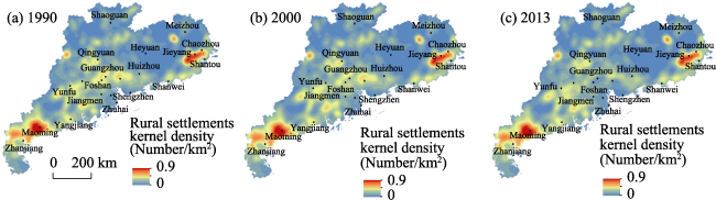
Figure 1 The spatial pattern of rural settlement kernel density in Guangdong Province from 1900 to 2013
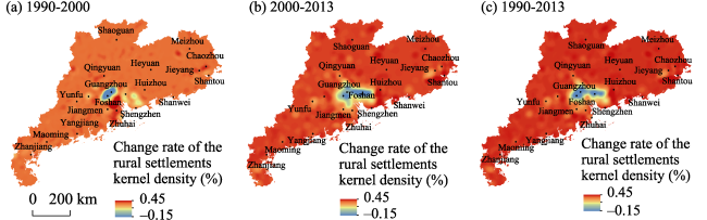
Figure 2 The change rate of the rural settlement kernel density in Guangdong Province from 1900 to 2013

3.2 Statistical analysis of rural settlement space distribution based on road traffic accessibility

Roads are the axes that form the connection between rural settlements and the main channel of material and information flows between settlements, as well as the foundation of rural association strength networks. Previous studies include the statistical analysis of the characteristics of the spatial distribution of rural settlements on the basis of the distance of adjacent traffic lines and the adjacent distance of neighboring towns. The spatial layout of rural settlements is affected by various locational conditions, and the accessibility of transportation integrating the influence of the adjacent distance of road traffic lines and the radiation effect of town centers forms the comprehensive measurement index of locational conditions. In this study, the different resistance values of road traffic are set according to different driving and walking speeds on the roads of different scale levels. In order to obtain the scales of the minimum cumulative accessible resistance value of each grid with a spatial resolution of 100 m × 100 m for prefecture-level cities, counties (districts), villages, and towns, the Cost Distance analysis tools of GIS are used (Figure 3). By integrating the consideration of the levels of roads and the traffic accessibility of hierarchical roads in towns, it is possible to better represent the location conditions of each grid. To do so, we divide the minimum cumulative resistance value of traffic accessibility of 100 m × 100 m grids for prefecture-level cities in Guangdong province into five zones as <200,000, 200,000-300,000, 300,000-400,000, 400,000-500,000, >500,000 and so on; divide the minimum cumulative resistance value of traffic accessibility to the counties (districts) into five zones as <100,000, 100,000-150,000, 150,000-200,000, 200,000-250,000, >250,000 and so on; and divide the minimum cumulative resistance value of traffic accessibility to villages and towns into five zones as <45,000, 45,000-90,000, 90,000-135,000, 135,000-180,000, >180,000 and so on. We separately carried on the statistics of the number and size of the spatial distribution of rural settlements within each zone (Table 1). The number of rural settlement patches in the area where the minimum cumulative resistance values to prefecture-level cities are under 400,000 is 353,919, accounting for 71.27% of the total number and 80.5% of the total area of rural settlements. The number of rural settlement patches in the area where the minimum cumulative resistance value to the countries is under 200,000 is 425,797, accounting for 85.72% of the total number and 90.36% of the total area of rural settlements. The number of rural settlement patches in the area where the minimum cumulative resistance values to the villages and towns are under 200,000 is 479,661, accounting for 96.32% of the total number and 96.86% of the total area. The low value directivity characteristics for the minimum cumulative resistance of road traffic accessibility of the spatial distribution of rural settlements in Guangdong are significant. The neighbor correlation between the spatial distribution of rural settlements and traffic accessibility to central towns at different levels varies, and the accessibility of the roads to villages and towns has the greatest influence on the spatial distribution of rural settlements. However, the influence on the spatial distribution of rural settlements of the accessibility of the roads to the level of prefecture-level cities is relatively smaller.
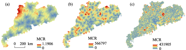
Figure 3 The spatial distribution of road traffic accessibility resistance values to prefecture-level cities (a), counties (b), and towns (c) in Guangdong Province in 2012
Table 1 Rural settlements in different zones of road traffic accessibility resistance values to prefecture-level cities, counties, and towns in Guangdong Province in 2013
Resistance value to prefecture-level cities(×104) Number Percentage (%) Area (ha) Percentage (%) Resistance value to counties (×104) Number Percentage (%) Area Percentage (%)
(ha)
<20 123183 24.81 282599.8 39.46 <10 153337 30.87 315588.46 44.06
20-30 124256 25.02 165219.2 23.07 10-15 162224 32.66 215535.62 30.09
30-40 106480 21.44 128698.7 17.97 15-20 110236 22.19 116102.82 16.21
40-50 80260 16.16 72256.98 10.09 20-25 56121 11.3 54703.57 7.64
>50 62419 12.57 67383.22 9.41 >25 14863 2.99 14355.27 2
Resistance value to towns (×104) Number Percentage (%) Area (ha) Percentage (%)
<4.5 236972 47.58 342533.842 47.62
4.5-9.0 183301 36.81 267395.335 37.18
9.0-13.5 59388 11.93 86747.7314 12.06
13.5-18.0 14326 2.88 17894.74635 2.49
>18.0 4013 0.81 4669.517706 0.65

3.3 Statistical analysis of the spatial distribution of rural settlements based on the physical geographical main control elements

Physical geographical factors are the basis for the formation and development of rural settlements, and terrain is the dominant factor that provides space for the formation and development of rural settlements, while restricting the spatial layout of rural settlements. Elevation and slope are the two important factors influencing the spatial pattern of rural settlements. The main influencing factors of rural settlements mainly include elevation, slope, average annual precipitation, average annual temperature, and distance to the main rivers (Figure 4). We divided the elevation of Guangdong into five altitudinal belts as <100 m, 100-300 m, 300-500 m, 500-700 m, >700 m and five slope scopes as <5º, 5º-10º, 10º-15º, 15º-25º, >25º, and carried out statistical survey of the scale of rural settlements within the scope of different altitudes and slopes (Table 2). The rural settlement patches in Guangdong are mainly distributed in areas where the altitude height is below 100 m. The total number of rural settlement patches is 279,634, accounting for 55.99% of the total number and 77.74% of the total area. Within the altitudinal range of 100-300 m, the number of rural settlements patches is 167,842, accounting for 33.61% of the total number and 17.99% of the total area of rural settlements. Compared to the first elevation belt, the number of rural settlement patches decreases gradually. The area of rural settlements located in the area with an altitude above 500 m accounts for less than 5% of the total area. The number of rural settlements distributed on slopes with a gradient range of 0º-10º is 340,260, accounting for 82.51% of the total area. The number of rural settlements distributed on slopes with a gradient of over 10º only accounts for 17.49% of the total area of rural settlements. The distribution of rural settlements in Guangdong province shows that rural settlements decline with the rise of elevation and gradient.
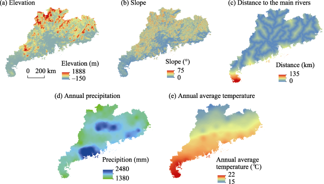
Figure 4 The spatial patterns of the major physical geographical factors in Guangdong Province
Table 2 Rural settlements in different zones of elevation and slope in Guangdong Province in 2013
Elevation (m) Number Percentage (%) Area (ha) Percentage (%) Slope (°) Number Percentage (%) Area (ha) Percentage (%)
<100 279634 55.99 562847.5 77.74 <5 194421 38.93 382235.6 52.82
100-300 167842 33.61 130262.92 17.99 5-10 145839 29.2 214827.7 29.69
300-500 38177 7.64 22833.94 3.15 10-15 75585 15.14 73520.49 10.16
500-700 11064 2.22 6315.56 0.87 15-25 65703 13.16 43263.33 5.98
>700 2707 0.54 1396.14 0.19 >25 17852 3.57 9801.06 1.35
The Lingnan area is rich in precipitation and its river networks are widespread. The functional characteristic of the agricultural production of rural settlements determines the features of the spatial distribution of rural settlements through which the river system has the characteristics of the Lingnan area flows. The characteristics of agricultural valley civilizations are obvious, and the hydrothermal condition is the basic physical geographical factor of agricultural production which is also an important index to evaluate the suitability of human settlement. Based on the ArcGIS software platform, the spatial analysis of distance distribution according to the vector data of the main rivers in Guangdong is calculated. The adjacent distance to the main rivers in the province can be divided into five adjacent zones as <10 km, 10-20 km, 20-30 km, 30-40 km, and >40 km. The multi-year average temperatures are divided into five scopes as <16°C, 16-17°C, 17-18°C, 18-19°C, and >19°C. Statistics are collected on the number and proportion of the spatial distribution of rural settlements (Table 3). The number of rural settlements that are distributed within the scope of less than 20 km away from the main rivers is 411,374, accounting for 82.58% of the total number, while the number of rural settlements that exceed the scope of 30 km is 14,072, only accounting for 2.82% of the total percentage. A large proportion of Guangdong belongs to a tropical climate where the average annual temperature is generally high and the spatial variation of temperature is mainly due to factors of latitude and vertical zonality. It can be seen from the statistical results that 75.41% of rural settlements are located in areas where the multi-year average temperature is above 18°C; these areas happen to be in the plain area of the Pearl River Delta. However, the regions where the multi-year average temperature is a bit lower are principally concentrated in the mountainous areas on the periphery of the Pearl River Delta. Multiple constraints such as terrain factors and the convenient levels of traffic, as well as the agricultural production resources, lead to the discrete spatial distribution and small scale of rural settlements, which is consistent with the results of terrain statistical analysis.
Table 3 Rural settlements in different zones of the distance from main rivers and temperature in Guangdong Province in 2013
Distance (km) Number Percentage (%) Area (ha) Percentage (%) Annual average temperature (°C) Number Percentage (%) Area (ha) Percentage (%)
<10 262033 52.60 386671.2 53.40489 <16 4637 0.93 3337.59 0.47
10-20 149341 29.98 179346.4 24.77033 16-17 49352 9.92 46745.21 6.51
20-30 72714 14.60 107934.2 14.90727 17-18 152311 30.62 126434.36 17.62
30-40 8093 1.62 20802.5 2.873127 18-19 175543 35.29 286322.48 39.90
>40 5979 1.20 24857.18 3.433137 >19 115614 23.24 254841.83 35.51

3.4 Quantitative identification of the multi-factors affecting the spatial distribution of rural settlements

The space distribution and dynamic changes of rural settlements are doubly affected by the original conditions of physical geographical elements and socio-economic development (Yang et al., 2015). We can gain further quantitative identification of the influencing factors and the influence degrees of the spatial distribution of rural settlements on the basis of the statistics of the characteristics of the spatial distribution of rural settlements. This is based on traffic accessibility and the grading and internal classification of typical physical geographical factors. Due to the restriction of data availability, this study mainly focuses on the physical geographical elements and traffic accessibility factors of the spatial distribution of rural settlements. Eight factors were selected as elevation (x1), gradient (x2), multi-year average precipitation (x3), the distance from the main rivers (x4), multi-year average temperature (x5), the minimum cumulative resistance value of the accessibility to prefecture-level cities (x6), the minimum cumulative resistance value of the accessibility to counties (districts) (x7), the minimum cumulative resistance value of the accessibility to villages and towns (x8), and so on. During the establishment of the regression model, the data normalization of the standard deviation of the eight factors was carried on respectively.
Due to the multilevel road traffic data at the end of 2012, in this study we selected the essential data established by the data model of the distribution of rural settlements in 2013 in Guangdong. We converted the vector data of rural settlement patches in 2013 in Guangdong to a 0 1 binary raster data layer with a spatial resolution of 100 m. By extracting the binary raster data and raster data of eight factors of rural settlements corresponding to the sampling point location by means of random sampling (the number of sampling points is 12000), the Logistic1( Logistic regression models can deal with the binary data regression primal. In this model, P is on behalf of the appearance probability of the spatial distribution of rural settlements.) regression model between the spatial distribution of rural settlements in Guangdong and the influencing factors was established as follows:
$\log \left( \frac{P}{1-P} \right)=-0.324{{x}_{1}}-0.273{{x}_{2}}-0.041{{x}_{3}}-0.038{{x}_{4}}-0.135{{x}_{8}}-1.108$ (3)
Since the regression coefficients of x5, x6, and x7 did not pass the significance testing of 0.05 in the process of model establishment, they were eliminated from the model. The test value of ROC is 0.82, as shown in the results of the Logistic regression. The spatial distribution of rural settlements in Guangdong has a spatial distribution directivity of low altitude, low slope, adjacent rivers, as well as to villages and towns. The formation and development, shape and size, and space layout of rural settlements are influenced by natural conditions, socio-economic conditions, historical developments, and habits and customs, so the pattern of the spatial distribution of rural settlements is a comprehensive outcome of multiple factors. The development and spatial layout of rural settlements has historical continuity. Natural conditions are the foundation of rural settlements and the climate and terrain conditions have a significant influence on the distribution of rural settlements. It can be seen from the regression results that the altitude, gradient, multi-year average precipitation, distance from the main rivers, and minimum cumulative resistance value of the accessibility to villages and towns all present a negative correlation with the distribution of rural settlements. The regression coefficients are 0.324, 0.273, 0.324, 0.038, and 0.135 respectively. Natural factors are the basis of the formation and development of the spatial structures of rural settlements. The Pearl River Delta plain, the Chaoshan plain of Hanjiang River Delta, and the hilly tableland region of Zhanjiang are areas generally suitable for rural settlements in the traditional agricultural production period due to the flat terrain, intertwined river networks, abundant cultivated land resources, convenient transportation, suitable production and living conditions. The distribution of rural settlements in such areas is quite dense, and the rural scale is relatively larger. Water is one of the basic conditions for the formation of settlements. The formation and development of rural settlements has a close and inseparable relationship with water resources. Surface and underground water resources have a direct impact on the form, evolution, and spatial distribution of rural settlements. The spatial distribution of settlements has obvious water source directivity. It is also doubly influenced by the spatial dispersion and accessibility of cultivated land resources. The characteristic of the spatial layout in the beaded style of rural settlements that lie near the river valleys and traffic lines in the peripheral mountainous areas of the Pearl River Delta region is obvious. The formation and development of rural settlements has a close relationship with socio-economic development. In the process of modernization, the construction of traffic infrastructure and the improvement of regional accessibility levels play a crucial role in the spatial extension of rural settlements and the land use changes of rural residential areas. The development of transportation promotes the spatial extension of rural settlements and changes the external form of villages, and is also the basic support power of the spatial extension of modern countries. The developmental level of traffic and the direction and levels of transport lines affect the pattern evolution of rural settlements. The improvement of means of transportation and the construction of traffic networks and infrastructure affects the transformation of the form, distribution, and the spatial pattern of the surrounding rural settlements. The location advantages such as modern and efficient traffic conditions and proximity to markets boost space expansion and increase the number of rural settlements.
The spatial evolution and development of rural settlements are comprehensively affected by multi-dimensional elements. The physical geographical element is the basic support driving force that establishes the fundamental historic pattern of the spatial distribution of rural settlements. It is also the basis of the formation and development of settlement environments, and the basic constitution of physical geographical factors. Factors such as topography, landforms, hydrothermal conditions, cultivated land resource endowment, and so on are the basic supports of the regional production and life functions of rural settlements and have a fundamental influence on the spatial dynamics and evolution of rural settlements. The spatial organization of extensive rural areas relies on the village and town systems, where villages and towns are central places within the region and support the functions of markets, science and education, culture and health, consumption, and public services. This exerts a significant influence on rural socio-economic development which in turn affects the spatial evolution and development of rural settlements. From the perspective of the central radiation of regional cities, villages, and towns, the central radiation of villages and towns has a significant influence on the spatial distribution of rural settlements. However, compared to the villages and towns, the radiation effect of central places with high levels, such as prefecture-level cities and counties (districts), on the spatial distribution of rural settlements is insignificant. The construction of the village and town systems and matching service facilities is the core of the stationing planning of villages and towns. Strengthening the traffic accessibility of rural settlements to villages and towns is the foundation of the construction of village and town systems, and also an important link in guiding the spatial reconstruction integration of rural settlements.

4 Discussion on the research content framework of the evolution mechanism of rural settlements

Rapid urbanization and industrialization has brought about the swift transformation of urban and rural regional systems. The scale and speed of the exchange flow of production factors between rural and urban areas has increased, production factors and intellectual resources in rural areas precede that of non-agricultural transformation, and rural regional spaces are facing transformational development. Rural material, social, cultural, and ecological spaces are undergoing a process of transformation and reconstruction. The spatial distribution and influencing factors of rural settlement systems under the traditional and modern artistic conception has drawn wide attention in educational circles, with scholars mostly focusing on revealing spatial distribution patterns and the spatial directivity characteristics of geographical elements of rural settlements, etc. However, against the macro background of globalization, information, and urbanization, the spatial evolution and layout optimization of rural settlements is affected by multiple internal and external factors, especially since globalization and information have significant effects on the reconstruction of rural spaces, and multiple driving forces promote the diversified changes of rural regional spaces. Based on this, we attempt to discuss the future research content framework of the spatial distribution, evolution, and reconstruction mechanisms of rural settlements against the background of the diversified differentiation of rural regional space (Figure 5). At present, a large number of empirical case studies have demonstrated that the distribution of rural settlements has a regular pattern of space directivity. On this basis, we focus on the evolution analysis of the spatial structure of rural settlements and the landscape of the type of settlements that deepen the spatial process and the evolution of the form and pattern of rural settlements, and explore the mechanism and path of the reconstruction of material space and the resource optimization allocation of rural settlements. In the new period, rapid urbanization leads to the massive outflow of the rural labor force which aggravates the occurrence of the collapse or “hollowing out” of rural material spaces and rural societies, leading to the idle waste of resources and the decline of the landscape of rural settlements. The socio-cultural spaces in rural areas transform quietly, a transformation that is embodied in series of changes such as neighborhood relations, social networks, clan kinship, and the differentiation of residential space and social capitalization. Theoretical research on rural social space reconstruction is insufficient; this study will be an important element of future rural geography studies and will enrich and promote the study of the socio-cultural shift in Chinese rural geography. In research on landscape transformation in rural areas, the study of the type of rural settlements, land-use structures, architectural styles, the miscellaneous property of settlements, and the evolution and restrictions of the eco-environment is in need of a multidisciplinary, comprehensive integration and intersection study based on rural geography, architecture, ecology, and so on, which is vital to the enrichment of the research content of rural geography.
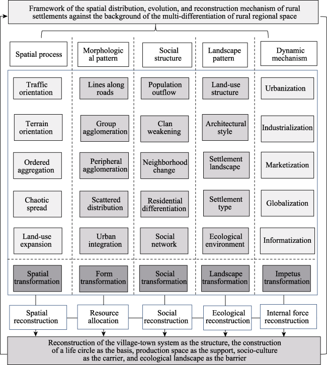
Figure 5 The research framework of rural settlements’ spatial distribution, evolution, and reconstruction against the background of rural spatial diversity transformation in China
Current studies on the spatial dynamics of rural settlements are relatively common, and the rural geographical research on the aspects of the micro landscape forms of rural settlements and the spatial construction of traditional settlements, as well as rural social networks, social individual behavior, group behavior, social autonomy, and the reconstruction of socio-cultural spaces have the potential for significant academic theoretical contributions. This paper applies the quantitative identification of the spatial distribution of rural settlements and its main controlling factors. This content framework for future research is summed up in order to further deepen research with different scales of “micro-meso-macro” on the reconstruction of rural multi-dimensional space in the Pearl River Delta and its peripheral areas, as well as to reveal the characteristics, processes, patterns, and mechanisms of the reconstruction and transformation of rural spaces in different regions. Docking in rural planning practice, generally the logic of rural stationing planning is the construction of a central place and the improvement of a network system. The study found that the radiation effect of villages and towns to the spatial pattern and the development of countries is significant, which shows that the construction of a life service circle in which villages and towns act as the core is particularly important to the spatial optimization allocation of rural land resources, the strengthening of the protection of socio-cultural space traditions, and the reconstruction of production, living, and ecological spaces in rural areas. In the era of Internet+, the rural production and consumption market network has been reconstructed. The topics such as the theory and mode of the participation of Chinese rural development in globalization will be the focus of the field, whose research on rural reconstruction in China will be deepened. Affected by the global economic crisis and the transformation of domestic industries, the partial migrant labor force in rural areas presents a weak trend of reflux. The return of the labor force will greatly influence rural settlement spaces and the socio-economic development and reconstruction. This new phenomenon will also be one of the research fields on which the study of rural geography will focus emphatically. In addition, cities in metropolitan areas have been continually expanding. The urban disease appears gradually, in the periphery of metropolitan areas, and is likely to generate a counter urbanization process. The interface docking of urbanization and rurality and the exclusion and integration of the construction of social networks will be important fields in need of further research. We will continue to focus on and subsequently conduct a related series of research in the future.

5 Conclusions

(1) In terms of the density distribution, the spatial difference of rural settlements in Guangdong province is generally significant; the spatial distribution of rural settlements in Guangdong has a significant spatial distribution directivity of low altitude, low slope, adjacent to rivers, as well as to villages and towns. The overall spatial distribution pattern is “Dense in plains, while sparse in mountainous areas.” The present distribution of density cores of rural settlements is relatively decentralized, mainly forming two density cores in the form of the Chaoshan plain to the east and the Zhanjiang plain platform to the west of Guangdong. These are both suitable areas for widely distributing rural settlements in the traditional agricultural production period due to the flat terrain, intertwined river networks, and abundant cultivated land resources. The characteristics of the spatial layout in the beaded style of rural settlements that are near the river valleys and traffic lines in the mountainous areas on the periphery of the Pearl River Delta region is obvious. It is also influenced doubly by the spatial dispersion of cultivated land resources and accessibility.
(2) Elevation and slope are the two important topographic factors influencing the spatial pattern of rural settlements and have a significant influence on the scale, form, and distribution of rural settlements. The rural settlement patches in Guangdong are mainly distributed in areas where the altitude heights are below 100 m, accounting for 55.99% of the total number and 77.74% of the total area. Within the altitudinal range of 100-300 m, the number of rural settlement patches account for 33.61% of the total number and 17.99% of the total area. Rural settlements located in areas with an altitude above 500 m account for less than 5% of the total. The number of rural settlements distributed on the slope with a gradient range of 0º-10º is 340,260, accounting for 82.51% of the total area.
(3) The value of the minimum cumulative resistance of traffic accessibility of multilevel roads to central-place cities (towns) has a significant influence on rural settlements’ spaces, showing a significant negative correlation. Traffic accessibility of multilevel roads to villages and towns has the greatest influence on the spatial distribution of rural settlements. The central radiation effect of villages and towns plays an important role in the construction of village and town systems. The effect of traffic accessibility of multilevel roads to the counties (districts) on rural settlements is not particularly evident. As natural waterways, rivers have an important influence on the development and growth of traditional villages. Temperature and precipitation exert some influence on the spatial distribution of rural settlements, the heterogeneity of elements is comparatively small in the tropical regions, and its effects are associated with the influence of physical geographical factors such as terrain on the spatial distribution and evolution of rural settlements.
(4) Docking in the time-background of urbanization, information, and globalization, research on rural geography should focus on the core problems such as the micro landscape forms of rural settlements and the spatial construction of traditional settlements, as well as the rural social network, social individual behavior, group behavior, social autonomy, and the constant reconstruction of socio-cultural space. In the era of Internet+, core topics such as the reconstruction mechanism of rural production and consumption market networks as well as integration into globalization will be key fields in need of further research. In the discipline of the construction of urban-rural planning and rural planning practice, constructing life and service circles in rural areas in which villages and towns act as the core, reconstructing and optimizing the village and town systems, perfecting the diversification of production in villages and towns and the functions of consumption and public services, as well as the theory and practice of planning, construction, and production, life, ecological, historical, and cultural spaces will be momentous research fields and directions that urgently demand that we deepen our understanding of urban-rural planning.

The authors have declared that no competing interests exist.

[1]
Arthur G, Judith G, 1966. Christaller’s Central Place Theory.Journal of Geography, 65(5): 220-226.

DOI

[2]
Chen C, Gao J L, Chen J L, 2017. Institutional changes, land use dynamics, and the transition of rural settlements in suburban China: A case study of Huishan District in Wuxi city.Habitat International, 70: 24-33.

DOI

[3]
Fan S Y, 1994. The evolution mechanism & study contents on the spatial structure about rural settlement.Journal of Northwest University (Natural Science Edition), 24(4): 295-304. (in Chinese)

[4]
Guo X D, Ma L B, Zhang Q Y, 2013. The spatial distribution characteristics and the basic types of rural settlement in loess hilly area: Taking Qin’an County of Gansu Province as a case. Scientia Geographica Sinica, 33(1): 45-51. (in Chinese)

[5]
Hai B B, Li X J, Xu J W, 2013. Spatio-temporal evolution of rural settlements in Gongyi.Geographical Research, 32(12): 2257-2269. (in Chinese)Gongyi is the top county of Henan Province in economic development. By using GIS technology,landscape indices and spatial statistical methods,this paper aims to analyze the evolution of the rural settlements,and their spatial distribution and rank-size distribution of landscape patterns from 1990 to 2010,and to investigate the influence of landform,location,social and economic factors on the development of rural settlements in Gongyi. The landscape indexes used in this paper consist of total area(TA),percentage of landscape(PLAD),number of patches(NP),patch density(PD),largest patch index(LPI),mean patch size(MPS),patch size standard deviation(PSSD),mean shape index(SHAPE_MN),mean fractal dimension index(FRAC_MN) and aggregation index(AI). With these indexes,this paper characterizes the scale and shape of rural settlement patches. Kernel density estimation method is used to show the density distribution of rural settlements. Then,some spatial methods,e.g. average nearest neighbor,Getis-ord General G and Getis-Ord Gi* are used to explore the distribution pattern and size distribution of rural settlements. The effect factors behind rural settlement changes are divided into three types: geomorphology factors,location factors and socio-economic factors,and then we discuss the influences on the spatial pattern evolution of rural settlements. The main findings of this study are drawn as follows.(1) The size of rural settlements in Gongyi expanded significantly and the level of intensive land use was low.(2) The shape of rural settlement patches appeared to be regular,implying that the effect of planning and management was emerging.(3) In spatial distribution,the rural settlement patches were characterized by agglomeration. There was a general negative correlation between the density distribution and the size distribution,indicating that there was a high density distribution of small rural settlements and vice versa.(4) There was little change in the entire spatial pattern of rural settlements in Gongyi during 1990-2010,but a concentration in local areas was observed. This is true not only for plain and hilly areas,but also for the regions with rapid economic development.(5) These spatial patterns were affected by physical conditions,but in a micro-level spatio-temporal context,location factors and socio-economic factors played an even bigger role. The results of this study may provide policy guidance for restructuring spatial patterns of rural settlements.

DOI

[6]
Hamerow H, 2012. Rural Settlements and Society in Anglo-Saxon England. London: Oxford University Press.

[7]
He R W, Chen G J, Liu S Qet al., 2012. Research progress and tendency of Chinese rural settlements geography.Progress in Geography, 31(8): 1055-1062. (in Chinese)In recent years,with the continued advancement of Chinese new countryside construction,rural development has attracted increasing academic attention.Rural settlement geography,as an important branch of settlement geography,has been attached importance again.Understanding the research progress of rural settlement geography and examining its trends can not only promote the academic development of human geography,but also promote the coordinated development of urban and rural areas and the construction of a new socialist countryside.Based on consulting extensive related literature,this paper firstly briefly describes foreign research progress of rural settlements geography,and believes that the relevant foreign research is very worth learning.Then,the research progress of Chinese rural settlements is sketched out.Subsequently,this paper summarizes and elaborates the recent research in the following four aspects:(1) research on rural settlement ecology,(2) research on spatial characteristics and evolution of rural settlements,(3) research on problems of rural settlements development,and(4) comprehensive research.Finally,on the basis of analyzing domestic and overseas research progress of rural settlements mentioned above,this paper argues that the main trends of Chinese future research on rural settlement geography should be listed as follows:(1) research on the evolutional trend prediction of rural settlements in the process of Chinese industrialization and urbanization,(2) research on the modes of Chinese rural settlements in regions at different development levels,(3) research on Chinese rural settlements in regions with different landforms;(4) research on the reconstruction of new settlements,and(5) research on the interdisciplinary and comprehensive field of rural settlements.

DOI

[8]
Huang X Y, Cao X S, Li T, 2011. The relationship between regional transport superiority and regional economic performance in Hainan.Geographical Research, 30(6): 985-999. (in Chinese)This study takes Hainan as a case and its 18 counties as basic unit for analysis.Choosing 3 indexes,including transport network density,proximity and accessibility,this paper constituted the spatial mathematical model to evaluate transport superiority degree firstly.Then,by utilizing GIS and IDW(Inverse Distance Weighted) technology,this paper studied spatial characteristic of transport network in Hainan.Moreover,we selected 4 aspects,i.e.,total economic output and industrial structure,population and urbanization,living standards,transportation and the urban construction,20 indexes all together and uses SPSS16.0 software with principal component analysis to quantitatively evaluate the level of economic development.By analysing spatial characteristic and summarizing spatial disciplinarian,this paper studied the relationship between regional transport superiority and economic performance in Hainan.The results showed that there were great differences in spatial distribution patterns between accessibility and economic development.But the spatial distribution patterns of transport superiority and regional economic performance are coherent,and there are positive relations between them,which showed an opposite spatial arrangement with geographic characteristics in Hainan.

DOI

[9]
Janečková Molnárová K, Skřivanová Z, Kalivoda Oet al., 2017. Rural identity and landscape aesthetics in exurbia: Some issues to resolve from a Central European perspective.Moravian Geographical Reports, 25(1): 2-12.

DOI

[10]
Knappen J P, Scheffer M, Harms B, 1992. Estimating habitat isolation in landscape planning.Landscape and Urban Planning, 23(1): 1-16.Habitat patches situated amidst an otherwise inhospitable landscape are often considered as islands in the sense of the equilibrium theory of insular zoogeography. Their species richness can be affected by isolation from other areas of suitable habitat. However, the isolation of habitat islands is not only dependent on the distance from the source area, as with oceanic islands, but also on the characteristics of the interjacent landscape. To account for the latter, the use of a measure of isolation termed ‘minimal cumulative resistance’ (MCR) is proposed. A simple model is described for calculating MCR from a grid-based map on which estimated dispersal resistances are assigned to landscape types. Application of the model is illustrated with a specific case: the allocation of new forests in the western part of the Netherlands. Although its application is bound by a number of restrictions, it is concluded that the model can be a useful aid in physical planning and nature conservation.

DOI

[11]
Li H B, Zhang X L, 2012. A review and trend on rural settlement geography abroad.Human Geography, 27(4): 103-108. (in Chinese)Rural settlements are places of habitation,production and the living for rural people,which are effected profoundly by the nature condition and factors of rural society,economy and culture.Rural settlement geography,as a main subject of rural geography,focuses on its structure type,distribution characteristic,evolution,the environment(natural and social) relations as well as transformation and reconstruction.Nowadays,rural settlement geography research is a hot spot,especially in recent years.The abroad research on rural settlement geography is more comprehensive.This paper,based on plentiful literature,analyses the research contents of rural settlement geography abroad.And divides the research history into four stages: embryonic stage,initial development stage,expansion and change stage,transition and reconstruction stage.Then we conclude rural settlement geography research content system abroad as follows:(1) the impact of factors of rural settlements layout;(2) the types and patterns of rural settlements;(3) the research of rural settlement land use;(4) the landscape study of rural settlements;and(5) ecological research of rural settlements.On the bases of these summarizations,we describe the research and development trends of the subject recently to provide theoretical and practical reference guides for domestic researchers.We argue that rural settlement geography abroad is paying more attention to studying on the socialization and the reconstruction of rural settlements.As we all know,the area of our country's rural region is broad with the numerous population and huge rural settlements.The domestic rural settlement geography research still needs to be strengthened.While the rural settlement of China has changed a lot with the development of society and economy,rural settlement geography research should be paid more attention.We could take the spatial transformation of rural settlements as a breakthrough point,combine with the particularity of China's current rural development,and study the rural settlement spatial reconstruction of the characteristics,the dynamic mechanism,typical patterns.This will be not only helping to build a more reasonable rural settlement spatial transformation theory system,enrich rural geography research,but also reveal the conflicts and problems in rural development.It will be provide a basis for government in formulating rural development strategies and policies to improve the spatial decision-making.

[12]
Li Q L, Ma X D, Shen Yi, 2012. Analysis of spatial pattern of rural settlement in northern Jiangsu.Geographical Research, 31(1): 144-154. (in Chinese)Based on the satellite image of northern Jiangsu in 2008,by using spatial metric models such as spatial interpolation,spatial correlation index,and semivarigram,the paper analyzed the spatial pattern characteristics of rural settlements in the northern Jiangsu region.Some conclusions are drawn as follows.(1) The number of rural settlements distributed in the southern part is larger than that of the northern part in the northern Jiangsu region in terms of spatial distribution,espacially they are distributed most densely in central and southern parts of the region,then exhibits a stepwise decrease.(2) Scale distribution of rural settlements shows a strong spatial autocorrelation,and similar areas are respectively characterized by aggregation distributions in space.The high-value clusters of rural settlement scale are distributed mainly in Xuzhou,Lianyungang,and Suqian.The scale of rural settlement distributed in the north is much larger than that of the south in northern Jiangsu in spatial distribution.(3) The shape distribution of rural settlements shows good continuity and stability,the random of the spatial differential pattern is much lower than the mechanism of the structural differentiation caused by natural correlation in space.Spatial difference of rural settlement distribution is much larger,but it shows some concentration.In terms of different orientations,spatial difference of rural settlement distribution is much larger in the southeast-northwest,rural settlement distribution enveloped from ribbon,long rectangle,and rectangle to sugariness or irregular conglomeration.Above all,the formation and development of rural settlements in northern Jiangsu always has strong correlation with natural conditions such as terrain and river,which is less sensitive to social economy,so the distribution of rural settlements in northern Jiangsu shows obvious spatial dependence.

DOI

[13]
Liu X F, Shu J M, Zhang L B, 2010. Research on applying minimal cumulative resistance model in urban land ecological suitability assessment: As an example of Xiamen City.Acta Ecologica Sinica, 30(2): 421-428. (in Chinese)Assumed two processes of town land and ecological protected land expanding to simulate urban landscape dynamic,this paper established an ecological suitability assessment method based on minimum cumulative resistance margin,which can be expressed by using the formula of MCRmargin=MCRecological protected land expansion-MCRurban land expansion.When one pixel's MCRmargin0,it should be divided into eco-appropriate land;Instead,when MCRmargin0,it should be classified as the land suitable for construction;and when MCR margin = 0,it should be regard as the watershed between eco-appropriate and construction suitable land.As an example of Xiamen,this paper selected the existing town land and eco-protected land as the sources of expanding,and established a system to calculate resistance from six aspects:terrain,land use,hydrogeology,ecological value,ecological sensitivity,and ecological function.Based on the mentioned method,this paper divided Xiamen into four developmental zones:prohibited,restricted,key and optimized areas,which were 525.3 km2,455.0km2,340.8km2,243.9km2,respectively.The land suitable for eco-protection was 980.3 km2,while suitable for construction was 584.7 km2.

DOI

[14]
Liu Y S, Yang Y Y, Li Y R, et al., 2017. Conversion from rural settlements and arable land under rapid urbanization in Beijing during 1985-2010.Journal of Rural Studies, 51: 141-150.61Spatiotemporal characteristics of rural settlements loss and arable land depletion during urbanization was explored.61Different degrees of rural non-agriculturalization were zoned.61Spatial modes of rural non-agriculturalization along the urban-rural gradient and the motorways were proposed.

DOI

[15]
Long H L, 2013. Land consolidation and rural spatial restructuring.Acta Geographica Sinica, 68(8): 1019-1028. (in Chinese)

[16]
Long H L, Liu Y S, Wu X Qet al., 2009. Spatio-temporal dynamic patterns of farmland and rural settlements in Su-Xi-Chang region: Implications for building a new countryside in coastal China.Land Use Policy, 26(2): 322-333.This paper analyzes the spatio-temporal dynamic patterns of farmland and rural settlements from 1990 to 2006 in Su–Xi–Chang region of coastal China experienced dramatic economic and spatial restructuring, using high-resolution Landsat TM (Thematic Mapper) data in 1990, 1995, 2000 and 2006, and socio-economic data from both research institutes and government departments. To examine the spatial patterns of farmland and rural settlements and their change over time, a set of pattern metrics that capture different dimensions of land fragmentation was identified. The outcomes indicated that, to a large extent, land-use change from 1990 to 2006 in Su–Xi–Chang region was characterized by a serious replacement of farmland with urban and rural settlements, construction land, and artificial ponds. Population growth, rapid industrialization and urbanization are the major driving forces of farmland change, and China's economic reforms played an important role in the transformation of rural settlements. China's “building a new countryside” is an epoch-making countryside planning policy. The focuses of building a new countryside in coastal China need to be concentrated on protecting the farmland, developing modern agriculture, and building “clean and tidy villages.” Rural construction land consolidation and cultivated land consolidation are two important ways to achieve the building objectives. The authors argue that it is fundamental to lay out a scientific urban–rural integrated development planning for building a new countryside, which needs to pay more attention to making the rural have certain functions serving for the urban. In addition, the cultural elements of idyll and the rural landscape need to be reserved and respected in the process of building a new countryside in coastal China, instead of building a new countryside, which looks more like a city.

DOI

[17]
Ma L B, Guo X D, Zhang Q Y, 2012. Spatio-temporal distribution and optimization of rural settlements in Gangu county of loess hilly area.Transactions of the Chinese Society of Agricultural Engineering, 28(13): 217-225. (in Chinese)In order to provide preliminary reference for the optimized of rural settlements area and intensive use of land the spatio-temporal distribution of rural settlements in Loess Hilly Area,Gangu county was analyzed,.Based on the remote sensing images of Landsat-5 TM in 1998 and SPOT 5 in 2008,the method of landscape pattern analysis and GIS spatial analysis were used to discussed spatio-temporal variability and optimized spatial distribution of rural settlements in Gangu county from 1998 to 2008.The results showed that from the perspective of temporal distribution,the proportion of the area of rural settlements in the total land area increased from 3.69% to 5.45% in the last decade;patches number(NP) and total plaque area(CA) increased by 114.77% and 47.76% respectively.The settlement patches have a high density of 1.68 per km2 at present;The patches were quite different over the two periods and the average plaque area(MPS) decreased.From the perspective of spatial distribution,the density of rural settlements in 2008 was significantly higher than that in 1998,the distribution pattern of rural settlements vary spatially as dense in the northeast and areas around county,while sparse in the southwest.Rural settlements showed a strong association with the elevation,slope,traffic and water resources,and they mainly located in areas with low altitude,gentle slope and closed to road or river.For the coordinated social and economic development of urban and rural areas and the successful realization of well-off society,it is necessary to optimize spatial distribution of rural settlements in Gangu county with three development patterns of the priority development,extension development and centralized development.

DOI

[18]
Ma X D, Li Q L, Shen Y, 2012. Morphological difference and regional types of rural settlements in Jiangsu Province.Acta Geographica Sinica, 67(4): 516-525. (in Chinese)

[19]
Peng Y, 2015. A comparison of two approaches to develop concentrated rural settlements after the 5.12 Sichuan Earthquake in China. Habitat International, 49: 230-242.61Compares two approaches to develop concentrated rural settlements (CRS) in post-disaster reconstruction in China.61Compare according to socio-natural basis, trigger event, participants, principles, revenue allocation, process and implementation outcome.61Develop a roadmap of delivering CRS in post-disaster reconstruction.61Facilitate local governmentsto develop CRS in post-disaster reconstruction.

DOI

[20]
Quinn B, Wilks L, 2017. Festival heterotopias: Spatial and temporal transformations in two small-scale settlements. Journal of Rural Studies, 53: 35-44.

DOI

[21]
Ren P, Hong B T, Liu Yet al., 2014. A study of spatial evolution characteristics of rural settlements and influences of landscape patterns on their distribution using GIS and RS. Acta Ecologica Sinica, 34(12): 3331-3340. (in Chinese)Forms of human habitation within rural settlements are a major component of rural landscapes. The spatial patterns and evolutionary characteristics of rural settlements are influenced by multiple factors,including natural,social,and economic elements. It is,therefore,important not only to properly identify and assess the spatial distribution patterns and evolutionary modes of rural settlements,but also to uncover causative laws and influential factors behind their evolution. This can facilitate scientific rural planning and enhance optimal distribution of urban and rural land resources.Our study is based on a series of digitalized vector data,including the locations of rural settlements,land slopes,rivers,and road networks obtained from remote sensing( RS) images of the city of Dujiangyan in Sichuan Province for 2005 and2010. We applied analytical techniques derived from Geographic Information Systems( GIS) and RS to quantitatively analyze the processes,patterns,and trends of spatial evolution in rural settlements. Specifically,we explored landscape pattern indexes to examine in depth the factors influencing the distribution characteristics of rural settlements in the studyarea. Our results showed that: 1) In general,while there was significant clustering in the spatial distribution of rural settlements in Dujiangyan during both 2005 and 2010,this settlement pattern was even more significant in 2010. Along with an increase in the spatial scale,the degree of the clustering tendency also increased,reaching a maximum value at a scale of 13 km. 2) The presence of land slopes,roads,and rivers significantly influenced the distribution of rural settlements in Dujiangyan as evidenced by the following findings. More than 80% of settlements were located in areas with slopes of less than 10 degrees; over 50% of settlements were located within 500 m from a road network; and almost 60% were distributed within 1000 m of a river. 3) In 2005 as well as 2010,there was no obvious change in the concentrated locations of clusters,which were consistently found in the southeastern region of Dujiangyan City. However,during both time periods,fewer settlements were found in the townships of Hongkou,Longchi,and Qingcheng Mountain. The reason for this imbalance in the spatial distribution of rural settlements was that besides the influence by natural factors such as the landscape,the distribution patterns of rural settlements in Dujiangyan were also closely associated with several planning elements. These included a policy of protecting national regions of scenic interest and a World Cultural Heritage site located in the city,the rural land comprehensive consolidation projects and post-earthquake reconstruction planning. 4) Based on the above findings on factors that influence the distribution of rural settlements,our research suggests that comprehensive consideration of topographical and geological conditions is required for optimal adjustment of rural settlement patterns.Scientific planning procedures can promote the relocation of rural residents from villages to townships and urban areas,and help to lessen disruption in environmentally protected regions. They can also reinforce the effective use of land resources and increase land supporting capabilities. We expect our research to provide a methodological reference for similar research conducted in the future. It can also provide a theoretical and practical reference for rural land-related decision-making and technical support,for example,dynamic monitoring of changes in rural settlements,assessments of rural land consolidation,and the"New Socialist Countryside"rural planning policy.

DOI

[22]
Schwarz K, 2015. Censer fragmentation and life history: Rural domestic settlement enchainment and accumulation activities and the Classic-Postclassic transition of the Petén Lakes region, Guatemala.Geophysical Research Letters, 33(1): 89-90.1] A suite of climate model experiments indicates that 20th Century increases in ocean heat content and sea-level (via thermal expansion) were substantially reduced by the 1883 eruption of Krakatoa. The volcanically-induced cooling of the ocean surface is subducted into deeper ocean layers, where it persists for decades. Temporary reductions in ocean heat content associated with the comparable eruptions of El Chich n (1982) and Pinatubo (1991) were much shorter lived because they occurred relative to a non-stationary background of large, anthropogenically-forced ocean warming. Our results suggest that inclusion of the effects of Krakatoa (and perhaps even earlier eruptions) is important for reliable simulation of 20th century ocean heat uptake and thermal expansion. Inter-model differences in the oceanic thermal response to Krakatoa are large and arise from differences in external forcing, model physics, and experimental design. Systematic experimentation is required to quantify the relative importance of these factors. The next generation of historical forcing experiments may require more careful treatment of pre-industrial volcanic aerosol loadings.

DOI

[23]
Tang C L, He Y H, Zhou G Het al., 2014. The research on optimization mode of spatial organization of rural settlements oriented by life quality.Acta Geographica Sinica, 69(10): 1459-1472. (in Chinese)

[24]
Tian G J, Qiao Z, Gao X L, 2014. Rural settlement land dynamic modes and policy implications in Beijing metropolitan region, China. Habitat International, 44: 237-246.61This paper analyzes the dynamics of spatio-temporal patterns of rural settlements in Beijing.61Three dynamic modes were distinguished and used to study rural development.61Edge-expansion dominated during the rapid expansion of rural development.61This paper studies drivers of the distance to cropland, water bodies, roads and urban centers.

DOI

[25]
Tian Y, Kong X, Liu Yet al., 2016. Restructuring rural settlements based on an analysis of inter-village social connections: A case in Hubei Province, Central China.Habitat International, 57: 121-131.61This paper advances our understanding of the relationship between social connections and rural settlement reconstruction.61The features of inter-village social connection network were analyzed spatially and non-spatially.61Social connection analysis contributes to the identification and planning of village-town systems.61Three restructuring directions were distinguished based on the analysis of social connection strength and ideal radius.

DOI

[26]
Trukhachev A, 2015. Methodology for evaluating the rural tourism potentials: A tool to ensure sustainable development of rural settlements.Sustainability, 7(3): 3052-3070.The paper analyses potentials, challenges and problems of the rural tourism from the point of view of its impact on sustainable rural development. It explores alternative sources of income for rural people by means of tourism and investigates effects of the rural tourism on agricultural production in local rural communities. The aim is to identify the existing and potential tourist attractions within the rural areas in Southern Russia and to provide solutions to be introduced in particular rural settlements in order to make them attractive for tourists. The paper includes the elaboration and testing of a methodology for evaluating the rural tourism potentials using the case of rural settlements of Stavropol Krai, Russia. The paper concludes with a ranking of the selected rural settlements according to their rural tourist capacity and substantiation of the tourism models to be implemented to ensure a sustainable development of the considered rural areas.

DOI

[27]
Wang C, Fei Z H, Ye Q Let al., 2014. Rural settlement space reconstruction strategy and implementation based on symbiosis theory on village scale.Transactions of the Chinese Society of Agricultural Engineering, 30(3): 205-214. (in Chinese)Rural residential areas are an extensive dispersion with localized concentrations, and the area of land utilization per capita is large in Dazhu village in Hechuan of Chongqing. Inefficient utilization of rural residential areas is an adverse process all over China during the urban-rural transitional period, especially in traditional agricultural areas. The space reconstruction of a rural residential area could be a breakthrough in the rational utilization of land resources, advancing new countryside construction, restructuring village space, and promoting urban-rural integration and development. This paper used the symbiotic theory to establish a rural residential restructuring symbiotic system. The system included rural residential areas as a symbiotic unit, and the policy environment and the village-domain environment as symbiotic environment. Due to the mutual functional differences of symbiotic units, village spatial reconstruction should consider a mutually beneficial symbiotic relationship between the units, namely the mutualism mode. The research analyzed a rural residential restructuring symbiotic system, and made clear the restructuring principles and procedure needed to build the space reconstruction strategy of a rural settlement. The thesis selected the demonstration village of the whole village advancement azhu village in Hechuan of Chongqing as the object of empirical study. It built three kinds of functional groups roductivity-oriented, service-oriented, and living-oriented groups, a space representation of which was already presented in the village, and formed the layout of ne axis and three groups' at the the village scale. The results showed that: first, adopting the rural residential restructuring symbiotic system analysis accords with the reality of Dazhu village to restructure village space. It further showed that the symbiotic theory has strong applicability to space reconstruction of a rural settlement. Secondly, the results of the empirical study showed that the space reconstruction of a rural settlement, which is based on the symbiotic strategy, can both ensure the inter-operability of a rural settlement and respect the principal position of farmers. It realizes hared resources, co-constructed environment' and exploits environmental advantages in the village domain. It can also improve the utilization efficiency of rural residential areas. Through the study of the demonstration village, the paper provides a scientific basis for formulating village space reconstruction and a new approach to the whole village advancement in a hilly area and the beautiful village construction. Due to the fact that the factors which influence rural residential restructuring are very complex, the regional social, economic, and environmental development strategies and resource endowment conditions which are expected to be considered comprehensively, need to be studied further. Different types of household willingness and future livelihoods also require deeper study.

DOI

[28]
Woods M, 2007. Engaging the global countryside: Globalization, hybridity and the reconstitution of rural place. Progress in Human Geography, 31(4): 485-507.

DOI

[29]
Xi J, Wang X, Kong Qet al., 2015. Spatial morphology evolution of rural settlements induced by tourism.Journal of Geographical Sciences, 25(4): 497-511.Rural tourism has become an important driving force of rural urbanization in China. As the main reception base and important tourism attraction, tourism village is the core element of the tourism...

DOI

[30]
Yang R, Liu Y S, Long H Let al., 2015a. Spatio-temporal characteristics of rural settlements and land use in the Bohai Rim of China.Journal of Geographical Sciences, 25(5): 559-572.中国科学院机构知识库(CAS IR GRID)以发展机构知识能力和知识管理能力为目标,快速实现对本机构知识资产的收集、长期保存、合理传播利用,积极建设对知识内容进行捕获、转化、传播、利用和审计的能力,逐步建设包括知识内容分析、关系分析和能力审计在内的知识服务能力,开展综合知识管理。

DOI

[31]
Yang R, Liu Y S, Long H Let al., 2015b. Research progress and prospect of rural transformation and reconstruction in China: paradigms and main content.Progress in Geography, 34(8): 1019-1030. (in Chinese)

DOI

[32]
Yang R, Liu Y S, Long H Let al., 2015c. Spatial-temporal characteristics of rural residential land use change and spatial directivity identification based on grid in the Bohai Rim in China. Geographical Research, 34(6): 1077-1087. (in Chinese)The article focuses on the scientific issues of rural settlements and its land use change during rural- urban transformation process. Based on the land use classification data from the remote sensing images and economic- social statistics data, using a 5 km 5 km grid for the minimum statistical scale and GIS spatial statistical analysis function, the temporalspatial change of the rural settlement and land use were comprehensively examined in the Bohai Rim in China. Main results for this study are as follows:(1) the spatial differentiation of rural settlements was significant in the Bohai Rim in China. The regions with more than five natural villages in a 5 km 5 km grid were located in agricultural and mountainous areas,especially in southern Hebei province and southwestern Shandong province, with "6" glyph spatial pattern, gradually increasing from northeast to southwest in the Bohai Rim in China,where the rural settlements were scattered, and rural settlement land was used extensively. The density of rural settlements and scattered degree are much higher in the traditional agricultural regions. Besides, the spatial differences of rural residential land and dynamic change were significant in the Bohai Rim in China. In terms of scale, the areas of rural residential land were larger in the plain area with a higher density of rural settlements, especially in the Huang-HuaiHai Plain and southern Shandong Peninsula, and most of the rural residential lands area scale was more than 3 sq km in the 5 km 5 km grid. In the traditional agricultural areas, economic development, industrialization and business- service development have lagged behind, with industrial development in an initial stage, so that a low urbanization rate has been found. The livelihood of most farmers is dual status between urban and rural areas.(3) On time series, the rural residential land areas increased in the traditional agricultural region. At the same time,rural residential lands have been changed to urban land use types in the rural and semi- urban areas in the provincial capital cities and prefecture-level cities, so the rural residential land use area decreased.(4) The influencing factors of driving rural settlements and landform and structure change refer to many aspects, including natural environmental conditions, location conditions, level of economic development and farmers' income.

[33]
Yang R, 2016. Spatial coupling cooperative analysis of road transport superiority and urbanization at county level in China. Progress in Geography, 35(7): 806-815. (in Chinese)本文基于人口普查数据和路网数据,利用空间滞后回归模型和耦合协调度模型等,对中国县域城镇化率的道路交通影响及其空间耦合协同性进行分析,研究表明:1中国县域低城镇化水平的县(区)主要集中在传统农区、集中连片贫困山区、高寒经济欠发达区。经济发展水平与人力资源空间上的错位,致使经济欠发达地区的人口倒挂,异地城市化特征显著;2中国县(区)道路交通优势度宏观上呈现出东西部区域差异和交通枢纽与外围区域的差异,“点—轴”地域结构特征显著,县域道路交通优势度数值呈现偏正态分布;3道路交通是城镇间和城镇与区域间联系的核心纽带和产业转型升级发展的传输廊道,开放式的道路系统增强了农村生产要素非农化转型的市场可介入性,对县域城镇化发展有积极作用。高速公路出口、火车站的布局对城镇化影响和带动农村要素非农化作用较为明显;4中国县域交通优势度与城镇化率耦合协调度分级分布为偏正态分布,城镇化发展与交通优势度相互影响显著,呈一定的双向耦合性。

DOI

[34]
Yang R, Xu Q, Long H L, 2016. Spatial distribution characteristics and optimized reconstruction analysis of China’s rural settlements during the process of rapid urbanization.Journal of Rural Studies, 47: 413-424.61We examine the spatial distribution of rural settlements in China at counties and town scale.61Rural settlements were denser in southeastern regions than in northwestern regions in China.61Rural settlements distribution was influenced by tradition and the economy, with economic development becoming increasingly influential.61The typical patterns of village-town system for rural settlements optimizing reconstruction include four modes.

DOI

[35]
Yin H T, Chen Z X, 1995. Spatial distribution and evolution of the rural settlements in Shaanxi.Human Geography, 10(4): 17-24. (in Chinese)

[36]
Yu K J, 1999. Landscape ecological security patterns in biological conservation.Acta Ecologica Sinica, 19(1): 8-15. (in Chinese)Potential spatial patterns, which are called security patterns (SP),exisit in landscapes.They are composed of strategic portions and positions of a landscape which have critical significance in safeguarding and controlling certain ecological processes.To a certain process, components of the security patterns have the advantages of being initiative, coordinative and efficient. Therefore, thay are strategically important in biological conseravtion and landscape change. Species movement and maintenance are taken as processes of control in a landscape that occur at the expense of overcoming landscape resistance. A resistance surface (accessibility surface)represents the dynamics of species movement. SP can be identifid according to the properties on a general surface of flows. Four strategic landscape portions and positions are identified on a potential surface: buffer zones, inter source linkages, radiating routes and strategic points. These components are associated with the threshold type quality of the dynamics of the process, together with the identified sources (native habitats), and compose the ecological SP at various security levels. It demonstrates the relationship between the spatial properties of a general surface model discussed in theoretical geography and the landscape representation model used in landscape ecology and conservation biology. SP could be used as comparatively effective spatial strategies in safeguarding the ecological processes.

[37]
Zeng S S, Zhou G H, Xiao G Zet al., 2011. A review of rural settlements from the perspective of geography.Human Geography, 26(2): 68-73. (in Chinese)As one of the important research contents of human settlements,rural settlements includes a certain amount of population which is closely associated with agricultural production.Rural settlements have a process of production,development,maturity,decline,rebirth and other complex dynamic features and spatial characteristics.Generation in rural settlements is a dynamic process which is influenced by various factors,such as the development of a historical,geographical,political,economic,cultural,ethnic,religious,scientific,technological,policy,lifestyle,and physical awareness.Rural settlements is the result of interaction between rural residents and the surrounding nature,economic,social and cultural environment,which includes people,society,architecture,natural and support network.With the government issuing a series of policies and measures such as the construction of new countryside,rural land circulation,urban and rural harmonious,and new rural community construction,the study of rural settlements is developed again and displays its practical significance and academic value.In this paper,the main viewpoints on rural settlements' location,morphology,scale and level,function,evolution mechanism,optimizing control,types and districts are described in detail,from the perspective of geography in recent ten years.Finally,the authors point out the weak links of the basic theory and research contents,the research methods and technical and put forward a research prospect of the rural settlements.This paper holds that,as an important subject of rural settlement geography,rural settlements research should stand in geographical developmental environment,and base on the new human-land relationship,integrate the theories and methods of ecology,economics,environmental studies,behavioral science and sociology,and should set up a symbiosis of human-land,co-ordination of urban and rural development,regional coordination and harmonious society.Also,it should form harmonies between "human and nature","human demands and settlement functions",and "urban and rural settlements" and focus on settlement form,settlement structure,settlement process and mechanism,as well as comprehensively study research theories and methods,classification and developmental process and mechanism.

[38]
Zeng Z Z, Fang X Q, Ye Y, 2011. The process of land cultivation based on settlement names in Jilin Province in the past 300 years. Acta Geographica Sinica, 66(7): 985-993. (in Chinese)Settlements,as a land-use type,can reflect the interaction between human activities and natural environment.In a new cultivation area,establishment of new settlements and agricultural land cultivation were carried out simultaneously,which made it possible to identify the process of land cultivation through studying the temporal and spatial growth of settlements.Settlement names,which recorded the actual situation when people migrated to a new cultivated area,have very important values in research on land exploitation and historical process of land use/cover change.Based on the chorography of toponym in Jilin,this paper studied settlement names according to different types of land cultivation,and developed a method of classification for land cultivation-settlements.Then it identified two types of land cultivation-settlement,which were governmental cultivation-settlements and individual cultivation-settlements.Furthermore the latter could also be divided into two sub-types,individual migration-settlements and governmental recruitment-settlements.In this paper,the process of temporal-spatial distribution of land cultivation in Jilin Province in the past 300 years has been recognized,which may be helpful to study the land use/cover change in Jilin,and also provide an attempt to conduct research on land cultivation based on toponym,or settlement names.

[39]
Zhang Y K, Fan J, 2012. Research on growth limit of urban space based on the stability of ecosystem: A case study of Beijing.Economic Geography, 32(6): 53-58. (in Chinese)Being in some state of the ecological environment,the formation and development of the city are supported and restricted by ecological system and environmental capacity.In the background of land space strongly demanded which required by the production activities,people ignores the limitation of resources and vulnerability of environment.In the past 30 years,high speed industrialization and urbanization caused so many problems in China,such as disorderly development of land space,the deterioration of ecology and the environment,the enhancement of resources pressure.Therefore,it is very important for us to make sure the growth limit of urban space and construct the reasonable urban and rural land-use pattern,that we can easily understand the binding mechanism in the process of the urban expansion and carry out the city planning and land use planning work.The target of this article is to pursue relative optimization of regional living environment.From the perspective of city,through analyzing the land ecologic suitability evaluation,we have studied whether the ecological landscape unit is suitable for the development and utilization of human activities or not.Specifically,taking the city of Beijing for example,from the four aspects of the type of land use/land cover,terrain slope,ecological function and ecological value,we established the landscape process resistance evaluation system.Using the minimal cumulative resistance model and the spatial analysis tool of ArcGIS,we have got the distribution of minimal cumulative resistance of urban space growth in Beijing;At the same time,using the rules of the World City space structure,we try to determine the urban space growth limit and threshold value interval of Beijing,at a certain stage of economic development and level of production technology inputs.

[40]
Zhou G H, He Y H, Tang C Let al., 2011. Dynamic mechanism and present situation of rural settlements evolution in China.Acta Geographica Sinica, 66(4): 515-524. (in Chinese)This paper provides a detailed analysis of the factors influencing the evolution of rural settlements, including natural environmental constraints, infrastructure, regional cultural inheritance and integration, urbanization and rural industrial transformation, land use reformation and innovation, rural household behavior conversion, macro-control policy factors, and so on. Based on differences between the ways and degree of effect on rural settlement evolution, these factors are classified into basic factors, new-type factors and mutation factors. The drive of basic factors mainly focuses on the traditional inheritance of rural settlements, the new-type factors mainly affect rural settlement transition, and the mutation factors may bring about sudden changes. All these factors constitute a hree-wheel driving mechanism for the evolution of rural settlements, and shape three typical driver paths: slow smooth path under the basic factors, new path to rapid development under the new-type factors, and the sudden change path under the mutation factors. The paper also investigates the overall situation of rural settlement evolution in the aspects of settlement system, settlement scale, settlement morphology, settlement function, settlement culture, settlement environment, etc. The general process of rural settlement evolution is divided into four stages: initial, transitional, developmental, and mature stages.

DOI

[41]
Zhou G H, He Y H, Tang C Let al., 2013. Dynamic mechanism and present situation of rural settlement evolution in China.Journal of Geographical Sciences, 23(3): 513-524.This paper provides a detailed analysis of the factors influencing the evolution of rural settlements, including natural environmental constraints, infrastructure, regional cultural inheritance and integration, urbanization and rural industrial transformation, land use reformation and innovation, rural household behavior conversion, macro-control policy factors, and so on. Based on differences between the ways and degree of effect on rural settlement evolution, these factors are classified into basic factors, new-type factors and mutation factors. The drive of basic factors mainly focuses on the traditional inheritance of rural settlements, the new-type factors mainly affect rural settlement transition, and the mutation factors may bring about sudden changes. All these factors constitute a hree-wheel driving mechanism for the evolution of rural settlements, and shape three typical driver paths: slow smooth path under the basic factors, new path to rapid development under the new-type factors, and the sudden change path under the mutation factors. The paper also investigates the overall situation of rural settlement evolution in the aspects of settlement system, settlement scale, settlement morphology, settlement function, settlement culture, settlement environment, etc. The general process of rural settlement evolution is divided into four stages: initial, transitional, developmental, and mature stages.

DOI

Outlines

/