Research Articles

Modelling urban spatial impacts of land-use/transport policies

  • NIU Fangqu , 1, 2 ,
  • WANG Fang , 3 ,
  • CHEN Mingxing 1
Expand
  • 1. Key Laboratory of Regional Sustainable Development Modeling, Institute of Geographic Sciences and Natural Resources Research, CAS, Beijing 100101, China
  • 2. Collaborative Innovation Center for Geopolitical Setting of Southwest China and Borderland Development, Kunming 650500, China
  • 3. School of Public Administration of Inner Mongolia University, Hohhot 010070, China
* Corresponding author: Wang Fang, PhD and Associate Professor, E-mail:

Author: Niu Fangqu, PhD and Associate Professor, E-mail:

Received date: 2018-06-12

  Accepted date: 2018-08-20

  Online published: 2019-02-25

Supported by

The Strategic Priority Research Program of the Chinese Academy of Sciences, No.XDA19040401

National Key Research and Development Program, No.2016YFC0503506

Programme of Bingwei Excellent Young Scientists of the Institute of Geographic Sciences and Natural Resources Research, CAS, No.2015RC202

Copyright

Journal of Geographical Sciences, All Rights Reserved

Abstract

China is now experiencing rapid urbanization. Powerful tools are required to assess its urban spatial policies before implemented toward a more competitive and sustainable development paradigm. This study develops a Land Use Transport Interaction (LUTI) model to evaluate the impacts of urban land-use policies on urban spatial development. The model consists of four sub-models, i.e., transport, residential location, employment location and real estate rent sub-models. It is then applied to Beijing metropolitan area to forecast the urban activity evolution trend based on the land-use policies between 2009 and 2013. The modeling results show that more and more residents and enterprises in the city choose to agglomerate on outskirts, and new centers gradually emerge to share the services originally delivered by central Beijing. The general trend verifies the objectives of the government plan to develop more sub-centers around Beijing. The proposed activity-based model provides a distinct tool for the urban spatial policy makers in China. Further research is also discussed at the end.

Cite this article

NIU Fangqu , WANG Fang , CHEN Mingxing . Modelling urban spatial impacts of land-use/transport policies[J]. Journal of Geographical Sciences, 2019 , 29(2) : 197 -212 . DOI: 10.1007/s11442-019-1592-3

1 Introduction

With further development of new-type urbanization, a large number of migrants are pouring into cities, and there will be a series of changes in the economic activities, transportation and spatial structure of the cities. Therefore, in order to ensure healthy and orderly development of urban space, the scientific rationality of urban space policy is raised to high requirements. Decision-making in urban space usually needs to answer the following questions: what is the influence of developing a certain number of housing or commercial floorspace for urban space, what is the influence of building a new highway (or rail transit) for the distribution of population and the enterprise? Urban development cannot be rehearsed, hence, in order to ensure the sustainability of urban space policy, simulation of urban spatial evolution process and policy experimentation are crucial for decision-making.
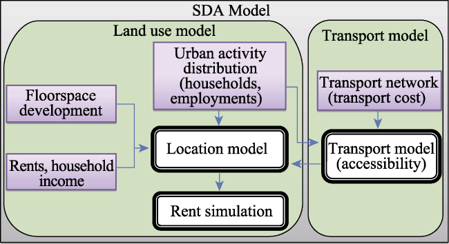
Research on urban spatial evolution has experienced a long history. Since quantitative revolution in geography in the 1960s, model simulation has been adopted to study the evolution of urban space, e.g., Lowry model (Lowry, 1964). In the 1980s, Dentrinos and Mullaly introduced the Volterra-Lotka equation of the predator-prey relationship into the urban system and constructed a dynamic analysis model. In the 1990s, Wegener established the Dortmund model with integrating the models of various subsystems in the city (Li and Ye, 2007). Since the 1990s, with the great breakthroughs in microscopic simulation method based on artificial intelligence, the macroscopic evolution law of urban space has been studied by simulating the behavior of the microcosmic body. Among them, the application of cellular automata (CA) significantly improved the prediction precision (Lowry, 1964; Long et al., 2009), and the multi-agent simulation (MAS) transferred the focus from grid unit to the intelligent agent (Xue and Yang, 2002; Long et al., 2011; Shan and Zhu, 2011; Shen, 2011). The specific application areas include urban space growth (Lowry, 1964; Wu et al., 2008; Long et al., 2009; Yang and Li, 2009), residential space evolution (Liu et al., 2010; Dang et al., 2011; Dong et al., 2011), land use change, traffic flow and urban morphological evolution etc. (Dai and Li, 2009; Chen et al., 2010; Niu and Liu, 2017; Chen et al., 2018). In general, the research results are enriched, and the research methods of the model are constantly innovated, which provides a good scientific support for the development of Chinese cities. However, the application field is relatively dispersed, and the integrated simulation research in various fields is weak. Meanwhile, urban space mentioned in the model refers to the physical meaning of land use (e.g., construction land), which is lack of the comprehensive integration of economic development, population and other urban indicators, and mining of the internal driving force of city evolution. Moreover, in the process of China’s economic reform, urban land use plays an important role in local economic growth. With the exception of the market, the development of the city is mainly guided by the government (Zhang, 2000; Liao and Wei, 2014). Therefore, it is urgent to strengthen the comprehensive integration simulation, and dynamic forecasting the urban space development trend under the policy constraint.
Urban physical space is the spatial projection of socio-economic activities, and the change of urban physical space is the change of spatial distribution of urban socio-economic activities (Lowry, 1964; Wang and Liu, 2011; Wang et al., 2013; Ryan et al., 2015). The implementation of urban space policy will change the distribution pattern of urban socio-economic activities. Therefore, based on socio-economic activities, this study will carry out the research on the integration of urban spatial evolution and provide scientific support for urban space decision-making in the context of rapid urbanization. Urban land use/transport interaction (LUTI) model is supposed to be a powerful tool for urban socio-economic activity space evolution (Liao and Wei, 2014; Geurs and Wee, 2004; Pierlugi, 2013) which is often used for auxiliary decision-making of urban development in developed countries (Niu 2017; Niu and Li, 2017). However, in the domestic, this application is weak, and there is almost no successful application case. For these reasons, we believe that: 1) domestic urban studies, especially quantitative research, started late, and there are few people involved in LUTI model research. 2) Domestic studies have focused on macro issues and qualitative analysis. Although quantitative simulation research has gained more and more attention, the research on complex integration simulation is still weak. 3) LUTI model actually is a computer model to describe the theoretical framework (Lowry, 1964). The key is to simulate infinite city development with computer processing function of the infinite loop. In addition to the professional knowledge of urban development and economic knowledge, the development of the model also requires the technology of computer program development, which hinders the popularization application of LUTI model. 4) The operation of LUTI model requires a large amount of detailed urban land use data, traffic data, and a lot of mathematical calculation (Niu, 2017), which also limits its promotion and use. The development and application of LUTI model for simulating the core function of urban spatial evolution is still very weak, which also provides opportunities and challenges for this research.
The city model developed by Lowry (1964) is a milestone in the development of LUTI model, which is named as Lowry model. As a static model, Lowry model predicts the development trend of urban space at a certain time point based on the assumption of many variables, characterizes the traffic condition between locations with displacement distance, and evaluates the attractiveness of land based on market rules. The above aspects have become the main focus of the expansion of scholars. As far as the implementation of LUTI model is concerned, it is necessary to build a dynamic model in order to realize the annual prediction for the future, and predict the annual situation according to the annual change of variables. In addition, from the perspective of model implementation technology, research on “activity-based” LUTI model is considered as a new development trend (Pierlugi et al., 2013; Brand et al., 2014). The “activity-based” LUTI model evaluates urban location characteristics according to the needs of various socio-economic activities, and the same location has different values for different urban activities. In this regard, common methods of evaluating location advantages using spatial distance are not adequate (e.g., distance to CBD, or traffic station).
In view of the domestic demand for the rapid development of urbanization, and the domestic research status and development trend of LUTI model, this paper constructed the “activity-based” LUTI model, which is known as Spatial Distribution of the Activity (SDA). The main urban activities considered in this study are household and employment. The SDA model is a dynamic model, which is used to simulate the urban spatial evolution process and predict the distribution pattern of socio-economic activities. Then the influence of urban land-use policy on urban space is simulated with Beijing as a case study area.

2 Origin of LUTI model

LUTI model is an integrated framework for theory, data and algorithm, which is used to describe the interaction process between two major components of urban space (transportation and land use system). The word “land use” of LUTI is not the physical meaning of land use (e.g., construction land and farmland, etc.), but rather refers to the user of “urban space”: socio-economic activities. “Urban space” usually refers to the floorspace, rather than land (Simmonds and Feldman, 2011). In some research, “land use” refers to physical meaning of land use, but such models do not belong to LUTI model (Landis, 2001; Niu and Li, 2017).
The LUTI model contains essentially interrelated land use model and traffic model. In the 1950s, the American scholar Hansen (1959) put forward the thought about the interaction of urban land use and transportation: the urban land use pattern (such as residential, industrial and commercial distribution, etc.) determines the space separation about the location of the human activities (live, work, shopping, etc.). All kinds of urban activities need to interact through traffic, and the transportation convenience determines the location selection of activities, so as to lead to the changes of land use system. Conversely, the land use system changes also affect the traffic system. Then the equilibrium is reached by such interaction. This idea swept the American planning area and laid the theoretical framework of LUTI. Subsequently, in the early 1960s, quantitative simulation has received unprecedented attention in the field of urban planning. In 1964, Lowry first tried to establish a city model (Lowry model) using computer technology based on LUTI theory, which became a milestone in the development of LUTI model. Lowry model considers urban space is composed of traffic network and land use, and divides socio-economic activities into three kinds: household, basic production department and service department. Given the location of the basic department, the spatial distribution of residents and service departments shall be given. The Lowry model contains the residential location model and the service sector location model, which are nested with each other.

3 Implementation of the SDA model

3.1 Model components

The SDA model was designed to predict the changes of the spatial distribution of urban activities when urban land use or traffic system changes. The assumptions of the model are: urban activities tend to location with higher utility; location utility is influenced by factors such as the rent or traffic accessibility; the change of location utility leads to the change of socio-economic activity distribution.
The SDA model divides urban activities into two categories: household and economic activities, among which economic activities include education, medical care, research and service industries. Housing floorspace is corresponding to household, and commercial floorspace is corresponding to various sectors of the economy, including companies, hospitals, schools, research institutes etc. (which are all called enterprises in this paper). In addition to the household, all kinds of activities can provide jobs, so economic activities are also collectively known as employment activities. The scale of economic activity is calculated according to the number of jobs. For example, the number of economic activities in a zone is 5000, that is, there are 5,000 jobs in the zone.
As shown in Figure 1, the SDA model includes four sub-models: traffic sub-model, household location sub-model, economic activity location sub-model and rent forecast sub-model. The specific details of each sub-model will be further discussed below.
Figure 1 Components of the SDA model

3.2 Transport model

Based on the spatial distribution of urban road network and socio-economic activities (household and economic activities), the traffic sub-model is adopted to evaluate the accessibility of the zone, which is used to represent the convenience of travel from the zone. The definition of accessibility in this paper is that the convenience of engaging in various socio-economic activities in the zone. For family residents, the accessibility of the zone reflects the convenience of working and travelling (household accessibility). For economic activities (enterprises), the accessibility of the zones reflects the convenience (enterprise accessibility) of the zones to be reached by residents as the end point. Accessibility is determined by the spatial distribution of the conditions and opportunities. For household, the accessibility is affected by the spatial distribution of surrounding job opportunities; for enterprise, it is affected by the spatial distribution of surrounding residents. Accessibility evaluation is based on activities and zones, that is, traffic accessibility evaluation is different for different activities in the same zone. The SDA model uses formula (1) to evaluate traffic accessibility.
${{A}_{i}}=\frac{1}{\lambda }\ln \left\{ \sum\limits_{j}{{{W}_{j}}}\exp \left( \lambda \cdot g{{c}_{ij}} \right) \right\}$ (1)
where Ai is the traffic accessibility of zone i; Wj is the weight of zone j (for household, Wj is the number of jobs in zone j; for enterprise, Wj is the number of residents in zone j), gcij is the minimum tolls between zone i and zone j, which reflects the traffic conditions between zones. gcij, which is calculated by GIS software with calculation result as a M × M order matrix (M is the number of zones), is the shortest transit time between two zones
Formula (1) is a logarithmic sum constructed in the form of logit model. Accessibility Ai has the same dimension as transport expense gcij. Therefore, the higher the accessibility evaluation value, the higher the cost and the worse the accessibility. According to formula (1), the coefficient is set as a negative value. With the increase of traffic cost gcij, the value of the exponential function term will gradually decrease, and the weight of zone j will be further weakened. Therefore, if zone j is difficult to reach for zone i (the transportation cost of gcij is high), the opportunity distribution of j is meaningless for zone i. Formula (1) is used to calculate accessibility without setting a threshold.

3.3 Location cost

Location cost refers to the economic cost of households or enterprises choosing a location. When families dominate their income, the proportion of consumer spending on housing and others will be adjusted for utility maximization. Therefore, in this study, household spending is divided into two categories: housing consumption (rent) and other consumer goods or services (ogs). The Cobb-Douglas (1933) equation is adopted to calculate consumption utility (U). The calculation of consumption utility does not take transportation cost into account because transportation cost has been included in the evaluation of location utility and appeared in traffic accessibility.
$U_{i}^{{}}={{\left( a_{i}^{H} \right)}^{\beta _{{}}^{H}}}\cdot {{\left( a_{i}^{O} \right)}^{\beta _{{}}^{O}}}$ (2)
$\beta _{{}}^{H}+\beta _{{}}^{O}=1$ (3)
where Ui is the consumption utility of households in zone i;$a_{i}^{H}$is the average household area; $a_{i}^{O}$ is the average household spending on ogs; βH and βO represent the tendency of households to allocate income to housing and ogs consumption, and the sum of them is 1. In this case, the two are attached to empirical values based on research experience.
For the company, the most important thing is to maximize profits. The rent is adopted to calculate its location cost.

3.4 Household location model

The household location (residential location) model is used to calculate the spatial distribution of urban families and determine the number of families in each zone. The factors considered in the model include traffic accessibility and rent (consumption utility). The weight of each influencing factor is a representative value, which is called location utility (V). The utility of location reflects the value of location in a certain type of economic activity. Different applications will have different emphases on variable selection, and even consider other variables (such as environmental quality, etc.).
Choice of household location tends to zones which already have household, and it is also affected by the location utility change (incremental) and the number of homes available (household distribution). Hence, the incremental model is adopted. In addition, it is impossible for researchers to know how each individual evaluates its location, hence, we chose the probabilistic discrete selection model. The probabilistic discrete selection model considers that the error terms are distributed uniformly and independently. Thus, as a housing consumer, the household’s evaluation of location can be regarded as a function of a series of influencing factors. Based on this, the household location model is constructed as follows:
$\Delta \mathop{V}_{t+1,i}^{H} = \mathop{\theta }_{{}}^{U} ( \mathop{U}_{t+1,i}^{{}} - \mathop{U}_{ti}^{{}}) + \mathop{\theta }_{{}}^{A} ( \mathop{A}_{t+1,i}^{H} - \mathop{A}_{ti}^{H} )$ (4)
$H(L)_{t+1,i}^{{}} =H(M)_{t+1}^{{}} .\frac{H_{ti}^{{}}.F(A)_{t+1,i}^{H}. exp(\Delta \mathop{V}_{t+1,i}^{H})}{\underset{i}{\mathop \sum }\, \{H_{ti}^{{}}.F(A)_{t+1,i}^{H}. exp(\Delta \mathop{V}_{t+1,i}^{H})\}}$ (5)
where $\Delta \mathop{V}_{t+1,i}^{H} $is the variable of household location utility in zone i within the time period of t+1, which is the weight of the change of household accessibility and location cost, with θ as the weight coefficient. H(L)t+1,i is the number of families that move into zone i within the time period of t+1. H(M)t+1 is the total number of families who move in cities during the period of t+1. Hti is the number of households in zone i during the period t (the previous period); $F(A)_{t+1,i}^{H}$ is the number of available housing floorspace during the period of t+1.

3.5 Location model of economic activities

Economic activity location model is used to determine the spatial distribution of economic activities and the amount of economic activity in each zone. Economic activity distribution is affected by enterprise location. As mentioned before, this study focuses on the interaction between “living-work”, with an assumption that enterprise location choice is affected by household distribution. Then the enterprise location model is similar to the household location model, as shown in formula (6).
$E(L)_{t+1,i}^{{}} =E(M)_{t+1}^{{}} .\frac{E_{ti}^{{}}.F(A)_{t+1,i}^{e}. exp(\Delta \mathop{V}_{t+1,i}^{e})}{\underset{i}{\mathop \sum }\, \{E_{ti}^{{}}.F(A)_{t+1,i}^{e}. exp(\Delta \mathop{V}_{t+1,i}^{e})\}}$ (6)
where E(L)t+1,i is the number of economic activities that move into zone i within the time period of t+1; $\Delta \mathop{V}_{t+1,i}^{e}$ is the variable in location utility of an enterprise in zone i within the time period of t+1. Similar to the utility of household location, the utility of enterprise location is calculated by enterprise accessibility and rent, that is, household accessibility and consumption utility in formula (4) are changed into enterprise accessibility and rent fees; E(M)t+1 is the total amount of economic activities that need to be relocated in the city during t+1 period. $F(A)_{t+1,i}^{e}$ is the number of commercial floorspace available in zone i during t+1 period; Eti is the amount of economic activity in zone i during the period of t (the previous period)

3.6 Rent model

Rent or housing price is the key factor that affects the location utility of urban socio-economic activities. After the urban activity distribution calculated by the location model, the rent will inevitably change as the urban activity distribution changes and the supply and demand change. The rent model is used to adjust the rent changes in real time. The new rent is used again to calculate the spatial distribution of urban activities. Based on the demand and supply of real estate, the rent model is adopted to predict the new rent by referring to the previous rent (Mumtax, 1995; Albouy, 2014). Based on the rent model, the greater the demand for real estate in a zone, the higher the rent in the zone. Formula (7) shows the housing rent prediction model, which is similar to the commercial rent model.
$\mathop{{{r}'}}_{pi}^{H} = \mathop{r}_{pi}^{H} \left[ \frac{\mathop{a}_{pi}^{H} . H(L)_{pi}^{{}}}{F(A)_{pi}^{H}} \right]$ (7)
where $\mathop{{{r}'}}_{pi}^{H}$ is the estimated rent of zone i. $\mathop{r}_{pi}^{H}$ is the last rent (the location model is the recursive process, as shown in Figure 2). The variable a is the current household distribution density; H(L)pi is the number of families moved into zone i; F(A)pi is the total area of currently available residential floorspace.
Figure 2 Algorithm of the SDA model
Commercial rent adjustment equation can be obtained with the household variable being replaced by the corresponding economic activity variable, i.e., replacing H(L) into E(L), rH into re, aH into ae and F(A)H into F(A)e.

3.7 Algorithm of location model

As mentioned before, the urban space evolution process is an interaction process of land use and transportation system. The transportation system affects the land use system through accessibility (socio-economic activity distribution), and land use system also affects the traffic system. These two form a cycle with an equilibrium state. Any change in factors will lead to a new balance in the urban system (Torrens, 2000). The location model algorithm is based on this idea. The process of urban land use and traffic interaction corresponds to the iterative process of the algorithm (Figure 2).
As shown in Figure 2: traffic accessibility is calculated by traffic model based on the distribution of socio-economic activities and traffic costs; the location cost (household consumption utility and company location cost) of each zone is calculated according to the rent and household income; then, the location utility of each zone is calculated based on traffic accessibility and location cost; the spatial distribution of economic activities is calculated by location model based on the location of the utility and the floorspace distribution.
At this point, the density distribution of urban socio-economic activities changes, and further leads to changes in rent. The above process is repeated until the completion condition is satisfied and the program stops. At this time, the state of urban space is the predicted value. Condition for the end of a cycle refers to that the results of two cycles do not change or change very little, in this case, the model outputs the predicted value of the next period (such as the next year).The predicted value of the model, together with the policy scenario setting (policy scenario in year t+2), can further predict the situation of year t+2. By analogy, the future urban space situation can be predicted year by year.

4 Case study: policy scenario experiments

4.1 Study area

Beijing was taken as a case area with a total of 18 districts (counties) and later changed to 16 in 2010. In this paper, eight urban districts and their surrounding suburban districts are taken as research areas. Using Jiedao (township) as scale, there are 239 Jiedaos (zones) as shown in Figure 3.
Figure 3 Floorspace development of Beijing
Spatial data of this study includes administrative division, road network data (including highways, urban expressways, national highways, provincial roads, county roads, metro lines and other traffic line at all levels) in the case study area. The minimum transportation costs (gc) between every two zones are estimated based on the network. The result of traffic cost evaluation is a 239 × 239 matrix.
In terms of socio-economic data, China’s sixth population census data is still the most detailed data. As for the economic activity distribution data, POI (Point of Interest) data is obtained through remote access interface (API) provided by the electronic map suppliers, including the basic information and spatial location of the various units. Then the POI is matched with economic census data, so as to obtain the spatial information and attribute information for each unit. For the few POI data mismatch, combining with field investigation, interpolation is adopted. The data include almost all companies, schools, research institutes, hospitals and other units in Beijing. With this data, the detailed distribution of various kinds of employment in Beijing can be obtained by using GIS technology.

4.2 Policy scenarios

Model can be used to test land-use policy, traffic policy or a combination of both. Due to the relatively slow changes in traffic system, as an application case, this paper will simulate the influence of current land-use policy on urban space.
Land-use policy: Corresponding to the classification of socio-economic activities, this study divides land use (real estate development) into two categories: housing development and commercial development. Area is used as a measurement unit, e.g., the number of housing developments is 200,000 square meters in a certain zone in a certain year. Each year, the government gives land to developers, and each land sold is generally used for its purpose (for residential or commercial purposes, etc.) and development area is specified. Land transaction data in Beijing for the past five years (2009-2013) have been collected and prepared, from which the number of various kinds of real estate developed is calculated in each zone every year. The average annual development of each zone is calculated as the future annual real estate development. According to Figure 3, land use development is mainly distributed outside the main urban areas, between the Fifth and Sixth Ring Roads, as well as counties and cities in suburban counties. This is also in line with the current macro-policy of easing the socio-economic activities, establishing multi-centers and easing traffic congestion in the main urban areas of Beijing. Another important reason is that the main urban areas are already in a state of high development, and further development and construction is difficult and costly. Compared with housing development and commercial development, commercial development is more decentralized, which can be predicted to lead to further decentralization of employment distribution. Commercial development is widely found in the south of the city.
In addition to transportation and land-use policy, annual growth of urban socio-economic activity also needs to set. Taking into account the average speed of population and employment growth in recent years, this paper set the urban households and economic activities of annual growth rate is 0.023 and 0.020, respectively.

4.3 Results

Based on the above scenario, the SDA model is adopted to forecast the distribution pattern of population and economic activity every other until 2030. At the end of the paper, the forecast results of each year are attached. The following is a brief analysis of the predicted results.
(1) Population distribution
The forecast of household population distribution in Beijing in 2030 is shown in Figure 4a. By 2030, most of the population will still be in the main urban areas within the Fifth Ring Road. This is because historically the main urban areas have been highly developed, with a large number of population and economic activities, and high traffic accessibility. When the population increases year by year, there will also be some people settling in the region. With the original population base, the main urban area is still the most densely populated area. As can be seen from Figure 4, the traffic route has a great influence on the spatial distribution of residents, and the population tends to the location along the traffic line. A few zones away from the city center also have the high population density, which are usually suburban county towns, such as north zone (23) and south zone (24) in Changping, Guangming (77) and Shengli in Shunyi (78), and Yingfeng in Fangshan (51), etc.
Figure 4 2030 Population distribution forecasted
Figure 4b shows the percentage change of population in each zone in 2030 compared to the population growth model in 2010. As can be seen from the figure, with the annual growth of the population, more and more people tend to move beyond the fourth ring road. With considering the factors of the rent, transportation accessibility and property distribution by the SDA model, it can be concluded that the city has been highly developed with high population density, causing further less housing construction. In addition, high rents also hindered the further population agglomeration. The suburbanization of new population is consistent with land-use policy. The development of a large number of houses in the suburbs has resulted in a decrease in rent. Moreover, a large number of commercial floorspace construction has attracted a large number of economic activities, which has further improved the accessibility of household transportation in the region
According to Figure 4b, it can be concluded that the areas with relatively rapid population growth are mostly located along the Sixth Ring Road and between the Fifth and Sixth Ring Roads. And the growth is significantly higher than the surrounding areas, e.g., Nanshao (89), Mapo (73), Houshayu (236), Beizang (92), Changyang (97), Liangxiang (98), and Yizhuang (173). According to the present land-use policy, these areas will gradually develop into sub-centers of the city. The distribution of these potential sub-centers is consistent with the current government’s goal of developing a multi-center structure to ease traffic congestion. According to the simulation results, Yizhuang will gradually have more people agglomerated, and the economic activity simulation has a similar trend.
(2) Economic activity distribution
Figure 5a shows the distribution pattern of economic activities in 2030. By 2030, most economic activities will still be in the main urban areas within the Fourth Ring Road. However, the distribution of economic activities in the periphery is mainly concentrated in areas around the main trunk traffic lines and areas with good accessibility. In addition to the main urban areas, there are relatively concentrated economic activities in the suburban areas, such as Yizhuang (173), Huangcun (95), Wangjing (140) and Jinding (233). In the context of land-use and development policy (see Figure 3), these zones have a high amount of property development, which leads to a decrease in rent and attracts more companies to move in. According to the predicted results, the density of economic activities in these areas is also significantly higher than that in the surrounding areas.
Figure 5 2030 economic activity distribution forecasted
Figure 5b shows the growth model of economic activities in 2030. The figure shows that employment growth percentage of a large number of zones in central and southwestern parts is less than zero, indicating that economic activity in these areas will be lower in 2030 than in 2010. Compared with land-use policy, commercial floorspace development in these zones is less or none. And for other suburbs where there are more developments, the rent must decline. The companies tend to zone with low rent so as to reduce the cost of location, which led to a rapid increase in employment activity in the suburbs. The simulation results are also consistent with the current planning objectives of evacuation economic activities in the main urban areas, which further proves the effectiveness of the model.
Comparing the growth model of population (Figure 4b) with the growth model of economic activities (Figure 5b), we can find that the growth model of economic activities is more dispersed in space, and the growth rate in the suburbs is larger. It can be concluded that the location of enterprises is more sensitive to location cost (rent) driven by the market. With the development of commercial real estate in the surrounding areas, the rent will decrease, and a large number of companies will move to the suburbs to reduce their location costs. What can be predicted is that the migration of economic activities will further drive the migration of family population. In addition, in Figure 5b, it can be found that areas with high growth intensity of economic activities are mostly distributed on both sides of the Sixth Ring Road, which is similar to the commercial development model (Figure 3). It reflects that the government can guide the urban spatial distribution of economic activities through land-use policy, thereby indirectly control the spatial distribution pattern of urban economic activities.

5 Discussion

5.1 Validity and usefulness

In the calibration process, the coefficient is adjusted according to the comparison of the predicted and observed values (actual values). Apart from the year 2010, the other years do not have detailed Jiedao scale population data, but the rent plays a crucial role in the model, so the rent data is used to verify the simulation results of the model. In each test, the coefficient is adjusted according to the difference between the predicted rent and the observed rent. For example, if the predicted value of rent in all zones is larger than the observed value, and the R test is less than 0.50, the coefficient of positive correlation with rent will be reduced by 0.5%, and vice versa. Other coefficient adjustments are similar, until the predicted value is close to the actual observed value. In comparison of the predicted value of 2014 with the actual observed value, the correlation (R2) was 0.7.
This paper predicts urban space changes according to the law of the market, but the rent of the city, which is too high or too low, is not the result of market factors. Hence, all such data is excluded from the actual data in the process of pretreatment. This process enhances the correlation between the predicted value and the actual value.
We acknowledge that the SDA models are difficult to predict the future accurately, and we do not believe that there are models that can predict the future accurately. A city is a huge complex system. Its development process is affected by many factors, including unpredictable factors. Therefore, for the application of the model, the relative value of its simulation is more meaningful than the absolute value. The relative value includes two aspects. One is to compare different policy situations and find their differences. The other is to calculate the relative size of simulation values of different zones. These two points are very helpful to assist decision making. The hypothesis of the case study in this paper is that the past land-use policy will extend to the future, which is set for the application of the model and does not represent the official policy.
LUTI theory is considered to describe the law of urban space development (Simmonds and Feldman O, 2011; Brandi et al., 2014; Liao and Wei, 2014). Therefore, modification and calibration to different degrees can be further applied to other cities under the framework of this model. Through more case application comparisons, the model can be improved step by step in variable selection and parameter setting. This study is helpful to further popularize and apply LUTI model in China, assist urban spatial decision-making, and enrich and develop the research contents of domestic urban sustainable development simulation and analysis discipline.

5.2 Limitations and development

Compared to the Lowry model, the SDA is a dynamic model. The SDA model allows the elements to change over time and to predict different years of urban space, but the SDA model is still a balance model, and iterative process of the model ultimately converge to a state of equilibrium. Some people believe that although urban space development tends to be balanced, it will never reach equilibrium due to the disconnection between supply and demand (Kryvobokov et al., 2013). Therefore, the SDA model belongs to the “quasi-dynamic model”.
Location utility evaluation mainly considers traffic accessibility and location cost. However, there are many factors influencing the location selection of urban activities, such as household location selection, which is affected by family member structure, residential comfort and environment. Therefore, including a variety of factors is the future direction of development. This work will also face the problem of data acquisition, model algorithm will tend to be complex, running time will increase.

5.3 Optimization of transport model

Due to limited space, the case does not consider the traffic policy scenario. Traffic is the key factors influencing the urban socio-economic activity location, the change of traffic (such as the construction of roads or subway) certainly changes the accessibility of cities, especially accessibility along the way, and ultimately affects the spatial distribution of urban activities. According to the traffic sub models in the SDA model, the change of the traffic system will affect the cost of urban traffic and the traffic accessibility, and ultimately change the simulation results. Hence, the SDA model also can be used for transport policy test. Compared to the land use system, the urban traffic system changes more slowly, therefore, in the process of model operation, it does not need to run traffic model year by year, which only needs to operate in the year when the transportation system changes, such as the year when a highway opens.
The traffic model uses the speed of “car” to calculate the traffic time. On a more subtle level, city have different socio-economic groups, their travel corresponds to different traffic patterns, e.g., walking, cycling, public transport, driving etc., which led to their spatial distribution being different. Therefore, the implementation of multi-mode traffic simulation analysis is a problem faced by the SDA model. There are many researches and fierce competitions in the field of transportation, and there are a lot of mature traffic software, such as START and TRAM.
Traffic cost parameters in traffic accessibility evaluation of the SDA model (gc, see formula 1) provide interface with existing intelligent traffic models, which can use mature intelligent transportation model to evaluate the urban traffic. The integration with the intelligent traffic model will further enhance the function of this model.

5.4 Modeling changes in total urban activities and location

This paper uses the growth rate to calculate the total number of households. However, the change of the total number of households is affected by both the local population change and the floating population (moving in and out). In order to achieve a more accurate model, it is necessary to establish a population flow model to simulate the urban and external population flow, and a population change model to simulate the local household transit. The same problem is also in the economic activity. Influencing factors for location selection of local household relocation are different with those for migrant population, hence, the location model needs to explore the location choice of local population flow and the floating population respectively.

6 Conclusions

Based on the interaction theory of land use and transportation, the SDA model is constructed to simulate the urban spatial evolution process. Taking Beijing as an example, based on the land development trend in recent years, the distribution pattern of population and economic activities in the future is predicted. The research shows that the SDA model can quantitatively predict the number of population and economic activities in each zone, which provides a good tool for the policy test of urban land use. The core work of this study is the construction and development of the SDA model. The SDA model mainly includes four sub-models: traffic sub-model, household location sub-model, economic activity location sub-model and rent forecast sub-model. The SDA model is based on the “active” LUTI model. The evaluation of location value based on “activity” model is based on various activity demands, such as a location for different households has different values, which differ from the physical location (e.g., the distance to the CBD). From the perspective of the development process of the model, the construction of active SDA model conforms to the new trend of LUTI model development (Wegener, 2004). As a preliminary exploration of the application of LUTI theory to Chinese cities, this study is conducive to promoting the development of LUTI model and its application in China, and enriching the research contents of urban space simulation analysis. The SDA model will also be improved gradually in the application.

The authors have declared that no competing interests exist.

[1]
Albouy D, Ehrlich G, 2014. Housing demand and expenditures: How rising rent levels affect behaviour and costs-of-living over space and time. NBER. Available at: (accessed 14 March 2016.

[2]
Brandi A, Gori S, Nigro M et al., 2014. Development of an integrated transport-land use model for the activities relocation in urban areas.Transportation Research Procedia, 3: 374-383.The study presents a new Land Use 鈥 Transport Interaction (LUTI) planning model to provide an effective decision support system tool for the Urban Planning Administrations and to promote the use of the public transport system in urban areas. The idea is to relocate a subset of activities from urban zones with strong attraction, but poorly connected by the existing mass transit system, to urban zones close to the existing mass transit links with available residual capacity. This residual capacity is the main variable that indicates location and intensity of activities to be moved. The model has been applied for the real case study of the city of Rome in Italy. Results demonstrated the capability of the model to be a useful support system to suggest activities relocation pursuing the goal of sustainability for a short-term horizon.

DOI

[3]
Chen W, Liu W D, Ke W Q et al., 2018. Understanding spatial structures and organizational patterns of city networks in China: A highway passenger flow perspective.Journal of Geographical Sciences, 28(4): 477-494.The use of multi-perspective and multi-scalar city networks has gradually developed into a range of critical approaches to understand spatial interactions and linkages. In particular, road linkages represent key characteristics of spatial dependence and distance decay, and are of great significance in depicting spatial relationships at the regional scale. Therefore, based on highway passenger flow data between prefecture-level administrative units, this paper attempted to identify the functional structures and regional impacts of city networks in China, and to further explore the spatial organization patterns of the existing functional regions, aiming to deepen our understanding of city network structures and to provide new cognitive perspectives for ongoing research. The research results lead to four key conclusions. First, city networks that are based on highway flows exhibit strong spatial dependence and hierarchical characteristics, to a large extent spatially coupled with the distributions of major megaregions in China. These phenomena are a reflection of spatial relationships at regional scales as well as core-periphery structure. Second, 19 communities that belong to an important type of spatial configuration are identified through community detection algorithm, and we suggest they are correspondingly urban economic regions within urban China. Their spatial metaphors include the administrative region economy, spatial spillover effects of megaregions, and core-periphery structure. Third, each community possesses a specific city network system and exhibits strong spatial dependence and various spatial organization patterns. Regional patterns have emerged as the result of multi-level, dynamic, and networked characteristics. Fourth, adopting a morphology-based perspective, the regional city network systems can be basically divided into monocentric, dual-nuclei, polycentric, and low-level equilibration spatial structures, while most are developing monocentrically.

DOI

[4]
Chen Y M, Li S Y, Li X, 2010. Simulating compact urban form using cellular automata (CA) and multi-criteria evaluation: A case study in Dongguan.Acta Scientiarum Naturalium Universitatis Sunyatseni, 49(6): 110-114. (in Chinese)

[5]
Cobb C W, Douglas P H, 1928. A theory of production.American Economic Review, 18(Suppl.): 139-165.

[6]
Dai J C, Li X, 2009. Multi-agent systems for simulating traffic behaviors.Chinese Science Bulletin, 54(21): 3380-3389. (in Chinese)Multi-agent systems allow the simulation of complex phenomena that cannot be easily described analytically. As an efficient tool, the agent-oriented traffic models have emerged to investigate vehicular traffic behaviors. In this article, a new agent-based traffic simulation model is proposed for solving the traffic simulation problems. A vehicle with the driver is represented as a composite autonomous agent in this model. Different from the classical car-following principles, vehicle-agent moving approaches are proposed instead of particle-hopping techniques. This model defines reasonable acceleration and deceleration rates at any certain condition. In this simulation, this can offer a natural, even cognitive way to follow the leader and switch lane. The simulation results have verified that this model has achieved more realistic results without loss of accuracy than those obtained from the cellular automata traffic models. This model can provide better simulation performance than the traditional vehicle-following models which are used to investigate the nonequilibrium traffic flow. A comparison of the real flow with the simulated freeway flow and lane capacity highlights the validness of this model.

DOI

[7]
Dang Y X, Zhang W Z, Wu W J, 2010. Residents housing preferences and consuming behaviors in a transitional economy: New evidence from Beijing, China.Progress in Geography, 30(10): 1203-1209. (in Chinese)During the past two decades Chinese cities have experienced rapid urbanization process and dramatic rising of job and residential mobility.Recent literatures have paid attention to spatial features of home-work sep-aration and residential relocation choices in transitional Chinese cities.Nonetheless,research on this issue has been limited by the lack of systematic data-especially large scale micro-survey data,on residents’social behav-iors as well as other related aspects.In this paper,based on a multi-time survey datasets conducted from 10000 residents in 2009,we establish a mono-centric city’s household residential location demand function model to quantitatively explore the evolution of urban residential housing consumption and its mechanism.Based on the analysis,we find that the balance between commuting costs and housing costs has become the core variable in the residential decision-making process.Other residents’properties,like income,all have significant influenc-ing power on residents’relocation decisions.To be more specific,high-income families would like to pay high-er housing costs to reduce commuting costs.Median-income families value housing costs and are less influ-enced by commuting costs,organization offered housing costs and commuting costs,unit housing residents and affordable housing residents are more inclined to pay higher housing costs to reduce commuting costs while commercial housing residents choose to live in houses with lower housing costs.The empirical results have veri-fied the efficiency of the residents housing consumption in the transitional China and provided the information for future land and housing policy making.

DOI

[8]
Ding C, Lichtenberg E, 2011. Land and urban economic growth in China.Journal of Regional Science, 51: 299-317.ABSTRACT Land to accommodate urban development in China is provided through requisitions by government officials, suggesting that land availability may be a constraint on urban economic growth. An econometric model of urban GDP growth suggests that land has constrained economic growth in coastal areas but not elsewhere. Elasticities calculated from the estimated coefficients indicate that land availability has a larger proportional impact on economic growth than domestic and foreign investment, labor supply, and government spending. The estimated parameters provide evidence about arbitrage opportunities created by discrepancies between urban land value and compensation for requisitioned rural land, suggesting rural unrest associated with conversion of farmland to urban uses may have some economic roots.

DOI

[9]
Dong G P, Zhang W Z, Wu W J et al., 2011. Spatial heterogeneity in determinants of residential land price: Simulation and prediction.Acta Geographica Sinica, 66(6): 750-760. (in Chinese)Hedonic land price models typically impose a spatial homogeneous price structure on land characteristics throughout the entire land market. However, there are increasing theoretical and empirical evidences that the marginal values of many crucial attributes of land parcels vary across space. Theoretically, localized and inelastic land supply results in spatial mismatch between demand and supply of land with certain attributes, which causes the spatial heterogeneous effects of these attributes. In this paper, we establish a series of models to evaluate the determinants of residential land price and the spatial heterogeneity of the determinants. First, we use hedonic models to diagose the determinants of residential land price. Second, we use the spatial expansion models and geographically weighted regression model (GWR) to depict the spatial instability in the impacts of land attributes. Third, we compare the prediction accuracy of the two models by predicting the land price of 10% random selected land parcels. We take Beijing as a case study and use the information of auctioned residential land parcels during 2004-2009 and GIS data of Beijing's public facilities. Based on the analysis, several conclusions are drawn as follows. 1) Spatial dependence of local residential land price and the spillover effect of local commercial land exert great effects on the residential land price, while the impact of the distance on CBD is insignificant, which indicates that the residential land market is probably local rather than global. 2) Among several public facilities, in terms of Nearest-Distance Accessibility Criteria, only the local prime elementary school, park and rail transit accessibility have a significant effect on the residential land price. 3) There is an obvious spatial pattern in the impacts of the land attributes on the land price, which is an evident signal of existence of land submarkets. 4) As the spatial expansion model imposes a fixed and definite function of spatial coordinates on the spatial heterogeneity in the marginal effect of land parcel attributes, it does not perform as well as GWR models in depicting spatial variation and prediction accuracy. GWR models perform best in explaining the land price variation, depicting spatial heterogeneity and prediction accuracy comparing to hedonic models and spatial expansion models. Also, GWR models provide a useful framework for delineating residential land submarket boundaries.

DOI

[10]
Gao J, Wei Y D, Chen W et al., 2014. Economic transition and urban land expansion in provincial China.Habitat International, 44: 461-473.China has undergone economic transition characterized by marketization, globalization and decentralization, which has resulted in profound change in land use and urban space. This paper integrates globalization, institutional change, and China's economic transition to better understand urban land expansion in China. We use land use survey data in Jiangsu province at the county level to shed the light on the impact of economic transition on land use change and urban land expansion in China. We have found that a dramatic land use change in Jiangsu characterized by rapid urban land expansion, particularly Sunan (Southern Jiangsu) and municipal districts. This can be well explained by government policies including tax reform and intergovernmental competition, the participation in the global economy, and the development of a market economy. We have also found that urban land expansion has a temporal dimension, and was driven mainly by local governments in the early stage of the reform, followed by marketization, and more recently globalization after China's entry into the World Trade Organization (WTO). (C) 2014 Elsevier Ltd. All rights reserved.

DOI

[11]
Geurs K T, Wee B V, 2004. Land-use/transport interaction models as tools for sustainability impact assessment of transport investment: Review and research perspectives.European Journal of Transport and Infrastructure Research, 4(3): 333-355.

[12]
Hansen W G, 1959. How accessibility shapes land use.Journal of the American Institute of Planners, 25: 73-76.

DOI

[13]
Jing W, Jianzhong L, 2011. Study on the urban expansion and model of Lianyungang city based on the multi-temporal remote sensing images.Procedia Environmental Sciences, 10: 2159-2164.This study, selecting Lianyungang City as the object of study, the multi-temporal TM/ETM+ images as the main source of data, studied the temporal and spatial features and the model of urban expansion. The results indicated that between 1987and 2009 in Lianyungang, the expanding speed increased each year; the city center of Lianyungang moved northeast; there were the features of low urban compactness weak stabilization, high fractal dimension and too complicated edge of city. The analysis to the model of urban expansion indicated that the urban expansion was obviously bicentric, and take traffic roads as development axis. The two urban districts, Xinpu and Eastern districts of Lianyungang came closer. Therefore the expanding mode of Land use in Lianyungang showed distinctive expansion in the axial direction and Layered spread.

DOI

[14]
Kryvobokov M, Chesneau J B, Bonnafous A et al., 2013. Comparison of static and dynamic land use-transport interaction models: Transportation research record.Journal of the Transportation Research Board, 2344(1): 49-58.

DOI

[15]
Landis J, 2001. CUF, CUF II and CURBA: A family of spatially explicit urban growth and land-use policy simulation models. In: Brail R K, Klosterman R E eds. Planning Support Systems: Integrating Geographic Information Systems, Models and Visualization Tools. Redlands, CA: ESRI Press.

[16]
Li X, Ye J A, Liu X P et al., 2007. Geographical Simulation Systems: CA and MAS. Beijing: Science Press. (in Chinese)

[17]
Liao F H F, Wei Y H D, 2014. Modeling determinants of urban growth in Dongguan, China: A spatial logistic approach.Stochastic Environmental Research and Risk Assessment, 28(4): 801-816.This paper examines spatial variations of urban growth patterns in Chinese cities through a case study of Dongguan, a rapidly industrializing city characterized by a bottom-up pattern of development based on townships. We have employed both non-spatial and spatial logistic regression models to analyze urban land conversion. The non-spatial logistic regression has found the significance of accessibility, neighborhood conditions and socioeconomic factors for urban development. The logistic regression with spatially expanded coefficients significantly improves the orthodoxy logistic regression with lower levels of spatial autocorrelation of residuals and better goodness-of-fit. More importantly, the spatial logistic model reveals the spatially varying relationship between urban growth and its underlying factors, particularly the local influence of environment protection and urban development policies. The results of the spatial logistic model also provide clear clues for assessing environmental risks to take the local contexts into account.

DOI

[18]
Liu X P, Li X, Chen Y M et al., 2010. Agent-based model of residential location.Acta Geographica Sinica, 65(6): 695-707. (in Chinese)Multi-agent system (MAS) is a powerful tool capable of analyzing and simulating complex systems,and has been extensively applied in the regime of social sciences.In this paper we present an agent-based model of residential location (ABMRL) and apply this model to study the dynamic changes of residential location and land price,aiming to explore and simulate the complicated spatial decision-making behaviors in residential location as well as the evolution process of urban residential segregation,which is resulted from interactions among residents and between residents and geographical environment.The ABMRL model consists of agent layer representing various classes of residents and cell automata layer representing geographical environment,which correspond to the two basic elements in man-earth relationship,i.e.,human being and natural environment.In this model,psychological concepts were introduced for study of the behaviors of residential location,as it is generally considered that residential relocation is facilitated by internal social and economic pressure and external residential environment.ABMRL model was used to simulate and validate a series of classic urban theories such as residential segregation,concentric urban space structure,gentrification,etc.,and to simulate the evolution of residential segregation and dynamic changes in land price in Haizhu District of Guangzhou City,which was taken as a test example for the study.

DOI

[19]
Long Y, Han H Y, Mao Q Z, 2009. Establishing urban growth boundaries using constrained CA.Acta Geographica Sinica, 64(8): 999-1008. (in Chinese)Extensive urban planning implementation evaluation research has reported that actual urban growth significantly deviates from planned urban forms officially approved by planning departments in China. Researchers, planners and decision makers are interested in whether a planned urban form can be fully implemented in future. In this chapter, we propose an approach “form scenario analysis” (FSA)... [Show full abstract]

DOI

[20]
Long Y, Mao Q Z, Dang A R, 2009. Beijing urban development model: Urban growth analysis and simulation.Tsinghua Science and Technology, 14(6): 787-794. (in Chinese)Urban growth analysis and simulation have been recently conducted by cellular automata (CA) models based on self-organizing theory which differs from system dynamics models. This paper describes the Beijing urban development model (BUOEM) which adopts the CA approach to support urban planning and policy evaluation. BUOEM, as a spatio-temporal dynamic model for simulating urban growth in the Beijing metropolitan area, is based on the urban growth theory and integrates logistic regression and MonoLoop to obtain the weights for the transition rule with multi-criteria evaluation configuration. Local sensitivity analysis for all the parameters of BU OEM is also carried out to assess the model's performances. The model is used to identify urban growth mechanisms in the various historical phases since 1986, to retrieve urban growth policies needed to implement the desired (planned) urban form in 2020, and to simulate urban growth scenarios until 2049 based on the urban form and parameter set in 2020. The model has been proved to be capable of analyzing historical urban growth mechanisms and predicting future urban growth for metropolitan areas in China.

DOI

[21]
Long Y, Mao Q Z, Yang D F, 2011. A multi-agent model for urban form: Transportation energy consumption and environmental impact integrated simulation.Acta Geographica Sinica, 66(8): 1033-1044. (in Chinese)

[22]
Lowry I S.A Model of Metropolis RM-4035-RC. Santa Monica CA: Rand Corp, 1964.

[23]
Mumtaz B, 1995. Meeting the demand for housing, a model for establishing affordability parameters. The Bartlett Development Planning Unit. Available at: www.ucl.ac.uk/silva/bartlett/dpu/publications/dpu-paper-73 (accessed 14 March 2016).

[24]
Niu F Q, 2017, Overview of urban land-use/transport interaction model: Origin, techniques and future.Scientia Geographica Sinica, 37(1): 46-54. (in Chinese)China is experiencing the rapid transformation of urbanization, with mass population migration floating from rural provincial areas to large cities, which brings huge challenge for the authority to foster sustainable urban development. While right spatial policies always play important roles in urban development, powerful tools are needed to validate the empirical policies by modelling the urban spatial evolution process.Land-use/Transport Interaction Model(LUTI) has been used frequently in urban policy-making and scenario testing in developed countries. LUTI model are often used to answer questions like"what impacts on urban space could a certain amount of floorspace development in a certain zone bring? How would urban activity spatial pattern change if a highway be developed?"i.e."what-if"questions. It has been proved especially useful in modelling urban spatial development process and developing sustainable policies. Notwithstanding the usefulness, the LUTI model deals with cities only thrills in developed countries, with rare application to rapidly growing cities of developing countries, especially China and related applications are also lacking. This article introduces the concept and origin of LUTI, reviews various LUTI models, model components and simulation techniques, and discusses the model strengths, weaknesses, challenges and development trends. According to LUTI theory, urban space is composed of two main parts, i.e. land use and transport. Urban development process is the interaction between urban land use and transport. The activity distribution(land use) along with land use policies and transport determine the accessibility of each zone and then the location of activities. A change in activity distribution causes the change of activity density or rent, and then accessibilities of zones are rebalanced. The process is repeated until the stopping criterion is met he activity distribution difference between two successive iterations is below a predefined value.Based on the review and discussion, the article explores what contribution the model can make and how the model can be adjusted in China toward an urban policy modelling tool for decision makers. The challenges faced to develop the model theoretically are also discussed. The study is intended to extend the usage of LUTI models and promote the development in the discipline of Human Geography in China.

[25]
Niu F Q, Li J, 2017. An activity-based integrated land-use transport model for urban spatial distribution simulation.Environment and Planning B: Urban Analytics and City Sciences, 6: 1-14.

[26]
Niu F Q, Liu W D, 2017. Modeling urban housing price: The perspective of household activity demand.Journal of Geographical Sciences, 27(5): 619-630.Existing studies on the heterogeneities and determinants of urban housing price have put overwhelming emphasis on the 'location theory', which is generally descriptive rather than modeling in nature. More research which can systematically explore the spatial heterogeneities of urban housing price is needed. Given that housing price is, to some extent, the reflection of household activity demand, the paper therefore attempts to model urban housing price from this perspective on the basis of urban transport- land use interaction model. Taking Beijing as an empirical case, this research first develops a new measurement of accessibility which can directly depict the cost and possibilities to access opportunities of different activities such as employments, educational, shopping and medical services. According to the composition of different households and their different demands for activities, the paper then analyzes the relations between urban housing price and these demands. The empirical results demonstrate that the spatial pattern of housing price can be relatively well represented by the regression model. Among the four kinds of accessibilities, employment accessibility is found to be the most profound factor influencing housing price, while the next is followed by shopping,education accessibility. Medical service accessibility demonstrates the least influences on housing price. The approach and method proposed in this paper can well demonstrate how the distributions of different activities influence the spatial pattern of urban housing price and therefore have the potential to simulate the results of various urban land use policies, such as' Decentralization Policies'. Finally, the policy implications of the model are discussed at the end of the paper.

DOI

[27]
Niu F Q, Wang Z Q, Hu Y et al., 2015. A model of urban spatial evolution process based on economic and social activities.Progress in Geography, 34(1): 30-37. (in Chinese)China is meeting the grand challenge while facing many problems brought by the rapid urbanization in the past decades. As a result, effective policies are called for to assure the sustainability of urban spatial development. Modeling urban spatial development process for policy test would be of great significance for decision making and the eventual realization of sustainable urbanization. The objective of this paper is to establish an operative model to simulate urban spatial evolution process that would help to formulate urban spatial policies.Land-use/transport interaction model(LUTI) is considered an important tool to model urban spatial development processes. We think that urban land use reflects the spatial distribution of urban economic and social activities,and urban expension and land use changes reflect the changes of urban activity distribution caused by the interaction between land use and transport. Using the LUTI concept and taking economic and social activities as an enentry point, we built an urban activity spatial evolution model(UASEM) and discussed the implementation of this model in details. UASEM includes a number of submodels, including an Activity Transition Model that predicts the amount of activities, an Estate Development Model that predicts the floorspace of buildings, a Transport Model that evaluates transport accessibility, and an Activity Location Model that predicts the spatial distribution of socioeconomic activities. The paper introduces the implementation of each submodel of the UASEM and maps the relationship between them, so the UASEM given in this paper is an operative model. UASEM is a computer model that includes an itarative programe, which simulates the iterative process of urban land use and transport interaction. To ensure that the model results converge, boundary condition of the model is carefully examined. UASEM is a dynamic model that takes into account the change of every activity. The spatial and tempral dimensions of UASEM need to be decided according to the urban scale and data availability. Towns are normally the basic spatial unit of analysis and the temporal scale of such analysis is often annual. UASEM results provide a reference for researches of urban modeling and analysis in China.

DOI

[28]
Pierlugi C, Angel I, Luigi D et al., 2013. LUTI model for the metropolitan area of Santander.Urban Planning and Development, 139(3): 153-165.

DOI

[29]
Ryan P P, Txomin H, Nicholas C C et al., 2015. Remote sensing and object-based techniques for mapping fine-scale industrial disturbances.International Journal of Applied Earth Observation and Geoinformation, 34: 51-57.Remote sensing provides an important data source for the detection and monitoring of disturbances; however, using this data to recognize fine-spatial resolution industrial disturbances dispersed across extensive areas presents unique challenges (e.g., accurate delineation and identification) and deserves further investigation. In this study, we present and assess a geographic object-based image analysis (GEOBIA) approach with high-spatial resolution imagery (SPOT 5) to map industrial disturbances using the oil sands region of Alberta's northeastern boreal forest as a case study. Key components of this study were (i) the development of additional spectral, texture, and geometrical descriptors for characterizing image-objects (groups of alike pixels) and their contextual properties, and (ii) the introduction of decision trees with boosting to perform the object-based land cover classification. Results indicate that the approach achieved an overall accuracy of 88%, and that all descriptor groups provided relevant information for the classification. Despite challenges remaining (e.g., distinguishing between spectrally similar classes, or placing discrete boundaries), the approach was able to effectively delineate and classify fine-spatial resolution industrial disturbances.

DOI

[30]
Shan Y H, Zhu X Y, 2011. Multi-agents model for simulation of urban residential space evolution.Progress in Geography, 30(8): 956-966. (in Chinese)Multi-agents model(MAS) is an effective tool for studying and simulating complex social and eco-nomic systems.MAS model itself does not have complicated modeling steps,but gives a modeling ideas and mechanisms of "from micro to macro and from bottom to up".In China,market mechanism and planning mecha-nisms are the major driving and regulation forces of urban residential space evolution.This paper builds an ur-ban residential space expansion model based on GIS and MAS that contains micro intelligent agents and envi-ronment agent,aiming to investigate the interactions between the market mechanism and planning mechanism in the process of urban residential space transformation.On the basis of the cognition of the behavior characteris-tics of the market mechanism agents of urban residents and property developers,the model analyzes the impact of the two market mechanism agents on the evolution direction of urban residential space,and the paper points out that under the policies of state-owned urban land in China,the urban government's land supply decides the urban residential evolution patterns and the total benefits of residential land development.Thus,by adjusting the land use and environment protection policies of urban government,the model sets three policy scenarioes and achieves the preview of the evolution of residential space for each scenario,which can provide guidance for land use planning in advance.Wuchang and Hongshan districts in Wuhan city are chosen as the experimental ar-eas.By the MAS model the paper compares the land use structure and land use benefits in the process of the resi-dential space evolution from 1998 to 2008 among the three scenarioes and the actual situation respectively.Some main conclusions can be drawn as follows from the model outputs.Firstly,there are always intersec-tions between the real residential space evolution and the models simulated results under different scenarioes,which means that because of the influence of macroscopic environment,urban government may adjust its land use policy,natural environment protection policy and so on in different periods.this is just one of the characteris-tics of Chinese real estate market.Secondly,urban residents esidential favor can affect the spatial form and the speed of urban residential spaces growth.The third is that compared with land redevelopment of the old urban area,newly developed land in inner suburban districts has a lager proportion in the evolution process of the resi-dential space from 1998 to 2008 in the two experimental districts.In fact,the government of Wuhan city had fo-cused on the development of new residential land in the suburban fringe areas before 2004,but the emphasis has been transferred to the old city transformation and land redevelopment after 2004.

DOI

[31]
Shen Z J, 2011. Simulating spatial market share patterns for impacts analysis of large-scale shopping centre on downtown revitalization.Environment and Planning B: Planning and Design, 38(1): 142-162.

[32]
Simmonds D, Feldman O, 2011. Alternative approaches to spatial modelling.Research in Transportation Economics, 31(1): 2-11.In discussion of the modelling methods that can be used to assess the impacts of transport change on regional and local economies, “land-use/transport interaction (LUTI) models” are often referred to as if all such models were examples of a single, homogeneous commodity. The first and major purpose of this paper is to correct this impression by comparing and contrasting some key features of the main models or modelling packages in the LUTI tradition, particularly those which are generally recognized as constituting the current “state-of-the-art”, or at least the “state of practice”. One particular point within the comparison will be the differing use which is made (or not made) of spatial input-output models in the different approaches. The second purpose of the paper is (more briefly) to compare LUTI modelling with alternative approaches and in particular with spatial computable general equilibrium (SGCE) modelling. One of the common features to emerge from the preceding comparison is that LUTI modelling has been mainly concerned with predicting the location of fixed totals of jobs and of households under different transport scenarios. This is a general feature, even though in some cases these totals are directly fixed by the user whilst in other cases they are the results of long chains of calculations that are insensitive to transport scenarios; in a few cases, the total levels of economic activity are variable according to accessibility-related variables. In contrast, the use of SCGE modelling in testing the impact of transport proposals is very much concerned with the consequences for the total size of the economy in question, usually with a less detailed concern for the spatial distribution of impacts. This comparison leads to a discussion of whether LUTI modelling and SCGE modelling are mutually exclusive or whether some form of synthesis or integration between the two may be theoretically appropriate and/or practically desirable. The requirements of project appraisal – i.e., the assessment of benefits – are also considered.

DOI

[33]
Torrens P M, 2000. How land-use transportation models work. London: Centre for Advanced Spatial Analysis.

[34]
Wang H, He S, Xingjian L et al., 2013. Simulating urban expansion using a cloud-based cellular automata model: A case study of Jiangxia, Wuhan, China. Landscape and Urban Planning, 110: 99-112.Because of the complexity of urban systems, the dynamic process of urban expansion is filled with uncertainty. Although many studies have been done on cellular automata (CA)-based urban expansion models, the measurements of uncertainties and uncertainty propagation were commonly neglected when constructing CA models. The cloud model can express uncertainty and its propagation, and coherently integrates fuzziness and randomness as well as overcoming the limitations of fuzzy theory and the Monte Carlo method. A cloud-based CA (cloud-CA) model is presented in this paper to represent uncertainty propagation and show the dependence of simulation results on different degrees of uncertainty represented by hyper-entropy (He). We implemented the cloud-CA model and applied it on the simulation of the urban expansion in Jiangxia, Wuhan, China. After constructing the appropriate parameter settings for the cloud-CA model, a comparison of cloud-CA with the fuzzy-set-based CA (fuzzy-CA) model, and the hybrid CA model based on fuzzy set and the Monte Carlo method (FSMC-CA) was made by simulating spatial patterns of urban growth in Jiangxia from 2002 to 2007. The experiment indicated that the cloud-CA model has a better performance than the other two CA models, with higher kappa indices and figure of merit, proving the effectiveness of the cloud-CA model.

DOI

[35]
Wegener M, 2004. Overview of land-use transport models. In: Hensher D A, Button K eds. Transport Geography and Spatial Systems. Oxford: Elsevier, 127-146.

[36]
Wei Y H D, 2012. Restructuring for growth in urban China: Transitional institutions, urban development, and spatial transformation.Habitat International, 36: 396-405.This research examines government policies and urban transformation in China through a study of Hangzhou City, which is undergoing dramatic growth and restructuring. As the southern center of the Yangtze River Delta, an emerging global city region of China, Hangzhou has been restlessly searching for strategies to promote economic growth and survive the competition with Shanghai. This paper analyzes Hangzhou’s development strategies, including globalization, tourism, industrial development, and urban development, in the context of shifting macro conditions and local responses. We hold that urban policies in China are situated in the broad economic restructuring and the gradual, experiential national reform and are therefore transitional. The paper suggests that China’s urban policies are state institution-directed, growth-oriented, and land-based, imposing unprecedented challenges to sustainability and livability. Land development and spatial restructuring are central to urban policies in China. Last, while Hangzhou’s development strategies and policies to some extent reflect policy convergence across cities in China, local/spatial contexts, including local settings, territorial rescaling and land conditions, are underlying the functioning of development/entrepreneurial states.

DOI

[37]
Wu S K, Li X, Liu X P, 2008. GeoCA based dynamic site selection model: Shenzhen city as a case study.Scientia Geographica Sinica, 28(3): 314-319. (in Chinese)Most research papers of the site selection model,such Location-allocation,focus on the algorithm itself,while ignoring the influences of the city,as a complex geographic system which has uncertainties and will develop dynamically.Therefore,it's quite possible that the results of such models will dissatisfy the new demands,or even be incompatible with the new situation after the utilities located have been put into service.Based on the GeoCA urban land use simulation model,this paper establishes a new dynamic Location-allocation model so that the selection result has characteristics of extension,forecast and sustainable development.Besides,all the sub models,e.g.the population forecasting model,of this dynamic site selection model are able to be optimized alone.Hence,this model has a highly flexibility and is competent for special region's requirements.

DOI

[38]
Xue L, Yang K Z, 2002. Sciences of complexity and studies of evolutional simulation of regional spatial structure.Geographical Research, 21(1): 79-88. (in Chinese)During the last two decades, a lot of innovations have appeared in the field of urban and regional research. New paradigms and approaches such as dynamics of complex systems, self-organization, evolution theory, have been recognized for better understanding the evolutional process of regional spatial structure. It can be seen as a cumulative and aggregated order which results from numerous locally made decisions. Therefore the basic force driving the evolution of regional system is inherently microscopic. Regional system is an evolving complex system which grows from simple to intricacy. Inspired by the concept of biology, regional system also evolves into a complex, multiplex and vitality state by certain natural selection and adaptation. The understanding that the region is a complex adaptive system (CAS) means that microscopic simulation emphasizing the way in which locally made decisions and interaction between all kinds of local agents such as households and enterprises give rise to global patterns is highly appropriate. The methodology of CAS model is a part of theory of CAS. The CAS such as urban and regional system is conceived as societies of autonomous agents who are able to act both on themselves and on their environments. The general behavior of the regional spatial evolution is produced by the combination of actions of the households and enterprises. The determinants of an agent's behavior have a local character and there is no global constraint on the system's evolution. These agents can adapt to other agents and environment continuously by learning from their own experience. The classifier system is a good learning algorithm for representation of the agent's adaptation. Therefore, it is a good alternative way of simulating the evolutional process of the regional spatial structure by modeling behaviors of these local active agents and their interactions. It is easy to build and understand the CAS model. The CAS model can overcome the limit of perfect rationality by introducing learning algorithm and integrate any qualitative or quantitative description of an agent, whose behavior may be very complicated. The flexible modeling method allows for a much more detailed representation of spatial interactions and of some local properties and also makes it possible to introduce new agents or new rules in the model without changing the other parts. This paper basically reviews the simulating ideas and methodology aiming at two types of traditionally modeling strategy on the study of regional spatial evolution, in addition, primarily introduces the theory of complex adaptive system, one of the most important achievements of studies of complexity, and besides, discusses the general characteristics of the region as a complex adaptive system, expounds the technical problem of regional simulation based on the CAS and the original idea of the CAS model.

DOI

[39]
Yang Q S, Li X, 2009. Agent-based micro-simulation of urban industrial spatial evolution.Scientia Geographica Sinica, 29(4): 515-522. (in Chinese)Industrial development and employment growth are the important driving forces for urban growth.This paper simulates urban industrial spatial evolution by integrating Multi-agent systems(MAS),cellular automata(CA) and GIS.In this study,an agent-based system is developed based on CA to simulate complex urban systems by incorporating human factors and physical factors.Human factors are incorporated into the model by agents' decision actions,which embody uncertainties and complex behaviors in the simulation process.Government organizers and industrial investors are considered to be agents,which decide industrial spatial evolution in this model.Government agents and industrial investor agents are used to make decisions for determining the choice of new industrial locations and existing industrial allocation by considering a series of complex physical and economic factors.Urban industrial spatial development is shaped by interactions,competition,collaboration among different agents and between these agents and the environment.The agent-based modeling technique was applied to the simulation of the spatial evolution of industry in the Zhangmutou town of the Pearl River Delta in 1988-2004.The comparison analysis indicates that the proposed model has much better performance than pure CA models in simulating complex urban development in micro-levels.It is because the human and social factors can be well incorporated in the simulation process.

DOI

[40]
Zhang T, 2000. Land market forces and government’s role in sprawl: The case of China.Cities, 17: 123-135.

DOI

Outlines

/