Research Articles

Evaluation on glaciers ecological services value inthe Tianshan Mountains, Northwest China

  • ZHANG Zhengyong , 1 ,
  • LIU Lin , 1, * ,
  • HE Xinlin 1 ,
  • LI Zhongqin 2 ,
  • WANG Puyu 2
Expand
  • 1. Shihezi University, Shihezi 832000, Xinjiang, China
  • 2. State Key Laboratory of Cryospheric Sciences, Cold and Arid Regions Environmental and Engineering Research Institute, CAS, Lanzhou 730000, China
*Corresponding author: Liu Lin, Associate Professor, E-mail:

Author: Zhang Zhengyong (1978-), PhD and Associate Professor, specialized in the research of hydrological processes andclimate change impact assessment. E-mail:

Received date: 2018-05-15

  Accepted date: 2018-07-23

  Online published: 2019-01-25

Supported by

National Natural Science Foundation of China, No.41761108, No.41461086, No.41641003

Shihezi University High-level Talents Support Program, No.CZ0227

Copyright

Journal of Geographical Sciences, All Rights Reserved

Abstract

Mountain glaciers, which perform a unique and irreplaceable ecological service, provide the material basis and characteristic cultural foundation of the ecological environment and sustainable socio-economic development in arid areas. However, few studies have estimated the service value of glaciers in regulating ecological environment and providing human welfare. According to the statistics of the First and Second Chinese Glacier Inventory (FCGI/SCGI), this study analyzed the variations in glacier area and ice volume in the Tianshan Mountains in China and modeled the ecosystem service function of mountain glaciers. The service value per unit area and equivalent factor methods were combined to determine the annual value of the ecological service provided by glaciers in the study area. The results show that: (1) In the period 1970-2010, the glacier area decreased by 1274 km2 (the ratio of area shrinkage was 13.9%) and the annual average decrease in ice volume was 4.08×10⁹ m3. The increase in glacier area at high altitudes (> 5200 m) may be due to the fact that glacier accumulation caused by increasing precipitation is greater than glacier melting caused by rising temperatures. (2) The annual value of the ecological service provided by glaciers in the study area is 60.2 billion yuan. The values of climate regulation, hydrological regulation, and freshwater resource supply account for 66.4%, 21.6%, and 9.3% of the total value respectively. The annual value of the ecological service provided by hydroelectric power is 350 million yuan. (3) From a comparative analysis of the glaciers, forest, grassland and wetland ecosystems, the supply of freshwater resources/physical production and ecological regulation represent the main contributions of the four types of system, and the ecosystem service value of glaciers per unit area is higher than that of other types of ecosystem. This research will improve the understanding of the impact of glaciers on human welfare and maintenance of the ecological environment and will promote the ecological security of the cryosphere, environmental protection, and the sustainable use of resources.

Cite this article

ZHANG Zhengyong , LIU Lin , HE Xinlin , LI Zhongqin , WANG Puyu . Evaluation on glaciers ecological services value inthe Tianshan Mountains, Northwest China[J]. Journal of Geographical Sciences, 2019 , 29(1) : 101 -114 . DOI: 10.1007/s11442-019-1586-1

1 Introduction

One tenth of Earth’s land surface is covered by glaciers. Glaciers are the products of the climate, which have a high sensitivity and feedback effect on climate change. Impacted by global warming, the glaciers in mid-low latitude regions of Asia have experienced a significant negative material balance process, and glacier shrinking is a dominant trend of recent glacier variation. Among them, 67% of the mountain glaciers are distributed in mid-low latitudes where the freshwater resources are most needed. China is a country that boasts not only the largest scale of glaciers in the mid-low latitude regions but also the greatest number of glaciers in the world’s desert zone and among the water-shortage countries (Aizenet al., 1995; Shi et al., 2000; Sorget al., 2012). Mountain glaciers are an irreplaceable and irreversible scarce resource because of their special spatio-temporal distribution and change process. As the water scarcity increases in the inland arid desert landscape, glaciers are considered as the “lifeline” of the arid areas; and are the material basis and characteristic cultural foundation for the population, resources, environment and sustainable socio-economic development in the arid areas, which perform a unique and irreplaceable ecological service function (Guoet al., 2015; Sun et al., 2015). Glaciers in Tianshan Mountains of China are important components of the water resources in Xinjiang. Affected by climate change and human activities, the hydrological effects, environmental effects, resource effects, ecological effects, disaster effects and social effects of glaciers are increasingly apparent, and glaciers have a wide and profound impact on regional ecology and environmental security and social economy (Shangguanet al., 2009; Wang et al., 2011).
Mountain glaciers, as a special and major component of the global ecosystem, are important for maintaining regional ecological stability and regulating stream runoff water supply. The functions of glacial ecology and socio-economic services are more than these, and glaciers have a complete and relatively independent service function system as other ecological systems do. For example, mountain glaciers have significant influence on the global climate and the regional meteorological parameters such as temperature, precipitation, and humidity. Furthermore, as a special underlying surface, larger reflectivity of glaciers might be inhibited on global warming to a certain degree (Li et al., 2003). At the same time, glaciers provide an ideal environment for periglacial plants and microorganisms, due to the unique environmental features such as low temperature and oligotrophy (Zhang et al., 2014). In addition, the glacier melting/accumulation process is involved in atmospheric exchange, and the leakages of methane was predicted to have a significant impact on the global climate as the glaciers recede and permafrost melts (Li et al., 2014). In fact, glaciers have played a role in “sealing” greenhouse gases. The physical and chemical processes of Atmospheric-Firn-Glacier ice evolution have sealed pollutants from human and natural emissions. Therefore, glaciers, as “condensers”, are the important natural archives to study the history of pollution. Alpine glaciers have accumulated high concentrations of persistent organic pollutants (POPs) (Li et al., 2010), which confirm that glaciers have the function of purifying the global environment. In recent years, the service functions and value assessment of various types of ecosystem, such as grassland, forest and wetland, have been studied by many scholars in a more systematic research, which has gained plentiful and substantial achievements (Song, 2016, Staviet al., 2016). On the contrary, the ecological and socio-economic service function of glacier resources is not well-recognized by the public and has not been given enough attention (Xiao et al., 2016). The functions of the water resources provision and climate regulation of the glaciers in the Manas River Basin were described quantitatively, and the value of the hydrological adjustment functions was estimated by alternative engineering methods (Zhang et al., 2009). Part of the service value provided by glaciers in the study area was evaluated, and according to ecosystem services value units area of Chinese terrestrial ecosystem, the value of glaciers ecological service was estimated (Wang et al., 2004; Mansur et al., 2016). The equivalent factor of services value such as raw material supply, soil conservation and nutrient circulation, and biodiversity maintenance of the glaciers is mainly determined by expert experience, which results in the obvious limitations in the objective and quantitative analysis of the glaciers dynamic service value (
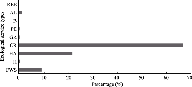
Xieet al., 2015). The unique natural characteristics and change process of glaciers determined by the service functions are obviously different from other ecosystems. The modeled and estimated value of the glacier ecosystem service can improve the understanding of the impact of glaciers on human welfare and maintenance of the ecological environment and will promote the research on regional ecosystems and even global ecosystem services.
Existing research on mountain glaciers is mainly focused on natural attributes of the processes and mechanisms such as morphology, distribution, ablation/accumulation, ice chemistry, and runoff replenishment (Guoet al., 2015; Wang et al., 2015; Shakunet al., 2015; Pieczonkaet al., 2015; Margoldet al., 2015; Duanet al., 2017). The research on ecological environment property and social attribute of glaciers is not deeply, especially for estimatesof service value of glaciers in regulating ecological environment and providing human welfare. (Xieet al., 2015; Xiao et al., 2016). Therefore, this article, guided by disciplinary theories such as glaciology and ecological economics, conducts research on Tianshan Mountain Glacier in China. Based on the analysis of the changing characteristics of the glacier area in the Tianshan Mountains in China from 1970 to 2010, the value of glacial ecological services provided by glaciers was evaluated by combining GIS spatial analysis techniques, unit area service function price method, and the equivalent factor method. This research will promote the ecological security of the cryosphere, environmental protection, and the sustainable use of resources.

2 Study area

The Tianshan Mountain Range is the largest independent zonal mountain system in the world and also the most distant mountain range from the ocean. This range has a length of 2500 km,and a width of 250-350 km with the maximum of more than 800 km, spanningfrom east to west four countries of China, Kazakhstan, Kyrgyzstan and Uzbekistan. Trending generally from east to west, Tianshan Mountains stretch to 1700 km in China (Tianshan, China for short), accounting for more than two-thirds of the length of the Tianshan Mountains (Figure 1) (Zhang et al., 2015). According to the First Chinese Glacier Inventory (FCGI), there are 9035 glaciers in the Tianshan Mountains, with a total area and an ice volume being 9225 km2 and 1011 km3, respectively. It is the cradle and water source of the Balkhash Lake, TarimRiver, JunggarBasin and Turpan-Hami Basin.
Figure 1 Location of the Tianshan Mountains, Northwest China

3 Research methods

Glacier change data in this article is taken from the First and Second Chinese Glacier Inventory (CGI) data and topographic maps of the Tianshan Mountains in China. Digital elevation model (DEM) is derived from Shuttle Radar Topography Mission (SRTM). The revision V4.1 with a horizontal resolution of 90 m is used in this study. The data are acquired from Chinese Academy of Sciences Computer Network Information Center International Scientific Data Mirroring Website (http://datamirror.csdb.cn).

3.1 Information extraction for glacier area change

According to the World Glacier Inventory (WGI), the FCGI dataset for the Tianshan Mountains was completed in 1987 by Lanzhou Institute of Glaciology and Geocryology of the Chinese Academy of Sciences. The data source was derived from topographic maps at scales of 1:50,000 and 1:100,000 using aerial photogrammetry techniques drawn during 1970-1980. However, limited by technological conditions, the precision of glacier boundary definition and area measurement accuracy were relatively low. To improve the accuracy, the aerial photographs adopted for the glacier inventory were collected. Combined with topographic maps, the glacier boundary contoursare systematically inspected and revised. By using GIS software to preprocess the scanned topographic maps, such as geometric rectification, the glacier boundary is vectored and the glacier parameters such as the glacier code and the name are recorded, so as to form the spatial and attributive FCGI vector dataset. The data sources adopted in the SCGI dataset were Landsat TM/ETM+ remote sensing images with little cloud and snow cover during June-September from 2008 to 2010.The data was freely downloaded from U.S. Geological Survey website (USGS, http://glovis.usgs.gov). The methods used in the SCGI dataset have been described in detail by Liu et al. (2015). For the SCGI dataset of Tianshan Mountains, experienced researchers manually revised the boundaries of automatically derived glaciers based on ENVI software. Although the SCGI dataset was created using visual interpretation that can be viewed as true glacier values, there were still some errors, such as the offset of the pixel. Accuracy of glacier information interpretation is controlled by the influence of sensor and image registration errors. For this reason, the uncertainty formula proposed by Hall et al. (2003) is used to calculate the glacier area error:
$\alpha =2\lambda \times \sqrt{{{\lambda }^{2}}+{{\varepsilon }^{2}}}$ (1)
where α is the area error; λ is the image resolution (spatial resolution is about 30m); ε is the registration error (Calculated on one pixel). The results showed that the area error of the per glacier is ±0.0021 km2. And the total area error of glaciers is ±88.20 km2, which occupied 1.12% of total glacier area in the SCGI datasets. The change of glacier reserves can indicate the contribution of glacial meltwater to river runoff. The formula for calculating the correlation between glacier area and glacier reserves is obtained (Sun et al., 2015).
$V=0.04{{S}^{1.35}}$ (2)
where V is the glacier reserves (km3); S is the glacier area (km2).

3.2 Ecological service functions and value estimation method of glaciers

Based on the Millennium Ecosystem Assessment Method (Xie et al., 2015), the ecological services of mountain glaciers were divided into four categories: Supply services, regulation services, support services and cultural services, and nine specific service functions were further subdivided (Table 1). Due to the diversity and complexity of the service function of the glacier ecosystem, a single evaluation method cannot be used to estimate. It is necessary to construct a reasonable mathematical model based on different service functions of the glacier ecosystem to estimate the service value. The direct use value of glaciers includes providing freshwater resource production value and non-competitive and non-excludable service value. The service value includes scientific research, environmental education, aesthetic appreciation, culture and art, and habitat services. The indirect use value of the glaciers is the benefit value obtained by the process of glacier changes or functions, which contains the value of regulating climate, regulating runoff, purifying environment and regulating the function of ecology. Among them, six functions, including supply of freshwater resources, hydroelectric power generation, hydrological regulation, climate regulation, aesthetic landscape, and scientific research and environmental education, are calculated by the unit-area functional price method. As the realization process of functions of the gas regulation, environment purification and biodiversity service of mountain glaciers are complex. It is difficult to objectively estimate the value by functional price method in the condition of basic experimental data absence. Therefore, this study uses the unit area equivalent factor method for these three functions.
Table 1 The value of all types of ecological service function of mountain glaciers in the Tianshan Mountains, Northwest China
Service function Service value (yuan/a) Percentage
(%)
First-class targets Second-class
targets
Unit-area
functional
price method
Functional price method
Supply service function Freshwater supply 5.6×10⁹ 2.4×10⁹ 9.30
Hydropower 3.5×10⁸ 0.58
Adjustment service
function
Hydrological adjustment 1.3×10¹⁰ 8.0×10⁹ 21.58
Climate regulation 4.0×10¹⁰ 6.1×10⁸ 66.40
Gas regulation 2.0×10⁸ 0.33
Purification environment 1.8×10⁸ 0.30
Support differentiated service functions Biodiversity 1.1×10⁷ 0.18
Culturalservice functions Aesthetic landscape 7.8×10⁸ 1.0×10⁸ 1.29
Scientific research and environmental education 1.9×10⁷ 0.03
Total 6.0×10¹⁰ 1.2×10¹⁰ 100
3.2.1 Unit service function price method
(1) Freshwater supply. Mountain glaciers provide abundant and high quality freshwater resources for human society. According to the average annual change in glacial reserves from 1970 to 2010, the economic value of the service of annual freshwater resources supplied for human social systems was calculated by using the direct market approach.
Vw = VG×Pw (3)
where Vw is the value of freshwater resources provided by glaciers (yuan); VG is the average annual change in glacier reserves (m3); Pw is the unit price of freshwater resources (yuan/m3). The water price is based on the integrated water supply price of 1.36 yuan/m3 in Urumqi City in 2010.
(2) Hydropower. Research shows that hydroelectric power generation is carried out in the Alps, the United States, and Norway with adequate ice and snow water sources and high altitudes (Che et al., 2004). In this paper, the potential value of hydroelectric power generation is calculated by shadow engineering method, and the annual glacial meltwater volume is converted into the total capacity of mountain reservoirs. Based on the seven typical mountain reservoirs in the Tianshan Mountains of China, the average annual power generation of the unit storage capacity is estimated, and the total annual power generation is finally converted into electricity expenses.
Vp = VG×E×Pw (4)
where Vp is the potential value of hydroelectric power generation provided by glacier meltwater (yuan); VG is the average annual variation of glacier reserves (m3); E is the unit storage capacity of generated energy (kw•h/m3), and the generated energy of average annual in the unit reservoir capacity of Tianshan Mountains in China is 0.37 kw•h/m3; Pw is the hydropower price (yuan/kw•h), and the hydropower price in this paper is replaced by the present grid purchase prices of small hydropower energy (0.235 yuan/kw•h) in Xinjiang.
(3) Hydrological adjustment. The “alpine solid reservoir” is sensitive to hydrothermal changes, and its accumulation/ablation process is accompanied by the conversion of substance and energy, which naturally regulates river runoff. The shadow engineering method is used to estimate the value of hydrological adjustment, and the average annual ice storage capacity is converted into the corresponding reservoir capacity, which is calculated in combination with the engineering cost required for the unit storage capacity.
Va = VG× Pr (5)
where Va is hydrological adjustment value of glacial volume change to river runoff (yuan); VG is the average annual variation of glaciers reserves (m3); Pr is the engineering cost (yuan/m3) of the unit storage capacity, and the cost of the unit storage capacity is 3.071 yuan/m3 (Xie et al., 2015).
(4) Climate regulation. Glacier as a special underlying surface with high albedo and the heat sink partial melting process has a certain degree of regulation of global and regional climate. Snow and ice albedo is the key factor affecting the melting, and it is also the key feedback factor for the close coupling of ice and climate. With the differences in climate and environment in different regions and changes in climate and environment, there is a great difference in surface albedo values such as dry snow, wet snow, snowfall, dry and clean glaciers, and hail and ice (Cai et al., 2005; Li et al., 2016). The phase transition process of glaciersfrom solid to liquid and gas consumes a lot of heat, which is actually a certain inhibitory effect on the increase of temperature. The process mainly includes the energy conversion of melting, evaporation and sublimation and sensible heat, and the energy balance of the ice surface is obviously different with the change of season and altitude. The value of climate regulation is estimated by direct market method. To facilitate the research, the sum of reflected solar radiation on the surface of the glaciers and the absorbed thermal energy is taken as the contribution of the glaciers to the suppression of global warming, and the thermal energy is converted into equivalent electrical energy. The annual service value of climate regulation is calculated by electricity price.
Vc = (SG×R ×αa×αs + VG×pG×qG) ×Pe (6)
where Vc is the value of glacier climate adjustment (yuan); SG is the total area of the glacier for SCGI; VG is the average annual variation of glacier reserves (m3); the parameters involved in the formula are all from related references. The annual solar radiation (R) in the Tianshan Mountains of China is 5000 MJ/m2·a; snow and ice albedo (αa) is 0.6; terrain shading rate (αs) is 0.5; glacier density (pG) is 0.9 g/cm3; specific heat capacity of glacier melting (qG) is 336,000 J/kg; Pe is the electricity price (yuan/ kw•h), referring to the average price of electricity in various industries in Urumqi in 2010 of 0.515 yuan/ kw•h.
(5) Aesthetic landscape. The rolling snow ridges of the Tianshan Mountains and the icy peaks of the mountains form a unique landscape, attracting a large number of Chinese and foreign tourists. The love, awe and praise of the people of all nationalities are entrusted by the glaciers and the snow-cappedmountains, which provide creative inspiration and rich themes for ethnic songs, paintings, and literary creation such as poetry and fiction. In addition, religious personages have given the iceberg a certain amount of connotation, so it also has unique cultural and artistic value. The aesthetic value of the glaciers was estimated by questionnaires combined with the travel cost method. In the study, 500 questionnaires were mailed out to the local and foreign tourists and 482 valid questionnaires were collected. Based on this point, the proportion of the total travel cost of tourists for the purpose of glacier-related tourism is calculated, combined with the total annual tourism revenue in Xinjiang to estimate the value of aesthetic landscape provided by glaciers.
Vt = T×Rg (7)
where Vt is the aesthetic landscape and cultural value provided by the glacier (yuan); T is the total annual income of local tourism in the study area (yuan); Rg is the percentage of glacial-related tourism (%); the total tourism revenue of Xinjiang was 6.54×10¹⁰ yuan in 2010.
(6) Scientific research and environmental education. Glaciers are unique media and objects for the study of climate and environmental changes, and are often used as natural archives for the study of pollution history. The value of this service type is reflected in the annual amount of research funds provided by the national and local governments for the glacier related research in the Tianshan Mountains.
Vs = St (8)
where Vs is the value of scientific research and environmental education provided by glaciers (yuan); St is the scientific research funding provided by the national and local for research projects of glaciers in the study area (in yuan). In order to simplify the statistics, this article uses the total funding of 1.87 × 10⁷ yuan of the National Natural Science Foundation projects approved in 2010 as reference data.
3.2.2 Unit area value equivalent factor method
According to the equivalent weight factor of the value of services of Chinese terrestrial ecosystem proposed by Xie et al. (2015), and referring to the economic value of food production per hectare supplied by cropland ecosystem in Xinjiang from 2005 to 2014 (Mansur et al., 2016), we determined the equivalent of the above four ecological service functions of glaciers in the Tianshan Mountains in China by referringto the unit prices of ecological services provided by farmland, and the value of various types of glacial ecological services is finally estimated (Table 1).

4 Result and analysis

4.1 The variation characteristics of glacier area

According to the FCGI and SCGI, there were 9035 glaciers with an area of 9225 km2 and ice volume of 1011 km3 in the Tianshan Mountains during the period 1970-1980; and the glaciers covering an area of 7884 km2have an ice volume of 728.9 km3 from 2008 to 2010. The area and volume of glaciers decreased by 1274 km2 and 4.08×10⁹ m3, respectively and the surface of the glaciers has retreated by 13.9%. As shown in Figure 2, the position of glacial end has subsided from 2200 m to 2800 m in the past 40 years. And the area of glaciers at the elevation of 3800-4800 m accounts for more than 80% of the total area. The glacier changes below 3600 m are most sensitive, with area reductions accounting for 52.8% of the total change, while glacier area with elevations above 5200 m increases by 8.95%. As shown in Figure 3, the north and south directions are distributed with an absolute number of glaciers,covering more than 81% of the total, of which the northeastern glacier area is the largest, and the western area is the smallest. The glaciers retreat from the southern area is more obvious, which is over 44.4%.
Figure 2 Changesof glacier area in different altitude ranges in the Tianshan Mountains, Northwest China
Figure 3 Orientational characteristics of glacial changes in the Tianshan Mountains, Northwest China
Comparing with other relevant research results, we found that the annual change rate of glaciers (-0.35%/a) in this paper is close to the statistical analysis of the variation rate of about 3000 glacier areas (-0.31%/a) of the Tianshan Mountains in China in the last 50 years (Wang et al., 2011), slightly lower than the calculation (Sun et al., 2015) of the glacier area change rate (-0.4%/a) in Qilian Mountain based on the data of FCGI and SCGI dataset. This may be due to the fact that the scale of the glaciers in the Tianshan Mountains is much larger than that of the Qilian Mountains, and that small area or small-scale glaciers are more sensitive to the increase in temperature. The retreat of glaciers on south-facing slopes is more dramatic than that on the other, due to the fact that the southern side has acquired more solar radiation as a sunny slope. The glacier area has increased at high altitudes (>5200 m). Glacier development depends on the composite action between temperature and precipitation in the mountainous areas. It was shown that the climate of the northwest region presenteda trend of warming and moistening under the background of global climatic change, leading to glacier accumulation caused by increasing precipitation in this area, which is greater than glacier ablation caused by rising temperatures.

4.2 Analysis of glacier ecosystem service value

Based on the annual average amount of ice volume in the Tianshan Mountains from 1970 to 2010 and the glacier areas in 2008-2010, the functional price method and the equivalent weight factor method were used to estimate the annual value of eco-economy service provided by glaciers (Table 1). Statistics show that the annual ecological service value provided by glaciers in the Tianshan Mountains in China amounted to 56 billion yuan, ranking according to the level of service function value, followed by climate adjustment > hydrological adjustment > water supply > aesthetic landscape > hydropower > gas regulation > purification environment > research and environmental education> biodiversity. Among them, the value of climate inhibition caused by glacier surface albedo and melting decalescence accounted for 66.40% of the total value, and the value of river runoff regulation and freshwater resource supply accounted for 21.58% and 9.30% of the total value, respectively (Figure 4). The conclusion may be further explained that the glaciers in high and cold areas have a very significant inhibitory effect on climate warming. Glacial meltwater plays an important role in the stability of runoff replenishment in arid regions, industrial and agricultural production in oasis region, and ecological development. However, the value of the environment purification, gas exchange, biodiversity, scientific research and education of the Tianshan Glaciers in China is usually ignored or underestimated. It is estimated that its annual ecological service value can reach1.28 billion yuan, which makes people more intuitively aware of the important ecological status of glacial protection. The former relevant research seldom involved the functions of glacier hydroelectric power generation services, but this study found that the annual average ecological service value of glacier meltwater using the comparatively great undulation of the landforms for hydroelectric power generation is about 350 million yuan. On the whole, in the context of global warming, mountain glaciers contribute much to the suppression of regional and global temperature rises. The realization mechanism of this service function may have important implications for global climate change research. Glacial meltwater, as an important and fairly stable component of river runoff recharge in arid regions, cannot be ignored.
Figure 4 Percentage of the value of all types of ecological services in the Tianshan Mountains, Northwest China
(FWS is freshwater supply, H is hydropower, HA is hydrological adjustment, CR is climate regulation, GR is gas regulation, PE is purification environment, B is biodiversity, AL is aesthetic landscape, and REE is scientific research and environmental education.)
This article uses two methods to estimate the value of water supply, hydrological regulation, climate regulation and aesthetic landscape. The results showed that the value by the equivalent factor method is lower than thatby the functional price method, totaling about 43.5 billion yuan. Just as some scholars believe, many ecosystem service values are underestimated (Xie et al., 2015). The ecological service function of glaciers is mainly achieved by the conversion of material and energy in the process of strong albedo and glacier ablation / accumulation. In previous studies, the equivalent weight factor of the ecological services value provided by per unit glacier area was derived from the expert experience method, which inevitably led to bias in objectively estimating the ecological service value. The above glacial ecological service functions simply rely on static description and subjective quantification, and obviously lack the analysis of their changing mechanisms. Under the drivers of climate warming and human interference, the scarcity of glacier services has been increasing, and its ecological and socio-economic functions have shown an enhanced and weakened trend (Xiao et al., 2016). In addition, the accumulation/ablation of glaciers has obvious difference in time (dry/rainy seasons) and space (elevation, aspect, etc.), which makes the ecological service function also have some dynamic characteristics. If the experiments of glacial meteorological and ice chemistry are combined with 3S technology (RS, GIS and GPS), the dynamic and spatial heterogeneity of the ecological service function of glaciers can be well depicted.

5 Discussion

To compare the similarities and differences of mountain glacial ecosystem services and the three major terrestrial ecosystems in forest (Li et al., 2016), grassland (Ye et al., 2006; Sun et al., 2011) and wetland (Sun et al., 2008; Xie et al., 2011; Tian et al., 2015), this article specifically collects literatures about the estimate of value of terrestrial ecosystem service based on the ecological function price method in Xinjiang in recent years (Table 2). Although ecosystem types and service functions are different in various documents, and the comparative studies on the service function contribution rates are limited, they can still provide an important basis for the evaluation of the relative contribution degree, and a theoretical support for the optimization of the index system and the allocation of service functions. From a comparative analysis of the glaciers, forest, grassland and wetland ecosystems, the supply of freshwater resources/physical production and ecological regulation represent the main contributions of the four types of system, which account for 94.12%, 69.57%, 44.57% and 88.42%, respectively. In the forest and wetland ecosystems, the hydrological regulation/water conservation is the most valuable service function, and the purification environment/waste treatment is the greatest contribution in the grassland system. The biodiversity/habitat function provided by glaciers is much lower than that of other types of ecosystem. According to the principles of simplification and operability, in order to enhance the comparability of the service value of glaciers, forest, grassland and wetland per unit area, the original value of the other ecosystem services is converted to the economic value of 2010 by using the CPI index of different years. Compared with the ecological service value of ecological system per unit area, the service value of glacier per unit area in Tianshan Mountains (76 thousand yuan/ha·a) is the highest. The service value of ecosystems per unit area in wetland (Albea Lake, Boston Lake, Kekesu River) and forest (mountain forests in Xinjiang) show little difference, which are 40.5 thousand yuan/ha·a and 35.5 thousand yuan/ha·a respectively. Grassland (Xinjiang grassland, Yili river valley grassland) unit area ecologicalservice value (8 thousand yuan/ha·a) is the lowest. Compared with other ecosystems, the mountain glacier resources have complete ecological service functions, and the function values of climate change inhibition and river runoff regulation are more valuable than those of other ecosystems. It is further confirmed that glaciers and meltwater have great influence on regional ecological environment security, industrial and agricultural development and social economy.
Table 2 The economic value of different types of ecosystem services
Ecological service types of glacier Percentage of service values (%)
Glacier Forest Grassland Wetland
Freshwater supply or production of goods 17.3 1.48 4.82-21.26 0.99-18.86
Hydropower 1.07 - - -
Hydrological adjustment or water conservation 23.4 44.16 11-13.54 32.79-82.92
Climate regulation 56.1 - 12.39 -
Gas regulation or carbon fixation and oxygen release 0.32 23.93 2.75-11 4.11-35.08
Purification environment or waste treatment 0.35 5.01 14.75-18.02 0.02-12.06
Biodiversity or habitats 0.02 20.38 8.61-15.00 0.63-37.03
Aesthetic landscape or recreational entertainment 1.4 - 0.55-2.55 0.58-0.91
Scientific research and environmental education
or cultural value
0.03 - 2.90 7.54-9.13
The terrestrial ecosystem can directly provide freshwater, food, and raw materials needed by human society, and it can also improve the ecological environment in the process of system material and energy conversion,coordinate human interference with the environment and counteract global climate change by conserving water sources, and regulating climate and gas exchange. The value of several ecological services (gas regulation, purification environment and biodiversity) provided by glaciers was estimated by the equivalent factor method in this paper, which is lower than that of other terrestrial ecosystems. On the one hand, this phenomenonis caused by the inherent differences in the service functions of different ecosystems, while on the other, it may be due to the distribution of the weights of various service functions in the quantitative factor method. The value of scientific research and cultural services of the ecosystem is obviously irreplaceable, and it is also the most basic test site for the study of various types of ecological service function. The realization of the ecological service function of terrestrial ecosystems is a complex process, which depends on the ecological foundations such as the composition of the ecological system structure and the mechanism of the material energy transformation. The greater potential service value and more service function of the ecosystem can be further explored by studying the relationship between the structure, ecological processes and service functions of each system.

6 Conclusions and prospect

(1) According to the statistics of the FCGI and SCGI dataset, the area and ice volume of glaciers in the Tianshan Mountains decreased by 1274 km2 (the ratio of area shrinking was 13.9%) and 4.08×10⁹ m3 from 1956 to 2010, respectively. The increase in glacier area at high altitudes (> 5200 m) may be due to glacier accumulation caused by increasing precipitation is greater than glacier melting caused by rising temperatures.
(2) This study modeled the ecosystem service function of mountain glaciers and used the service value per unit area and equivalent factor methods to determine the annual value of the ecological service provided by glaciers in the Tianshan Mountains in China. The annual value of the ecological service provided by glaciers in the study area is 60.2 billion yuan. The values of climate regulation, hydrological regulation, and freshwater resource supply account for 66.4%, 21.6%, and 9.3% of the total value, respectively. The annual average ecological service value of hydropower is approximately 350 million yuan, and the other types of regulation and service function value are about 1.28 billion yuan.
(3) From a comparative analysis of the glaciers, forest, grassland and wetland ecosystems, the supply of freshwater resources/physical production and ecological regulation represent the main contributions of the four types of system, which account for 94.12%, 69.57%, 44.57% and 88.42%, respectively. In the forest and wetland ecosystems, the hydrological regulation/water conservation is the most valuable service function, and the purification environment/waste treatment makes the greatest contribution in the grassland system. The biodiversity/habitat function provided by glaciers is much lower than that of other types of ecosystem.
For about half a century, many scholars have made fruitful achievement in the fields of glacier physics, glacier fluctuations responding to climate change, mechanisms and simulations in glaciology, ice formation processes and climatic and environmental records, glacier hydrology and meteorology, quaternary glacial landforms and periglacial geomorphology, altifrigetic subnival vegetation and eco-environment in arid area. This provides an important scientific basis for the regional water resources management and efficient utilization and sustainable development policy planning in China. However, studies on the functions of glacier ecosystem services and of the economic value assessment are rarely involved. This is a shortcoming in academic research. And under the global warming and the fast retreat of glaciers, it is also extremely unfavorable for us to manage glacier water resources and understand the influence of glaciers on regional and global ecological balance.

The authors have declared that no competing interests exist.

[1]
Aizen V B, Aizen E M,Melack, J M, 1995. Climate, snoe cover, glaciers, and runoff in the Tienshan, Central Asia.Water Resources Bulletin, 31(6): 1113-1129.ABSTRACT: The Pica Shan, a mountainous region located on the northern periphery of central Asia, has a wide range of climatic and hydrological conditions. On the basis of long term data from 348 meteorological and glaciological stations, the annual distribution of precipitation in different regions and elevational zones of the Tien Shan was calculated. Major climatic features are the entrance of moisture during spring-summer, small winter precipitation, decrease of precipitation towards the east and the center of the mountains or with distance up valleys, and increase of precipitation with altitude up to crest-lines of ranges. Annual total evaporation from snow can be 5009000960 mm per year, reaching 30 percent of snow accumulation.

DOI

[2]
Cai F, Zhu Q L, He H L et al., 2005. Estimation and spatio-temporal distribution of monthly mean surface albedo in China.Resources Science, 27(1): 114-120. (in Chinese)

[3]
Che T, Jin R, Li X et al., 2004. Glacial lakes variation and the potentially dangerous glacial lakes in the Pumqu Basin of Tibet during the last two decades.Journal of Glaciology and Geocryology, 26(4): 397-402. (in Chinese)Along with glacier retreating due to global warming, more and more meltwater cumulates in glacial lakes, resulting in expansion of lake surface. Rapid accumulation of water in glacial lakes, particularly in those lakes adjacent to retreating glaciers, can lead to a sudden outburst of the unstable dams in front of the lakes. The glacial lake outburst flood (GLOF) often has catastrophic effect on downstream regions. The GLOF causes many dangers to local people, as well as to houses, bridges, fields, forests and roads. The lakes at risk are situated in remote and inaccessible areas. Remote sensing provides a feasible method to monitor these glacial lakes. Satellite images (ASTER) acquired in 2000/2001 were interpreted and compared with the report of the First Expedition to Glaciers and Glacier lakes in the Pumqu and Poiqu River Basins, Xizang (Tibet), China. The final results have shown that there are 225 glacial lakes with a total area of 1,062 km+2, and there are 24 glacial lakes were identified as the potentially dangerous lakes in the Pumqu basin. It provides the basic information for GLOF mitigation measures, as well as for their monitoring and establishing an early warning system.

DOI

[4]
Duan K Q, Yao T D, Shi P H et al., 2017. Simulation and prediction of equilibrium line altitude of glaciers in the eastern Tibetan Plateau.Scientia Sinica Terrage, 47(1): 104-113. (in Chinese)冰川变化数值模拟及预测是全球变化的前沿领域,冰川平衡线高度(ELA)作为对气候状态的直接响应,其变化直接体现冰川的扩张和消融.本文基于能量物质平衡方程,由气象观测为输入数据,模拟了青藏高原东部冰川ELA的空间分布,模拟结果显示自1970年以来,高原东部冰川ELA以2~8m/a的速率升高,高原边缘,特别是在祁连山和藏东南,部分冰川的ELA已经达到或超过了冰川顶部,意味着该地冰川处在消亡边缘.为预测ELA的变化趋势,以唐古拉山小冬克玛底冰川和祁连山七一冰川为例,采用IPCC给出的低、中、高三种碳排放路径下21世纪的气候变化情景,发现在采取大力减排措施的RCP2.6情景下,两冰川ELA都在2040年左右达到最大值且接近冰川顶部,冰川积累区大幅度缩小.在RCP4.5中排放路径下,两冰川ELA将在2045年左右超过冰川顶部,冰川积累区消失,冰川将强烈消融直至消亡.在RCP8.5高排放路径下,两冰川ELA将在2035年左右超过冰川顶部,冰川积累区消失,冰川将急剧消融直至消亡.从物质能量平衡角度证明在当前全球变暖背景下,不论在何种情景下,高原东部山地冰川将加剧退缩乃至消亡.

[5]
Hall D K, Bayr K J, Schner W et al., 2003. Consideration of the errors inherent in mapping historical glacier positions in Austria from ground and space (1893-2001).Remote Sensing of Environment, 86(4): 566-577.The historical record of in situ measurements of the terminus positions of the Pasterze and Kleines Flei08kees glaciers in the eastern Alps of Austria is used to assess uncertainties in the measurement of decadal scale changes using satellite data. Topographic maps beginning in 1893, and satellite data from 1976 to 2001, were studied in concert with ground measurements to measure glacier changes. Ground measurements show that the tongue of the Pasterze Glacier receded 651150 m from 1893 to 2001, while satellite-derived measurements, using August 2001 Landsat Enhanced Thematic Mapper Plus (ETM+) data registered to an 1893 topographic map, show a recession of 1300–1800 m, with an unknown error. The measurement accuracy depends on the registration technique and the pixel resolution of the sensor when two satellite images are used. When using topographic maps, an additional source of error is the accuracy of the glacier position shown on the map. Between 1976 and 2001, Landsat-derived measurements show a recession of the terminus of the Pasterze Glacier of 479±136 m (at an average rate of 19.1 m a 611) while measurements from the ground showed a recession of 428 m (at an average rate of 17.1 m a 611). Four-meter resolution Ikonos satellite images from 2000 and 2001 reveal a shrinkage of 22,096±46 m 2 in the Pasterze tongue. The nearby Kleines Flei08kees glacier lost 30% of its area between 1984 and 2001, and the area of exposed ice increased by 0.44±0.0023 km 2, according to Landsat satellite measurements. As more recent satellite images are utilized, especially data that are geocoded, the uncertainty associated with measuring glacier changes has decreased. It is not possible to assess the uncertainty when an old topographic map and a satellite image are coregistered.

DOI

[6]
Guo W, Liu S, Xu L et al., 2015. The second Chinese glacier inventory: Data, methods and results. Journal of Glaciology, 61(226): 357-372.The second Chinese glacier inventory was compiled based on 218 Landsat TM/ETM+ scenes acquired mainly during 2006-10. The widely used band ratio segmentation method was applied as the first step in delineating glacier outlines, and then intensive manual improvements were performed. The Shuttle Radar Topography Mission digital elevation model was used to derive altitudinal attributes of glaciers. The boundaries of some glaciers measured by real-time kinematic differential GPS or digitized from high-resolution images were used as references to validate the accuracy of the methods used to delineate glaciers, which resulted in positioning errors of +/- 10 m for manually improved clean-ice outlines and +/- 30 m for manually digitized outlines of debris-covered parts. The glacier area error of the compiled inventory, evaluated using these two positioning accuracies, was +/- 3.2%. The compiled parts of the new inventory have a total area of 43 087 km(2), in which 1723 glaciers were covered by debris, with a total debris-covered area of 1494 km(2). The area of uncompiled glaciers from the digitized first Chinese glacier inventory is similar to 8753 km(2), mainly distributed in the southeastern Tibetan Plateau, where no images of acceptable quality for glacier outline delineation can be found during 2006-10.

DOI

[7]
Li J M, Zhang Y T, Bai Z Q et al., 2016. Assessment of service functions value of mountain forest ecosystem in Xinjiang Province, China.Journal of Southwest Forestry University, 36(4): 97-102. (in Chinese)According to the "Forest Ecosystem Services Assessment Standards "( LY /1721- 2008),and based on the data from the eighth national forest resource inventory of Xinjiang Province,long-term monitoring data by Xinjiang Tianshan forest ecosystem research station and Aletai Mountain forest ecosystem research station and public data,the service function total values of 14 major dominant trees,two stand types and five arbor age groups in Mountain forest ecosystem in Xinjiang Province were evaluated. The results showed that the total value of the service functions of mountain forest ecosystem was 862. 46 × 108 yuan / a; The value order of individual service function was water conservation carbon fixation and oxygen released species conservation soil conservation atmosphere environmenta1 purification nutrient accumulation. The ecosystem service value of arbor and shrub occupied 69. 27% and 30. 72% of the total value,respectively; The ecosystem service value of Tianshan and Aletai mountain occupied 57. 34% and 42. 46% of total value,respectively; The total value order of five age group was mature forest over-mature forest near-mature forest middle age forest sapling forest. The value of per unit area ecosystem service was 3. 59 × 104 yuan /( hm~2·a),of which arbor and shrub was 5. 09 × 104 yuan /( hm~2·a)and 2. 01 × 104 yuan /( hm~2·a); Tianshan and Aletai mountain forest was 3. 30 × 104 yuan /( hm~2·a) and 3. 77 ×104yuan /( hm~2·a); The value order of per unit area ecosystem service of five age groups was over-mature forest middle age forest mature forest sapling forest near-mature forest.

[8]
Li Q L, Wang N L, Wu X B et al., 2010. Sources and distribution of polycyclic aromatic hydrocarbons of different glaciers over the Tibetan Plateau.Science China: Earth China, 40(10): 1399-1409. (in Chinese)http://link.springer.com/article/10.1007%2Fs11430-010-4047-3

DOI

[9]
Li Y H, Zan L Y, Chen L Q, 2014. Advances in the study of methane in the Arctic Ocean.Advances in Earth Science, 29(12): 1355-1361. (in Chinese)

[10]
Li Z Q, Han T D, Jin Z F et al., 2003. Summary of 40-year observed variation facts of climate and Glacier No.1 at headwater of Urumqi River, Tianshan, China.Journal of Glaciology and Geocryology, 25(2): 117-123. (in Chinese)Comprehensive, Glacier No.1 centered o bservations are conducted at headwater of rümqi River by Tianshan Glaciological Station since 1959.This paper presents analyses of mass balance, terminus, area and surface velocity histories of Glacier No.1, and as well as spatial distributed streamflow and climate factor (air temperature and precipitation) records from nearby area. Our study demonstrates that the continuous local annual temperature rising, resulting in reduction of cooling energy in the glacier, might be responsible for recent acceleration of glacier melting. The headwater region of rümqi River is experiencing a warm and humid period ever sine the mid-90s. From 1958 to 2000, with an average annual balance -188.6 mm (about -34.6×10 4 m 3 in volume), the cumulative balance of Glacier No.1 is reach u p to -7 925 mm(1 452×10 4 m 3 ), in other words, the thickness of the glacier stream decreased by more than 8m over the past 42 year span. With an accelerated shrinking tendency, the glacier area decreased by 11% from 1962 to 2001. The terminus of the glacier is in the state of retreat since it has been observed from 1960s. From 1962 to 2001 East Branch retreated 168.95 m, whilst West Branch retreated 185.23 m. In agreement with ice mass losing, surface velocity of the glacier is appreciably slowing down. By using water balance model, annual meltwater runoff of the glacier has been computed sine 1958. It shows an elevated trend, especially after 1985. The mean meltwater runoff depth from 1986-2001 is 936.6 mm, comparing to 508.4 mm from 1958 to 1985, it increased by 84.2%.

[11]
Liu S Y, Yao X J, Guo W Q et al., 2015. The contemporary glaciers in China based on the Second Chinese Glacier Inventory.Acta Geographica Sinica, 71(1): 3-16. (in Chinese)The Second Chinese Glacier Inventory(SCGI) was compiled based on remote sensing images after 2004 including Landsat TM/ETM + and ASTER images,and the digital elevation models(DEMs) from SRTM.The SCGI shows that there are 48,571 glaciers with a total area of 5.18 104km2and ice volume of 4.3 103-4.7 103km3in China(including glaciers measured from 1:50,000 or 1:100,000 topographic maps made from the 1960 s to the 1980 s because of no high quality remote sensing images for the contemporary glacier inventories).The number of glaciers with the area below 0.5 km2 reaches 33,061 and accounts for the majority part(66.07%) of glaciers in China.Glaciers with areas between 1.0 km2 and 50.0 km2 are totaled as ~3.40 104km2(~2.65 103km3 in ice volume) and constitute the main part of glaciers in China.The Yengisogat Glacier(359.05 km2),located in the Shaksgam Valley,north slope of the Karakoram Mountain,is the largest glacier in China.The glaciers are spatially distributed in 14 mountains and plateaus in western China.The Kunlun Mountains has the largest number of glaciers in China,followed by Tianshan Mountains,Nyainq ntanglha Range,the Himalayas and Karakoram.Glaciers in the above five mountains account for 72.26% of the total glacier number in China,however,over 55% of the total area of glaciers and 59% of the total ice storage in China are concentrated in the Kunlun Mountains,Nyainq ntanglha Range and Tianshan Mountains.The number and area of glaciers in Karakoram Mountains are less than those in the Himalayas,but the volume of the former is more than that of the latter because the glaciers in the Karakoram are generally larger.Some 4/5 of the total area of glaciers in China is mainly distributed in an altitudinal band between 4500-6500 m a.s.l.with regional differences depending on the general elevations of various mountains.Analogously,there is an obvious difference of glaciers in basins.The first level basin having the most glaciers is the East Asia interior drainage area(5Y) which occupies ~40% of glaciers in China.The Yellow River basin(5J) has the fewest glaciers where only 164 with an area of 126.72 km2 are distributed.Xinjiang and Xizang autonomous regions are the two provincial units rich in glaciers,with ~9/10 of the total area and ice storage of glaciers in China.

[12]
Mansur S, Nasima N, Arslan M, 2016. Analysis on the change of land uses/cover ecological service value in Tomur National Nature Reserve.Geographical Research, 35(11): 2116-2124. (in Chinese)Based on three periods of remote sensing image data, August in 1989, 2002 and2014, by using the Costanza ecosystem service value calculation formula, and referring to the Chinese terrestrial ecosystem service value equivalent, the paper, combined with biomass and biodiversity of different land use/cover types in the study area, formulated ecosystem service function value equivalent weight of each land use/cover types in Tomur National Nature Reserve, and analyzed changes in the value of ecosystem service of different land use/cover types. Results showed that:(1) Glacial snow was the largest land type in the reserve,accounting for 49.18% of the total area, and increased by 3.66 10~4hm~2 during 1989-2014, with an annual rate of 1.11%; Grassland area, which accounted for 3.72%, increased by 0.34 10~4hm~2, with an annual rate of 1.43%; Water area, accounting for 3.81%, had a reduction of1.63 10~4hm~2, with an annual rate of 2.22%; Waste land, accounting for 42.31%, decreased by2.33 10~4hm~2, with an annual rate of 0.55%; Woodland, accounting for 0.98%, with an annual rate of 1.70% in early stage and 1.33% in later stage. The dynamics of water, grassland and forest land was high, while that of glacier and wasteland was low. The overall dynamic degree of the region in the early stage was 0.72% and the later stage was 0.62%, suggesting that with the promotion of the reserve to the national level in 2003, enhancement of protection efforts and weakening of the impact of human activities, the active degree of mutual conversion between different types gradually slowed down.(2) The ecological service value of the reserve was 52.31 10~8yuan/a, which highlighted the important ecological status of the protected area.The ecological service function of water resource supplies and hydrological regulation was the highest in the 11 ecological service functions of the reserve, which was related to the large area of glacier and water in the protected area. The value of the ecological service function of food and raw material production was low, which was related to its non-productive operation mode.During the study period, the total value of ecosystem services decreased by 31.49%, while that of grassland and glaciers increased by 35.70% and 27.63%, and the water and wasteland decreased by 55.43% and 13.81%, and the forest land decreased by 22.13% first and then increased by 15.75%. In the proportion of the value, water was dominant in 1989, and the glacier was in 2014. The main reason was that the water body with the high value of the ecological service was replaced by the glacier with the lower value of the ecological services.

DOI

[13]
Margold M, Stokes C R, Clark C D, 2015. Ice streams in the Laurentide Ice Sheet: Identification, characteristics and comparison to modern ice sheets.Earth-Science Reviews, 143: 117-146.This paper presents a comprehensive review and synthesis of ice streams in the Laurentide Ice Sheet (LIS) based on a new mapping inventory that includes previously hypothesised ice streams and includes a concerted effort to search for others from across the entire ice sheet bed. The inventory includes 117 ice streams, which have been identified based on a variety of evidence including their bedform imprint, large-scale geomorphology/topography, till properties, and ice rafted debris in ocean sediment records. Despite uncertainty in identifying ice streams in hard bedrock areas, it is unlikely that any major ice streams have been missed. During the Last Glacial Maximum, Laurentide ice streams formed a drainage pattern that bears close resemblance to the present day velocity patterns in modern ice sheets. Large ice streams had extensive onset zones and were fed by multiple tributaries and, where ice drained through regions of high relief, the spacing of ice streams shows a degree of spatial self-organisation which has hitherto not been recognised. Topography exerted a primary control on the location of ice streams, but there were large areas along the western and southern margin of the ice sheet where the bed was composed of weaker sedimentary bedrock, and where networks of ice streams switched direction repeatedly and probably over short time scales. As the ice sheet retreated onto its low relief interior, several ice streams show no correspondence with topography or underlying geology, perhaps facilitated by localised build-up of pressurised subglacial meltwater. They differed from most other ice stream tracks in having much lower length-to-width ratios and have no modern analogues. There have been very few attempts to date the initiation and cessation of ice streams, but it is clear that ice streams switched on and off during deglaciation, rather than maintaining the same trajectory as the ice margin retreated. We provide a first order estimate of changes in ice stream activity during deglaciation and show that around 30% of the margin was drained by ice streams at the LGM (similar to that for present day Antarctic ice sheets), but this decreases to 15% and 12% at 12calka BP and 10calka BP, respectively. The extent to which these changes in the ice stream drainage network represent a simple and predictable readjustment to a changing mass balance driven by climate, or internal ice dynamical feedbacks unrelated to climate (or both) is largely unknown and represents a key area for future work to address.

DOI

[14]
Pieczonka T, Bolch T, 2015. Region-wide glacier mass budgets and area changes for the Central Tien Shan between similar to 1975 and 1999 using Hexagon KH-9 imagery.Global and Planetary Change, 128: 1-13.61Geodetic mass budgets have been determined for a glacierized area of 5000km2.61Between ~1975 and 1999 the overall glacier mass budget was 610.35±0.34mw.e.a611.61The glacier area shrank by 0.11±0.14%a611in the ~1975–2008 period.61Glacier area change was comparatively low, whereas glacier mass loss was high.61The glacial contribution to annual runoff was ~20%.

DOI

[15]
Shangguan D H, Liu S Y, Ding Y J et al., 2009. Glacier changes during the last forty years in the Tarim Interior River basin, Northwest China.Progress in Natural Science, 19(6): 727-732.By comparing digitized glacier outlines from the Chinese Glacier Inventory (CGI) during the 1960s–1970s and Landsat Enhance Thematic Mapper (ETM) images from 1999 to 2001, we investigated changes for about 7665 alpine glaciers among 11665 glaciers in seven sub-basins of the Tarim Interior River basin (TIRB). The results showed that the total glacier area was reduced by 3.3% from the 1960s/1970s to 1999/2001 and area losses for 1–502km glaciers accounted for 48.3% of the total glacier area loss in the TIRB. However, the glacier area reductions varied from 0.7% to 7.9% among the seven sub-basins of the TIRB during the study period. The glacier area changing with altitude showed that the maximum contribution of area shrinkage occurred at 4900–540002m. Data from 25 meteorological stations in the TIRB showed increases in both the annual mean air temperature and annual precipitation during 1960–2000. This indicates that the glacier shrinkage in the TIRB over the last 4002years was largely due to regional climate warming that enhanced glacier ablation and overcame the effects of increased precipitation on the glacier mass balance.

DOI

[16]
Shakun J D, Lea D W, Lisiecki L E et al., 2015. An 800-kyr record of global surface ocean delta O-18 and implications for ice volume-temperature coupling.Earth and Planetary Science Letters, 426: 58-68.

DOI

[17]
Shi Y F, Liu S Y, 2000. Estimation on the response of glaciers in China to the global warming in the 21st century.Chinese Science Bulletin, 45(7): 668-672.Glaciers in China can be categorized into 3 types, i.e. the maritime (temperate) type, sub-continental (sub-polar) type and extreme Continental (polar) type, which take 22%, 46% and 32% of the total existing glacier area (59 406 km2) respectively. Researches indicate that glaciers of the three types show different response patterns to the global warming. Since the Maxima of the Little Ice Age (the 17th century), air temperature has risen at a magnitude of 1.3 n average and the glacier area decreased corresponds to 20% of the present total glacier area in western China. it is estimated that air temperature rise in the 2030s, 2070s and 2100s will be of the order of 0.4-1.2, 1.2-2.7 and 2.1-4.0 K in western China. With these scenarios, glaciers in China will suffer from further shrinkage by 12%, 28% and 45% by the 2030s, 2070s and 2100s. The uncertainties may account for 30%-67% in 2100 in China.

DOI

[18]
Stavi I, Bel G, Zaady E, 2016. Soil functions and ecosystem services in conventional, conservation, and integrated agricultural systems: A review.Agronomy for Sustainable Development, 36(2): 1-12.AbstractFarming activities in the Argentinean Pampa have focused on soybean production since the 1990s. The resulting cropping systems may not be sustainable in the long run due to development of glyphosate-tolerant weeds, homogenization of landscape mosaics, and pollutions. Here, we used the tracking on-farm innovation method to produce resources for the design of alternatives. The five steps of tracking on-farm innovation were (1) characterization of the soybean-based dominant cropping system, (2) identification of producers developing alternative systems, (3) description of these cropping systems and their agronomic logic, which is the link between the producer practices and their motives when choosing these practices, (4) multicriteria assessment of the performances of the systems, and (5) analysis of the development conditions of the most efficient systems. We identified 22 alternative cropping systems developed by farmers. These systems all include original practices: diversification of crop rotations (22 cases), occasional return to tillage (15 cases), and low pesticide use (16 cases). Some alternative systems were more sustainable than the soybean-based system, as shown by lower economic risk level, better ability to maintain soil organic carbon content, and less glyphosate-tolerant weeds. Our results show overall that tracking on-farm innovations is an efficient method to get references on alternative cropping systems developed by farmers.

DOI

[19]
Song C, 2016. Spatial assessment of ecosystem functions and services for air purification of forests in South Korea.Environmental Science & Policy, 63: 27-34.Ecosystem functions can be understood as the quantified amount of an ecosystem role in a natural process, while ecosystem services are the requantification of the ecosystem functions by factoring in environmental conditions and human needs based on social perspectives. In this study, differences between ecosystem functions and services were presented in terms of air purification of a forest ecosystem. Forest volume growth was employed to quantify the pollutant absorption capacity of a forest and was indicated by the natural functions (NF) for air purification by a forest ecosystem. Forest ecosystem services can be requantified from the forest functions by adding the air pollutant and population densities. Air pollutant density was applied to the assessment of the environmental services (ES) of forest ecosystems. Furthermore, the environmental social services (ESS) of forest ecosystems were assessed by including population density considerations. We simulated differences in NF, ES, and ESS in relation to pollutant and population density; while NF was spatially quantified without a close relationship to air pollutant and population density, ES and ESS reacted to environmental and social condition more sensitively. These results imply that the ecosystem services of forest resources for air purification are high where the pollutant and population densities are high, while the ecosystem functions of forest resources for air purification depend solely on forest conditions and not on the density changes of air pollutants and population. This study suggests that the differences in NF, ES, and ESS are important factors to be understood and considered in the decision-making process for ecosystem services. When considering human needs and surrounding environmental conditions, the results suggest that decision makers should utilize the ES and ESS concepts, which reflect both population and pollutant density along with additional human-related factors.

DOI

[20]
Sorg A, Bolch T, Stoffel M et al., 2012. Climate change impacts on glaciers and runoff in Tien Shan (Central Asia).Nature Climate Change, 2(10): 725-731.Climate-driven changes in glacier-fed streamflow regimes have direct implications on freshwater supply, irrigation and hydropower potential. Reliable information about current and future glaciation and runoff is crucial for water allocation and, hence, for social and ecological stability. Although the impacts of climate change on glaciation and runoff have been addressed in previous work undertaken in the Tien Shan (known as the 'water tower of Central Asia'), a coherent, regional perspective of these findings has not been presented until now. In our study, we explore the range of changes in glaciation in different climatic regions of the Tien Shan based on existing data. We show that the majority of Tien Shan glaciers experienced accelerated glacier wasting since the mid-1970s and that glacier shrinkage is most pronounced in peripheral, lower-elevation ranges near the densely populated forelands, where summers are dry and where snow and glacial meltwater is essential for water availability. The annual glacier area shrinkage rates since the middle of the twentieth century are 0.38-0.76% per year in the outer ranges, 0.15-0.40% per year in the inner ranges and 0.05-0.31% per year in the eastern ranges. This regionally non-uniform response to climate change implies that glacier shrinkage is less severe in the continental inner ranges than in the more humid outer ranges. Glaciers in the inner ranges react with larger time lags to climate change, because accumulation and thus mass turnover of the mainly cold glaciers are relatively small. Moreover, shrinkage is especially pronounced on small or fragmented glaciers, which are widely represented in the outer regions. The relative insensitivity of glaciers in the inner ranges is further accentuated by the higher average altitude, as the equilibrium line altitude ranges from 3'500 to 3'600 masl in the outer ranges to 4'400 masl in the inner ranges. For our study, we used glacier change assessments based both on direct data (mass balance measurements) and on indirect data (aerial and satellite imagery, topographic maps). Latter can be plagued with high uncertainties and considerable errors. For instance, glaciated area has been partly overestimated in the Soviet Glacier catalogue (published in 1973, with data from the 1940s and 1950s), probably as a result of misinterpreted seasonal snowcover on aerial photographs. Studies using the Soviet Glacier catalogue as a reference are thus prone to over-emphasize glacier shrinkage. A valuable alternative is the use of continued in situ mass balance and ice thickness measurements, but they are currently conducted for only a few glaciers in the Tien Shan mountains. Efforts should therefore be encouraged to ensure the continuation and re-establishment of mass balance measurements on reference glaciers, as is currently the case at Karabatkak, Abramov and Golubin glaciers. Only on the basis of sound data, past glacier changes can be assessed with high precision and future glacier shrinkage can be estimated according to different climate scenarios. Moreover, the impact of snowcover changes, black carbon and debris cover on glacier degradation needs to be studied in more detail. Only with such model approaches, reflecting transient changes in climate, snowcover, glaciation and runoff, can appropriate adaptation and mitigation strategies be developed within a realistic time horizon.

DOI

[21]
Sun H L, Chen Y N, Li W H et al., 2011. Study on types and ecological services values of the grassland in the Ili River Basin, Xinjiang, China.Journal of Desert Research, 31(5): 1273-1277. (in Chinese)The Ili River Basin,Xinjiang,China was rich in grassland resources,which accounted for 60.88% of the total land area.In this paper,according to the unit-area grassland ecosystem service value data in China which was given by Xie Gaodi et al,the formula of ecosystem services value given by Costanza was applied to analyze the ecosystem services values of different grassland types in the Ili River Basin.The results showed that both the livestock carrying capacity and forage yield in the Ili River Basin were at the highest level in Xinjiang.The area of the mountain meadow was the largest in different grassland types in the Ili River Basin,which accounted for about 27.91% of the total available grassland area.The annual ecosystem services value of grassland was about 200.47 108 Yuan,and the ecosystem services values of the marsh meadow,mountain meadow and warm meadow grassland was about 145.3 108 Yuan altogether,which accounted for 72.48% of the total basin,so they were the main part of grassland ecosystem.The services value of grassland ecosystem in the Ili River Basin was more than the production value.In general,the grassland ecosystem services value in mountain basin and hilly region was higher than in plain region.The degradation of grassland was remarkable in the Ili River Basin,and the grassland ecosystem service values decreased from 1985 to 2005.

DOI

[22]
Sun M P, Liu S Y, Yao X J et al., 2015. Glacier changes in the Qilian Mountains in the past half century: Based on the revised First and Second Chinese Glacier Inventory.Acta Geographica Sinica, 70(9): 1402-1414. (in Chinese)Glaciers are the most important fresh-water resources in arid and semi-arid regions of western China.According to the Second Chinese Glacier Inventory (SCGI),primarily compiled from Landsat TM/ETM+ images,the Qilian Mountains had 2684 glaciers covering an area of 1597.81±70.30 km2 and an ice volume of ~84.48 km3 from 2005 to 2010.While most glaciers are small (85.66% are <1.0 km2),some larger ones (12.74% in the range 1.0-5.0 km2) cover 42.44% of the total glacier area.The Laohugou Glacier No.12 (20.42 km2) located on the north slope of the Daxue Range is the only glacier >20 km2 in the Qilian Mountains.Median glacier elevation was 4972.7 m and gradually increased from east to west.Glaciers in the Qilian Mountains are distributed in Gansu and Qinghai provinces,which have 1492 glaciers (760.96 km2) and 1192 glaciers (836.85 km2),respectively.The Shule River basin contains the most glaciers in both area and volume.However,the Heihe River,the second largest inland river in China,has the minimum average glacier area.A comparison of glaciers from the SCGI and revised glacier inventory based on topographic maps and aerial photos taken from 1956 to 1983 indicate that all glaciers have receded,which is consistent with other mountain and plateau areas in western China.In the past half-century,the area and volume of glaciers decreased by 420.81 km2 (-20.88%) and 21.63 km3 (-20.26%),respectively.Glaciers with areas <1.0 km2 decreased the most in number and area recession.Due to glacier shrinkage,glaciers below 4000 m completely disappeared.Glacier changes in the Qilian Mountains presented a clear longitudinal zonality,i.e.,the glaciers rapidly shrank in the east but slowly in the central-west.The primary cause of glacier recession was warming temperatures,which was slightly mitigated with increased precipitation.

DOI

[23]
Sun Y F, Liu W Z, 2008. Evaluation on the service functional values of the wetland ecosystem in the Bosten Lake Basin, Xinjiang.Arid Zone Research, 25(5): 741-744. (in Chinese)In this paper,a monetization assessment on the direct utilization value(material production function and tourist service function) and the indirect utilization value(water conservation function,flood control function,purification service function,habitat service function,cultural service function and scientific research function) of the wetland ecosystem in the Boston Lake Basin is carried out based on the theories and methods of resources economics and ecological economics.The results reveal that the total annual value of indirect and direct service functions of the wetland ecosystem in the Boston Lake Basin is 7.835 109 yuan,in which the direct utilization value is 1.487 108 yuan and accounts for 1.89% of the total value;the annual value of water conservation service function is 5.896 109 yuan and accounts for 75.30% of the total value.The results also show that the main function of the wetland ecosystem in the Boston Lake Basin is to conserve water for the ecosystem maintenance and the social and economic development in the Tarim Basin.While making the construction and development planning of the wetland ecosystem in the Boston Lake Basin,it is suggested to pay great attention to the continuous construction of its ecological service function value and consider proportionally all the ecosystem service functions in the study area.After analyzing,an idea about the sustainable utilization of the wetland ecosystem in the Bosten Lake Basin is put forward,and the study results can be referred in achieving sustainable development in the Bosten Lake Basin.

[24]
Tian R W, Cai X B, Maryamgul et al., 2015. Evaluation on ecosystem services of Xinjiang Aletai Kekesu Wetland Natural Reserve.Wetland Science, 13(4): 491-494. (in Chinese)In this study, the direct use values of Xinjiang Aletai Kekesu Wetland Natural Reserve was estimated by using market evaluation method and substitution method, and indirect use values of Xinjiang Aletai Kekesu Wetland Natural Reserve was estimated by using market evaluation method, shadow project method,carbon tax law method, recovery use method and replacement cost method. The estimated total usable value of the wetland ecosystem service function was 13.15×10⁸yuan, direct use values was 1.45×10⁸yuan, indirect use values was 11.70×10⁸yuan, indirect use values is 8.07 times as direct use values. The wetland value of per hectare was 42 879.97 yuan. The result showed that wetland ecosystem of Kekesu wetland had great potential economic benefit, which play a positive role in promoting the development of the ecological environment, society, economy, history and culture.

[25]
Wang M, Xu B, Cao J et al., 2015. Carbonaceous aerosols recorded in a southeastern Tibetan glacier: Analysis of temporal variations and model estimates of sources and radiative forcing.Atmospheric Chemistry and Physics, 15(3): 1191-1204.High temporal resolution measurements of black carbon (BC) and organic carbon (OC) covering the time period of 1956???2006 in an ice core over the southeastern Tibetan Plateau show a distinct seasonal dependence of BC and OC with higher respective concentrations but a lower OC / BC ratio in the non-monsoon season than during the summer monsoon. We use a global aerosol-climate model, in which BC emitted from different source regions can be explicitly tracked, to quantify BC source???receptor relationships between four Asian source regions and the southeastern Tibetan Plateau as a receptor. The model results show that South Asia has the largest contribution to the present-day (1996???2005) mean BC deposition at the ice-core drilling site during the non-monsoon season (October to May) (81%) and all year round (74%), followed by East Asia (14% to the non-monsoon mean and 21% to the annual mean). The ice-core record also indicates stable and relatively low BC and OC deposition fluxes from the late 1950s to 1980, followed by an overall increase to recent years. This trend is consistent with the BC and OC emission inventories and the fuel consumption of South Asia (as the primary contributor to annual mean BC deposition). Moreover, the increasing trend of the OC / BC ratio since the early 1990s indicates a growing contribution of coal combustion and/or biomass burning to the emissions. The estimated radiative forcing induced by BC and OC impurities in snow has increased since 1980, suggesting an increasing potential influence of carbonaceous aerosols on the Tibetan glacier melting and the availability of water resources in the surrounding regions. Our study indicates that more attention to OC is merited because of its non-negligible light absorption and the recent rapid increases evident in the ice-core record.

DOI

[26]
Wang S J, Zhang M J, Li Z Q et al., 2011. Response of glacier area variation to climate change in Chinese Tianshan Mountains in the past 50 years.Acta Geographica Sinica, 66(1): 38-46. (in Chinese)

[27]
Wang X H, Zhang Z Q, 2004. Effect of land-use change on ecosystem services value in Heihe river basin.Ecology and Environment, 24(4): 608-611. (in Chinese)

[28]
Xiao C D, Wang S J, Qin D H, 2016. A preliminary study on cryosphere service function and its value estimation. Climate Change Research, 12(1): 45-52. (in Chinese)The development of cryosphere science shows a tendency of the combination of its natural and socioeconomic aspects,highlighting its service values.With the deepening of transition of cryosphere science from nature science towards stronger linkages with socioeconomic and cultural sciences nowadays,crossdisciplinary research of cryosphere is emerging,which meets the increasing demand of applied study of cryosphere in the future.By illuminating cryosphere service function(CSF),this study identified various forms of CSF and proposed a value evaluation system.Cryosphere services valuation can benefit decision-makers,and contribute to the increased public awareness of environmental protection.It has profound and practical significance and implications for implementing the sustainable utilization strategies of CSFs and macroeconomic policymaking for global environmental protection,and for avoiding scarifying environment while pursuing short-term economic profits in the process of achieving rapid economic development.

[29]
Xie G D, Zhang C X, Zhang L M et al., 2015. Improvement of the evaluation method for ecosystem service value based on per unit area.Journal of Natural Resources, 30(8): 1243-1254. (in Chinese)

[30]
Xie Z Y, Li W H, Xie Z J et al., 2011. Evaluation of the ecological service Ebinur Lake Wetland Nature Reserve.Arid Land Geography, 34(3): 532-540. (in Chinese)The study on value of ecosystem services is a new scientific hotspot,on the point of ecology and environmental problems,and is the major content of the sustainable development study.The social sustainable development depends radically on the sustainable development of ecosystem and ties services.So,the evaluation of the ecological service is an important measure to improve the realization that the environment is valuable.As a significant and typical inner lake in arid land,Ebinur Lake wetland is located in Bortala Prefecture of the Northwest of Xingjiang.In the past 50 years,the deteriorating ecological environment of the Ebinur Lake drainage has severely affected the local environmental qualities and economic development.Taking the Ebinur Lake Wetland Nature Reserve as a study area,this paper uses several ecological service evaluation methods,including shadow engineering,substitute expense and carbon tax law,etc,to calculate seven values of the ecosystem service function of Ebinur Lake Wetland Nature Reserve.The results show that the annual valuation of ecosystem service of research area amounts to RMB 68.65 108 Yuan,which is 0.890 6 times as more as 2007 local GDP.The paper also concludes that in order to reduce the hurt caused by the degradation of Ebinur Lake Wetland ecological system,the issue of Ebinur Lake wetland protection is not only the regional environmental issue but also the regional economic issue.

DOI

[31]
Ye M, Xu H L, Wang X P et al., 2006. An assessment of the value and valuation of the grassland ecosystem in Xinjiang.Acta Prataculturae Sinica, 15(5): 122-128. (in Chinese)Based on an investigation of the value of the grassland ecological system in Xinjiang,this paper puts emphasis on evaluating the services value of the grassland ecosystem on the basis of the different functions and grassland types.The results showed that the services value of the grassland ecosystem of Xinjang was 71.32 10~8 $ in 2003.The main types of grassland ecosystem in Xinjiang were the humoral-desert grasslands and lower-flat meadows which occupy more than 58% of the area while their services value was just 43.17%.The services value of the lower-flat meadow was 30.2%,the highest of all the grassland types.Although the services value of swampland and temperate grasslands are high per unit area,their value has little importance to the grassland ecosystem in Xinjiang due to their small area.These results show the characteristics of the grassland ecological system,and the potential ability to both exploit and to protect it.

DOI

[32]
Zhang H F, Ouyang Z, Zheng H et al., 2009. Valuation of glacier ecosystem services in the Manas River Watershed Xinjiang.Acta Ecologica Sinica, 29(11): 5877-5881. (in Chinese)

[33]
Zhang S H,Hou S G, Qin X et al., 2014. Progress in research on resources of glacial microbiology.Environmental Science & Technology, 18(12): 62-67. (in Chinese)Glacier has unique characteristics of ecological environment in the world. Because of its low temperature and oligotrophy,glacier provides a suitable environment for preservation of life macromolecular substances;on the other hand,microorganisms in this extreme environment possess their own particularities. This paper reviews the relevant research advances focusing on four aspects of the resources of glacial microbes,i.e. the newly-found species of glacial microorganisms,the products from glacial microorganisms such as cold shock-inducible proteins and low temperature enzymes,development of deinococcus radiodurans and uncultured microorganism. In summary,further improvements are still needed in this field in terms of culture method,application of new macro-genomic technologies such as high-throughput sequencing and bio-prospecting. Moreover,practical application of resource should be further studied.

[34]
Zhang Z Y, He X L, Liu L et al., 2015. Spatial distribution of rainfall simulation and the cause analysis in China's Tianshan Mountains area.Advances in Water Science, 26(4): 500-508. (in Chinese)To study the rainfall spatial distribution laws as well as the formation mechanism in China's Tianshan Mountains area,this thesis built the mountain area rainfall estimation model and analyzed the rainfall causes with the partial least squares( PLS) and GIS technology,based on the DEM in the research areas as well as the data information from the meteorological stations. The result shows that the rainfall in the Tianshan Mountain area is showing an obvious longitudinal and latitudinal zonality,with more rainfall in the west section than that in the east,and more in the north slope( windward slope) than that in the south slope( leeward slope). We can find a linear increase of the rainfall in the research areas with an altitude of 4 000 m below,and then a rapid decrease,with the second maximum belt at around 5 500 m. The rainfall and the slope are positively associated when the slope is less than 50 . When the topography lifts,the rainfall will increase with the drops of temperature and the rise of humidity,which is the requirement for the rainfall formation in the mountain areas. Generally,the method of PLS can effectively solve the multiple correlation issues between the rainfall and various factors,the regression effect of the model being obvious. This model has certain adaptability for the mountain area rainfall simulation.

DOI

Outlines

/