Orginal Article

An organizational model and border port hinterlands for the China-Europe Railway Express

  • WANG Jiaoe , 1, 2 ,
  • JIAO Jingjuan , 3 ,
  • MA Li 1, 2
Expand
  • 1. Key Laboratory of Regional Sustainable Development Modeling, Institute of Geographic Sciences and Natural Resources Research, CAS, Beijing 100101, China
  • 2. College of Resources and Environment, University of Chinese Academy of Sciences, 100049, China
  • 3. School of Economics and Management, Beijing Jiaotong University, Beijing 100044, China

Author: Wang Jiaoe (1981-), Professor, specialized in transport and regional development. E-mail:

Received date: 2018-01-04

  Accepted date: 2018-03-05

  Online published: 2018-09-25

Supported by

A Category of Strategic Priority Research National Program of the Chinese Academy of Sciences, No.XDA20010101

National Natural Science Foundation of China, No.41722103

Ministry of Education of Humanities and Social Science Youth Fund Project, No.17YJC790064

Copyright

Journal of Geographical Sciences, All Rights Reserved

Abstract

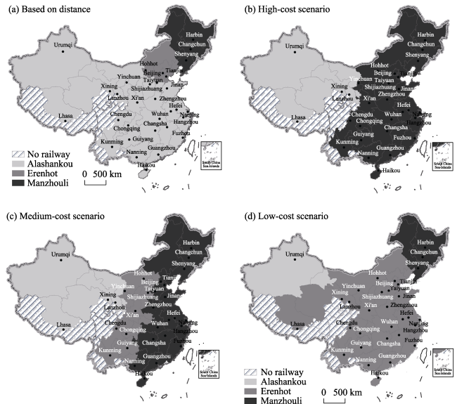
Facilities connectivity is a priority area for implementing the Belt and Road Initiative (BRI). The “China-Europe Railway Express” (CER Express) mode of transport organization links China with Europe by fast-track cargo rail. A major instance of facilities connectivity related to this project is an important practical and symbolic instance of BRI transport cooperation. The strategic significance of the CER Express and a number of operational issues are outlined, as are the implications of limited market potential for costs and competitiveness. A “hub-and- spoke” organizational model that can generate scale economies and reduce costs is proposed. To examine the establishment of an organizational model of this kind, the economic hinterlands of Alashankou, Erenhot, and Manzhouli are identified under high-, medium- and low-cost scenarios using an analytical methodology that determines distance and economic costs, and a number of transport hubs (that include Harbin, Zhengzhou, and Lanzhou) are identified. The results found that the cost of the routes from 314 Chinese cities to Moscow is the lowest via Manzhouli in the high- and medium-cost scenarios, but the routes change via Erenhot in the low-cost scenario. A number of policy recommendations should follow up.

Cite this article

WANG Jiaoe , JIAO Jingjuan , MA Li . An organizational model and border port hinterlands for the China-Europe Railway Express[J]. Journal of Geographical Sciences, 2018 , 28(9) : 1275 -1287 . DOI: 10.1007/s11442-018-1525-6

1 Introduction

The Belt and Road Initiative (BRI) proposed by China’s President Xi Jinping, including two main components of “Silk Road Economic Belt” and the “21st Century Maritime Silk Road”, is a new platform of economic and trade cooperation (Hu et al., 2014) that will contribute an orderly flow of goods and factors of production between BRI countries, an efficient allocation of resources, and deeper market integration (Liu, 2015). According to Vision and Actions on Jointly Building Silk Road Economic Belt and 21st-Century Maritime Silk Road, the BRI proposes five cooperation priorities: policy coordination, facilities connectivity, trade facilitation, financial cooperation and people-to-people bonds (Liu and Dunford, 2016). Of these priorities, facilities connectivity aims to connect China with Central Asia, West Asia, South Asia, Europe and Africa, and to manage maritime transport risks (Strait of Malacca, Suez Canal and South China Sea) by developing overland transport (Vinokurov and Tsukarev, 2017).
The development of land routes connecting China with Europe dates back at least to 202-208 BC. Called the Ancient Silk Roads, these routes played a role not just in trade but also in cultural and other exchanges (Rodrigue et al., 2013). The Morden Silk Roads date from the 1990s, when the Lanzhou-Xinjiang railway was connected with the Turkestan-Siberia railway, forming the entire New Eurasian Land Bridge along which the international transportation of passengers and goods started in 1992. In 2011 China opened the China-Europe rail cargo transportation service (hereinafter the “China-Europe Railway Express” (CER Express)) from Chongqing, China to Duisburg, Germany. By November 2017, 35 Chinese cities had opened CER Express services to 34 European cities in 12 European countries. The CER Express is now an important cooperative land transportation platform and a major driver of economic exchange and trade between China and BRI countries.
In the wake of the rapid development of the CER Express, its operations, problems, benefits, and related policy issues have been examined from managerial and economic perspectives (Li, 2016). A quantitative comparison of regional conditions, transportation costs, transportation time, and levels of service of all routes identified the Chongqing-Xinjiang-Europe route as the most economically viable (Fu, 2016). Abstracting from the value of the goods transported, Mo et al. (2015) argued that the CER Express has an adequate economic hinterland. To ensure that the CER Express operates normally and cost effectively, other authors have called for an increase in the area served and speed and the creation of a brand (Chen et al., 2015; Xie, 2016). Operational problems exist in relation to the interconnection between installations, operational organization, transportation costs, and the facilitation of customs clearance (Wang, 2015). Most of these problems continue to make profitability an issue. For these reasons and to identify the requirements for regular and profitable operations in a market system, this research seeks to clarify the organizational model of CER Express operation, the size of hinterlands and potential hubs. The current situation is outlined in the next section. Section 3 explores possible organizational models, while Sections 4 and 5 present a model used to identify the extent of CER Express transportation hinterlands and hubs. Section 6 draws some conclusions.

2 The current state of CER Express operations

CER Express scheduled high-speed freight train services between China and countries along the “Silk Road Economic Belt” (mostly in Europe) utilizes a “five fixed-point scheduling system” (fixed locations, fixed routes, fixed train numbers, fixed time, and fixed price) for shipping containers or fully-laden carriages along the whole route. By making the most of its advantages over ocean transport such as relatively shorter distances and shipping times, CER Express offers a scheduled service for the transportation of high value-added goods to Europe and other places from China (Mo et al., 2015). Due to its fast speed, high level of safety, and short transport time, CER Express provides a novel channel for transporting commodities on the Eurasian continent and plays a key role in driving cross-border organization and agreements in BRI countries.

2.1 Distinctive features of CER Express operations

The quantity of CER Express operations has steadily increased, gradually becoming a mainstay of back-and-forth land transport along the “Silk Road.” On March 19, 2011, the first CER Express service left Chongqing and travelled via the Alashankou border port crossing in Xinjiang through Central Asia to Europe. Called the“Chongqing-Alashankou-Europe Railway”, it opened a new era for rail freight, providing an alternative to shipping by sea or air. Subsequently, many other cities opened routes to Central Asia and Europe via Alashankou, Manzhouli, Erenhot and Horgos. Included were the “Wuhan-Alashankou-Europe Railway” (2012), the “Chengdu-Alashankou-Europe Railway” (2013), the “Chengdu- Erenhot-Europe Railway” (2013), the “Zhengzhou-Alashankou-Europe Railway” (2013), the “Zhengzhou-Erenhot-Europe Railway” (2013), and the “Suzhou-Manzhouli-Europe Railway” (2013). The “Chongqing-Europe Railway,” the “Chengdu-Europe Express Rail,” the “Chang’an Line” (Xi’an to Europe), the “Wuhan-Europe Railway,” and the “Zhengzhou-Europe Route” gradually established regular scheduled services. In the past six years, the total number of CER Express services has increased rapidly from 17 trains in 2011 to 3217 in the eleven months from January to November 2017. Inbound services started in 2014, increasing to 1105 trains in 2017, with 51.02% of the capacity of trains returning to China used in 2017. The sustained growth of outbound service trains will continue and will help the normal operation of the CER Express in future (Figure 1).
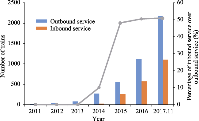
Figure 1 The growth of China-Europe Railway Express, 2011-2017
Nationwide, a system of regular scheduled CER Express operations is emerging along three (western, central, and eastern) operational corridors. An analysis of CER Express domestic routes reveals that there are 18 passing through the western border ports at Korgas and Alashankou, 17 passing through the eastern ports at Manzhouli and Suifenhe, and 4 passing through the central port at Erenhot. An analysis of the distribution of CER Express operations reveals that in 2015, around 57% of scheduled trains passed through Alashankou, 35% passed through Manzhouli, and 8% passed through Erenhot on their way to Central Asia and Europe. Of these, the key routes passing through Alashankou were the Wuhan-Europe, Chengdu-Europe, Chongqing-Europe, Zhengzhou-Europe, and Hunan- Europe lines. The key routes passing through Erenhot were the Chengdu-Europe, and the Zhengzhou-Europe lines. The key routes passing through Manzhouli were the Hubei- Europe, Jiangsu-Europe, Hunan-Europe, Chongqing-Europe, Guangdong-Russia, and Guangdong-Europe lines. An analysis of the international routes reveals that the currently operational CER Express routes to Europe all utilize the northern and central routes, and the southern routes are yet to be utilized. Of the routes in use, the northern routes leave China at either Manzhouli or Erenhot, and cross the Siberian Continental Bridge in Russia to reach Europe via Moscow. The central routes exit China at either Alashankou or Korgas, and go through Kazakhstan to Moscow and then on to Europe. Both routes utilize Moscow as the key hub for entry into Europe.
Chinese cities with CER Express services are gradually extending from the western region towards the southeastern seaboard, while cities outside of China are gradually extending from western and central Europe towards eastern Europe, and even towards western and central Asia. In 2011, just one city (Chongqing) had CER Express services. In 2012, Wuhan opened a CER Express service to Czemelnik/Pardubice. In 2013, 4 additional cities opened CER Express services. Two of these (Guangzhou and Suzhou) are located in the eastern region of China and the other two (Zhengzhou and Xi'an) are in the central and western regions. In 2014, six cities added new services: Tianjin, Yiwu and Yingkou, located in the eastern coastal region, and Wuwei, Changsha and Hefei in the central and western regions. In 2015, 12 cities were added. In 2016, five of nine newly-added cities were in the eastern region, with the exceptions of Dongguan, Xiamen and Lianyungang these newly added cities were in the central and western regions. In 2017, four cities were added.
Till the end of November 2017, there were 57 CER Express routes linking 35 Chinese cities, including Xi’an, Chongqing, Wuhan, Beijing and Yiwu with 34 European cities in 12 countries. Amongst, 16 of 35 Chinese cities with CER Express services (a group that excluded Shanghai) were located in the eastern region, 9 in the central region and 10 cities (excluding cities in Tibet, Guizhou and Guangxi provinces which did not have services) were in the western region. Meanwhile, at national level, CER Express services to France and Holland in western Europe, Germany, Poland, the Czech Republic, and Slovakia in central Europe, Russia and Belarus in eastern Europe, Spain in southern Europe, and Kazakhstan, Turkey, Afghanistan, Iran, Uzbekistan, and Mongolia in Asia had opened. At city level, 34 European cities had successively opened up CER Express services, starting with Duisburg (2011) and Melnik and Pardubice in the Czech Republic (2012), and extending to Warsaw and Lodz in Poland (2013), Hamburg (2013), Moscow (2013), and Zhem in Kazakhstan (2013).

2.2 CER Express operational issues

A number of operational technological and economic issues affect CER Express operations (Wang et al., 2017):
(1) A lack of systematic top-level design gives rise to competition between each CER Express line. Up to 2017, 35 Chinese cities had opened up westbound CER Express routes to Europe or Central Asia. All of these routes were operated and organized by local government. Operational effectiveness was adversely affected by a lack of central government coordination, of systematic design and of an overall plan and operational arrangements. Most of the CER Express routes had similar and coincident long-haul routes, leading potentially to a waste of capital and resources and inefficient capacity utilization.
(2) The sources of freight in China are dispersed and there is too little freight for the eastbound CER Express routes, rendering it uneconomic for transportation. Under the impact of the China-Europe trade structure, the industrial structure of the cities of departure, and the low costs of ocean shipping, the supply of freight for CER Express services is small and dispersed. Most CER Express services remain undersupplied with freight even when there is only one scheduled train per week, making it difficult to support regular operations. Meanwhile, the goods exported from Europe via rail to China comprise a small quantity of precision instruments, machinery, and high-quality apparel. Most of the scheduled trains are unable to reach capacity on the return journey, increasing unit transportation cost.
(3) Restrictions on the connectivity of logistics corridors increase operational costs. China and western Europe use standard gauge rail (1435 mm), whereas Russia, Mongolia, countries in Central Asia and other former Soviet countries use broad gauge (1520 mm). As rail gauges differ (Figure 2), most international China-Europe scheduled trains must undergo at least two transshipments. In addition shipments are often stopped at ports of entry due to loading restrictions or overloading using up a lot of time. Alongside the costs of border stops and transshipment, CER Express services add 50% to the costs of slow trains, making operational costs much higher than for intermodal rail-ocean or river-ocean shipment.
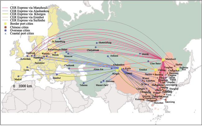
Figure 2 The departure and destination cities of China-Europe Express trains
(4) CER Express services rely on subsidies from local governments to cover losses. At present, the vast majority of CER Express’ operations require government subsidies. To guarantee operations and attract freight, all local governments have established subsidy schemes, stipulating that they will cover costs in excess of those of ocean shipping; these subsidies are around 2000-3000 US dollars per container at the minimum in 2014. Under these conditions, the costs of most scheduled transportation services are roughly equivalent to or slightly higher than those of ocean shipping, although CER Express services takes less time. If local government did not provide subsidies, all CER Express routes would find it difficult to remain operational. In addition, CER Express services now face competition from Russia’s “Iron Silk Road” which utilizes the Trans-Siberian Express (Lee, 2004).
Consequently, to establish regular and cost effective services the CER Express must reduce costs, increase market competitiveness and increase demand, making it essential to identify a rational and effective organizational model and identify the economic hinterlands of border ports and network hubs and nodes.
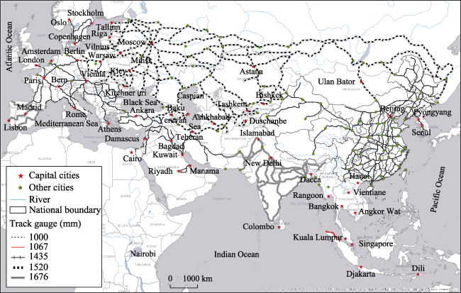
Figure 3 Distribution of rail track gauges by size in BRI countries

3 An organizational model for CER Express services

CER Express services are affected by the standards and technological level of rail infrastructure and equipment, by operational organization and policies in each of the countries involved, and by the complicated structure of regional geopolitics (Xu, 1997; Otsuka, 2001) as well as by high transportation costs that severely limit the international transportation of freight via rail between China and Europe, Central Asia, and Russia (Xu, 1997). Even though CER Express transportation costs have now dropped from US $9000 per standard container to US $6000, costs are still high when compared to ocean shipping. Thus, rational organization and regular high frequency scheduling of freight are keys to long-term and stable operations. At present, an irregular supply of freight, uncertainties for freight forwarders, and companies reneging on their contracts to carry freight are major issues impeding smooth full capacity operations.
There are three models of the spatial organization models of rail and air transportation networks (Jin et al., 2005; Wang, 2008): point-to-point, multi-station, and hub-and-spoke systems (Figure 4):
(1) The point-to-point organizational model involves direct high-speed connections between the source of freight and the market for it. This model is suited to cities with an adequate supply of freight, and generates sufficient returns from supply and market areas that are the smallest in scope.
(2) The multi-station dependency model involves stopping one or many times between the point of departure and destination, picking up goods along the way. Stopping compensates for a lack of freight at the point of departure, and results in a beads-on-a-string spatial organization model. This model can meet the transportation needs of cities along the railway route, but is slower due to stopping, loading, and unloading with adverse effect on the efficiency of freight transport.
(3) The hub-and-spoke system combines a “central hub” and a “network of spokes” with a variety of modes of communication to ensure that “flow” costs are minimized. This spatial networking model is economical and convenient (Jin et al., 2005), and is suited to regions where the source of freight is relatively dispersed, with hubs and nodes used to reduce the costs and increase the scale economies associated with the collection and distribution of goods.
As the supply of freight for CER Express routes is relatively dispersed, a hub and spoke model can raise operational efficiency. In particular, by fixing scheduled times and core destinations, localities share routes and combine transport operations. For each point of departure collection and distribution hubs and nodes are identified according to how economical they are in terms of both time and money. Once this new organization model is established, goods are transported to a border port. After clearing customs these goods are sent to a hub city abroad, and from there they are transported onwards to their destinations. In this arrangement, hubs perform the function of organizing, collecting, and distributing goods. As the CER Express involves cross-border transportation, the choice of border ports has a direct bearing on transport efficiency of transportation and also plays a key role in the selection of hubs. The rest of this article will therefore dwell on these issues.
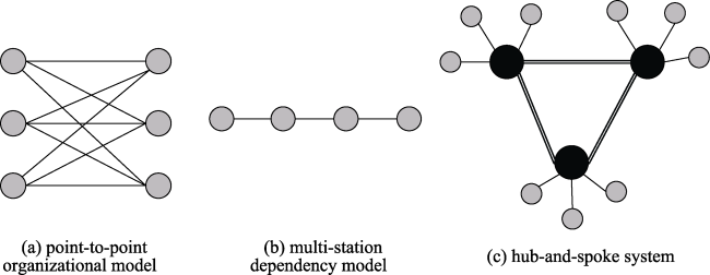
Figure 4 The organizational models of railway freight network

4 Computing the hinterlands of CER Express routes

The CER Express has three transportation channels. The corresponding ports are Alashankou and Korgas in the west, Erenhot in the center, and Manzhouli and Suifenhe in the east. Due to the close proximity of Alashankou to Korgas, and of Manzhouli to Suifenhe, and the existence of relatively fewer routes through Korgas and Suifenhe compared with the others, Manzhouli, Erenhot, and Alashankouas were chosen and their economic hinterlands were identified.

4.1 Research methodology

A model of competition in multi-modal transportation networks (Mo et al. 2015) was used to identify port hinterlands. As there are differences in rail freight costs in different countries, transport costs were computed for routes from Chinese cities via the three border ports to Moscow, as lies at the intersection of all three CER Express channels. Transport costs include those of time and money. Time cost was calculated from data on and average speed of travel by the CER Express. Money costs include the fixed costs and the variable costs related to freight volume. Variable costs were determined by the volume of freight and distance of transport. The model itself was given by:
Ti = Di / S; Ci = F + Di / P (1)
where Ti represents the shortest travel time by rail from a certain Chinese city (i) to Moscow; Ci indicates the lowest transportation costs for that route; Di is the shortest distance by rail transportation, calculated using the Network Analysis Tools in ArcGIS; S indicates the average speed of the railway; P represents the operational costs (traffic price) per unit of distance; F indicates fixed expenses (including costs of loading and unloading, costs of technical tasks, and costs of processing documents and information). As there is little difference in these fixed expenses between the 57 routes through the three border ports, they were not taken into consideration in this study.
The transport costs via Alashankou and Manzhouli are relatively stable, standing at $0.7/FEU.km and $0.4/FEU.km, respectively, but the transport costs via Erenhot are yet to be settled. In this study three scenarios were considered: high, medium and low transport costs (Table 1). As the Mongolian railways are partially controlled by Russia companies, transport costs for the route from Erenhot via Mongolia and Russia were determined using rates used for routes via the Manzhouli and Alashankou ports, which are given different cost rates when passing through Russia. A high rate was set at $0.6/FEU.km. As this rate is lower than that in Kazakhstan, this route has a cost advantage. A low rate from Erenhot via Russia and Mongolia was set at $0.4/FEU.km. This rate is the same as the rate for goods leaving China via Manzhouli and travelling on the railway in Russia. This route potentially competes with the Trans-Siberian Express. A medium rate was set at $0.5/FEU.km, since the distance from Erenhot traveling through Russia by the CER express was between the distance from Manzhouli and from Alashankou. We assume Russia will prefer to setting this cost rate for the CER from Erenhot according to the distance passing through Russia.
Table 1 Railway freight traffic charges through three border ports ($/FEU.km)
Border port Cost rate Border port Cost rate
High Medium Low
Alashankou China: 0.6
Russia: 0.7
Kazakhstan: 0.94
Erenhot China: 0.6
Russia: 0.6
Mongolia: 0.6
China: 0.6
Russia: 0.5
Mongolia: 0.5
China: 0.6
Russia: 0.4
Mongolia: 0.4
Manzhouli China: 0.6
Russia: 0.4

4.2 Results

The study area comprises 310 prefecture-level administrative units and 4 municipalities connected to the Chinese railway system (Figure 5). The results based on travel distance indicated that the average shortest travel distance between the 314 cities and Moscow was via Alashankou followed by those via Erenhot and Manzhouli. The average travel distance from 314 cities to Moscow via Alashankou was 7990 km, which was equal to 88% and 82% of the average distances via Erenhot and Manzhouli, respectively. Geographically, the shortest travel distance to Moscow for 82% of cities (259) was via Alashankou. These cities included all the cities in the central and western regions and most of the cities in the eastern region. For 18 cities mainly in northern Hebei Province, central Inner Mongolia Autonomous Region, and south western Liaoning province the shortest distance was via Erenhot. For 37 cities located mainly in the northeastern region the shortest route was via Manzhouli.
Figure 5 Economic hinterlands of the three border ports, as determined by distance and travel cost considerations
In the high- and medium-cost scenarios, average travel cost from Chinese cities to Moscow was the lowest via Manzhouli. In the low-cost scenario it was the lowest via Erenhot. More specifically, in the high-cost scenario, the average travel cost from 314 cities to Moscow via Manzhouli was 87% and 84%, respectively, of that via Alashankou and Erenhot. In the medium-cost scenario the corresponding values were 87% and 95%, respectively. In the low-cost scenario, the average travel cost for all cities via Erenhot to Moscow was just 78% and 90%, respectively, of those via Alashankou and Manzhouli. The economic hinterland of three border ports changed along with the transport cost rate. In the high-cost scenario, costs were minimized for the vast majority of cities on the route via Manzhouli. For only 29 north western cities transport via Alashankou was cheaper. In the medium-cost scenario, the economic hinterland of Alashankou was the same as in the high-cost scenario. However the economic hinterlands of Erenhot included an additional 74 cities, mainly located in provinces of Yunnan, Sichuan, Shaanxi and Shanxi, as well as Chongqing Municipality and autonomous regions of Inner Mongolia and Ningxia, with the rest remaining in Manzhouli's economic hinterland. In the low-cost scenario, the economic hinterland Erenhot extended further east and west to include 84% of cities, while the economic hinterlands of Alashankou and Manzhouli were reduced to 14 and 36 cities, respectively. Overall, the spatial distribution of the economic hinterlands of different ports was heavily influenced by the travel cost rate. In all the three scenarios, the cities in Xinjiang lay in the economic hinterland of Alashankou, while most cities in Northeast China lay within Manzhouli’s economic hinterland; the cost minimizing border ports for the remaining cities changed with changes in the transport cost rate. A unified pricing system and government priorities would help to form a rational organization of CER Express.

5 Identifying hubs of CER Express

5.1 Hub candidates

Railway ports and marshalling stations are technical determinants of railway hub allocation, directly affect CER Express traffic distribution, the duration of clearance procedures and the efficiency of train make-up and constrain railway hub construction. By the end of 2016, there were twenty formal railway ports and eight temporary railway ports in China, located in 27 cities. Meanwhile, there were 15 networking marshalling stations, 17 regional marshalling stations and 17 local marshalling stations in 44 cities (Table 2).
Table 2 Railway ports and marshalling yards in China
Railway port City Marshalling station Station
Formal Dongguan, Guangzhou, Shenzhen, Foshan, Zhaoqing, Pingxiang, Zhengzhou, Suifenhe, Harbin, Tumen, Hunchun, Ji’an, Dandong, Manchuria, Erenhot, Alashankou, Hekou, Beijing, Shanghai, Horgos Networking South Harbin, West Shenyang, South Shenyang, Shanhaiguan, Changchun, Shijiazhuang, West Jinan, North Xuzhou, North Fuyang, East Nanjing, Nanxiangm, Yingtan, North Zhangzhou, North Zhuzhou, North Xiangfan etc.
Temporary Chongqing, Chengdu, Xi’an, Urumqi, Wuhan, Donggaun, Yiwu, Ganzhou Regional Sanjianfang, Siping, Harbin, Nancang,West Datong, West Xiangtang, West Jiang’an, South Wuchang, North Hengyang, North Guangzhou, South Liuzhou, East Xi’an, East Baoji, West Lanzhou, East Chengdu, West Chongqing, South Guiyang etc.
Local Mudanjiang, South Tongliao, Meihekou, North Taiyuan, Qiaosi, Genshanmen, West Huainan, West Qingdao, Laizhou, South Huaihua, West Baotou, Yingshuiqiao, South Wuwei, West Urumqi, East Kunming, East Andong

Source: The table was compiled with data from http://www.chnrailway.com.

In the light of the technical determinants of CER hub allocation, possible hubs are Beijing, Chengdu, Guangzhou, Harbin, Shanghai, Wuhan, Xi’an, Zhengzhou, Chongqing and Urumqi. As the 13th Five-year Plan for the development of national ports identified Lanzhou as a railway port, emphasizing its significance for CER Express western line, Lanzhou was added. Since Beijing, Shanghai and Guangzhou are already major transportation hubs, with developed transport systems, and are in particular coastal cities with advantages in maritime transportation, they were considered unsuitable for CER Express hubs (Wang et al., 2017), leaving eight candidate cities.

5.2 Hub recommendation

The collection-distribution ability of railway container centers, transportation hubs, highway hubs and logistics zones is crucial for the costs and benefits of CER Express services, and plays an important role in identifying and evaluating hubs. Factors affecting collection-distribution ability are intrinsic and exogenous. For example, an intrinsic factor is a distance between a local source of freight and ports. Exogenous factors are the hinterland geographies, the costs of distributing goods etc. As all of the eight candidate cities were railway container centers, national transportation hubs, first level national logistics zones and national highway hubs located along the trunk railway network, their collection-distribution abilities differed little, making the distance between ports and their hinterlands more important. In the case of the western corridor, Chongqing and Chengdu are adjacent. Also, goods to West need to be delivered via Lanzhou. Compared to Urumqi, Lanzhou is closer to the hinterland. Though both Lanzhou and Xi’an are located along the Longhai (Lianyungang-Lanzhou) line, only Lanzhou can collect and distribute goods in Southwest China giving it a larger hinterland. In the case of the Central corridor, CER Express operations via Zhengzhou were better than via Wuhan and its hinterland was wider. In the case of the East corridor, only Harbin had a railway hub, and had CER Express services operated. Lanzhou, Zhengzhou, and Harbin were therefore identified as initial West, Central and East corridor hubs. Other cities can subsequently function as hubs. At the same time, Lanzhou should focus on collecting and distributing goods from/to Northwest and Northeast China, Zhengzhou should be responsible for goods north of the Yangtze River, and Harbin should mainly collect and distribute goods in Northeast China.

6 Conclusions and discussion

With the development of the BRI, local governments are promoting the development of CER Express services, with a view to change China’s traditional foreign trade transportation system. There is no doubt that the CER Express has provided a new platform for transporting goods between Asia and Europe, and has become an exemplar of transport cooperation between BRI countries. CER Express services have significantly improved the convenience and accessibility of cross-border rail freight transportation, and the border ports of Alashankou, Erenhot, and Manzhouli have their own varied hinterlands according to different transport cost rate. All CER Express via Alashakou to Moscow or other major cities in West Europe have the shortest travel distance. However, the results will vary if we discuss the travel cost which is more concerned by all enterprises along the BRI. According to calculated hinterlands of CER Express services from the three border ports, the average travel cost from the 314 Chinese cities to Moscow are the lowest via Manzhouli in the high- and medium-cost scenarios, which is only 87% and 84% of the cost compared to the CER routes respectively through Alashankou and Erenhot in the high-cost scenario, and only 87% and 95% of the cost compared to through Alashankou and Erenhot in the medium-cost scenario. In the low-cost scenario, the CER routes through Erenhot have the lowest travel cost. Besides, the 314 cities also have different priority routes via the three border ports for paying the lowest travel cost.
The reduced cost and improved accessibility by CER Express service easily leads people and the Chinese local governments to mistakenly think that trade between countries on the Eurasian continent will largely shift from ocean shipping to rail transportation. However, the future role of CER Express services in China’s international trade transportation is limited, as it is constrained by the railway standards, the technological level of railway installations, operational organization and policy in every country involved, the complicated structure of regional geopolitics, and relatively high costs compared with ocean shipping. CER Express services are only profitable if used to transport suitable goods (such as high value-added products) or within a suitable regional contexts (such as interior regions far away from seaports). Adopting an effective organizational model for transportation (such as a hub-and-spoke network), setting up collection and distribution hubs, creating a unified brand, and bringing about an organized system for supplying freight for return journeys to China will help create economies of scale and expand the scope and viability of CER Express services. Meanwhile, along with the development of west China and the movement of some enterprises from the coastal to the inland areas of China, the demand of CER Express services will surely have a large increase in the near future. Nevertheless it is imperative the local governments clearly realize the objective fact that CER Express services will only ever serve to supplement ocean shipping and can never replace it.

The authors have declared that no competing interests exist.

[1]
Chen Rong, Shi Guojin, 2015. Thoughts on creating China-Europe block train with concept of “One Economic Belt, One Silk Road”.Railway Transport and Economy, 37(11): 71-74. (in Chinese)

[2]
Fu Xinping, Zhang Xue, Zou Min et al., 2016. Analysis on economics of China-Europe block trains based on the value model.Railway Transport and Economy, 38(11): 1-5, 11. (in Chinese)In order to compare economics of China-Europe block trains, this paper focuses on the general situation of seven train paths and establishes the value model with four appraisal indexes, including regional condition, freightage, transit time and service standard. Based on the model, the optimal train path is selected through value comparison. Taking the result into account, this paper puts forward some suggestions to improve the economic efficiency of China-Europe block trains, including introducing relevant policies to solve the problem of supply, unifying foreign freight, improving the logistics services system, and strengthening the information system construction.

[3]
Gong Peiping, Song Zhouying, Liu Weidong, 2015. Commodity structure of trade between China and countries in the Belt and Road Initiative area.Progress in Geography, 34(5): 571-580. (in Chinese)Economic cooperation is one of the priority areas in the "Belt and Road Initiative" proposed by China.It is important to examine the characteristics and patterns of development of trade between China and countries in the "Belt and Road Initiative" area, for achieving "unimpeded trade" and promoting economic prosperity and regional cooperation. Under this background, this article reviews the changing trend of commodity structure of trade between China and countries in the "Belt and Road Initiative" area, and analyzes the commodity structure and pattern, based on the revealed comparative advantage index(RCA), sensitive industry identification method,and k-medium value clustering. The results show that the commodity structure of China's export to these countries has improved, while import has been more centralized with increasing share of energy. Second, the main products that China exports to these countries are mechanical equipment and textiles and garments, while the main products that China imports are mostly energy, textiles and garments, and mechanical equipment. Third,sensitive industries involved in China's exports include clothing and shoes, nonmetallic minerals, transportation equipment and so on, and those involved in China's imports are mainly ores, energy, and some primary processed products. Fourth, at the provincial level, eastern, central, and some western provinces that do not share border with other countries, are mainly connected to Southeast Asia, West Asia, and Middle East, while western and northern border provinces are mainly dependent on trade with neighboring countries in the area, and have more ties with Central Asia, South Asia, and Mongolia-Russia. Most eastern provinces, central provinces, and several fast-growing western provinces are mainly exporting mechanical equipment, while most northwestern provinces are mainly exporting clothing. On the other hand, energy is the main product imported to Qinghai, Xinjiang, Liaoning, Heilongjiang, and other eastern provinces, while ores and metal products are main imported to most western provinces.

[4]
Hu Angang, Ma Wei, Yan Yilong, 2014. Connotation, definition and passage of “Silk-road Economic Belt” strategy. Journal of Xinjiang Normal University (Edition of Philosophy and Social Sciences), 35(2): 1-11. (in Chinese)Central-Asia economic belt is the core area of Silk-road economic belt.The economic belt on the rim of central Asia is a pivotal area of Silk-road economic belt. Euro-Asian economic belt is the extended area of Silk-road economic belt, which is featured by a set of transformation in national security strategy: from passive strategic defence to active strategical aggression; from unitary borderland security to multiple-dimension cooperation; separation of internal affair from diplomacy to integration of both internal and external affairs. The Silk-road economic belt is contemporary trade and economic cooperation in advanced edition on the basis of ancient Silk-road concept with strategic significance: by nature, it is a history-beyond edition integrating political, economic, internal and external affairs together with transcending time and space; by content,it is a comprehensive policy edition combining both westward opening up and western development; by form, it has undergone several generations of leading body to project national security and economic strategies in advanced edition.The Silk-road economic belt to be constructed in joint effort to open up a continental strategic passage in order to promote westward opening strategy, which involves all-round strategic project; in strategic framework, based on Shanghai Cooperation Organization, multiple mechanism needs to advance simultaneously; in tactics, easier thing is to be done before difficult thing in steady manner;in strategy, dominated by trade and economy,multiple dimensions need to move ahead. Through security and stability, trade and economic development and cooperation in public and diplomatic affairs, we constantly push ahead communication in policy between China and central-Asian countries, highway connection, trade free flow and monetary circulation as well as friendly regional cooperation.

[5]
Jin Fengjun, Wang Chengjin, 2005. Hub-and-spoke system and China aviation network organization.Geographical Research, 24(5): 774-784. (in Chinese)

[6]
Lee J Y, 2004. Iron Silk Road: Prospects for a land bridge through Russia from Korea to Europe.Post-Soviet Affairs, 20(1): 83-105.

[7]
Li Jiafeng, 2016. Study on countermeasures of optimizing China-Europe block trains under “the Belt and Road” strategy.Railway Transport and Economy, 38(5): 41-45. (in Chinese)The silk road economic belt and the 21st-century maritime silk road"("the Belt and Road") strategy provides opportunities and challenges for railway development in China, and also provides important support for China-Europe block train operation from the aspects such as establishing import-export logistic corridor and promoting rapid development of cross-border electronic commerce. Through analyzing the operation status and problems of China-Europe block trains, this paper puts forward countermeasures of optimizing the trains under "the Belt and Road" strategy, which are optimizing layout of railway logistic center, strengthening construction of international transfer logistic node, reinforcing equipments and facilities of railway yard, increasing service quality of China-Europe block trains and enriching transport product categories of the trains, so as to make the trains becoming the new power of driving economic and trade development of the countries along the line.

[8]
Liu Weidong, 2015. Scientific understanding of the Belt and Road Initiative of China and related research themes. Progress in Geography, 34(5): 538-544. (in Chinese)The Belt and Road Initiative here the "Belt" stands for the Silk Road Economic Belt and the "Road" stands for the 21 st Century Maritime Silk Road s a call of China for new modes of regional economic cooperation under the trend of development of economic globalization. It targets at promoting orderly and free flow of economic factors, efficient allocation of resources, and deep integration of markets; enabling the countries along the Belt and Road to achieve economic policy coordination and carry out broader, deeper, and more efficient economic cooperation; and jointly building an open, inclusive, and balanced regional economic cooperation architecture. Thus the Belt and Road Initiative is an alternative road to further economic globalization, but contains ideas that are different from the past, that is, the spirit of the Silk Road鈥 "peace and cooperation, openness and inclusiveness, mutual learning and win-win." Based on such an understanding, this article first analyzes the general background of the Belt and Road Initiative against economic globalization and the changing configurations of the world, and then discusses the Initiative's spatial connotation by revealing its multi-scalar and transscalar characteristics. The article points out that the Belt and Road Initiative is a national strategy, rather than a regional strategy, to coordinate all-around opening of China to the world and promote further integration of the country into the global economy. Last, the article suggests several research themes in geography that are brought about by the Belt and Road Initiative, including geopolitical studies, geography of countries of the region to explore cooperation opportunities, foreign direct investment theories advanced by the Belt and Road Initiative, and optimization of transcontinental transportation.

[9]
Liu W D, Dunford M, 2016. Inclusive globalization: Unpacking China’s Belt and Road Initiative.Area Development and Policy, 1(3): 323-340.Abstract China’s Belt and Road Initiative (BRI) is a call for an open and inclusive (mutually beneficial) model of cooperative economic, political and cultural exchange (globalization) that draws on the deep-seated meanings of the ancient Silk Roads. While it reflects China’s rise as a global power, and its industrial redeployment, increased outward investment and need to diversify energy sources and routes, the BRI involves the establishment of a framework for open cooperation and new multilateral financial instruments designed to lay the infrastructural and industrial foundations to secure and solidify China’s relations with countries along the Silk Roads and to extend the march of modernization and poverty reduction to emerging countries.

DOI

[10]
Chengchao, Xu Qian, 2015. Space disequilibrium and interconnection policy for transportation infrastructure in new Silk Road Economic Belt.Journal of Shanghai University of Finance and Economics, 17(2): 44-53, 85. (in Chinese)This paper studies space disequilibrium of transportation infrastructure and its influencing factors under the background of the New Silk Road Economic Belt.Based on the panel data of transportation infrastructure in the New Silk Road Economic Belt from 1997 to 2012,it arrives at the empirical results as follows:firstly,the transportation infrastructure in the New Silk Road Economic Belt develops rapidly,but is featured by space disequilibrium;secondly,the space gap in northwest regions is greater than the one in southwest regions;thirdly,the space polarization of roads has a trend from high to low,while the space polarization of rail and capital are showing an M-shape trend;fourthly,the transportation infrastructure is affected by basic economic factors,human resources factors,foreign trade factors and new economic geography factors,but the effects of factors are different.The research expands the study about space disequilibrium of transportation infrastructure,and provides the policy basis for the New Silk Road Economic Belt to coordinate the development of transportation infrastructure and implement effectively interconnection strategy.

[11]
Mo Huihui, Wang Jiaoe, Song Zhouying, 2015. Economically suitable areas of China’s transnational container transport by land in the Silk Road Economic Belt.Progress in Geography, 34(5): 581-588. (in Chinese)China's transnational container transport by land in the Silk Road Economic Belt(SREB) has increased quickly, and rail is the most important method for land transport. By analyzing the current transnational container transport between China and other countries in the SREB, we first build a simulation model for multimodal transport competition, and then examine the economically suitable areas for China's transnational container transport by rail and maritime transport based on travel distance, travel time, and transport cost. The results show that Central Asia, Mongolia, and the central and eastern areas of Russia have comparative advantages for transnational container transport by rail as compared to maritime transport. To Ukraine, Belarus, Poland, and the western areas of Russia, transnational container transport by rail has relative comparative advantages. Meanwhile, maritime transport(or sea-land intermodal transport) costs less than rail transport from China to most of the remaining areas of Europe and Asia.

[12]
Otsuka S, 2001. Central Asia’s rail network and the Eurasian Land Bridge.Japan Railway & Transport Review, 28: 42-49.

[13]
Rodrigue J P, Comtois C, Slack B, 2013. The Geography of Transport Systems. 3rd ed. London, UK & New York, NY: Routledge.

[14]
Song Zhouying, Che Shuyun, Wang Jiaoeet al., 2015. Spatiotemporal distribution and functions of border ports in China.Progress in Geography, 34(5): 589-597. (in Chinese)

DOI

[15]
Vinokurov E, Tsukarev T, 2017. The Belt and Road Initiative and the transit countries: An economic assessment of land transport corridors.Area Development and Policy, doi: 10.1080/23792949.2017.1385406.react-text: 295 A system of econometric models designed for forecasting target monetary indicators as well as conducting monetary policy scenarios analysis is presented. The econometric models integrated in the system are represented in the error correction form and are interlinked by means of monetary policy instruments variables, common exogenous variables characterizing external shocks, and monetary policy... /react-text react-text: 296 /react-text [Show full abstract]

DOI

[16]
Wang Chengjin, 2008. Spatial organizational network of Logistics Company in China.Acta Geographica Sinica, 63(2): 135-146. (in Chinese)<p>With the development of the third party logistics, logsitcs company as a professional economic form to organize logistics activities with the spatial network is well aware of the growing importance. Much attention is paid to the spatial network of logistics company. Based on discussion about research process of logistics company, this paper analyzes the theory about spatial network of logistics company and discusses its spatial system, function ties and operation mechanism. Logistics company is composed of corporation factors and logistics factors with different spatial attributions, moving regularity and organization characteristics whose united operation generates function differentiation and location separation among different members of logistics company, which develops into the spatial network including organizing network of corporation factor and operating network of logistics activities, namely the static phase and dynamic phase. Logistics company constructs its corporation factor network at urban and regional scales. Urban network includes the headoffice, operating department and distribution center with different corporation functions or logistics functions. The headoffice is located at urban centre, the distribution centre tends to be in the suburbs of a city, and the operating department is situated in the regions with many logistics activities. Regional network includes headquarter, regional headoffice, local branch, local office and operating department with different corporation functions or logistics functions. Corporation headquarter tends to be located in large cities, regional headoffice is generally at a political-economic centre in each logistics operating region, local branches are concentrated in capital city, economic centre and transport hub. Operating network of logistics activities comprises scheduled transport line, distribution system and logistics network. Transport line is the primary operating way of logistics activities which includes trunk and branch transport lines. Distribution system helps logistics company to transfer the cargoes throughout the country and improve its market competition with the development of regional distribution centre, urban regional distribution centre and urban distribution centre. The optimization, amalgamation and intertexture of scheduled transport line and logistics distribution system can develop into the primary operating mode of logistics network, namely hub-and-spoke system.</p>

[17]
Wang J E, Cheng Y, Mo H H, 2014. The spatio-temporal distribution and development modes of border ports in China.Sustainability, 6(10): 7089-7106.Border ports play a substantial role in socio-economic exchanges, which reflect the diplomatic relations between neighboring countries. This paper maps and analyzes the evolution process of border ports in China since the 1930s, in terms of the spatial distribution, transport modes, cargo and flows of people. Four development modes of border ports and cities are summarized based on the functions and development level of border ports and their proximity to urban core areas. The four modes include: (1) Port-Port mode; (2) City-Port-Port-City mode; (3) City (Port)-Port-City mode; (4) City (Port)-City (Port) mode, which also reflect the spatio-temporal evolution process of certain border ports and cities. The results show that the development of border ports is closely related to the bilateral relations with neighboring countries and their complementarities of natural resources and economic development, national foreign policies, as well as the physical, historical and cultural context. The findings of this study are helpful to promote the sustainable development of the border port system which is crucial for win-win reciprocity between China and its neighboring countries.

DOI

[18]
Wang Jiaoe, Jing Yue, Wang Chengjin, 2017. Study on better organization of China-Europe express train.Bulletin of Chinese Academy of Sciences, 32(4): 370-376. (in Chinese)Connectivity of infrastructure is a priority component of China's Belt and Road Initiative. As an important achievement of such connectivity and a symbolic co-transport platform, China-Europe Express Train(CEET), organized and operated by Chinese local government, has become a new way for cargo transportation among China, Central Asia, and Europe. This paper first analyzes the significance of CEET as well as its problems, and then raises two view points to correctly understand CEET, that is, CEET plays a limited role in the shipment of China's imported and exported commodities, and this transport model can achieve profit only if selective goods(e.g., high-value and low-weight goods) are shipped to appropriate locations(e.g. the hinterland of the Eurasian Continent). In fact, the CEET accounts for only a tiny share of China's international trade cargo. In the end, the paper suggests to adopt a hub-and-spoke mode and set up a few transport hubs as well as foster the brand of "China Railway Express" to cut costs and improve efficiency.

[19]
Wang Jiaoe, Wang Han, Jiao Jingjuan, 2015. China’s international aviation transport to the Belt and Road Initiative area.Progress in Geography, 34(5): 554-562. (in Chinese)The Belt and Road Initiative aims to promote the connectivity of Asian, European, and African continents and adjacent seas and establish and strengthen partnerships among the countries along the Belt and Road Initiative area. The construction of international air transport network and land transport and maritime shipping corridors constitutes the three basic parts of transportation infrastructure and connectivity. This article employs the OAG(formerly Official Airline Guide) flight schedule data of 2014 to first analyze the spatial pattern of international air linkages between China and the other 64 countries in the Belt and Road Initiative area, and then identify China's international hub airports and sub-regional hubs based on the graph theory model. The results indicate that:(1) the coverage and intensity of international air passenger linkages is broader and higher than that of air cargo linkages. China's international air passenger linkages mainly focus on Thailand, Russia, and Singapore;while cargo linkages are primarily with Russia;(2) both the international air and cargo linkages show the "hubspoke" and "point to point" patterns;(3) among the domestic airports, international air linkages are concentrated in only a few. Shanghai, Beijing, and Guangzhou are identified as the international air passenger hubs and Shanghai as the international cargo hub to the Belt and Road Initiative area.

[20]
Wang Yangkun, 2015. Status, problems and suggestions on development of Sino-Europe block trains.China Transportation Review, 37(Suppl.1): 70-75, 89. (in Chinese)This essay analyses the status on the development of Sino-Europe block trains and points out the existing problems from the perspectives of market demand,transport organization and operation mechanism,then puts forward the suggestions on the aspects of market position,structural reform,subsidy policy and integration.

[21]
Xie Ye, 2016. Economic analysis and prospective of Sino-Europe block trains.Shipping Management, 38(7): 14-17. (in Chinese)

[22]
Xu S, 1997. The new Asian-Europe land bridge: Current situation and future prospects.Japan Railway & Transport Review, 14: 30-33.

[23]
Zheng Lei, Liu Zhigao, 2015. Spatial pattern of Chinese outward direct investment in the Belt and Road Initiative area.Progress in Geography, 34(5): 563-570. (in Chinese)The Vision and Actions on Jointly Building Silk Road Economic Belt and 21st-Century Maritime Silk Road policy document was issued by the Chinese government on 28 March 2015. How to implement the overall national strategy becomes a major topic of theoretical discussion with much practical significance, namely, to promote the international competitiveness and upgrading of Chinese industries, and achieve common prosperity among countries in the Belt and Road Initiative area through Chinese outward direct investment(ODI). Existing literature on ODI originated largely from developed countries, and thus cannot satisfactorily explain the booming ODI from emerging countries such as China. Moreover, the research on Chinese foreign direct investment focused more on the natural resources and market factors in analyzing motivations and driving forces, mainly based on historical data. There is little discussion on large scale, national demand-oriented Chinese ODI strategy,for example, in the Belt and Road Initiative area. Against this background, this article investigates the spatial strategy of Chinese outward direct investment(ODI) in the Belt and Road Initiative area, using statistical data and results from fieldwork and interviews. It first develops a theoretical framework to investigate Chinese outward direct investment in the Belt and Road Initiative area based on a review of existing research on foreign direct investment. It then analyzes the basic characteristics of Chinese ODI in this region with regard to its spatial distribution and choice of sectors. Third, the article explores difficulties and challenges that Chinese enterprises will face when they implement the"going global"strategy. Finally, it investigates the spatially differentiated investment guiding strategy for Chinese ODI in the Belt and Road Initiative area.

[24]
Zou Jialing, Liu Chunla, Yin Guoqinget al., 2015. Spatial patterns and economic effects of China’s trade with countries along the Belt and Road.Progress in Geography, 34(5): 598-605. (in Chinese)Policy coordination, facilities connectivity, unimpeded trade, financial integration, and people-to-people bond are the focus of international cooperation of the "Belt and Road Initiative". Exports of the provinces in China to the "Belt and Road Initiative" area is the main content of the "Unimpeded trade and Financial integration," but research on trade between China and countries in the "Belt and Road Initiative" area are relatively rare,and trade interdependence remains unclear. According to the latest data from the International Trade Center, Chinese customs statistics in 2014, and Multi-regional Input-Output Table of China's 30 provinces in 2010, we analyzed the trade interdependence between China and countries of the "Belt and Road Initiative" area, and the contribution of provincial export to the GDP of each province. The results show that: trade interdependence had deepen between China and countries of the "Belt and Road Initiative" area, but the interdependence was asymmetrical; at the provincial level, the relatively high GDP contribution of exports in coastal provinces shows that these provinces are more export-dependent. Xinjiang has the highest GDP contribution of export(to Central Asia)and is thus strongly export dependent.

Outlines

/