Orginal Article

Development history and accessibility evolution of land transportation network in Beijing-Tianjin- Hebei region over the past century

  • CHEN Yu , 1 ,
  • JIN Fengjun , 1* ,
  • LU Yuqi 1 ,
  • CHEN Zhuo 2 ,
  • YANG Yu 2
Expand
  • 1. School of Geography Science, Nanjing Normal University, Nanjing 210023, China
  • 2. Institute of Geographic Sciences and Natural Resources Research, CAS, Beijing 100101, China
*Corresponding author: Jin Fengjun (1961-), Professor, E-mail:

Author: Chen Yu (1989-), PhD, specialized in transport geography and regional development. E-mail:

Received date: 2017-10-12

  Accepted date: 2018-01-20

  Online published: 2018-10-25

Supported by

National Natural Science Foundation of China, No.41701122, No.41430635

China Postdoctoral Science Foundation, No.2017M611854, No.2016M600356

Copyright

Journal of Geographical Sciences, All Rights Reserved

Abstract

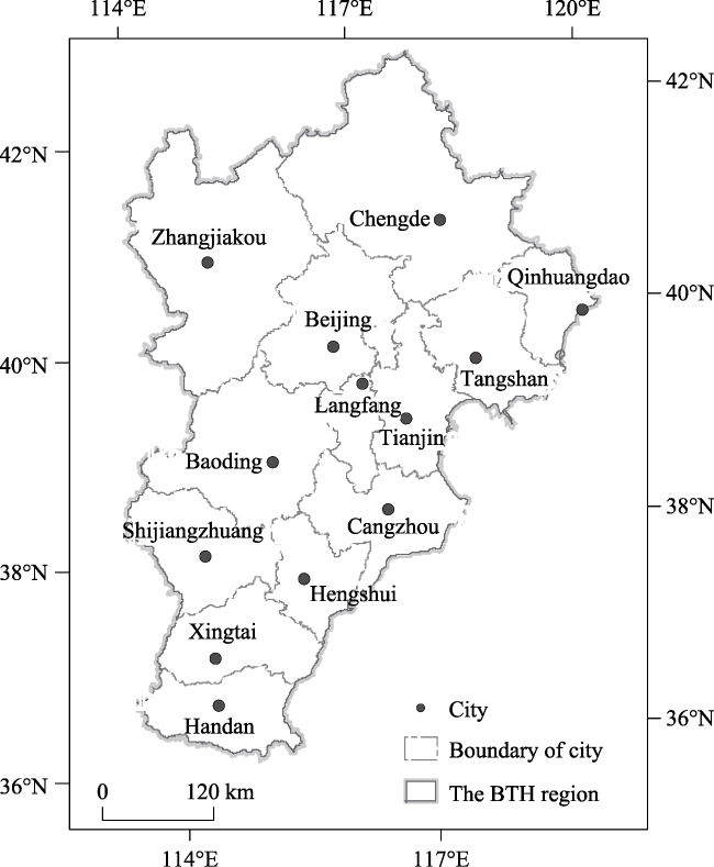
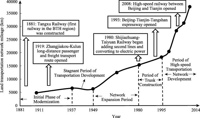
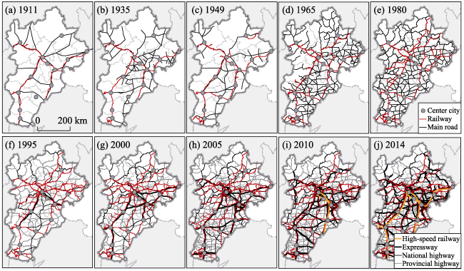
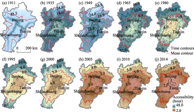
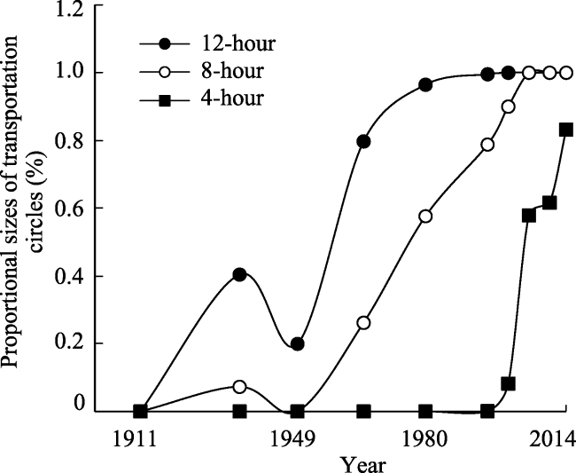
From the development of modern transportation to the current era of high-speed transportation networks, the Beijing-Tianjin-Hebei (BTH) region has always played a national leading role in land transportation development of China. In order to explore the long-term evolutionary characteristics of land transportation in the BTH region, this paper utilized a temporal scale of 100 years to systematically interpret the development process of the land transportation network. Taking 13 cities within the BTH region as research anchor cities, we took into account “leaping” mode of transportation in order to investigate the evolution of accessibility. Our research shows the following results: (1) The land transportation network in the BTH region has undergone five stages of development: the initial period of modernization (1881-1937); the period of stagnation of transportation development (1937-1949); the network expansion period (1949-1980); the period of trunk construction (1980-1995), and the period of high-speed transportation network development (1995-present). The network structure centered around Beijing has existed from the outset of modern transportation development. (2) The accessibility spatial pattern of land transportation in BTH region has evolved from expansion along traffic corridors to the formation of concentric circles. The stratified circular structure of transportation in anchor cities has gradually developed into a contiguous development pattern. (3) There are clear hierarchical differences in the transportation structures of anchor cities. Beijing has always been at the top of this hierarchy, while the hierarchical position of Zhangjiakou has fallen noticeably since 1949. The Beijing-Tianjin region was the first region to form a short-duration transportation circle structure, while the transportation advantages of the central part of Hebei Province, which is located in the center of the BTH transportation region, have yet to be realized.

Cite this article

CHEN Yu , JIN Fengjun , LU Yuqi , CHEN Zhuo , YANG Yu . Development history and accessibility evolution of land transportation network in Beijing-Tianjin- Hebei region over the past century[J]. Journal of Geographical Sciences, 2018 , 28(10) : 1500 -1518 . DOI: 10.1007/s11442-018-1558-x

1 Introduction

The construction of land transportation networks fundamentally supports the process of regional socioeconomic development. This is especially true in economically developed regions, where expansion and development are highly dependent upon transportation links between small and major cities within the region. For this reason, research regarding the development and accessibility of land transportation networks at the metropolitan scale has become popular. At present, most studies under this scale can be summarized in three main aspects. 1) Agglomeration effect caused by a specific arterial transportation line. These studies are mostly in sights of employment, land utilization and travel behavior in relative microscale (Bruinsma et al., 1993; Gutiérrez and Gómez, 1999; Ross, 2011; Song et al., 2012). 2) Agglomeration effect caused by a single mode of transportation. These researches focus on the accessibility changed by the railway network or high-speed railway network only, road network or expressway only (Sasaki et al., 1997; Kim, 2000; Chang and Lee, 2008; Sánchez-Mateos et al., 2014). 3) Development and accessibility of comprehensive transportation network. Many researches for regional planning are based on the comprehensive transportation network. As for China, studies regarding comprehensive transportation networks at the metropolitan scale tend to emphasize three highly developed regions because the development of agglomeration regions has become a national strategy. The works (Chen and Lu, 2008; Fan, 2008; Yang et al., 2014; Chen and Jin, 2016; Zhou Kai et al., 2016) study the accessibility of municipal areas in the Beijing-Tianjin-Hebei region (BTH). And some studies investigate the evolution of accessibility in the Yangtze River Delta region (Zhang and Lu, 2006; Wu et al., 2006; Chen, 2013). Additionally, some researchers are focused on the evolution of the Pearl River Delta region transportation network (Cao and Yan, 2003; Li and Cao, 2011; Hou and Li, 2011), while numerous efforts have been made to conducts in-depth research on the transportation network of the Wuhan metropolitan area (Liu et al., 2009). Furthermore, Song et al. (2016) conduct a comparative study of metropolitan areas throughout China. However, the temporal scale of most relevant studies is limited to 10-20 years. Even though conducting a long time series of studies on the development of national-scale road networks is of great significance (Jin and Wang, 2004; Axhausen et al., 2011; Germà, 2011; Wang et al., 2016) such studies of metropolitan-scale road networks are relatively few.
The BTH region is one of China’s most important areas with regard to concentrations of population and industries, and has generated large volumes of flow in passengers and goods. In 2015, 0.11 billion people and 6647.45 billion RMB GDP gathered in this region, and the density of land transportation reached a level three times higher than the national average. There exists a complex system that includes a variety of transportation and shipping modes, including high-speed rail, ordinary rail, highways, national highways, and provincial highways. The construction and improvement of transportation networks can bring spatio-temporal convergence effects to regions, thereby affecting regional economic development, industrial layouts, and spatial structures. The relationship between road network distribution and regional development is a long-term process of mutual evolution. In view of the history of transportation development, ever since the initial period of China’s modern industrial development, the development of the BTH region’s land transportation network has occupied a leading position. The BTH region is home to China’s first independently constructed railway, first electrified railway, first highway, and first high-speed railway. Research on transportation networks in the BTH region can be traced to the Beijing-Tianjin-Tangshan National Land-Use Plan in the late 1980s, and Wu Liangyong’s BTH Regional Urban-Rural Spatial Development Plan in the 1990s (Wu, 2000, 2002). The BTH region is distinct from other metropolitan areas in that it is a classic example of a metropolitan area centered around an especially large and regionally centralized capital city. The status of the capital enables the land transportation network to have a unique spatial organization pattern. Furthermore, at the outset of China’s modern transportation age in the late Qing Dynasty (1881-1911), Beijing was not only China’s capital, but also its most important transportation hub. Throughout historical evolution, the administrative area of the BTH region has maintained a certain degree of unity. Its road network has exhibited a historical continuity throughout different periods, wherein the relationship of mutual evolution between the construction of road networks and regional development can be traced back more than one hundred years. Currently, given the coordinated development of the BTH region, we conduct a study of regional transportation networks spanning over a century. It is of great practical significance for the unified development of the BTH region to understand the process and principles that govern the evolution of road networks.
In view of this, this paper begins by interpreting the history of the development of the land transportation network in the BTH region, starting from the emergence of modern transportation development. This interpretation is conducted in historical context and through distinct stages of scalar road development. It further summarizes the factors driving the different stages of transportation network development. Simultaneously, a time-distance model is utilized which takes into account “leaping” modes of transportation to investigate the evolution of accessibility in these transportation networks, and analyze the historical evolution of average regional travel times and developmental differences between the transportation circles of different anchor cities. Finally, the paper summarizes the orientation and characteristics of the phases of evolution of the effect of spatio-temporal convergence in this region.

2 Methodology

2.1 Data sources

The study area BTH is located in North China, with flatlands in the east and high terrain in its northwest (mountain area accounts for 46.1%), surrounded by the Yanshan Mountains, Taishan Mountains, and Bohai Sea ports as Huanghua, Tianjin, Tangshan and Qinhuangdao which are large sea ports of China are gathered in the east coast of BTH. The location advantages in the east and natural conditions in the west play a great role to the development of land transportation network in BTH. In order to conduct a comparative analysis of the history and characteristics of the evolution of the transportation network, this paper uses the BTH region’s administrative divisions of 2014 as its standard spatial boundaries. These include municipalities of Beijing and Tianjin, and Hebei Province, while anchor city nodes include the 13 cities of Beijing, Tianjin, Shijiazhuang, Langfang, Baoding, Tangshan, Qinhuangdao, Chengde, Cangzhou, Hengshui, Handan, Xingtai, and Zhangjiakou (Figure 1).
Figure 1 Location of the Beijing-Tianjin-Hebei region
According to the context of periodic development, we have determined ten time nodes within the past century; they are 1911, the final year of the Qing Dynasty (including carriagewaysfor official business and ordinary railways); 1935, prior to the outbreak of the Second World War during the Republican era (including trunk roads and ordinary railways); 1949, the end of the civil war and the founding of the People’s Republic of China (PRC) (including arterial highways and ordinary railways); 1965, the beginning of the Third Front Movement (including arterial highways and ordinary railways); 1980, the beginning of the period of reform and opening (including arterial highways and ordinary railways); 1995, 2000, and 2005, periods of rapid development in industrialization and urbanization (including expressways, national and provincial trunk roads, and ordinary railways); and 2010 and 2014 (including expressways, national and provincial trunk roads, ordinary railways, and high-speed railways).
Road network data is primarily sourced from atlas vectorization, including the China Public Road Transportation Atlas (1935), Railway Development History in China (1876-1949), A Brief History of Chinese Railway Architecture (1881-1981), Atlas of Hebei Province (1981), Atlas of China (1966), the China Transportation and Tourism Atlas (1996 and 2001), and the Provincial Atlas of the People’s Republic of China (1995).

2.2 Model for assessing time accessibility

Hansen (1959) first proposed the concept of accessibility. It is typically argued that accessibility refers to the degree of difficulty with which one can reach a given point in a transportation system. Based on the objectives of different studies, accessibility models have primarily included distance accessibility, based on the cumulative probability of accessibility; and distance attractiveness, based on spatial interaction. This paper adopts a time-distance accessibility model, which calculates the average travel time for transportation circles and overall regions for each anchor city.
The need for accessibility to railways and expressways makes transportation networks highly dependent upon railway stations and expressway exits. In some places where the areas between railway stations or expressway exits are closed off, they are not necessarily directly accessible, even if a transportation artery exists. For this reason, errors will result if calculations are made only according to the highway grid. This is especially true in periods since the emergence of expressways and high-speed railways, where such errors will be extremely evident. Railways and expressways must be distinguished from ordinary highways, and a combination of network analysis and raster data structures should be used to conduct time-distance accessibility calculations that take into consideration large leaps in forms of transportation. The specific steps for this method are as follows:
(1) Divide the area into several grids of 1 km×1 km. Since transportation within cities is not being considered, 1km2 grids are sufficient to precisely reflect the transportation characteristics of the overall area of the region.
(2) Confirm the transit speed of each level of railway and highway, specific assigned values of which are listed in Table 1.
Table 1 Speed assignments on roads and railways (km/h)
Year Railway Highway Default
High-speed railway Ordinary railway Expressway National highway Provincial highway Blank regions
1911 / 30 / 4 2
1935 / 35 / 30 5
1949 / 43 / 30 5
1965 / 45 / 40 10
1980 / 50 / 40 10
1995 / 50 90 60 40 20
2000 / 60 100 80 60 20
2005 / 70 100 80 60 30
2010 300 100 100 80 60 30
2014 300 120 100 80 60 30

* Speeds are determined primarily in the following manner: at the end of the Qing Dynasty, there were mostly dirt or brick roads that were primarily used by animal-drawn carts or rickshaws. As such, the 4 km/h speed value for these roads is assigned based on the speed at which such carts travel. A report on the Tangxu Railway states that, “The Rocket of China which uses a steam locomotive is filled with visitors and local officials, and travels at a speed of more than 30 km/h for round-trip journeys.” Based on this, a railway speed of 30 km/h is assigned. As of 1935, motorcars were able to reach speeds of 40-60 km/h, while carts (both animal-drawn and rickshaws) could travel 40-50 km/day. At that time, China had about 50,000 cars, and most vehicles on highways were carts, a highway speed of 30 km/h is assigned. At this period, railway speeds were 32-45 km/h. The above description about speed setting is based on some historic studies (Bureau of Roads National Economic Council, 1936; Su, 2014). There is no data for highway travel speeds for the initial period after the founding of the PRC. However, based on the level of construction for roads at that time, we assign the same values as those in the Republican period. In 1958, vehicular speeds on arterial highways could typically reach around 40 km/h (Tang, 1959). Since the development of highways remained stagnant between 1958-1965, the same highway speed is assigned for 1965. Subsequent highway speeds are primarily assigned according to the People’s Republic of China Industry Standards - Highway Route Design Code, and actual conditions. Railway speeds are assigned according to the railway speeds at the initial period of the founding of the PRC and each speed increase in the seven rounds of the Campaign to Raise the Speed of Railway Travel in China.

(3) Convert highways (excluding expressways) into 1 km×1 km raster grids. Since lower levels of roads can still access areas not served by highways, the default speed is set for the entire region’s raster. Overlay highway raster images (excluding expressways) with default raster value for the entire region in order to obtain maximum values.
(4) Generate a point sequence composed of railway stations and expressway entrances and exits, Si (i=1, 2, 3…, n), and derive the time cost, tgi, for travel from anchor city g to Si (i=1, 2, 3…, n).
(5) Utilize the cost weighted distance method to derive the minimum time for travel from anchor city j to raster j, tgj, and from point set Si (i=1, 2, 3…, n) to raster j, tij.
(6) Derive Tgj=min {tgj,tgi+tij}. Calculate the shortest travel time from anchor city g to raster j.
After iterating the above steps and making calculations for all 13 anchor cities, calculate the average values for each raster layer, derive a distribution diagram for average travel time in the entire region, and assess overall regional accessibility. By using overlays to attain minimum values, extract the spatial pattern of transportation circles for anchor cities in the BTH region according to a time hierarchy.

3 Expansion of land transportation network in the BTH region

By interpreting the construction history of railways and highways in the BTH region, and by calculating the mileage of road networks (including railway mileage and national and provincial arterial highway mileage), combined with the development process of road networks, we distinguish between the following five periods in the development of the BTH region transportation network (Figure 2).
Figure 2 Changes in mileage and divisions of development stages of the land transportation network in the Beijing-Tianjin-Hebei region
3.1.1 Initial Phase of Modernization (1881-1937)
From the late Qing Dynasty, there was a campaign for modern industrialization in imperial China. In addition, the pace at which resources like iron and coal were mined and exported was increased, promoting the construction of modern railways. In 1881, the first railway in the BTH region, the “Tangxu Railway” was constructed, creating preconditions for modernization of transportation in the region. Subsequently, a rail network was constructed, making it convenient to ship mined resources. The network included the Jingfeng Railway (Kailuan Coal Mine), the Zhengtai Railway (Zhengfeng Coal Mine), the Jingsui Railway (Yihua Coal Mine), and so on. The construction of modern highways in the BTH region occurred more than 20 years after railways were constructed. In 1919, with the opening of the Zhangjiakou-Kulun long-distance passenger and freight transport route, long-distance automobile freight transport began in China (Su, 2014). In the late Qing Dynasty, 83.3% of Chinese railways transited directly through Beijing, though modern highways had not been constructed on a large scale, and road network trunks were composed of carriageways for official business. This indicated that the road network formed a radiating spatial pattern with Beijing at its center (Figure 3a). The central status of the capital city has a relatively large impact on the construction speed and spatial distribution of the road network. The “hub and spoke” model for railway networks was formed in the late Qing Dynasty and the Beiyang Government period, during which Beijing was the capital. During the Republican era, Nanjing served as the capital, and the influence of Beijing as a capital declined. Rail network construction in the BTH region slowed. However, coastal highway construction around Tianjin was spurred on due to Tianjin’s qualities as a port city. At the same time, because of technical limitations in road network construction, the natural environment significantly affected the network’s distribution. Given the influences of industrialization and natural geographical conditions, the development of road networks in the region shifted eastwards. As of 1935, during the initial development period of modern transportation in the BTH region, a network was formed with Beijing as its center. Main trunks ran between Beijing and Shijiazhuang, Beijing and Zhangjiakou, Beijing, Tianjin, and Tangshan, and between Tianjin and Cangzhou. This formed a preliminary land-transportation network centered around the eastern regions (Figure 3b), and profoundly affected the evolution of transportation networks in the BTH region.
Figure 3 Spatial pattern evolution of the land transportation network in the Beijing-Tianjin-Hebei Region from 1911 to 2014
3.1.2 Stagnant Period of Transportation Development (1937-1949)
With the outbreak of war, political restrictions slowed construction work on the transportation network in the BTH region. During this period, railways and highways were primarily constructed to ship military goods for the war. Neither the government, nor businesses or western powers had the capital or energy to invest in construction of transportation infrastructure. The Japanese Army incorporated the BTH region’s railway into the Manchurian railway monopoly system. They used the railway to transport coal, iron ore, bauxite, cotton, salt, and other goods to Japan (Jin and Xu, 1986). At the same time, Japan forced conscripted laborers to construct roads for the purpose of security (Su, 2014). After the end of the Chinese War of Resistance Against Japanese Aggression (1945), the Soviet army, the Japanese army, and the Chinese nationalist Kuomintang army destroyed some railways. Most Japanese roads that were built for security purposes were abandoned, and only a small portion of these were converted into official highways. Compared to the period prior to the war, the spatial distribution of the road network had not been noticeably expanded. Not only had the mileage of the road network not increased, it had decreased slightly (Figure 3c).
3.1.3 Network Expansion Period (1949-1980)
The implementation of regional policies was one of the primary drivers of construction of the land transportation network in the BTH region during this period. The Third Front Movement expanded investment in the construction of basic infrastructure, and affected road network construction in the western part of the BTH region. In the initial period after the founding of the PRC, the focus of construction of the transportation network in the BTH region centered on restoration of existing railways and highways, and the mileage of the road network increased significantly. Between 1949-1965, China’s operational railway mileage increased from 1944 km to 2568 km, while the highway mileage reached 29,787 km in 1965. However, the density of the road network in the western part of the BTH region was significantly lower than that of the eastern area. Beginning in 1964, China implemented the Three Front Movement, and opened arterial transport routes such as the Beijing-Yuanping Railway and the Jingtuo Railway, in addition to beginning construction on other arterial routes like the Beijing-Tongliao Railway and the Handan-Changzhi Railway. The western part of Hebei Province was home to the Third Front Movement construction, where the highway network expanded rapidly, with mileage reaching 50,901 km. Transportation routes continued to expand westward. The distribution of trunk highway networks exhibited greater balance, and the variation between the densities of road networks in the eastern and western parts of the region was reduced, thus basically establishing the balanced development patterns in which each county contained trunk route access (Figure 3e).
3.1.4 Period of Trunk Construction (1980-1995)
With the background of reform and opening, industrialization and urbanization brought about by regional development policies served as the primary driver of road network expansion during this period. China amended its balanced development strategy in favor of one that prioritized development of eastern coastal regions, in which the BTH region occupied an advantageous position. In tune with accelerated industrialization and urbanization in the BTH region, the development of transportation networks ushered in new large-scale construction and upgrading works. With regard to establishing the distribution of China’s rail network, an emphasis was placed on shipping coal from western China to eastern China, and gas from eastern China to western China in order to satisfy eastern China’s demand for raw materials and energy. In the BTH region, railway trunk routes such as the Shijiazhuang-Dezhou Railway, the Beijing-Guangzhou Railway, the Beijing-Baotou Railway, and the Shijiazhuang-Taiyuan Railway began adding second lines and converting to electric power. At the same time, following the opening up of a route between Beijing and Chengde in the previous stage, additional trunk routes were constructed, including the Beijing-Qinhuangdao Railway and the Datong-Qinhuangdao Railway, which directly allowed access to the Beijing-Tangshan route, without needing to pass through Tianjin in order to reach Tangshan or Qinhuangdao. With regard to highways, the National Trunk Highway Network Plan (Trial Project) was implemented in 1981, and established strict regulations for national highways and provincial highways. In addition, 12 national highways were established radiating from Beijing in five directions towards Shijiazhuang, Zhangjiakou, Chengde, Tangshan, and Tianjin (Figure 3f), constructing land transportation network trunks centered on Beijing. This formed a hub-and-spoke road network with Beijing as its center.
3.1.5 Period of High-Speed Transportation Network Development (1995-present)
Stimulated by the progress of industrialization and urbanization, the influence of the capital’s status, and the promotion of upgraded infrastructure construction technology, the land transportation network of the BTH region entered a phase of conversion to high-speed networks. With the continuous expansion of industrial distribution, a phenomenon emerged in the BTH region in which highways and railways interacted to transport goods. Between 2005 and 2013, goods shipped by rail in the region decreased from 18.9% to 12.2%, while goods shipped via highways increased from 79.6% to 87.1%, indicating the increasing demand for construction of optimized transportation networks. At the same time, the BTH region is an important area of population concentration in China, and is responsible for the flow of a large volume of passengers and goods. Rapid increases in population and the rapid development of motorized transport resulted in socioeconomic development in the BTH region. This in turn caused the role of the transportation network to be guided by factors of industrialization, as had been the case since the period of reform and opening. Over time, there was a gradual shift in dominance to urbanization factors. Given this background, the Beijing-Tianjin-Tangshan expressway opened in 1993, becoming China’s first operational expressway. Subsequently, the expansion of expressways accelerated, with the addition of an average 838 km to the region’s networks each year between 1995 and 2014. Consequently, the mileage of the network reached 7982 km in 2014. China’s first high-speed railway between Beijing and Tianjin opened in 2008, and as of 2014, there were five high-speed railways in the BTH region. Because of Beijing’s status as China’s capital city, a new round of construction commenced for national high-speed transportation networks centered on Beijing. Seven expressways were constructed emanating from Beijing, extending in the three directions from Beijing towards Shijiazhuang, Tianjin, and Tangshan via Tianjin, respectively. The BTH region, which has established itself as a global metropolitan area, is currently engaged in rapid construction and improvement of its high-speed land transportation network, and reversing the circumstances of early transportation modernization efforts that existed one century ago.
In view of the history of the BTH region’s transportation network development over the past century, the core factors affecting the construction and distribution of road networks can be summarized as follows: Construction and distribution were principally driven by the status of the capital, promoted by the progress of industrialization and urbanization, and by the implementation of regional development policies, while they were restrained by technological progress and political factors. However, the main driving factors varied at different stages of development. The BTH region is a metropolitan area with Beijing, the capital, serving as an especially large anchor city. The absolute nature of Beijing as the political center of the BTH region has a profound effect on the distribution of trunk roads or major routes. This is the unique nature of this influencing factor. In the BTH region, most trunk routes are not constructed for internal regional demand, but have been built in response to the need for major roads with access to Beijing, on a national spatial scale. The determining factor influencing the evolution of the structure of the land transportation network in the BTH region is not socioeconomic development on a regional scale, but rather optimization of transportation patterns on a greater regional scale. This principle has made it such that Beijing serves as the absolute center of the BTH region’s basic hub-and-spoke type road network. Simultaneously, the road network is severely affected by geographical restrictions. Access to national-scale transportation routes promotes the improved status of regional transportation districts, and developing cities, in addition to influencing the decline of traditional water-based shipping methods, and gradually altering the pattern of transportation linkages in the BTH region. Given this background, the structure of the road network in the BTH region has developed from a hub-and-spoke model with a few radiating trunk roads, to a dense network. Furthermore, the density of the eastern coastal region transportation network is significantly higher than that of the western and northern parts of the region, although this difference is gradually declining, forming a high-speed transportation network radiating from Beijing at its center. In this network, ordinary rail networks and national highway networks connect each county while the dense networked layout structure of provincial highways offers uniform coverage.

4 Accessibility evolution of land transportation in the BTH region

4.1 Spatial patterns of average regional journey time

The spatial pattern of average travel time to reach the 13 anchor cities in this region are shown in Figure 4. These results illustrate that as the transportation network has developed, average accessibility in the BTH region has increased significantly, as its spatial pattern has gradually evolved from a corridor design, to a concentric circle structure. In the early period of modern transportation development, accessibility expanded outwards from the axes between Beijing and Zhangjiakou, Beijing and Shijiazhuang, and Beijing and Tianjin. This accessibility structure exhibited corridor convergence characteristics. As the density of the transportation network has increased consistently, a concentric circle structure has gradually formed, expanding both inwards and outwards from its structural center between Beijing and Tianjin. However, recent short-travel direct routes have formed a distinct structure of expansion moving along traffic corridors.
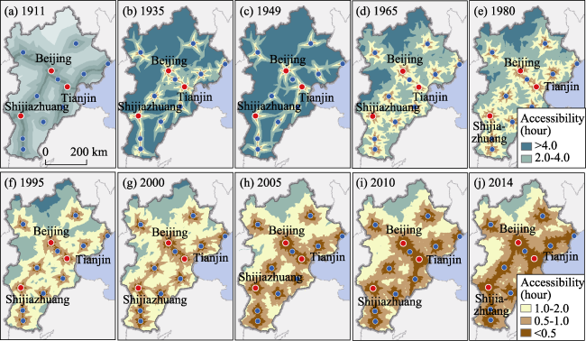
Figure 4 Spatial evolution of the accessibility of the land transportation network in the BTH Region from 1911 to 2014
Specifically, the evolution of the spatial pattern of regional average travel time has distinct periodic and orientation characteristics:
1. The spatio-temporal convergence effect brought on by the development of land transportation in the BTH region is evident, and the process of evolution in the transportation networks exhibits a distinct periodic nature. In the initial period of modern transportation development, only areas surrounding transportation trunks could reach anchor cities in less than 24 hours, with the region’s average accessibility being 42.3 hours. As of 1949, the scope of areas with anchor city accessibility under 24 hours expanded 4.6 times, and 79.7% of the region was able to access anchor cities within 12 hours. Figure 5 shows that from 1911 to 1965, the scope of areas in the BTH region that could access anchor cities within 12 hours expanded relatively rapidly, and by 1980 the region’s average accessibility reached 7.8 hours. The 8-hour transportation circle expanded to cover 57.6% of the region, up from 26.2% in 1965. By 2000, the region’s average accessibility was 5.9 hours, with the 8-hour transportation circle covering 90% of the region’s area. After 2000, short-duration transportation circles expanded rapidly, and as of 2014, the region’s average accessibility time was reduced by 3.1 hours, 5.4 times faster than in the period after the establishment of the PRC. Furthermore, the 4-hour transportation circle, which covered 8.2% of the region’s area in 2000, increased to 83.2% of the region in 2014. These improvements are especially apparent in central areas, where accessibility times declined from under 5 hours to less than 3 hours. The Beijing-Tianjin region has a 2-hour ring structure, and is the region’s most accessible area.
Figure 5 Changes in the proportional sizes of transportation circles in the Beijing-Tianjin-Hebei Region from 1911 to 2014
2. Areas with advantageous accessibility have gradually shifted towards the east, in a spatio-temporal convergence effect evolution that exhibits distinct directionality. In view of the evolution of average accessibility contours in the initial period of the land transportation network’s development, the pattern of accessibility expanded along routes from Beijing at the center towards Zhangjiakou, Shijiazhuang, Tianjin, and Cangzhou. However, transportation accessibility in the direction of Chengde from Beijing was relatively poor, illustrating that the northwestern region of Chengde had the poorest regional transportation linkages. With the development of eastern coastal areas, the construction of modern highways brought significantly improved accessibility to the Tianjin-Tangshan region. As of 1935, accessibility in coastal areas like Tangshan-Tianjin-Cangzhou increased by 65.9%, while accessibility of the Baoding-Shijiazhuang region increased by 58%. During the wartime period of transportation development stagnation, industrial development was difficult, and the progress of accessibility expansion was slow. After the founding of the PRC, expansion of regional accessibility accelerated, although the area contained by the average accessibility contour for Beijing-Shijiazhuang exhibited significant change compared to the initial period of transportation modernization. The regional status of road network accessibility for the Zhangjiakou area declined, becoming significantly lower than accessibility between Beijing and Shijiazhuang, or between Beijing and Tianjin. After the period of reform and opening, given the background of accelerated industrialization and urbanization in eastern coastal areas, the tendency for eastern regions to have advantageous accessibility became more apparent. Combined with the effects of factors such as natural geographic conditions and socioeconomic demands, there were no significant breakthroughs in terms of transportation connectivity between the entire region and the Beijing-Zhangjiakou or Beijing-Chengde transportation routes.

4.2 Spatial patterns of anchor city transportation circles and variation in evolutionary characteristics

By calculating travel time for routes between anchor cities and any location in the region, we can derive transportation circles for our 13 anchor cities. By overlaying these and extracting minimum values, we can derive the spatial patterns for anchor city transportation circles in the BTH region (Figure 6). Generally speaking, accessibility for each anchor city in the BTH region has experienced significant improvement. Development patterns have gradually shifted from traffic corridors to contiguous short-duration transportation circles. Anchor cities’ contiguous short-duration transportation circle patterns have important practical significance for the unified development of the region.
Figure 6 Spatial layout evolution of anchor city transportation in the Beijing-Tianjin-Hebei region from 1911 to 2014
In view of the spatial pattern of anchor cities’ transportation circles (Figure 6) and statistics regarding changes in the proportions of areas covered by transportation circles (Figure 7), the process of anchor city transportation circle development exhibits distinct periodic characteristics: (1) In the initial period of modernization, transportation circles of each anchor city had a distinct structure extending from trunk routes, where the scope of accessibility between regions did not form contiguous coverage. Furthermore, the transportation circles for Chengde and Hengshui did not exhibit corridor effect characteristics, but rather a concentric circle structure that had poor links with the transportation networks of other cities. In 1935, in the small area between Beijing, Tianjin, and Tangshan, contiguous coverage of 4-hour transportation circles emerged, forming the strongest and most central area of transportation network linkages. As of 1949, more than one half of the region remained outside of the scope of the 4-hour transportation circle, though these circumstances greatly improved by 1965, when 81.7% of the region could reach their nearest anchor city within four hours.
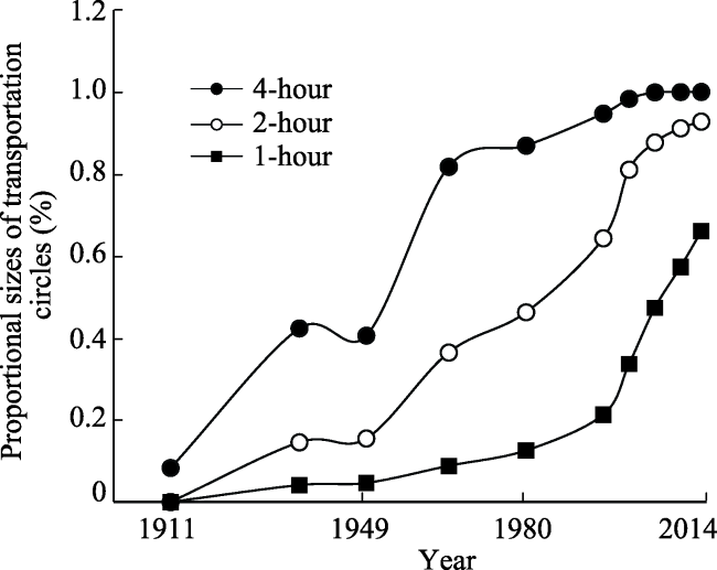
Figure 7 Variations in the proportion of areas covered by the transportation circles of BTH region anchor cities from 1911 to 2014
(2) After 1965, 2-hour transportation circles began to expand rapidly. The first area to achieve contiguous 2-hour traffic circles was the Beijing-Tianjin area, after which such transportation circles strengthened continuously along the routes between Beijing and Shijiazhuang as well as Beijing and Tangshan. Hengshui’s transportation circle also expanded continuously, and Hengshui’s links with Shijiazhuang and Cangzhou strengthened gradually. However, the transportation network linkages between Beijing and Zhangjiakou weakened, with the development of contiguous transportation circles connecting Zhangjiakou and Chengde to Beijing developing relatively slowly. As of 2000, the area covered by 2-hour transportation circles reached 81%, up from 36.4% in 1965.
(3) Between 2000 and 2014, there was significant expansion of 1-hour transportation circles in anchor cities. As of 2014, such circles extended over large contiguous areas, covering 66% of the region’s area. Half-hour transportation circles illustrate the distinct “high-speed rail convergence effect,” and are characterized by expansion along high-speed rail transit corridors. Centered on Beijing and moving along the Beijing-Tianjin route, Langfang, Tianjin, and Cangzhou first formed a contiguous area of short-duration transportation circles. Subsequently, with the influence of high-speed transportation development, complete coverage of 1-hour transportation circles was achieved for Baoding, Shijiazhuang, Handan, and Xingtai along the Beijing-Shijiazhuang route. Although Tangshan and Qinhuangdao along the Beijing-Tangshan route have developed contiguously with the Beijing-Tianjin region, because of the low accessibility between the central Hebei province, this area is encircled by Tianjin, Langfang, Beijing, and Baoding, and should be completely covered by an anchor city’s short-duration transportation circle. However, the transportation corridors between Tianjin and Baoding as well as Cangzhou and Shijiazhuang make it such that this area is not yet covered by an anchor city’s one-hour transportation circle.
In view of the process of development, the service scope growth of the transportation circles for the 13 anchor cities is generally consistent (Figure 8), and the expansion processes are synchronous. While the pace of expansion was slow between 1911 and 1949, it grew stably between 1949 and 2000, and expanded rapidly between 2000 and 2014. In reality, the pace of expansion for each anchor city’s transportation circles varied during different periods. Viewing the same time period, the scope of each anchor city’s transportation circle coverage varied. Specifically:
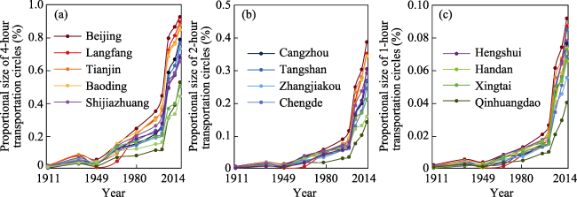
Figure 8 Variations in proportions of transportation circle coverage for respective anchor cities in the BTH Region from 1911 to 2004
In 1911, the structure of transportation circle formation was centered at Beijing, Tianjin, and Shijiazhuang, while traffic circle development in Chengde and Hengshui was relatively poor. The areas covered by Beijing’s 4-hour and 2-hour transportation circles were 19.9 and 24.9 times greater than those of Hengshui, respectively. Because of the stimulus of modern industrial development, as of 1949, the speed of transportation circle expansion for Beijing, Tianjin, Zhangjiakou, Tangshan, Shijiazhuang, and Handan were higher than average, with this expansion focused around the Beijing-Tianjin-Tangshan, Beijing-Zhangjiakou, and Beijing-Shijiazhuang corridors. However, Qinhuangdao and Langfang’s transportation circles covered relatively small areas. The areas covered by Beijing’s 4-hour and 2-hour transportation circles were 9.8 and 10.5 times greater than those of Langfang. Between 1911 and 1949, the transportation circles of anchor cities like Beijing, Tianjin, and Tangshan expanded to cover relatively large areas, while the area of expansion of traffic circles for Langfang and Xingtai was relatively small. In addition, these transportation circles were fundamentally weaker and underdeveloped.
After the founding of the PRC, China experienced road network expansion and trunk road construction. By 2000, the areas covered by the transportation networks of each anchor city varied, forming a structure where Beijing, Tianjin, Langfang, Baoding, and Shijiazhuang’s networks covered the greatest area, and Zhangjiakou and Qinhuangdao covered the least area. Beijing’s 4-hour, 2-hour, and 1-hour transportation circles cover areas 3.9, 3.3, and 2.6 times greater respectively than those of Qinhuangdao. The difference in sizes of these cities’ transportation circles has declined significantly since 1949. From 1949 to 2000, the 2-hour transportation circles of anchor cities such as Beijing, Tianjin, Baoding, and Langfang have expanded by the greatest area, while those of Handan, Zhangjiakou, and Qinhuangdao have expanded by relatively smaller areas. During the process of development between 1911 and 1949, Zhangjiakou, being located on a trunk route in the northwestern direction, ranked highly in terms of the scope of its transportation circles. However, after the founding of the PRC, its status fell noticeably, while the scope of transportation circles for Baoding and Langfang expanded significantly, as they were advantageously located along the Beijing-Shijiazhuang and Beijing-Tianjin routes.
With the rapid development of high-speed transportation, the transportation circles for each anchor city have expanded rapidly. As of 2014, in terms of the areas covered by their transportation circles, Beijing, Tianjin, and Langfang ranked highly, while Zhangjiakou, Chengde, Handan, and Qinhuangdao ranked poorly. In 2014, the area of the 2-hour transportation circle covered by Beijing was 2.7 times larger than that of Qinhuangdao, while its 1-hour transportation circle covered an area 2.3 times larger than that of Qinhuangdao. This variation had declined since 2000. Benefited by the development of high-speed rail, the 4-hour transportation circles of all anchor cities cover more than 40% of the entire area of the region on average, while the 4-hour transportation circles of Beijing, Tianjin, Langfang, and Baoding cover more than 80% of the area of the BTH region. The 1-hour transportation circles of anchor cities located along the Beijing-Tianjin-Tangshan corridor, such as Beijing, Tianjin, Langfang, and Tangshan have expanded by the largest area, while those of Zhangjiakou and Chengde, on the Beijing-Zhangjiakou and Beijing-Chengde routes have expanded by relatively smaller areas, and are comparatively underdeveloped in this regard.

5 Summary and discussion

5.1 Summary

The BTH region is an area of significant population and industrial agglomeration within China, in addition to being a traditional metropolitan area centered around a capital city. The characteristics and principles by which the region’s land transportation network has developed have served as breakthroughs for the region’s coordinated development, while research regarding its land transportation network has important practical and theoretical value. In this paper, we consider the unified development of land transportation in the BTH region from a historical and geographical perspective, since the outset of modern transportation development. For this reason, we trace relevant developments to more than 100 years in the past, observing the principles guiding the development and accessibility evolution of land transportation in the BTH region since the beginning of railway operations in the region. By considering it against the background of mileage and developmental periods for road networks, this paper distinguishes between five stages in the century-long history of the development of the BTH region’s transportation network: the initial period of modernization (1881-1937); the period of stagnant transportation development (1937-1949); the network expansion period (1949-1980); the period of trunk construction (1980-1995), and the period of high-speed transportation network development (1995-present). The following five types of factors have principally influenced this century-long process of development: the status of the capital city, the development of industrialization and urbanization, regional development policies, technological innovations, and political factors. During different periods of development, each of these factors has exerted different effects on the development of the transportation network. Herein, the status of the capital plays a decisive role in the basic structure of the BTH region’s road network, especially with regard to the emergence of a “hub-and-spoke” pattern of trunk roads. A prototype for this type of road network was formed early on in the process of modernization of transportation.
In order to understand the “qualitative” effect of the road network’s “quantitative” mileage expansion on regional accessibility, this paper has used a combination of network analysis and raster calculation, and employs a time-distance accessibility model to analyze the evolution of the spatio-temporal convergence effect in the region over the past century. Our primary conclusions are as follows:
(1) With the development of its transportation network, the average level of accessibility in the BTH region has increased significantly, while the spatial pattern of the transportation network has gradually changed from one in which expansion occurs along transportation corridors, to a concentric circle structure. The process of change in the spatio-temporal convergence effect exhibits distinct directionality. In the initial period of transportation modernization, expansion occurred outwards from the center of Beijing along the following routes: Beijing-Zhangjiakou, Beijing-Shijiazhuang, Beijing-Tianjin-Tangshan, and Beijing-Tianjin-Cangzhou. However, transportation accessibility towards Chengde from Beijing was relatively weak. Subsequently, the relative status of road network accessibility for the entire region along the Beijing-Zhangjiakou route declined, while the accessibility advantages of regions lying in easterly directions of Beijing became apparent.
(2) Expansion of the transportation circles of each anchor city occurred initially along traffic corridors, though this development pattern gradually transformed into one in which expansion occurred through the development of contiguous short-duration transportation circles. The BTH region has always lead the way in the formation of short-duration contiguous transportation circles, though in the initial stage of development, linkages between Hengshui and other anchor cities were relatively weak. As road networks have been constructed, and Hengshui’s transportation circles have consistently expanded, its linkages with Shijiazhuang and Cangzhou have gradually strengthened while transportation network linkages between Beijing and Zhangjiakou have weakened. There are variations between the coverage of each anchor city’s transportation circle and pace of expansion. With the construction of transportation networks, variation between the areas covered by transportation circles has gradually declined. As of 2014, there remained visible variation in the scope covered by the transportation circles of anchor cities like Zhangjiakou, Chengde, and Handan, compared to anchor cities such as Beijing, Tianjin, and Langfang. Prior to the founding of the PRC, the area of Langfang’s transportation circle had a relatively small expansion. After the founding of the PRC, however, it was benefited by its advantageous location on the traffic corridor between Beijing and Tianjin, and its transportation circle expanded by a significant degree. The transportation circles of Zhangjiakou and Chengde, however, situated on the Beijing-Zhangjiakou and Beijing-Chengde routes, have expanded by relatively small areas.
(3) In view of the evolution of patterns of the BTH region’s average accessibility and the process of expansion of anchor cities’ traffic circles, both these phenomena exhibit periodic evolutions that are consistent with one another. 1) In the first stage from 1911 to 1965, the average scope of accessibility for 12-hour travel time in the region, and the 4-hour transportation circles of anchor cities both expanded rapidly. From the initial stage of transportation network modernization, the BTH region achieved the construction of the basic foundations of its transportation network in this period. 2) In the second phase between 1965 and 2000, the scope of accessibility for 8-hour travel time in the region and the 2-hour transportation circles of anchor cities both expanded rapidly. The transportation network of the BTH region entered a period of rapid development, and new routes between cities were constructed at an accelerated pace. 3) During the third phase, between 2000 and 2014, the scope of accessibility for 4-hour travel time and the 1-hour transportation circles for anchor cities both expanded rapidly. In this period, the transportation network of the BTH region experienced a process of rapid development, with the emergence of faster routes and consistent network improvements. The periodic nature of the evolution of accessibility reflects the temporal nodes of “qualitative” spatio-temporal convergence effects resulting from the construction of road networks.

5.2 Discussion

Based on the analysis above, we can see that since the beginning of the modernization of transportation and the formation of the prototype structure of the BTH region’s road network, and in the subsequent century of evolution, the structure of the region’s transportation network has not experienced any overwhelming structural transformation. It has simply been the case that the development of transportation in the direction of Zhangjiakou from Beijing has weakened somewhat. The Beijing-Tianjin region has been an area with advantageous conditions for accessibility. Short-duration transportation rings all first appeared in the Beijing-Tianjin region, however, the advantageous transportation positions of the heartland regions encircled by the Tianjin-Langfang-Beijing-Baoding-Shijiazhuang-Hengshui-Cangzhou transportation route have not materialized. This is because, for a long period, the trunk roads of these areas’ land transportation networks have primarily been constructed in response to national-scale road network distribution demands. This has led to Beijing becoming the absolute center of the BTH region, as well as of a hub-and-spoke road network structure. In addition, it has led to the failure of the formation of transportation corridors between other anchor cities, such as Tianjin and Baoding or Cangzhou and Shijiazhuang. The dual-core structure centered around Beijing and Tianjin is acknowledged to be the main engine of development in the area (Tan et al., 2001) and some studies have already proposed the establishment of Shijiazhuang and Cangzhou as an additional dual-core driver of regional development (Lu, 2016). This paper concludes that, given the unified development demands of the region, it is in fact necessary to emphasize the development of a transportation corridor between Shijiazhuang and Cangzhou, in order to improve the patterns of accessibility in these regional centers.
In the process wherein a region develops from having a dispersed pattern of anchor cities to one with a structure of large municipal areas, and further to a large metropolitan area structure, this progression is often dependent upon basic transportation infrastructure developing from only one or two road linkages to the formation of a complex transportation network with hub-and-spoke transportation corridors. While socioeconomic development promotes the construction of transportation networks, the layout of transportation networks guides regional spatial morphology towards the evolution of single-core structures or multi-core structures. In this interactive evolutionary process, the question of whether transportation construction promotes regional development, or whether regional socioeconomic development promotes the construction of basic transportation infrastructure, is a complex one. In view of the century-long evolutionary process of the BTH region’s transportation network, the interactive effects and relationships between these two factors have varied during different phases of development. In the early 1980s, the BTH region was addressed at a strategic level in China’s regional development plan. In the plan’s implementation however, the scope of the space addressed shifted from the Beijing-Tianjin-Tangshan region (including the Beijing, Tianjin, and Tangshan regions) to the Beijing-Tianjin-Hebei Metropolitan Area (including Beijing, Tianjin, and the area of Hebei Province surrounding Beijing) to the Beijing-Tianjin-Hebei Metropolitan Area (including Beijing, Tianjin, and the entirety of Hebei province). Given the background of the coordinated development of Beijing, Tianjin, and Hebei, it is necessary to conduct in-depth discussions of the relationship between the construction of transportation networks in this region and regional development. Previous studies have assessed transportation and shipping or population scales from a regional economic coordination perspective (Liu, 2014; Li and Luo, 2017), but interactive evolution mechanisms require further studies on long-term time scales. This paper only conducts basic research on the evolutionary process of the land transportation network in the BTH region, and offers a simple discussion of the factors influencing this development process. However, it is necessary to conduct further quantitative interpretations of the intensity and methods by which mutual evolution exerts influence, and to explore the characteristics and complexities of transportation network structures and development modes.

The authors have declared that no competing interests exist.

[1]
Axhausen K W, Froelich P, Tschopp M, 2011. Changes in Swiss accessibility since 1850.Research in Transportation Economics, 31(1): 72-80.This paper discusses the changes in Swiss accessibility since 1850 after arguing that such spatially detailed measures are needed, if one wants to understand the impact of transport investment on the economy and land use patterns. The road-based accessibility overtook that offered by the railways around 1930 and has kept a steady relative lead since then. The relative advantage of the large cities has been eroded since 1950 through their population loss and the massive population gain of the metropolitan fringe. In absolute terms, though, they are still locations with the highest accessibilities.

DOI

[2]
Bruinsma F R, Rietveld P, 1993. Urban agglomerations in European infrastructure networks.Urban Studies, 30(6): 919-934.

[3]
Bureau of Roads National Economic Council, 1936. Nanjing: Highways in China, Tables, Charts and Maps.

[4]
Cao X S, Yan X P, 2003. The impact of the evolution of land networks on the spatial structure of accessibility in developed areas: The case of Dongguan City in Guangdong Province.Geographical Research, 22(3): 305-312. (in Chinese)

[5]
Chang J S, Jang-Ho L, 2008. An accessibility analysis of Korean high-speed rail: Case study of Seoul metropolitan area.Transport Reviews, 28(1): 87-103.This paper deals with an accessibility analysis of Korean high‐speed rail. The high‐speed intercity service, which became operational in April 2004, has being creating positive impacts on forming a modal share structure conformable to the notion of the competitive advantage between travel modes. Patronage, however, is approximately half of that forecast. Accessibility improvement is generally accepted as one of the most urgent methods for increasing ridership. A systemized accessibility analysis with a case study of the Seoul metropolitan area is made. A reduced form of a Hansen‐type accessibility measure is proposed. An analysis of variance (ANOVA) test and a Geographic Information Systems (GIS)‐based mapping audit are used as tools for the assessment. Finally, zones of opportunity that could yield the greatest demand increase of high‐speed rail are identified and some metropolitan railway expansions for improving accessibility of the region are recommended.

DOI

[6]
Chen J, Lu F, 2008. Location advantages and accessibility evaluation in the Beijing-Tianjin-Hebei metropolitan area. Geography and Geo-Information Science, 24(2): 53-56. (in Chinese)Aimed at evaluating both of location advantage and transportation accessibility of Beijing-Tianjin-Hebei(Jing-Jin-Ji) metropolitan area,this paper from the perspective of spatial configuration adopted both the latest administrative division atlas and the fundamental geographic information database and statistics,with GIS spatial analysis methods as well,to conduct quantitative analysis and explicit descriptions on every present cities within the metropolitan area.The results showed that Tianjin,Beijing and Langfang possessed the obvious regional advantages,in which Tianjin occupied the highest level.Meanwhile Chengde and Zhangjiakou were comparatively backwards,mainly caused by the mountainous and hilly surroundings.Besides,it also showed a relatively balance to the overall performance of urban highway construction.Moreover,Qinhuangdao,Cangzhou and Shijiazhuang built close contact with nearby regions out of Jing-Jin-Ji metropolitan area,by their intensive transportation networks and their peripheral locations.

DOI

[7]
Chen X, 2013. Assessing the impacts of high speed rail development in China’s Yangtze River Delta megaregion.Journal of Transportation Technologies, 3(2): 113-122. (in Chinese)

[8]
Chen Z, Jin F J, 2016. Scope, shape, and structural characteristics of traffic circles of equal travel time in Beijing. Progress in Geography, 35(3): 389-398. (in Chinese)Traffic circles of different hierarchies and scopes are an important basis for the spatial organization of socioeconomic activities. With the integration of network analysis and cost- weighted distance analysis, a technical framework was designed for the quantitative identification of traffic circles. Taking commuting convenience as the primary factor, a classification of hierarchies within one hour traffic circles and a rail transportation service index were put forward. The hierarchical and structural characteristics of the one hour traffic circle of Beijing were analyzed with real-time data. Then, taking the coordination of economic activities as the primary factor, the zones inside the one day traffic circle of Beijing were divided on the basis of travel time and modes of transport. According to the spatial convergence effect of transportation infrastructure, traffic corridors were identified, and the spatial scope and economic foundation of traffic corridors inside the one day traffic circle of Beijing were analyzed with real-time data. The results indicate that the scope and shape of traffic circles of equal travel time in Beijing are greatly influenced by high- speed transportation infrastructure. These circles have significantly greater extension along high- speed transport infrastructure, and there are some"islands"on the fringe. Rail transportation provides little support within the one hour traffic circle and construction of rail transportation infrastructure in the key directions should be a priority in the future. With regard to the traffic corridors inside the one day traffic circle of Beijing, the Beijing-Tianjin corridor and BeijingTangshan corridor are important transport lines for the collaborative development of Beijing, Tianjin, and Hebei Province. The Beijing-Shijiazhuang corridor should become an important recipient area for industrial transfer of Beijing. The Beijing-Chengde corridor and Beijing-Zhangjiakou corridor are suitable for developing ecological or green economy.

[9]
Fan J, 2008. The Integrated Regional Planning in the Metropolis Region: Beijing, Tianjin and Hebei. Beijing: Science Press.

[10]
Germà B, 2011. Infrastructure and nation building: The regulation and financing of network transportation infrastructures in Spain (1720-2010).Business History, 53(5): 688-705.This paper analyses Spanish infrastructure policy since the early 1700s: road building in the eighteenth century, railway creation and expansion in the nineteenth, motorway expansion in the twentieth, and high speed rail development in the twenty-first. The analysis reveals a long-term pattern, in which infrastructure policy in Spain has been driven not by the requirements of commerce and economic activity, but rather by the desire to centralise transportation around the country's political capital. As commerce has been unable to sustain the development of this policy, regulation and subsidies from the national budget have regularly been used to decide the priorities regarding infrastructure creation and to fund the development, maintenance, and operation of the networks. When high roads, bridges, canals, etc. are in this manner made and supported by the commerce which is carried on by means of them, they can be made only where that commerce requires them, and consequently where it is proper to make them. Their expense too, their grandeur and magnificence, must be suited to what that commerce can afford to pay. They must be made consequently as it is proper to make them. A magnificent high road cannot be made through a desert country where there is little or no commerce, or merely because it happens to lead to the country villa of the intendant of the province, or to that of some great lord to whom the intendant finds it convenient to make his court. Adam Smith, The wealth of nations (1776, vol. III.V.I, pp. 9596)

DOI

[11]
Gutiérrez J, Gómez G, 1999. The impact of orbital motorways on intra-metropolitan accessibility: The case of Madrid’s M-40.Journal of Transport Geography, 7(1): 1-15.In this paper, we analyze the impact of orbital motorways on intra-metropolitan accessibility, using as an example the Madrid M-40 orbital motorway. The maps of changes in accessibility show that, as one might expect, the nodes situated near the M-40 are those that most benefit from the new infrastructure and that the further their distance from the M-40, the weaker the changes, although the gradient is much steeper towards the city centre than towards the exterior. All the indicators used point to the fact that the new orbital motorway has brought about relevant changes, but the intensity with which such changes are registered depends on the variable used as a mass (changes are higher in accessibility to population indicators than in accessibility to employment indicators), and on the type of operationalization adopted (the most complex ones are those which least noticeably reflect the effect of the new orbital motorway). It has been verified, in the case of the Madrid M-40, that orbital motorways do not necessarily lead to an increase in the equality of intra-metropolitan accessibility, for this will depend on their location within the metropolitan area: the further out they are, the greater equality they bring, even though they attract less traffic.

DOI

[12]
Hansen W G, 1959. How accessibility shapes land use.Journal of the American Institute of Planners, 25(2): 73-76.An empirical examination of the residential development patterns illustrates that accessibility and the availability of vacant developable land can be used as the basis of a residential land use model. The author presents an operational definition and suggests a method for determining accessibility patterns within metropolitan areas. This is a process of distributing forecasted metropolitan population to small areas within the metropolitan region. Although the model presented is not yet sufficiently well refined for estimating purposes, the concept and the approach may be potentially useful tools for metropolitan planning purposes.

DOI

[13]
Horner M W, 2004. Exploring metropolitan accessibility and urban structure.Urban Geography, 25(3): 264-284.http://bellwether.metapress.com/openurl.asp?genre=article&id=doi:10.2747/0272-3638.25.3.264

DOI

[14]
Hou Q, Li S M, 2011. Transport infrastructure development and changing spatial accessibility in the Greater Pearl River Delta, China, 1990-2020. Journal of Transport Geography, 19(6): 1350-1360.This paper analyses the accessibility implications of the development of expressways and inter-city railways in the Greater Pearl River Delta (GPRD) over the period 1990–2020. Average travel time was firstly reduced by expressway development; and it will be reduced further by the introduction of the inter-city rail system in 2011. The unevenness in regional accessibility remained relatively high during the initial stage of expressway development, but later expansion brought more balanced accessibility landscapes. The first stage (2010–2020) of inter-city railway development will raise the accessibility inequality. Its later effects, however, remain to be seen. Convenience in transport connections is associated with the spatial pattern of industrialization. In addition, accessibility improvement is tied to the direction of city-region development, as exemplified by Guangzhou’s choice of Nansha, the city’s outer port, as development focus.Highlights? Fascinating transportation development in the Greater Pearl River Delta of China. ? Significant space and time compression due to expressway and railway development. ? Highly uneven regional accessibility during initial stage of expressway development. ? Further development of expressways promotes more equal regional accessibility. ? Introduction of inter-city railways increases inequality of regional accessibility.

DOI

[15]
Jin F J, Wang J E, 2004. Railway network expansion and spatial accessibility analysis in China: 1906-2000.Acta Geographica Sinica, 59(2): 293-302. (in Chinese)<p>In this paper, the indexes and models are used to measure the accessibility of transport network, such as total transport distance Di and accessibility coefficient. On the basis of &quot;The Shortest Route Model&quot; the evolution of railway network, changes of the spatial structure in accessibility, the relationship between railway network distribution and spatial economic growth in the past several hundred years in China are analyzed. The results show that the evolution of railway network in China experienced 4 stages, i.e., initial stage, constructing stage, extending stage and optimizing stage, but the speed of spatial expanding is relatively slow. One hundred years' construction of railway leads to &quot;time-space convergence&quot;. The spatial structure of accessibility displays &quot;different circles with one core&quot; and radiates from North China to the surroundings. The area, higher than the national average level in accessibility, expands from North China to East China and Central China, and the center of accessibility moved from Tianjin to Zhengzhou gradually.</p>

[16]
Jin S H, Xu W S, 1986. History of Railway Development in China. Beijing: China Railway Publish House. (in Chinese)

[17]
Kim K S, 2000. High-speed rail developments and spatial restructuring: A case study of the capital region in South Korea.Cities, 17(4): 251-262.This article examines how the development of high-speed rail between Seoul and Pusan may affect changes in spatial structures in the capital region in South Korea. A range of coefficients and indices such as Gini, Wright, mean center, standard distance, and density function were used as analytical tools to examine spatial structures. Population and employment data derived from sixty-four zones were used to observe the changes in spatial patterns over time and space in the region. Two scenarios were designed, based on the possible occurrence of low or high growth, to forecast the changing spatial structure of the region after the opening of the high-speed rail link. The results of this research indicate that spatial structures relating to population (density and total numbers) showed a trend of continual concentration toward Seoul and its fringe, whereas spatial structures relating to employment revealed a trend towards greater dispersion over time. The results of the scenario modeling reveal that the low- and high-growth scenarios suggest similar types of changes in population and employment distribution over time, although the degree of change in scenario two is clearly more pronounced than that in scenario one. A higher rate of growth will produce changes over a wider area, magnifying trends observed in a low-growth scenario.

DOI

[18]
Li G P, Luo X R, 2017. Coordinated development between population and economy in the Beijing-Tianjin-Hebei Region.Progress in Geography, 36(1): 25-33. (in Chinese)The Beijing-Tianjin-Hebei region is an important population agglomeration area and economic growth pole in China.Research on the coordinated development between population and economy under the backgroud of coordinated development of the Beijing-Tianjin-Hebei region is of great significance for promoting sustainable development of regional economy.Based on the population and GDP of Beijing,Tianjin,and Hebei,this study applied elasticity,geographic concentration index,inconsistency index,and gravity center methods to analyze the coordinated development between population and economy in the Beijing-Tianjin-Hebei region.The results are as follows:(1) The degree of coordination between population growth and economic growth was generally high in the whole region,but differs among the cities.(2) Population and economic activities are concentrated in the southern and central parts of the region while the north was sparsely populated with few economic activities.The economic concentration index values were higher than the population concentration index values in Beijing and Tianjin.The population concentration index values were higher than the economic concentration index values in most cities of Hebei.The population gravity center and economic gravity center both moved towards the northeast of the Beijing-Tianjin-Hebei region,with the economic gravity center displaying a stronger movement momentum.Moreover,the population gravity center of each city in the BeijingTianjin-Hebei region deviates from the economic gravity center to different extents.This article also puts forward some policy recommendations for promoting the coordinated development between population and economy.

[19]
Li P Q, Cao X S, 2011. Road network accessibility and spatial pattern in the Guangzhou-Foshan metropolitan area.Economic Geography, 31(3): 371-378. (in Chinese)By using GIS tools,based on gravity models,network connectivity and minimum distance metric model,build a comprehensive evaluation index to analyze the road network accessibility of Guangzhou-Foshan metropolitan area.It is found out that as a result of the natural environment,economic and spatial distance and other factors,the accessibility of Guangzhou-Foshan metropolitan area shows an obvious grade-layer structure and core-periphery structure.Extending from west to east,the accessibility decreases from the geometric center to the periphery.And the accessibility in north side of Pearl River is better than the south side.Finally this paper provides some advice to the transportation planning of Guangzhou-Foshan metropolitan area.

[20]
Liu C L, Yu R L, Xiong J Pet al., 2009. Spatial accessibility of road networks in the Wuhan Metropolitan Area. Acta Geographica Sinica, 64(12): 1488-1498. (in Chinese)

[21]
Liu J Y, 2014. Assessment of transportation and regional economic development in Beijing-Tianjin-Hebei Mega-region.Comprehensive Transportation, 8: 46-50. (in Chinese)

[22]
Lu Y Q, 2016. Theory of Regional Dual-nuclei Structure. Beijing: The Commercial Press.

[23]
Ross C L, 2011. Transport and megaregions: High-speed rail in the United States.Town Planning Review, 82(3): 341-348.This lead paper examines the status of high-speed rail in the United States within the context of emerging megaregions. It reflects on the current state of high-speed rail planning globally and examines its link to economic planning and enhanced mobility systems.

DOI

[24]
Sánchez-Mateos H S M, Sanz I M, Francés J M Uet al.Francés J M U , 2014. Road accessibility and articulation of metropolitan spatial structures: The case of Madrid (Spain).Journal of Transport Geography, 37: 61-73.In the last few decades, rapid growth in mobility has facilitated the inclusion of distant places in metropolitan processes and the modification of traditional metropolitan areas into Polycentric Urban Regions. This paper aims to understand the articulation of metropolitan urban regions through a diachronic road network accessibility analysis with a focus on the Madrid Metropolitan Region (Spain) over a period of general increase in accessibility. The findings reveal that the metropolitan core has been reinforced and that its influence area has expanded. However, the main contribution of this work is the proposal of a methodological approach to identify city-profiles among the sub-centres organising the emerging polycentric urban structures. (C) 2014 Elsevier Ltd. All rights reserved.

DOI

[25]
Sasaki K, Ohashi T, Ando A, 1997. High-speed rail transit impact on regional systems: Does the Shinkansen contribute to dispersion?Annals of Regional Science, 31(1): 77-98.This paper intends to evaluate impacts of high-speed rail transit, i.e., Shinkansen network in Japan on spatial dispersion of economic activities and population. For doing so, a simple supply-oriented regional econometric model is constructed, and simulation analyses are carried out for alternative hypothetical scenarios of the Shinkansen network. The results show that denser Shinkansen network will not necessarily contribute to regional dispersion.

DOI

[26]
Song G, Yang J, 2016. Measuring the spatiotemporal variation and evolution in transport networks in China’s megaregions. Journal of Geographical Sciences, 26(10): 1497-1516.

[27]
Song Y, Lee K, 2012, Anderson W P. Industrial agglomeration and transport accessibility in metropolitan Seoul.Journal of Geographical Systems, 14(3): 299-318.This study aims to reveal the relationship between industrial agglomeration and transport accessibility in the Seoul metropolitan area. Our study suggests that in spite of the rapid expansion of the Seoul metropolitan area, central business districts still function as centers of the industry and transportation system; the agglomeration of most industrial subsectors are occurring in central areas and only primary and manufacturing sectors clusters are located out of these areas; both of subway and road networks show higher level of accessibility in central Seoul and big cities. This implies a strong relationship between the industrial agglomeration and the transport accessibility, and such hypothetical relationship is tested for every industrial subsector using logit analysis. Our findings indicate that although there are industrial variations in the magnitude of impacts and the significance level, transport networks are, in general, positively associated with industrial agglomeration and this is especially true for service sectors.

DOI

[28]
Su S W, 2014. Research on Transportation Modernization in Early China. Shanghai: Xuelin Press.

[29]
Tan C W, Li G P, Yang K Z, 2001. Three development strategies of China’s capital area.Scientia Geographica Sinica, 21(1): 12-18. (in Chinese)Regional development needs center city, and urban development needs regional supports Constructing Capital Area is necessary to harmonize south north economy pattern in China, to drive an area around Beijing to develop, and for Beijing to develop sustained and to add into world city rank This paper focuses on how China Capital Area develops Capital Area is reconstructed to four new relation area in this paper: (1)Knowledge Economy Area It's the core of Capital Area, which includes Beijing and Tianjin The major industries are tertiary industry, hi tech industry, and low pollution industry The Knowledge Economy Area will be the headquarter in Capital Area (2) Tourism Culture Area This area includes Beijing, Baoding, Chengde, Qinhuangdao (3) Industry Economy Area It will be industry economy base of Capital Area, which includes Tianjin, Tangshan, Langfang, Baoding, Zhangjiakou, Cangzhou (4) Out contact Network Division and Cooperation will drive Tianjin, Tangshan, Qinhuangdao, Cangzhou to a series of port cluster with different scale and function in Capital Area Combined with reality, this paper advances three development strategies: (1) Network Strategy in Spatial Relation On the one hand, we should construct infrastructure network Capital Area can works only based on convenient spatial relation between inside and outside of Capital Area Construction of infrastructure network helps to form good labor division between areas Of course, communication establishments are included On the other hand, we should also construct market network in Capital Area In Beijing, we should plan and build a set of markets with the level of the first rank in the world to enlarge communication with the world In Tianjin which is the trade center, commercial center, extroversion economy center, we should plan and build regional integrated markets and special markets, like futures market, money market, etc, to enlarge communication and trade in North China In the other cities, some regional markets should be planned and built to facilitate fluxion of different economy stream (2) Scattering Function Strategy First of all, it means scattering industry in Beijing Industry in Beijing should adapt to the function of Beijing, i e political center, culture center, foreign communication center Tertiary industry and hi tech industry would be the major industries in Beijing Heavy industry can be transferred to Tianjin aptly Mechinery industry can be transferred to Tangshan Qinhuangdao can develop tourism and culture industry to release the pressure of Beijing Besides industry scattering, subordination function of politics center can be scattered in Capital Area (3) Internationalization Strategy in Spatial Structure It includes three sub strategies: world region strategy, twin core Metropolitan Area strategy, and world city strategy Under the conditions of economy globalization, Beijing needs a strong Capital Area to support developing to add in the first rank of world cities, and in the meantime, Capital Area needs Beijing to drive developing to a world region

[30]
Tang S D, 1959. The achievements in the construction of public highways over the past decade.Highway Journal, 10: 8-10. (in Chinese)

[31]
Wang C J, Ducruet, Wang W, 2015. Evolution, accessibility and dynamics of road networks in China from 1600 BC to 1900 AD.Journal of Geographical Sciences, 25(4): 451-484.Before the emergence of modern modes of transport, the traditional road infrastructure was the major historical means of carrying out nationwide socio-economic exchange. However, the history of transport infrastructure has received little attention from re-searchers. Given this background, the work reported here examined the long-term development of transport networks in China. The national road network was selected for study and the 3500 years from 1600 BC to 1900 AD was chosen as the study period. Indicators were designed for the maturity level of road networks and an accessibility model was developed for the paths of the shortest distance. The evolution of the road network in China since the Shang Dynasty (1600 BC) was described and its major features were summarized to reveal long-term regularities. The maturity level of the road network and its accessibility was assessed and regions with good and poor networks were identified. The relationship between China's natural, social, and economic systems and the road network were discussed. Our analysis shows that the road network in China has a number of long-term regularities. The continuously expanding road network follows a path of inland expansion especially towards the border areas. However, its coverage and accessibility are characterized by a core-peripheral configuration, which has close relationships with, not only the natural conditions, but also national defense and warfare. The centralization of national power, national land governance, postal transport, the transport of specialized cargos, and international trade are also related to the development of the road network. This research draws attention to the evolving regularities of transport networks.

DOI

[32]
Wu L Y, 2000. Preliminary studies on urban and rural spatial development planning in the Beijing-Tianjin- Northern Hebei Region. City Planning Review, 24(12): 9-15. (in Chinese)

[33]
Wu L Y, 2002. Urban Spatial Planning of the Beijing-Tianjin-Hebei Region. Beijing: Tsinghua University Press.

[34]
Wu W, Cao Y H, Cao W Det al., 2006. Spatial structure and evolution of highway accessibility in the Yangtze River Delta. Acta Geographica Sinica, 61(10): 1065-1074. (in Chinese)

[35]
Yang L H, Sun G P, 2014. Comprehensive analysis of the transportation network in the Beijing-Tianjin-Hebei Metropolitan Area. Geography and Geo-Information Science, 30(2): 77-81. (in Chinese)

[36]
Zhang L, Lu Y Q, 2006. Assessment on regional accessibility based on land transportation network: A case study of the Yangtze River Delta.Acta Geographica Sinica, 61(12): 1235-1246. (in Chinese)lt;p>For a given region, internal accessibility and external accessibility should be considered to assess accessibility of each point in the region. Using MapX component and Delphi programming tool, regional accessibility calculation and analysis information system based on minimal pass-time is developed, with which mark diffusing figure could be generated. From the view of time-distance, the present and approaching regional internal accessibility and regional external accessibility of 16 major cities in the Yangtze River Delta are analyzed according to land traffic network. The result shows that, the regional accessibility of the Yangtze River Delta radiates a fan-shaped pattern with Shanghai as the core. The top two cities are Shanghai and Jiaxing. The bottom two cities are Taizhou and Nantong. With the completion of Sutong Bridge, Hangzhouwan Bridge and Zhoushan Bridge, the regional internal accessibility of all cities in the Yangtze River Delta will be improved. Especially for Shaoxing, Ningbo and Taizhou, the regional internal accessibility will be one hour decrease. At the same time, the regional internal accessibility of other cities will be about 25 minutes decrease averagely. As the accomplishment of the Yangkou seaport in Nantong, regional external accessibility with the node of seaport of cities in Jiangsu province will be increased with an average decrease in accessibility by about one hour.</p>

DOI

[37]
Zhou K, Liu C, 2016. A new method to visualize the spatio-temporal compression effect in road networks: A case study of Beijing-Tianjin-Hebei Region.Economic Geography, 36(7): 62-69. (in Chinese)

Outlines

/