Orginal Article

Projected changes in population exposure to extreme heat in China under a RCP8.5 scenario

  • HUANG Dapeng , 1, 2 ,
  • ZHANG Lei 3 ,
  • GAO Ge 1, 2 ,
  • SUN Shao 1
Expand
  • 1. National Climate Center, China Meteorological Administration, Beijing 100081, China
  • 2. Collaborative Innovation Center on Forecast and Evaluation of Meteorological Disasters, Nanjing University of Information Science & Technology, Nanjing 210044, China ;
  • 3. National Meteorological Center, China Meteorological Administration, Beijing 100081, China

Author: Huang Dapeng (1978-), PhD and Associate Professor, specialized in natural hazard risk assessment, climate change impact assessment and application of remote sensing & GIS. E-mail:

Received date: 2018-01-09

  Accepted date: 2018-02-28

  Online published: 2018-10-25

Supported by

National Natural Science Foundation of China, No.41101517

National Industry-specific Topics, No.GYHY201506051

National Natural Science Foundation of China, No.41701103

Copyright

Journal of Geographical Sciences, All Rights Reserved

Abstract

Overall population exposure is measured by multiplying the annual average number of extremely hot days by the number of people exposed to the resultant heat. Extreme heat is also subdivided into high temperature (HT) and extremely high temperature (EHT) in cases where daily maximum temperature exceeds 35℃ and 40℃, respectively. Chinese population exposure to HT and EHT over four periods in the future (i.e., 2021-2040, 2041-2060, 2060-2081 and 2081-2100) were projected at the grid cell level in this study using daily maximum temperature based on an ensemble mean of 21 global climate models under the RCP8.5 scenario and with a population projection based on the A2r socio-economic scenario. The relative importance of population and climate as drivers of population exposure was evaluated at different spatial scales including national and meteorological geographical divisions. Results show that, compared with population exposure seen during 1981-2010, the base period, exposure to HT in China is likely to increase by 1.3, 2.0, 3.6, and 5.9 times, respectively, over the four periods, while concomitant exposure to EHT is likely to increase by 2.0, 8.3, 24.2, and 82.7 times, respectively. Data show that population exposure to HT is likely to increase significantly in Jianghuai region, Southwest China and Jianghan region, in particular in North China, Huanghuai region, South China and Jiangnan region. Population exposure to EHT is also likely to increase significantly in Southwest China and Jianghan region, especially in North China, Huanghuai, Jiangnan, and Jianghuai regions. Results reveal that climate is the most important factor driving the level of population exposure in Huanghuai, Jianghuai, Jianghan, and Jiangnan regions, as well as in South and Southwest China, followed by the interactive effect between population and climate. Data show that the climatic factor is also most significant at the national level, followed by the interactive effect between population and climate. The rate of contribution of climate to national-level projected changes in exposure is likely to decrease gradually from ca. 70% to ca. 60%, while the rate of contribution of concurrent changes in both population and climate is likely to increase gradually from ca. 20% to ca. 40% over the four future periods in this analysis.

Cite this article

HUANG Dapeng , ZHANG Lei , GAO Ge , SUN Shao . Projected changes in population exposure to extreme heat in China under a RCP8.5 scenario[J]. Journal of Geographical Sciences, 2018 , 28(10) : 1371 -1384 . DOI: 10.1007/s11442-018-1550-5

1 Introduction

The Fifth Assessment Report of the United Nations Intergovernmental Panel on Climate Change (IPCC) noted that global average combined land and ocean surface temperature followed a linear trend between 1880 and 2012 and has increased by 0.85℃ (PCC, 2014a). Rising temperatures globally have increased the risk of heat-related deaths and illnesses; the risk of mortality and morbidity during periods of extreme heat, particularly for vulnerable urban populations and those working outdoors in urban or rural areas, has been identified as one of the key risks of climate change (IPCC, 2014b). Indeed, extreme heat events have been reported with increasing frequency all around the world; the summers of 2003 and 2010 were the warmest on record over approximately 25% of Europe (Barriopedro et al., 2011). In the earlier of these two years, much of Europe was affected by an extreme heatwave that caused more than 66,000 combined deaths in France, Germany, Italy, Portugal, and Spain (WMO, 2013), while the latter summer had a wider spatial extent and led to around 55,000 deaths in Russia (Barriopedro et al., 2011; Grumm, 2011). Data also show that heatwaves became a more regular occurrence globally between 2011 and 2015 (WMO, 2016); 5,758 heatwave-related illness cases were reported in China during the summer of 2013, for example (Gu et al., 2016), while the 2015 heatwave in Pakistan was the worst in more than 30 years, and caused the deaths of more than 1200 people in Karachi alone (Cheema, 2015). The afternoon temperature reached 51.0℃ in Phalodi in the northwest of India on May 19th, 2016, a new record for the highest observed maximum national temperature (the previous record was 50.6℃, recorded in 1956) (van Oldenborgh et al., 2018), while on July 7th, 2017, the city of Phoenix in the USA experienced a new record maximum temperature (118℉), the highest in 112 years (Johnson, 2017). It now seems inevitable that excess heat poses an increasing threat to human life, and that this risk will be greatly aggravated if greenhouse gases are not considerably reduced (Mora et al., 2017). This phenomenon has attracted the attention of both governments and the scientific community, as a key component of climate change research. A range of previous studies have primarily explored high temperature spatiotemporal characteristics (Ding et al., 2010; Ye et al., 2014; Li et al., 2015; Yang et al., 2015; Perkins-Kirkpatrick and Gibson, 2017) and associated atmospheric circulation (Peng et al., 2005; Sun et al., 2011; You et al., 2011; Trenberth and Fasullo, 2012; Wang et al., 2017), as well as climatic characteristics (Zhai and Pan, 2003; Luterbacher et al., 2004; Shi et al., 2008; Schoof et al., 2017), and the impacts of extreme heat (Liu et al., 2008; Deng et al., 2009; Tan et al., 2009; Gasparrini and Armstrong, 2011; Zhang et al., 2011; Blumberg, 2014; Chen et al., 2015; Zhao et al., 2015; Zuo et al., 2015; Xu et al., 2016; Benmarhnia et al., 2017). Risk assessments of extreme heat have also started to appear in the Chinese scientific literature, and a good deal of progress has been made nationally in this topic. Xie et al. (2015) recently presented a new conceptual framework that takes heat stress, social vulnerability, and population exposure into account in order to quantitatively assess county-level heat stress risk patterns across China. This risk assessment focused primarily on past high temperature events, however, and just represented heat stress and population exposure homogeneously at the county level. In earlier work, Yin et al. (2013) undertook a high temperature exposure analysis based on a number of extreme scenarios with return periods of 5 years, 10 years, 20 years, and 50 years, utilizing meteorological observation data, while He et al. (2010) assessed spatial patterns in extreme heat hazards across China within recent (between 1961 and 1990) and future (between 2011 and 2100) time periods on the basis of the IPCC SRES B2 emission scenario. More recently, Dong et al. (2014) projected future extreme heat risk based on 22 Coupled Model Intercomparison Project Phase 5 (CMIP5) model simulations and socioeconomic data to assess disaster vulnerability throughout China by integrating population density, gross domestic product, and cropland area percentage. One drawback of the Dong 
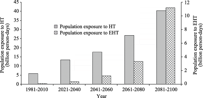
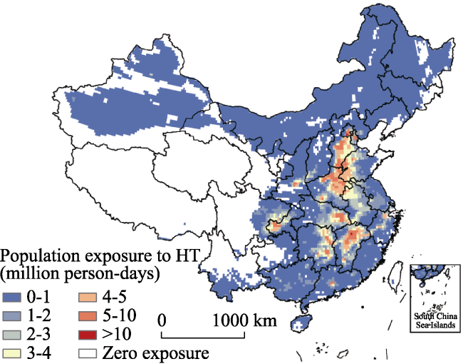
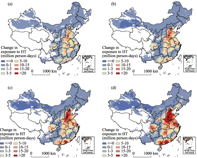
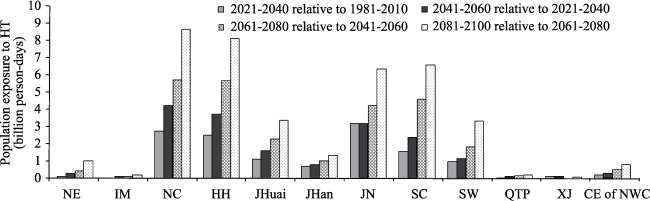
et al.’s study (2014) is that a detailed analysis of population exposure to high temperature was not performed. One aim of this study is therefore to project changes in population exposure to extreme heat under the RCP8.5 scenario across China at the level of individual grid cells based on NASA Earth Exchange Global Daily Downscaled Projections (NEX-GDDP) and the Greenhouse Gas Initiative (GGI) population scenario, in order to evaluate the relative importance of population and climate as drivers of national level population exposure as well as at the level of meteorological geographical divisions. The results of this study provide a clear scientific basis for the identification of hotspots of population exposure to extreme heat, and thus of targets for disaster risk prevention.

2 Materials and methods

2.1 Data sources

Daily maximum temperature data from 21 global climate models were downloaded from the NEX-GDDP dataset within the Climate Data Services provided by NASA. This NEX-GDDP dataset includes downscaled projections for RCP4.5 and RCP8.5 on the basis of 21 models and scenarios (Table 1) for which daily scenarios were produced and distributed via CMIP5. Thus, each of these climate projections includes daily maximum and minimum temperature as well as precipitation for the period between 1950 and 2100. The spatial resolution of this dataset is 0.25 degrees (ca. 25 km by 25 km). The RCP8.5 scenario was selected for analysis in this study and it represents high greenhouse gas emissions. Population scenario data were downloaded from the International Institute for Applied Systems Analysis GGI scenario database. This database encompasses three ‘baseline’ scenarios for different socioeconomic and technological developments, A2r, B1, and B2. The A2r scenario comprises a major numerical revision that reflects the most recent long-term demographic outlook with a corresponding lowering of future world population growth (Riahi et al., 2007). This population scenario was selected in this study because RCP8.5 climate scenario builds upon a socioeconomic and demographic background, resource assumptions and technological base of the A2r scenario (Riahi et al., 2011). The overall dataset has a resolution of 0.5 degrees (ca. 50 km by 50 km) and a temporal resolution of 10 years. This A2r population scenario was interpolated to 0.25 degrees by averaging the original grid to match the spatial resolution of RCP8.5 scenario.
Table 1 The 21 global climatic models included within NEX-GDDP
Model name / Country
ACCESS1-0 / Australia CSIRO-MK3-6-0 / Australia MIROC-ESM / Japan
BCC-CSM1-1 / China GFDL-CM3 / USA MIROC-ESM-CHEM / Japan
BNU-ESM / China GFDL-ESM2G / USA MIROC5 / Japan
CanESM2 / Canada GFDL-ESM2M / USA MPI-ESM-LR / Germany
CCSM4 / USA INMCM4 / Russia MPI-ESM-MR / Germany
CESM1-BGC / USA IPSL-CM5A-LR / France MRI-CGCM3 / Japan
CNRM-CM5 / France IPSL-CM5A-MR / France NorESM1-M / Norway

2.2 Population exposure to extreme heat

High temperature (HT) and extremely high temperature (EHT) are defined in this study based on Chinese climatic and environmental characteristics as cases when daily maximum temperature exceeds 35℃ and 40℃, respectively (Huang et al., 2011). The exposure definition proposed by Jones et al. (2015) states that population exposure to HT (or EHT) can be measured as annual mean high temperature days (or extremely high temperature days) multiplied by the number of people exposed to HT (or EHT). Annual mean high temperature days (or extremely high temperature days) are therefore calculated using the ensemble mean of 21 climate models in the RCP8.5 scenario. Population exposures for a base period between 1981 and 2010, as well as future periods between 2021 and 2040, 2041 and 2060, 2061 and 2080, and 2081 and 2100, are calculated in this study.

2.3 Driving forces of changes in population exposure to extreme heat

The population exposure can be influenced by the number of extreme heat days as well as the number of people. At the same time, changes in this variable can also result from climatic factor (i.e., changes in the number of extreme heat days while population levels remain constant), population factor (i.e., changes in population while the number of extreme heat days remains constant) and the interactive effect between the two (i.e., concurrent changes in population and climate). Change in population exposure is calculated as follows:
\[(x\ +\ \Delta x)\ \cdot \ (y\ +\ \Delta y)\ -\ x\ \cdot \ y\ =\ x\ \cdot \ \Delta y\ +\ y\ \cdot \ \Delta x\ +\ \Delta x\ \cdot \ \Delta y\ (1) \]
where x and y are the number of extreme heat days and the population level, respectively; \(x\ \cdot \ \Delta y\) is the population factor; \(y\ \cdot \ \Delta x\) is the climatic factor; and \(\Delta x\ \cdot \ \Delta y\) is to the interactive factor of the two.
The relative importance of these three factors was calculated using the equations presented below. The climatic factor contribution rate was calculated as:
\[\frac{y\ \cdot \ \Delta x}{(x\ +\ \Delta x)\ \cdot \ (y\ +\ \Delta y)\ -\ x\ \cdot \ y}\ \times \ 100%(2)\ \]
The population factor contribution rate was calculated as:
\[\frac{x\ \cdot \ \Delta y}{(x\ +\ \Delta x)\ \cdot \ (y\ +\ \Delta y)\ -\ x\ \cdot \ y}\ \times \ 100%(3)\ \]
The interactive contribution rate of climate and population was calculated as:
\[\frac{\Delta x\ \cdot \ \Delta y}{(x\ +\ \Delta x)\ \cdot \ (y\ +\ \Delta y)\ -\ x\ \cdot \ y}\ \times \ 100%(4)\ \]

3 Results

3.1 China’s population exposure to extreme heat

The data presented in Figure 1 show that future population exposure to HT and EHT across China is likely to increase significantly from the 2020s onwards. The results also show that within the base period of this study, between 1981 and 2010, population exposure to HT was 5.841 billion person-days. The trends reveal that this HT exposure is likely to increase to 13.433 billion person-days, 17.723 billion person-days, 26.787 billion person-days, and 40.249 billion person-days over the periods between 2021 and 2040, 2041 and 2060, 2061 and 2081, and 2081 and 2100, respectively; these represent 1.3-, 2.0-, 3.6-, and 5.9-time increases, respectively, relative to the base period. Similarly, population exposure to EHT during the base period was 0.133 billion person-days; the results suggest that this exposure is likely to increase to 0.397 billion person-days, 1.243 billion person-days, 3.361 billion person-days, and 11.165 billion person-days over the periods between 2021 and 2040, 2041 and 2060, 2061 and 2081, and 2081 and 2100, respectively; these represent 2.0-, 8.3-, 24.2-, and 82.7-time increases, respectively, compared to the base period. It is clear that population exposure to EHT will increase significantly over the latter part of the 21st century. Particular attention will therefore be required to address the adverse health effects of EHT and, looking to the future, monitoring and warning services should be strengthened.
Figure 1 Plots showing Chinese population exposure to HT and EHT over the base period of this study, between 1981 and 2010, as well as future projected exposures under RCP8.5 climate scenario and A2r population scenario

3.2 The spatial pattern of population exposure to HT

Data show that during the base period of this study, between 1981 and 2010, population exposure to HT in southeastern Beijing, the central and eastern Tianjin, central and southern Hebei, western Shandong, northeastern Henan, northeastern Hubei, central and northern Jiangxi, eastern Hunan, and southwestern Chongqing ranged between four million person-days and ten million person-days, while population exposure to HT across most of China was less than one million person-days (Figure 2).
Figure 2 Map showing population exposure to HT over the base period of this study, between 1981 and 2010
The results show that most parts of China will suffer HT exposure under the RCP8.5 scenario, with the exception of most of Gansu, Qinghai, Tibet, central and western Sichuan, and northern Yunnan. Into the future, relative to the base period between 1981 and 2010, the data show that population exposure to HT across most of China is likely to increase significantly between 2021 and 2041. Regions including southeastern Beijing, the central and eastern Tianjin, central and southern Hebei, western Shandong, northeastern Henan, parts of eastern Hubei and Hunan, and local areas of central Guangdong are likely to experience a large increase in exposure, ranging between ten million person-days and 20 million person-days (Figure 3a). In addition, between 2041 and 2061, exposure across most of China, with the exception of southeastern Xinjiang, is likely to continually increase, relative to the period between 2021 and 2040; indeed, exposure within southeastern Beijing, Tianjin, central and southern Hebei, western Shandong, northeastern Henan, northern Anhui, southern Jiangsu, parts of eastern Hubei and Hunan, and central Guangdong are projected to increase by between ten million person-days and 20 million person-days, while local areas of southeastern Beijing, Tianjin, Henan, Hubei, Shanghai, and Guangdong provinces are projected to see an increase in exposure exceeding 20 million person-days (Figure 3b). Further into the future, between 2061 and 2080, southeastern Beijing, Tianjin, central and southern Hebei, central and western Shandong, central and eastern Henan, northern Anhui, southern Jiangsu, central and southern Guangdong, southeastern Guangxi, and parts of eastern Hubei, central and eastern Hunan, the Sichuan Basin, and the Guanzhong region of Shaanxi are all likely to experience exposure increases of between ten million person-days and 20 million person-days compared to the period between 2041 and 2060. Over the same period, southeastern Beijing, central Tianjin, central and southern Hebei, western Shandong, northeastern Henan, central Guangdong, and local areas within Jiangsu, Shanghai, and Hubei are all likely to experience an increase in exposure exceeding 20 million person-days (Figure 3c). Finally, between 2081 and 2100, most of Beijing, Tianjin, central and southern Hebei, central and western Shandong, northeastern Henan, southern Jiangsu, central and southern Guangdong, and local areas within Shanghai, Zhejiang, Hubei, Hunan, and Guangxi as well as the Sichuan Basin and the Guanzhong region of Shaanxi are likely to experience increases in exposure exceeding 20 million person-days, compared to the period between 2061 and 2080 (Figure 3d).
Figure 3 Maps showing projected changes in Chinese population exposure to HT into the future under RCP8.5 climate scenario and A2r population scenario. Maps showing (a) the exposure increment between 2021 and 2040 relative to the period between 1981 and 2010, (b) between 2041 and 2060 relative to the period between 2021 and 2040, (c) between 2061 and 2080 relative to the period between 2041 and 2060, and (d) between 2081 and 2100 relative to the period between 2061 and 2080
The Handbook of Meteorological Geographical Divisions (NMC, 2006) subdivides China into 11 first-level meteorological geographical regions. These divisions are Northeast China (NE), Inner Mongolia (IM), North China (NC), the Huanghuai (HH), Jianghuai (JHuai), Jianghan (JHan), and Jiangnan (JN) regions, as well as South China (SC) and Southwest China (SW), the Qinghai-Tibet Plateau (QTP), Xinjiang (XJ), and the central-eastern part of Northwest China (CE of NWC). Data show that over the four future time periods considered in this study, the regions NC, HH, SC, JN, JHuai, SW, and JHan are all likely to experience significant increases in population exposure to HT (Figure 4).
Figure 4 Projected changes in regional future population exposure to HT under the RCP8.5 climate scenario and A2r population scenario within the different meteorological geographical divisions of China
Indeed, over the period between 2021 and 2040, population exposure in SC, JHuai, SW, and JHan is likely to increase by more than 0.7 billion person-days relative to the base period, while the JN, NC, and HH regions are likely to experience a larger increase in excess of 2.528 billion person-days. During the period between 2041 and 2060 relative to the period between 2021 and 2040, the SC, JHuai, SW, and JHan regions are likely to experience an increase of over 0.773 billion person-days of exposure, while the NC, HH, and JN regions are all likely to experience a larger increase, in excess of 3.177 billion person-days. Further into the future, the JHuai, SW, and JHan regions are all likely to experience an increase in exposure in excess of 1.029 billion person-days between 2061 and 2080 relative to the period between 2041 and 2060, while the SC, and JN regions will see a larger increase in excess of 4.246 billion person-days, and the largest increase, in excess of 5.682 billion person-days, will be seen in the NC and HH regions. Finally, data show that the JHuai and SW regions will all exhibit an increase in exposure of more than 3.336 billion person-days between 2081 and 2100 relative to the period between 2061 and 2080; within this, the SC, and JN regions are likely to exhibit a larger increase in excess of 6.396 billion person-days, while the largest exposure increase, in excess of 8.145 billion person-days, will be seen within the NC and HH regions.

3.3 Spatial patterns in population exposure to EHT

Data show that over the base period of this study, between 1981 and 2010, the population in parts of Xinjiang, Shaanxi, Shanxi, Inner Mongolia, Beijing, Tianjin, Hebei, Shandong, Henan, Anhui, Hubei, Jiangxi, Hunan and Chongqing all experienced EHT exposure at a level less than 0.1 million person-days. At the same time, population exposure to EHT in southeastern Beijing, central and southern Hebei, northeastern Henan, and in parts of central-northern Jiangxi ranged between 0.1 million person-days and 0.2 million person-days over the base time period (Figure 5).
Figure 5 Map showing population exposure to EHT in China over the base period of this study, between 1981 and 2010
The results of this study show that population exposure to EHT is likely to increase significantly under the RCP8.5 scenario and will affect more regions of China in the future. Predictions suggest that southeastern Beijing, central and eastern Tianjin, central and southern Hebei, northeastern Henan, eastern Hubei, central-northern Jiangxi, and eastern Hunan will all experience an increase in exposure between 2021 and 2040 relative to the base period at levels ranging between 0.6 million person-days and 1.2 million person-days (Figure 6a). Thus, data show that between 2041 and 2060, exposure in southeastern Beijing, most of Tianjin, central and southern Hebei, northwestern Shandong, northeastern Henan, eastern Hubei, central-northern Jiangxi, and northeastern Hunan is likely to increase by more than 1.2 million person-days when compared to the period between 2021 and 2040 (Figure 6b). Predictions also suggest that between 2061 and 2080, people living across most of central and eastern China will also experience EHT exposure, while those in eastern Beijing, Tianjin, central and southern Hebei, central and western Shandong, central and eastern Henan, central and northern Anhui, western and southern Jiangsu, northern Zhejiang, northern Jiangxi, eastern Hunan and Hubei, southwestern Chongqing, the southeastern part of the Sichuan Basin, the Guanzhong region of Shaanxi, and in southwestern Shanxi will all be subjected to an increase in excess of 1.2 million person-days between 2061 and 2080 relative to the period 2041-2060 (Figure 6c). Similarly, between 2081 and 2100, most of central and eastern China, western Chongqing, and the Sichuan Basin are likely to experience an increase in excess of 1.2 million person-days of exposure relative to the period between 2061 and 2080 (Figure 6d).
Figure 6 Maps showing projected changes in Chinese population exposure to EHT into the future under the RCP8.5 climate scenario and A2r population scenario. Maps show (a) the exposure increment between 2021 and 2040 relative to the period between 1981 and 2010, (b) between 2041 and 2060 relative to the period between 2021 and 2040, (c) between 2061 and 2080 relative to the period between 2041 and 2060, and (d) between 2081 and 2100 relative to the period between 2061 and 2080
Data show that the NC, HH, JN, JHuai, SW, and JHan regions will all experience significant increases in exposure to EHT (Figure 7). Indeed, relative to the base period, population exposure in JN, NC, JHuai, and HH is likely to increase by more than 0.039 billion person-days between 2021 and 2040. Over the period between 2041 and 2060, the NC, JN, HH, JHuai, JHan, and SW regions are likely to exhibit an increase in exposure in excess of 0.062 billion person-days relative to the period between 2021 and 2040. Specifically, the NC and JN regions are likely to experience a larger increase in excess of 0.316 billion person-days over this period. Further into the future, NC, HH, JN, JHuai, SW, JHan, CE of NWC, SC, and XJ will all experience an increase in exposure in excess of 0.034 billion person-days between 2061 and 2080 relative to the period between 2041 and 2060; over the period, the NC, HH, and JN regions are all likely to experience increases in exposure in excess of 0.688 billion person-days, while JHuai will experience an increase of more than 0.329 billion person-days. Data show that most regions of China, with the exception of NE, IM, QTP, and XJ, will experience an increase in exposure in excess of 0.182 billion person-days between 2081 and 2100 relative to the period between 2061 and 2080; increases in exposure within the NC and HH regions are likely to be in excess of 2.694 billion person-days while those within the JN, JHuai, SW, JHan, and SC regions will be in excess of 0.437 billion person-days.
Figure 7 Projected changes in regional future population exposure to EHT under the RCP8.5 climate and A2r population scenarios within the different meteorological geographical divisions of China

3.4 Driving forces of changes in future population exposure to HT and EHT

The data presented in Table 2 show that the climatic factor is the most important driver of exposure at the national level, followed by the interactive effect between population and climate. Predictions suggest that the climate contribution rate to national-level projected changes in exposure will decrease gradually, from ca. 70% to ca. 60%, while the contribution rate of concurrent changes in population and climate is likely to increase gradually over the four future time periods considered in this study, ranging between ca. 20% to ca. 40%. In contrast, the influence of population on projected changes in exposure is predicted to be relatively small; the maximum contribution rates of population to changes in HT and EHT exposure are 13.1% and 7.7%, respectively, between 2021 and 2041 relative to the period between 1981 and 2010 (Table 2).
Table 2 Analysis of the driving forces of changes in population exposure to HT and EHT across China (%)
Change of population
exposure
HT (≥35℃) EHT (≥40℃)
Population factor Climatic factor Interactive effect between climate and
population
Population
factor
Climatic
factor
Interactive effect between climate and population
Between 2021 and 2040 relative to 1981-2010 13.1 67.6 19.4 7.7 68.9 23.4
Between 2041 and 2060 relative to 2021-2040 2.9 67.6 29.5 0.9 67.1 32.1
Between 2061 and 2080 relative to 2041-2060 1.5 66.3 32.2 0.3 65.4 34.4
Between 2081 and 2100 relative to 2061-2080 1.8 58.4 39.9 0.1 59.9 40.0
The NC, HH, JHuai, JHan, JN, SC, and SW regions are predicted to be future hotspots that will experience significant changes in population exposure to HT and EHT. The contribution rates of climate, population, and the interaction between the two are listed in Table 3; the data show that changes in population exposure over the four future time periods will be driven mainly by climatic factor in the case of most hotspots (with the exception of NC), followed by the interaction between climate and population. Similarly, the population factor on exposure is likely to be relatively small across all hotspots, at a less than 9% contribution rate in most cases. The results show that the climatic factor will be absolutely dominant in terms of driving changes in population exposure to HT in the SW regions, at a contribution rate in excess of 90%; this effect will also dominate changes in population exposure to EHT within the SW and SC regions (Table 3).
Table 3 Analysis of the driving forces of changes in population exposure to HT and EHT across the different meteorological geographical divisions of China (%)
Change in population exposure Division HT (≥35℃) EHT (≥40℃)
Population factor Climatic factor Interactive effect between climate and population Population factor Climatic factor Interactive
effect between climate and population
Between 2021 and 2040 relative to between 1981 and 2010 NC 30.1 40.0 29.9 19.0 45.6 35.5
HH 13.5 63.4 23.1 8.6 66.9 24.5
JHuai 11.1 68.3 20.6 3.4 75.7 20.9
JHan 9.0 72.1 18.9 2.4 77.8 19.8
JN 9.7 74.6 15.7 1.9 78.6 19.5
SC 3.9 78.9 17.2 -12.7 152.6 -39.9
SW 2.5 92.9 4.6 0.3 96.4 0.3
Between 2041 and 2060 relative to between 2021 and 2040 NC 8.7 39.7 51.7 2.6 43.5 53.9
HH 2.8 62.3 34.9 0.5 65.8 33.7
JHuai 2.0 67.9 30.1 0.3 71.7 28.0
JHan 1.7 73.0 25.3 0.1 74.0 25.9
JN 1.3 77.7 21.1 0.1 76.0 23.9
SC 0.3 76.2 23.5 -0.4 125.1 -24.7
SW -2.5 106.5 -4.0 -0.4 107.6 -7.1
Between 2061 and 2080 relative to between 2041 and 2060 NC 4.7 36.6 58.7 0.7 40.0 59.2
HH 14.6 58.8 39.8 0.1 63.2 36.6
JHuai 1.1 64.3 34.6 0.1 67.6 32.3
JHan 1.1 71.3 27.6 0.0 71.2 28.8
JN 1.0 77.2 21.8 0.1 75.4 24.6
SC 0.2 71.7 28.1 0.0 92.8 7.2
SW -0.9 108.0 -7.0 -0.1 106.7 -6.6
Between 2081 and 2100 relative to between 2061 and 2080 NC 3.6 31.8 64.6 0.3 35.3 64.4
HH 1.7 48.7 49.6 0.1 56.2 43.7
JHuai 1.5 54.3 44.2 0.1 61.3 38.6
JHan 2.0 61.2 36.9 0.0 65.5 34.5
JN 2.1 66.4 31.5 0.1 69.0 30.9
SC 0.4 62.1 37.6 0.0 80.9 19.1
SW 0.4 99.9 -0.3 0.0 100.6 -0.6

4 Discussion and conclusions

Changes in population exposure to HT and EHT were projected across China in this study based on the most up-to-date global high-resolution climate models and the population projection data encapsulated in the A2r socio-economic scenario. This approach enabled a discussion of the factors influencing changes in population exposure over time.
The predictions presented in this study show that over the time periods between 2021 and 2040, 2041 and 2060, 2061 and 2080, and 2081 and 2100, national projected exposure to HT will increase by 1.3, 2.0, 3.6, and 5.9 times, respectively, relative to the base period of this study, while projected exposure to EHT is likely to increase by 2.0, 8.3, 24.2, and 82.7 times, respectively. Future predictions suggest that HT conditions are likely to occur across most parts of China, with the exception of most of Gansu, Qinghai, Tibet, central and western Sichuan, and northern Yunnan, and the population exposure to HT will increase significantly from the period between 2021 and 2040 onwards. Over the period between 2081 and 2100, population exposure to HT is likely to increase significantly within Beijing, Tianjin, central and southern Hebei, central and western Shandong, northeastern Henan, southern Jiangsu, central and northern Anhui, eastern Hubei and Hunan, central and southern Guangdong, southeastern Guangxi, and the Sichuan Basin. Population exposure to EHT is likely to increase significantly in most parts of central and eastern China, western Chongqing, and the Sichuan Basin. In terms of meteorological geographical divisions, population exposure to HT is predicted to significantly increase in the NC, HH, SC, JN, JHuai, SW, and JHan regions over the four future time periods considered in this study, with those within the first four likely to be the most significant. Similarly, population exposure to EHT will increase significantly within the NC, HH, JN, JHuai, SW, and JHan regions over the four future time periods, with increases in the first four again likely to be the most significant.
Population exposure to HT and EHT over the four future time periods considered in this study is likely to be mainly driven by climatic factor at the national level, followed by the interactive effect between climate and population. Data show that the climatic factor gradually decreases over the four future time periods, with the rate of contribution decreasing from 67.6% to 58.4% in the case of population exposure to HT and from 68.9% to 59.9% in the case of EHT. Similarly, the interactive effect between climate and population gradually increases with the contribution rate increasing from ca. 20.0% to ca. 40.0%.
At the level of meteorological geographical divisions, changes in population exposure to HT and EHT in the NC region over the three periods (i.e., between 2041 and 2060 relative to 2021 and 2040, between 2061 and 2080 relative to 2041 and 2060, and between 2081 and 2100 relative to 2061 and 2080) are mainly driven by interactive effect between population and climate, followed by just the latter. In the HH, JHuai, JHan, JN, SC, and SW regions, data show that changes in population exposure are mainly driven by climatic factor, followed by interactive effects. Population factor on exposure is relatively small within each division going forward into future time periods; data show that the climatic factor absolutely dominates changes in population exposure to HT and EHT in the SW region, while the climatic factor absolutely dominates changes in population exposure to EHT in the SC region.
The results of this study show that there is likely to be an overall significant increase in population exposure to HT across much of central and eastern China in all future scenarios as well as a much more significant increase in EHT population exposure. Additional attention should therefore be paid to monitoring and warning services in relation to future extreme heat within China.
The ensemble mean method that is commonly applied to project future climate change was used in this study to develop a series of extreme heat scenarios. The uncertainty inherent in multi-models requires further evaluation in the future. An analysis of population exposure to extreme heat at the grid scale is presented in this study in order to explore changes in population exposure as well as the impacts of population and climatic factor. A number of hotspots in population exposure changes are identified in this study, while the detailed findings provide guidance for extreme heat monitoring, warning, and risk prevention. Population exposure to extremely heat is an important component of heat stress risk assessment; the exploration of population exposure presented in this study therefore advances research on the risks associated with heat stress.

The authors have declared that no competing interests exist.

[1]
Barriopedro D, Fischer E M, Luterbacher Jet al., 2011. The hot summer of 2010: Redrawing the temperature record map of Europe.Science, 332(6026): 220-224.The recently emerging three-dimensional (3D) displays in the electronic shops imitate depth illusion by overlapping two parallax 2D images through either polarized glasses that viewers are required to wear or lenticular lenses fixed directly on the display. Holography, on the other hand, provides real 3D imaging, although usually limiting colors to monochrome. The so-called rainbow holograms-mounted, for example, on credit cards-are also produced from parallax images that change color with viewing angle. We report on a holographic technique based on surface plasmons that can reconstruct true 3D color images, where the colors are reconstructed by satisfying resonance conditions of surface plasmon polaritons for individual wavelengths. Such real 3D color images can be viewed from any angle, just like the original object.

DOI

[2]
Benmarhnia T, Kihal-Talantikite W, Ragettli M Set al., 2017. Small-area spatiotemporal analysis of heatwave impacts on elderly mortality in Paris: A cluster analysis approach.Science of the Total Environment, 592: 288-294.BACKGROUND: Heat-waves have a substantial public health burden. Understanding spatial heterogeneity at a fine spatial scale in relation to heat and related mortality is central to target interventions towards vulnerable communities. OBJECTIVES: To determine the spatial variability of heat-wave-related mortality risk among elderly in Paris, France at the census block level. We also aimed to assess area-level social and environmental determinants of high mortality risk within Paris. METHODS: We used daily mortality data from 2004 to 2009 among people aged >65 at the French census block level within Paris. We used two heat wave days' definitions that were compared to non-heat wave days. A Bernoulli cluster analysis method was applied to identify high risk clusters of mortality during heat waves. We performed random effects meta-regression analyses to investigate factors associated with the magnitude of the mortality risk. RESULTS: The spatial approach revealed a spatial aggregation of death cases during heat wave days. We found that small scale chronic PM10 exposure was associated with a 0.02 (95% CI: 0.001; 0.045) increase of the risk of dying during a heat wave episode. We also found a positive association with the percentage of foreigners and the percentage of labor force, while the proportion of elderly people living in the neighborhood was negatively associated. We also found that green space density had a protective effect and inversely that the density of constructed feature increased the risk of dying during a heat wave episode. CONCLUSION: We showed that a spatial variation in terms of heat-related vulnerability exists within Paris and that it can be explained by some contextual factors. This study can be useful for designing interventions targeting more vulnerable areas and reduce the burden of heat waves.Copyright 2017 Elsevier B.V. All rights reserved.

DOI PMID

[3]
Blumberg G, 2014. Assessing the potential impact of heat waves in cities: Implications for hazard preparation and planning.Procedia Economics and Finance, 18: 727-735.This paper summarizes the hazards of high temperature extremes in the built environment and considers the challenges of managing risk with uncertainty of prediction of the magnitude and frequency of events. The application of extreme value statistics on a typical time series of temperature data has provided some insight into the observed and predicted variability. Using a long temperature time series as an example it is shown that return periods and the increased risk associated with climate change can be interpolated from the analysis. Considering the chaotic nature of cities, their rapid growth and a warming climate, it is suggested that cities could be made more resilient to heat waves if governments were be better able to appropriately allocate resources to manage the hazard.

DOI

[4]
Cheema A R, 2015. Pakistan: High-rise buildings worsened heatwave.Nature, 524(7563): 35.A letter to the editor is presented concerning the role of high-rise buildings in the severity of the summer 2015 heat wave in Karachi, Pakistan, and the need for better urban policies.

DOI PMID

[5]
Chen K, Bi J, Chen Jet al., 2015. Influence of heat wave definitions to the added effect of heat waves on daily mortality in Nanjing, China.Science of the Total Environment, 506/507: 18-25.61Significant added effects of heat waves on cause-specific mortality were found.61Heat wave definitions had considerable impacts on these added effects.61Modifying effect of age, gender and education was found under different definitions.

DOI PMID

[6]
Deng Zhenyong, Zhang Qiang, Xu Jinfanget al., 2009. Comparative studies of the harm characteristic of hot-dry wind and high temperature heatwaves.Advances in Earth Science, 24(8): 865-873. (in Chinese)lt;p>This paper summarized six aspects such as the harm characteristics, type and index, climatic characteristics, causes, responding to globe changes, protecting technology and answering tactics of hot-dry wind and high temperature heat wave. There is distinction and relationship between hotdry wind and high temperature heat wave. This includes that both of hot-dry wind and high temperature heat wave belong to serious shorter time scale weather disasters. Lower humidity and higher temperature are their main characteristics. The two causes of abnormal circulation characteristics and impacts of the disasters from climate change are basically the same. The disasters may occur in the same area during the same period. Arid season is helphul for their development and aggravation damage. There are differences on harm characteristics, type and index, climatic characteristics, protecting technology and answering tactics in this two weather disasters in that the high temperature heat wave is the comprehensiveness meteorological disasters and dry-hot wind is the agrometeorological disasters.</p>

[7]
Ding T, Qian W H, Yan Z W, 2010. Changes in hot days and heatwaves in China during 1961-2007.International Journal of Climatology, 30(10): 1452-1462.

[8]
Dong Siyan, Xu Ying, Zhou Botaoet al., 2014. Projected risk of extreme heat in China based on CMIP5 models.Advances in Climate Change Research, 10(5): 365-369. (in Chinese)Based on the simulations from 22 CMIP5 models and in combination with the socio-economic data, the extreme heat risk change during the near term (2016-2035), medium term (2046-2065) and long term (2080-2099) were projected by quantitative estimation under RCP8.5. The results show that the extreme heat hazard risk will gradually increase during different terms in the future, and extreme heat risk will also tend to increase. Class III and above of the extreme heat risk will increase, especially in the northeast, Inner Mongolia, Shaanxi, Ningxia, Guizhou, Fujian provinces (autonomous region). In Shandong, Hebei, Henan, Anhui provinces, Class V of the extreme heat risk tends to appear in the near term, and it will extend to Jiangsu, Hunan, Hubei, Jiangxi, Sichuan, Guangxi and Guangdong provinces (autonomous region) in the medium and long term.

DOI

[9]
Gasparrini A, Armstrong B, 2011. The impact of heat waves on mortality.Epidemiology, 22(1): 68-73.Heat waves have been linked with an increase in mortality, but the associated risk has been only partly characterized. We examined this association by decomposing the risk for temperature into a "main effect" due to independent effects of daily high temperatures, and an "added" effect due to sustained duration of heat during waves, using data from 108 communities in the United States during 1987-2000. We adopted different definitions of heat-wave days on the basis of combinations of temperature thresholds and days of duration. The main effect was estimated through distributed lag nonlinear functions of temperature, which account for nonlinear delayed effects and short-time harvesting. We defined the main effect as the relative risk between the median city-specific temperature during heat-wave days and the 75th percentile of the year-round distribution. The added effect was defined first using a simple indicator, and then a function of consecutive heat-wave days. City-specific main and added effects were pooled through univariate and multivariate meta-analytic techniques. The added wave effect was small (0.2%-2.8% excess relative risk, depending on wave definition) compared with the main effect (4.9%-8.0%), and was apparent only after 4 consecutive heat-wave days. Most of the excess risk with heat waves in the United States can be simply summarized as the independent effects of individual days' temperatures. A smaller added effect arises in heat waves lasting more than 4 days.

DOI PMID

[10]
Grumm R H, 2011. The central European and Russian heat event of July-August 2010.Bulletin of the American Meteorological Society, 92(10): 1285-1296.

[11]
Gu S, Huang C, Bai Let al.Bai L , 2016. Heat-related illness in China, summer of 2013.International Journal of Biometeorology, 60: 131-137.Extreme heat events have occurred more frequently in China in recent years, leading to serious impacts on human life and the health care system. To identify the characteristics of individuals with heat-related illnesses in China during the summer of 2013, we collected the data from the Heat-related Illness Surveillance System in Chinese Center for Disease Control and Prevention (China CDC). A total of 5758 cases were reported in the summer of 2013, mostly concentrated in urban areas around the middle and lower reaches of the Yangtze River. We found a difference in age distribution of percentage of deaths from heat-related illness between males and females. Severe cases in males mostly occurred in the age group 45-74 years but in females mostly in the age group over 75. A distributed lag non-linear model had been used to identify population vulnerabilities in Ningbo and Chongqing. The results show that there was a clear positive relationship between maximum temperature and heat-related illness, and the heat effect was nonlinear and could last for 3 days. The elderly and males in the range of 45-64 years old might be the most vulnerable people of heat-related illness in China. We also highlighted some deficiencies of the surveillance system, such that the reported data were not accurate, comprehensive, or timely enough at this stage.

DOI PMID

[12]
He Shanfeng, Dai Erfu, Ge Quanshenget al., 2010. Pre-estimation of spatiotemporal pattern of extreme heat hazard in China.Journal of Natural Disasters, 19(2): 91-97. (in Chinese)

[13]
Huang Zhuo, Chen Hui, TianHua, 2011. Research on the heat wave index.Meteorological Monthly, 37(3): 345-351. (in Chinese)Heat waves appear usually accompanied by both the abnormal high temperature(or high temperature and muggy weather) and a persistent period of high temperature weather.According to these two characteristics,heat-wave index is designed as an identification index of heat wave weather to show the torridity extent and accumulative effect of high-temperature process,and the classification standard of heat waves is established.Heat-wave index and meteorological grades were tested by daily numbers of heatstroke sufferers in Wuhan during July to August of 1994 and 1995 and daily numbers of death in Shanghai during July to August of 2003.The results show that the heat-wave index is a valid index to predict heat wave weather.The method on grading of heat wave can be applied to the actual operation.

[14]
IPCC, 2014a.Climate Change 2014: Synthesis Report. In: Contribution of Working Groups I, II and III to the Fifth Assessment Report of the Intergovernmental Panel on Climate Change.IPCC, Geneva, Switzerland.

[15]
IPCC, 2014b. Climate Change 2014:Impacts, Adaptation, and Vulnerability. Part A: Global and Sectoral Aspects. Contribution of Working Group II to the Fifth Assessment Report of the Intergovernmental Panel on Climate Change.Cambridge, United Kingdom and New York, NY, USA: Cambridge University Press.

[16]
Johnson W B,2017. Phoenix breaks 112-year-old heat record.The Republic, azcentral.com. URL: .

[17]
Jones B, O’Neill B C, McDaniel Let al., 2015. Future population exposure to US heat extremes.Nature Climate Change, 5(7): 652-655.Extreme heat events are likely to become more frequent in the coming decades owing to climate change. Exposure to extreme heat depends not only on changing climate, but also on changes in the size and spatial distribution of the human population. Here we provide a new projection of population exposure to extreme heat for the continental United States that takes into account both of these factors. Using projections from a suite of regional climate models driven by global climate models and forced with the SRES A2 scenario and a spatially explicit population projection consistent with the socioeconomic assumptions of that scenario, we project changes in exposure into the latter half of the twenty-first century. We find that US population exposure to extreme heat increases four- to sixfold over observed levels in the late twentieth century, and that changes in population are as important as changes in climate in driving this outcome. Aggregate population growth, as well as redistribution of the population across larger US regions, strongly affects outcomes whereas smaller-scale spatial patterns of population change have smaller effects. The relative importance of population and climate as drivers of exposure varies across regions of the country.

DOI

[18]
Li Shuangshuang, Yang Saini, Zhang Donghaiet al., 2015. Spatiotemporal variability of heat waves in Beijing-Tianjin-Hebei Region and influencing factors in recent 54 years.Journal of Applied Meteorological Science, 26(5): 545-554. (in Chinese)It indicates that hot summers will become more frequent in eastern China in the future.The region will face a great risk in the absence of any adaptation measures taken towards reducing its vulnerability to effects of extreme heat.Beijing-Tianjin-Hebei Region is identified as the biggest metropolitan in northern China.Rapid urbanization and the recent frequent occurrence of hot summers in the region raises questions about influencing factors at the regional scale and the spatiotemporal variability of heat waves.Using the newly developed Heatwave Index(HI),a statistical analysis is conducted on the temporal and spatial distribution characteristics of heat waves in Beijing-Tianjin-Hebei Region over a period from 1960 to 2013.More specifically,based on the history of relocations,the heat wave trends between Beijing and Fengning is compared to investigate the influence of urbanization,and also analyse the relationship between atmospheric circulation anomalies and observed heat wave trends.It shows that based on variations in heat wave trends,two distinct phases are identified in Beijing-Tianjin-Hebei Region.Owing to some abrupt changes in the mid-1970 s,the frequency of heat waves decrease from 1960 to 1973,and then increase from 1974 to2013.Heat waves show a decreasing trend in the southern part and an increasing trend in the northern part of Beijing-Tianjin-Hebei Region.A significant increasing trend is found in the northern and western biological conservation area,and decreasing trend in south-eastern plains.At the regional scale,urbanization and relocations affect the occurrence of slight to moderate rather than extreme heat waves.In the period of global warming and rapid urbanization,the frequency of heat waves in Beijing is higher than that of Fengning.In recent global warming hiatus,the frequency of heat waves in Beijing is lower than Fengning.Driving factors behind temporal and spatial patterns are deemed complicated.The inter-decadal variations are significantly and closely related to the offsetting of western Pacific subtropical high(WPSH) ridge and the anomalous anticyclone over the Tibetan Plateau(TPAI) in summer.In other words,there is a positive correlation between the number of heat wave days and WPSH and TPAI.Furthermore,the probability of a summer with a mega-heat wave would increase with the anomalies in WPSH and TPAI.

[19]
Liu Jianjun, Zheng Youfei, Wu Rongjun, 2008. Impacts of heat waves disaster on human health and its research method.Journal of Natural Disasters, 17(1): 151-156. (in Chinese)

DOI

[20]
Luterbacher J, Dietrich D, Xoplaki Eet al., 2004. European seasonal and annual temperature variability, trends, and extremes since 1500. Science, 2004, 303(5663): 1499-1503.

[21]
Mora C, Dousset B, Caldwell I Ret al.Caldwell I R , 2017. Global risk of deadly heat.Nature Climate Change, 7(7): 501-506.Climate change can increase the risk of conditions that exceed human thermoregulatory capacity. Although numerous studies report increased mortality associated with extreme heat events, quantifying the global risk of heat-related mortality remains challenging due to a lack of comparable data on heat-related deaths. Here we conducted a global analysis of documented lethal heat events to identify the climatic conditions associated with human death and then quantified the current and projected occurrence of such deadly climatic conditions worldwide. We reviewed papers published between 1980 and...

DOI

[22]
National Meteorological Center (NMC), 2006. Handbook of Meteorological Geographical Divisions in China. Beijing: China Meteorological Press. (in Chinese)

[23]
Peng Haiyan, Zhou Zengkui, Zhao Yonglinget al., 2005. The analysis of abnormal high temperature in 2003 summer.Scientia Meteorologica Sinica, 25(4): 355-361. (in Chinese)For the part of China and world in 2003,the lasting hot weather appears in the high summer.Based on the circulation characteristics and data of the temperature of Nanjing for the recent 100 years,the reason of a hot weather anomaly in the middle and lower reaches of Changjiang River is studied on the synoptic and climatic characteristics.The results show that the variations of the west Pacific subtropical high ridge are in accord with the normal circulation of the high temperature in summer,but the intensity of the west Pacific Subtropical high is stronger than normal.Even so the hot weather days in Nanjing in 2003 summer still did not break through history records.The duration of the lasting hot weather in the late July and early August and the cold weather in the middle of August are corresponding to the variation of the atmosphere circulation and climatic characteristics.

[24]
Perkins-Kirkpatrick S E, Gibson P B, 2017. Changes in regional heatwave characteristics as a function of increasing global temperature.Scientific Reports, 7: 12256. doi: 10.1038/s41598-017-12520-2.Abstract The Paris Agreement calls for global warming to be limited to 1.5-209000900°C. For the first time, this study investigates how different regional heatwave characteristics (intensity, frequency and duration) are projected to change relative to increasing global warming thresholds. Increases in heatwave days between 4-34 extra days per season are projected per 00°C of global warming. Some tropical regions could experience up to 120 extra heatwave days/season if 509000900°C is reached. Increases in heatwave intensity are generally 0.5-1.509000900°C above a given global warming threshold, however are higher over the Mediterranean and Central Asian regions. Between warming thresholds of 1.509000900°C and 2.509000900°C, the return intervals of intense heatwaves reduce by 2-3 fold. Heatwave duration is projected to increase by 2-10 days/00°C, with larger changes over lower latitudes. Analysis of two climate model ensembles indicate that variation in the rate of heatwave changes is dependent on physical differences between different climate models, however internal climate variability bears considerable influence on the expected range of regional heatwave changes per warming threshold. The results of this study reiterate the potential for disastrous consequences associated with regional heatwaves if global mean warming is not limited to 2 degrees.

DOI PMID

[25]
Riahi K, Grübler A, Nakicenovic N, 2007. Scenarios of long-term socio-economic and environmental development under climate stabilization.Technological Forecasting and Social Change, 74(7): 887-935This paper presents an overview of the greenhouse gas (GHG) emissions scenarios that form the analytical backbone for other contributions to this Special Issue. We first describe the motivation behind this scenario exercise and introduce the main scenario features and characteristics, in both qualitative and quantitative terms. Altogether, we analyze three aseline scenarios of different socio-economic and technological developments that are assumed not to include any explicit climate policies. We then impose a range of climate stabilization targets on these baseline scenarios and analyze in detail the feasibility, costs and uncertainties of meeting a range of different climate stabilization targets in accordance with Article 2 of the United Nations Framework Convention on Climate Change. The scenarios were developed by the IIASA Integrated Assessment Modeling Framework that encompasses detailed representations of the principal GHG-emitting sectors nergy, industry, agriculture, and forestry. The main analytical findings from our analysis focus on the implications of salient uncertainties (associated with scenario baselines and stabilization targets), on feasibility and costs of climate stabilization efforts, and on the choice of appropriate portfolios of emissions abatement measures. We further analyze individual technological options with regards to their aggregated cumulative contribution toward emissions mitigation during the 21st century as well as their deployment over time. Our results illustrate that the energy sector will remain by far the largest source of GHG emissions and hence remain the prime target of emissions reduction. Ultimately, this may lead to a complete restructuring of the global energy system. Climate mitigation could also significantly change the relative economics of traditional versus new, more climate friendly products and services. This is especially the case within the energy system, which accounts for the largest share of emissions reductions, but it is also the case in the agriculture and forestry sectors, where emissions reduction and sink enhancement measures are relatively more modest.

DOI

[26]
Riahi K, Rao S, Krey Vet al.2011. RCP 8.5: A scenario of comparatively high greenhouse gas emissions.Climatic Change, 109(1): 33-57.This paper summarizes the main characteristics of the RCP8.5 scenario. The RCP8.5 combines assumptions about high population and relatively slow income growth with modest rates of technological change and energy intensity improvements, leading in the long term to high energy demand and GHG emissions in absence of climate change policies. Compared to the total set of Representative Concentration Pathways (RCPs), RCP8.5 thus corresponds to the pathway with the highest greenhouse gas emissions. Using the IIASA Integrated Assessment Framework and the MESSAGE model for the development of the RCP8.5, we focus in this paper on two important extensions compared to earlier scenarios: 1) the development of spatially explicit air pollution projections, and 2) enhancements in the land-use and land-cover change projections. In addition, we explore scenario variants that use RCP8.5 as a baseline, and assume different degrees of greenhouse gas mitigation policies to reduce radiative forcing. Based on our modeling framework, we find it technically possible to limit forcing from RCP8.5 to lower levels comparable to the other RCPs (2.6 to 6W/m 2 ). Our scenario analysis further indicates that climate policy-induced changes of global energy supply and demand may lead to significant co-benefits for other policy priorities, such as local air pollution.

DOI

[27]
Schoof J T, Ford T W, Pryor S Cet al., 2017. Recent changes in U.S. regional heat wave characteristics in observations and reanalyses.Journal of Applied Meteorology and Climatology, 56: 2621-2636.

[28]
Shi Jun, Ding Yihui, Cui Linli, 2008. Climatic characteristics and their changing law during summer high-temperature times in East China.Acta Geographica Sinica, 63(3): 237-246. (in Chinese)Based on the daily highest temperature data covering the period 1961-2005, temporal and spatial characteristics and their changing in mean annual and monthly high temperature days (HTDs) and the mean daily highest temperature (MDHT) during annual and monthly HTDs in East China were studied. The results show that the mean annual HTDs were 15.1 and the MDHT during annual HTDs was 36.3 oC in the past 45 years. Both the mean annual HTDs and the MDHT during annual HTDs were negative anomaly in the 1980s and positive anomaly in the other periods of time, oscillating with a cycle of about 12-15 years. The mean annual HTDs were more in the southern part, but less in the northern part of East China. The MDHT during annual HTDs was higher in Zhejiang, Anhui and Jiangxi provinces in the central and western parts of East China. The high temperature process (HTP) was more in the southwestern part, but less in the northeastern part of East China. Both the numbers of HTDs and HTP were most in July, and the MDHT during monthly HTDs was also the highest in July. In the first 5 years of the 21st century, the mean annual HTDs and the MDHT during annual HTDs increased at most of the stations, both the mean monthly HTDs and the MDHT during monthly HTDs were positive anomaly from April to October, the number of each type of HTP generally was the most and the MDHT in each type of HTP was also the highest.

DOI

[29]
Sun Jianqi, Wang Huijun, Yuan Wei, 2011. Decadal variability of the extreme hot event in China and its association with atmospheric circulation.Climatic and Environmental Research, 16(2): 199-208. (in Chinese)Using observational daily maximum temperature of Chinese 181 stations for the period of 1957-2004,the spatio-temporal features of the climatology and decadal variability of the extreme hot event(EHE) frequency,intensity,onset date(EHE-OD),and termination date(EHE-TD) are investigated.The climatological analysis indicates that southeastern China and Xinjiang are the two major domains for the EHE,and eastern China is a region with a strong interannual variability.The EHE experienced strong decadal variability in the last 48 years.The variabilities of the frequency and intensity are consistent,and the variabilities of the EHE-OD and EHE-TD are similar.Based on the EHE spatio-temporal feature,the whole China can be divided into four sub-regions:Southern China,central China,eastern northern China,and Northwest China.The EHE frequency is high in the 1960s and the 1980s for southern China,in the 1960s and the 1990s for central China,and in the 1990s for northern China.Further,the atmospheric circulations which are responsible for the interannual and decadal variability of the EHE in the above four sub-regions are explored.It suggests that the circulations impacting on the interannual and decadal variability are consistent.For northern China,the major circulation is the overlying geopotential height anomaly at middle-to-upper levels.For southern and central China,the major circulations are the overlying geopotential height anomaly at middle-to-upper levels and temperature advection by the meridional wind at lower levels.

DOI

[30]
Tan Jianguo, Lu Chen, Chen Zhenghong, 2009. Heat Waves and Human Health. Beijing: China Meteorological Press. (in Chinese)

[31]
Trenberth K E, Fasullo J T., 2012. Climate extremes and climate change: The Russian heat wave and other climate extremes of 2010.Journal of Geophysical Research: Atmospheres, 117(D17): 2399-2417.1] A global perspective is developed on a number of high impact climate extremes in 2010 through diagnostic studies of the anomalies, diabatic heating, and global energy and water cycles that demonstrate relationships among variables and across events. Natural variability, especially ENSO, and global warming from human influences together resulted in very high sea surface temperatures (SSTs) in several places that played a vital role in subsequent developments. Record high SSTs in the Northern Indian Ocean in May 2010, the Gulf of Mexico in August 2010, the Caribbean in September 2010, and north of Australia in December 2010 provided a source of unusually abundant atmospheric moisture for nearby monsoon rains and flooding in Pakistan, Colombia, and Queensland. The resulting anomalous diabatic heating in the northern Indian and tropical Atlantic Oceans altered the atmospheric circulation by forcing quasi-stationary Rossby waves and altering monsoons. The anomalous monsoonal circulations had direct links to higher latitudes: from Southeast Asia to southern Russia, and from Colombia to Brazil. Strong convection in the tropical Atlantic in northern summer 2010 was associated with a Rossby wave train that extended into Europe creating anomalous cyclonic conditions over the Mediterranean area while normal anticyclonic conditions shifted downstream where they likely interacted with an anomalously strong monsoon circulation, helping to support the persistent atmospheric anticyclonic regime over Russia. This set the stage for the 090008blocking090009 anticyclone and associated Russian heat wave and wild fires. Attribution is limited by shortcomings in models in replicating monsoons, teleconnections and blocking.

DOI

[32]
van Oldenborgh G J, Philip S, Kew Set al., 2018. Extreme heat in India and anthropogenic climate change.Natural Hazards and Earth System Sciences, 18(1): 365-381.On 19 May 2016 the afternoon temperature reached 51.0 C in Phalodi in the northwest of India - a new record for the highest observed maximum temperature in India. The previous year, a widely reported very lethal heat wave occurred in the southeast, in Andhra Pradesh and Telangana, killing thousands of people. In both cases it was widely assumed that the probability and severity of heat waves in India are increasing due to global warming, as they do in other parts of the world. However, we do not find positive trends in the highest maximum temperature of the year in most of India since the 1970s (except spurious trends due to missing data). Decadal variability cannot explain this, but both increased air pollution with aerosols blocking sunlight and increased irrigation leading to evaporative cooling have counteracted the effect of greenhouse gases up to now. Current climate models do not represent these processes well and hence cannot be used to attribute heat waves in this area. The health effects of heat are often described better by a combination of temperature and humidity, such as a heat index or wet bulb temperature. Due to the increase in humidity from irrigation and higher sea surface temperatures (SSTs), these indices have increased over the last decades even when extreme temperatures have not. The extreme air pollution also exacerbates the health impacts of heat. From these factors it follows that, from a health impact point of view, the severity of heat waves has increased in India. For the next decades we expect the trend due to global warming to continue but the surface cooling effect of aerosols to diminish as air quality controls are implemented. The expansion of irrigation will likely continue, though at a slower pace, mitigating this trend somewhat. Humidity will probably continue to rise. The combination will result in a strong rise in the temperature of heat waves. The high humidity will make health effects worse, whereas decreased air pollution would decrease the impacts.

DOI

[33]
Wang P, Tang J, Sun Xet al., 2017. Heat waves in China: Definitions, leading patterns, and connections to large-scale atmospheric circulation and SSTs.Journal of Geophysical Research: Atmospheres, 122(20): 10679-10699.Abstract Based on the daily maximum temperatures (Tmax) from 587 surface observation stations in China during 1959-2013, heatwaves are detected using both absolute and relative definitions. The spatiotemporal variations of heatwave occurrence/duration/amplitude are compared between the two definitions. Considering the significant differences in regional climatology, relative threshold is more meaningful to detect the local extremes. By utilizing the Empirical Orthogonal Function (EOF), the integral index heatwave total intensity (HWTI) is decomposed into three dominant modes: interdecadal (ID), interannual-tripole (IA-TR) and interannual-dipole (IA-DP) modes. The ID mode shows uniform anomalies over the whole China, with the maximum in North, and its corresponding time series depict notable interdecadal variations with a turning point around mid-1990s. The IA-DP mode exhibits opposite-signed anomalies over North and South China. The IA-TR mode shows an anomalous tripole pattern with negative anomalies over Central China and positive anomalies over North and South China in its positive phase. Both the IA-DP and IA-TR patterns are more obvious since mid-1990s with mainly year-to-year variations before that. All the three modes are controlled by anomalous high-pressure systems, which are accompanied by local-scale dry land conditions. The diabatic heating associated with anomalous convective activities over tropical western Pacific triggers Rossby wave trains propagating northward along the East Asia, which causes abnormal heatwaves through descending motion over the high-pressure nodes. In turn, the severe convections are generated by enhanced Walker circulation in the tropical Pacific due to warming and/or cooling sea surface temperature anomalies in the tropical western and eastern Pacific, respectively.

DOI

[34]
World Meteorological Organization (WMO), 2013. The Global Climate 2001-2010, a Decade of Climate Extremes. Geneva, Switzerland: World Meteorological Organization.

[35]
World Meteorological Organization (WMO), 2016. The Global Climate in 2011-2015. Geneva, Switzerland: World Meteorological Organization.

[36]
Xie Pan, Wang Yanglin, Liu Yanxuet al., 2015. Incorporating social vulnerability to assess population health risk due to heat stress in China.Acta Geographica Sinica, 70(7): 1041-1051. (in Chinese)This paper presented a new conceptual framework by taking account of heat stress,social vulnerability, and population exposure. Meanwhile, an index system combining environmental data, demographics data and socioeconomic data has been built for the quantitative assessment of county-level heat stress risk pattern of China. The counties with the greatest vulnerability scores contain the Tarim Basin in Northwest China, Yudong Plain and Huaibei Plain in North China, Sichuan Basin in Southwest China, Jianghan Plain and Dongting Lake Basin in Central China, and Pearl River Basin in South China. The hot spots of heat stress risk are located in Jianghan Plain and Dongting Lake Basin in Central China, Sichuan Basin in Southwest China, the junction of Jiangsu, Zhejiang and Shanghai in East China, and Pearl River Basin in South China, especially the Pearl River Delta Region. The hot spots of vulnerability are located in counties of high heat stress or high social vulnerability level, while the hot spots of risk mainly consist of metropolitan areas with dense population and advanced economic level. The results of dominant factor partition show that heat stress dominant areas are mainly located in basins or plains which are more prone to high temperature, social vulnerability dominant areas are mainly located in less developed counties, and population exposure dominant areas are mainly located in coastal counties with dense population.

DOI

[37]
Xu Z, Fitzgerald G, Guo Yet al., 2016. Impact of heatwave on mortality under different heatwave definitions: A systematic review and meta-analysis.Environment International, 89/90: 193-203.Background: Heatwaves is the most hazardous natural disaster in Australia and its health impacts need to be well unveiled, but how to properly define a heatwave is still debatable. This study aimed to identify which type of heatwave is more detrimental to health and to elucidate which temperature indicator is more suitable for heatwave definition and early warning. Methods: We categorized... [Show full abstract]

DOI PMID

[38]
Yang Honglong, Pan Jie, Zhang Lei, 2015. Characteristics of regional high temperature and heat wave events over China under SRES A2 scenario.Journal of Meteorology and Environment, 31(1): 51-59. (in Chinese)With global warming,how to control high temperature and heat wave events will be one of the difficult problems that modern cities have to consider.An analysis of simulated distribution of the present(1961-1990) and future(2071-2100) high temperature heat wave events by three runs from a regional model(Providing Regional Climates for Impacts Studies PRECIS) in China under the IPCC SRES A2 scenario was presented.The results indicate that PRECIS could simulate better the frequency intensity and duration of the high temperature and heat wave events as well as corresponding atmospheric circulation for the basic period(1961-1990).Compared with those of the basic period,intensity of high temperature and heat wave events will rise,and increasing amplitude of its frequency will exceed 100%and its duration will increase by 30%or above.Also,observed and simulated results suggest that high temperature and heat wave events have a close relation to positive anomaly of 500 hPa geopotential height field over Wuhan and Harbin regions.Under future scenario,positive anomaly of 500 hPa geopotential height field will be in a increasing trend in the above two regions,and it suggests that it will probably be more serious high temperature and heat wave events in these regions.

[39]
Ye D X, Yin J F, Chen Z Het al., 2014. Spatial and temporal variations of heat waves in China from 1961-2010.Advances in Climate Change Research, 5(2): 66-73.Daily maximum temperatures from 753 stations across China and the heat wave indicators are used to study the temporal and spatial characteristics of heat wave intensity, frequency and heat wave days in China over the period of 1961 2010. The results show that high frequency, long duration and strong intensity of heat waves occurred in the Jianghuai area, Jiangnan area, and eastern Sichuan Basin. The highest frequency and the longest duration are located in northern Jiangxi and northern Zhejiang provinces, and the highest intensity in northern Zhejiang province is even more prominent. The frequency, heat wave days and intensity showed a general increasing trend in the past 50 years, while decadal characteristics are also observed with a decreasing trend from the 1960s to the early 1980s and increasing trend from the end of the 1980s to 2010. The regional variations demonstrate a significant increasing trend in the northern and western parts of North China, central-northern part of Northwest China, the central part of South China, the Yangtze River Delta and the southern Sichuan Basin, with an obvious decreasing trend in the southern Huanghuai area, northern Jianghuai area and Hanjiang River Basin. Ye, D.-X., Yin, J.-F.,Chen, Z.-H., et al., 2014. Spatial and temporal variations of heat waves in China from 1961 to 2010. Adv. Clim. Change Res. 5(2), doi: 10.3724/SP.J.1248.2014.066.

DOI

[40]
Yin Zhan’e, Yin Jie, Zhang Xiaowei, 2013. Multi-scenario-based hazard analysis of high temperature extremes experienced in China during 1951-2010.Journal of Geographical Sciences, 23(3): 436-446.China is physically and socio-economically susceptible to global warming-derived high temperature extremes because of its vast area and high urban population density. This article presents a scenario-based analysis method for high temperature extremes aimed at illustrating the latter hazardous potential and exposure across China. Based on probability analysis, high temperature extreme scenarios with return periods of 5, 10, 20, and 50 years were designed, with a high temperature hazard index calculated by integrating two differentially-weighted extreme temperature indices (maximum temperature and high temperature days). To perform the exposure analysis, a land use map was employed to determine the spatial distribution of susceptible human activities under the different scenarios. The results indicate that there are two heat-prone regions and a sub-hotspot occupying a relatively small land area. However, the societal and economic consequences of such an environmental impact upon the North China Plain and middle/lower Yangtze River Basin would be substantial due to the concentration of human activities in these areas.

DOI

[41]
You Q, Kang S, Aguilar Eet al., 2011. Changes in daily climate extremes in China and their connection to the large scale atmospheric circulation during 1961-2003. Climate Dynamics, 36(11/12): 2399-2417.Based on daily maximum and minimum surface air temperature and precipitation records at 303 meteorological stations in China, the spatial and temporal distributions of indices of climate extremes are analyzed during 1961–2003. Twelve indices of extreme temperature and six of extreme precipitation are studied. Temperature extremes have high correlations with the annual mean temperature, which shows a significant warming of 0.27°C/decade, indicating that changes in temperature extremes reflect the consistent warming. Stations in northeastern, northern, northwestern China have larger trend magnitudes, which are accordance with the more rapid mean warming in these regions. Countrywide, the mean trends for cold days and cold nights have decreased by 610.47 and 612.0602days/decade respectively, and warm days and warm nights have increased by 0.62 and 1.7502days/decade, respectively. Over the same period, the number of frost days shows a statistically significant decreasing trend of 613.3702days/decade. The length of the growing season and the number of summer days exhibit significant increasing trends at rates of 3.04 and 1.1802days/decade, respectively. The diurnal temperature range has decreased by 610.18°C/decade. Both the annual extreme lowest and highest temperatures exhibit significant warming trends, the former warming faster than the latter. For precipitation indices, regional annual total precipitation shows an increasing trend and most other precipitation indices are strongly correlated with annual total precipitation. Average wet day precipitation, maximum 1-day and 5-day precipitation, and heavy precipitation days show increasing trends, but only the last is statistically significant. A decreasing trend is found for consecutive dry days. For all precipitation indices, stations in the Yangtze River basin, southeastern and northwestern China have the largest positive trend magnitudes, while stations in the Yellow River basin and in northern China have the largest negative magnitudes. This is inconsistent with changes of water vapor flux calculated from NCEP/NCAR reanalysis. Large scale atmospheric circulation changes derived from NCEP/NCAR reanalysis grids show that a strengthening anticyclonic circulation, increasing geopotential height and rapid warming over the Eurasian continent have contributed to the changes in climate extremes in China.

DOI

[42]
Zhai Panmao, Pan Xiaohua, 2003. Change in extreme temperature and precipitation over Northern China during the second half of the 20th century.Acta Geographica Sinica, 58(1): 1-10. (in Chinese)Study on change of weather and climate extremes has become an important aspect inmodern climate change research. Based on the daily surface air temperature data from 200 stations and daily precipitation data from 739 stations during the second half of the 20th century, schemes for analyzing climate extremes were designed mainly according to percentiles of a non-parametric distribution and the gross errors in the daily data were removed based on a newly designed quality control procedure. The spatial and temporal characteristics of change of climate extremes over northern China were studied. The main conclusions are summarized as follows: 1) The number of days with maximum temperatures over 35 o C decreased slightly. The decreasing trends are obvious in the North China Plain and the Hexi Corridor. However, since the 1990s, the extreme hot days increased greatly. Meanwhile, the frost days decreased significantly in northern China, especially in the eastern part of northern China and Xinjiang Uygur Autonomous Region. Increase trends were found for the 95th percentiles of daily maximum temperatures except in the southern part of North China, while obvious decrease trends were found for the 5th percentiles of daily minimum temperatures. 2) The extreme intense precipitation events obviously increased in much of northwestern China but decreased in the eastern part of northeastern China and most parts of North China. The number of heavy rain days increased in eastern Inner Mongolia and eastern Northeast China, but obviously decreased in the Northeast China Plain and North China.

[43]
Zhang Kehui, Li Zhengtao, Liu Jianfenget al., 2011. Temporal-spatial feature analysis on the high-temperature and heatwaves in Hebei and its influence on industry and transportation.Geography and Geo-Information Science, 27(6): 90-95. (in Chinese)

[44]
Zhao Lin, Wang Changke, Li Xudonget al., 2015. Public perceptions of heat wave and its impacts and adaptation for different people groups in Hainan.Journal of Arid Meteorology, 33(2): 310-316. (in Chinese)For understanding the different people groups to public perceptions of heat wave and its impacts and adaption,1 448 persons over the age of 18 in Hainan Province were extracted to answer a questionnaire. The result showed that those surveyed knew very little about the knowledge of heat wave,only 4. 2% of them were familiar to heat wave knowledge,but their understanding to the forming reasons and change trend of heat wave was right. The heat wave was not very beneficial to health,and more than 90% of persons surveyed felt uncomfortable under hot weather conditions,including nausea,dizziness,irritability and chest congestion,etc,even some of them went to the hospital,which indicated that heat wave had a great influence on human health in Hainan Province. About 77% of people took effective protective measures after receiving heat wave early warning,but compared with other age groups,the people over60 years old rarely took steps to protect the health. Therefore,these older people should strengthen the protection measures under hot weather conditions.

[45]
Zuo J, Pullen S, Palmer Jet al., 2015. Impacts of heat waves and corresponding measures: A review.Journal of Cleaner Production, 92: 1-12.61Reports a critical and systematic literature review on heat waves.61Identifies significant implications associated with heat waves.61Highlights dwelling design plays a crucial role to mitigate impacts of heat waves.61Contributes toward more resilient community and built environment.61Critical role of cool retreat in modelling houses for future climate scenarios.

DOI

Outlines

/