Special Issue: Geopolitical Environment Simulation on the Belt and Road Region

Spatio-temporal simulation of the geopoliticalenvironment system

  • GE Quansheng , 1, 2 ,
  • JIANG Dong , 1, 2, 3, * ,
  • LU Feng 1, 2 ,
  • FU Jingying 1, 2 ,
  • WANG Shaoqiang 1, 2 ,
  • DENG Xiangzheng 1, 2
Expand
  • 1. Institute of Geographic Sciences and Natural Resources Research, CAS, Beijing 100101, China
  • 2. College of Resource and Environment, University of Chinese Academy of Sciences, Beijing 100049, China
  • 3. Key Laboratory of Carrying Capacity Assessment for Resource and Environment, Ministry of Land & Resource, Beijing 100038, China;
*Corresponding author: Jiang Dong, Professor, E-mail:

Author: Ge Quansheng (1963-), Professor, specialized in climate change and geopolitical system. E-mail:

Received date: 2017-08-26

  Online published: 2018-07-20

Supported by

Major Program of Chinese Academy of Sciences, No.ZDRW-ZS-2016-6

Copyright

Journal of Geographical Sciences, All Rights Reserved

Abstract

Geographical circumstances are the fundamental background for all kinds of geopolitical events. The geopolitical environment system (GES) refers to a system that combines both physical and anthropogenic subsystems. Research on the geopolitical environment system simulation is a key to understanding the international geopolitical phenomenon. The theory of GES arose from the integration of the traditional geopolitics and earth system sciences. As an interdisciplinary system composed of many different fields, integrated reviews and a metadata study of GES are urgently needed. This paper presents a comprehensive view into the origination and advance of the GES theory. The conceptual framework of the GES is described in detail. The methodology for simulating and forecasting geopolitical events is also provided. It is proposed that the core topics of the GES science may include, but are not limited to, issues as data acquisition technologies; principles on the interactions between multiple subsystems (or factors) at different scales; evaluating and mitigating the global geopolitical risks, including the political risks, economic risks, the social risks, the environmental risks and the technological risks; and forecasting the geopolitical events with machine learning and artificial intelligence techniques.

Cite this article

GE Quansheng , JIANG Dong , LU Feng , FU Jingying , WANG Shaoqiang , DENG Xiangzheng . Spatio-temporal simulation of the geopoliticalenvironment system[J]. Journal of Geographical Sciences, 2018 , 28(7) : 871 -880 . DOI: 10.1007/s11442-018-1510-0

1 Introduction

Geographical settings are the basis of all kinds of political actions. As demonstrated one hundred years ago by H. J. Mackinder, the actual balance of political power at any given time is the product of geographical, economic and strategic conditions (Mackinder, 1904). The term geopolitical environment refers to the combination of natural and social environments. A geopolitical environment system (GES) is a gigantic and complex system that consists of physical elements (topography, geomorphology, water and land resources, meteorological conditions, etc.) and socio-economic elements (demography, society, ethnicity, culture, politics, etc.) (Ge et al., 2017). The theory of GES arose from the integration of the traditional geopolitics and earth system sciences. Political geography is concerned with the study of the inter-relationships between people, state, and territory (Painter, 1995). “Geopolitics”, a branch of ‘political geography’, is a method of studying foreign policy to understand, explain and predict international political behavior through geographical variables (Evans and Newnham, 1998). It is common sense that the origination and development of regional/global political or economic patterns were influenced by geographical factors (Erickson et al., 2014). In 1899, Rudolf Kjellén first mentioned the term ‘geopolitics’ and defined it as a theory of looking at the state as a geographic organ or spatial phenomena (Cohen, 2014). The development of GES theory, which was affected by the conditions of the productivity, science and technology of a certain era, might be divided into three stages: the classical geopolitics before the World War II, geopolitics in the Cold War period, and geopolitics in the post-Cold War period (Lu and Du, 2013; Kong, 2010).
Power and control of the nation are the main concern of the classical GP. The expansion of the nation was controlled by the power of the nation which was affected by the geographical issues, such as location and distance. The ‘power’ varied among different eras, according to the productivity of that era. Theories on the organic characters of the states, such as ‘Land Power Theory’ (Chen, 2009), ‘Sea Power Theory’ (Mahan, 2006), ‘Airpower Theory’ (Seversky, 1950), have successively appeared. From this point of view, the world could be divided into a central region (the Eurasian continent) and a marginal area. In 1904, H. J. Mackinder presented the ‘Heartland Theory’ in his paper, ‘The Geographical Pivot of History’ (Mackinder, 1904). He suggested that the control of Eastern Europe was vital to the control of the world. N. J. Spykman proposed the Rimland Theory in 1942 and thought that the ‘Rimland’ was more important than the ‘Heartland’ (Central Asia) for the control of the Eurasian region (Spykman, 1965). The dominating political ideology is the confrontation between the West and the East for the geopolitics during the Cold War period. The world was divided into two geopolitical regions: the West and the East. It was suggested that the geopolitical strategy on each conflict point should be analyzed under the global view (Kissinger, 2012), the transitional zones (Spykman, 1965) and the key zones (Brzezinski, 2012). The concept of ‘power’ of the nation has changed with the ecological globalization and the revision of the global geopolitical patterns after the Cold War. The theory of geopolitics became richer and balanced, meanwhile, the ‘Central Empire’ and ‘Two Poles’ have been replaced by the multiple polar geopolitical entities. The means of a geopolitical relationship changed from confrontation to multiple types of competition and mutualistic symbiosis (Mao, 2013). Studies on geo-economics and geopolitical civilization have caught the public’s attention.
In addition to economic globalization, a series of global problems about resources and the environment resulting from global warming, ozone depletion and population pressures, etc., exceeded the boundary of a single discipline. Treating the Earth as an integrated system, Earth system science (ESS) is about the interactions of the lithosphere, hydrosphere, biosphere and atmosphere, as well as the impact of human societies on these components. ESS studies the Earth system at multiple scales and from a systematic point of view that helps us to achieve a better understanding of the nature of what we depend on for our survival (Zheng and Chen, 2001). The global change researches aimed to explore the dynamics of climate change and its impacts on physical environment as well as social society worldwide (Ma et al., 2014). Regulated by the global integrated research program, such as Global Environment Outlook (UNEP, 2017) and ‘Future Earth’ (Future Earth, 2017), Earth observation techniques (data mining, machine learning, big data analysis, etc.) have been adopted in a transcending, disciplinary boundaries approach. This approach promotes the GES study from being a single element or regional study to an integrated simulation of multiple elements at multiple scales.
Globalization will not terminate the influence of the geographic factors. Instead, it will cause a much more complicated geopolitical system (Xin, 2016). In the new millennia, it was found that stable societies were becoming fragmented in many regions of the world (WEF, 2017). Regional geopolitical risks may cause significant effects worldwide (Ge et al., 2007). Simulating the GES, the assessment of the risk and forecasting geopolitical events by combining physical and social sciences has attracted much attention in recent years. The concern of this paper is to present a comprehensive review of the progress of the theory and methodology in the geopolitical environment system, to introduce the state-of-the-art approaches to geopolitical events modeling and to provide an in-depth perspective of the prospect of GES science.

2 Theoretical basis for the geopolitical environment system

2.1 Conceptual framework of the geopolitical environment system

Saul Cohen studied the dramatic geopolitical changes since the 1990s in the context of the physical and social settings (Cohen, 2014). It has been expected since the end of the 19th century that the formula that applies equally to history and to present politics will be discovered (Mackinder, 1904). According to the general systems theory, a geopolitical system is a collection of interdependent parts enclosed within a defined boundary. Consequently, a GES is made up of three components: geopolitical actors (agents), relationships among these agents and the geographical environment (formula 1) (Bertalanffy, 1972).
S = f (N, R, G) (1)
where S equals the GES, and N stands for the geopolitical operators. The nation is a typical type of geopolitical agent. International, political or economic organizations, together with the sub-regions within nations, could also be considered as geopolitical agents. R is the relationship among different geopolitical agents. G stands for all outside environments in which the geopolitical agents exist. G consists of not only the physical environment but also socio-economic environments, including topographical, meteorological, natural resources, political, social, economic, and cultural elements (Ge et al., 2017).
One of the fundamental characters of the GES is that it has multiple scales. A GES is composed of some geopolitical elements (subsystems), and each subsystem itself may be composed of several little subsystems as well (Bertalanffy, 1972). The principles and dynamics of the GES vary at different scales. For example, Koen presented a multiple-level world model, which suggested that a GES could be divided into the geopolitical jurisdiction, geopolitical zones and nations (Cohen, 2014). The International Institute for Applied Systems Analysis (IIASA) divided the world into five regions for global energy security assessment: Organization for economic cooperation and development (OECD90); Eastern Europe and Russia (REF); Asia (except for OECD90 countries, ASIA); the Middle East and Africa (MAF); and Latin America and Caribbean countries (LAC) (GEA, 2012). The GES at each scale is controlled by several key factors, including physical and socio-economic factors. The research of GES relies on the integration of natural science and the humanities and should focus on the interdisciplinary theories and methodologies.
A system is an organic entity, and its function is the output of the interaction of all kinds of inner factors. The GES could be described with n factors (state variables, Qi, i=1-n) from three categories (N, R, G) mentioned in formula 1. The variation of each variable Qi is the function of all indices. The dynamic of the system can be described with a group of first-order differential equations (formula 2) (Bertalanffy, 1972):
$\frac{d{{Q}_{i}}}{dt}={{f}_{i}}({{Q}_{1}},\ {{Q}_{2}},\ \cdots ,\ {{Q}_{n}})$ (2)
where Qi stands for the ith state variable of a GES. The transformation of the GES may be described as the trajectory of the state variables in the n dimension state space (Bertalanffy, 1987). Assuming that a GES stays stable over time, formula 2 is equal to zero. Then, a series of initial values of the state variables can be achieved.
In fact, it is difficult to achieve a resolution from formula 2. For GES simulation, numerical analysis methods might be adopted to obtain an approximate resolution with a rational assumption and simplification of the geopolitical relationship and the boundary of the system.

2.2 Modeling the dynamic of the GES

It is not applicable to directly use conventional modeling methods for GES simulation. The high dimension complicates relevance and produces multiple objectives of the GES. Studies suggest that the concepts of multiple representation modeling and large-scale system decomposition could be adopted, according to the system theory and contemporary control theory. J. David Singer created a statistical index, the Composite Index of National Capability (CINC), for evaluating national power (Kim, 2010). The CINC score, which takes into account both military factors and economic and cultural factors for national power evaluation has been widely used in recent studies.
Ari Litwin and Jimmy Allen Davis designed a conceptual structure of a geopolitical information system, which combined multiple geopolitical indices with a geographic information system (GIS). Mazis presented a theoretical paradigm of Systemic Geopolitical Analysis. A geopolitical system might be divided into four key elements: military, economy, politics, and information (Mazis, 2014). Therefore, Nicholas J. Daras gave two common models to predict geopolitical incidents in a certain GES (Daras and Mazis, 2015). Beatriz Munoz focused on the energy security within certain geopolitical environments. The GES was simplified as an energy agent (the producing, transit and consuming countries), energy relationship, and geographical environment (energy supply corridors, etc.). Thirteen indices from four categories (economic, energy specific, social political and EU relations) were selected. A composite geopolitical energy supply risk index (GESRI) was computed for 122 countries based on those indices (Muñoz et al., 2015). The Global Risk Report (GRR) by the World Economic Forum defined global risk as an uncertain event or condition that can cause significant negative impacts on regional or national groups within the next decade. Twenty- nine global risks were defined and classified into five categories: economic, environmental, geopolitical, societal and technological (WEF, 2017).
In general, a large, complicated GES could be decomposed into three scales, i.e., macroscopic scale (global), mesoscopic scale (national) and microscopic scale (local). A universal model may be composited from the integration of multiple models at different scales (Hirsch et al., 2008). The steps are as follows:
1) Determine the study area and boundary of the system;
2) Identify the key geopolitical environment elements;
3) Progressively analyze the variation of the key geopolitical elements during certain geopolitical events;
4) Explore the mechanism of the interaction among multiple key elements and determine the triggering points of forcing factors.

3 Global network for geopolitical environment monitoring

3.1 Observation systems for natural and social circumstance

Qualified and timely data are critical to the geopolitical environment system research. To understand the geographical relationship scientifically, comprehensive analysis and deep mining of scientific data with relatively complete time series data are necessary. A geographical-based, in situ observation network has been established for natural ingredients monitoring. Those networks include the Global Climate Observation System (GCOS) and a global network of micrometeorological tower sites (Fluxnet), etc. (Qin, 2014). Various comprehensive global plans have also been performed aiming at the study goals from the different angles and discipline backgrounds and have provided plenty of the datasets of the Earth System (energy and water cycle, climate and cryosphere, land use cover, atmosphere, oceans, human security and biodiversity, etc.) on a global scale for the geopolitical system research.
With the development of remote sensing, geo-information and computer technology, there are various global and regional spatial data of population-based, on-land use and nighttime lighting: Gridded Population of the World (GPW), LandScan population data of Oak Ridge Laboratory with the resolution of 30 seconds, AfriPOP, AsiaPop, AmeriPop in the Global Information Database of the United Nations Environment Program (http://www.clas. ufl.edu/), and the global GDP spatial distribution dataset G-Econ built by the Yale University in the United States with the observation data of 27,500 administrative units worldwide (http://gecon.yale.edu/). The World Bank (WB) developed the urbanization datasets for different countries of the world for the period from 1960 to 2014. (http://issuu.com/world. bank.publications/docs/9781464803635_465fe137eeee15).

3.2 Geopolitical incidents recording and monitoring

Many important changes in natural systems and human socio-economic systems often appear suddenly and unexpectedly. These were defined as unexpected geopolitical events, including natural disasters, accident catastrophes, public health incidents and social security incidents. Recording and monitoring such events are of vital importance to the GES study. Extreme weather events and natural disasters occur more frequently, and their intensity and impact continue to increase. The increasing trend of weather disasters (storms), hydrological disasters (floods, debris flows, and landslides) and climate disasters (extreme temperatures, droughts, and forest fires) will cause the instability of societies and potentially cause riots, insurgencies, urban violence, or war. The research of rapid monitoring and evaluating disaster events have been performed for a long time. As a case in point, the Disaster Risk Index (DRI) presented by the United Nations Development Program (UNDP) is the representative of natural disaster risk management. On the national scale, HAZUS is widely used in the United States. In addition, on the local and community scales, there is CBDRM (Community based disaster risk management) in Asia and CDM (Community disaster management) in Europe (http://www.grid.unep.ch/activities/earlywarning/DRI/).
Conflicts triggered by disasters, terrorism, regional conflicts and ethnic conflicts will cause a significant impact on geopolitical relations and affect the security of resources and energy. Because of this, all kinds of conflicts should be monitored in time and space. For this purpose, some programs have been conducted, such as the Centre for the Study of Civil War data (CSCW)(https://www.prio.org/Data/ Datasets/), the Uppsala Conflict Data Program (UCDP) Dataset (http:// www.pcr.uu.se/research/ucdp/datasets/), the Armed Conflict Location and Events Dataset (ACLED) (http:// www.acleddata.com/) and the Global Terrorism Database (GTD) (http:// www.start.umd.edu/gtd/). The variation of global geopolitical conflicts can be derived from those datasets (Figure 1).
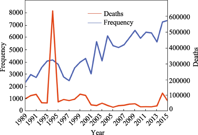
Figure 1 The number and frequency of injured persons caused by armed conflicts worldwide (1989-2015)

4 Methods for geopolitical events simulating and forecasting

4.1 Identifying the characteristics of the GES actors

The characteristics of GES operators, countries and international organizations, may significantly influence the progress of the GES. Alesina et al. (2010) suggested that the size of a nation was determined by the trade-off between scale economies and the costs of population heterogeneity that favor smaller countries. Klaus Desmet et al. (2011) quantitatively explored the breakup of nations in the EU region. The nations were characterized as a set, which consisted of multiple regions with cultural or economic heterogeneity. They used cultural distance and income distance as the main driving forces and found that ‘economic differences’ determined the order of disintegration and ‘cultural differences’ were the keys to the national instability (Miller, 2016). Recent studies revealed that a terrorist activity could be conceptualized as a social network and, in turn, a terrorist network. Simulation of a terrorist-organization structure may help to understand its properties and characteristic actions (Joshua, 2012). Kiruthiga et al. (2015) described the hub-spoke terrorist organization structure with a graphical, computer-aided, experimental modeling method. Clauset and Gleditsch (2012) identified the principle of terrorist attacks. They found that the influences of violent events tended to accelerate with increased size and experience. To address the patterns of the Islamic State of Iraq and Levant (ISIL) related to terrorism, a recently published report from START classified the terrorist attacks into four ISIL-related perpetrator categories: ISIL predecessor, ISIL, ISIL affiliate and ISIL-inspired. The report illustrated the variations of ISIL-related terrorism over time and space (Miller, 2016).
In recent years, agent-based models have been widely adopted to simulate actions of nations in the world. Cederman et al. (2012) established the GeoSim, which is a model family which can well explain geopolitical phenomena. Weidmann and Girardin (2006) presented a software toolbox GROWLab (Geographic Research on War Laboratory), which provides a set of tools to support GES research.

4.2 Simulating and forecasting the geopolitical events

Quite a few previous studies indicated that geopolitical events occurred in non-random ways (White et al., 2013). A special section was published in Science in early 2017 for discussing the prediction and its limits. Ryan Kennedy et al. (2017) believed that with the aid of new techniques and data sources, elections and other geopolitical events will be predictable. Jasny and Stone (2017) developed prediction models using a dataset covering 86 nations and more than 500 elections. The results indicated that their method could predict 80% to 90% of elections in out-of-sample tests.
Climate variability has been considered to have a close relationship with armed conflict. Nina von Uexkull assessed the relationship between civil conflict and growing-season drought. They found that for agriculturally dependent groups and politically excluded groups in poverty-stricken nations, a local drought is found to increase the risk of social violence (Von et al., 2016). Hsiang et al. (2013) quantified the impacts of climate on the social conflict. The results indicated that variation of precipitation and temperature systematically increased the probability of local conflict.
Literatures on the characters of conflicts and their relation to socio-economic conditions increased quickly in recent years. Economic elements, such as oil scarcity, may become the driving forces for geopolitical violence (Cotet and Tsui, 2013; Schneider and Troeger, 2011). Funke et al. (2015) studied the political fall-out from systemic financial crises over the past 140 years based on a long time series dataset of about 800 elections. The result indicated that far-right parties increased their vote share by 30% after a financial crisis; José Noguera-Santaella (2016) conducted a time series analysis to examine the influences of 32 geopolitical incidents on real oil prices from the American Civil War (1859) to the Arab Spring episodes (2011). The results suggested that geopolitical incidents influenced oil prices positively before 2000 but had little impact afterward.
In 2013, Mayer-Schonberger and Cukier (2013) noted that the development of big data will have a dramatic impact on the economy, science, and society as a whole. Big data analysis based on intensive data has become the fourth paradigm of scientific research. In addition to mathematic modeling, the big data method has proven to be an efficient alternative approach for GES simulation (Fernández-Delgado et al., 2014). Based on the dataset from the GTD, White et al. (2013) presented an empirical method for exploring terrorist activity from 2000 to 2010 in three Southeast Asian countries including Indonesia, the Philippines and Thailand. One of the main shackles of big data based modeling is identifying valuable information from noise (Jasny and Stone, 2017). Machine learning is good at handling enormous numbers of predictors and combining them in a nonlinear and highly interactive way (Athey, 2017). Data mining and machine learning methods, which take into account both physical and socio-economic datasets, have proven to be more efficient for forecasting geopolitical incidents. Gao et al. (2013) presented a data-mining approach for modeling geopolitical incidents. This method used prospective space-time scan statistics and could detect outbreaks of terrorist events at an early stage. Ding et al. (2017) demonstrated a deep learning method to evaluate risks of terrorist attacks on a global scale based on GTD dataset and other multiple resources datasets. The method performed well in predicting the terrorism incidents with a precision of 96.6%.

5 Conclusions

It has been more than a century since the origination of the concepts of geopolitics and political geography. Today, the theory of GES, which pays much attention to the integration and interdisciplinary study, has developed rapidly. According to the demands of application and the new advance in GEP and related techniques, the core topics of GES science may include issues as follows:
(1) Data acquisition technologies. It is necessary to establish a seamless observation system for geopolitical elements by combining multiple data acquisition approaches. Geographical Information System (GIS), along with remote sensing and other spatial information techniques, will play an important role for geopolitical data management, data mining and data visualization.
(2) Principles of the interactions between multiple subsystems (or factors) at different scales. These principles not only include the interactions between the five Earth spheres but also the global flows of people, resources and information.
(3) Evaluating and mitigating the global geopolitical risks, including the political, economic, social, environmental and technological risks.
(4) Forecasting the geopolitical events with machine learning and artificial intelligence techniques. The existing physical models, such as the land surface model, climate model and ocean model, should be coupled at regional and global scales. Additionally, the socio-economic models, including international trade, urban development, etc., should also be simulated.
With the progress of related science and technologies, the aforementioned techniques will play significant roles in geopolitical system research.

The authors have declared that no competing interests exist.

[1]
Alesina A, Easterly W, Matuszeski J, 2010. Artificial states.Journal of the European Economic Association, 9(2): 246-277.

[2]
Athey S, 2017. Beyond prediction: Using big data for policy problems.Science, 355: 483-485.Machine-learning prediction methods have been extremely productive in applications ranging from medicine to allocating fire and health inspectors in cities. However, there are a number of gaps between making a prediction and making a decision, and underlying assumptions need to be understood in order to optimize data-driven decision-making.

DOI PMID

[3]
Bertalanffy L V, 1972. The history and status of general systems theory.The Academy of Management Journal, 15(4): 407-426.The article presents a history of general systems theory and discusses several of its various aspects. According to the author, the notion of general systems theory first stemmed from the pre-Socratic philosophers, and evolved throughout the ages through different philosophic entities until it was eventually formally structured in the early 1900s. The theory has three main aspects. The first is called "systems science," or the scientific exploration and theory of systems in various sciences. The second is called "systems technology," or the problems arising in modern technology and society. The third aspect is called "systems philosophy" and refers to the reorientation of thought and world view.

DOI

[4]
Bertalanffy L V, 1987. The History and Status of General Systems Theory. Beijing: Tsinghua University Press.

[5]
Brzezinski Z, 2012. Big Chess: U.S. Primacy and its Geopolitical Strategy. Shanghai: Shanghai People’s Publishing House.

[6]
Cederman L E, 2002. Endogenizing geopolitical boundaries with agent-based modeling.Proceedings of the National Academy, 99(Suppl. 3): 7796-7303.

[7]
Chen S H, 2009. On the geopolitics and geoeconomics in the game between countries.Wuhan University of Technology (Social Science Edition), 22(3): 36-40. (in Chinese)Within the current political format,there are various interest related games between each country.At the same time,the geopolitics and geoeconomics become the main strategies and tools which safeguard and decide national interests.Although strength is the main factor to determine the status of a country,the events that wrong strategies have resulted in the decline or even the extinction of countries are not uncommon in the history.Now the world is in a period of accelerating globalization.The world politics has not only the traditional geopolitical factors,but geoeconomics has the rapid rise.So interstate game has become more complex,and how to deal with the relationship between geopolitics and geoeconomics in the complex situation is an important factor in the survival and development of the state.

[8]
Clauset A, Gleditsch K S, 2012. The developmental dynamics of terrorist organizations.Plos One, 7(11): e48633. doi: 10.1371/journal.pone.0048633.We identify robust statistical patterns in the frequency and severity of violent attacks by terrorist organizations as they grow and age. Using group-level static and dynamic analyses of terrorist events worldwide from 1968 2008 and a simulation model of organizational dynamics, we show that the production of violent events tends to accelerate with increasing size and experience. This coupling of frequency, experience and size arises from a fundamental positive feedback loop in which attacks lead to growth which leads to increased production of new attacks. In contrast, event severity is independent of both size and experience. Thus larger, more experienced organizations are more deadly because they attack more frequently, not because their attacks are more deadly, and large events are equally likely to come from large and small organizations. These results hold across political ideologies and time, suggesting that the frequency and severity of terrorism may be constrained by fundamental processes.

DOI PMID

[9]
Cohen S B, 2014. Geopolitics: The Geography of International Relations. Shanghai: Shanghai Academy of Social Sciences Press.

[10]
Cotet A M, Tsui K K, 2013. Oil and conflict: What does the cross country evidence really show?.American Economic Journal: Macroeconomics, 5(1): 49-80.This paper re-examines the effect of oil wealth on political violence. Using a unique historical panel dataset of oil discoveries, we show that simply controlling for country fixed effects removes the statistical association between the value of oil reserves and civil war onset. Other macro-political violence measures, such as coup attempts, are also uncorrelated with oil wealth. To further address endogeneity concerns, we exploit changes in oil reserves due to randomness in the success of oil explorations. We find little robust evidence that oil discoveries increase the likelihood of political violence. Rather, oil discoveries increase military spending in nondemocratic countries.

DOI

[11]
Daras N J, Mazis J T, 2015. Systemic geopolitical modeling. Part 1: Prediction of geopolitical events.GeoJournal, 80(5): 653-678.We give two general mathematical models predicting geopolitical events into a geopolitical system according to Mazis lakatosian formulation methodology for a Systemic Geopolitical Analysis. To this end, we consider weighted geopolitical indices and their measurements. When the weighted geopolitical indices, as well as the related geopolitical measurements take values in different times and different geographical points, then they form two sets in the four-dimensional Euclidean space. The distance between these sets can be considered as a measure for assessing the occurrence or not of a geopolitical event. To this direction, we give general frameworks of two algorithms for determining the time moments and geographical points at which is expected the appearance of peculiar geopolitical events.

DOI

[12]
Desmet K, Breton M L, Ortuño-Ortín Iet al., 2011. The stability and breakup of nations: A quantitative analysis.Journal of Economy Growth, 16(3): 183-213.This paper quantitatively analyzes the stability and breakup of nations. The tradeoff between increasing returns in the provision of public goods and the costs of greater cultural heterogeneity mediates agents' preferences over different geographical configurations, thus determining the likelihood of secessions and unions. After calibrating the model to Europe, we identify the regions prone to secession and the countries most likely to merge.We then estimate the implied monetary gains from EU membership. As a test of the theory, we show that the model can account for the breakup of Yugoslavia and the dynamics of its disintegration. We find that economic differences between the Yugoslav republics determined the order of disintegration, but cultural differences, though small, were key to the country's instability. The paper also provides empirical support for the use of genetic distances as a proxy for cultural heterogeneity.

DOI

[13]
Ding F Y, Ge Q S, Jiang Det al., 2017. Understanding the dynamics of terrorism events with multiple-discipline datasets and machine learning approach.Plos One, 12(6): e0179057.Terror events can cause profound consequences for the whole society. Finding out the regularity of terrorist attacks has important meaning for the global counter-terrorism strategy. In the present study, we demonstrate a novel method using relatively popular and robust machine learning methods to simulate the risk of terrorist attacks at a global scale based on multiple resources, long time series and globally distributed datasets. Historical data from 1970 to 2015 was adopted to train and evaluate machine learning models. The model performed fairly well in predicting the places where terror events might occur in 2015, with a success rate of 96.6%. Moreover, it is noteworthy that the model with optimized tuning parameter values successfully predicted 2,037 terrorism event locations where a terrorist attack had never happened before.

DOI PMID

[14]
Erickson A S, Goldstein L J, Li N, 2014. China, the United States, and 21st Century Sea Power .Beijing: China Ocean Press.

[15]
Evans G, Newnham J, 1998. The Penguin Dictionary of International Relations .London: Penguin Books Press.

[16]
Fernández-Delgado M, Cernadas E, Barro Set al., 2014. Do we need hundreds of classifiers to solve real world classification problems?.Journal of Machine Learning Research, 15(1): 3133-3181.

[17]
Funke M, Schularik M, Trebesch C, 2015. Going to extremes: Politics after financial crisis, 1870-2014. CESifo Working paper No.5553..

[18]
Future Earth, 2017. Research for global sustainability.Research for global sustainability..

[19]
Gao P, Guo D S, Liao Ket al., 2013. Early detection of terrorism outbreaks using prospective space-time scan statistics.The Professional Geographer, 65(4): 676-691.Terrorism is a complex phenomenon with high uncertainty involving a myriad of dynamic known and unknown factors. It is and will remain a challenge to predict or detect terrorism outbreaks at an early stage. This research presents an alternative approach for modeling terrorism activity, one that monitors and detects space–time clusters of terrorist incidents using prospective space–time scan statistics. Such clusters provide indicators of potential outbreaks of terrorist incidents. To evaluate the effectiveness of the approach, we analyze the terrorist incidents in the Consortium for the Study of Terrorism and Responses to Terrorism's (START) Global Terrorism Database (GTD) from 1998 to 2004. Clusters of terrorist events are detected at each time stamp and life trajectories of these clusters are constructed based on their space–time relationship to each other. Through the life trajectories and trends of clusters, we demonstrate how space–time scan statistics detect terrorism outbreaks at an early stage.

DOI

[20]
Ge Quansheng, Jiang Dong, Lu Fenget al., 2017. Views on the study of geopolitical environment system simulation.Acta Geographica Sinica, 72(3): 371-381. (in Chinese)The term of geopolitical environment refers to the combination of both natural and social environment.Geopolitical environment system is a gigantic and complex system which consists of physical element(e.g.topography,geomorphology,water and land resources,meteorological conditions,etc.)and social economic elements(society,ethic,culture,politics etc.).The research of the geopolitical environment system simulation is a scientific support to the understanding of the international geostrategic dynamics and successfully implement the national strategy.In recent years,the connotation and extension of the geopolitical environment system research have changed dramatically due to the international geo-strategic shift,the global economy and technical progress.This paper presents a review of the origin and development of the geopolitical theory,from classical geopolitics before World War Two to the geopolitics during the cold war period,and the geopolitical researches in post-cold war era.The integration of geopolitics and earth system sciences has brought new advances both in the disciplines and methodology in these areas.The key issues of the simulation of the geopolitical environment system include the dynamic changes of the geopolitical factors,the interaction and adaption of the multiple geopolitical environment factors,methods for establishing the geopolitical environment system and virtual geographical environment techniques.The results indicated that faced with these complicated nonlinear problems like"geopolitical environment system",the hierarchical,reasonable generalization of the model and the numerical approximation methods can achieve the results of quantitative analysis for specific geopolitical issues.Meanwhile,the big data technology is increasingly providing a new paradigm for the studies of geopolitical system.By the methods of heterogeneous data mining,machine learning and high-performance computing,it is expected to explore the associated relationships among the elements contained in the geopolitical environment system to forecast and intervene in the geopolitical environment system evolution,and to provide a new technical method for the solutions to geopolitical issues.

DOI

[21]
Ge Quansheng, Wang Fang, Chen Panqinet al., 2007. Review on global change research. Advances in Earth Science, 22(4): 417-427. (in Chinese)The updated implementation strategy and investigation priority of ESSP,IGBP,WCRP,IHDP and DIVERSITAS in the field of global environmental change(GEC) are introduced.Based on synthetically analysis of GEC research,the phase progress on GEC is summarized,and the characteristics and trend of GEC research are analyzed.

DOI

[22]
GEA, 2012. Global Energy Assessment: Toward a Sustainable Future. Cambridge, UK and New York, NY, USA: Cambridge University Press, and the International Institute for Applied Systems Analysis, Laxenburg, Austria.

[23]
Hirsch M W, Smale S, Devaney R L, 2008. Different Equation, Dynamical System and an Introduction to Chaos. Beijing: Posts and Telecom Press.

[24]
Hsiang S M, Burke M, Miguel E, 2013. Quantifying the Influence of Climate on Human Conflict.Science, 341(6151): 1212.A rapidly growing body of research examines whether human conflict can be affected by climatic changes. Drawing from archaeology, criminology, economics, geography, history, political science, and psychology, we assemble and analyze the 60 most rigorous quantitative studies and document, for the first time, a striking convergence of results. We find strong causal evidence linking climatic events to human conflict across a range of spatial and temporal scales and across all major regions of the world. The magnitude of climate's influence is substantial: for each one standard deviation (1 sigma) change in climate toward warmer temperatures or more extreme rainfall, median estimates indicate that the frequency of interpersonal violence rises 4% and the frequency of intergroup conflict rises 14%. Because locations throughout the inhabited world are expected to warm 2 sigma to 4 sigma by 2050, amplified rates of human conflict could represent a large and critical impact of anthropogenic climate change.

DOI PMID

[25]
Jasny B R, Stone R, 2017. Prediction and its limits.Science, 355(6324): 468-469.

DOI

[26]
Joshua K, 2012. A basic model explaining terrorist group organizational structure.Studies in Conflict & Terrorism, 35(11): 810-830.Terrorist groups strive to balance efficiency with their need for security. This article examines the factors that affect a group's choice of organizational structure. I classify 254 groups from the Global Terrorism Database into one of four basic structures: market, all-channel, hub-spoke, or bureaucracy. The results of a multinomial logistic regression reveal that as secret organizations, terrorist groups are not just driven by achieving efficiencies in their organization but rather by protecting against infiltration and threats. Internal factors such as target selection, operational pace, ideology, and stated goals shape a group's structure. External environmental factors such as political rights, civil liberties, polity durability, and state wealth also help shape a group's structure.

DOI

[27]
Kennedy R, Wojcik S, Lazer D, 2017. Improving election prediction internationally.Science, 355(6324): 515-520.Abstract This study reports the results of a multiyear program to predict direct executive elections in a variety of countries from globally pooled data. We developed prediction models by means of an election data set covering 86 countries and more than 500 elections, and a separate data set with extensive polling data from 146 election rounds. We also participated in two live forecasting experiments. Our models correctly predicted 80 to 90% of elections in out-of-sample tests. The results suggest that global elections can be successfully modeled and that they are likely to become more predictable as more information becomes available in future elections. The results provide strong evidence for the impact of political institutions and incumbent advantage. They also provide evidence to support contentions about the importance of international linkage and aid. Direct evidence for economic indicators as predictors of election outcomes is relatively weak. The results suggest that, with some adjustments, global polling is a robust predictor of election outcomes, even in developing states. Implications of these findings after the latest U.S. presidential election are discussed. Copyright 2017, American Association for the Advancement of Science.

DOI PMID

[28]
Kim H M, 2010. Comparing measures of national power.International Political Science Review, 31(4): 405-427.

DOI

[29]
Kiruthiga A, Bose S, Buvaneswari N, 2015. An experimental simulation of hub-spoke terrorist organizational structure.Advances in Natural and Applied Sciences, 9(9): 41-44.

[30]
Kissinger H, 2012. Big Diplomacy. Hainan: Hainan Press.

[31]
Kong X H, 2010. Analyze on ways of geopolitics affecting a state’s security strategy.World Regional Studies, 19(2): 19-26. (in Chinese)

[32]
Lu Dadao, Du Debin, 2013. Some thoughts on the strengthening of geopolitical and geoeconomic studies.Acta Geographica Sinica, 68(6): 723-727. (in Chinese)The rise and fall of the great powers undoubtedly is not dominated by geo-political and geo-economic rules. Since the end of the Cold War, with the rapid economic development of China and other emerging countries, the international power structure is undergoing profound restructuring and the world is entering the new geo-political and geo-economic era. At present, China's geopolitical environment has become increasingly complex and its peaceful development urgently needs geopolitical and geo-economic theoretical support. Based on analysis of the current world geopolitical and geo-economic development trend, this paper discusses the ideological origins on the fundamental role of geography in the development of geopolitics and geo-economics; analyzes the deficiencies of the Chinese geographers in the field of geopolitics and geo-economics; and then puts forward some suggestions how to strengthen the geopolitical geo-economic studies.

[33]
Mackinder H J, 1904. The geographical pivot of history.Geographical Journal, 23(4): 421-437.Cohousing schemes were evolved as alternative housing to reduce housework for working women, and to reduce loneliness of elderly people by promoting active mutual relationship with community residents in northern European countries. This article discusses how residents manage their life in senior cohousing projects in Sweden and Denmark. The purpose of this study is to investigate residents' life satisfaction connected with demographic characteristics of residents, physical environment and common activities in the senior cohousing communities, so that it could offer usable information for the establishment of new senior cohousing projects in other countries as well as an empirical evaluation of the existing projects in Scandinavian countries themselves. important variables influential to residents' life satisfaction are also discussed in order to improve senior citizens' quality of life. The methods used for the study are literature review, interviews, field trips and questionnaire. Wine hundred and thirty-five postal questionnares were sent to 28 senior cohousing communities throughout Denmark and Sweden. Of those 536 replies were collected and analysed by SPSS program using frequency, mean and Chi-square test. As a result, it was found out that most of the respondents are healthy, 70-year-olds, and satisfied with their current living in the community. The majority of them also would like to strongly recommend others to move to senior cohousing schemes to improve quality of life in their later years. Residents' intensive concern about building location and design is a noteworthy reminder for designers and architects as well as for professionals and decision-makers who work in the elderly welfare sector.

DOI

[34]
Mahan A T, 2006. The Influence of Sea Power upon History. Beijing: The People’s Liberation Army Press.

[35]
Mao H Y, 2013. Geopolitical and geoeconomic situation in the surrounding areas and China’s strategies.Progress in Geography, 33(3): 289-302. (in Chinese)

[36]
Ma X, Fox P, Tilmes Cet al., 2014. Capturing and presenting provenance of global change information.Nature Climate Change, 4(6): 409-413.Global change information demands access to data sources and well-documented provenance to provide the evidence needed to build confidence in scientific conclusions and decision making. A new generation of web technology, the Semantic Web, provides tools for that purpose.

DOI

[37]
Mayer-Schonberger V, Cukier K, 2013. Big Data: A Revolution That Will Transform How We Live, Work, and Think. Eamon Dolan / Houghton Mifflin Harcourt.

[38]
Mazis I T, 2014. Methodology for systemic geopolitical analysis according to the Lakatosian model [D]. Turkey:Istanbul University.

[39]
Miller E, 2016. Patterns of Islamic State-related Terrorism, 2002-2015. START Background Report.

[40]
Muñoz B, García-Verdugo J, San-Martín E, 2015. Quantifying the geopolitical dimension of energy risks: A tool for energy modeling and planning.Energy, 82: 479-500.61We quantitatively estimate the multidimensional geopolitical risk of energy supply.61Factor analysis was used to reveal energy risk, a variable not directly observable.61Advanced economies with energy resources present the lowest level of energy risk.61Less-developed countries obtain high risk values even when they are energy producers.61The proposed index can be used for energy planning and energy management purposes.

DOI

[41]
Noguera-Santaella J, 2016. Geopolitics and the oil price.Economic Modeling, 52: 301-309.61We inquire into the relationship between armed and civil conflicts and oil prices.61We conduct a time series analysis using monthly data since 1859.61We consider the effect of 32 different geopolitical conflicts on oil prices.61Geopolitical events have strongly affected volatility but not much the mean.61Geopolitical events have had significant effects on volatility before 2000.

DOI

[42]
Painter J, 1995. Politics, Geography and ‘Political Geography’: A Critical Perspective. London: Arnold Press.

[43]
Qin D H, 2014. Climate change science and sustainable development.Progress in Geography, 33(7): 874-883. (in Chinese)Since the Fourth Assessment Report(AR4) was released by the Intergovernmental Panel on Climate Change(IPCC) in 2007, new observations have further proved that the warming of the global climate system is unequivocal. Each of the last three successive decades before 2012 has been successively warmer at global mean surface temperature than any preceding decade since 1850. 1983-2012 was likely the warmest 30-year period of the last 1400 years. From 1998 to 2012, the rate of warming of the global land surface slowed down, but it did not reflect the long- term trends in climate change. The ocean has warmed, and the upper 75 m of the ocean warmed by more than 0.11 per decade since 1970. Over the period of 1971 to 2010, 93% of the net energy increase in the Earth's climate system was stored in the oceans. The rate of global mean sea level rise has accelerated, which was up to 3.2 mm yr-1between 1993 and 2010. Anthropogenic global ocean carbon stocks were likely to have increased and caused acidification of the ocean surface water. Since 1971, the glaciers and the Greenland and Antarctic ice sheets have been losing mass. Since 1979, the Arctic sea ice extent deceased at 3.5% to 4.1%per decade, and the Antarctic sea ice extent in the same period increased by 1.2% to 1.8% per decade. The extent of the Northern Hemisphere snow cover has decreased. Since the early 1980s, the permafrost temperatures have increased in most regions. Human influence has been detected in the warming of the atmosphere and the ocean,changes in the water cycle, reductions in snow and ice, global mean sea level rise, and changes in climate extremes. The largest contribution to the increase in the anthropogenic radiative forcing was by the increase in the atmospheric concentration of CO2since 1750. It led to more than half of global warming since the 1950s(with95 % confidence). It is predicted using Coupled Model Intercomparison Project Phase 5(CMIP5) and Representative Concentration Pathways(RCPs) that the global mean surface temperature will continue to rise for the end of this century, the frequency of extreme events such as heat waves and heavy precipitation will increase, and precipitation will present a trend of "the dry becomes drier, the wet becomes wetter". The temperature of the upper ocean will increase by 0.6 to 2.0 compared to the period of 1986 to 2005, heat will penetrate from the surface to the deep ocean which will affect ocean circulation, and sea level will rise by 0.26 to 0.82 m in 2100.Cryosphere will continue to warm. To control global warming, humans need to reduce the greenhouse gas emissions. If the increase in temperature is higher than 2 than before industrialization, the mean annual economic losses worldwide will reach 0.2% to 2.0% of income, and cause large-scale irreversible effects, including death,disease, food insecurity, inland flooding and water logging, and rural drinking water and irrigation difficulties that affect human security. If taking prompt actions, however, it is still possible to limit the increase in temperature within 2 . To curb the gradually out-of-control global warming and achieve the goal of sustainable development of the human society, global efforts to reduce emissions are needed.

[44]
Schneider G, Troeger V E, 2011. War and the world economy: Stock market reactions to international conflicts.Journal of Peace Research, 48: 481-495.While the negative economic consequences of civil conflict are well known, does civil conflict have sector-specific effects that threaten food and economic security? This article surveys the effects of civil conflict on reported marine and inland fish catch, focusing on the effects of conflict through redeployment of labor, population displacement, counter-insurgency strategy and tactics, and third-party encroachment into territorial waters. Analysis of 123 countries from 1952 to 2004 demonstrates a strong, statistically robust and negative relationship between civil conflict and fisheries, with civil wars (1000+ battle deaths) depressing catch by over 16% relative to prewar levels. The magnitude of this effect is large: the cumulative contraction in total fish catch associated with civil war onset is roughly 13 times larger than the estimated effect of an extraordinarily strong El Ni o, the ocean-atmosphere phenomenon associated with global declines in fisheries. Robust evidence of a Phoenix effect is lacking: post-conflict fisheries do not quickly bounce back to prewar catch levels due to more rapid growth. Analysis of conflict episodes indicates that conflict intensity, measured by battle deaths, negatively affects fish catch, while population displacement and conflict proximity to the coast do not. While these findings contribute to the growing literature on the economic effects of civil conflict, they also are important for regional fisheries management organizations, which must increasingly pay attention to sociopolitical factors that dramatically affect the utilization of aquatic resources.

DOI

[45]
Seversky A D, 1950. Air Power: Key to Survial. New York: Simon and Schuster Press.

[46]
Spykman N J, 1965. The Geography of the Peace. Beijing: The Commercial Press.

[47]
UNEP GEO, 2017. Keeping the global environment under review. Keeping the global environment under review. .

[48]
Von U N, Croicu M, Fjelde Het al., 2016. Civil conflict sensitivity to growing-season drought.Proceedings of the National Academy, 113(44): 12391-12396.To date, the research community has failed to reach a consensus on the nature and significance of the relationship between climate variability and armed conflict. We argue that progress has been hampered by insufficient attention paid to the context in which droughts and other climatic extremes may increase the risk of violent mobilization. Addressing this shortcoming, this study presents an actor-oriented analysis of the drought-conflict relationship, focusing specifically on politically relevant ethnic groups and their sensitivity to growing-season drought under various political and socioeconomic contexts. To this end, we draw on new conflict event data that cover Asia and Africa, 1989-2014, updated spatial ethnic settlement data, and remote sensing data on agricultural land use. Our procedure allows quantifying, for each ethnic group, drought conditions during the growing season of the locally dominant crop. A comprehensive set of multilevel mixed effects models that account for the groups' livelihood, economic, and political vulnerabilities reveals that a drought under most conditions has little effect on the short-term risk that a group challenges the state by military means. However, for agriculturally dependent groups as well as politically excluded groups in very poor countries, a local drought is found to increase the likelihood of sustained violence. We interpret this as evidence of the reciprocal relationship between drought and conflict, whereby each phenomenon makes a group more vulnerable to the other.

DOI PMID

[49]
Weidmann N B, Girardin L, 2006. GROWLab: A Toolbox for Social Simulation, .

[50]
White G, Porter M D, Mazerolle L, 2013. Terrorism risk, resilience and volatility: A comparison of terrorism patterns in three Southeast Asian countries.Journal of Quantitative Criminology, 29(2): 295-320.AbstractObjectiveThis article explores patterns of terrorist activity over the period from 2000 through 2010 across three target countries: Indonesia, the Philippines and Thailand.MethodsWe use self-exciting point process models to create interpretable and replicable metrics for three key terrorism concepts: risk, resilience and volatility, as defined in the context of terrorist activity.ResultsAnalysis of the data shows significant and important differences in the risk, volatility and resilience metrics over time across the three countries. For the three countries analysed, we show that risk varied on a scale from 0.005 to 1.61 “expected terrorist attacks per day”, volatility ranged from 0.820 to 0.994 “additional attacks caused by each attack”, and resilience, as measured by the number of days until risk subsides to a pre-attack level, ranged from 19 to 3902days. We find that of the three countries, Indonesia had the lowest average risk and volatility, and the highest level of resilience, indicative of the relatively sporadic nature of terrorist activity in Indonesia. The high terrorism risk and low resilience in the Philippines was a function of the more intense, less clustered pattern of terrorism than what was evident in Indonesia.ConclusionsMathematical models hold great promise for creating replicable, reliable and interpretable “metrics” to key terrorism concepts such as risk, resilience and volatility.

DOI

[51]
World Economic Forum (WEF), 2017. The Global Risks Report ,. The Global Risks Report 2017. (accessed November, 2017 .

[52]
Xin W, 2016. China highly evaluates Russia's new national security strategy and positive statement on Sino-Russian relations. China highly evaluates Russia's new national security strategy and positive statement on Sino-Russian relations.accessed November, 2017. .

[53]
Zheng D, Chen S P, 2001. Progress and disciplinary frontiers of geographical research. Advance in Earth Sciences, 16(5): 599-605. (in Chinese)Geography is a science specializing in the study of the interaction between natural and human elements on the Earth surface and their space and time regular patterns. In nature, it is an inter discipline possessed of the characters innate to natural sciences and social sciences alike and features both integration and regionality. Contemporary geography includes physical geography, human geography and geo informatics. The achievements attained in the 20th century are listed as following:laws on regional differentiation revealed and exploration of regional systems, a comprehensive study of natural processes taking place on the Earth's surface, the man nature system and regional development research, compilation of various cartographic works in series such as national albums of maps and atlases, development and application of the geographic information system (GIS). Development trends in geographical research features the following aspects: transdisciplinary intersection, infiltration and interdisciplinary fusion with various adjacent disciplines, enhancement of integrated studies within geography itself, further deepening of microscopic studies on geographical processes, the expansion of applied research fields, the modernization of experimental geography and related technical means, change in theoretical thinking models etc. In order to promote development of the Earth system science and to coordinate man nature relationship, geographers may make contributions to the following research frontiers: a comprehensive study on the processes and spatial patterns of the terrestrial surface, global change and regional responses to it, guarantees of natural resources and ecosystem reconstruction, sustainable regional development, mechanism of man nature relationship and regulations, geo informatics and strategies of digital Earth research, etc.

DOI

Outlines

/