Research Articles

The relationship between water level change and river channel geometry adjustment in the downstream of the Three Gorges Dam

  • YANG Yunping , 1, 2 ,
  • ZHANG Mingjin 2 ,
  • SUN Zhaohua 1 ,
  • HAN Jianqiao , 3, * ,
  • Wang Jianjun 2
Expand
  • 1. State Key Laboratory of Water Resources and Hydropower Engineering Science, Wuhan University, Wuhan 430072, China
  • 2. Key Laboratory of Engineering Sediment, Tianjin Research Institute for Water Transport Engineering, Ministry of Transport, Tianjin 300456, China
  • 3. Institute of Soil and Water Conservation, Northwest Agriculture and Forestry University, Yangling 712100, Shaanxi, China
Corresponding author:Han Jianqiao (1987-), PhD, E-mail:

Author: Yang Yunping (1985-), PhD, specialized in estuary and coastal evolution and causes. E-mail:

Received date: 2017-02-21

  Accepted date: 2017-03-31

  Online published: 2018-12-20

Supported by

National Key Research and Development Program of China, No.2016YFC0402106; National Natural Science Foundation of China, No.51579123, No.51579185, No.51339001; Supported by the Open Research Fund Program of State Key Laboratory of Water Resources and Hydropower Engineering Science, No.2016HLG02; Fundamental Research Funds for Central Welfare Research Institutes, No.TKS160103

Copyright

Journal of Geographical Sciences, All Rights Reserved

Abstract

In this study, data measured from 1955-2016 were analysed to study the relationship between the water level and river channel geometry adjustment in the downstream of the Three Gorges Dam (TGD) after the impoundment of the dam. The results highlight the following facts: (1) for the same flow, the low water level decreased, flood water level changed little, lowest water level increased, and highest water level decreased at the hydrological stations in the downstream of the dam; (2) the distribution of erosion and deposition along the river channel changed from “erosion at channels and deposition at bankfulls” to “erosion at both channels and bankfulls;” the ratio of low-water channel erosion to bankfull channel erosion was 95.5% from October 2002 to October 2015, with variations between different impoundment stages; (3) the low water level decrease slowed down during the channel erosion in the Upper Jingjiang reach and reaches upstream but sped up in the Lower Jingjiang reach and reaches downstream; measures should be taken to prevent the decrease in the channel water level; (4) erosion was the basis for channel dimension upscaling in the middle reaches of the Yangtze River; the low water level decrease was smaller than the thalweg decline; both channel water depth and width increased under the combined effects of channel and waterway regulations; and (5) the geometry of the channels above bankfulls did not significantly change; however, the comprehensive channel resistance increased under the combined effects of riverbed coarsening, beach vegetation, and human activities; as a result, the flood water level increased markedly and moderate flood to high water level phenomena occurred, which should be considered. The Three Gorges Reservoir effectively enhances the flood defense capacity of the middle and lower reaches of the Yangtze River; however, the superposition effect of tributary floods cannot be ruled out.

Cite this article

YANG Yunping , ZHANG Mingjin , SUN Zhaohua , HAN Jianqiao , Wang Jianjun . The relationship between water level change and river channel geometry adjustment in the downstream of the Three Gorges Dam[J]. Journal of Geographical Sciences, 2018 , 28(12) : 1975 -1993 . DOI: 10.1007/s11442-018-1575-9

1 Introduction

The Three Gorges Dam (TGD) Project is the largest water conservation project in human history. It provides comprehensive benefits encompassing flood control, hydropower, shipping, water supply, energy conservation, and emissions reduction (Zheng 2016). The construction and operation of the Three Gorges Reservoir (TGR) has influenced the regulation of the Yangtze River and high/low water levels downstream and attracted the attention of researchers worldwide. From 1950 to 1998, the Yichang-Hankou reach of the Yangtze River mainly underwent a process of siltation. From 2003 to 2007, scouring dominated (
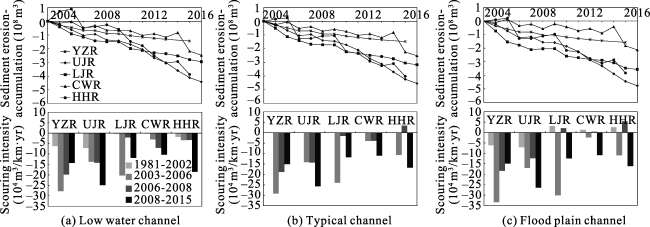
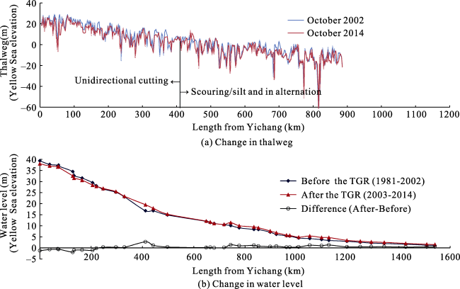
Chen et al., 2010). Based on the comparison of data from 2009 to 2010 with that from 1998 to 2002, there is evidence of deep, one-dimensional undercutting in the 100 km downstream of the dam and alternating siltation and scouring further downstream (Yuan et al., 2012; Dai and Liu, 2013). The distribution of siltation and scouring along the course of the river evolved from “bed scouring and beach building” before water was stored at the TGR to “erosion of both bed and banks” afterwards (Xu et al., 2011, 2012; Dai and Lu, 2014). Scouring is concentrated in the low-water channel (Han et al., 2014) of the Yichang-Chenglingji reach of the river (Xu et al., 2011). Based on the comparison between 2012 and 2002, undercutting was the principal form of scouring in the middle and lower reaches of the Yangtze River. The river’s cross section became deeper and narrower (
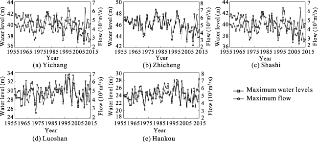
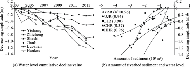
Xu et al., 2013). Existing studies on the channel morphology are mainly based on specific time periods after water was stored at the TGR. Previous studies did not provide a comprehensive analysis reflecting the differences in channel adjustments on the scale of individual reach of the river at different stages of the TGR’s development. Low water levels downstream of the dam are dropping (
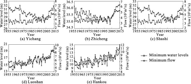
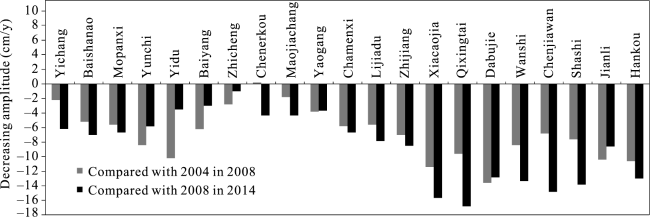
Sun et al., 2015). This effect was anticipated (Lu et al., 2002; Fang et al., 2012) because it occurs downstream of large reservoirs worldwide (Bormann et al., 2011). Worldwide, flood water levels downstream of large reservoirs generally increase slightly or remain unchanged (Bormann et al., 2011). Evaluations of the changes in flood water levels at given flow rates in the time since water has been stored at the TGR are inconclusive. Based on the results of different studies, the flood water levels have decreased (Jiang and Huang, 1997), remained basically unchanged (Li et al., 2009), slightly increased, or significantly increased (Mei et al., 2015; Zhang et al., 2016). Some research indicates that the flood water levels in the river channel downstream from the TGR have not decreased under the influence of clear water released from the reservoir. Instead, the capacity of the Jingjiang reach to divert floodwater to the Dongting Lake and the river’s overall flood discharge capacity have decreased (Mei et al., 2015). From 2003 to 2013, the water level corresponding to a flow rate of Q = 50,000 m3/s at Hankou Station has increased (Mei et al., 2015). Intense scouring of the riverbed is the main cause of the decrease in low water levels. Thickening beaches, narrowing of the flood channel, roughening of the riverbed, and increased riverbank vegetation are the main elements contributing to rises in flood water levels (Moshe et al., 2008; 
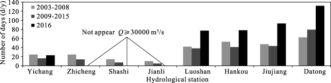
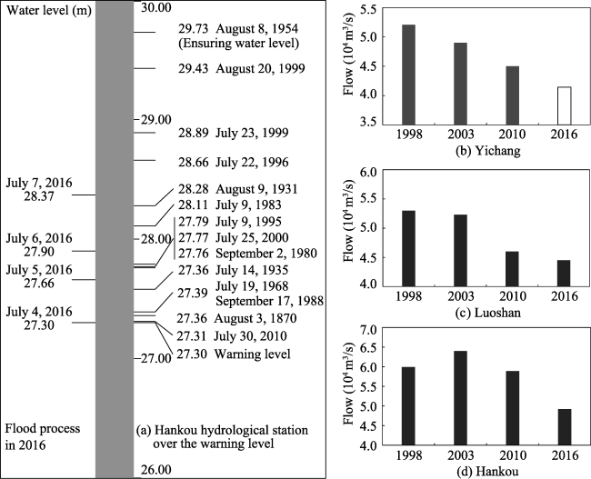
Greene and Knox, 2014). In the time since water has first been stored at the TGR, the channel morphology downstream has changed; the riverbed has become rougher; there are fewer flood days per year; and human activities have increased. The effects of these changes on flood water levels have not been thoroughly examined. Localized flooding occurred between June and August 2016 in the middle and lower reaches of the Yangtze River. Water levels at Luoshan and further downstream exceeded flood warning levels. However, the flow rate corresponding to flood warnings was lower than that of 1998 or 2010. This paper aims to explain the reasons for that.
In summary, there is a lack of research thoroughly describing the overall effects of siltation and scouring downstream of the TGR. How have they affected channel morphology and water levels in different reaches of the river over time? This paper clarifies the processes of riverbed morphology in individual reaches by examining water levels and channel morphology data from 1955 to 2016. It also combines analyses of riverbed and sidewall resistance and human activities that drive changes in fixed flow-rate water levels to evaluate how changing water levels in general affect the flood control situation and depth of the Yangtze River shipping channel.

2 Research zone and water-sediment conditions

2.1 Research zone

The length of the Yichang-Datong reach of the Yangtze River downstream of the TGR is 1183 km. The Yichang-Dabujie reach is a 116.4 km long sandy cobble reach. Downstream of Dabujie is a 1066.4 km long sandy reach (Figure 1). The main stream of the river in the research zone includes the following hydrological stations: Yichang, Zhicheng, Shashi, Jianli, Luoshan, Hankou, Jiujiang, and Datong. Flood diversion channels to the Dongting Lake include Songzikou, Taipingkou, and Ouchikou, which are known as the three outlets of the Dongting Lake. The Xiangjiang, Zishui, Yuanjiang, and Lishui rivers converge at the Dongting Lake. These rivers are known as the four waters of the Dongting Lake. The Chenglingji hydrological station controls the discharge from the Dongting Lake into the main stream of the Yangtze River. The Hanjiang River confluence is controlled by the Huangzhuang Station. The Hukou Station controls the discharge to the river from the Poyang Lake. The Poyang Lake is fed by the Xiushui, Ganjiang, Fuhe, Xinjiang, and Raohe rivers, known as the five rivers.
Figure 1 Schematic of the river sections in the downstream of the TGR

2.2 Data sources

The hydrological stations involved in this study are Yichang, Zhicheng, Shashi, Jianli, Luoshan, Hankou, Jiujiang, and Datong Stations. Also involved are the three diversion channels to the Dongting Lake and the discharge channels from the Dongting and Poyang lakes that are controlled by the Chenglingji and Hukou stations, respectively. The runoff rate, flow rate, sediment transport, and water level information was collected from 1955 to 2016 at each of the hydrological stations. Deposition, erosion, and cross section data were collected from the Yichang-Hukou reach from 1987 to 2014. Water level data were collected along the course of the river in the Yichang-Hukou reach from 1981 to 2014. Information on the depth and width of the shipping channel from 2002 and 2015 was also collected. Data collection times vary, but they all end within the past three years, clearly revealing recent patterns. Table 1 shows the source of each type of data.
Table 1 Sediment source and hydrological data of the downstream of the TGD
Hydrological station and reach Content Period Source
Yichang, Zhicheng, Shashi, Jianli, Hankou, Datong Water, sediment, flow, water level 1955-2016 Yangtze River Middle and
Lower Reaches Hydrological Yearbook
Songzikou, Taipingkou,
Ouchikou, Chenglingji, Hukou, Huangzhuang
Water, sediment, flow
Yichang-Hukou Reach Amount of river sediment 1987-2015
Yichang-Hukou Reach Water level stations 1981-2014 Changjiang Waterway
Planning Design and Research
Institute
Yichang-Yangtze Estuary Depth and width of the shipping channel 2002 and 2015

2.3 Sediment dynamics

2.3.1 Runoff and sediment transport dynamics
From 1955 to 2015, the quantity of runoff at the Yichang and Datong Stations erratically increased and decreased without a clear overall trend. Between 2003 and 2015, the average runoff at the Yichang and Datong Stations was 7.7% and 5.5% lower, respectively, than the average runoff at those stations between 1955 and 2002 (Figure 2a), mainly due to climate change (Yang et al., 2015). The sediment transport showed a decreasing trend from 1955 to 2015, especially between 2003 and 2015 at the Yichang Station (Figure 2b). This is consistent with global trends downstream of large reservoirs (Maren et al., 2013).
Figure 2 Changes of discharge and flux in the downstream of the TGD
2.3.2 Composition of runoff and sediment transport
The relative quantities of runoff at the Datong Station originating from the Yichang Station, Dongting Lake, Hanjiang River, Poyang Lake, and the region in between remained relatively unchanged after water was stored at the TGR (Figure 2c). The proportions of sediment transport varied, on the other hand. In the three time periods before water was stored at the TGR, the sediment at the Datong Station mainly came from the Yichang Station. The Dongting Lake accumulated sediment at a decreasing rate, the proportion of sediment from the Hanjiang River decreased, and the contribution from Poyang Lake stayed close to zero. The main stream of the river had begun to accumulate sediment. After water was stored at the TGR, 29.2% of the sediment at Datong Station originated from Yichang Station. This was a much smaller proportion than during any of the three previous periods. The Dongting Lake changed from sediment sink to sediment source. Its proportion was around 6.8%. The contribution of the Hanjiang River to the total proportion of sediment at Datong was around 4.4%, insignificantly different from the 1955 to 2002 proportion. The proportion from Poyang Lake rose to 10.2%, slightly higher than during all three periods of time before water was stored at the TGR. The main stream of the river overall changed from siltation to scouring. Scoured sediment from the main stream accounted for 49.5% of the sediment transport at Datong Station.

3 Flood water and low water level dynamics downstream of the TGD

3.1 Changes in water levels for the given flow rates

The years 2003, 2012, and 2016 were chosen for comparison (Figure 3). At a given flow rate, the water levels at the Yichang, Zhicheng, Shashi, Jianli, Luoshan, Hankou, and Jiujiang Stations first decreased and then increased. There are critical flow rates at which corresponding water levels began to increase or decrease over time. They are close to the flood stage flow rates corresponding to the reach of the river in which these stations are located. When the river was flooded, the water levels for a given flow rate did not decrease over time, as predicted; they increased. Based on the comparison of 2016 and 2012 with 2003, the difference in flow rates between low water and flood water levels decreased. This means that the magnitude of the flow rates required for flooding gradually decreased.
Figure 3 Relationship between the flow and water level in the lower reaches of the TGD

3.2 Changes of minimum and maximum water levels

3.2.1 Minimum water levels
Before water was stored in the TGR (Figure 4), the minimum water levels at the Yichang, Zhicheng, and Shashi Stations fluctuated, trending downwards. After water was stored, the minimum water levels began to increase. At the Luoshan and Hankou Stations, the minimum water levels have been rising since water has first been stored in the TGR.
Figure 4 Minimum water level at the downstream hydrological station of the TGD
3.2.2 Maximum water levels
Before water was stored in the TGR (Figure 5), the yearly maximum water levels at the Yichang, Zhicheng, and Shashi Stations fluctuated, trending downwards. Since water has been stored, the maximum water levels at these stations have followed no clear pattern; the peaks have been below pre-storage peaks. The maximum water levels at the Luoshan and Hankou Stations slightly increased before water was stored in the TGR; however, no clear trend can be observed currently.
Figure 5 Maximum water level in the downstream hydrological station of the TGD

4 Siltation/scouring dynamics downstream of the TGR

4.1 Changes in riverbed morphology due to siltation/scouring before and after water storage in the TGR

From 1981 to 2002, the Yichang to Hukou reaches of the Yangtze River were scoured at low water levels. Scouring of the Yichang to Zhicheng reaches and Upper Jingjiang reach was concentrated in the low-water channel. Some siltation occurred between the low water level and flood plain. Siltation was observed in the Lower Jingjiang reach and Chenglingji- Hankou and Hankou-Hukou reaches of the Yangtze River. The overall evolutionary trend was “erosion of the channel and deposition in the flood plain.” From 2003 to 2015 (Xu et al., 2011, 2012, 2013), the total quantities of deposition/erosion in the Yichang-Zhicheng reach (YZR), Upper Jingjiang reach (UJR), Lower Jingjiang reach (LJR), Chenglingji-Hankou reach (CHR), and Hankou-Hukou reach (HHR) were -144, -411, -280, -218, and -389 million m3, respectively (Figure 6. Note that data for the Yichang-Zhicheng and Hankou- Hukou reaches from October 2014 to October 2015 are missing). Figure 5 compares the deposition/erosion intensity patterns of different reach of the Yangtze River in the low-water channel, typical river channel, and flood plain channel during three periods (2003-2006, 2006-2008, and 2008-2015), each representing a different water storage level of the TGR. The scouring intensity of each part of the channel in the Yichang-Zhicheng reach decreased over time. In the Upper Jingjiang reach, the scouring intensity increased in low-water and typical river channels. In the flood plain, the scouring intensity first decreased and then increased. In the Lower Jingjiang reach, the scouring intensity first decreased and then increased. There was overall deposition in the flood plain channel between 2006 and 2008. In the Chenglingji-Hankou reach, the scouring intensity generally increased in the low-water and typical channels. In the flood plain, the channel scouring intensity was weak or negative at first but increased later. In the Hankou-Hukou reach, the scouring intensity increased in the low-water channel. In the typical channel and flood plain channel, the scouring first weakened and overall deposition occurred from 2006 to 2008; the scouring intensified later.
Figure 6 Erosion and deposition changes in the channels of the Yichang-Hukou reaches (The flow rates corresponding to the low-water channel, typical channel, and flood plain channel in the figure are 5000 m3/s, 10,000 m3/s, and 30,000 m3/s, respectively, as measured at the Yichang Station.)

4.2 Scouring intensity per unit of river length

From 2003 to 2006, the Yichang-Zhicheng reach had the greatest rate of erosion per unit river length, followed by the Lower Jingjiang reach. The Chenglingji-Hankou reach had the smallest rate. From 2006 to 2008, the Yichang-Zhicheng reach still had the greatest amount of erosion per unit of river length, followed by the Upper Jingjiang reach. The Lower Jingjiang reach had the smallest rate of erosion and the Hankou-Hukou reach had overall deposition. From 2008 to 2015, the erosion was the greatest in the Upper Jingjiang reach, followed by the Hankou-Hukou reach. Therefore, the location of the greatest erosion per unit river length in 2008 to 2015 suddenly changed to the Upper Jingjiang reach after being the Yichang-Zhicheng reach from 2003 to 2008. The intensity of erosion in the Lower Jingjiang reach and further downstream intensified over time as the effects of the release of clear water gradually increased.

4.3 Evolution of the erosion/deposition distribution in the channel

The low-water channel is defined as the deep channel. The low beach confines the channel between the low-water channel and typical channel. The high beach divides the typical channel and flood plain. Table 2 compares the proportional compositions of the total erosion/deposition of the flood plain. The components include the low-water channel, low beach, and high beach. The analysis indicates:
(1) Before water was stored in the TGR, the low-water channels in the Yichang-Zhicheng reach and Upper Jingjiang reach were eroding. The high and low beaches were undergoing slight deposition. The low-water channel in the Lower Jingjiang reach and the Chenglingji-Hankou and Hankou-Hukou reaches of the Yangtze River were eroding. The high and low beaches were experiencing heavy siltation. This indicates “deepening channel and thickening beaches” evolution.
(2) From 2003 to 2008, the low-water channel and high and low beaches of the Yichang-Zhicheng reach and the Upper and Lower Jingjiang reaches were eroding. The Chenglingji-Hankou reach was undergoing the process of “deepening channel and thickening beaches,” just as it was before water was stored in the TGR. The deposition was concentrated in the high beach. In the Hankou-Hukou reach, the low-water channel and low beach were eroding, while the high beach was experiencing slight deposition.
(3) Based on the comparison of 2008 to 2015 with 2003 to 2008, erosion was mainly concentrated in the low-water channel during both periods in the Yichang-Zhicheng and Jingjiang reaches. Beach erosion was less intense or slightly negative. In the Chenglingji-Hankou reach, erosion was concentrated in the low-water channel. The low beach changed from siltation to erosion over time and the rate of siltation in the high beach decreased. In the Hankou-Hukou reach, erosion was concentrated in the low-water channel.
Table 2 Erosion and deposition proportion changes in the Yichang-Hukou reaches
Period of time Reach YZR UJR LJR CHR HHR
Extent (km) 60.8 171.7 175.5 251.0 295.4
1981 to 2002 Low-water channel (%) 102.0 100.6 9.2 17.5 69.6
Low beach (%) -2.0 -0.6 -109.2 -117.5 -169.6
High beach (%)
October 2002 to October 2008 Low-water channel (%) 88.6 89.6 73.2 301.8 60.4
Low beach (%) 1.7 2.2 11.6 -30.7 48.3
High beach (%) 9.6 8.2 15.2 -171.1 -8.7
October 2008 to November 2015 Low-water channel (%) 96.4 94.0 95.4 95.3 115.0
Low beach (%) 4.8 3.1 -0.4 5.8 -11.4
High beach (%) -1.1 2.9 5.0 -1.1 -3.6

Note: Positive values represent erosion ratios and negative values indicate deposition ratios.

The low beach changed from erosion to deposition over time. There was continuous deposition in the high beach zone. Thus, there was a “channel erosion and thickening beaches” evolution.

5 Causes of changing low water levels and their effects on the depth of the waterway

5.1 Relationship between changes in low water levels and siltation/scouring of the channel

An examination of the depth of the channel in the 410 km section of the river downstream of the TGR in October 2014 shows, on average, 1.50 m of undercutting compared with October 2002. Further downstream, alternating siltation and scouring occurred at different locations over the same period (Figure 7a). On average, the low water level of the waterway in the 240 km downstream of the TGR in 2003 to 2014 was 1.10 m lower than between 1981 and 2002. Further downstream, the low water levels rose on average. Undercutting was concentrated in the Yichang-Zhicheng reach and Upper and Lower Jingjiang reaches and the low water level decreases mainly occurred in the Yichang-Zhicheng and Upper Jingjiang reaches (Figure 7b). In the immediate future, the undercutting in the Lower Jingjiang reach should be controlled to prevent low water levels from dropping.
Figure 7 Relationship between the siltation/scouring of the channel and low water level
The analysis of dry-season water levels (measured at a flow rate of Q = 5600 m3/s at Yichang Station) in 2003, 2008, and 2014 indicates that the low water levels between Yichang and Mopanxi and between Chenerkou and Hankou generally dropped more between 2008 and 2014 than between 2003 and 2008. At the same time, the low water levels in the Yunchi to Zhicheng section dropped less between 2008 and 2014 than between 2003 and 2008 (Figure 8). Along the course of the river, the magnitude of the decrease in the low water levels first increases and then decreases. At Zhicheng Station, the magnitude of the decrease in the low water level hits a local minimum and the pattern repeats itself. This indicates that the Zhicheng reach had a node control effect on maintaining the upstream and downstream low water levels. Downstream of Zhicheng, the water levels dropped more and more rapidly. This trend tended to migrate upstream. The upstream effects of water level drops caused by erosion of the low-water channel downstream of Zhicheng Station should be carefully monitored.
Figure 8 Process of water level decline in the Yichang-Hankou reaches
Levels for various reach of the river and siltation/scouring of the channel are well correlated. The low water levels decrease as cumulative erosion increases (Figure 9). In the Yichang-Zhicheng and Upper Jingjiang reaches, the low water level drops less rapidly as the overall quantity of erosion increases, while in the Lower Jingjiang and Chenglingji-Hankou and Hankou-Hukou reaches, the low water levels drop more rapidly as the overall quantity of erosion increases. As the intensity of scouring increases along the Lower Jingjiang reach and downstream of Hukou, there is the possibility that the fixed flow rate of the low water levels will continue to drop.
Figure 9 Amount of dry riverbed and the relationship between the Yichang-Hukou reaches

5.2 The relationship between the low water levels and depth of the waterway

Since water has been stored in the TGR, the depth of the waterway has mainly been controlled by erosion. To prevent adverse effects, such as shoreline collapse, beach and shoal atrophy, and reduction of flow in the main waterway during the dry season, the Yangtze River Waterway Bureau carried out systematic waterway remediation work in the middle and lower reaches of the Yangtze River from 2003 to 2015. As a result, the depth of the waterway increased by 0.50 to 0.60 m in the Yichang-Chenglingji, Chenglingji-Wuhan, and Wuhan-Anqing reaches, from 2.9 m, 3.2 m, and 4.0 m (2003) to 3.5 m, 3.7 m, and 4.5 m (2015), respectively (Figure 10). The width of the waterway also increased significantly. Thus, in 2015, the dimensions of the waterway had already increased to the target dimensions for 2020 (Cao et al., 2010; Maren et al., 2013; Yang et al., 2017a, 2017b).
Figure 10 Sedimentation in the Dongting and Poyang lakes

6 Causes of changes in flood water levels and analysis of their effects on flood control situation

6.1 Relationships between rivers and lakes and the influence of siltation/scouring of the main stream channel on flood water levels

Siltation occurred in the Dongting Lake region from 1960 to 2006. The overall balance shifted to scouring from 2007 to 2015. In the Poyang Lake region, alternating siltation and scouring occurred from 1960 to 1999. From 2000 to 2015, a scouring trend was observed (Figure 10). Both lakes receive sediment scoured from rivers (Zhu et al., 2015). The scouring in the lake regions increased after water was stored in the TGR. This increased the lakes’ adjustable storage capacity to some extent. Scouring can reduce the lakes’ contribution to flooding of the main stream of the river and the flood control pressure on the main stream. The flow rates at the entrances to the river control the influence of the two lakes on the flooding of the main stream. They also determine if flooding in the middle and lower reaches of the river consists of upstream flood water or a combination of lake water and upstream flood water. However, the rates are not the main determinant of the fixed flow rate flood water levels.
Considering the characteristics of the river itself, the boundary obstructions downstream restrict the release of flood water from the river (Zhang et al., 2009). At flow rates of Q ≥ 50,000 m3/s in the Wuhan-Jiujiang reach, a bottleneck at Tianjiazhen delays the release of flood water by 2-3 days (Shi et al., 2007). It can also cause increased flood water levels upstream. Before water was stored in the TGR, the overall siltation of the main stream of the Yangtze River was the main driver of rising flood water levels at fixed flow rates (Yu et al., 2005; Tang et al., 2010). After water was stored in the TGR, the Yangtze River channel downstream of the TGR began to erode, especially the low-water channel (Figure 6 and Table 2).
Theoretically, this should not only cause decreases in low water levels but also in flood water levels. Scouring of the river channel seems inconsistent with rising flood water levels. Research about the causes of rising flood water levels at fixed flow rates should include changes in the hydraulic resistance and morphology of the riverbed caused by scouring and the effects of human activities.

6.2 Analysis of the causes of changing flood water levels after water was stored in the TGR

After water was stored in the TGR, large-scale scouring and undercutting of the riverbed downstream occurred, but the flood water levels did not decrease as predicted. The adjustment of the water level in the reservoir can reduce the maximum flow rate and help ensure flood control. Soon, the TGR will begin an adjustment schedule aimed at reducing maximum flow rates in the flood season (Zheng 2015). Increasing flood water levels at the medium flood flow rate and the causes of these increases are the main points of concern. This section analyses the rising flood water levels observed at medium flood flow rates since the time at which water has first been stored in the TGR. First, the direct and indirect influences of a rougher riverbed and human activities, such as bank vegetation and port/channel morphology regulation, are analysed.
6.2.1 Effects of a rougher riverbed
A rougher riverbed increases a river’s hydraulic resistance and raises water levels. After water was stored in the TGR, the downstream riverbed became rougher (Yang et al., 2016; Zhang et al., 2017). The median grain size D50 of the surface of the riverbed between Yichang and Zhicheng increased by a factor of 48, from 0.638 mm in December 2003 to 30.4 mm in October 2010. Between Zhicheng and Dabujie (Yangjianao), the median grain size D50 increased by a factor of 20. Han (2014), Yang et al. (2016), and Zhang et al. (2017) calculated increases of 91% for the coarseness values of the riverbed downstream of the TGR, after water was stored (0-61 km, Yichang-Zhicheng reach), 65% (61-111 km, Zhicheng-Dabujie reach), 3% (111-319 km, UJR), and 2% (319-865 km, Chenglingji-Hukou reach; Table 3). Mathematical model calculations show the following (Han, 2014): In the Yichang-Dabujie reach of the river with pebble and gravel, the water levels corresponding to Yichang Station flow rates of 5000, 10,000, 23,000, and 35,000 m3/s increased by an average of 1.57, 2.04, 2.7, and 3.3 m, respectively, after coarsening of the riverbed. This is more than the actual drop in water level due to the increased channel depth corresponding to each flow rate increase. This explains how the coarsening of the riverbed effectively mitigated low water level drops in this pebble and gravel section of the river. In the sandy reaches downstream of Dabujie, the average water level rises corresponding to Yichang flow rates of 5000, 10,000, 23,000, and 35,000 m3/s were 0.13, 0.11, 0.16, and 0.16 m, respectively. The increases were limited relative to the effects of undercutting.
Table 3 Roughness change due to riverbed coarsening (Han, 2015)
Riverbed composition Gravel and pebble river Sandy river
Reach Yichang-Zhicheng Zhicheng-Dabujie UJR Chengjlingji-Hukou
Increasing amplitude (%) 91 65 3 2
6.2.2 The effects of beach vegetation on flood water levels
Beach vegetation can help to prevent erosion of riverbanks and maintain riverbed stability (Chen et al., 2012). It also increases the flow resistance and decreases the speed of the flow. This increases the water level and affects flood prevention to a certain extent (Heidi and Nepf, 2012). The Mississippi River in the United States flooded in 2011. The flow rates during that flood were less than those in the floods of 1928 and 1973 (Day et al., 2016). Lush vegetation at higher elevations (corresponding to high beach areas) caused backwater effects that further increased the flood water level (Carle et al., 2015). This led to localized “medium flood flow rate and high flood water level” conditions. Figure 10 compares the number of days per year during which the flow rate exceeded 30,000 m3/s between 2009 and 2015 and in 2016 after water was stored in the TGR with that from 2003 to 2008. From 2009 to 2015, the number slightly decreased. In 2016, the number significantly increased in Luoshan and further downstream (Figure 11). River management and waterway remediation projects in the middle and lower reaches of the Yangtze River included large-scale ecological engineering projects to protect riverbanks and slopes. The riverbank vegetation increased the sidewall resistance of the flow. In 2016, the middle (Luoshan) and lower reaches of the Yangtze River were flooded. The number of days during which the river was in a flood stage increased. There were fewer days when the river overflowed its banks in the preceding average or dry years; therefore, the vegetation in the flood plain became relatively lush. This increased the degree of obstruction of flood water and affected the river’s ability to release flood water. Under the combined effect of the TGR peak flood reduction scheme and Dongting Lake’s three flood diversion channels, the river almost never entered the flood stage in the Yichang-Chenglingji reach. This ensured flood security in the Jingjiang reach. The flow rate in the Hankou reach was high in 2016 due to flows from the tributaries of the Daohe, Juhe, Bahe, and Xihe rivers. These tributaries caused the flow rate in the main stream to rise by as much as 24,800 m3/s (measured on 30 June 2016, as the difference between the flow rates at the Jiujiang and Hankou Stations). This partially explains why the flood water level at Hankou was high in 2016.
Figure 11 Regulatory effect of the TGR and change of the flow days
6.2.3 Effects of human activities on flood water levels downstream of the TGR
The Jingjiang reach in the middle reaches of the Yangtze River is a major flood control region. It is said that the Jingjiang reach is the most dangerous part of the river. There are ports, wharfs, bridges, and scenic works along the banks of the middle and lower reaches of the Yangtze River. These occupy portions of the flood control zone and narrow the flood channel. Single projects have limited effects on the overall flood control. However, the combined effect of all bridges and wharfs has a significant impact on flood water levels and adversely affects the flood control in the channel (Zhang et al., 2011). Since the major floods of 1998, the Yangtze River Water Resources Commission has been strengthening and elevating the levees along the middle and lower reaches of the river to decrease the risk to the embankments associated with rising flood waters at given flow rates.
The middle and lower reaches of the Yangtze River are known as “golden waterway.” From 2003 to 2015, the Yangtze River Waterway Bureau carried out beach remediation projects aimed at sections of beach that interfered with shipping. The work in gravel and pebble sections included bottom protection aimed at stabilizing the channel to prevent further erosion from lowering the water level in the waterway. In the sandy reaches at Shashi and further downstream, the aim was to protect and manage the beaches and sandbars. The coastline was also fortified or protected to maintain the stability of waterway boundaries and to increase the hydraulic resistance. A June 2015 report entitled “Research on the Effects of Increasing Shipping Standards on River Management and Flood Prevention in the Yichang-Anqing Reach of the Yangtze River” showed that ten sections of beach had a maximum hydraulic resistance of 5%-12.2% after remediation of 29 shipping obstructions and 19 sections of beach had a hydraulic resistance of 0%-5%. In seven sections of beach, the maximum flood water levels were elevated by 5-12.4 cm and in 22 sections of beach, the maximum flood water levels were elevated by 1-5 cm (CRSRI, 2015). Waterway remediation projects mainly involved the remediation of the low-water channel. The effect on flood water levels was limited. The impact of the channel remediation project on flood water levels was minimized during the optimization portion of the planning process.

6.3 Impact of changing flood water levels on flood control conditions in the middle reaches of the Yangtze River

The city of Wuhan is a focal point of flood control in the middle reaches of the Yangtze River. Between 2003 and 2016, the water level at Hankou Station exceeded the flood warning level only in 2010 and 2016. The water level exceeded the warning level only by 1 cm in 2010. On 7 July 2016, the water level exceeded the warning level by 107 cm. This was the 5th highest water level recorded since 1870. Figure 12a shows the calculated flow rates corresponding to flood water warning levels in different years at the Yichang, Luoshan, and Hankou Stations. Overall, the flow rates corresponding to flood warning water levels have gradually decreased. The rates had decreased by 10,600 m3/s, 10,700 m3/s, and 8500 m3/s, respectively, in 2016 compared with 1998. The 2016 rates are also lower than the 2003 rates (Figure 12b). The Yichang Station is close to the TGR. Due to the peak flood clipping effect of the reservoir, the maximum flow rate and number of days of flood warnings per year decreased significantly. There were no flood warnings in many years. The flood control situation has been greatly eased. Before water was stored in the TGR, siltation was the main cause of rising flood water levels at the Luoshan Station (Zheng, 2015). Since water has been stored in the TGR, the Luoshan-Hankou reach has been scoured. However, there has been a clear backwater effect caused by increased riverbed and sidewall resistance. These are the reasons for the rising flood water levels at the Luoshan Station since water has first been stored in the TGR. Severe localized flooding occurred in the middle and lower reaches of the Yangtze River in July 2016. Combined adjustments made in the TGR and reservoirs upstream blocked 227 billion m3 of flood water. This lowered the water levels of the Jingjiang reach,
Figure 12 Flood control losses in the middle and lower reaches of the Yangtze River
Chenglingji region, and Wuhan and downstream reaches by 0.8-1.7 m, 0.7-1.3 m, and 0.2-0.4 m, respectively. It decreased the length of the channel under flood warning by 250 km, effectively decreased the flood control pressure on the Chenglingji section and Dongting Lake region in the middle reaches of the Yangtze River, prevented the Jingjiang reach from exceeding warning levels and flooding of the Chenglingji region, protected the lives and safety of the people living in the Jingjiang reach, and guaranteed the security of the main stream levees and important infrastructure along the Yangtze River.
According to the rules for adjusting the water level of the TGR, the reservoir is intended to act as a medium to small capacity flood regulator and assist in the regulation of the flow rate (Zheng, 2015). It effectively eases the flooding situation in the Yichang-Chenglingji reach. After upgrading the flood control standard of the levees of the Jingjiang reach, the flooding pressure in this section was greatly reduced. The river reach downstream of Luoshan is greatly affected by flood water from lakes and tributaries. Under the combined effect of the main stream, lakes, tributaries, and rain, the river reach downstream of Luoshan is still a focal point for flood control. After observing the effects of medium- and small-scale flooding, it can be predicted that extremely large flood events at the TGR will decrease its flood control capacity (Li et al., 2009). It is still difficult to determine if the currently observed “high flood water levels with medium flood flow rates” in the middle and lower reaches of the Yangtze River represent a long-term trend or short-term adjustment, mainly because random factors affecting the flow rate and water levels were not accounted for in the study. Since water has been stored in the TGR, large-scale flooding of the Yangtze River, such as in 1954 and 1988, has not recurred. However, the flow rates corresponding to flood warning water levels have decreased. Medium flood flow rates are now capable of producing high flood water levels. Flood control managers should therefore take note.

7 Conclusions

The TGR has been in operation for 13 years. Experimental storage of 175 m of water has already lasted seven years. This has had profound effects on the water levels and channel morphology downstream. After examining water level and channel morphology data from the last 60 years, the major conclusions in this study are:
(1) The low water level for a given flow rate downstream of the TGR is decreasing, but flood water levels associated with medium flood flows are increasing. Water released from the TGR during the dry season has raised the minimum water levels downstream and peak flood adjustments in the TGR have lowered the maximum flood water levels downstream.
(2) The low water level for a given flow rate has dropped. The superimposition of the effects of waterway remediation projects and scouring and undercutting downstream of the TGR shows that the absolute low water level for a given flow rate has dropped less than the absolute altitude of the riverbed, indicating that the waterway has deepened.
(3) Scouring is the main factor affecting low water level decrease. In the Upper Jingjiang reach and further upstream, the decreases in low water levels are stabilizing. In the Lower Jingjiang reach and further downstream, the decreases in low water levels are accelerating. Waterway managers should take note.
(4) Since water has been stored in the TGR, the combined effects of roughening of the riverbed, vegetation cultivation on the riverbanks, and human activities, have caused fixed flow rate flood water levels to rise. At the same time, the maximum flow reduction in the TGR during the flood season has significantly decreased the number of flood warning days per year in the Yichang-Jianli reach of the river, often to zero, greatly easing the flood control situation. The medium flood flow rates are causing high flood water levels. This is a cause of concern. The TGR can effectively improve flood mitigation in the Yangtze River near the dam. It cannot control flooding caused by tributaries further downstream. Therefore, the risk of flooding in the lower reaches of the Yangtze River downstream of the Luoshan Station is still rather high.

The authors have declared that no competing interests exist.

[1]
Bormann Helge, Pinter Nicholas, Elfert Simon, 2011. Hydrological signatures of flood trends on German rivers: Flood frequencies, flood heights and specific stages.Journal of Hydrology, 404(1/2): 50-66.Climate change, land-use change and in-stream river engineering affect trends in river discharges and river stages, and distinguishing such overlapping contributions is a major challenge in hydrologic time-series analysis. In this study, a systematic investigation of river stages and discharges was carried out for 78 stream gauges of rivers in Germany. We analysed the available times series for trends in flood stages, flood discharges, flood frequency and in stage-discharge relationships over time. With respect to annual maximum discharges and flood frequencies, no significant trends could be identified consistently throughout the study area. Significant discharge trends were identified at a number of stations, however, and tended to be catchment-specific. In contrast, trends in flood stages tended to be gauge-dependent, as stages over time are influenced by changes in local rating curves and thus by local and reach-scale channel modifications. Specific gauge analysis is a suitable tool for analysing such changes. No significant trends in specific stages over time were identified at most of the investigated gauges, generally paralleling the trend-based stage results at the same sites. Nevertheless, we could identify several river gauges with significant decreasing specific-gauge trends (e.g., Danube at Ingolstadt, Elbe at Magdeburg, Weser at Intschede) and others with significant increasing trends (e.g., Elbe at Dresden, Ems at Greven, Fulda at Grebenau, Leine at Herrenhausen). The identified trends were small compared with trends identified on heavily engineered rivers in the US driven by local changes in the channel (e.g., incision or wing dike groyne construction) or changes on the floodplain (e.g., dike displacement or changing land use in the flood plain). The trends in discharges and stages documented here have contributed to past changes in flood frequency and intensity on German rivers.

DOI

[2]
Cao Fengshuai, Xiao Xin, Wu Penget al., 2010. Yangtze River: China’s golden waterway. Civil Engineering, 163(5): 15-18.

[3]
Carle M V, Sasser C E, Roberts H H, 2015. Accretion and vegetation community change in the Wax Lake Delta following the historic 2011 Mississippi River flood.Journal of Coastal Research, 313(3): 569-587.During the 2011 Mississippi River flood, discharge to the lower river exceeded that of the 1927 and 1937 floods and the lower river remained above flood stage for nearly 2 months. A combination of WorldView-2 and Land Satellite 5 Thematic Mapper (Landsat 5 TM) imagery was used to assess the impact of this flood event on the Wax Lake Delta, one of few areas where the river is building new land. Vegetation community change was mapped from 2010 to 2011 and related to elevation change using plant species elevation distributions calculated from light detection and ranging (LIDAR) data. Changes in the land area in the delta were also assessed by regressing land area against water level for a series of preand postflood Landsat 5 TM images. The results indicate a net growth of 6.5 km at mean water level and 4.90 km at mean sea level. Areal gains were greatest at high water levels, indicating substantial vertical accretion across the subaerial delta. At least 8.7 km , or 31.8%, of the area studied converted to a higher-elevation species. The most change occurred at low elevations with conversion from fully submerged aquatic vegetation to Potamoget n nodosus and Nelumbo lutea. Conversion to lower-elevation species occurred across 3.4 km , or 12.8% of the study area, while 55.5% remained unchanged. The results highlight the importance of infrequent, large flood events in the maintenance of river deltas and provide a reference for estimating the impact of proposed large-scale river diversions on the Mississippi River Delta.

DOI

[4]
Changjiang River Scientific Research Institute(CRSRI), 2015. Yichang to Anqing improving waterway standard effects on flood control and river regime control report in Yangtze River [R]. 299-308. (in Chinese)

[5]
Chen S C, Chan H C, Li Y H, 2012. Observations on flow and local scour around submerged flexible vegetation.Advances in Water Resources, 43(6): 28-37.This study experimentally investigated the effects of submerged vegetation on the characteristics of flow and the formation of a scour hole. The submerged vegetations were modeled by bundled plastic fibers. Experiments were performed for various spacings of the plastic fibers, resulting in vegetation density ranging from 0.21 to 0.65. The vegetation models were aligned with the approaching flow in a rectangular channel. Vertical distributions of time-averaged velocity and turbulence intensity at various streamwise distances were evaluated using an acoustic Doppler velocimeter (ADV). The characteristic lengths of the scour hole, including scour depth, dune height, the length of the scour hole, the horizontal distance of the maximal scour depth, and the horizontal distance of the dune crest, were determined from the bed profiles. Velocity and turbulence intensity plots indicated that the deflected flow over the vegetation was promoted with the decrease in spanwise spacing. Downstream of the vegetation zone, two shear layers developed from the vegetation zone. As the spanwise plant spacing increased, the turbulence intensity of the upper shear layer decreased because of the strong flow through the vegetation. Vegetation densities were used to examine the effects of vegetation on the characteristic lengths of the scour hole. Scour depth, dune height, length of the scour hole, horizontal distance of the maximal scour depth, and horizontal distance of the dune crest increased linearly with a decrease in vegetation density.

DOI

[6]
Chen Zhongyuan, Wang Zhanghua, Finlayson Brianet al., 2010. Implications of flow control by the Three Gorges Dam on sediment and channel dynamics of the Middle Yangtze (Changjiang) River, China.Geology, 38(11): 1043-1046.ABSTRACT The impacts of a dam on the river downstream in terms of hydrology and morphology are determined by a complex mix of variables that includes the patterns of release of water through the dam and the characteristics of the downstream channel. Scour of the downstream channel is a common response because large dams cause a significant interruption to sediment continuity. Here we show that in the case of China's Three Gorges Dam on the Yangtze River the outcome is complicated, as is commonly the case in large rivers. The downstream channel and floodplain system compose an area of long-term sediment accumulation and unstable channels with seasonally contrasting erosion and deposition patterns related to the migrating seasonal monsoon rainfall zones. In achieving one of the main purposes of this dam, that of flood control in the middle and lower basins, the pattern of flows released from the dam will closely resemble those seasonal flows that are responsible for channel instability in the middle catchment, thus effectively making erosive conditions the most common during a year. There is obviously concern about the ultimate impact of sediment storage in the dam on the dynamics of the delta and adjacent coast, and we show that this depends on the trajectory and duration of the erosive responses in the middle Yangtze basin. In this particular case, the outcome is of great significance to the well being of the densely populated riparian areas of the river.

DOI

[7]
Dai S B, Lu X X, 2014. Sediment load change in the Yangtze River (Changjiang): A review.Geomorphology, 215(12): 60-73.61We review studies and assess their findings of sediment load of the Yangtze River.61We discuss the factors driving the changes of sediment load.61We discuss the response of the channel and delta to the decrease of sediment load.61Sediment process is complicated by the heterogeneous nature of this larger river.

DOI

[8]
Dai Zhijun, Liu James T, 2013. Impacts of large dams on downstream fluvial sedimentation: An example of the Three Gorges Dam (TGD) on the Changjiang (Yangtze River).Journal of Hydrology, 480(4): 10-18.Under the influence of climate and human activities, fluvial systems have natural ability to make adjustments so that the river hydrology, sediment movement, and channel morphology are in dynamic equilibrium. Taking the Changjiang (Yangtze River) for example. In the early stages after the Three Gorges Dam (TGD) began operational ten years ago, the suspended sediment content (SSC) and fluxes in the middle and lower reaches of the river decreased noticeably. At present, they appear to be in a stable state on the decadal scale. Although the river runoff has not shown any trends, the water level in the river decreased appreciably in time. In the meantime, channel down cutting along the thalweg almost existed throughout the river course. The riverbed has turned from depositional before the dam construction to erosional afterwards. In other words, the riverbed had turned from being sediment sinks to sediment sources. In the main channel of the Changjiang between Yichang and Nanjing, a distance of 1300km, the riverbed sedimentation mode displays strong, intermediate, and weak erosion depending on the closeness to the TGD.

DOI

[9]
Day J, Cable J, Lane Ret al., 2016. Sediment deposition at the Caernarvon crevasse during the great Mississippi flood of 1927: Implications for coastal restoration.Water, 8(2): 38.

DOI

[10]
Fang Hongwei, Han Dong, He Guojianet al., 2012. Flood management selections for the Yangtze River midstream after the Three Gorges Project operation.Journal of Hydrology, 432/433(8): 1-11.After the Yangtze River was closed by the Three Gorges Project (TGP) in 2003, erosion occurred from the dam site to the river mouth, especially in the middle and lower reaches of the Yangtze River. However, in some local areas of Chenglingji reach which holds the key position for flood management, there is actually deposition in contrast to the expected erosion. In this paper, a one dimensional mathematical model of the river network with sediment transport is used as the tool to simulate flow and fluvial processes. The calculation domain is from Yichang, which is downstream of the dam, to Hankou, the controlling node of flood management, 694km long in total. The model is calibrated based on the field data of hydrology and sediment transport during the period from October 2003 to October 2008. Then the model is utilized to simulate the erosion and deposition of the middle and lower reaches of the Yangtze River in the next two decades, and produce the results of a new river channel after river bed deformation occurs. The typical flood processes of 1954 and 1998 in the Yangtze River basin are used to check the flood management scheme for the research area, and results show that water storage of Three Gorges Reservoir (TGR) and a flood diversion program downstream of the Yangtze River should be taken into consideration.

DOI

[11]
Greene S L, Knox J C, 2014. Coupling legacy geomorphic surface facies to riparian vegetation: Assessing red cedar invasion along the Missouri River downstream of Gavins Point dam, South Dakota.Geomorphology, 204(1): 277-286.61Red cedar invades relict riparian cottonwood forests downstream of Gavins Point Dam.61Red cedar invasion is in response to flow regulation along the Missouri River.61Invasion occurs on surface facies formed in high-energy depositional environments.61A linear regression model describes patterns of invasion.

DOI

[12]
Han Jianqiao, 2015. The interaction mechanism between longitudinal water and sediment transport and channel morphology in the downstream of Three Gorges Reservoir [D]. Wuhan: Wuhan University. (in Chinese)

[13]
Han Jianqiao, Sun Zhaohua, Huang Yinget al., 2014. Features and causes of sediment deposition and erosion in Jingjiang reach after impoundment of the Three Gorges Project.Journal of Hydraulic Engineering, 45(3): 277-285, 286. (in Chinese)Using hydrologic and morphological observations from the Jingjiang reach of the Yangtze River, the differences of bed deformation among different channel types are examined and the response of channel form adjustment to regulated flow and sediment process has been investigated. It is revealed that the magnitude of channel deformation is uneven in the whole reach,although the channel bed is totally covered with erosive sand. The erosion amounts mainly concentrate in the part of channel bed below the low flow stage, which causing the section geometry of channel becoming narrow and deep. Meanwhile,the erosion is more intensive in shallow and wide reaches than deep and narrow reaches,which tends to be uniform for the whole channel. Obviously,the relation between channel geometry and process of flow and sediment discharge has changed after the Three Georges Dam closure. In the pre-dam period,although erosion or deposition took place in the channel under different discharges,channel geometry adapted to the process of flow and sediment discharge and the sediment transport process had shown equilibrium in long term. In the post-dam period,the dramatic reduction of incoming sediment load,the elimination of large flood and the prolongation of medium flow duration are inducing an uneven erosion magnitude and unequal channel forming frequency in different part of the channel.

DOI

[14]
Heidi M Nepf, 2012. Hydrodynamics of vegetated channels.Journal of Hydraulic Research, 50(50): 262-279.

DOI

[15]
Jiang Jiahu, Huang Qun, 1997. Sub-element method for seepage analysis with free surface.Journal of Hydraulic Engineering, (8): 40-44. (in Chinese)

[16]
Li Yitian, Sun Zhaohua, Liu Yunet al., 2009. Channel degradation downstream from the Three Gorges Project and its impacts on flood level.Journal of Hydraulic Engineering, 135(9): 718-728.The effects of the sediment regime on the flood level in the middle reach of the Yangtze River before and after the construction of the Three Gorges Dam (TGD) are investigated. Before the dam construction, the sediment regime has driven the flood level higher and higher over recent decades in the middle reach of the Yangtze River, which has reflected changes in the location and amount of sediment deposition. After dam completion, the magnitude and rate of channel degradation determines the process of flood stage lowering but they are difficult to estimate owing to insufficient understanding of the sediment discharge recovery process. To make a rational prediction of channel degradation of the Yangtze River downstream from the TGD, the sediment transport rate during channel degradation downstream from other dams is examined. It is found that, for any grain size, postdam sediment transport rates cannot exceed the predam level at any location along the downstream channel. Erosion amounts predicted for the reach downstream from the TGD before its closure are too high. In light of this, a numerical simulation of the channel degradation process is carried out. The results indicate that, although degradation takes place immediately after the TGD closure, the flood level in the middle reach of the Yangtze River will still remain at its predam condition in the following 20 years. This is determined not only by the regional characteristics of the middle reach of the Yangtze River but also by the common law of sediment transportation downstream from dams.

DOI

[17]
Lu Yongjun, Chen Zhicong, Zhao Lianbai et al.Zhao Lianbai , 2002. Impact of the Three Gorges Project on the water level and navigation channel in the near-dam reach downstream the Gezhouba Project.Engineering Science, 4(10): 67-72. (in Chinese)The river channel change, the bed load and bed material armoring, and the water level lowering after the operation of the Gezhouba project are analyzed based on the topographic and hydrologic data. The water level lowering and it's impact on navigation in the period of construction and initial stage operation of the Three Gorges project are predicted by use of the results of mathematical and physical model. [

DOI

[18]
Maren D S V, Yang Shilun, He Qing, 2013. The impact of silt trapping in large reservoirs on downstream morphology: The Yangtze River.Ocean Dynamics, 63(6): 691-707.The sediment load of the Yangtze River (China) is decreasing because of construction of dams, of which the Three Gorges Dam (TGD) is the best known example. The rate of the decline in sediment load is well known, but changes in the sediment grain size distribution have not been given much attention. The TGD mostly traps sand and silt while clay is flushed through the reservoir. A large amount of sand is available in the Yangtze River downstream of the reservoir, and therefore the pre-dam sand concentration is not substantially reduced. The availability of silt on the Yangtze River bed is limited, and it is expected that most silt will be removed from the riverbed within one to two decades. In order to evaluate the impact of the change in grain size distribution on the tidal flats of the Yangtze Estuary, a highly schematized tidal flat model is setup. This model broadly reveals that the observed deposition rates are exceptionally large because of the high sediment concentration, the abundance of silt, the seasonal dominance of waves (shaping a concave profile), and the offshore tidal asymmetry. The model further suggests that deposition rates will be limitedly influenced by reductions in clay or fine silt but strongly impacted by reductions in median to coarse silt. The response of the downstream morphology to reservoir sedimentation therefore strongly depends on the type of trapped sediment. As a consequence, silt-dominated rivers, such as the Yangtze River and the Yellow River may be more strongly impacted than sand-dominated systems.

DOI

[19]
Mei Xuefei, Dai Zhijun, Gelder P H A J Met al., 2015. Linking Three Gorges Dam and downstream hydrological regimes along the Yangtze River, China.Earth and Space Science, 2(4): 94-106.Abstract The magnitude of anthropogenic influence, especially dam regulation, on hydrological system is of scientific and practical value for large river management. As the largest dam in the world by far, Three Gorges Dam (TGD) is expected to be a strong evidence on dam impacts on downstream hydrological regime. In this study, statistical methods are performed on the pre- and post-TGD daily hydrological data at Yichang, Hankou, and Datong stations to detect the daily, monthly, yearly, and spatial fluctuations in river hydrology along the Yangtze River during the period of 2000 2013. It is found that TGD makes a significant hydrological variation along the Yangtze River following the dam operation since 2003. Specifically, the daily discharge and water level are gathered to normal event ranges with less extreme events than before 2003. Both maximum and minimum daily water levels at the study stations have decreased due to TGD-induced riverbed incision. The operation of TGD shifts the maximum monthly discharge and water level from August to July at Yichang station. The significance of TGD effect on discharge and water level relationship presents spatial variation. The rating curves at upstream reach experience the most significant effects with a substantial upward shift, while those at lower reach only suggest slight modification. Of the potential drivers considered in this study, dam regulation is responsible for the changes in downstream river hydrology. Moreover, the tributary and adjoining riparian lakes of the Yangtze River contribute to weaken the effect of TGD on downstream hydrological behavior.

DOI

[20]
Moshe L B, Haviv I, Enzel Y, et al., 2008. Incision of alluvial channels in response to a continuous base level fall: Field characterization, modeling, and validation along the Dead Sea.Geomorphology, 93(3/4): 524-536.The dramatic lake level drop of the Dead Sea during the twentieth century ( 30 m) provides a field-scale experiment in transport-limited incision of gravel-bed channels in response to quasi-continuous base level fall at approximately constant rate. We apply a one-dimensional numerical incision model based on a linear diffusion equation to seven ephemeral channels draining into the Dead Sea. The model inputs include the measured twentieth century lake level curve, annual shoreline location (i.e., annual channel lengthening following the lake level drop), reconstructed longitudinal profiles of each of the channels based on mapped and surveyed terraces, and the current profiles of the active channels. The model parameters included the diffusion coefficient and the upstream-derived sediment flux. Both were first calibrated using a set of longitudinal profiles of known ages and then validated using additional sets of longitudinal profiles. The maximum at-station total incision observed at each of the studied channels was significantly less then the total lake level drop and varied in response to both drainage area and lake bathymetry. The model applied predicted degradation rates and the pattern of degradation with high accuracy. This suggests that sediment flux in the modeled channels is indeed linearly dependent on slope. Further support for this linear dependency is provided by a linear correlation between the diffusion coefficient and the mean annual rain volume over each basin (a proxy for discharge). The model presented could be a valuable tool for planning in rapid base level fall environments where incision may risk infrastructure.

DOI

[21]
Shi Yafeng, Zhang Qiang, Chen Zhongyuanet al., 2007. Channel morphology and its impact on flood passage, the Tianjiazhen reach of the middle Yangtze River.Geomorphology, 85(3): 176-184.The Tianjiazhen reach of the middle Yangtze is about 802km long, and characterized by a narrow river width of 65002m and local water depth of > 9002m in deep inner troughs, of which about 6002m is below the mean sea level. The troughs in the channel of such a large river are associated with regional tectonics and local lithology. The channel configuration plays a critical role in modifying the height and duration of river floods and erosion of the riverbed. The formation of the troughs in the bed of the Yangtze is considered to be controlled by sets of NW–SE-oriented neotectonic fault zones, in which some segments consist of highly folded thick Triassic limestone crossed by the Yangtze River. Several limestone hills, currently located next to the river channel, serve as nodes that create large vortices in the river, thereby accelerating downcutting on the riverbed composed of limestone highly susceptible to physical corrosion and chemical dissolution. Hydrological records indicate that the nodal hills and channel configuration at Tianjiazhen do not impact on normal flow discharges but discharges > 50,00002m 3s 61 1 are slowed down for 2–302days. Catastrophic floods are held up for even longer periods. These inevitably result in elevated flood stages upstream of prolonged duration, affecting large cities such as Wuhan and a very large number of people.

DOI

[22]
Sun Zhaohua, Huang Ying, Cao Qixinet al., 2015. Spatial and temporal variations of the low flow stage in the immediate downstream reach of the Three Georges Dam.Journal of Basic Science and Engineering, 23(4): 694-704. (in Chinese)The process of channel incision and low flow stages lowering along the Yichang to Jiangkou reach,which is at the immediate downstream of the Three Georges Dam,was investigated using statistical analysis of both stages data from more than ten gauges along the river and yearly channel topography observation data in the reach. The integrated effects of environmental factors such as geology,geomorphology,bed material and previous anthropogenic influence were examined with data analysis and numerical simulations. The analyses showed that channel adjustments are complex responses to the sharply reduction of suspended load in the special geology and alluvial environment. The pattern and rate of channel adjustment exhibits obvious spatial and temporal variations. As consequences,the stage lowering rate in upstream reach of Yidu had undergone a significant increase after 2008 because the roughness increment during bed armoring had come to a quasi-equilibrium state. Because the channel is scoured with the manners of deepening and widening respectively in the upstream and downstream of Zhicheng,the magnitude of stage lowering got a maximum in the vicinity of Yidu and a minimum in the vicinity of Zhicheng to Chenerkou. The differences in channel incision have also resulted in different adjustment of stage-discharge relations in the upstream and downstream of Zhicheng.The spatial and temporal differences of stage lowering should be recognized as an intrinsic property of the channel,and the recognition of this property will be helpful to evolutionary trend estimation and river management strategies development.

DOI

[23]
Tang Jinwu, Li Yitian, Sun Zhaohuaet al., 2010. Preliminary study on the changes of water level at Chenglingji station after the impoundment of the Three Gorges Project (TGP).Journal of Basic Science and Engineering, 18(2): 273-280. (in Chinese)By analysing field data of the last 50 years,it was found that the changes of water level at Chenglingji station depended on the erosion or deposition volume of Luoshan—Hankou reach.and after the operation of TGP,the erosion volume of Luoshan—Hankou reach came down to discharge of coarse sand(d0.085mm) from Yichang station,Yichang—Chenglingji reach and Hankou(excluding Hanjiang) station.Through estimating the erosion amount of coarse sand from Yichang—Chenglingji reach and the discharge of coarse sand from Hankou(excluding Hanjiang) station,it is found that the maximum erosion amount of Chenglingji—Hankou reach is 0.95 billion tons.When the discharge at Luoshan station is 10000—60000 m3/s,the water level at Chenglingji will drop by 1.26—0.32m from before the operation of the TGP.Moreover,the decline of water level at Chenglingji station will decrease as the discharge at Luoshan increases.

DOI

[24]
Wang Houjie, Yang Zousheng, Wang Yanet al., 2008. Reconstruction of sediment flux from the Changjiang (Yangtze River) to the sea since the 1860s.Journal of Hydrology, 349(3/4): 318-332.The Changjiang (Yangtze River) has been effectively gauged since the 1950s and demonstrates the transformation of a river system due to intensified human activities in its drainage basin over the past 50yr. However, the 50-yr measurements of water and sediment are inadequate to show the long-term trend of sediment flux from the river to the sea or to capture the transition from natural to human dominance over the sediment flux. In this study we used the existing water discharge and sediment load records (1950s–2005) at the Hankou gauging station, together with water discharge recorded since 1865 at the same station, to reconstruct the changes of sediment flux to the sea since the 1860s. We established rating curves between stream discharge and suspended sediment concentration from the recent 50-yr data sets, which show that human disturbances have had a substantial impact on rating parameters. The commissioning of dams and undertaking of soil-conservation works have decreased sediment supply, leading to a decrease in the rating coefficient a of the rating curve equation Cs=aQb. The decreases in suspended sediment concentration have increased the erosive power of the river, and hence increased the rating exponent b. In particular, the commissioning of the Three Gorges Reservoir in 2003 resulted in a further increase of b, and channel scour in the middle and lower reaches has increased sediment flux to the sea to a level higher than sediment supply from the upper reaches. Our results suggest that the rating curves derived from 1954 to 1968 data are appropriate for estimating sediment loads for the period from 1865 to 1953, since both were periods of minimal human disturbance. This approach provides a time series of sediment loads from 1865 to 2005 at Hankou gauging station, which yields a time series of sediment flux from the Changjiang to the sea over the past 140yr. The estimated mean annual sediment flux to the sea between 1865 and 1968 was 65488Mt/yr, a comparable result to the previously published estimate from Milliman and Syvitski [Milliman, J.D., Syvitski, J.P.M., 1992. Geomorphic/tectonic control of sediment discharge to the ocean: the importance of small mountainous rivers. Journal of Geology 100, 525–544] and to that from an equation proposed by Syvitski and Morehead [Syvitski, J.P.M, Morehead, M.D., 1999. Estimating river-sediment discharge to the ocean: application to the Eel margin, northern California. Marine Geology 154, 13–28]. The long-term variation of annual sediment flux from the Changjiang to the sea shows a transition from a river system mostly dominated by nature (the monsoon-dominated period, 1865–1950s) to one strongly affected by human activities (the human-impacted period, 1950s–present).

DOI

[25]
Xu Quanxi, 2012. Research on reservoir sedimentation and downstream channel erosion of dam after impoundment of Three Gorges Reservoir.Yangtze River, 43(7): 1-6. (in Chinese)In order to analyze the influence of TGP on the reservoir sedimentation and downstream channel erosion since impoundment of Three Gorges Reservoir,based on measured data,this paper systematically presents the research on the reservoir sedimentation and channel erosion of middle Yangtze River.The research results show that the runoff at the control stations of the main stream has little change,but the sediment discharge reduces evidently since 1991;from 2003 to 2011,the reducing trend of the inflowing sediment is still enduring obviously,but just accounting for 40% of the design value,with the annual reservoir sedimentation of 1.40 108 t,and the most deposited in perennial backwater area and dead storage of reservoir.Influencing by the decrease of sediment from upstream and the reservoir sediment retaining function,the sediment discharge in downstream of the dam reduces to a large extent,the suspended load is coarsened,thus the equilibrium of mid-lower reaches of Yangtze River is broken obviously,and the channel erosion appears.From Oct.2002 to Oct.2010,the total erosion is 9.79 108 m3;the erosion occurred in both grooves and shoals,and channel erosion mainly occurs in the reach from Yichang to Chenglingji.

[26]
Xu Quanxi, Yuan Jing, Wu Wenjunet al., 2011. Fluvial processes in middle Yangtze River after impoundment of Three Gorges Project.Journal of Sediment Research, (2): 38-46. (in Chinese)The Three Gorges Project(TGP) is the key project for the development of Yangtze River Basin.In this paper,based on the analysis of the water flow and sediment change downstream the TGP after the impoundment and the measured topography from Yichang to Hukou,the river regime change in this reach after the impoundment of the TGP is studied.The conclusion indicates that after the impoundment of the TGP,the scouring degree along the downstream channel were increased,and the character of the scouring was that the shoal and the principal channel were scoured simultaneously,although before the impondment of the TGP,the shoal was always in deposition.Along with the reduction in sediment load from the upstream,firstly,distinct vertical scouring from Yichang to Zhicheng happened,and the riverbed was coarsened expressly.Secondly,in the Jingjiang reach,the channel has been developed to narrow and deep form.Thirdly,in some parts of the curved reach from Chenglingji to Hukou,the principal flow swayed and the bank collapsed frequently in concave banks.

DOI

[27]
Xu Quanxi, Zhu Lingling, Yuan Jing, 2013. Research on water-sediment variation and deposition-erosion in middle and lower Yangtze River.Yangtze River, 44(23): 16-21. (in Chinese)Based on the field hydrological data including Yangtze River main stream and tributaries,and the measured topographic data of the middle Yangtze River,Dongting Lake and Poyang Lake,the characteristics of water and sediment transporting,the patterns and variation of sediment erosion and deposition in the middle Yangtze River before and after the Three Gorges Reservoir operation are studied. The analysis leads to several conclusions,including:( 1) The annual runoff process is changed,such as the discharge of flood peak is cut down,the duration of medium discharge prolongs and the recession time is shorten. Not only sediment discharge in the middle Yangtze River reduces sharply,but also the source of sediment is undergoing a change.The water and sediment discharge diverted from Jingjiang reach to Dongting Lake continues to fall;( 2) The regime of the middle Yangtze River is steady in general,but the longitudinal erosion intensity of river bed increases obviously,both of the erosion intensity and rate are greater than the predicted values;( 3) The three flood diversion channels that connect the Jingjiang reach and Dongting Lake were in deposition before the operation of TGP,but they began to be scoured after 2003;( 4) The annual sediment siltation of Dongting Lake decreases greatly while Poyang Lake changes from siltation to scouring;( 5) The overall patterns of sediment erosion and deposition in the middle Yangtze River and two connected lakes were adjusted from siltation to scouring in general.

[28]
Yang S L, Xu K H, Milliman J Det al., 2015. Decline of Yangtze River water and sediment discharge: Impact from natural and anthropogenic changes.Scientific Reports, (5): 12581.The increasing impact of both climatic change and human activities on global river systems necessitates an increasing need to identify and quantify the various drivers and their impacts on fluvial water and sediment discharge. Here we show that mean Yangtze River water discharge of the first decade after the closing of the Three Gorges Dam (TGD) (2003-2012) was 67鈥塳m(3)/yr (7%) lower than that of the previous 50 years (1950-2002), and 126 m(3)/yr less compared to the relatively wet period of pre-TGD decade (1993-2002). Most (60-70%) of the decline can be attributed to decreased precipitation, the remainder resulting from construction of reservoirs, improved water-soil conservation and increased water consumption. Mean sediment flux decreased by 71% between 1950-1968 and the post-TGD decade, about half of which occurred prior to the pre-TGD decade. Approximately 30% of the total decline and 65% of the decline since 2003 can be attributed to the TGD, 5% and 14% of these declines to precipitation change, and the remaining to other dams and soil conservation within the drainage basin. These findings highlight the degree to which changes in riverine water and sediment discharge can be related with multiple environmental and anthropogenic factors.

DOI PMID

[29]
Yang Yunping, Zhang Mingjin, Li Yitianet al., 2016. Suspended sediment recovery and bedsand compensation mechanism affected by the Three Gorges Project.Acta Geographica Sinica, 71(7): 1241-1254. (in Chinese)Construction of basin reservoir projects can change the water and sediment transport processes in the lower reaches. The effects of the Three Gorges Project(TGP) on water and sediment transport in lower reaches are emerging. Specifically:(1) The duration and volume of floods in the lower reaches of TGP declined sharply. The sediment value was of such a low concentration that the water was nearly clear. The suspended sediment discharge gradually recovered downwards but its total amount still could not outcompete the annual average of that before the impoundment of TGP.(2) The sediment with d 0.125 mm recovered to some extent in 2003- 2014(more in 2003- 2007 than in 2008- 2014) and basically recovered to the average value before the impoundment at the Jianli Station. After recovery, its transport trend in the lower reaches was in line with that before the impoundment.(3) After the impoundment,sediment with d 0.125 mm recovered to some extent but its total amount was still less than the average of before the impoundment.(4) The recovery of sediment with d 0.125 mm was mainly from river- bed erosion but with an amount not exceeding 44 million t/y which was primarily limited by duration and average flow of floods and secondarily by the upper mainstream, tributaries between river sections and the sub- sink effects of lakes. Recovery of the suspended sediment with d 0.125 mm was controlled by the upper mainstream, tributaries between river sections, the sub- sinks of lakes and river- bed compensation. The suspended sediment compensation from river- bed decreased due to the coarsening of bedsands.(4) In2003- 2007 and 2008- 2014, both coarse and fine sands were eroded in the Yichang- Zhicheng section in the upper Jingjiang River while coarse sands deposited and fine sands eroded in the lower Jingjiang River. In the Hankou- Datong section, coarse sands deposited and fine sands eroded. From 2003 to 2007, coarse sands deposited while fine sands eroded in the ChenglingjiHankou section. In 2008- 2014, both coarse and fine sands eroded in the Chenglingji- Hankou section. The differences were caused by the duration and volume of the floods in the Luoshan Station.

DOI

[30]
Yang Yunping, Zhang Mingjin, Sun Zhaohuaet al., 2017a. The relationship between water level change and river channel geometry adjustment in the downstream of the Three Gorges Dam (TGD).Acta Geographica Sinica, 72(5): 776-789. (in Chinese)In this study, data measured from 1955-2016 was analyzed to study the relationship between the water level and river channel geometry adjustment in the downstream of the Three Gorges Dam(TGD) after the impoundment of the dam. The results highlighted the following facts:(1) for the same flow, the drought water level decreased, however, flood water level changed little. The lowest water level increased, while the highest water level decreased at the hydrologic stations in the downstream of the dam;(2) the distribution of erosion and deposition along the river channel changed from "erosion at channels and deposition at bankfulls" to "erosion at both channels and bankfulls"; the ratio of low water channel erosion to bankfull channel erosion was 95.5% from October 2002 to October 2015, with variations in different impoundment stages;(3) the drought water level decrease slowed down during the channel erosion in the Upper Jingjiang River and the reaches ahead but sped up in the Lower Jingjiang River and the reaches behind; concrete measures should be taken to prevent the decrease in the channel water level;(4) erosion was the basis for channel dimension upscaling in the middle reaches of the Yangtze River; the drought water level decrease was smaller than the thalweg decline; both channel water depth and width increased under the combined effects of the channel and waterway regulations; and(5) the geometry of the channels above the bankfulls did not change much; however, the comprehensive channel resistance increased under the combined effects of the river bed coarsening, bench vegetation, and human activities; as a result, the flood water level increased markedly and moderate flood to high water level phenomena occurred, which should be considered. The Three Gorges Reservoir effectively enhances the flood defense capacity of the middle and lower reaches of the Yangtze River;however, the superposition effect of tributary floods cannot be ruled out.

DOI

[31]
Yang Yunping, Zhang Mingjin, Zhu Linglinget al., 2017b. Influence of large reservoir operation on water-levels and flows in reaches below dam: Case study of the Three Gorges Reservoir.Scientific Reports, 7(1): 15640.Abstract The Three Gorges Project (TGP) is the world's largest water conservation project. The post-construction low-flow water level at the same discharge below the dam has declined, but there remains disagreement over whether the flood level has increased. Measured water levels and upstream and downstream flow data from 1955 to 2016 show that, post-construction: (1) the low-flow water level at the same discharge decreased, and the lowest water level increased due to dry-season reservoir discharge; (2) the decline of the low-flow water level below the dam was less than the undercutting value of the flow channel of the river; (3) the flood level at the same discharge below the dam was slightly elevated, although peak water levels decreased; (4) flood characteristics changed from a high discharge-high flood level to a medium discharge - high flood level; and (5) an expected decline in the flood level downstream was not observed. Channel erosion and the adjustment of rivers and lakes tend to reduce flood levels, while river bed coarsening, vegetation, and human activities downstream increase the flood level. Although the flood control benefits of the Three Gorges Dam (TGD) and the upstream reservoirs are obvious, increased elevation of the downstream flood level remains a concern.

DOI PMID

[32]
Yu Minghui, Duan Wenzhong, Yu Weiqing, 2005. Analysis of river bed change of Yangtze River and flood level variation.Engineering Journal of Wuhan University, 38(3): 1-5, 18. (in Chinese)Based on a large number of field data, the flood level and bed level variation at the middle and lower reaches of the Yangtze River in the last 50 years, has been analyzed. It has been found that there is nearly relationship between the river and lake beds variation and the phenomenon of flood level going up distinctly and keeping long time. And the theoretical relationship has been analyzed in detail so as to offer an important basis to analyze influential factors on higher flood level.

[33]
Yuan Weihao, Yin Daowei, Finlayson Brianet al., 2012. Assessing the potential for change in the middle Yangtze River channel following impoundment of the Three Gorges Dam.Geomorphology, 147/148(8): 27-34.The geomorphic impacts of dams on downstream river channels are complex, not readily predictable for specific cases, but widely reported in the literature. For the Three Gorges Dam on the Yangtze (Changjiang) River in China, no studies of the impact of the changed flow and sediment conditions below the dam on the behaviour of the channel were included in the pre-dam feasibility report. We have assembled a database of flow and sediment data for the middle Yangtze River from Yichang to Hankou and used this to analyse changes following the closure of the dam. While total flow is little affected, the operating strategy for the dam that provides for storage of part of the summer high flows to maintain hydroelectric power generation in winter (the low flow season) is reflected in changes to the seasonal distribution of flow below the dam. We calculated potential sediment carrying capacity and compared it with measured sediment concentrations for both pre- and post-dam conditions. While channel sedimentation is indicated along the middle Yangtze for pre-dam conditions, scour is indicated for post-dam conditions, highest at Yichang immediately below the dam and decreasing downstream.

DOI

[34]
Zhang Man, Zhou Jianjun, Huang Guoxian, 2016. Flood control problems in middle reaches of Yangtze River and countermeasures.Water Resources Protection, 32(4): 1-10. (in Chinese)

[35]
Zhang Qiang, Shi Yafeng, Xiong Minget al., 2009. Geometric properties of river cross sections and associated hydrodynamic implications in Wuhan-Jiujiang River reach, the Yangtze River.Journal of Geographical Sciences, 19(1): 58-66.Based on measured hydrological data by using ship-mounted Acoustic Doppler Current Profiler(ADCP) instrument,we analyzed shapes of river cross sections of the middle Yangtze River basin(mainly focusing on Makou and Tianjiazhen river reach).Hydrodynamic properties of river channels were also discussed.The research results indicate that nonlinear relationships can be identified between river-width/river-depth ratio(W/D ratio),sizes of cross section and mean flow velocity.Positive relations are detected between W/D ratio and mean flow velocity when W/D1;and negative relations are observed when W/D1.Adverse relationships can be obtained between W/D ratio and cross-section area.Geomorphologic and geologic survey indicates different components of river banks in the wider and narrower river reaches respectively.These may be the main driving factors causing unique hydrological properties of river channels in the middle Yangtze River basin.Narrower river cross sections tend to raise water level in the upstream river reach near narrower river channel,giving rise to backwater effects.River knots can cause serious backwater effects,which is harmful for flood mitigation.However river knots will also stabilize river channel and this will be beneficial for river channel management.The results of this paper may be helpful for flood mitigation and river channel management in the middle Yangtze River basin.

DOI

[36]
Zhang Wei, Yang Yunping, Zhang Mingjinet al., 2017. Mechanisms of suspended sediment restoration and bed level compensation in downstream reaches of the Three Gorges Projects (TGP).Journal of Geographical Sciences, 27(4): 463-480.River basin reservoir construction affects water and sediment transport processes in downstream reaches. The downstream impact of the Three Gorges Projects (TGP) has started to become apparent: (1) reduction in flood duration and discharge, and significant reduction in sediment load. Although there was some restoration in downstream sediment load, the total amount did not exceed the pre-impoundment annual average; (2) in 2003–2014, the d > 0.125 mm (coarse sand) load was restored to some degree, and to a maximum at Jianli Station, which was mainly at the pre-impoundment average. After restoration, erosion and deposition characteristics of the sediment was identical to that before impoundment. The degree of restoration during 2008–2014 was less than during 2003–2007; (3) after TGP impoundment, there was some restoration in d 0.125 mm sediment load recovered to a certain degree after impoundment, however, the total did not exceed 4400×10 4 t/y. This was mainly limited by flood duration and the average flow rate, and was less affected by upstream main stream, tributaries, or lakes. Restoration of d < 0.125 mm suspended sediment was largely controlled by upstream main stream, tributaries, and lakes, as well as by riverbed compensation. Due to bed armoring, riverbed fine suspended sediment compensation capability was weakened; (5) during 2003–2007 and 2008–2014, Yichang to Zhicheng and upper Jingjiang experienced coarse and fine erosion, lower Jingjiang experienced coarse deposition and fine erosion, Hankou to Datong had coarse deposition and fine erosion, and Chenglingji and Hankou was characterized by coarse deposition and fine sand erosion in 2003–2007, and coarse and fine erosion in 2008–2014. This difference was controlled by flood duration and number at Luoshan Station.

DOI

[37]
Zhang Xibing, Lu Jinyou, Li Qiusheng, 2011. Preliminary study on accumulated influence of the bankline use on flood control in the middle and lower reaches of the Yangtze River.Resources and Environment in the Yangtze Basin, 20(9): 1138-1142. (in Chinese)

[38]
Zheng Shouren, 2015. Risk analysis of implementing middle-small flood dispatch by Three Gorges Project and countermeasures.Yangtze River, 46(5): 7-12. (in Chinese)In order to dispatch and utilize the flood storage scientifically and utilize the flood resources reasonably,during the trial impoundment operation of Three Gorges Project at 175 m water level,the scheme of dispatching the middle-small flood and advancing the impoundment to the end of flood season was implemented.The risks of flood control and sedimentation,and the adverse effect on the ecological environment are analyzed.The implementation standard for middle-small flood dispatch was set to control the flood risk,and the release discharge was controlled at right time to test the flood control capacity of downstream levee,so as to prevent the channel shrinkage and reduce the flood risk.Through carrying out sediment discharge dispatch in the flood season and the sedimentation reduction dispatch in the reservoir tail,a new dispatch mode of storing clear and releasing muddy is proposed.The measures of strengthening the experimental research and monitoring to mitigate the adverse affect on ecological environment are put forward.It provides technical support for giving full play to the comprehensive benefits of Three Gorges Project and the risk control.

[39]
Zheng Shouren, 2016. Reflections on the Three Gorges Project since its operation.Engineering, (2): 389-397.

DOI

[40]
Zhu Lingling, Chen Jianchi, Yuan Jinget al., 2015. Sediment erosion and deposition in two lakes connected with middle Yangtze River and the impact of Three Gorges Reservoir.Advances in Water Science, 25(3): 348-357. (in Chinese)

Outlines

/