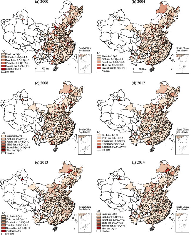
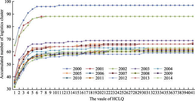
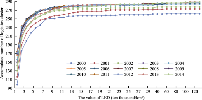
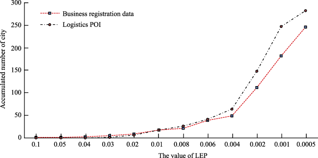
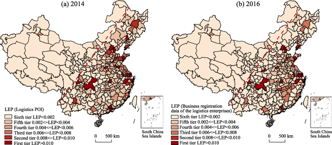
Research Articles

Quantitative measurement and development evaluation of logistics clusters in China

  • LIU Sijing , 1 ,
  • LI Guoqi , 2, * ,
  • JIN Fengjun 2
Expand
  • 1. School of Transportation & Logistics, Southwest Jiaotong University, National United Engineering Laboratory of Integrated and Intelligent Transportation, Chengdu 610031, China;
  • 2. Institute of Geographic Sciences and Natural Resources Research, CAS, Beijing 100101, China
Corresponding author:Li Guoqi (1984-), PhD and Associate Professor, E-mail:

Author: Liu Sijing (1984-), PhD, specialized in geography of logistics and spatial analysis. E-mail:

Received date: 2018-04-26

  Accepted date: 2018-06-30

  Online published: 2018-12-20

Supported by

National Natural Science Foundation of China, No.71603219, No.41501123

Copyright

Journal of Geographical Sciences, All Rights Reserved

Abstract

The logistics clusters are the result of concentration, scale and specialization of logistics activities, and their quantitative measurement and development evaluation provide an important foundation for improving the land use efficiency and achieving economies of scale. Taking 289 cities at prefecture-level and above as research objects, this paper collected macro-statistical data of transport, postal and warehousing industry during 2000-2014, business registration data of more than 290 thousand logistics enterprises, and 170 thousand logistics points of interest (POI). With the integration of multi-index and multi-source data, the evolution process and spatial pattern of logistics clusters in China were explored with the methods of Location Quotient (LQ), Horizontal Cluster Location Quotient (HCLQ), Logistics Employment Density (LED) and modified Logistics Establishments’ Participation (LEP). The development levels, types and modes of different logistics clusters were quantified. Several important findings are derived from the study. (1) The logistics clusters are mainly located on the east side of the Hu Huanyong Line, and the accumulative pattern evolves from group to block structure, featuring wide coverage and high concentration. The evolution of logistics clusters has two stages of rapid convergence and stable change, resulting in gradual increase in the development level and efficiency of logistics clusters and in emergence of spillover effect. (2) 21 mature logistics clusters are distributed in the core and sub-cities of the main metropolitan areas of 16 provincial-level administrative divisions, conforming to the government logistics and transport planning. 43 emerging logistics clusters are distributed in 21 provincial administrative divisions, and different types of cities have huge disparities which highlight the differentiation of the market behaviors and government planning among them. (3) The logistics clusters present differentiated development modes with the change of scales. In urban agglomerations scale, the nested “center-periphery” structures with “main nucleus-secondary cores-general nodes” are clarified. The polar nuclear development, networked and balanced development, single core and multipoint, multi-core multipoint hub-spoke development patterns are formed in different provincial administrative divisions.

Cite this article

LIU Sijing , LI Guoqi , JIN Fengjun . Quantitative measurement and development evaluation of logistics clusters in China[J]. Journal of Geographical Sciences, 2018 , 28(12) : 1825 -1844 . DOI: 10.1007/s11442-018-1566-x

1 Introduction

Logistics cluster is defined as the geographical concentration of different types of collaborative and competitive logistic enterprises. It can help enhance the competence of cities in participating in global division (Sheffi, 2012; Rivera et al., 2014) and play an important role in optimizing the allocation of logistic resources and promoting economic structuring and upgrading (Baranowski et al., 2015; Hai et al., 2016; Rodrigue et al., 2017). Logistic cluster integrates many manufacture-related service industries and multiple types of logistic facilities, which have dual attributes of service industrial cluster and facilities cluster. As a newly emerged concept, the key components, boundaries, corridors and operation mechanism of logistics cluster are slowly springing up (Sheffi, 2012; Rivera et al., 2014; Li et al., 2017). Current research results on the motivation, location of service industrial cluster and quantification, optimization, simulation of traffic hubs and nodes could not provide a comprehensive and accurate explanation to the questions such as the formation, development and evolution of logistics cluster (Qiu et al., 2013; Wang, 2014; Birtchnell et al., 2015; He, 2017; Li, 2017).
Since Sheffi (2012) proposed the concept of logistics cluster, the focus of international researches has shifted from the understanding of its content and characteristics to its quantification and policy response. The major results concentrate in two areas. One is to treat cities and even larger space scope as logistics cluster and identify it with the method of per capita output value of logistics and logistics value per unit of GDP, the objects of researches are mainly located in America, Britain, Australia, Spain and Japan (Cidell, 2010; Prause, 2014; Chung, 2016; Ducret et al., 2016; Rolkoa et al., 2017). Another is to regard well developed zone of logistics concentration, i.e., logistics bases, logistics parks and logistics industrial belts, as logistics clusters. Structure Equation Model and spatial measurement methods are adopted to explain the operation mechanism of specific logistics clusters (Chhetri et al., 2014; Rivera et al., 2016; Hylton et al., 2017). For example, Kumar et al. (2017) adopted space regression model and Spatial Autoregressive Model with Autoregressive Disturbances (SARAR) model to analyze the economic, traffic and geological data of 2008-2012 in U.S. regions and verified that logistics clusters are more concentrated in urban agglomeration and transport infrastructures have a positive influence on the transport and logistics cluster employment. In China, Wen et al. (2005) was among the first to study logistics cluster, and later researches of other scholars were devoted to service industry clusters, transportation facilities and spatial organization of logistics enterprises etc., focusing on the identification of characteristics and connotation of logistics clusters, analysis of interaction mechanism between logistics cluster and regional economic development. However, Chinese empirical researches in this regard are comparatively weak (Wang, 2010; Ding et al., 2011; Zhao et al., 2012; Li, 2013; Hai et al., 2016; Pan, 2016; Cui et al., 2017). Some differences are noted between Chinese and international researches on logistics clusters. Firstly, in researches based on administrative division, developed countries have mostly established more detailed industrial classification code and industrial development database so that the results from extraction of logistics cluster data and those of empirical studies can be compared and validated (Rivera et al., 2016), while China’s logistics industry has not been included in the statistical classification system. Instead, statistics of transportation, warehousing and postal services are used for most of the quantitative analysis in most of the existing researches, and data in the Yellow Pages are also analyzed in some others. Thus, comparative analysis in China can hardly be performed. Secondly, in the study on the formation mechanism of logistics clusters in a particular region, questionnaires are used to obtain data in most international researches. However, the data collection standards adopted by different scholars are inconsistent and data comparison and verification are thus more difficult. Micro-scale research on logistics cluster is still in its infancy (Qiu et al., 2013; Hai et al., 2016). In general, the lack of research data in the logistics industry, as well as that of researches on the operation mechanism and quantitative screening of logistics clusters have restricted the deepening of theoretical and empirical researches on logistics clusters.
China’s logistics cluster has gradually grown and developed with the transformation and upgrading of logistics industry, cost reduction and efficiency enhancement and the rapid development of new economy. As a result, the existing logistics spatial patterns are restructured, logistics organization mode changed, and many new modes and formats established. Thus, it is urgent to further the understanding of the basics of its formation, development and evolution so as to promote the intensified development of logistics space. This paper took 289 cities at prefecture-level and above as research objects, and explored the evolution process and spatial pattern of logistics clusters in China based on the logistics POI collected from the Internet-based online map, business registration data of logistics enterprises, and current macro-statistical data of transport, postal and warehousing industry. The existing problems such as homogenized data source, limited sample size, and difficulty in integration, have been solved and multi-index and multi-source data can be compared and verified to improve the accuracy and validity of the quantitative research on logistics cluster, which can benefit the decision-making for logistics space optimization and precision control.

2 Sources of data and research methods

2.1 Sources of data and research objects

Logistics cluster data of the United States, the most typical in international researches, is acquired through the statistics of transport, courier, post, distribution, handling and other 27 sectors in the North American Industrial Classification System (NAICS six-digit code), covering the main areas of logistics services (Rivera et al., 2014; Kumar et al., 2017). In this research, the data is collected from the following three areas to quantitatively screen and identify the formation, development and evolution of the logistics cluster at prefecture-level and above, and to evaluate the development levels of different clusters.
(1) Macro-statistical data of cities at prefecture-level and above in China. Collected in December 2016, the data covers 289 cities at prefecture-level and above during 2000-2014 (excluding Hong Kong, Macao and Taiwan). The key indicators include employment population in transport, postal and warehousing industry, employment population (all industries), GDP and areas of land on the scale of cities at prefecture-level and above, derived from China City Statistical Yearbook. Such type of data, being the most widely used, is complete, accessible and covers a long lifespan, and can represent the overall development level of logistics industry.
(2) Business registration data of China’s logistics enterprises. Collected from the State Administration for Industry and Commerce in December 2016 and with a data volume of 294,026 entries, the major items include enterprise name, registered capital and cities of registration. The data can reveal the main level and capability of logistics market in multi-scale and multi-type analysis. Compared with the enterprises in the Yellow Pages, the data is reliable and authoritative with its large sample size and fast update speed.
(3) Logistics POI of cities at prefecture-level and above in China. With keywords such as “logistics”, “transport”, “express service”, “postal service” etc., logistics POI was collected based on Baidu Online Maps Platform in February 2015 (excluding Hong Kong, Macao and Taiwan). In the acquisition process, duplicate checking was automatically performed, and the data irrelevant to logistics enterprises removed. A total of 170,351 entries were obtained, and the main items include the logistics POI names, latitude and longitude coordinates, etc. Maps Online, the source of acquisition, has wide coverage of different types of data and numerous terminal facilities, which has in recent years attracted widespread attention in the academic circles both at home and abroad. It has become a new data source for logistics researches and serves as an important basis for the indication of microscopic vitality of the logistics market (Li et al., 2017; Xu et al., 2016; Qin et al., 2017).
The data from the above areas are obtained both on and off the Internet. With multi-scale, the data can be easily integrated and used for cross verification and for future follow-up and comparative study. The macro-statistical data in 2000, 2004, 2008 and 2012 and the business registration one and logistics POI in 2014 are selected in this study. Both those two types are interrelated and the focus was put on the changes in 2013 and 2014. In view of historical development in the years of 2000, 2004, 2008 and 2012 and their interconnectivity in economic census, the years of 2000, 2004, 2008, 2012, 2013 and 2014 are determined as the typical ones in this research with consideration given to the time differences in data collection from diversified sources. To avoid insufficiency in data of the typical years, temporal and spatial evolution of consecutive years is taken into account in the actual analysis process.

2.2 Research methods

On account of limitations in accuracy of logistics statistics and data on logistics enterprises, the two indexes of Location Quotient (LQ) and Horizontal Cluster Location Quotient (HCLQ) are adopted in the quantitative screening of logistics clusters in international studies, as both are often used in combination to fully reflect the relative and absolute size of impact of employment on geographical concentration. Location Gini Coefficient (LGC), Herfindahl-Hirschman Index (HHI), and Ellison-Glaeser Geographic Concentration Index (EGGCI) are also commonly used in industrial concentration assessment, but the first two indicators on a national scale while the last one not widely used for reason of incompleteness of the data indicators. In order to facilitate comparative studies both at home and abroad and to make up for the inadequate reflection in present researches of the impact of firm size and geographical area on the geographical concentration of industries, Logistics Employment Density (LED) and modified Logistics Establishments’ Participation (LEP) proposed by MIT Center for Transportation and Logistics are also used in addition to LQ and HCLQ for the quantitative screening of logistics clusters.
2.2.1 Location Quotient (LQ)
LQ is the ratio of employment share of the industry of interest in the area of interest and the employment share of that industry in a reference area (Rivera et al., 2014). Because of data insufficiency, LQ has been widely used in economic geography and regional economics. Location quotient can be used to test the level of logistics specialization at different scales through employment or output value to reflect the relative specialization of industries in a certain region. The formula is as follows:
$LQ={\left( {{{E}_{ig}}}/{{{E}_{in}}}\; \right)}/{\left( {{{E}_{tg}}}/{{{E}_{tn}}}\; \right)}\;$ (1)
where Eig is employment of the industry i in region g; Ein is employment of the industry i in country n; Etg is total employment in region g; and Etn is total employment in country n. In general, industry i is considered to have a competitive advantage across the country when LQ>1. In the study of logistics cluster, the employment population of transport, postal and warehousing industry is used to replace logistics employment population. The indicator of LQ>1 is also used as an important one of logistics industry cluster in international researches.
2.2.2 Horizontal Cluster Location Quotient (HCLQ)
HCLQ is mainly used to make up for the defects of absence of the absolute size of industries in the region in LQ. The difference between the actual employment and the anticipated employment in the industry reflects the impact of the absolute size of employment on geographical concentration. The formula is as follows:
$HCLQ={{E}_{ig}}-{{\overset{\scriptscriptstyle\frown}{E}}_{ig}}$ (2)
where ${{\overset{\scriptscriptstyle\frown}{E}}_{ig}}$ is estimated employment of industry i in region g when LQ=1. HCLQ>0 indicates that the level of the employment concentration in the logistics industry of region g is higher than that of the entire country. HCLQ helps to identify the location and magnitude of the concentration of logistics activities. On this basis, LED is introduced to eliminate the impact of geographical area on the concentration of logistics activities. LED represents logistics employment population per unit area (ten thousand/km2). The formula is as follows:
$LED={{{E}_{ig}}}/{{{A}_{g}}}\;$ (3)
where Ag is land area of region g.
2.2.3 Logistics Establishments’ Participation (LEP)
It is mainly used to eliminate the results in concentration level of undifferentiated activities caused by internal or external economies of scale with the existing measure indicators of employment. However, the model fails to effectively distinguish the difference in the level of geographical concentration under the impact of the different sizes of logistics organizations. On the basis of data availability, the LEP calculation method is improved by using the registered capital of logistics enterprises as the criteria for determining their sizes, details of which are as follows:
$LEP={\sum\limits_{j}{E{{S}_{jg}}}}/{\sum\limits_{j}{E{{S}_{jn}}}}\;$ (4)
where ESjg signifies the number of type j logistics enterprises in region g; ESjn is the number of logistics enterprises with the scale of j in the country. According to the registered capitals of enterprises, the enterprises could be divided into four types: the small and micro-sized enterprises with the registered capitals of below 0.1 million yuan, the small enterprises with the registered capitals between 0.1 million and 5 million yuan, the medium enterprises with the registered capitals between 5 million and 10 million yuan, and the large enterprises with the registered capitals above 10 million yuan. The weights for each type of enterprises are set to be 1 for the small and micro-sized enterprises, 2 for the small enterprises, 3 for the medium enterprises, and 4 for the large enterprises. As the sizes of enterprises cannot be effectively distinguished for logistics POI, the original LEP formula will be used. The determination of the validated indicator is key to the verification of the validity of the logistics cluster.

3 Research results

3.1 Logistics clusters identification based on LQ

From the perspective of spatial pattern, the logistics clusters represented by LQ values are mainly located on the east side of Hu Huanyong Line, with the provincial capital cities of Urumqi, Hohhot, Xining, Lanzhou and Lhasa on the west, and the regional nodal cities such as Longnan, Hulunbeir and Ulanqab lie close to the line (Figure 1). In terms of the regions and shapes of logistics cluster, the Yangtze River Delta urban agglomeration, Beijing-Tianjin-Hebei urban agglomeration, the Middle Reaches of the Yangtze River, the Harbin-Changchun urban agglomeration, the Central Plains urban agglomeration and the Hohhot-Baotou-Yinchuan-Yulin urban agglomeration are all areas of relative concentration. However, the core cities of urban agglomerations are located at the high level of the cluster, consistent with the basic rules of logistics cluster layout in other countries (Kumar et al., 2017). The pattern of the clusters spreading from the core cities to the periphery is changed into the block type with the development of single core city as the nucleus. For example, the number of cities in the Beijing-Tianjin-Hebei urban agglomeration in 2000 decreased from 8 to 5 in 2014; the number of cities in the Yangtze River Delta decreased from 18 in 2000 to 6 in 2014, which is not only attributable to the increasing maturity and efficiency in the development of the logistics cluster but also the internal reallocation of resources within the logistics cluster and the result of reorganization of space.
Figure 1 Spatial pattern of logistics clusters of cities at prefecture-level and above in typical years by LQ
Judging from the changes in number and structure in its evolution process, logistics clusters have experienced a stage of rapid decline and another of relative stability, indicating that centralization and scale is its development trend and the cluster efficiency has been improved.
In terms of the number and structure of cities with different location quotients (Figure 2), the number of LQ>1 logistics clusters dropped from 97 (37.0% of the total) in 2000 to 63 (22.1% of the total) in 2004, and then the number fluctuated within the range of 59-67; The number of LQ>2 logistics clusters dropped from 13 (4.6% of the total) in 2000 to 5 (1.8% of the total) in 2004 and then rose rapidly. From 2006 to 2010, the number of logistics clusters stabilized at 9-11 with slight fluctuations within the range, while during 2011-2013 the number varied within the range of 6-8. The change in the number of LQ>3 clusters was closely related to the former two. They emerged after the numbers of LQ>1 and LQ>2 clusters dropped rapidly and remained stable, and the number of LQ>3 clusters was 1 and remained stable during 2005-2010. Thereafter, the LQ>3 clusters disappeared temporarily and then the number rose from 1 to 2 with the small range fluctuations of the numbers of the former two groups of clusters from 2011 to 2012, demonstrating the gradual structure optimization of different levels of logistics clusters and the development trend of centralization and scale. The third national economic census data further confirmed the improvement of efficiency in the logistics industry brought by the large-scale logistics clusters. By the end of 2013, the employment population of the enterprises in transport, postal and warehousing industry had reached 12.47 million, the unit number of employees per enterprise reached nearly 50, and the unit assets per enterprise was 75 million yuan. Compared with the second economic census in 2008, the unit number of employees per enterprise dropped by 19 and the unit assets per enterprise increased by 24 million yuan. This shows that the level of mechanization and automation was promoted and the per capita output increased in the logistics industry with the growth in scale.
Figure 2 Evolution process of logistics clusters of cities at prefecture-level and above during 2000-2014
With regards to the pattern of changes for the core cities in the evolution process, the total number of LQ>2 cities is 27, including the two municipalities of Shanghai and Beijing, 11 provincial capitals (including Dalian) and 14 prefecture-level cities. In consideration of the volatility and randomness of the sample data, the anomalous data that occurred only once or twice before 2006 are removed and the logistics clusters are divided into the following three categories: (1) Cities with higher cluster level and stability: Fangchenggang and Qinhuangdao (14 times), Urumqi (10 times), Datong (9 times), Qiqihar (8 times), Shenyang (7 times), Guangzhou and Nanchang (6 times), Taiyuan and Shanghai (5 times), Xining, Zhoushan and Xuzhou (3 times). Most of these cities are ports, important railway hubs and resource-based cities. They have the advantages of favorable traffic and logistics locations and have large industrial and transit logistics demands. (2) Cities with a high level of clustering but declining continuously. Liuzhou and Kunming (5 times), Jinzhou (4 times) and Hohhot (3 times). At these cities, demands for transshipment and industrial logistics were reduced for the weakening of their positions as communication hubs and their industrial restructuring. (3) Yingkou (2 times), the emerging cluster city since 2012. As an important city at the sea passage in Northeast Asia, Yingkou Port boasted in 2012 a handling capacity of 301.07 million tons which kept growing strongly and surpassed that of Dalian Port. It ranked No. 9 in the coastal ports of the country and gradually developed into a strategically important traffic node of the “Belt and Road” and an important hub of the international sea-rail transport corridor (Han et al., 2017), indicating the emergency of new logistics clusters and the change of the existing spatial pattern of logistics as a result of benefits from major national strategies.

3.2 Logistics clusters identification based on HCLQ and LED

Compared with LQ, the hierarchical structure of logistics clusters signified by HCLQ value is more distinct (Figure 3). The feature of blocks clustering around the core cities are more prominent, indicating that the absolute advantage in employment over the comparative one better reflects the geographical difference of logistics development. Since 2012, the spatial pattern of logistics cluster has moved toward the core cities of Northwest and Southwest China close to Hu Huanyong Line. The clusters in the southeast coastal areas have been relatively stable and those in the northeast have declined. This is closely linked with the speedy entry of foreign-funded logistics enterprises in the northwestern and southwestern regions under “the Belt and Road Initiative” and the Yangtze River Economic Belt and the remarkable achievements in the construction of international logistics channels (Zong et al., 2017). In Northeast China, the demands for logistics of resource-based industries decrease and the logistics market lack innovation vitality in the process of industrial restructuring. As a result, the logistics agglomeration ability was impaired. The logistics cluster in eastern coastal areas showed some spillover effects, while the trans-regional southwestern and northwestern regions showed more significant clustering effects. However, most of the neighboring central regions are located the economic radiation area of the logistics clusters in the coastal areas, and their agglomeration ability is not significant (Hu et al., 2015; Tang et al., 2017).
Figure 3 Spatial pattern of logistics clusters of cities at prefecture-level and above in typical years by HCLQ
Compared with LQ and HCLQ, the spatial pattern of logistics cluster characterized by LED is more stable (Figure 4), manifesting the feature of group-dominated clustering. The higher level of clusters in the southeast coastal region and Beijing-Tianjin-Hebei urban agglomeration demonstrates significant regional difference represented by those demarcated by Hu Huanyong Line, and the differences of spatial patterns in the former two index values are mainly reflected in the modes of clustering. Typical first-tier cities such as Beijing, Shanghai, Guangzhou and Shenzhen have become the major clustering areas for large-scale logistics enterprises’ headquarters and large-scale e-commerce central warehouses and the main areas attracting logistics employment, which has led to an increase in the density of logistics employment (Deng, 2014). According to the survey by China Federation of Logistics & Purchasing (CFLP), the average price of logistics land in 2014 was 800 thousand-1 million yuan/mu in the first-tier cities, 400-500 thousand yuan/mu in the second-tier cities and 100-150 thousand yuan/mu in the third-tier cities. Secondly, in order to optimize the utilization of logistics land and improve logistics efficiency, most mega-cities have promulgated control standards for the utilization of logistics and warehousing land (Li et al., 2015), which has accelerated the concentration of logistics enterprises and the improvement of logistics efficiency, and promoted the logistics sub-urbanization and the development of logistics clusters in the surrounding satellite cities of metropolitans. It is consistent with the fact that the ratio of logistics cost and GDP of the mega-cities in the eastern part of China generally falls below the national average, further confirming the increase in efficiency and decrease in logistics cost have promoted the intensive and efficient development of the logistics clusters and improved the employment density of logistics. In some cities with relative less population, poorer resources and lower environment bearing capacity, especially some cities on the west side of Hu Huanyong Line with low urbanization level and low population density, the construction of logistics and transportation infrastructure lags behind, and the LED cluster level is relatively low, highlighting the importance of intensive and efficient development of logistics clusters.
Figure 4 Spatial pattern of logistics clusters of cities at prefecture-level and above in typical years by LED
To make up for the lack of uniform standards in the identification of logistics clusters with HCLQ and LED, it is helpful to observe the changes in the cumulative numbers of logistics clusters under different indicator values so that the evolution characteristics of logistics clusters can be revealed accurately (Figures 5 and 6). In terms of the magnitude of change, there is a clear “rapid growth” area. Among them, the rapid growth ranges of HCLQ values and LED values are between 1 and 4, indicating that the more concentrated the logistics clusters are, the more stable they are, and a common cumulative quantitative distribution is noted. In respect of time changes, the starting points for the concentration of logistics clusters differ in the first 4 years and latter 11 years, directly related to the increase in the number of cities at prefecture level and above from 262 to 289, which also shows that the cities at prefecture level and above included lately are mostly located in a higher level of concentration areas. Secondly, with regards to the range of change, without the influence of the first 4 years, the variation ranges of HCLQ and LED values remain at 17-25 and 79-99 (ten thousand/km2), respectively. Considering the ratio of 1:4 for the total numbers of HCLQ and LED, they also show a similar pattern. In summary, all the indicators of HCLQ and LED display that logistics clusters are constantly evolving and the level of concentration is continuously increasing, which is basically consistent with the conclusion made with LQ.
Figure 5 Cumulative curve of number of logistics clusters by the value of HCLQ during 2000-2014
Figure 6 Cumulative curve of number of logistics clusters by the value of LED during 2000-2014
In terms of the patterns of change for the core cluster cities in the evolution process, the evolution of logistics clusters remains generally stable with slight changes, and the level of cities is proportional to the stability. Most of the HCLQ > 4 cities are municipalities, provincial capitals and sub-provincial level cities (accounting for 94.1% of the total), while among the LED >10 cities, prefecture-level cities account for 43.4% of the total. The results are as follows, (1) The cities with high clustering level and stability as represented by the HCLQ values such as Guangzhou (15 times), Shanghai and Beijing (12 times) are designated as global central cities in the new national urban system planning. They are highly influential and have high level of economic development and strong logistics demand. The similar type of cities as represented by LED values such as Shanghai, Beijing, Guangzhou, Shenzhen, Nanjing and Xiamen (15 times), all are national central cities. They have large number of logistic employment population per unit area and prominent logistics advantages. The cities identified with both HCLQ and LED values are highly identical. (2) However, substantial differences are noted in cities with high clustering level and relative stability as identified with HCLQ and LED values. As with HCLQ, the cities are Shenyang (13 times), Harbin and Wuhan (8 times), Nanjing and Kunming (7 times), and Shenzhen, Xi’an, Nanchang and Urumqi (4 times). As for LED, the cities are Tianjin and Wuhan (12 times), Taiyuan and Xi’an (6 times), and the results derived from identification with the two indexes are generally consistent. Among them: Shenyang has the highest number of times, but ranked the last in 2013 and is not listed in 2014, indicating its level of clustering is on the decline. (3) Among the emerging logistics cities identified with both HCLQ and LED values, Chengdu is included consecutively in 2013 and 2014. As the core city and the national central city of Chengdu-Chongqing Economic Zone, Chengdu has made logistics planning quite early and took the lead by setting up a government department of logistics and port. Benefiting from the country’s “Belt and Road Initiative”, it gradually becomes an important logistics hub for the China-Europe Transport Corridor. Cities identified with LED such as Zhuhai (4 times), Zhoushan (3 times) and Dongguan (2 times) are all port cities, Zhoushan and Zhuhai have national-level new areas. Dongguan is also an important transportation hub and trade port in Guangdong. The difference between the two categories of cities identified with HCLQ and LED is significant, but they all reflect the dynamic development of logistics clusters.

3.3 Logistics clusters identification based on LEP

3.3.1 The value of LEP and the initial identification of the development level of logistics clusters
According to the identification methods of logistics clusters with LEP value for the cities and counties in the United States and those for the domestic logistics hubs, 21 national logistics hub cities and 17 regional ones designated in Logistics Industry Adjustment and Revitalization Plan promulgated in 2009 by the State Council are singled out as the objects of study, despite of the absence of explicit criteria for the identification of logistics clusters in China. For reference and comparison, the cities with national level logistics park as designated in National Logistics Park Development Plan in 2012 by the State Council and the national integrated traffic and transportation hub cities as listed in the 12th Five-Year Plan for Comprehensive Transportation System by the State Council are also selected for study. Based on the business registration data of the logistics enterprises in 2016 and the logistics POI in 2014, the accumulated changes in the number of cities under different LEP values are calculated (Figure 7).
Figure 7 Cumulative curve of number of cities by the different values of LEP
In light of the 80/20 principle, 80% of the national logistics hub cities meet the test values and are regarded as a well-developed mature logistics clusters. 80% of the regional logistics hub cities meet the test values and are regarded as emerging logistics clusters with potential for development. The results show that the LEP values based on business registration data and POI for the two groups of cities can be verified and validated in the identification of logistics clusters, which are stable, reliable and adaptable to the policies issued. The test values of the well-developed mature logistics clusters for the two LEP values derived from registration data and POI are 0.008 and 0.007 respectively, with a difference of 0.001, which is 8 times and 7 times of the test values of the mature city and county logistics clusters in 2008 in the United States. The number of counties in the United States is 10.6 times of that of cities at prefecture-level and above in China, and differences of 6 and 8 years are noted respectively for the identification with the two LEP values. This shows that the development status of both China and US’s logistics clusters are relatively similar, and also indicates that the business registration data and the Internet-based online POI can be verified and validated with each other, demonstrating high reliability and accuracy in the scale-space analysis of cities at prefecture-level and above (Xu et al., 2016; Li et al., 2017). Second, POI was collected at an earlier time and it is difficult to determine the specific sizes; business registration data is updated and weighted according to the registered capital, and the results are more consistent with the actual situation and the results of logistics cluster identification in the United States. The proportions of the two LEQ values for the well-developed mature logistics cluster cities that have passed the test and meet the conditions are 11.0% and 7.2% respectively, the levels of concentration and efficiency are obvious in the latter, which conforms to the conclusion made with LQ, HCLQ and LED that the ability and efficiency of logistics cluster improve continuously with the pass of time. With regards to policy adaptability, more than 80% of the well-developed mature logistics cluster cities are cities with national logistics hubs, national logistics parks and national integrated transportation hubs, which manifests that government guidance is an important condition in the formation of logistics clusters. Among the emerging logistics clusters with potential for development, the two test results are consistent, both of which are 0.002, but the proportion of cities that meet at least two requirements of government planning has dropped to below 20%, indicating that logistics cluster should be identified with LQ, HCLQ and LED indicators in addition to LEP.
3.3.2 LEP-based spatial pattern and distribution characteristics of logistics cluster
Based on the analysis of LEP value and the level of development of logistics cluster, the spatial pattern of logistics cluster identified with POI in 2014 and business registration data of logistics enterprises in 2016 is analyzed (Figure 8). The results show that:
Well-developed mature logistics clusters are mainly located in the core cities and secondary cities of urban agglomerations, showing the distribution characteristics of “domination of traditional core cities with emergence of new cluster cities”. With accumulation of abundant logistics resources, existing municipalities and sub-provincial cities take the lead and their advantages are obvious. Cities such as Suzhou, Wuxi, Xuzhou, Foshan, Dongguan and others with strong and solid industrial foundation and the regional central cities located in developed provinces of Guangdong, Jiangsu, Zhejiang and others stand out, and their level of cluster concentration significantly increases, manifesting network-based and coordinated development of logistics level and the high degree of integration of logistics industry. Other well-developed mature logistics cluster cities such as Lianyungang, Jinhua, Weifang, and Baoding are results of the combined effects of their locations, policies and demands. For example, benefiting from the “Belt and Road Initiative”, Lianyungang, Nanjing, Suzhou and Xuzhou are all established as the four major integrated logistics hubs in Jiangsu Province. Thanks to the unique position in Yiwu’s commerce and trade and the construction of international land-port, the vitality of logistics market in Jinhua keep improving. Moreover, Zibo and Jinan, core-node cities of central Shandong logistics region, is designated by Shandong Province as a key provincial logistics node city.
Figure 8 Spatial pattern of logistics clusters of cities at prefecture-level and above in typical years by LEP
The layouts of emerging logistics clusters with potential for development are well balanced, but the differences among the cities are significant. Emerging logistics clusters are widely distributed in 31 administrative regions of China’s mainland, reflecting the fact that China’s logistics clusters are characterized by wide coverage and high concentration. However, influenced by many factors such as the level of logistics market and that of urbanization, levels of emerging clusters in some prefecture-level cities are higher than those of the provincial capital cities. For example, Yichun in Jiangxi Province, cities of Ganzhou and Yancheng are not included in the key areas of government logistics planning, but their levels of logistics cluster are higher than those of the national logistics node cities designated by the municipal government such as Nanning, Urumqi, Lanzhou and other cities, which is the expression of differentiation between market operation behavior and government planning and also the diversified channels for the formation of the logistics clusters.

3.4 Multi-index superposition analysis and evaluation of development level of logistics cluster

3.4.1 Superposition analysis
Based on the availability and comparability of data, superposition analysis are performed on the LQ, HCLQ and LED based on the logistic employment population in 2014 and the results of logistics cluster identified with LEP on the basis of the number of logistics enterprises in 2014 and 2016 (Figure 9), the results show:
The degree of coordination of multi-index superposition based on employment population is weak and decreases with the decline of the level of logistics cluster and the increase in the number of cities. For example, as identified with LQ values, cluster cities with significant advantages are Xiangtan, Urumqi, Taiyuan, Qiqihar, Fangcheng, Yingkou, Qinhuangdao and Guangzhou. Among them, there are 3 provincial capital cities, 3 port cities, and 2 prefecture-level cities with strong industrial foundation and large population, reflecting the transportation and market orientation of the development of logistics clusters. However, the coordination with the national relevant planning is weak. The two indicators of HCLQ and LED, though adaptable in cross-strata at the same level, have significant differences among cities identified with LQ, and similar geographical locations, industries and demographic features, indicating that these cities have the necessary employment foundation for the logistics clusters and the limitations of the logistics cluster identification based on the employment population as well.
Figure 9 Results of superposition of logistics employment population and logistics enterprises
The degree of coordination of superposition of multi-sourced data based on the number of logistic establishments is comparatively high, but decreases to some extent with the decline of the levels and rise in the number of the cities. For example, the four municipalities, i.e., Beijing, Shanghai, Tianjin and Chongqing, as well as sub-provincial level cities such as Guangzhou, Shenzhen, Chengdu, Xi’an, Wuhan, Nanjing, Ningbo, Zhengzhou and Qingdao, have well-developed mature logistics clusters, which conforms to the results of identification with LEP based on multi-sources. This indicates that metropolitan areas with good traffic conditions, complete logistics-related functions, strong market demands and commensurate infrastructures are the main carriers for the development of the logistics cluster. Secondly, the results of logistics cluster division based on LEP conform to the ones of identification of traffic hub cities based on the accessibility and traffic superiority (Cao et al., 2005; Jin et al., 2008; Wu et al., 2011), and are consistent with the government-planned national logistics node cities and cities with proposed logistics parks, which has been used in the identification of logistic clusters in the United States.
3.4.2 Results of comprehensive classification of development level of logistics cluster
With the superposition analysis of multiple indicators, the classification of the levels of development of logistics cluster determined with the LEP values, results of identification with LQ, HCLQ and LED, the methods of superposition on same level and cross-strata one on the same level are combined to further divide the well-developed and mature logistics cluster into I, II, and III three subcategories (Table 1), and the results show that:
With regards to the scale of urban agglomeration, the logistics cluster presents a multi-level core-periphery structure, as can be obviously displayed in the urban agglomerations of the Yangtze River Delta and the Pearl River Delta. The former has a multi-level structure with Shanghai as the main nucleus and Nanjing, Ningbo, Hangzhou and Suzhou as the secondary nuclei, Wuxi, Hefei, Changzhou, Jinhua, Zhoushan and Nantong as general nodes, complete with necessary conditions for the development into a global logistics cluster; the latter with Guangzhou, Shenzhen as the main nucleus, Dongguan as the secondary nucleus, and Zhongshan, Zhuhai and Foshan as general nodes. Propelled substantially by the construction of the Guangdong-Hong Kong-Macao Greater Bay Area, the urban agglomeration of the Pearl River Delta is expected to collaborate with Hong Kong in the development of global logistics cluster. Similar structures are also found in the Beijing-Tianjin-Hebei, the Middle Reaches of Yangtze River, the Harbin-Changchun and the Shandong Peninsula Urban Agglomeration. As an important space carrier, the division of labor and space restructuring in the cities have become an important foundation for the development of logistics cluster.
Table 1 Results of comprehensive development evaluation of logistics clusters in China
Category Subcategory Standards Results
Mature logistics cluster I First level cities with one of the indexes for each of the two types satisfied Shanghai, Beijing, Guangzhou, Shenzhen, Chengdu, Xi’an
II First level cities with type two indexes satisfied Tianjin, Chongqing, Wuhan, Nanjing, Zhengzhou, Suzhou, Ningbo, Hangzhou, Qingdao
III Second level cities with LEP or one of the indexes for each of the two types satisfied and up cross-strata Jinan, Kunming, Harbin, Dalian, Xiamen, Dongguan, Shenyang
Emerging logistics
cluster
I Other level first and second level cities Changsha, Urumqi, Taiyuan, Foshan, Xuzhou, Qiqihar, Zhoushan, Haikou, Zhuhai, Lianyungang, Jinhua, Wuxi, Weifang, Baoding, Xiangtan
II Third level cities with one of the indexes for each of the two types or type two indexes satisfied Yingkou, Shijiazhuang, Guiyang, Zhongshan, Hefei, Changchun, Fuzhou, Nanning
III Other third level cities, and fourth and fifth level cities with all indexes of both types satisfied Fangchenggang, Qinhuangdao, Xiaogan, Jiaozuo, Shantou, Yichun, Ganzhou, Shangrao, Nanchang, Yantai, Changzhou, Quanzhou, Taizhou, Nantong, Yancheng, Tangshan, Hohhot, Fuyang, Bengbu, Liaocheng

Note: First type of indexes includes the ones of LQ, HCLQ and LED; Second type of indexes includes LEP (business registration data and logistics POI).

As for the scale of provincial level, the logistics cluster covers 28 provincial administrative divisions in China’s mainland except Xinjiang, Qinghai and Ningxia, presenting four development models. (1) The first model is the polar nuclear development one, which means that only one provincial administrative division at the provincial level is selected as the logistics cluster. For example, Chengdu of Sichuan Province and Xi’an of Shaanxi Province, the two provincial capital cities, have accumulated excessive logistics resources and formed a single core structure, and rise to be ranked among the subcategory I of mature logistics cluster in first-tier cities such as Beijing, Shanghai, Guangzhou and Shenzhen. (2) The second model, the balanced network development one, has several cities selected as emerging logistics clusters in one provincial administrative division. For example, the four cities i.e., Baoding, Hebei (Subcategory I), Shijiazhuang (Subcategory II), Tangshan and Qinhuangdao (Subcategory III) are among the emerging logistics clusters, and the cluster level of Baoding, the core of the Xiongan New Area, is higher than that of Hebei’s provincial capital Shijiazhuang. Similar cases arise in Jiangxi and Anhui provinces. (3) The third model is a single-core multi-point and hub-spoke development one, which means one city is identified as the mature logistics cluster and multiple cities as emerging logistics cluster. For example, Fujian Province has a structure with Xiamen (II) as the core, Fuzhou (I) and Quanzhou (III) as the secondary nodes while Henan, Hubei and Heilongjiang are all single point single core structures, being the preliminary stage of this model. (4) The fourth mode is a multi-core multi-point and hub-spoke development mode, which means that two cities in a provincial administrative division are identified as mature logistics cluster and several cities as emerging logistics cluster. For example, Shandong Province has a structure with Qingdao (II) and Jinan (III) as the core and Weifang (I), Yantai and Liaocheng (III) as the secondary nodes. This model is similar to the multi-level core-periphery structure of urban agglomerations and is mainly located in the developed coastal areas such as Zhejiang, Jiangsu and Guangdong provinces.

4 Conclusions and discussion

The formation, development and maturity of logistics clusters are the results of the continuous expansion of the logistics market, the continuous improvement of the logistics infrastructure and network system, the continuous growth of the logistics market, and the active guidance and planning of the government for logistics. With the use of logistics employment population, business registration data and logistics POI for China’s logistics cluster since 2000 to identify the spatial pattern, evolution and development, the study reveals that:
(1) Most logistics clusters concentrate on the east side of Hu Huanyong Line. The core city in the urban agglomeration is the main carrying space of logistics cluster, and the discrepancy between the levels and geographical areas is significant. Especially since 2012, the concentration and scale-up of the logistics cluster are obvious, consistent with the fact that the proportion of China’s logistics costs in GDP dropped from 18% in 2012 to 14.9% in 2016 and the data from the third economic census, which shows that the vigorous reduction of costs in logistics industry in China and increase in efficiency advocated by the Government have created a good external environment for the development of logistics cluster.
(2) In the process of evolution, the logistics clusters, affected by economic development level, traffic locations, construction of logistics parks and passageways, display difference in levels in terms of the urban scale, and the scale of the provincial and urban clusters presents a differentiated development model. In particular, the construction of a rapid transit network with high-speed railways and express highways as the core has changed the traffic accessibility and location conditions in different cities, strengthened the logistics functions and advantages of municipalities and most of the provincial capitals (sub-provincial cities), and improved the quality of logistics services. All these are consistent with the characteristics of logistic clusters identified with LEP indicators, such as “domination of traditional core cities with emergence of new cluster cities”, and also serve as an important driving force for the steady and differentiated distribution of logistics clusters. At the same time, the transfer of hot spots for logistics development under the “Belt and Road Initiative” and the significant increase in the concentration of logistics parks continue to improve service functions and traffic conditions, which plays an important role in the evolution and emergence of logistics clusters. The vitality of the logistics cluster improves, and the structure and quality of the logistics cluster are promoted, facilitating the formation of a differentiated development mode of the logistics cluster.
(3) The evolution and development of logistics clusters are affected by the inherent scale and structure of demand, employment structure, and multiple external factors such as economy, environment, and resource etc., which cannot be fully covered by the existing data sources. In addition, identification of logistics cluster should incorporate factors such as the levels, functions and sizes of cities, functions and sizes of the cities for subdivision of the clusters. This paper has fully considered the cross verification and validation of multi-source data and the comparison between the research results at home and abroad. However, the analysis of business registration data and POI can also be combined with the precise identification with latitude and longitude coordinates. The standardization of multi-source heterogeneous data and the establishment of logistics industry code and other technical issues remain outstanding tasks demand for urgent solutions. The empirical researches on typical mature and emerging logistics clusters will have to be deepened.

The authors have declared that no competing interests exist.

[1]
Baranowski S, Busko E, Shishlo Set al., 2015. Formation mechanism of logistics cluster in Belarus. Agriculture and Agricultural Science Procedia, (7): 12-20.

[2]
Birtchnell T, Savitzky S, Urry J, 2015. Cargomobilities: Moving Materials in a Global Age. New York: Routledge.

DOI

[3]
Cao X S, Xue D S, Yan X P, 2005. A study on the urban accessibility of national trunk highway system in China.Acta Geographica Sinica, 60(6): 903-910. (in Chinese)Based on the "shortest path matrix", the selected characteristic indices-distance, time and speed, this paper analyses the current spatial structure of accessibility in the cities which the national trunk highway system connects, and impacts the speed index made. The cities connected by the national trunk highway system turn out the obvious "core-periphery" model with speed index. The top 50 most accessible cities are concentrated in the middle of eastern China, and the bottom 50 ones are located at the periphery such as northwestern, southwestern and northeastern China. The spatial structure of accessibility measured by time index shows a concentric layer structure with attribute falling gradually from interior to periphery. Moreover, the spatial structure of accessibility in cities connected by the national trunk highway system has obvious boundary effect, which shows wave transformation under different speed conditions. The evidence shows that the change in speed acceleration of the national trunk highway system with an urban accessibility of 60-80 km/h is significantly greater than that of 80-100 km/h. For a given city, averaged 33 cities can be reached within eight hours--a normal working day. Most of the cities with the maximum urban access in eighty hours are concentrated in eastern China, averaged 70 cities. The cities with the minimum urban access in eighty hours are located in the northwestern, southwestern, northeastern and southeastern parts of China. Besides further construction, accelerating the speed of the future national trunk highway system will bring about more impacts on the spatial structure of the cities in China.

[4]
Chhetri P, Butcher T, Corbitt B, 2014. Characterising spatial logistics employment clusters.International Journal of Physical Distribution & Logistics Management, 44(3): 221-241.The purpose of this paper is twofold. First to identify economic activities and broader spatial logistics functions that characterise an urban setting, and second to delineate significant spatial logistics employment clusters to represent the underlying regional geography of the logistics landscape. Using the four-digit Australian and New Zealand Standard Industrial Classification, industries "explicitly" related to logistics were identified and aggregated with respect to employment. A principal component analysis was conducted to capture the functional interdependence of inter-related industries and measures of spatial autocorrelation were also applied to identify spatial logistics employment clusters. The results show that the logistics sector accounts for 3.57 per cent of total employment and that road freight, postal services, and air and space transport are major employers of logistics managers. The research shows significant spatial clustering of logistics employment in the western and southern corridors of Melbourne, associated spatially with manufacturing, service industry and retail hubs in those areas. This research offers empirically informed insights into the composition of spatial logistics employment clusters to regions that lack a means of production that would otherwise support the economy. Inability to measure the size of the logistics sector due to overlaps with other sectors such as manufacturing is a limitation of the data used. The research offers policymakers and practitioners an empirically founded basis on which decisions about future infrastructure investment can be evaluated to support cluster development and achieve economies of agglomeration. The key value of this research is the quantification of spatial logistics employment clusters using spatial autocorrelation measures to empirically identify and spatially contextualize logistics hubs.

DOI

[5]
Chung T W, 2016. A study on logistics cluster competitiveness among Asia main countries using the porter’s diamond model.The Asian Journal of Shipping and Logistics, 32(4): 257-264.Measurement and discussions of logistics cluster competitiveness with a national approach are required to boost agglomeration effects and potentially create logistics efficiency and productivity. This study developed assessment criteria of logistics cluster competitiveness based on Porter's diamond model, calculated the weight of each criterion by the AHP method, and finally evaluated and discussed logistics cluster competitiveness among Asia main countries. The results indicate that there was a large difference in logistics cluster competitiveness among six countries. The logistics cluster competitiveness scores of Singapore (7.93), Japan (7.38), and Hong Kong (7.04) are observably different from those of China (5.40), Korea (5.08), and Malaysia (3.46). Singapore, with the highest competitiveness score, revealed its absolute advantage in logistics cluster indices. These research results intend to provide logistics policy makers with some strategic recommendations, and may serve as a baseline for further logistics cluster studies using Porter's diamond model.

DOI

[6]
Cidell J, 2010. Concentration and decentralization: The new geography of freight distribution in the U.S.Journal of Transport Geography, 18(3): 363-371.This paper examines the suburbanization of warehousing and trucking activity within US metropolitan areas between the 1980s and the present using Gini indices as a measure of concentration. While historical work exists on the relocation of transportation and warehousing activity to suburban locations, there has been little to document the most recent shifts in warehousing and logistics. This research does so via spatial analysis of Economic Census data, finding that while most US metropolitan areas have experienced decentralization in the spatial distribution of freight-related activity, there is also some growth in core counties, indicating that a more complex process is going on than simple suburbanization.

DOI

[7]
Cui Y Y, Song B L, 2017. Logistics agglomeration and its impacts in China.Transportation Research Procedia, 25: 3875-3885.This paper tends to build an econometric model in the perspective of the endogenous growth and new economy geography, and examines how the spill-over effect and scale economies of logistics agglomeration affected the development of Chinese logistics industry based on the panel data of 31 provinces between 2003 and 2012. The results show that the spill-over effect of logistics agglomeration has made a significant contribution to the logistics development among all the provinces while the impact of scale economies upon logistics sectors is restricted within the central and western regions.

DOI

[8]
Deng M, 2014. The relation between transport infrastructure and employment density in Chinese cities: Endogenous relation and spatial spillovers.Economic Management, (1): 163-174. (in Chinese)The relationship between transportation infrastructure and economic growth has been a significant issue concerned by economists,and there are a large mass of literatures about the relation between infrastructure and output,output growth,productivity,inequity,etc.However,researches relating transportation infrastructure to employment,which is one of the main goals of macroeconomic regulatory system,are not fruitful.Existing literatures are mainly about the promotion of infrastructure construction to employment,and very few literatures relate to the promotion of employment to infrastructure construction,which is especially outstanding in the literature about China's infrastructure.So,next comes the question that does employment affect the infrastructure.The research about this question has two significances.The first significance relate to analysis techniques.If employment does have significant effect to infrastructure construct,so infrastructure can not be regarded as an exogenous variable,we should regard it as an endogenous variable.The second significance relate to the economic meaning.If employment does have significant effect to infrastructure construct,so we get a new angle for analyzing the relation between infrastructure and employment.By our theoretical analysis,we believe that there is mutual promotion relationship between infrastructure and employment.Furthermore,infrastructure construction of one region can exert effects to employment intensity of another region.In addition,under the mechanism background of China-style fiscal decentralization,infrastructure investments of different regions in China have a spatial correlation among each other,which induces a spatial correlation of employment intensities among regions.In order to confirm the theoretical hypotheses of this paper,we construct a simultaneous model to analysis the mutual endogenous relation between city transportation infrastructure and employment,on this basis,we introduce spatial lag of dependent variable to the simultaneous model and construct a spatial simultaneous model to estimation the mutual endogenous relation and spatial spillover effect between city transportation infrastructure and employment.The data we use is data of cities at prefecture level and above in China from 1999 to 2010.In order to avoid the endogeneity of dependent variable,we use a three-stage least squares(3SLS) method to estimate the parameters.We find that:(1) Transportation infrastructure of cities has a significant promotion to employment density.In particular,this promotion is greater to the tertiary industry.This finding implicates a strong policy suggestion for China's industrial structure transition and service industry development promotion,as traditionally,people believe transportation infrastructure exerts a greater efforts to the transportation of raw materials and sales for the secondary industry.(2) Employment intensity of the secondary and the tertiary industry promotes the construction of city level transportation infrastructure.This promoting effect could be from an induced demand or by increase of fiscal basis.The elasticity of employment intensity to transportation infrastructure is greater than the latter to the former,(3) Transportation infrastructure of neighbor regions would cease development of the second industry and the tertiary industry in local area.Effect of transportation infrastructure to employment could be underestimated if ignoring such channels.Our findings have two implications:for theories researches,we find that the relationship between city level transportation infrastructure and employment is a mutual instead of a one-way pattern.Transportation infrastructure bears a significant spatial correlation with employment among cities.Estimation results could be biased by ignoring these endogenous relations.As to empirical implication,we find that transportation infrastructure of a city could not only promote its own employment,but more importandy,it could induce the flow of labor into transportation infrastructure-developed cities,which ceases other cities' economic development and employments.Thus we suggest that city governments should make efforts to improve their investment environments to create more job opportunities when accelerating their transportation infrastructure construction.

[9]
Ding J X, Jin F J, Wang C J et al.Wang C J , 2011. Evaluation, optimization and simulation of the spatial layout of transport hubs in China.Acta Geographica Sinica, 66(4): 504-514. (in Chinese)

[10]
Ducret R, Lemarié B, Roset A, 2016. Cluster analysis and spatial modeling for urban freight. Identifying homogeneous urban zones based on urban form and logistics characteristics.Transportation Research Procedia, 12: 301-313.Confronted with the issues of the ‘last mile’, delivery providers have to adapt their logistics organization in cities for more economic and environmental efficiency and in order to meet consumer requirements. A better and systematic use of the providers’ knowledge of the local conditions and of their expertise of cities’ specificities and delivery conditions is one way to reorganize logistics more efficiently and deal with urban logistics challenges. This article develops a preview of a decision-making tool using spatial modeling and clustering which help organize delivery regarding city's characteristics. The framework could help distribution providers achieve relevant and complete territorial diagnosis, prior to the settlement of efficient logistics organizations that suit cities’ characteristics.

DOI

[11]
Hai F, Jin X P, Jia X H, 2016. An analysis on connotation and features of logistics cluster.China Soft Science, (8): 137-148. (in Chinese)In the background of the global economy highlighting the downside risks,the logistics cluster has a unique competitive advantage and significant economic and social benefits. However,the connotation and characteristics of logistics cluster are not clearly known,which seriously affects the healthy development of logistics cluster. This paper begins with the review of the theory of industrial cluster,combined with its own properties of the logistics industry,reveals the connotation of the logistics cluster,clears its unique characteristics,andanalyses logistics cluster'sthe trend of development under the environment of Internet of Things.

[12]
Han Z L, Shang Y Y, Guo J Ket al., 2017. Comprehensive assessment of inland spatial accessibility of the northeast seaports.Advances in Earth Science, 32(5): 502-512. (in Chinese)The spatial accessibility between inland city and seaport plays a very important role in the process of industrial transformation and upgrading and reasonable layout of port and hinterland. Firstly,this paper began with the difference between seaport and inland-city about the property and the traffic flow on traffic network to define the meaning of inland spatial comprehensive accessibility of port. Then,the modified gravity model was used to measure the comprehensive accessibility level of the inland ports in the Northeast China,analyze the different spatial characteristics and explore finally the mechanism of its internal. The results showed that:(1)The accessibility level of the Yingkou Port grew fast and surpassed the Dalian Port at last,the Jinzhou Port followed the Dalian Port,the Dandong Port caught up later,with the Panjin Port and the Huludao Port being slightly behind,but it was contrast with the "n"structure feature measured by the shortest travel time index and the weighted average travel time index. At the same time,the difference among the six ports was more significant in the hinterland of the overall improvement of the traffic network.(2)The inland spatial accessibility of the six major ports is presented along the Harbin Dalian traffic. The level of spatial accessibility in western Liaoning and eastern Mongolia is higher than other areas. There exists a kind of "enclave"phenomenon about the port-inland spatial accessibility of the capital city and the resource type city which have strong comprehensive economic strength.(3)Traffic cost between port and inland resistance promotes the formation of the basic pattern of inland space in the port,and the important traffic lines and the comprehensive "quality"promote the change of this basic pattern.

[13]
He C F, 2017. Geographical Research of Transitional Economy in China. Beijing: Economic Science Press. (in Chinese)

[14]
Hu Y, Li H C, 2015. The estimate of transport hub level and its spatial spillover effects: A spatial panel data study on China’s prefecture-level city.China Industrial Economics, (5): 32-45. (in Chinese)In recent years,with a series of regional development policy releasing,the government proposed the new direction and target for the transport hub,but it has not been resolved that how to measure the transport hub level and what the effect to the economic development of local and surrounding areas.This paper divide the traffic hub level of cities in China and analyzes its spatial distribution,then based on the panel data of Chinese cities in 2003鈥2013,using spatial Durbin model to estimate the influence of the transport hub cities to the local economy and its spatial spillover effects.The results show that the distribution of China's transport hub has obvious spatial imbalance,but is gradually improved.Transport hubs have significant positive influence on the local region and the surrounding region's economic output,effect size sort by the order is national hub,regional hub and district hub.Transportation hubs in eastern region,central region and western region have obvious difference in spatial spillover effect,all kinds of transportation hub have significant positive spillover effects in the eastern region and central region,but the difference between different transport hub in central region is not obvious,and only regional hub city has a significant positive spillover effects in the western region.The government should pay attention to the gradient construction of transport hub to adapt the development of different regions,strengthening the construction of supporting cities groups,promote the formation of industrial cluster,perfecting regional transport infrastructure interconnectivity,advancing the construction of comprehensive transport system.

[15]
Hylton P J, Ross C L, 2017. Agglomeration economies’ influence on logistics clusters’ growth and competitiveness.Regional Studies, (4): 1-12.Agglomeration economies’ influence on logistics clusters’ growth and competitiveness. Regional Studies. This study identifies logistics clusters and explores their effect on establishment and employment growth to extrapolate the presence of competitiveness-enhancing agglomeration economies in clusters. The study uses a US ZIP code-level dataset to enhance past research by increasing spatial precision and statistically controlling for related variables. There is some evidence of disproportionate growth in the number of logistics establishments in clusters due to highly localized agglomeration economies, which appear to degrade quickly over space. However, the results are mixed, calling for research into the mechanisms purported to produce agglomeration economies in logistics clusters.

DOI

[16]
Jin F J, Wang C J, Li X W, 2008. Discrimination method and its application analysis of regional transport superiority.Acta Geographica Sinica, 63(8): 787-798. (in Chinese)

[17]
Kumar I, Zhalnin A, Kim A et al.Kim A , 2017. Transportation and logistics cluster competitive advantages in the U.S. regions: A cross-sectional and spatio-temporal analysis.Research in Transportation Economics, 61: 25-36.This article applies spatial cluster and econometric analyses to study attributes of the transportation and logistics cluster regions across the continental U.S., focusing on jobs, clustering, and dispersal patterns. Two questions are examined: 1) Is transport and logistics specialization a primary feature of large urban metropolitan regions or do rural nonmetropolitan regions (be they micropolitan or noncore) have the capacity to support this type of cluster? 2) Does transport infrastructure explain jobs in the transportation and logistics cluster? The research employs a county level lattice data of transportation and logistics cluster jobs from 2008 to 2012 as well as transport infrastructure variables. The findings reveal that the transportation and logistics clusters are concentrated primarily in metropolitan areas, and to some degree, in nonmetropolitan regions of the U.S. In addition, the transport infrastructure is found to have a positive impact on jobs in the transportation and logistics clusters over the period of the study. Intermodals have the largest effect on jobs, followed by airports, annual average daily traffic on the National Highway Planning Network, railroads, and ports.

DOI

[18]
Li G Q, Jin F J, Chen Y et al.Chen Y , 2017. Location characteristics and differentiation mechanism of logistics nodes and logistics enterprises based on points of interest (POI): A case study of Beijing.Journal of Geographical Sciences, 27(7): 879-896.The logistics nodes and logistics enterprises are the core carriers and organizational subjects of the logistics space,and their location characteristics and differentiation strategies are of key importance to optimizing urban logistics spatial patterns and ensuring reasonable resource allocation.Based on Tencent Online Maps Platform from December 2014,4396 logistics points of interest (POI) were collected in Beijing,China.By the methods of industrial concentration evaluation and kernel density analysis,the spatial distribution pattern of logistics in Beijing are explored,the interaction mechanism among the type difference,supply-demand side factors and location choice behavior are clarified,and the internal mechanism of spatial differentiation under the combined influence of transportation,land rent and assets are revealed.The following conclusions are drawn in the paper.(1) Logistics enterprises and logistics nodes exhibit the characteristic of both co-agglomeration and spatial separation in location,and logistics activities display the spatial pattern of \"marginal area of downtown area,suburbs and exurban area\",which have a weak coupling degree with logistics employment space.(2) The public logistics space,namely,logistics parks and logistics centers,is produced under the guidance of the government,and the terminal logistics space consisting of logistics distribution centers serving for the specific industries and terminal users is dominated by enterprises.The Iocational differentiation between the two modes of logistics space is significant.(3) In the formation of the logistics spatial location,the government can change the traffic condition by re-planning the transport routes and freight station locations,and control the land rent and availability of different areas by increasing or decreasing the land use of logistics,to impact the enterprise behavior and form different types of logistics space and function differentiation.In comparison,logistics enterprises meet the diverse demands of service objects through differentiation of asset allocation to promote the specialization of division and form the object differentiation of logistics space.

DOI

[19]
Li J F, Ding S Y, 2015. The evaluation and optimization of the logistics land use and construction standards: The case of Guangzhou.Urban Planning Forum, (6): 38-45. (in Chinese)With the transformation of commodity circulation mode,logistics land expands in cities rapidly.However,compared with residential land,logistics land lacks planning and construction standards,which leads to low efficiency and improper layout.What's more,it cannot meet the requirements for the growth of the logistics industry and urban development.From the perspective of planning and construction management,we define concepts such as logistics park,logistics center and distribution center.We apply the "classification component" methods to construct the an index system for the case of Guangzhou and use it to guide,the planning for the logistics land and relevant developments.

[20]
Li X J, 2017. New Aproaches to Eonomic Gography:A Chinese Perspective. Beijing: Science Press. (in Chinese)

[21]
Li Z, 2013. Cooperation patterns and mechanism among logistics clusters based on asset specificity [D]. Wuhan: Wuhan University. (in Chinese)

[22]
Pan Y J, 2016. Logistics Spatial Patterns and their Formation Mechanism of Wholesale Markets in Megalopolises. Beijing: The Commercial Press. (in Chinese)

[23]
Prause G, 2014. Sustainable development of logistics clusters in green transport corridors.Journal of Security and Sustainability Issues, 4(1): 59-68.

DOI

[24]
Qin X, Zhen F, 2017. Combination between big data and small data: New methods of urban studies in the information era.Scientia Geographica Sinica, 37(3): 321-330. (in Chinese)Appearance of Information and communication technology has set off a new wave of big data to promote a transformation of the traditional methods in urban studies.However,types of limitations of big data also make scholars rethink the role of small data in specific applications for research.We believe that the small data will not lose its value,instead,it can be combined with big data in urban study,which is needed to focus on relationship between urban and resident activity in the information era.Therefore,we should discuss a new framework for such combination on complicated urban problems and diversified resident demands.Firstly,we put forward to three methodologies including combination between physical space and activity space,combination between correlativity and causality,and combination between macro-scale analysis and micro-scale analysis.Secondly,based on above methodologies,we build three method frameworks for urban studies in the information era,namely'Spatial development evaluations for big samples + Spatial difference and connection discovery+Factors discussions for small samples','Model building for small samples+Factors discussions+Verifications and explorations for big samples',and'Micro-analysis of activities+Delineations of activity space+Factors discussions'.Finally,we discuss applications of above three method frameworks.

[25]
Qiu L, Fang C L, 2013. Comprehensive assessment on the spatial agglomeration of producer services in Beijing.Geographical Research, 32(1): 99-110. (in Chinese)The world industrial structure presents a general trend that the industry economy is transforming to service economy and producer services are becoming the leading industries and driving factors of economic growth in metropolises.Under this background,Chinese metropolises are moving into service economy,(and) spatial agglomeration of producer services(SAPS) is now the major driver of urban spatial reconstruction and functional improvement.Using large data sample of enterprises in Beijing,which was collected from basic unit census in 1996 and 2001 and economic census in 2004 and 2008,the comprehensive assessment on the SAPS was conducted.The main results are shown as follows.Firstly,the disparity of employment is greater than that of enterprises and the overall disparity was widened rapidly in 1996-2008.Secondly,during 1996-2008,the curves of regional concentration degree rose,showing N shaped and U-shaped trends,while enterprise concentration degree fell,showing inverted U-shaped and U-shaped trends.And the spatial concentration curves reflecting enterprise scale presented a rising,falling,N-shaped and U-shaped pattern.Thirdly,the employment distribution of producer services exhibited not only significant spatial autocorrelation,but also time volatility and industrial heterogeneity.Finally,the spatial concentration of circulation,information,business and technology services are consistent with that of producer services.Circulation service had better consistency with business service and technology service in spatial concentration,so did information service with technology service,business service with circulation and technology service,and technology service with circulation,information and business services.

DOI

[26]
Rivera L, Sheffi Y, Knoppen D, 2016. Logistics clusters: The impact of further agglomeration, training and firm size on collaboration and value added services.International Journal of Production Economics, 179(9): 285-294.61We model the impact from location in logistics parks and training on firms07 achievement of cluster benefits.61Confirm location within logistics parks enhances transportation capacity sharing.61Confirm training enhances collaboration (in terms of transportation capacity sharing and resource sharing) and value added services.61Confirm results do not change when controlling for the firm size effect.61Confirm that size positively impacts the degree of collaboration and VAS of logistics companies.

DOI

[27]
Rivera L, Sheffi Y, Welsch R, 2014. Logistics agglomeration in the US.Transportation Research Part A: Policy and Practice, 59(11): 222-238.Governments around the world are investing significant resources in the development of logistics clusters. This paper develops a methodology for identifying them and applies it to answer several lingering questions in the context of the US. It contributes to a more general debate in the general industrial clusters literature: while many authors see industrial clusters growing, others see them dispersing. To answer this and related questions in the context of logistics clusters the paper first analyzes the prevalence of such clusters using a two-index methodology to identify clusters in the US. Evidence of increasing concentration of the logistics industry in clusters in the US over time is tested and documented. In addition, some evidence that logistics activities in counties inside clusters show higher growth than counties outside clusters is found.

DOI

[28]
Rodrigue J P, Dablanc L, Giuliano G, 2017. The freight landscape: Convergence and divergence in urban freight distribution.Journal of Transport and Land Use, 10(1): 557-572.

[29]
Rolkoa K, Friedrich H, 2017. Locations of logistics service providers in Germany: The basis for a new freight transport generation model.Transportation Research Procedia, 25: 1061-1074.Integrating the decisions and the behavior of Logistics Service Providers (LSPs) into freight transport models is essential to be capable of accurately describing future developments in freight transport systems. Knowledge on the spatial distribution patterns of LSP locations, e.g. to represent network routing of shipments more accurately, is of paramount importance. Moreover, attributes characterizing the LSP locations are helpful to relate them to traffic generation. Therefore, the objective of this paper is to present intermediate results of an empirical study on LSP locations in Germany. Drawing on these findings, the freight generated by German less than truckload networks is estimated on an aggregate level. These findings shed some light on the spatial and structural patterns of the locations allocable to the German logistics sector and the freight transport it generates. These insights are highly relevant for freight transport and land use planning policies.

DOI

[30]
Sheffi Y, 2012. Logistics Clusters:Delivering Value and Driving Growth. Cambridge: MIT Press.

[31]
Tang J R, Zhang X H, 2017. Spatio-temporal evolution, driving forces and spillover effects of logistics industry development: On spatial panel data analysis of Chinese provincial panel data.Finance and Trade Research, (5): 11-21. (in Chinese)Based on Chinese provincial panel data for the period of 2005 2014,this study explores the spatial dependence of the logistics industry by utilizing ESDA method. The Spatial Durbin M odel is constructed to study driving factors and spillover effects of logistics industry. The results prove that China's logistics industry has obvious regional characteristics,w hich show s positive spatial autocorrelation. Among the multi-dimensional influencing factors of the logistics industry,the scientific and technological progress is the strongest impetus to the development of the logistics industry. How ever,the roles of economic grow th,infrastructure construction and the opening level can not be neglected. Among the driving factors,the opening level has a positive spillover effect on the development of the logistics industry,w hile the infrastructure construction has a negative spillover effect,economic development and the scientific and technological progress has insignificant spillover effect.

Tang J R, Zhang X H, 2017. Spatio-temporal evolution, driving forces and spillover effects of logistics industry development: On spatial panel data analysis of Chinese provincial panel data.Finance and Trade Research, (5): 11-21. (in Chinese)Based on Chinese provincial panel data for the period of 2005 2014,this study explores the spatial dependence of the logistics industry by utilizing ESDA method. The Spatial Durbin M odel is constructed to study driving factors and spillover effects of logistics industry. The results prove that China's logistics industry has obvious regional characteristics,w hich show s positive spatial autocorrelation. Among the multi-dimensional influencing factors of the logistics industry,the scientific and technological progress is the strongest impetus to the development of the logistics industry. How ever,the roles of economic grow th,infrastructure construction and the opening level can not be neglected. Among the driving factors,the opening level has a positive spillover effect on the development of the logistics industry,w hile the infrastructure construction has a negative spillover effect,economic development and the scientific and technological progress has insignificant spillover effect.

[32]
Wang C J, 2014. Space Network Mode and Organization Mechanism of Logistics Enterprises. Beijing: Science Press. (in Chinese)

[33]
Wang S J, 2010. Review of researches on logistics cluster.Journal of Wuhan University of Technology (Information & Management Engineering), 32(2): 337-340. (in Chinese)

[34]
Wen H X, 2005. Strategy of logistics industry in China based on cluster theory [D]. Wuhan: Wuhan University. (in Chinese)

[35]
Wu W, Cao Y H, Cao W Det al., 2011. The pattern of transportation superiority in Yangtze River Delta.Geographical Research, 30(12): 2199-2208. (in Chinese)Based on the scale and the reality of the Yangtze River Delta,taking the county as the basic research unit,this article analyzes the pattern of transportation superiority in the Yangtze River Delta in the aspects of the highway network density,the integrated transportation accessibility and the convenience of linking with the regional key cities.Some conclusions are drawn as follows.(1) The Yangtze River Delta has one of the highest highway density in China,and the highway density of the northern part is significantly higher than that of the southern part.The units with highly integrated transportation accessibility are relatively concentrated in the areas along the transportation corridors of Shanghai-Nanjing,Shanghai-Hangzhou,and Hangzhou-Ningbo and the accessibility decreases gradually from the north to the south.Following a distinct core-periphery pattern,the links with the regional key cities are very convenient.The most convenient areas are Shanghai and its adjacent units.(2) The transportation superiority of 50% of the units are close to the regional average level,with more than half of the units having transportation superiority higher than the regional average level.On the whole,the northern part of the region has higher transportation superiority than the southern with a great difference.Shanghai has the highest transportation superiority,which is also high in the units around Shanghai.Other units with better transportation superiority are centralized in the areas along the transportation corridor of Shanghai-Nanjing,Shanghai-Hangzhou,and the Yangtze River.The transportation superiority of the units on both northern and southern edges of the Yangtze River Delta is relatively low.Based on these results,this article puts forward several proposals for the regional development in taking the advantages and avoiding the disadvantages of each specific transportation situation.

DOI

[36]
Xu Z, Gao X L, 2016. A novel method for identifying the boundary of urban built-up areas with POI data.Acta Geographica Sinica, 71(6): 928-939. (in Chinese)The boundary of urban built- up areas provides foundational information for urban studies and meets the requirements for urban pattern and urban spatial structure research.However, commonly used methods for identifying the boundary of urban built-up areas such as using remote sensing data of night- light and land use, cadastral data, and building coverage data, are limited in accuracy. To remedy this, this paper proposes to use POI(Point of Interest)data obtained from web maps, assuming that it well reflects the agglomeration of urban activities at higher precision. Based on the underlying connection between POI and the spatial distribution of urban activities, a new method called 'Densi- Graph' is proposed to identify the actual boundary of urban built- up areas with the contour map of the kernel density of POI,where the threshold value for the contour lines to make significant change from densely to loosely placed is picked, giving the boundary of urban and rural areas. Different contour structures for mono- centric, poly- centric and linear cities are discussed, whereby the DensiGraph method using POI data is validated. The method is also used to study the boundaries of urban built- up areas in China's prefecture level cities. The relationships between the DensityGraph thresholds and the population and location of different cities are discussed. This study advances previous studies in presenting more reliable and objective data on the boundary of urban built-up areas.

DOI

[37]
Zhao D Z, Zhang C Q, Sun D K, 2012. The analysis of agglomeration for logistics industry cluster.Journal of Beijing Institute of Technology (Social Sciences Edition), 14(6): 71-76. (in Chinese)Industrial cluster is a relatively geographically concentrated phenomenon,the causes and prospects of which have been drawing more and more attention.Chinese and foreign scholars have not yet made quantitative analysis on the mechanism of formation of industrial clusters.In order to study the causes and motives of the formation of industrial clusters as well as to reach quantitative results,the paper analyzed the process of regional spatial range of concentration of the logistics industry cluster based on transaction efficiency theory.After that,it revealed the motivation of logistics cluster based on the scope of economic principles-to share resources and commercial cooperation.Finally the paper used the Cobb-Douglas production function and the Solow economic growth model to analyze economic principle and optimal portfolio of the development of the logistics industry cluster.With the above three perspectives of analysis,tye paper obtained the necessary conditions as well as the internal and external factors for the formation of industrial clusters.

[38]
Zong H M, Cai B J, Ye J H, 2017. The construction and application of a coupling index system between the development of logistics and new urbanization.Journal of Southwest University (Natural Science), 39(6): 100-106. (in Chinese)A coupling index system between the development of logistics and new urbanization based on the DPSR(driving force-pressure-state-response)model is presented in this paper,and a temporal and spatial analysis is made of the coupling degree of the development of logistics and the new urbanization system in the recent 15 years of 38 cities of Chongqing on the basis of the calculation method of the coupling degree model.The results show that with the development of economy and society,the supporting role of logistics industry to new urbanization is becoming increasingly prominent.The new urbanization and logistics system of Chongqing have experienced a low-level coupling stage,an antagonistic stage and a "run-in"(mutual adaptation)stage.Spatially,the coupling degrees of the 38 counties of Chongqing are strikingly different,which is associated with the industrialization development stage of a given county.

Outlines

/