Research Articles

Farmland function evolution in the Huang-Huai-Hai Plain: Processes, patterns and mechanisms

  • ZHANG Yingnan , 1, 2, 3 ,
  • LONG Hualou , 1, 3, 4, * ,
  • MA Li 1, 2, 3 ,
  • GE Dazhuan 1, 2, 3 ,
  • TU Shuangshuang 1, 3, 5 ,
  • QU Yi 1, 2, 3
Expand
  • 1. Institute of Geographic Sciences and Natural Resources Research, CAS, Beijing 100101, China
  • 2. University of Chinese Academy of Sciences, Beijing 100049, China
  • 3. Center for Assessment and Research on Targeted Poverty Alleviation, CAS, Beijing 100101, China
  • 4. College of Resources and Environment, University of Chinese Academy of Sciences, Beijing 100049, China
  • 5. Key Laboratory of Environment Change and Resources Use in Beibu Gulf, the Ministry of Education, Guangxi Teachers Education University, Nanning 530001, China
*Corresponding author: Long Hualou (1971-), PhD and Professor, specialized in rural restructuring, urban-rural development and land use transition. E-mail:

Author: Zhang Yingnan (1993-), PhD, specialized in urban-rural development and land use. E-mail:

Received date: 2017-11-25

  Accepted date: 2017-12-28

  Online published: 2018-06-20

Supported by

Key Program of National Natural Science Foundation of China, No.41731286

Copyright

Journal of Geographical Sciences, All Rights Reserved

Abstract

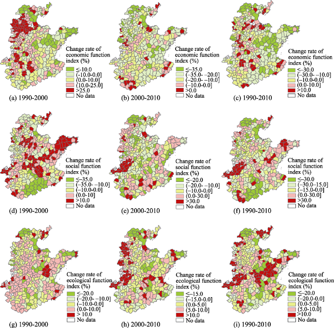
Using counties as the basic analysis unit, this study established an evaluation index system for farmland function (FF) from economic, social, and ecological perspectives. The method combining entropy weighting and multiple correlation coefficient weighting was adopted to determine the weights, and the FF indices were calculated for each county. Subsequently, the spatio-temporal characteristics of farmland function evolution (FFE) were analyzed and the coupled relationships between the sub-functions were explored based on a coupling coordination model. At the same time, the dynamic mechanism of FFE was quantitatively analyzed using a spatial econometric regression analysis method. The following major conclusions were drawn: (1) The farmland economic function generally exhibited a declining trend during 1990-2010, and it is essential to point out that it was stronger in underdeveloped and agriculture-dominated counties, while it continuously weakened in developed areas. Farmland social function decreased in 60.29% of the counties, whereas some counties, which were mostly located in north of Zhengzhou and west of Dezhou and Cangzhou, Yantai, and Weihai, clearly increased. A dramatic decline in farmland ecological function occurred around Beijing, Tianjin, and Jinan. Areas located in the northern part of Henan Province and the central part of Shandong Province saw an increase in ecological function. (2) There was a significant spatial difference in the coupling degree and coordination degree of the sub-functions, and the decoupling phenomenon highlighted this. The changes in social function and ecological function lagged behind economic function in developed areas, but these were highly coupled in some underdeveloped areas. (3) FFE in the Huang-Huai-Hai Plain (HHHP) is resulted from the comprehensive effects of regional basic conditions and external driving factors. Furthermore, the transitions of population and industry under urbanization and industrialization played a decisive role in the evolution intensity and direction of farmland sub-systems, including the economy, society, and the ecology. According to the results mentioned above, promoting the transformation from traditional agriculture to modern agriculture should be regarded as an important engine driving sustainable development in the HHHP. Taking different regional characteristics of FFE into account, differentiated and diversified farmland use and management plans should be implemented from more developed urban areas to underdeveloped traditional agricultural areas.

Cite this article

ZHANG Yingnan , LONG Hualou , MA Li , GE Dazhuan , TU Shuangshuang , QU Yi . Farmland function evolution in the Huang-Huai-Hai Plain: Processes, patterns and mechanisms[J]. Journal of Geographical Sciences, 2018 , 28(6) : 759 -777 . DOI: 10.1007/s11442-018-1503-z

1 Introduction

Since the 1990s, China’s rural-urban spatial and industrial structures have rapidly transformed (Long et al., 2016). The convergence of population and industry has fueled the expansion of urban space (Li et al., 2017). The transfer of rural-urban elements has resulted in serious problems, including farmland nonagriculturalization, non-grain preference, extensive cultivation, and farmland marginalization (Song, 2017). The disorderly competition between the great demand and limitied farmland resources, as well as the management mode that neglecting the derivative functions, have caused a series of eco-environmental problems, such as land degeneration, soil acidification (Song et al., 2014). Traditonal farmland management mode oriented around a single function is incompatible with the multiple demands of urban-rural residents (Ülo et al., 2007). Exploring new land management policies from the perspective of multifunctional land management has aroused wide attention among numerous scholars (Jongeneel et al., 2008). In recent years, a large number of researches have been conducted on farmland function (FF) (Song and Ouyang, 2012a; Vereijken, 2003; Jiang et al., 2011), such as impact assessments (Sal and García, 2007; Potschin and Haines-Young, 2008; Todorova and Ikova, 2014), farmland value estimation (Rong et al., 2014), spatio-temporal evolution (Song et al., 2015; Yang and Tan, 2014), and multifunctional farmland management (Song and Ouyang, 2012b). With regard to single functions, existing studies have mainly been concerned with the functions of social security (Wu et al., 2013) and ecosystem services (Song et al., 2013). Few scholars subdivide economic and social functions into more detailed components for in-depth study (Chen et al., 2016; Ke et al., 2016). Furthermore, only a minority of scholars have explored the coupled relationships between socio-economic development and function change (Tian, 2014), and quantitative analysis is rarely applied in these studies.
Farmland use system, which combines economic, social, and ecological sub-systems, generally functions as promoting economic growth, sustaining social prosperity, and conserving eco-environment (Zhou et al., 2016). And the three sub-systems of that show symbiosis and synergy relationships in normal circumstances. Although multifunctional farmland transitions have generally occurred in China, the decoupling between the sub-functions that has resulted from unmatched supply and demand, and morphological distortion, is becoming increasingly prominent (Song et al., 2015). Undoubtedly, the Huang-Huai-Hai Plain (HHHP), one of the main grain-producing areas, plays an important role in national food security. In 2014, farmland area in this region amounted to 27.42 million hm2, which accounted for 65.8% of the total land area and 81.81% of the ecological land in the HHHP. The per capita farmland area was about 1100 m2, which was 8.5% higher than the national average. During 1990-2014, farmland area decreased by 150 thousand hm2 annually and the farmland nonagriculturalization rate reached 18%. In 2014, the area planted with grain was 23.19 million hm2 and was 1.38% higher than that in 1990, but the proportion of grain in the total crop area reduced from 80.98% to 73.49%. The increasing grain demand imposes enormous pressure on farmland and water resources, thus causing serious environmental deterioration and groundwater level decline (Liu et al., 2015). The water resources per unit farmland area are about 1/8 of the national average and the largest groundwater depression funnel appeared in the HHHP (Zhang and Kong, 2014). With rapid urbanization and industrialization, and sharp urban expansion, critical food security issues and the diverse demands of urban-rural residents pose great challenges to sustainable and multifunctional land use (Liu et al., 2014). Therefore, this paper chose counties as the basic unit to explore the spatio-temporal characteristics and dynamic mechanisms of farmland function evolution (FFE) in the HHHP. Based on the spatio-temporal patterns of each sub-function, a coupling coordination model was adopted to analyze the coupling relationship between the three sub-functions. Finally, the dynamic mechanisms for FFE were quantitatively analyzed using spatial econometric regression. Carrying out this research at the county level provided a detailed depiction of regional differences and was of significance in farmland spatial allocation, multifunctional land management, and providing scientific support for sustainable land use.

2 Study area and data sources

2.1 Study area

The HHHP, one of the main grain-producing areas for agricultural products, stretches across seven provinces, including Beijing, Tianjin, Shandong, Hebei, Henan, Anhui, and Jiangsu (Figure 1). Suitable climatic conditions and abundant farmland resources have generated a unique dense rural population. The number of rural residents was approximately 180 million in 2014, which accounted for 80.92% of the total in the HHHP and 29.11% of the total rural population in China. The number of rural employees was over 110 million, and the proportion of employees who engaged in primary, secondary, and tertiary industries was 1:0.45:0.40. With the development of agriculture, the added value of the primary industry made up 13.29% of GDP and the per-capita net income for farmers was about 11,000 yuan. Additionally, challenges to the growth of grain yield, including farmland nonagriculturalization and non-grain preference, have become the foremost factors that limit regional sustainable socio-economic development.
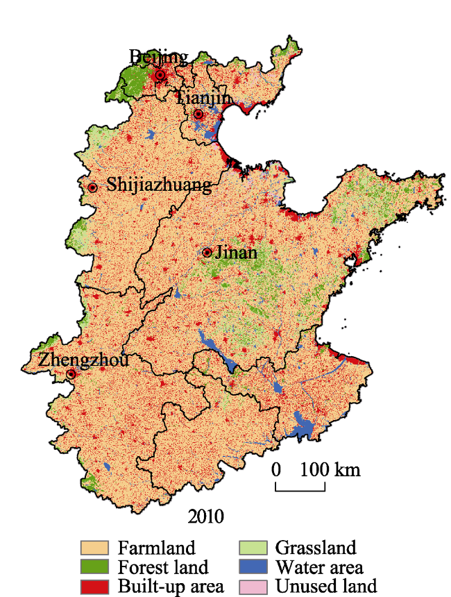
Figure 1 Regional profile of the study area

2.2 Data sources

Vector data for land use (1990, 2000, and 2010) that adopted the standard land use classification system published in 2007 (GB/T 21010-2007) was interpreted from Landsat TM images with a spatial resolution of 30 m×30 m provided by the Ministry of Land and Resources of the People’s Republic of China. Socio-economic data at the county level mainly originated from China Statistical Yearbook (County Level) (2001-2011), China Statistical Yearbook for Regional Economy (2001-2011), and Statistical Summary of the Rural Economy at the County Level (1991). Population data was obtained from 2010 Population Census Data of China, 2000 Census Data of the Cities or Counties, 1990 Census Data of the Cities or Counties, and China Statistical Yearbook (1990, 2000, and 2010). In the process of preparing the dataset, the statistic yearbook for each province was used to ensure the accuracy of the data when revising and checking. A digital elevation model (DEM) for calculating the average elevation of each county, major rivers, and average precipitation was derived from the National Geomatics Center of China (http://nfgis.nsdi.gov.cn). The potential crop yield of China, and vector data for highways and railways, were provided by Data Center for Resources and Environmental Sciences, Chinese Academy of Sciences (RESDC) (http://www.resdc.cn). Considering the adjustment of administrative divisions and the fact that a small number of counties lack socio-economic data, some municipal districts and counties were removed from this study, leaving a final total of 340 counties.

3 Concept and methodology

3.1 Farmland function

Meeting the demands of subsistence and development, which is regarded as the essence of FF, is both the endogenous dynamic and the ultimate goal of farmland development and utilization (Song and Ouyang, 2012b). Farmland management with both commodity and non-commodity output results in a multifunctional complex of material production and non-material production. The demand for farmland tends to be diversified and high-end as the advancement of society and the economy, which reflects the transformation from emphasizing traditional economic value to focusing on the multiple values of the economy, society, and ecology. Based on grain or other cash crop production, the economic function brings financial gains to rural households and promotes national economic development. Generally, social function indirectly manifests as providing basic employment for farmers, maintaining social stability, and ensuring food security. Undoubtedly, farmland plays an important role in ensuring regional and national food security because of its status of major production base of agricultural products. Therefore, the function of ensuring food security was not taken into consideration, while the function of guaranteeing employment was emphasized in this paper. Ecological function mainly embodies as preserving biological diversity, regulating the climate, purifying the environment, maintaining the resilience of field ecosystems, and enhancing the landscape esthetic. Farmland, the functions of which are constrained by multiple factors, such as human activity, individual concept and consciousness, regional cultural traditions, socio-economic systems and policies, and farmland ecosystem carrying capacity, is the coupling of the natural ecological sub-system and the artificial sub-system. Furthermore, an FF system is a synthesis formed by interrelated and interacting sub-functions, rather than the simple superposition of every single function (Matson et al., 1997; Zhou et al., 2016).

3.2 Assessing farmland functions

3.2.1 Establishing an evaluation index system
Considering data accessibility and the difficulty of quantification, an evaluation index system covering economic, social, and ecological functions was established by following scientific, systematic, and hierarchical principles (Table 1). (1) In order to evaluate economic function scientifically, the yield, output value, and potential crop yield of farmland were taken into consideration. The output value of crop farming (lópez-ridaura et al., 2005; Fleskens et al., 2009) and grain yield per unit farmland area (Sal and García, 2007; Tan, 2014) comprehensively reflect the output level affected by natural conditions and varying degrees of input production factors. Based on farmland spatial distribution, soil conditions, and elevation, the GAEZ (Global Agro-Ecological Zones) model, which incorporates natural factors, pest, and disease damage, was adopted to calculate potential farmland crop yield (Evans and Fischer, 1999). (2) When selecting the indices for social function evaluation, the emphasis was placed on farmland carrying capacity of rural labor employment and the effects of agricultural mechanization on farmers’ employment. As a rule, the larger the per capita farmland area is, the stronger its employment absorption capacity (Song, 2013; Hu et al., 2014). Small-scale and dispersive management with lower earnings gives rise to the transfer of rural labor from traditional agriculture to non-agricultural industries. The proportion of workers who engaged in agriculture, forestry, animal husbandry, and fisheries can directly reflect the reliance of famers on farmland (Luo and Cai, 2016; Li and Han, 2007). The total power of agricultural machinery per unit farmland area is the firsthand measurement of agricultural mechanization (Verma, 2006; Zhu, 2005). The increase of labor-saving inputs may lower the dependence of agricultural production and management on rural labor, thus weakening the employment carrying capacity of farmland. Ecological pressures due to yield-increasing inputs and population growth, which were depicted by the excess fertilizer input and the quantity of population per unit farmland area, were taken into consideration when selecting indicators for measuring ecological function. The percentage of farmland in ecological lands represents the importance of farmland to eco-environmental security, due to the large share of farmland in the HHHP (Sun et al., 2007). In the process of evaluating landscape aesthetic function, the concentration of farmland and accessibility were emphasized, and the relief amplitude was ignored due to the flat terrain and smaller spatial heterogeneity in the HHHP (Peng et al., 2016). It is generally accepted that centralized and contiguous farmland has greater aesthetic value. Farmland is more attractive for urban residents compared to rural residents. However, distance and accessibility determine where urban dwellers will go.
Table 1 The evaluation index system for FF
Criteria Index Unit Direction Weight3)
Economic function
index
Grain yield per unit farmland area ton/hm2 + 0.29
Output value of crop farming per unit farmland area yuan/hm2 + 0.28
Potential crop yield of farmland kg/hm2 + 0.43
Social function index Per capita farmland area hm2/person + 0.53
Proportion of the employees who engaged in agriculture, forestry, animal husbandry, and fisheries in the total number of rural employees % + 0.21
Total power of agriculture machinery per unit farmland area kW·h/hm2 - 0.26
Ecological function
index
The equivalent quantity of fertilizer input per unit farmland area exceeds the upper limit of the safety standard of fertilizer input per unit farmland area1) kg/hm2 - 0.17
Population per unit farmland area Person/hm2 - 0.25
Percentage of farmland in ecological land2) hm2 + 0.32
Function index of landscape aesthetics - + 0.26

Note: 1) The upper limit of the international safety standard of fertilizer input per unit farmland area is 225 kg/hm2; 2) Ecological lands mentioned in this paper include farmland, forest land, grassland, water bodies, and unused land (Long et al., 2015); 3) A method combining entropy weighting and multiple correlation coefficient weighting was used to determine indices’ weights (Luo and Cai, 2016).

3.2.2 Calculating FF index
The first step was to standardize the evaluation indicators using the maximum difference normalization method. Then, each sub-function index was calculated by the formulas below:
$\begin{align}& F(econ)=\sum\limits_{i=1}^{n}{w{{(econ)}_{i}}*f{{(econ)}_{i}}}\ or\ F(soci)=\sum\limits_{i=1}^{n}{w{{(soci)}_{i}}*f{{(soci)}_{i}}} \\ & or\ F(ecol)=\sum\limits_{i=1}^{n}{w{{(ecol)}_{i}}*f{{(ecol)}_{i}}} \\ \end{align}$ (1)
where F(econ), F(soci), and F(ecol) represent economic, social, and ecological function indices, respectively. Similarly, w(econ)i, w(soci)i and w(ecol)i are the weights of index i for each sub-function, respectively; and f(econ)i, f(soci)i and f(ecol)i are the respective standardized index values. F(econ), F(soci), and F(ecol) range from 0 to 1, and the larger the value, the stronger the corresponding sub-function is.

3.3 The coupling pattern of FFE

There are relationships of relevance, influence, and constraints among economic, social, and ecological functions, which may have positive or negative effects on each other. Although a multi-factor comprehensive evaluation method may reflect the comprehensive function of farmland, it is unable to directly describe the coupling and coordination degree among the sub-functions (Yang et al., 2015). Hence, a coupling and coordination model was used to quantitatively depict the strength of the interaction between the three sub-functions and reveal the state of synergetic evolvement (Liu et al., 2011). The formula for the coupling degree model is as follows:
$C={{\left[ {(F(econ)*F(soci)*F(ecol))}/{{{\left( \frac{F(econ)+F(soci)+F(ecol)}{3} \right)}^{3}}}\; \right]}^{1/3}}$ (2)
where C is the coupling degree, which varies between 0 and 1. When C = 0, this means the relationship between the three sub-functions is disordered. On the contrary, when C = 1, the coupling degree of each sub-function reaches the maximum, which means that they are fully coupled.
In order to further explore the degree of coordinated development, a coordination model was used, and the formula is below:
D=(C*T)1/2, $T=\alpha *F(econ)+\beta *F(soci)+\gamma *F(ecol) $ (3)
where C is the coupling degree and D is the coordination degree; T is the comprehensive evaluation index of farmland functions. A method combining entropy weighting and multiple correlation coefficients weighting was used to calculate weights. The values of α, β, and γ were 0.21, 0.40, and 0.39, respectively.

3.4 The selection of driving factors and quantitative recognition method

3.4.1 Driving factors
FFE is the result of the interactions and influence between regional indigenous factors and external driving factors. The state of FFE is determined by the power of driving forces. Topography, climate, hydrology, and farmland resources are the basic natural factors that provide support for FFE. Urbanization, industrialization, agricultural modernization, and regional development policies are the external factors that give impetus to the FFE by boosting the flow of urban-rural elements and industrial interaction (Figure 2).
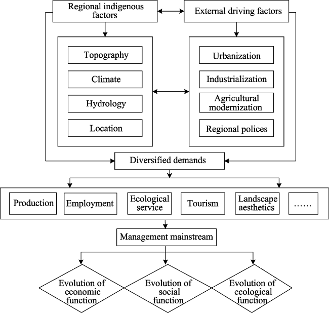
Figure 2 The conceptual framework for the dynamic mechanisms of FFE
Regional indigenous factors: (1) Natural conditions, which are regarded as the prerequisite of farmland use, fundamentally affect agricultural production and resource supply capacity. In spite of the fact that the change in natural factors is weak and not very obvious over the short term, farmland productivity varies widely because of the large span from the south to the north and clear regional differences of precipitation in the HHHP. Accordingly, elevation, average annual precipitation and distance from major rivers were selected as the major natural driving factors. (2) Transportation accessibility is an effective indicator to estimate location advantage. Hence, distances to national, provincial, and county roads were used to provide a comprehensive estimation of regional transportation accessibility.
External driving factors: (1) It is universally acknowledged that establishing a multidimensional evaluation index system of urbanization covering the economy, society, and space (land) is a difficult task at county level due to the overwhelming obstacle of collecting socio-economic statistical data. Considering the powerful effects of urbanization on surrounding regions, this paper first established an evaluation index system for urbanization level at the level of the prefecture (Table 2). In order to avoid repetition in indices, indices related to industrialization were not involved in the economic urbanization evaluation index system. Next, prefecture-level cities were classified into five levels according to their comprehensive influence (Figure 3). Then, the scores associated with their influence received from corresponding core cities were calculated using a linear attenuation model that was based on the influential sphere of core cities designated by the Weighted Voronoi Method (Gu et al., 2014). (2) The number of industrial enterprises per unit land area and percentage of industrial added value in GDP at county level was used to indicate the industrialization level. (3) The increase in yield-increasing and labor-saving inputs triggered by agricultural modernization boosted farmland productivity and the de-agriculturalization transfer of rural labor. Simultaneously, excessive fertilizer inputs can cause severe agriculture non-point source pollution and threaten farmland ecosystems. (4) Regional development policies regarding farmland protection, balancing urban and rural construction land, grain purchasing and storage, water-saving agriculture and environmental agriculture, exerted limitation or guidance on FFE.
Table 2 The evaluation index system for urbanization level
Criterion Index Unit Direction Weight1)
GDP per unit land area in municipal districts 10,000 yuan/km2 + 0.12
Economic
urbanization
GDP per capita yuan/person + 0.11
Percentage of tertiary industry added value in GDP % + 0.07
Total retail sales of consumer goods per capita in municipal districts yuan/person + 0.03
Fixed assets investment per capita yuan/person + 0.05
Social
urbanization
The number of beds in medical and health institutions per million people - + 0.08
The number of buses per million people - + 0.04
Local fiscal expenditure per capita yuan/person + 0.10
Land
urbanization
Proportion of built-up area % + 0.13
Built-up area per capita m2/person + 0.13
Urban road area per capita in municipal districts m2/person + 0.12

Note: 1) The method combining entropy weighting and multiple correlation coefficients weighting was used to determine indices’ weights.

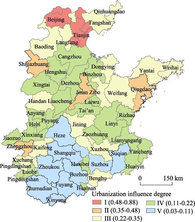
Figure 3 Urbanization influence classification for cities in the HHHP
Farmland management mainstream: As the management mainstream of farmland, rural population has the dual status of producer and customer. The proportion of the rural population and the proportion of the population with an educational level above junior middle school in the total population were adopted to show the peculiarities of farmland management mainstream from the perspective of quantity and quality.
3.4.2 Spatial econometric regression analysis
In light of the relevance of the sub-function indices for different regions, the use of a spatial econometric model to explore their influencing factors can make up for the disadvantages of a traditional econometric model, because it explores the spatial correlation among explanatory variables or random error terms (Anselin, 1998). There are many kinds of spatial econometric models. Spatial constant coefficient models, including a Spatial Lag Model (SLM) and a Spatial Error Model (SEM) (Fang et al., 2013), were chosen for this study.

4 Results

4.1 Spatio-temporal characteristics of FFE

4.1.1 Spatio-temporal patterns of FFE
Spatio-temporal patterns of economic function evolution: Economic function in the HHHP generally weakened during 1990-2010 and showed prominent spatial differentiation between growing areas and declining areas. Economic function generally increased and the rate of change was normally distributed. The regions of growth mainly concentrated in the central part of Hebei, eastern Henan, and western Shandong, while decreasing areas were mostly distributed in and around the Beijing-Tianjin metropolitan area, the Yantai-Weihai urban area, and Jinan (Figures 4a and 5a). Skewness and Kurtosis clearly increased due to the sharp increase of economic function in some counties during 2000-2010 (Figures 4b and 5b). Compared to the last period, the number of growing counties significantly reduced, and nearly 92.06% of the counties experienced a decline in economic function, while the remaining 27 increasing counties mainly scattered around the southern part of Hebei and Henan. During 1990-2010, the growth areas were mainly located in the central and southern part of Hebei and eastern Henan (Figures 4c and 5c). The last 20 years have witnessed a continuous decline in areas surrounding Beijing and Tianjin, Yantai-Weihai, and Jinan, which were deeply affected by urbanization and industrialization. Meanwhile, agricultural production efficiency was low in northern Anhui Province because of the larger proportion of traditional agriculture and the smaller fraction of high efficiency facility agriculture and leisure agriculture.
Spatio-temporal patterns of farmland social function evolution: 51.18% of the counties experienced a clear decrease in social function, which were mainly distributed around the northern Anhui and the Beijing-Tianjin metropolitan area (Figures 4d and 5d). Counties that experienced an enhancement in social function, the number of which was 83, were mostly concentrated in the west of Cangzhou, Yantai, Weihai, Jining, Linyi, and Weifang. During 2000-2010, the number of growing counties dropped by 10%, while traditional growth areas, including Weifang, Yantai, and the northern part of Zhengzhou, still maintained a rather strong growth trend. Some regions with extremely high growth rates gave rise to the significant peak and fat tail of the density map. The spatial patterns of social function change during 1990-2010 (Figure 4f) was roughly the same as that during 2000-2010; meanwhile, a small set of cities including Dezhou, Cangzhou, and Hengshui declined somewhat during 2000-2010. The social function index change rate for 89.12% of the counties ranged from -35% to 35%, and Skewness and Kurtosis fell compared to 2000-2010 (Figure 5f). The developed rural areas surrounding Beijing and Tianjin were dominated by industry and commerce. The rapid development of rural industry and tourism, coupling with scarce farmland resources and the high proportion of non-agricultural employment, contributed to the continuous decline of employment carrying capacity. Rural areas with high population density, high population growth rate, and lagged non-agricultural industries underwent reductions in their social function indices due to urbanization and industrialization, compared to their high baseline of index values. Where there were low levels of agricultural industrialization or imperfect industrialization, rural populations in Xinxiang, Jiaozuo, Hebi, Anyang, Zhoukou, and Zhumadian in Henan were still highly dependent on farmland. Yantai, Weihai, and their adjacent hilly areas in east Shandong Peninsula were characterized by large farming areas per capita and high proportion of the cash crop. Relatively-developed modern agriculture, urban agriculture, and ecological agriculture jointly affected the employment choices of the rural population in these areas to a great degree.
Figure 4 The spatial patterns of the change rate of FF in the HHHP during 1990-2010
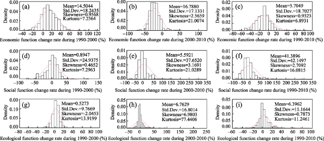
Figure 5 The density graphic of the change rate of FF index in the HHHP
Spatio-temporal patterns of ecological function evolution: Ecological function evolution was characterized by a larger fluctuation and clear differences in spatial patterns between different periods. Of all the counties, 47.35% experienced ecological function declines, especially around Beijing-Tianjin, the east of Shandong, and the north of Anhui (Figures 4g and 5g). Growth areas mainly concentrated in the north and south of Henan, and the east and west of Shandong. The sharp increase in farmland area of most counties in Yantai, Weihai, and Qingdao showed that farmland played a significant role in environmental conservation. Abundant farmland and lower fertilizer and pesticide inputs jointly contributed to the increase in ecological function. Change rates of ecological function varied between -50% and 50% during 2000-2010 (Figures 4h and 5h), while the Kurtosis reached 77.44 due to the outliers, which caused the high peak and fat tail on the density map. During this period, the growth areas were mainly distributed in western Hebei, northern Henan, and northern Anhui. During 1990-2010, the core areas of growth centered around northern Henan and central Shandong, and areas around Beijing, Tianjin, and Jinan were the primary decreasing areas.
4.1.2 Spatio-temporal characteristics of the coupling effect among economic, social, and ecological functions
The “economy-society-ecology” composite system of farmland is open, dynamic, and complex, and if one component is out of order it would result in the decline of system coordination and cause its deviation from the given targets. (1) Economic function was closely associated with natural property and human management activities. Productivity can be modified by the input of various elements and changes in utilization. Driven by the multiple goals of guaranteeing food security, increasing farmers’ income and promoting grain production, pesticides, fertilizers, and agricultural machinery certainly will increase if agricultural technology is improved. Moderate pesticide, fertilizer, and other yield-increasing inputs will either enhance the farmland productivity or prevent farmland ecosystem degradation. Increasing labor-saving inputs directly promote agricultural production and free more rural labor from cultivation affairs, as well weaken traditional labor intensive agriculture. (2) Farming is the last guarantee for peasants to get employment. As such, it is farmers who realize the economic value of farmland. Modern agricultural practices, such as urban and ecological agriculture, lead to localized employment and directly motivate the efficient utilization and intensive management of farmland. Meanwhile, if farmland carried excessive population, it would initiate agricultural involution, which is against the promotion of agricultural productivity and rural economic development. Similarly, the dual effects of population growth and farmland decreasing jointly exert pressure on existing farmland. (3) A favorable farmland environment is a basic condition and support for maximizing its socio-economic functions. On the contrary, environmental damages, such as soil salinization, soil erosion, heavy metal pollution, and agricultural non-point source pollution will constrain agricultural production.
The synergistic evolution of the population, land use, and industry inevitably coincides with the changing interactions among farmland economic, social, and ecological sub-systems (Figure 6). The results from the coupling degree model showed that there was clear spatial variation in coupling degree (Figures 7a, 7b and 7c). (1) Areas with a coupling degree greater than 0.6 were in high numbers, widely distributed, and concentrated. Affected by urbanization and industrialization, traditional agriculture contributed less to national economic growth and rural household income. The nearly equivalent de-agriculturalization rates of land, population, and industry made a smaller difference among farmland sub-function indices for most counties across different periods, thus creating the high coupling degree. (2) Areas with a low coupling index were mainly concentrated around Beijing, Tianjin, Jinan, Yantai, and Weihai. Compared to 1990, the coupling degrees in 2000 and 2010 were relatively lower. The decline of primary industry and the rise of industry and commerce jointly triggered the transition in employment structure. Farmland sub-functions diverged as farmland was continuously encroached by construction land, which caused the coupling degree decrease. (3) From the viewpoint of temporal evolution, the coupling degree of the sub-functions shown a general downward trend, especially in the areas surrounding Beijing and Tianjin. Areas with high coupling degree shrank as a result of the unbalanced performance of the sub-functions.
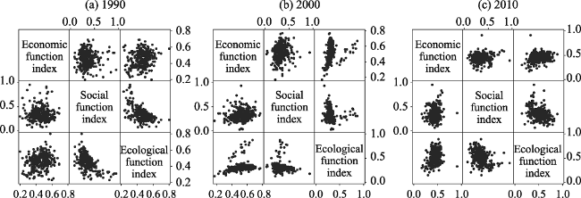
Figure 6 The matrix scatter diagram of farmland economic, social, and ecological function indices in the HHHP in 1990, 2000 and 2010
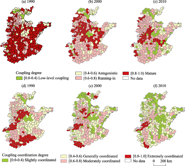
Figure 7 The spatial distribution of the coupling and coordination degrees for farmland economic, social, and ecological functions in the HHHP in 1990, 2000, and 2010
In order to conduct further research on the coupling and coordination relationships between the three sub-functions mentioned above, a coupling coordination model was adopted to comprehensively analyze the coordination level. The results showed that: (1) Compared to coupling degree, areas with corresponding value intervals shrank dramatically and the low value zones expanded. (2) Counties with a high coupling coordination degree were mainly located in Dezhou, Hengshui, southern Henan, northern Anhui, and other undeveloped areas dominated by traditional agriculture. In general, most counties in the Shandong Peninsula underwent sustainable economic, social, and ecological development through the transformation and upgrade of traditional agriculture, forming an advanced coupling morphology rather than underdeveloped areas with high dependence on farmland for socio-economic development. (3) When it comes to dynamic evolution, initial areas with high values gradually shrank and areas with low values expanded around the original center. The farmland sub-functions of economy, society, and ecology gradually were differentiated by de-agriculturalization of population, land and industry. Abundant farmland resources and agricultural modernization enhanced economic function. The migration of surplus rural labor and the decline in people engaging in agriculture brought the farmland socio-economic function index down, and resulted in the decline of coupling coordination degree.

4.2 The dynamic mechanisms of FFE

The economic, social, and ecological function indices, along with the explanatory variables, were imported into GeoDa and analyzed using Ordinary Least Squares (OLS), SLM, and SEM to explore the driving factors of FFE. Model selection was based on the results of a spatial correlation test. If Moran’s I and LR-LM Lag were significant, the LR-LM Error was not significant, and the LM-Lag was larger than the LM-Error, SLM was chosen; otherwise, SEM was chosen. Log L likelihood (Log L), Likelihood Ratio (LR), the Akaike information criterion (AIC), and the Schwartz Criterion (SC) are usually taken into consideration in the process of model selection. The larger the Log L is, and the smaller the AIC and SC are, the better the fit (Liu and Long, 2016). These indicators were also used to compare OLS, SLM, and SEM, and the largest Log L represents the most appropriate choice. According to the results (Table 3), SEM was more suitable for explaining economic and ecological function evolution, and SLM was more appropriate for social function evolution.
Table 3 Results of spatial correlation tests for FFE in the HHHP
Spatial dependence test Economic function Social function Ecological function
Moran’s I (error) 9.8575*** 6.7193*** 9.2617***
Lagrange Multiplier (lag) 38.4304*** 28.1586*** 19.1501***
Robust LM (lag) 1.7955* 5.3022** 2.3325
Lagrange Multiplier (error) 54.1750*** 23.0057*** 47.2461***
Robust LM (error) 17.5401*** 0.1493 30.4286***
Lagrange Multiplier (SARMA) 55.9706*** 28.3079*** 49.5786***

Note: *: Significant correlation at the 10% level; **: Significant correlation at the 5% level; ***: Significant correlation at the 1% level.

The spatial econometric analysis results at the county level indicated that regional indigenous factors and external driving factors jointly determined the direction and extent of FFE. The specific dynamic mechanisms of economic, social, and ecological function evolution are as follows (Table 4).
Table 4 The spatial regression analysis results for FFE and influence factors in the HHHP
Factors Economic function Social function Ecological function
OLS SLM SEM OLS SLM SEM OLS SLM SEM
Elevation -0.13
**
-0.18
***
-0.31
*
0.13 -0.06 -0.05 -0.49
***
-0.42
***
-0.58
***
Distance from major rivers 0.04 0.03 -0.23 -0.06 -0.01 0.11 0.25
***
0.12
**
0.06
**
Precipitation 0.07
**
0.05
**
0.27
**
0.07 0.05 0.30 0.006
**
0.01
**
0.20
**
Traffic
accessibility
-0.13
***
-0.13
***
-0.13
***
-0.05
**
-0.06
**
-0.06
**
- - -
The number of industrial enterprises per unit land area -0.14
**
-0.07
*
-0.13
***
-0.19
**
-0.13
**
0.08
***
-0.07
**
-0.10
**
-0.08
***
Percentage of industrial added value in GDP -0.22
**
-0.14
*
-0.12
***
-0.09
***
-0.11
***
-0.13*** -0.24
***
-0.21
**
-0.20
***
Proportion of rural population 0.15 0.14 0.17 0.20
***
0.19
***
0.20
***
-0.04
**
-0.03
**
-0.02
**
Education level 0.002 0.001 0.001 -0.003
***
-0.002
***
-0.002
***
-0.001 -0.01 -0.01
Urbanization influence index -0.15
***
-0.119
***
-0.11
***
-0.076
**
-0.06
**
-0.06
***
-0.07
***
-0.06
**
-0.09
**
W-Y 0.71
***
0.67
***
0.61
***
Lambda 0.88
***
0.81
***
0.84
***
R2 0.19 0.33 0.41 0.23 0.34 0.36 0.42 0.49 0.55
Log-L 210.86 233.29 245.89 258.16 275.32 277.62 241.30 255.81 267.81
AIC -401.71 -444.58 -471.78 -496.32 -528.64 -535.23 -462.61 -489.62 -515.62
SC -365.16 -404.37 -435.22 -459.76 -488.43 -498.67 -426.05 -449.40 -479.06

Note: *: Significant correlation at the 10% level; **: Significant correlation at the 5% level; ***: Significant correlation at the 1% level

Economic function had a clear positive correlation with traffic accessibility, the number of industrial enterprises per unit land area, percentage of industrial added value in GDP, and urbanization influence index at a significance level of 1%, as well as average annual precipitation at a significance level of 5%. Additionally, it had a negative correlation with elevation at a significance level of 10%, and there was no significant correlation with distance from major rivers, the proportion of rural population, and education level. (1) Compared to the plain areas, hilly areas were characterized by scarce and scattered farmland, high levels of difficulty for automated cultivation, and expensive irrigation costs, which severely restricted agricultural management and reduced the efficiency of farmland utilization. For instance, Fangshan and Shunyi counties, which are located around Beijing, developed a prosperous valley economy, and planting became a minor choice for farmers. Specialized tourism and
other non-agricultural industries relying on the location advantage of metropolitan suburbs and specialized resources of mountain areas, have become the main source of farmers’ income. (2) Theoretically, precipitation is positively correlated with farmland production capacity, but the average annual precipitation showed a decreasing trend from south to north, and from the coastal areas to inland areas. Due to the export-oriented economy, coastal areas had higher levels of urbanization and industrialization, which caused agriculture weaken in the national and rural household economies. (3) With the implementation of high standard basic farmland construction, distance from major rivers was no longer a constraint for field irrigation due to the improvement in irrigation facilities. (4) Favorable location nearby regional central cities was a prerequisite for economic growth. The boom in non-agricultural industries was motivated by the transfer of capital, information, technology and, talents from metropolitan regions to the surrounding areas. (5) Impacts of industrialization imposed on economic function were summarized into two points. On the one hand, the rapid increase in the proportion of industrial outputs in GDP reduced the proportion of agricultural outputs. On the other hand, so much high quality farmland was occupied that the economic output declined. (6) The increasing frequency of urban and rural interactions, the accelerated flows of economic elements, and the rapid development of non-agricultural industries were attributed to changes in industry structure, and manifested as an increase in urbanization rate. The increasing demand for residential land, public services, and infrastructure induced by population growth in urban areas, resulted in the loss of farmland and a decline in economic function. It should be noted that economic function of areas oriented around traditional agriculture was enhanced because of the promotion of agricultural industrialization and modernization, but across the entire HHHP it generally declined.
Social function evolution did not have a significant correlation with natural factors, but it was negatively correlated with traffic accessibility, the number of industrial enterprises per unit land area, and the urbanization influence index at a significance level of 5%, while percentage of industrial added value in GDP and education level were correlated at a significance level of 1%. Additionally, social function had a strong positive correlation with the proportion of rural population at a significance level of 1%. 1) Well-equipped transportation networks in favor of rural-urban migration, promoted part-time farming and employment de-agriculturalization of surplus rural labor. 2) In the process of industrialization and urbanization, working in cites turns to be the best choice for rural middle-aged labor driven by increasing labor demand of industry development. Moreover, the increasing number of land-deprived residents who were compelled to leave agriculture became the primary reason for the weakening of farmland social function. 3) Farmland management was still the main way of maintaining minimum subsistence levels and resisting social risks due to the large and dense rural population in the HHHP. Human resources, whose capacity of getting employment was restrained by education level, were the most dynamic factor in rural development. Well-educated farmers may more easily adapt to multiple employment choices and reduce their dependence on farmland.
Ecological function evolution had a strong negative correlation with elevation. The number of industrial enterprises per unit land area, and the percentage of industrial added value in GDP at a significance level of 1%, and the proportion of rural population and the urbanization influence index were significant at the 5% level, but there was a positive correlation with distance from main rivers and average annual precipitation at a significance level of 5%. 1) Scarce farmland, together with land development in hilly areas resulted in the decline of the proportion of ecological farmland. 2) Extensive economic growth, excessive resource exploitation, and poor management jointly caused disorderly development and soil and water pollution, which further led to the sharp drop in total farmland area and the degeneration of soil quality. Meanwhile, farmland ecosystems were further damaged by excessive fertilizer and pesticide inputs that for increasing grain yield. 3) Shrinking farmland areas and an increasing rural population imposed more pressure on farmland.

5 Discussion and conclusions

5.1 Discussion

(1) All sub-functions of farmland gradually declined due to urbanization and industrialization in the HHHP, while the value they possess was continuously improved in virtue of resource scarcity. Hence, a comprehensive understanding of FFE and the declining trend of some sub-functions is critical to achieving modern agriculture and upgrading traditional agriculture, as well as promoting endogenous development and increasing the efficiency of agricultural production.
(2) Multifunctional farmland use and management should be aimed at people’s diverse demand at given socio-economic development context. Dominant function transfer from economic and social oriented at a low socio-economic level to ecological and cultural oriented, while other derivative functions appear in company with the flourished non-agricultural industries. The decline of economic function is mainly attributed to construction land encroachment and the decreased status of agriculture in both national and household economy. More importantly, countermeasures such as improving basic mechanisms of land supply and planning, landscape design, and ecological design should be implemented to enhance farmland ecological function.
(3) In view of the existing obvious regional difference of FFE, distinguished and diversified multifunctional farmland use and management policies are needed to be proposed for optimizing the layout of farmland functions. Over emphasizing the requisition-compensation balance will result in superficial and shoddy balance of farmland area. In order to internalize the cost of farmland loss and enhance farmland ecological protection, it is necessary to develop ecological agriculture from the perspective of regional eco-environmental security. As for underdeveloped rural areas, advocating modern agriculture is an appropriate choice for promoting economic benefits and enhancing the capacity of labor absorption.
(4) Limited by the complexity of farmland system, there is still not a generalized and perfect FF classification system. A widely accepted classification system, which can provide the theoretical basis for FF assessment, urgently needs to be established. Current research on FFE mainly focuses on the macro scale rather than micro scale, such as the village and household. Therefore, studies of FFE from the micro perspective will be the emphasis of future research.

5.2 Conclusions

The spatio-temporal patterns of FFE had clear regional differences in the HHHP during 1990-2010. Economic function generally tended to decline, but was enhanced in underdeveloped areas that dominated by agriculture. Counties surrounding the Beijing and Tianjin metropolitan circle, Yantai, Weihai, and Jinan experienced a dramatic decline in economic function. However, farmland in counties around the north of Anhui failed to contribute more to economic growth on account of the lagging agricultural industrialization and modernization. 60.29% of the counties have experienced a decline in social function. And the increasing counties mostly concentrated in the north part of Zhengzhou and Dezhou, and the west part of Cangzhou, Yantai, and Weihai. The sharply decreasing areas of ecological function mainly gathered around Beijing, Tianjin and Jinan, while the areas of growth mostly concentrated in northern Henan and central Shandong.
The spatio-temporal pattern of coupling and coordination degree shows obvious spatial heterogeneity in the HHHP during 1990-2010, and the decoupling of sub-functions was getting prominent. The coupling and coordination degree of developed areas were lower than that of underdeveloped areas, and the evolution of social function and ecological function lagged behind economic function. Areas with high coupling and coordination degree were mainly distributed in underdeveloped rural areas with lagging population and industrial transitions, as well as rural areas, presenting balanced economic, social, and ecological performance.
Farmland multifunctional evolution was influenced by both regional indigenous factors and external driving factors. The direction and intensity of FFE were determined by population and industrial transitions in the course of urbanization and industrialization. Meanwhile, FFE was sustained by regional indigenous factors and promoted by rural development mainstream, who altered the behaviors of farmland use through employment option and diverse management modes.

The authors have declared that no competing interests exist.

[1]
Anselin L, 1988. Spatial Econometrics: Methods and Models. Dordrecht: Kluwer Academic Publishers.Spatial econometrics : methods and models by Luc Anselin (Studies in operational regional science, 4) Kluwer Academic Publishers, c1988 : pbk

DOI

[2]
Chen L, Hao J, Wang F.et al, 2016. Carbon sequestration function of cultivated land use system based on the carbon cycle for the Huang-Huai-Hai Plain.Resources Science, 38(6): 1039-1053. (in Chinese)Cultivated land carbon sequestration as an effective supplement to the terrestrial ecosystem is recognized;however,research on the carbon sequestration function of cultivated land has been conducted from the perspective of ecology. For example,carbon uptake and carbon release of vegetation and arable soil and carbon balance in agro- ecosystems is often a focus and there is a lack of research into the carbon sequestration of cultivated land from the viewpoint of land science. Here we built a basic research framework for the carbon sequestration function of cultivated land use for the Huang- Huai- Hai Plain based on the carbon cycle process of cultivated land use system theory. Then the carbon sequestration function was evaluated from three aspects of carbon sequestration ability,carbon sequestration efficiency and carbon sequestration dominance.The results suggest that the carbon sequestration function of cultivated land use can be known from four aspects:natural carbon sequestration ability,ideal carbon sequestration ability,practical carbon sequestration ability and regional carbon sequestration ability. The carbon sequestration of cultivated land use systems of the Huang-Huai-Hai Plain is a carbon sink. The carbon sequestration efficiency and carbon sequestration dominance degree are 2.5 and 0.85 respectively. The carbon sequestration function of cultivated land use system plays an irreplaceable role on the Huang-HuaiHai Plain,which should be a prominent function in this area. This study provides a new way of thinking about ecological function theory research for cultivated land,and support for promoting the ecological benefits of cultivated land,mitigating climate warming,and administering cultivated land ecology interregional compensation.

[3]
Evans L T, Fischer R A, 1999. Yield potential: Its definition, measurement, and significance.Crop Science, 39(6): 1544-1551.

DOI

[4]
Fang Y, Xie W, Lin Z, 2013. A spatial econometric analysis of impact of ICT on service innovation: Based on analysis of 21 cities in Guangdong Province.Acta Geographica Sinica, 68(8): 1119-1130. (in Chinese)ICT is changing the relationship between service producers and consumers and is altering the established geography of service provision.Conventional approaches to services place considerable emphasis on the co-location of service producers with consumers.ICT has the potential to sever the geographic relationship between production and consumption and to produce a 'new' service geography.This article focuses on the interaction between ICT adoption,service innovation and location.In this research,Guangdong Province was selected as the case region given it is one of the most important Chinese opening up and reform frontier regions.The empirical data comes from the Guangdong Statistical Yearbook,etc.,which covers the period 2001-2011.This article employs factor analysis and spatial econometrics techniques to explore the impact new forms of information communication technologies(ICT) have on the emerging geography of services in 21 cities in Guangdong Province,China.This research was summed up from the following five findings.First,the results identify a positive correlation between the level of service innovation and the level of ICT between the 21 cities.The analysis shows that across the province services are either dispersed or agglomerated.These differences are explained by variations in the levels of investment in ICT.Second,under the impact of spatial disparities and spatial diffusion,the spatial distribution of ICT and service innovation was convergent and divergent across the region.Third,spatial regression analysis was used to check the determinants of service innovation and this identified that service innovation was positive in mutually promoting inter-city interactions in the province.Fourth,amongst the determinants of domestic market demand,information technology,industrialization level,traffic accessibility,economic openness,the level of urbanization of service innovation is important.Fifth,the analysis reveals that the level of service innovation grows by 0.716% with every 1% growth in ICT.This has important implications for regional policy as improvements in ICT have a direct and measureable impact on service innovation and growth.

[5]
Fleskens L, Duarte F, Eicher I, 2009. A conceptual framework for the assessment of multiple functions of agro-ecosystems: A case study of Trás-os-Montes olive groves.Journal of Rural Studies, 25(1): 141-155.Multifunctionality in agriculture has received a lot of attention the last decade from researchers and policy-makers alike, perhaps most notably evidenced by the important changes made to the EU's Common Agricultural Policy. While the concept has been embraced by environmentalists envisioning positive impulses for decoupling and a range of local stakeholders recognizing implicit marketing opportunities involved, it has also been criticized as a mere argument in favour of disguised protectionism. Problematic in this discussion is the lack of an operationalising framework for the assessment of multiple functions. In this paper, we discuss such a framework and the role it can play in the decision-making process. Focusing on a case study about olive farming on sloping and mountainous land in northeastern Portugal, the contribution discusses methods for studying multiple functions of agro-ecosystems. While function assessment is presented from a research perspective, its relevance for stakeholders is also stressed here. By using the metaphor of a house, the method could appeal to a wide range of actors. In the case study, we conclude that olive groves on sloping and mountainous land particularly fall short in supplying ecological functions. They do however contribute significantly to the local economy, generate employment and perform an important role in maintaining the cultural landscape and identity, and are thus vital to regional development and to stop outmigration of the population. Policy-makers could use the function assessment tool to design effective cross-compliance rules and relevant agro-environmental measures to reinforce ecological and social functions, and to communicate ideas to other stakeholders. As such, it provides an extension of public debate and can reinforce decision-making by visualizing trends, development alternatives or scenarios. The role of research in this method is to facilitate dialogue between stakeholder groups and to feed the process with relevant indicators.

DOI

[6]
Gu J, Zhou T, Guo L, 2014. Urban influence regions and spatial relation of Beijing-Tianjin-Hebei Region based on Weighted Voronoi Diagram and Breakpoint Theory.Geography and Geo-information Science, 30(1): 65-69. (in Chinese)It is confirmed that the urban influence region is one of the important contents of researching the reciprocity between cities and regions.It also has a great significance to urban geography and urban planning.This paper selects indexes concerning about the city influence area,then utilizes PCA(Principal Component Analysis)and data transformation to quantify the influence power of cities in Beijing-Tianjin-Hebei Region finally,and calculates the urban influence area in virtue of the breakpoint theory and weighted Voronoi diagram.Because the previous methods for selecting regional central cities and dividing urban economic regions are not appropriate for analyzing local regions which contain megalopolis,this paper suggests dividing BeijingTianjin-Hebei Region by analyzing the relationship of grid in the weighted Voronoi diagram based on breakpoint theory.Finally Beijing-Tianjin-Hebei Region is divided into three urban economic regions with three central cities in the first rank and two central cities in the second rank,which provides a reference for urban planning and regional development in this region.

[7]
Hu R, Qiu D, Xie D.et al, 2014. Assessing the real value of farmland in China.Journal of Mountain Science, 11(5): 1218-1230.The preservation of farmland is a growing concern in China because the fact that China possesses limited land resources and the world’s largest population presents a clear contradiction. Only when...

DOI

[8]
Jiang G, Zhang F, Kong X.et al, 2011. The different levels and the protection of multi-functions of cultivated land.China Land Sciences, (8): 42-47. (in Chinese)The purpose of this study is to analyze the levels of the multi-functions of cultivated land and propose how to protect the multi-functions of cultivated land.Conductive reasoning and documentation methods were employed.The results indicated that the multi-functions of the cultivated land have different levels,which can be classified as basic function and secondary functions.And these functions are coupling with the development of socio-economy and the interests of stakeholders; the value of the multi-function can be explicated and developed by engineering design,layout optimization of multi-function,and the harmony mechanism of interest among different stakeholders.It is concluded that the cultivated land protection can be instructed by the levels of cultivated land multi-functions.The explication and development of the multi-function according to the socio-economy can promote the cultivated land protection.

[9]
Jongeneel R, Polman N, Slangen L, 2008. Why are Dutch farmers going multifunctional?Land Use Policy, 25(1): 81-94.Given that current European Union policy is to stimulate and facilitate multifunctional agriculture (European farm model), it would be useful to know why farmers decide to go multifunctional. This paper presents the results of research into the factors determining the adoption of multifunctional activities. It is based on a survey of 495 farms throughout the Netherlands. Binomial logit models were estimated for multifunctional activities in general and for four specific activities. It was found that trust in the government is an important explanatory factor for participation in nature conservation and tourism, but is less important for services and on-farm sales. Farm location is important for nature conservation, services, and tourism. But farmers see tourism as an invasion of ‘farmership’. Farmers who value land ownership highly are less likely to have nature conservation contracts, as then they lose property rights over their own land.

DOI

[10]
Ke X, Li H, Liu R.et al, 2016. Research on the spatial matching pattern of cultivated land landscape recreation function and accessibility in Wuhan.Resources and Environment in the Yangtze Basin, 25(5): 751-760. (in Chinese)Revealing the spatial matching pattern of supply capacity and accessibility of cultivated land landscape recreation function can provide the basis for rational distribution, development and utilization of cultivated land landscape recreation function. Taking Wuhan as an example, this paper used the index evaluation method and expert scoring method,combined with spatial analysis, to establish the research framework of spatial pattern of cultivated land landscape recreation function in Wuhan, from the supply potential of farmland landscape recreation function, accessibility and their spatial match. The results showed that:(1) The spatial distribution of the cultivated land landscape recreation supply potential in Wuhan is gradually decreasing from the center of the city edge;(2) The accessibility of cultivated land landscape function in Wuhan generally shows a distribution pattern of "mid-west high, edge low";(3) According to the spatial matching of supply potential and accessibility, the cultivated land landscape recreation service in Wuhan is divided into four categories:high supply-high accessibility, high supply-low accessibility, high accessibility-low supply and low accessibility- low supply; and these four categories accounted for 26.17%, 25.24%, 17.33%, and 31.26% of the research area, respectively.The study of the cultivated land landscape recreation function has important practical significance on reasonable development and utilization of cultivated land resources, promoting multi-functional use of cultivated land.

[11]
Li G, Han L, 2007. The social function and compensation basis of rural land.Shandong Social Sciences, (1): 73-75. (in Chinese)

[12]
Li H, Wu Y, Huang X.et al, 2017. Spatial-temporal evolution and classification of marginalization of cultivated land in the process of urbanization.Habitat International, 61: 1-8.61A classification of marginalization on the basis of elasticity of input and income is proposed.61The marginalization of cultivated land is classified into PIM, NIM and EIM.61Spatial-temporal evolution of marginalization of cultivated land is analyzed.61Policy suggestions are offered to effectively minimize cultivated land marginalization.

DOI

[13]
Liu H, Zhang Y, Zheng W, 2011. Evaluation on spatio-temporal development and interaction of intensive urban land use and urbanization: Case studies of the cities in the Bohai Rim Region.Geographical Research, 30(10): 1805-1817. (in Chinese)Land use intensity,land use type and land use form of the intensive urban land use in different cities,which reflect different levels of development in urbanization,have significant differences.What's more,optional intensity of urban land use is closely related to the urbanization level.Based on the coupling mechanism between intensive urban land use and urbanization,to promote the balance between them is the most important basis of achieving sustainable development.Based on the interaction between intensive urban land use and urbanization,we evaluated index of the intensive urban land use coefficient,the urbanization and the harmonious degree quantitatively by factor analysis with the aid of SPSS16,then set up the degree model of harmonious development.We divided the harmonious degrees into the antagonism,the compromise and the coordination,comprising of three stages.Then using the analysis method of dynamic equilibrium relation of time series,this paper analyzed qualitatively the harmonious degrees.Finally,with the aid of spatial autocorrelation of ArcGIS9.2,the spatial clustering analysis in the Bohai Rim Region which consists of 27 cities in 2000,2002,2005 and 2007 year is also evaluated quantitatively.The result shows that the coupling harmonious degrees of cities in the Bohai Rim Region are mainly in three states( and ) of the compromise stage but have no antagonism stage.During the study period,the relation between intensive urban land use and urbanization is becoming more and more harmonious.Based on its relative state of development,most cities have remained a synchronized development status,and both of statuses in delay and in advance are much less,which are spindle bacilliform in shape.According to the spatial clustering coefficient,the phenomenon of strong spatial-polarization is still not significant,and the high-value center is in the Beijing-Tianjin-Hebei region,while the Liaodong Peninsula region is the low-value center.

DOI

[14]
Liu Y, Long H, 2016. Land use transitions and their dynamic mechanism in the Huang-Huai-Hai Plain.Acta Geographica Sinica, 71(4): 666-679. (in Chinese)Land use transition refers to the changes in land use morphology including dominant morphology and recessive morphology of a certain region over a certain period of time driven by different factors. Recently, issues related to land use transition in China have attracted interest from a wide variety of researchers as well as the government officials. This paper tries to examine the patterns of land use transition and their dynamic mechanism in the Huang-HuaiHai Plain during 2000- 2010. On the one hand, the temporal and spatial patterns of land use transition and their characteristics and laws were analyzed. On the other hand, based on the established conceptual framework of analyzing the dynamic mechanism of land use transition,spatial econometric regression analysis method was used to analyze the dynamic mechanism of the five kinds of major land use types transformation in the Huang-Huai-Hai Plain at the county level. Land use pattern changes in the study area were characterized by the increase of construction land, water body and forested land along with the decrease of farmland, unused land and grassland. The changes during 2000- 2005 were much more significant than that during 2005- 2010. In terms of factors affecting land use transitions, physical factors are the basis of land use transition, and it will generate a long- term impact on that, while socioeconomic factors such as population and GDP tend to determine the direction, structure, size and layout of land use transition at a short period. Land regulation and policy factors play a mandatory guidance and restraint role in land use transitions, so as to improve the overall land use efficiency. Land engineering is an important tool to control land use transition. In general,the five kinds of major land use types transformation are the results of combined action of a variety of physical, social and economic factors, during which traffic condition and location condition have the most significant effects, that is, they are the common factors. The authors argue that understanding the temporal and spatial processes of land use transitions and their dynamic mechanism is the important foundation for utilizing land resources, protecting regional ecological environment, and promoting regional socio- economic sustainable development.

DOI

[15]
Liu Y, Long H, Li T.et al, 2015. Land use transitions and their effects on water environment in Huang-Huai-Hai Plain, China.Land Use Policy, 47: 293-301.This paper analyzes the spatio-temporal dynamic patterns of land use in Huang-Huai-Hai Plain, one of the China's most important grain production bases experiencing rapid urban ural transformation development, using high-resolution Landsat TM (Thematic Mapper) data and series data of water environmental quality monitoring in 2000 and 2010, and related socio-economic data from government departments. After assessing the change of water environmental quality of Huang-Huai-Hai Plain during 2000 2010, three spatial econometric regression models including Spatial Lag Model (SLM), Spatial Error Model (SEM) and ordinary least squares (OLS) are used to explore the correlationships between land use transitions and water environmental changes. The outcomes indicated that, during the research period, land use pattern changes in the study area were characterized by the loss of large quantities of farmland and the increase of construction land and water body. On the whole, the water environment in the study area was obviously improved, but there also existed partial deterioration as evidenced by the increase of monitoring sections with water environmental quality below Class V. In general, the increases of grassland, forested land and water body have positive effects on water environmental quality while farmland and construction land have negative effects on that. The authors argue that construction land use and farmland use have almost equal negative effects on water environmental quality, and managing agricultural non-point source pollution is pivotal to improve local water environmental quality. Finally, some of the major implications for managing the land and water resources in the plain areas of China as well as other developing countries undergoing rapid urban ural transformation development are discussed in the aspects of ecological farming practices, rural construction land management, land use planning and urban planning.

DOI

[16]
Liu Y, Yang R, Long H.et al, 2014. Implications of land-use change in rural China: A case study of Yucheng, Shandong province.Land Use Policy, 40: 111-118.Based on surveys on rural land-use change at village scale in Yucheng City, Shandong province, this paper presents how land-use change takes place in response to inhibitive institutional forces in light of an outmoded land ownership system and unreasonable land use rights administration, and discusses it in the broader social context of industrialization, rural depopulation, a dual-track land market, and land use legislation. Spatial comparison of land use maps interpreted from aerial photographs in different period unveils a decrease in arable land for farming, and an increase in rural settlements, facilities land and unused land. Despite rural depopulation, rural settlements area nearly tripled during 1967 2008. Nearly all newly gained non-agricultural land originated from farmland at the village fringe while formerly facilities land and unused land had been converted to residential use and it was abandoned later. Thus, the destructive farmland conversion from productive use to non-agricultural uses took place at multiple stages. Questionnaire survey of 1650 households in 48 villages in Yucheng City indicated that 41% of the households had multiple dwellings, even though some of them are not occupied or even ruined. This finding may damp the rosy picture of the reportedly slowdown in China's farmland reduction in recent years as these destructive changes are too small to detect from satellite imagery, and it will also provide a practical scientific basis for constituting more strict farmland protection objectives and strategies for China in the near future. In order to hold back the destructive conversion trend from farmland to non-agricultural uses, the authors argue that policy and institution innovation concerning land use and urban ural development in China needs feature highly in the government's agenda.

DOI

[17]
Long H, Liu Y, Li T.et al, 2015. A primary study on ecological land use classification.Ecology and Environmental Sciences, 24(1): 1-7. (in Chinese)The ecological attributes of land were overlooked in current land use classification system of China, to some extent, which leads to the absence of unified standard of ecological land use classification as well as the difficulties in protecting the ecological land. So, this paper aims to make a preliminary study on the ecological land use classification, so as to provide scientific basis for optimizing the national spatial development pattern and realizing ecological civilization construction. Based on the studies in the aspect of ecological land use both domestic and abroad, this paper defines the concept of ecological land use and excludes non-ecological land use in current land use classification and technical specification for second national land survey, and the remaining ecological land use is reclassified using a reverse recursion method. After excluding the non-ecological land use in current land use classification, the remaining 35 second level land use types of which are classified as the third level ecological land use. Then, according to the differentiation of range and degree of the influence of human activity on ecological land use and subsequently induced the intensity differentiation of ecological functions, the 35 third levels ecological land use types are combined into 14 second level ecological land use types. Finally, three first level ecological land use types are obtained, i.e., original ecological land use, semi-artificial ecological land use, and artificial ecological land use, based on the feedback mechanism of the influences between human activities and ecological land use. Effective interlinking between ecological land use classification and current land use classification is carried out, in order to make the ecological land use classification system play expected role in managing ecological land use and implementing ecological construction activities. The authors argue that rational and quantitative ecological land use classification system should be established from the perspective of ecosystem services value.

[18]
Long H, Tu S, Ge D.et al, 2016. The allocation and management of critical resources in rural China under restructuring: Problems and prospects.Journal of Rural Studies, 47: 392-412.61Rapid development transition has triggered corresponding restructuring in rural China.61Analyzes rural restructuring in China affected by allocation and management of critical resources.61Emphasizes role of regional resources in formulating development policy and restructuring rural areas.61Restructures rural development space, rural industry, and rural social organization and management mainbody.61Fully understanding the influences of globalization on rural restructuring in China.

DOI

[19]
López-Ridaura S, Keulen H V, Ittersum M K V.et al, 2005. Multiscale methodological framework to derive criteria and indicators for sustainability evaluation of peasant natural resource management systems.Environment, Development and Sustainability, 7(1): 51-69.Design and implementation of more sustainable natural resource management systems is the current objective of many research institutions, development agencies, NGOs and other stakeholders. But, how to assess whether a system is sustainable? How do we know whether the alternatives designed will increase the sustainability of the system? How to evaluate or assess the sustainability of natural resource management systems?In this paper we present a multiscale methodological framework for sustainability evaluation. The framework is based on a systems approach from which five general attributes of sustainable natural resource management systems are defined based on scale- and discipline-independent properties (productivity, stability, resilience, reliability and adaptability).A general operational strategy to derive ‘site-specific’ criteria and indicators for the attributes at different scales is also presented. This strategy is based on the definition of ‘impact scales’, at which the different stakeholders can or want to design alternatives, as well as the main stakeholders’ objectives and constraints. The application of the multiscale framework is illustrated with a case study in the Purhepecha Region of Michoacán, a peasant mountainous region in the west of Mexico. We used stakeholder consultation to identify the main objectives and constraints as well as to select criteria and indicators. The sets of criteria and indicators suggested for the different scales of analysis of the Purhepecha Region are comprehensive, yet not exhaustive, and represent the main issues related to natural resource management in the region. Further work will be directed towards the quantification of indicators at different scales and their relationships and trade-offs.

DOI

[20]
Luo C, Cai Y, 2016. The stage characteristics and spatial heterogeneity of cultivated land resource function evolution in agricultural producing areas of Hubei Province.Economic Geography, 36(3): 153-161. (in Chinese)Based on the combination weights of entropy weight method and the multiple correlation coefficient weight method,the cultivated land function evolution characteristics and their spatial heterogeneity were analyzed in the major agricultural products producing areas of Hubei province from 2000 to 2012,which will give some suggestions to the reform of cultivated land protection policy. The conclusions were as follows:(1)the function of cultivated land resources in agricultural producing areas of Hubei province has transformed in 2010,from2000 to 2012,function of cultivated land resource has experienced from the social employment carrying function to ecological security maintenance, contribution of the national economy and food security function together, after 2010,the cultivated land resource ecological security maintenance, the contribution of the national economy and food security functions change tends to be stable;(3) The dominant cultivated land resource functions of the agricultural producing areas does not meet the function of development priority zones, because the cultivated land resource food security function is not prominent;(4) The space heterogeneity of cultivated land resource function among the agricultural producing areas is significant. The differentiation of social employment carrying function and food security functional has enhanced, in 2012,the variation coefficient of employment carrying function has risen to 0.92, while the national economic contribution of arable land resources function and maintenance of the spatial pattern of ecological security function is relatively stable, and the coefficient of variation is maintained at 0.3.

[21]
Matson P A, Parton W J, Power A G.et al, 1997. Agricultural intensification and ecosystem properties.Science, 277(5325): 504-509.

DOI

[22]
Peng J, Liu Z, Liu Y.et al, 2016. Assessment of farmland landscape multifunctionality at county level in Beijing-Tianjin-Hebei area.Acta Ecologica Sinica, 36(8): 2274-2285. (in Chinese)With the development of urbanization and the upgrade of agricultural industrialization,farmland landscape function has developed from a single production function to the function bundle of the economic function,ecological function and cultural function. Thus the farmland landscape multifunctionality has become a hot topic in academic research.However,the existing studies discussed more on coupling the multi indices of farmland function. How to map different functions and the multi-scale correlation analysis on the farmland landscape functions is lack of attention. This study has selected the Beijing-Tianjin-Hebei area as study area,and calculated six farmland landscape functions spatially. The functions are respectively grain provision function,landscape connection function,soil conservation function,landscape scenery function,population capacity function,and habitat sustain function. Remote sensed net primary productivity( NPP),Habitat Quality model in In VEST,Revised Universal Soil Loss Equation( RUSLE) model,Integral Index of Connectivity( IIC),demographic census data,and Relief Degree of Land Surface( RDLS) are used to quantify thesefunctions. The farmland landscape multifunctionality is quantified by hot spot identification and spatial overlay using spatial autocorrelation method. The result shows that the grain provision function is significant in the middle plain; the landscape connection function is prominent in the south plain; both of the soil conservation function and the habitat sustain function are high in the Yan Mountain and Taihang Mountain; the population capacity function near Beijing City is relatively important. The spatial distribution of different farmland landscape functions differs a lot in Beijing-Tianjin-Hebei Area in the year of 2010. The Beijing-Tianjing-Heibei area has a higher distribution of farmland landscape multifunctionality in the south than the north at county level. There are few counties in high value of all functions. The trade-off and synergy relations between each function are almost equal in number. The functions of landscape connectivity and grain provision are in synergy,while the trade-off between landscape connectivity and soil conservation is apparent. Based on remote sensed images and GIS analysis,this study mapped the farmland landscape multifunctionality and the relationships between different functions,which is an exploration in studying agricultural functions.

DOI

[23]
Potschin M, Haines-Young R, 2008. Sustainability Impact Assessment of Land Use Changes. Berlin Heidelberg: Springer.There are many reasons why strategic intelligence is required to support policy decisions. These primarily stem from the nature of today's kno- edge society with two contrasting trends. On the one hand, there is a trend of increasing human intelligence in the economic, social and political s- tems....

DOI

[24]
Rong H, Qiu D, Xie D.et al, 2014. Assessing the real value of farmland in China.Journal of Mountain Science, 11(5): 1218-1230.The preservation of farmland is a growing concern in China because the fact that China possesses limited land resources and the world’s largest population presents a clear contradiction. Only when...

DOI

[25]
Sal A, García A, 2007. A comprehensive assessment of multifunctional agricultural land-use systems in Spain using a multi-dimensional evaluative model. Agriculture Ecosystems & Environment, 120(1): 82-91.European agriculture is increasingly involved in nature conservation. Careful assessment of the ecosystems created by agriculture is essential for the evaluation of the sustainability of the interaction between agriculture and these systems. We consider two main requirements for agricultural sustainability: (a) ecological integrity: the maintenance of ecosystem functionality and (b) ecological coherence: the appropriate connection between the production system and the underlying ecosystem. This viewpoint emphasizes the sustaining capacity of the ecosystem as the basis of agricultural production, independent of its conventional economic value (profitability). The application of these ideas implies the investigation of relationships between both the different functions of agriculture and the dimensions relevant for the evaluation of the sustainability of agriculture. We apply a multidimensional evaluation model to some characteristic Spanish agricultural landscapes and compare the results with contrasting reference scenarios. The value of each dimension of sustainability is assessed using a semi-quantitative procedure. Results show that strongly contrasting agricultural systems can be categorized into well-defined groups on the basis of the sustainability dimensions. These groups play an increasingly divergent role in nature conservation. This analysis contributes to the discussion of consequences of European policies on the conservation of agricultural landscapes.

DOI

[26]
Song G, E S, Xu S.et al, 2013. Study on measurement of cultivated land ecosystem services evaluation in Bayan County.Journal of Northeast Agricultural University, 44(5): 126-131. (in Chinese)Cultivated ecosystem is an important part of supporting and maintaining Earth's life support systems.They contribute to human welfare both directly and indirectly.The paper chose the Bayan county in Heilongjiang Province as the study area.As an entry point to the cultivated ecosystem services function,Fully considerd the categories of various crops and the different characteristics of different soil types in cultivated land and based on actual monitoring the content of soil N,P,K and other data of study area in 2009,by adopting ecological economics approach and GIS means to measure the service value of cultivated land ecosystem.The results show that The cultivated land ecosystem service of study area generated by the indirect value for the direct value four times in 2009.Cultivated ecosystem has enormous ecological and economic benefits.In the process of market liquidity,farmers only get the direct value of its products,and the other indirect value is not reflected in the composition of the value of agricultural products;There are some differences in indicators size of cultivated ecosystem services value,in the order of atmosphere regulation soil conservationcultivated productswater-holdingmaintain the nutrient cycleclear air.Therefore,the study said: In the land use process,we shoule adjust the cultivated land use patterns.Give full play to the arable gas regulation indirect ecosystem services,and to maximize the farmland ecosystem services value supply.The quantitative measurement of the typical area of cultivated land ecosystem services function value to provide the scientific basis for the formulation of regional policies of ecological compensation,thus ensuring the sustainable use of cultivated land.

[27]
Song X, 2013. Cultivated land transition in China: Dual deconstruction from spatial and functional perspectives [D]. Beijing: University of Chinese Academy of Sciences. (in Chinese)

[28]
Song X, 2017. Discussion on land use transition research framework.Acta Geographica Sinica, 72(3): 471-487. (in Chinese)Land change has been a hot topic in geographical research. The overarching and convincing theories of land change science, however, have not emerged. Establishment of land use transition theory is of significance for the theory basis of land change science. This paper attempts to establish a research framework of land use transition based on summarizing the development and implications of land use transition research and clarifying the differences between land use transition and land use change. Results show that transition research of artificial ecosystems, such as cultivated land, rural housing land and urban land, is of significance. Land use transition is distinguished from land use change on several aspects, such as fundamental types, temporal scale, spatial scale, agents, driving forces, trajectory, and results or effects. Research framework of land use transition covers transition diagnosis, mechanism research and effects research. Key issues of transition diagnosis are the establishment of measuring indices and diagnosis principles of land use spatial and functional morphologies from the perspectives of quantity change, landscape pattern change and management pattern change, and of land use externality and land use policy development. Mechanism of land use transition behaves as cascading effects of underlying driving factors of land use change,including demographic, economic, technological, institutional, cultural, and location factors.Mechanism research should place emphasis on interaction between land use spatial transition and functional transition. Effects of land use transition covers at least 17 themes relating to social, economic and environmental dimensions. Cultivated land use transition in France in1961-2011 confirms the research framework of land use transition and is beneficial to the innovation of cultivated land protection in China.

DOI

[29]
Song X, Huang Y, Wu Z.et al, 2015. Does cultivated land function transition occur in China?Journal of Geographical Sciences, 25(7): 817-835.Land function change has been the focus of scientific research and policy making worldwide. Agricultural development and land use demand at present in China shared common characteristics with the countries such as Japan, South Korea, USA, and European developed countries, which have undergone cultivated land function transition. Whether cultivated land function transition occurred is of significance for land change science and cultivated land protection in China. However, there has been no explicit methodology for cultivated land function change research. This paper firstly presents a methodology by integrating policy development analysis based on the normative connotation of cultivated land function or termed cultivated land function demand and quantitative assessment based on the positive connotation of cultivated land function or termed cultivated land function supply. Then, cultivated land function transition is diagnosed by analyzing cultivated land function change in 1949 2012. Results show that cultivated land function transition overall occurred in 2006. Specifically, the normative cultivated land function or cultivated land function demand fragmented into seven types in 1985 and upgraded in 2004. Total value of the positive cultivated land function or cultivated land function supply turned to rise with an increase from 2.40 to 2.45 as the coefficients of variability (CV) of the value of the seven functions decreased from 2.94 to 2.29 in 2006 2012. The two-year gap between these two aspects of transition mainly resulted from the time lag effects of policy implementation. In the process of the transition, co-ordination and malposition of supply and demand of cultivated land function coexisted with supply lag and function morphology distortion. Considering the transition experiences in the developed countries mentioned above, suggestions on multifunctional cultivated land management are proposed. Moreover, route of land use transition research is discussed.

DOI

[30]
Song X, Ouyang Z, 2012a. Connotation of multifunctional cultivated land and its implications for cultivated land protection.Progress in Geography, 31(7): 859-868. (in Chinese)Recently,multifunctional cultivated land(MCL) management has been a hot topic in the world.To get a deep understanding of the challenges such as the disorderly competition of cultivated land demand,marginalization of cultivated land and degradation of cultivated ecosystem,a comprehensive analytical framework was established based on the crux of mono-functional land use.From this point of view,it is vital to promote the transition of cultivated land protection towards the MCL management.However,there is no explanation framework of the connotation of the MCL.From the standpoints of positive and normative meanings,supply and demand meanings and the relationships among them,this paper established a comprehensive explanation framework through literature review.Finally,suggestions on promoting the transition such as establishing the spatial integration mode of the MCL based on main function differentiations,expanding the channels of cultivated land value enhancement and establishing the safeguard mechanism of integrated use of the MCL were proposed.

DOI

[31]
Song X, Ouyang Z, 2012b. Route of multifunctional cultivated land management in China.Journal of Natural Resources, 27(4): 540-551. (in Chinese)This paper attempted to explore the way out for cultivated land protection in China from the viewpoint of multifunctional cultivated land based on the development of human living desire.Firstly,we discussed the process of cultivated land function development based on the connotation of multifunctional cultivated land.According to the process,optimization of social utility through conducting the competition of cultivated land function use on the premise of internalization of externality is the key issue of cultivated land function management.After understanding in depth this issue,we categorized cultivated land function management into monofunctional and multifunctional models.The former one is merely the transitional stage during the process of human living desire development.While,the latter one signals the direction of cultivated land resources management.Secondly,we demonstrated the two models by characterizing farmland protection in China,the Netherland and America.Finally,route of multifunctional cultivated land management was designed through integrating the experiences in the Netherland and America and the particularities in China based on the international comparison.

[32]
Song X, Wu Z, Ouyang Z, 2014. Route of cultivated land transition research.Geographical Research, 33(3): 403-413. (in Chinese)Land use transition research(LUTR) is currently evolving from description to explanation as a whole. Moreover, it focuses on forest transition from spatial perspectives. It is obliged to promote the LUTR to achieve land use regulation according to human needs. For example, domain of the LUTR should be expanded to semi-natural even artificial land systems, and the non-spatial research route should be emphasized. This paper presents the research route of cultivated land transition conforming to dual deconstruction from the perspective of spatial and functional morphologies of land. The research route concerning spatial morphology focuses on the long-term process of change in spatial distribution of cultivated land. From this point of view, cultivated land transition could be diagnosed by analyzing changes in cultivated land amount or pattern. In the meanwhile, the research route concerning functional morphology show concern on the evolving cultivated land functions. From this viewpoint, cultivated land transition could be diagnosed from externality or policy evolution perspectives. The process of spatial transition of cultivated land forced by socio-economic dynamics is dominated by the functional transition forced by negative socio-ecological feedbacks. Based on this understanding, the framework of cultivated land transition regulation and its analysis level system are established.

DOI

[33]
Sun X, Zou H, Xie G, 2007. Ecological functions and their values in Chinese cropland ecosystem.China Population, Resources and Environment, 17(4): 55-60.Cropland ecosystem not only provides people with grains, vegetables, fibers, etc., but also plays an important role in air regulation, soil and water conservation, environmental decontamination, etc. Furthermore, cropland ecosystem has negative effects on our environment, such as soil and water pollution, because of the use of fertilizers and pesticides. So far, there are a few research findings about Chinese farmland's ecological functions, but only a part of ecological functions is discussed in this article. At present, an integrated research is needed in order to get a comprehensive understanding of cropland ecosystem. This article gives a primary result of ecological functions and their monetary values in Chinese cropland ecosystem. The results showed that the total monetary value of ecological functions provided by Chinese cropland ecosystem was 1912.18 billion yuan RMB in 2003 (present price in 2003); the positive value was 2233.41 billion yuan RMB and negative was 321.23 yuan billion RMB. The value per hectare was 18960.60 yuan RMB/hm, of which the value of crop products was 14788.70 yan RMB/hm and others were 4171.90 yuan RMB/hm. The ecological functions in the farmland vary with regions. The values ranged from 8.68 to 505.08 billion yuan RMB, and HHHR and MLRYR were higher than those of the other ecological zones. The values per hectare ranged from 515.90 to 3498.43 yuan RMB/hm, and SC and MLRYR were higher.

DOI

[34]
Tan M, 2014. The transition of farmland production functions in metropolitan areas in China.Sustainability, 6(7): 4028-4041.In metropolitan areas of China, farmland functions have undergone tremendous changes due to rapid urbanization and rising income per capita in the past three decades. This study examines tempo-spatial changes in the farmland functions, using a case study of the Beijing metropolitan area. The results indicate that: (1) during the past three decades, agricultural production experienced two transitions, in the years 1992 and 2003; (2) In terms of spatial differences, farmland functions of food production in Near Suburb significantly weakened. Middle Suburb produced the largest share of vegetables, while Far Suburb had the highest number of recreational farms. This case study may provide insights for large cities in China or other developing countries.

DOI

[35]
Tian X, 2014. Study of multifunction cultivated land and its coupling mechanism with the socio-economic development in Beijing [D]. Beijing: China University of Geosciences. (in Chinese)

[36]
Todorova S, Ikova J, 2014. Multifunctional agriculture: Social and ecological impacts on the organic farms in Bulgaria.Procedia Economics & Finance, 9(1): 310-320.Agriculture remains one of the dominant activities in rural areas all over the European Union, not only in respect of utilization of land but also for its impact on landscapes. Agriculture operates within complex systems and is multifunctional in its nature. The concept of multifunctional agriculture emerged in the last decade of the twentieth century in developed countries where the economic importance of agriculture was negligible, and the community was increas ingly concerned with the quality of consumed food and the surrounding environment. Within multifunctional agriculture, the different functions can be categorized into five colour categories. Firstly, the white functions represent a contribution to food security and food safety. Secondly, green functions represent a contribution to nature, the environment and landscape. Water management by farmers and the harnessing of energy on farms are categorized as blue and red functions, respectively. The yello w functions, which have a more social focus. The final category is the social farming belongs to the group of yello w functions. It is one of the fields of multifunctional agriculture. Multifunctional agriculture is a relatively new concept in the CEE countries, especially in Bulgaria. Emp irical find ings show that the notion of multifunc ionality is rarely used in Bulgaria. The government of the country does not imp lement the concept of multifuncionality in the National Plan for Rural development but use relative concepts such as “economic divers ification”, “rural development” or “alternative activities”. The purpose of this paper is to analyze and assess the status of multifunctional agriculture and its yellow function in Bulgaria us ing two cases of studies and on the basis of farmers’ attitude towards the development of such activities as well as proposals or ways to establish a National Competence Center.

DOI

[37]
Ülo M, Wiggering H, Helming K, 2007. Multifunctional Land Use. Berlin Heidelberg: Springer.

[38]
Vereijken P, 2003. Transition to multifunctional land use and agriculture.NJAS-Wageningen Journal of Life Sciences, 50(2): 171-179.A sterilization control of paper impregnated with spores of the heat-resistant organism, Bacillus stearothermophilus, and specific culture media in a dehydrated state is described. When suspended in distilled water, the media will elute from the test strip and support the growth of surviving bacteria. The necessity of preparing media for culturing the controls is eliminated.

DOI

[39]
Verma S R, 2006. Impact of agricultural mechanization on production, productivity, cropping intensity income generation and employment of labor. In: Status of Farm Mechanization in India. New Delhi: IARI, 133-153.(Accessed October 2017 at http://agricoop October 2017 at http://agricoop.nic.in/Farm%20Mech.%20PDF/05024-08.pdf)

[40]
Wu Z, Wei C, Ding S, 2013. Research on the social security function of cultivated land in a hilly-mountainous region.Resources Science, 35(4): 95-103. (in Chinese)Here,we determine a method for calculating the social security function of cultivated land plots and survey social security and cultivated land across three villages. Through this process, the mechanism underlying the social security function value of cultivated land was recognized,and a comprehensive system to promote social security functional balance between supply and demand, was constructed. The results suggest that the value of paddy field social security function per unit area in three villages is higher than that of dry fields. The social security function value of plots with a high multiple cropping index was generally greater than that of traditional planting plots, indicating that a higher multiple cropping index and economic crop proportion is better for social security function. The per capita cultivated land area of rural households and the per capita non-farm income of farmers had a negative impact on the social security function value of cultivated land. The net income of cultivated land per unit area had a positive impact on the social security function value of cultivated land. To promote balance between the social security function of the supply and demand of cultivated land,we should (1) enhance the social security supply capacity of cultivated land resources by increasing the amount of cultivated land resources;(2) improve the material goods output capacity of cultivated land resources;(3) weaken our dependence on the social security function of cultivated land resources by increasing non-farm income for rural households;(4) speed up the transfer of rural populations to urban areas,and (5) further strengthen the rural social security system.

[41]
Yang R, Liu Y, Long H, 2015. The study on non-agricultural transformation co-evolution characteristics of “population-land-industry”: Case study of the Bohai Rim in China.Geographical Research, 34(3): 475-486. (in Chinese)

[42]
Yang X, Tan M, 2014. Spatial differences and evolution of arable land functions in Beijing.Geographical Research, 33(6): 1106-1118. (in Chinese)The development of rapid urbanization exerts influence in arable land and also deeply affects transformation of its functions,especially in the suburb of metropolises.Using Beijing as a case study,this paper establishes an evaluation index system of arable land functions,then standardizes data with extreme difference value method and determines index weights with the AHP method.Finally,we use weight sum method to calculate function values.The main conclusions include:(1) Production,ecological,cultural and social functions in per unit area of arable land were enhanced in almost all districts during the period 2004-2011.The spatial differences show that: production and social functions in outer suburban plain areas were higher than those in outer suburban mountain areas and inner suburban districts,ecological function in outer suburban plain areas was higher than that in outer suburban mountain areas,and cultural function in inner suburban districts was higher than that in outer ones.(2) The production functions of grain,vegetables and melons in outer suburban plain areas were all stronger,but the agricultural pollution in these areas was more serious.In addtion,influenced by distance from city center,the demand of cultural function in inner suburban areas was higher than that in outer suburban districts.(3) The total function of arable land was enhanced in most districts during the period 2004-2011.Similarly,influenced by terrain condition and central economic radiation,the total function of arable land in the outer suburban plain areas was stronger than that of other districts.(4) According to the proportion of total function,arable land can be divided into four categories: production type(outer suburban plain areas),ecological type(inner suburban areas),cultural type(Fengtai and Mentougou districts),and social type(outer suburban mountainous areas).

DOI

[43]
Zhang X, Kong X, 2014. Cropland sustainable use impacted by groundwater depletion in China’s HHH Plains.China Land Sciences, 28(5): 90-96. (in Chinese)The purpose of this study is to calculate the average groundwater depletion rate of China's Huang-HuaiHai(HHH) plains, explore the driving force of the groundwater depletion and provide a decision basis for policy making to regulate the farmland use at the limit of exhausted water resource. Based on previous collection 266 groundwater depletion rate samples and 5 long-term monitoring cities, Kriging interpolations with ArcGIS are used to convert data into the magnitude of water depletion. Furthermore, spatial matching with ArcGIS is used to overlay the groundwater depletion rate layer and cropland distribution layer within nine major agro-ecological regions. The results indicate that the groundwater in HHH plains is being depleted at a mean rate of 0.46 0.37 m yr-1 for the shallow groundwater, and 1.14 0.58 m yr-1 for deep groundwater. It has become the severest depression zone in the world since the 1980 s. The severity of groundwater depletion is attributed to dramatic increase in crop yields and total production in the HHH driven by intensive irrigation. According to the aquifer depletion extent, the HHH is grouped into four adjusting zones, i.e., agricultural-adjust zone, intensity-reduce zone, ecology-sustain zone, and potential-use zone. The paper concludes that the "fallowing land and exploit potentialities" should be the target of building farmland ecological and food security system. The virtual research provides a useful reference for the future farmland sustainable use policy making in China.

[44]
Zhou D, Xu J, Lin Z, 2016. Conflict or coordination? Assessing land use multi-functionalization using production-living-ecology analysis.Science of The Total Environment, 577: 136-147.61Land use multi-functionalization (LUMF) promotes coordinated urbanization.61A production-living-ecology based index system is proposed for LUMF assessment.61LUMF assessment was conducted in a six-city urban agglomeration in eastern China.61Land use sub-functions displayed strong spatial and temporal variabilities.

DOI PMID

[45]
Zhu H, 2005. Research on the coordination relationship between agricultural labor transferring and agriculture mechanization.Research of Agricultural Modernization, 26(3): 190-193. (in Chinese)

Outlines

/