研究论文

Spatial function regionalization and governance of coastal zone: A case study in Ningbo City

  • SUN Wei , 1, 2 ,
  • CHEN Cheng , 1, 2, * ,
  • WANG Lei 1, 2
Expand
  • 1. Nanjing Institute of Geography and Limnology, CAS, Nanjing 210008, China
  • 2. Key Laboratory of Watershed Geographic Sciences, CAS, Nanjing 210008, China
*Corresponding author: Chen Cheng, PhD, E-mail:

Author: Sun Wei (1980-), Associate Professor, specialized in regional development and plan. E-mail:

Received date: 2017-06-30

  Accepted date: 2017-12-01

  Online published: 2018-08-10

Copyright

Journal of Geographical Sciences, All Rights Reserved

Abstract

Reasonable development and utilization of spatial resources in the coastal zone not only affects the development quality of the marine economy but also impacts the utilization efficiency of spatial resources, playing an important role in regional sustainable development. Depending on the natural, economic, and societal characteristics of a region, research topics such as using relevant methods to divide the coastline, proper spatial development of the coast, protecting coastal zones, and achieving higher spatial resource distribution efficiency have recently become hot topics in geographic research. Most of the scholars construct the evaluation index system from the perspective of economic and ecological factors and undertake some exploration of the division methods. However, the selection of indicators for a coastal zone needs a different and more scientific approach. There is a need for emphasizing the overall strategy of land-ocean integration in developing spatial resources in a coastal zone. Taking the coastal zone in Ningbo as an example, this paper develops a new evaluation framework and spatial function regionalization method that is used to divide the coastline and coastal zone. Based on the perspective of overall strategy for the land and ocean, we evaluate the suitability of coastline development. We then propose the spatial function regionalization of the coastal zone. Finally, based on the status quo of spatial development in Ningbo, we divide the coastal zone into ecological space, production space and living space, and propose adjustment directions and control requirements for the different types of spatial layouts.

Cite this article

SUN Wei , CHEN Cheng , WANG Lei . Spatial function regionalization and governance of coastal zone: A case study in Ningbo City[J]. Journal of Geographical Sciences, 2018 , 28(8) : 1167 -1181 . DOI: 10.1007/s11442-018-1548-z

1 Introduction

The ocean environment is an important resource for the survival and development of human society. Currently, we are confronted with three threats, “the gradual dry-up of resources, the increasing environmental deterioration, and the constant population rise” on the surface of land; therefore, the ocean has become one of the decisive factors for determining a country’s status and economic strength (Bronfenbrenner, 2004). Exploiting ocean resources and developing marine economy has become a global pursuit (Grantham et al., 2011). Such exploitation of ocean resources even affects national sovereignty and territorial integrity. China has also considered the marine economy as one of its important components of economic development. In 2016, national marine GDP was 7.05×10³ billion RMB yuan, accounting for 9.5% of the national GDP (SOA, 2017). It is foreseeable that in the upcoming 20-30 years, the marine economy will become extremely important in the competition over Chinese coastal zones. The coastal zone, as a special geographic transition area from ocean to land, is an important component of the marine economy; therefore, rationally developing spatial resources in the coastal zone becomes a key issue (Goble et al., 2014).
Armstrong et al. (1986) first argued that resources in the coastal zones should be managed comprehensively and integratedly. Since then, integrated coastal zone management (ICZM) has gradually replaced the fragmented and closed management methods (Duck, 2012). The approach of ICZM aims to avoid the excessive development and destruction of spatial resources in coastal zones through reasonable planning and project development under the concept of sustainable development (Najafinasab et al., 2015; Ramessur, 2015). It includes detailed aspects such as the occupation of an ecological coastline for economic development, the pollution of water areas, the harmonious development of spatial resources, and the mitigation of disasters and risks (McGlashan and Duck, 2013; Marre et al., 2015). The coastal zone not only carries the function of high population and industry concentration but also demands the maintenance of good ecological environments. Essentially, in addition to the internal labor division of production, a balance between economic development and ecological protection is also required (Dreizis, 2015; Ramsey et al., 2015; Ajith, 2016). Due to the differences in resource endowment, factor structure, natural environment, etc., each area of a coastal zone has a different status and plays a different role in the overall development pattern (Santoso and Halog, 2017). Thus, allocating production elements and spatial resources to all areas and requiring them to undertake the same large-scale and high-strength economic and social activities will ensure that the subjects at all levels participate in the regional competition of industrialization, and thus lead to the occupation and consumption of coastal zone and marine resource environment (Gleason et al., 2010; Domínguez-Tejo et al., 2016).
Obviously, this situation is difficult to sustain in the long run. Therefore, function regionalization of the coastal zone is necessary for realizing sustainable development. The function regionalization has become an important means of planning the division of labor for regional spaces as a whole (Sun, 2010). Along with the balanced spatial development and the presentation of the concept of the “Principal Functional Zone” in China, the exploration and application method for regionalization has become one of the hot topics in geographic research. Principal Functional Zone was initiated to divide territorial space into different zones of optimized development, key development, restricted development and prohibited development according to the carrying capacity, development potential and current development status of the resource environment. The conceptual discussions of the principal functional zone such as a brand-new space division mode (Fan, 2007; Chen, 2008), and the division method and its empirical study have become relatively mature (Sun, 2013; Altunkaynak, 2015). In addition, research on the spatial development suitability regionalization from the perspective of economic development and ecological protection has been developed widely. By considering natural elements such as ecological importance, disaster vulnerability and environmental capacity and socio-economic factors such as economic development level, population and traffic accessibility, we divide the territory into development-type and protection-type spatial function areas (Gu et al., 2007; Sun et al., 2009; Bradley et al., 2016; Huang et al., 2017).
Actually, to develop and utilize marine resources reasonably, the marine management department of China and academic circles have carried out numerous studies on marine function regionalization. Based on the natural attributes of ocean and by means of index and coordination methods, etc., various scholars have divided different marine spaces into port shipping areas, fishery resources utilization and conservation areas, mineral resources utilization areas, tourism areas, sea water resources utilization areas, marine energy utilization areas, engineering for ocean utilization areas, marine protection areas, special use areas, reserve areas, etc.; they have thus provided a scientific basis for the systematic development and reasonable utilization of marine resources (Liang, 2005). However, marine function regionalization considers only the ocean, but never considers the land areas and their influences, while the division of principal functional zone focuses only on land areas, and as such, the two are separate from each other. However, the use of the spatial resource in the coastal zone, as a special region for the interconnection of ocean and land, is not only limited to land space but also depends on the ocean-land relationship. It is also not only limited to the background supply conditions of natural resources and ecological environment but also would need to consider the production and living demands of local residents. Therefore, based on the existing research on spatial regionalization, this paper focuses on discussing the methods for coastline function division, and uses it to divide the coastline of Ningbo city into three types, namely, ecological coastline (EC), production coastline (PC), and living coastline (LC). The paper also attempts to establish the method for dividing the coastal zone into three kinds of space, namely, ecological space (ES), production space (PS), and living space (LS). This paper provides a scientific basis for the systematic development and regulation of spatial resources in the coastal zone.

2 Research area and data sources

Ningbo is a core area of the Zhejiang Marine Economy Development Demonstration Area, and a nationally famous port city (Figure 1). With a total area of 9,365 km2, the city has a coastline of 1562 km (including 788 km mainland coastline and 774 km island coastline). Along with the development of urban production and living in the coastal zone, industrial and domestic sewage production has continued to increase. The increase in total sewage drained to the sea, along with the construction of large chemical and electric power industries close to the port, have led to an increase in the frequency of marine pollution accidents, which further impacts both the marine ecological environment and fisheries’ breeding and production. With the development, the extents of natural reserves such as marine ecology, shoals and wetlands have decreased, and the area under natural shoals and wetlands has increasingly reduced. This reduction in natural reserves obviously resulted in deterioration of the marine ecological environment and of the areas that were relied upon for the production of fish, shrimp, crab, seashells, etc., eventually reducing the overall health of marine organisms. In the face of a new round of coastal development, Ningbo should first consider the balance between economic growth and ecological protection.
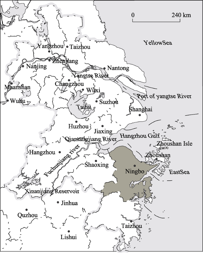
Figure 1 Location of Ningbo city in the Yangtze River Delta
Based on the established database and according to the existing natural, geographic and development conditions, this paper divides the mainland coastline of Ningbo into different coastal segments. The indexes in this paper are selected from the aspects of natural condition, hydrological power, economic development, etc. By means of dominant factor combination, the paper evaluates the suitability of each coastal segment for ecological, production and living functions. The different coastline segments are explained further. The first is the EC which indicates the coastline with great significance for ecological protection, and generally includes the coastline of natural reserves, fishery germplasm resource reserves, important coastal wetlands, etc. The second is the PC, which indicates the coastline of port construction and industrial development. Finally, the LC indicates the coastline of urban and tourism development. By comprehensively overlaying factors such as ecological areas, disaster risks, environmental capacity, water and soil resources, hinterland economic development, and traffic accessibility, the suitability of the coastline for different categories of development or protection can be evaluated, which forms the basis for the proposed divisions of ES, PS and LS of the coastal zone (Figure 2).
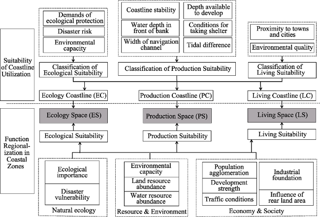
Figure 2 Technical route of spatial function regionalization in coastal zone
This paper, by putting forward the different spatial development and regulations, provides not only a reference for Ningbo to make decisions on a new round of spatial development in the coastal zone and the arrangement of the marine economy but also a scientific basis for related sector plan-making.
Current land use data (in 2015) from Spot5 remote sensing images with 1.5 m resolution is interpreted. The population data is from the Ningbo Statistical Yearbook 2016. The data of important ecological areas, disasters and water environmental capacity are extracted from relevant maps and special planning information. Traffic data is compiled by digitizing the Comprehensive Traffic Planning Chart 2003-2020. The coastline utilization data is collected from sources such as the Master Planning of Ningbo-Zhoushan Port Development, the Marine Function Zoning of Ningbo (2006-2020), and other relevant planning documents.

3 Evaluation of the suitability for coastline utilization

According to the physical geography and actual development conditions, the coastline of Ningbo is divided into 41 coastal segment evaluation units. The determination of evaluation indexes should consider not only the restrictions of ecological protection and environmental capacity but also the supporting functions of natural conditions for developing the marine economy. Furthermore, the relationship between coastline and hinterland, and the harmony among EC, PC and LC should also be given due consideration. The ecological suitability considers factors such as ecological importance, environmental capacity and disaster risk. Ecological importance reflects the importance of maintaining biodiversity, water conservation, and special habitat protection. Disaster risk reflects the possibility of and loss caused by geological disasters. On the other hand, production suitability considers influences on port construction and industrial development, and the relatively stable natural factors such as port navigation conditions. Marine environmental capacity represents the pollutant-carrying capacity of marine water bodies. Port navigation conditions includes coastline stability, water depth in front of seashore, width of navigation-channel water area, depth available to develop in land area, conditions for taking shelter from the wind, and offshore tide, and reflects the natural conditions for the passing through and berthing of ships. Last but not least, living suitability considers indexes such as environmental quality and proximity to towns and cities. Environmental quality represents the comfort of human habitation, while the proximity to towns and cities reflects the availability/accessibility of public services (Figure 3).
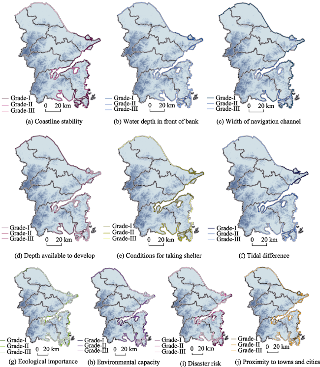
Figure 3 Evaluation indicators of coastline suitability

3.1 Evaluation of the ecological suitability of coastlines

From the perspective of ecological importance, while wetland ecosystem, important fishery categories, and coastal segments reserve are classified as grade-I, scenic tourist areas and tourism resort coastal segments, and other coastal segments are classified under grade-II and grade-III, respectively.
From the perspective of disaster risk, the steeper the topography is, the greater the impact of disaster risk will be. The coastlines with gradient of less than 5°, 5°-15°, and more than 20° are classified under grade-I, grade-II, and grade-III coastlines, respectively.
As shown in the figure of marine environmental capacity, the higher the requirement of target water quality is, the higher the requirements on coastline protection will be. Therefore, the coastline of class-I water area is classified as grade-I, that of class-II water areas is classified as grade-II coastline, and that of class-III and class-IV water areas is regarded as grade-III.
According to a comprehensive analysis based on the three above-mentioned indexes, grade-I ecological suitability coastlines are mainly distributed in the southern part of Xiangshan Bay, in the western part of Xihu Port, and to the side of Hangzhou Bay Bridge. These coastlines are close to important ecological reserves and have relatively lower environmental capacities. Grade-II coastlines are distributed alongside Xiangshan Bay and in the southeastern part of Xiangshan County. Inland from these coastlines, the landform presents substantial terrain relief and has a relatively high risk of geological disaster. The other coastlines have relatively poor ecological suitability (Figure 4a).
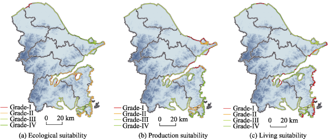
Figure 4 Coastline suitability in Ningbo City

3.2 Evaluation of the production suitability of coastlines

From the perspective of coastline stability, a stable seashore has a stable foundation that is suitable for port development and construction is classified under grade-I of production suitability. On the other hand, while a slow silt-growing coastline is classified under grade-II, a silt-growing coastline has an instable foundation and high development cost and is classified under grade-III.
As shown from the index of the water depth in front of seashore, the coastlines with a -10 m fathom line and a distance of less than 500 m from the seashore have good water depth and are classified as grade-I production suitability, those with a -10 m fathom line and a distance of 500 -1000 m from the seashore are classified under grade-II and those with a -10 m fathom line and a distance of less than 1000 m from the seashore are classified as grade-III.
Based on the index of the width of navigation channel water areas, the coastal segments with navigation channel water areas of 1000 m and above in width are convenient for ships to pass through, berth and turn in, and they should be taken as grade-I, while those with navigation channel water areas of 400-800 m in width should be regarded as grade-II, and those with navigation channel water areas of 400 m or less in width should be regarded as grade-III.
Considering the index of the depth available to develop in rear land area, the coastal segments with rear land area depth of 1000 m and above have good supporting conditions for coastline development, and hence should be classified as grade-I, those with rear land area depth of 500-1000 m should be regarded as grade-II and those with rear land area depth of 500 m and lower should be classified as grade-III.
From the conditions for taking shelter from the wind index perspective, the coastal segments with wave heights of less than 2 m are relatively stable for ships to pass through and should be classified as grade-I, those with wave heights of 2.0-2.5 m should be classified as grade-II, and those with wave heights of higher than 2.5 m should be classified as grade-III.
From the perspective of the index of offshore tide, the coastal segments with tidal range of less than 2.5 m are relatively stable and should be perceived as grade-I, those with tidal range of 2.5-3.5 m should be classified as grade-II and those with tidal range of more than 3.5 m should be regarded as grade-III.
A comprehensive analysis of the abovementioned indexes has shown that the coastlines with grade-I and grade-II production suitability are distributed at the banks of Beilun, Daxie Island, Chuanshan Peninsula, the surrounding areas of Meishan Island, and the gate segments of the Shipu and Xiangshan Ports. The coastal segments of these areas have deep water and relatively good conditions for protection from wind, apart from having spacious rear land area. The grade-III and grade-IV are mainly distributed in the north of the Estuary of Yongjiang River, and the internal areas of Xiangshan Bay, and Sanmen Bay (Figure 4b).

3.3 Evaluation on the living suitability of coastlines

According to the quality of habitable environment, the coastal segments having a distance of less than 1000 m, 1000-2000 m, and more than 2000 m from ecological function areas and scenic areas are regarded as grade-I, grade-II, and grade-III living suitability, respectively.
Based on the index of proximity to nearby towns and cities, the coastal segments having a distance of less than 1000 m, 1000-2000 m, and more than 2000 m from adjacent towns and cities should be taken as grade-I, grade-II, and grade-III living suitability, respectively.
A comprehensive consideration of the above-mentioned indexes shows that the coastlines with the grade-I and grade-II living suitability are mainly distributed along the southern part of Xiangshan Bay, in the southeast of Xiangshan County, and in the northwest of Meishan Island. The areas adjacent to these coastlines are close to mountains and rivers and have convenient traffic conditions. The coastlines of other areas have relatively poor living suitability and are mostly regarded as grade-III and grade-IV living suitability (Figure 4c).

3.4 Comprehensive evaluation

Based on the classification of evaluation, this paper compares three grades of each coastal segment and assesses the comprehensive suitability type by combining the current development state. Generally, ECs are distributed in the southern part of Xiangshan Port, in the western part of Xihu Port, in the middle part of the South Bank of Hangzhou Bay, etc., and they maintain the current state and original habitat. PCs are distributed in Zhenhai, Beilun, Daxie, and Meishan islands; the Gate Segment of Xiangshan; and the Shipu Ports. LCs are concentrated in the northwest of Meishan Island, at the bottom of Xiangshan Port, and in the southeast of Xiangshan County (Table 1).
Table 1 The coastline suitability based on analysis of ecology, production and living suitability
Coastal segment Length(km) Suitability grade Function
type
Production Living Ecology
Shaoning Boundary - Jiantang River Gate 23.6 EC
Jiantang River Gate - 500 m upstream of Hangzhou Bay Bridge 10.0 IV EC
500 m upstream of Hangzhou Bay Bridge - Fourth Xingci Road 11.0 LC
Fourth Xingci Road - Hudun Mountain 60.0 IV EC
Hudun Mountain - North bank of Yongjiang River Estuary 2.2 IV PC
South bank of Yongjiang River Estuary - Suanshanqi 6.6 IV PC
Suanshanqi - Puxia 10.0 IV PC
Puxia - 100 m to the west of Daxie Bridge 3.3 IV PC
100 m to the west of Daxie Bridge - East of Yanting Village, Baifeng Town 8.1 IV PC
West edge of Waizhi Island - East edge of Waizhi Island 5.2 IV EC
East edge of Waizhi Island - Jiuwan Village 3.3 IV PC
Jiuwan Village - Banyuepu 8.3 PC
100 m to the west of Daxie Bridge - Tuni Mountain 8.9 IV PC
Tuni Mountain - Fuzhu Village 5.7 IV PC
Fuzhu Village - 100 m in the east of Daxie Bridge 7.9 IV PC
West edge of Lishenma Island - East edge of Lishenma Island 2.9 IV PC
West edge of Waishenma Island - East edge of Waishenma Island 3.4 PC
West edge of Chuanbi Island - East edge of Chuanbi Island 5.8 PC
Banyuepu - Xiaoao 10.1 LC
Xiaoao - Haikou 8.1 PC
Haikou - Guantou Mountain 4.6 IV PC
Meishan Village - Xiazhitou 9.0 IV PC
Xiazhitou - Chuangyeqi 3.7 EC
Chuangyeqi - Phoenix Mountain 8.1 LC
Shizikou - Ganao Village 8.5 LC
Xiaogan’ao - Yangsha Mountain 8.1 LC
Yangsha Mountain - Linjiang Bridge 9.3 EC
Linjiang Bridge - 500 m at the east side of Xiangshan Bay Bridge 6.6 IV IV PC
500 m at the West side of Xiangshan Bay Bridge - Dalie Mountain 8.6 IV IV PC
Dalie Mountain - Shizitou 2.5 LC
Shizitou - Huangyantou 2.8 IV PC
Hengjiang River Gate - Huangni’ao 5.0 EC
Huangni’ao - Xianren Shizi Mountain 5.8 LC
Xianren Shizi Mountain - Dongchili 1.9 IV PC
Dongchili - Xifeng Center 5.0 EC
Xifeng Center - Shuangshan Mountain 4.2 EC
Shuangshan Mountain - Dong’ao 6.2 IV EC
Dong’ao - Shuangshan Mountain 1.9 LC
Shuangshan Mountain - Sanxin Plastic Products Co. 2.3 IV EC
Sanxin Plastic Products Co., Ltd. - Haitang Road 2.3 LC
Haitang Road - Xiachenjia Village 6.3 EC

4 Method for function regionalization in coastal zones

This evaluation of spatial function regionalization of the coastal zone uses a 1 km2 grid as the evaluation unit, and covers a total of 3379 grid units in the case study coastal zone (5 km from coastline to land area). First, the coastline condition is taken as the main factor influencing the spatial development of coastal zone. In principle, the ecology, production and living suitability of coastal zone are in accordance with that of front coastline. On this basis, the indexes such as natural ecology, resource environment, and economics are selected for comprehensive evaluation. As the indicators for the development of different spaces of a coastal zone are different, it is necessary to evaluate the suitability of different indicators for different spaces, such as ecology, production, and living, through index combination methods and their functional directions (Table 2 and Figure 5).
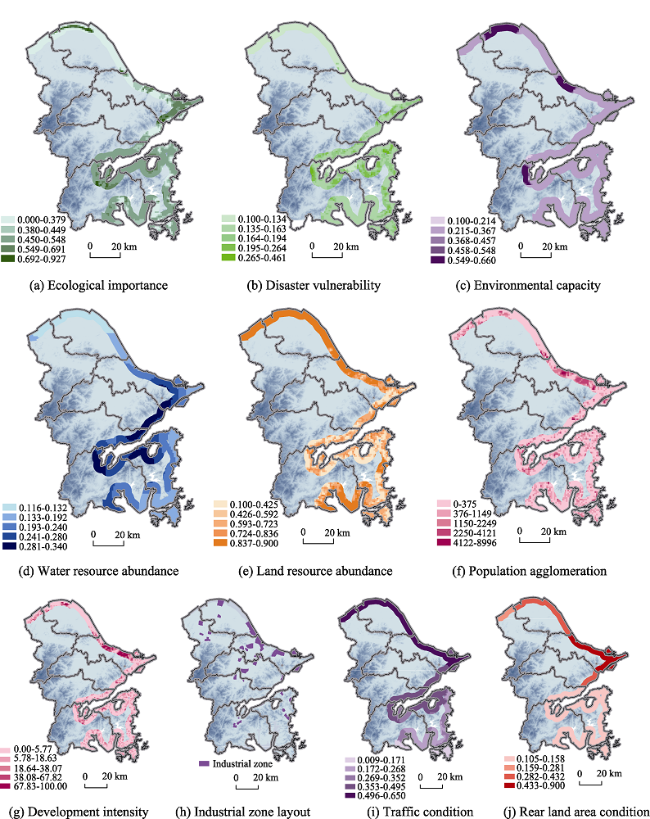
Table 2 Evaluation index system of spatial function regionalization
Elements Index items
Natural ecology Ecological importance Natural reserve
Water head site and conservation area
Forest park
Mountain land
Class-I and Class-II marine influencing areas
Disaster vulnerability Paroxysmal geological hazards
Slow ground settlement
Resource &
environment
Environmental capacity Surface water environmental capacity
Atmospheric environmental capacity
Land resource abundance Quantity: Proportion of land resources available
Quality: Soil suitable for agriculture (paddy soil distribution)
Water resource abundance Mean annual precipitation in 1956-2000
Economy & society Population agglomeration Population density
Development strength Proportion of construction land among the area of grid units
Traffic conditions Time distance to Ningbo city center, main ports, and main traffic nodes
Industrial foundation Distribution of national and provincial development zones and key parks
Influence of rear land area Population density, urbanization level, completed area scale, and per capita GDP of the county territory
Figure 5 Evaluation indicators of spatial function regionalization in the coastal zone
Second, weights embody each index’s importance and influence on the goal of evaluation. The determination of weight should sufficiently embody the differential characteristics and inherent differences of regional resource conditions and economic development. Here, recoverability and substitutability should be mainly considered for the natural ecological element, while guidance quality should be considered for the socio-economic elements. The indexes having relatively great influences on the socio-economic development and ecological protection should be endowed with a relatively higher weight, while those indexes which are not as stable, or could be changed through engineering technical conditions should be endowed with a relatively lower weight. Weights are determined by a combination of sub-jective and objective analyses, where subjective weights are analyzed with an analytical hi-erarchy process, and objective weights are mainly obtained by an entropy evaluation method.
The suitability evaluation of ES should not only highlight the importance of natural ecology and resource environment indexes but also consider the influence of existing development pattern. Natural ecology and resource environment indexes exert guiding functions, while the current development index exerts a restrictive function. The evaluation of the suitability of PS should consider comprehensively the bearing capacity of resource and environment, to the restriction of natural ecology, and to the development foundation of existing economic society. Resource environment and economic society indexes exert guiding functions, while natural ecology indexes exert restrictive functions. However, due to mutual occupation of small-scale PS and LS, the population agglomeration index of socio-economy is a restrictive index. The regionalization of LS suitability mainly reflects the advantages and disadvantages of human habitat conditions, whereas the natural ecology index is mainly taken as a restrictive index. However, as it reflects whether the areas surrounding important ecological function areas, mountain lands, etc. have good ecological environment and are suitable for human habitat, the natural ecology index may also be taken as a guiding index. While resource environment and socio-economic indexes mainly exert guiding functions on population layout, but in small-scale evaluation, industrial foundation is a restrictive index for population distribution (Table 3).
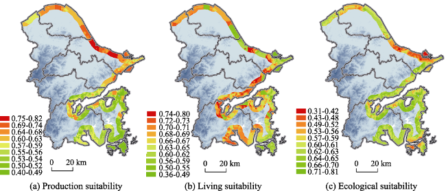
Table 3 The selection of indicators and weight about different spatial evaluations
Influential elements Ecological suitability Production suitability Living suitability
Coastline
suitability
EC Guiding (0.30) Restrictive (0.10) Restrictive (0.10)
PC Restrictive (0.10) Guiding (0.30) Restrictive (0.10)
LC Restrictive (0.10) Restrictive (0.10) Guiding (0.30)
Natural ecology Ecological importance Guiding (0.13) Restrictive (0.09) Restrictive (0.09)
Disaster vulnerability Guiding (0.09) Restrictive (0.03) Restrictive (0.03)
Resource &
environment
Environmental capacity Guiding (0.08) Guiding (0.09) Guiding (0.03)
Water resource
abundance
- Guiding (0.06) Guiding (0.09)
Land resource abundance - Guiding (0.06) Guiding (0.06)
Economy & society Population agglomeration Restrictive (0.08) Restrictive (0.03) Guiding (0.03)
Traffic condition - Guiding (0.03) Guiding (0.03)
Development intensity Restrictive (0.07) - -
Industrial foundation Restrictive (0.05) Guiding (0.06) Restrictive (0.12)
Hinterland influence - Guiding (0.06) Guiding (0.03)
After stepwise hierarchically merging the above-mentioned indexes, parallel and independent indexes are standardized (according to formula 1). Then, the index value is converted into dimensionless numerical value between [0, 1]. Finally, through a weighted sum (based on formula 2), we may obtain the ecology, production and living suitability indexes of each evaluation unit.
$X=\frac{{x}'-{{{{x}'}}_{\min }}}{{{{{x}'}}_{\max }}-{{{{x}'}}_{\min }}}$ (1)
${{A}_{i}}=\sum\limits_{j=1}^{n}{{{X}_{ij}}\times {{W}_{j}}}$ (2)
where X indicates the normalized value, ${x}'$ indicates the value of the element,${{{x}'}_{\max }}$indicates the maximum value of the element, and ${{{x}'}_{\min }}$ indicates the minimum value of the element; Ai indicates the ecology, production or living suitability index of unit i; Xij indicates the value of element j of unit i; and Wj indicates the weight of the value of element j.
The evaluation results show that the areas with relatively good ecological suitability are concentrated at the west end of Xiangshan Port, Damuyang, and Sanmen Bay. These areas basically belong to low-mountain and hilly areas and have relatively small environmental capacity. Beilun, Zhenhai, Meishan, etc., with relatively high development level at present, have relatively low suitability for layout of ecological spaces. The areas with relatively good production suitability are concentrated at Beilun and Zhenhai. In addition, Hangzhou Bay New Town and Shipu Port have relatively high production suitability. These areas are highly developed and are major locations of industrial zones. The local places at Xiangshan Port, Damuyang, and the west of Sanmen Bay have relatively low production suitability. The areas with relatively good living suitability are concentrated at Chuanshan Peninsula, Xiangshan Port, and partial areas at the south bank of Hangzhou Bay. These areas are highly developed at present, closer to mountain areas and have good habitable environment. Zhenhai Chemical Zone, Cidong Shoal Area, Daxie Island, Meishan Island, etc. are industrial development zones or important ecological function areas and are not suitable for large-scale population agglomeration (Figure 6).
Figure 6 Evaluation result of spatial function regionalization in the coastal zone

5 Conclusion and discussion

Through a suitability evaluation of coastline utilization and function regionalization of the coastal zone, the coastal territory may be divided into ES, PS and LS. Different control and regulation approaches may be implemented for the different types of zones. The requirements on the control of 41 coastal segments in Ningbo city may be further defined, such as the key development area, the development intensity, and environmental protection. In general, the areas suitable for production spaces in the coastal zone of Ningbo are mainly located at the south bank of Hangzhou Bay, in Cidong, and Beilun-Zhenhai. The living spaces are mainly distributed in the New Town at the south bank of Hangzhou Bay, the Beilun Urban Area, and the partial urban areas inside the Xiangshan Port, Shipu, and the New Town in the East of Xiangshan. Ecological spaces are mainly the natural reserves, forest areas, hilly areas and mountain lands, water conservation areas, important shoals, etc. It is worth mentioning that higher development intensity shall be strictly controlled for areas inside Xiangshan Port and the areas close to the marine space of Sanmen Bay in Ninghai and Xiangshan. These areas, as ecological protection areas and reserves, should not be developed before the conditions become mature.
Generally, the suitability of coastline utilization and the function regionalization of coastal zone methods basically meet the natural conditions of the spatial development of coastal zone in Ningbo. This provides a scientific basis for promoting sustainable development of the marine economy and the reasonable utilization of coastline and spatial resources in the coastal zone. The outcomes of this paper are not only beneficial for coordinating spatial development and ecological environmental protection in coastal zones, but they also have certain guiding significance for Ningbo’s reasonable and orderly layout of the marine economy in the future. In particular, the differential guidance of spatial development could encourage large-scale and high-intensity development in the areas that have relatively few ecological restrictions and vigorous development demand and thereby lower the development intensity of the areas with more sensitive ecological environments and allow them to mainly undertake the function of regional ecological maintenance. On one hand, it could enhance the level of land resource savings and intensive utilization, and lessen the restriction of land resources. On the other hand, it could reasonably protect the ecological environment of marine spaces, mountain lands and hilly areas, maintain the stable structure and function of regional ecological systems, and achieve sustainable development.
From the perspective of regionalization methods, the key to the validity of regionalization results rests with index selection and data reliability. In this paper, for the suitability evaluation of coastline utilization, some port navigation data, hydrological data, and underwater topography data were obtained from secondary sources by interpreting related data and sorting out related research reports. This paper did not use first-hand data, and this limitation should be further complemented and improved in future studies. On the other hand, the utilization of space in the coastal zone is affected by the selection of development mode for the hinterland and by factors at a wider spatial scale. Herein, the study area was considered as a closed space. Thus, this concept will be applied at a wider scale for function regionalization. Additionally, how to integrate the evaluation of ES, PS and LS and show the result on one map, and how to determine the reasonable proportion of coastline utilization and the spatial structure in different coastal zones, all of these need deep research in the future.

The authors have declared that no competing interests exist.

1
Ajith J K, 2016. Concepts and policies of Integrated Coastal Zone Management (ICZM). In: Training Programme on Geomatics for Coastal Zone Management, April 18-22.

2
Altunkaynak A, 2015. Prediction of significant wave height using spatial function.Ocean Engineering, 106: 220-226.61A novel approach was used to predict significant wave height by spatial function.61Spatial function can be used for estimating missing and unmeasured data.61This method is developed using a data set of 22 wave measurement stations.61The method was compared with two classical geostatistical approaches.

DOI

3
Armstrong J M, Ryner P C, 1986. American Ocean Management. Beijing: China Ocean Press.

4
Bradley J R, Wikle C K, Holan S H, 2016. Regionalization of multiscale spatial processes by using a criterion for spatial aggregation error.Journal of the Royal Statistical Society, 79(3): 815-832.Summary The modifiable areal unit problem and the ecological fallacy are known problems that occur when modelling multiscale spatial processes. We investigate how these forms of spatial aggregation error can guide a regionalization over a spatial domain of interest. By ‘regionalization’ we mean a specification of geographies that define the spatial support for areal data. This topic has been studied vigorously by geographers but has been given less attention by spatial statisticians. Thus, we propose a criterion for spatial aggregation error, which we minimize to obtain an optimal regionalization. To define the criterion we draw a connection between spatial aggregation error and a new multiscale representation of the Karhunen–Loève expansion. This relationship between the criterion for spatial aggregation error and the multiscale Karhunen–Loève expansion leads to illuminating theoretical developments including connections between spatial aggregation error, squared prediction error, spatial variance and a novel extension of Obled–Creutin eigenfunctions. The effectiveness of our approach is demonstrated through an analysis of two data sets: one using the American Community Survey and one related to environmental ocean winds.

DOI

5
Bronfenbrenner U E, 2004. Making Human Beings Human: Bioecological Perspectives on Human Development. The SAGE Program on Applied Developmental Science. Sage Publications, 336.To a greater extent than any other species, human beings create the environments that, in turn, shape their own development. This book endeavors to demonstrate that human beings can also develop those environments to optimize their most constructive genetic potentials. What makes human beings human, therefore, is both the potential to shape their world in intricate physical, social, technological, and cultural ways and the possibility that these actions will nurture positive development. The collection of articles traces and summarizes the editor's thoughts on the bioecological theory of human development and recommends avenues for future research, documenting the domain of inquiry that has emerged gradually over many years. The book is targeted to developmental psychologists, educators, and public policy individuals involved with families and education, and is also a text for courses in Psychology, Family Studies and Human Development, Human Ecology, Education, and Public Policy.

6
Chen W, 2008. Economic Analysis on Space Equilibrium. Beijing: The Commercial Press. (in Chinese)

7
Domínguez-Tejo E, Metternicht G, Johnston E et al. 2016. Marine spatial planning advancing the ecosystem-based approach to coastal zone management: A review.Marine Policy, 72: 115-130.61Design, conceptual and methodological differences were observed in applying the EBA in MSP.61MSP could benefit from social sciences approaches and development of social objectives.61Non-market and cultural/heritage values were poorly represented in comparison to economic and environmental values.61Few cases reviewed catchment plans, with emphasis on identification of cross-realm threats and impacts.

DOI

8
Dreizis Y I, 2015. Integrated coastal zone management is the main mechanism for sustainable development of the sea region.Modeling of Artificial Intelligence, 5(1): 4-8.

DOI

9
Duck R W, 2012. Marine spatial planning: Managing a dynamic environment.Journal of Environmental Policy and Planning, 14(1): 67-79.From both the sedimentological and the geomorphological perspective, the underlying premise that marine spatial planning should closely complement and integrate with terrestrial spatial planning, river basin and coastal zone management planning systems might superficially appear sensible, but it is inherently problematic. The degree of dynamism and dynamic variability in the terrestrial environment, that is, at the earth surface tmosphere interface, is in no way comparable in magnitude or frequency with that experienced at the water ediment interface of the often highly mobile sea bed or within the overlying water column itself. Moreover, the hydrodynamic marine processes involved, such as bedload and suspended sediment transport, are fundamentally different from subaerial processes, thereby leading to challenges in integrating onshore and offshore planning systems. This essential process-based distinction leads to the suggestion, which is explored in this article, that marine spatial planning should be underpinned by some form of process-defined planning unit that is determined in scale by the nature of the intended development. In this regard, it is proposed that the flexible Process-Defined Management Unit approach, which has been introduced recently as an aid to sustainable coastal decision-making and to improve upon previous coastal zone management unit approaches, provides a basis that responds to difficulties already being recognized within marine spatial planning.

DOI

10
Fan J, 2007. Scientific foundation of principal function regionalization in China. Acta Geographica Sinica, 62(4): 339-350. (in Chinese)

11
Gleason M, Mccreary S, Miller-Henson M et al. 2010. Science-based and stakeholder-driven marine protected area network planning: A successful case study from North Central California.Ocean and Coastal Management, 53(2): 52-68.The planning process for California's Marine Life Protection Act in north central California represents a case study in the design of a regional component of a statewide network of marine protected areas (MPAs) for improved ecosystem protection. We describe enabling factors, such as a legislative mandate, political will, and adequate capacity and funding that fostered a successful planning process. We identify strategic principles that guided the design of a transparent public planning process that delivered regional MPA network proposals, which both met science guidelines and achieved a high level of support among stakeholders. We also describe key decision support elements (spatial data, planning tools, and scientific evaluation) that were essential for designing, evaluating, and refining alternative MPA network proposals and for informing decision-makers.

DOI

12
Goble B J, Lewis M, Hill T Ret al., 2014. Coastal management in South Africa: Historical perspectives and setting the stage of a new era.Ocean and Coastal Management, 91: 32-40.61Consideration as to global coastal management status and trends.61Assessment of historical coastal management in South Africa, a developing country with a diverse socio-economic history.61Overview of the development of new Coastal management legislation for South Africa.61Identification of potential implementation hurdles of new coastal management legislation for South Africa.

DOI

13
Grantham H S, Mcleod E, Brooks A et al. 2011. Ecosystem-based adaptation in marine ecosystems of tropical Oceania in response to climate change.Pacific Conservation Biology, 17(3): 241-258.Tropical Oceania, including Melanesia, Polynesia, Micronesia and northern Australia, is one of the most biodiverse regions of the world. Climate change impacts have already occurred in the region and will become one of the greatest threats to biodiversity and people. Climate projections indicate that sea levels will rise in many places but not uniformly. Islands will warm and annual rainfall will increase and exhibit strong decadal variations. Increases in global atmospheric CO2 concentration are causing ocean acidification, compromising the ability of organisms such as corals to maintain their calcium carbonate skeletons. We discuss these climate threats and their implications for the biodiversity of several ecosystems (coral reefs, seagrass and mangroves) in the region. We highlight current adaptation approaches designed to address these threats, including efforts to integrate ecosystem and community-based approaches. Finally, we identify guiding principles for developing effective ecosystem-based adaptation strategies. Despite broad differences in governance and social systems within the region, particularly between Australia and the rest of the Pacific, threats and planning objectives are similar. Ensuring community awareness and participation are essential everywhere. The science underpinning ecosystem-based adaptation strategies is in its infancy but there is great opportunity for communicating approaches and lessons learnt between developing and developed nations in tropical Oceania.

DOI

14
Gu C L, Zhang X M, Liu J Y et al. 2007. The development space regionalization of Yancheng and the deliberation on it.Acta Geographica Sinica, 62(8): 787-798. (in Chinese)

15
Huang J C, Lin H X, Qi X X, 2017. Spatial development regionalization of the Beijing-Tianjin-Hebei Region from the perspective of spatial governance.Progress in Geography, 36(1): 46-57. (in Chinese)京津冀协同发展的核心是基于问题导向和底线思维,打破行政区划,在更大区域尺度上优化资源配置,实现区域整体发展目标。因此,从优化空间规划体系的高度,开展京津冀区域协同发展的类型区划和类型区管理,实现分区施策的精细化管治极为重要。本文首先立足于京津冀区域发展差异,利用空间属性双聚类的方法将京津冀划分为中部核心功能引领区、东部沿海重点发展区、南部门户功能拓展区、西部和北部生态涵养保护区等四大区域;然后以区县为最小分析单元,从现状开发强度、用地增量预测和生态保护责任等三大维度构建类型划分指标体系,并利用三维空间坐标划分方法将京津冀划分为五大类型区,即:城镇优化发展区、城镇重点拓展区、现代农业发展区、适度建设发展区和严格生态保护区;最后,在空间管治视角下提出京津冀区域分区管治与区域协同管理的建议。

DOI

16
Liang X B, 2005. Research on the method for marine function regionalization and its application [D]. Tianjin: Tianjin Normal University. (in Chinese)

17
Marre J B, Thebaud O, Pascoe S et al. 2015. The use of ecosystem services valuation in Australian coastal zone management.Marine Policy, 56: 117-124.The use and influence of ecosystem services valuation in management decision-making, particularly as it relates to coastal zone management, remains largely unexplored in the academic literature. A recent Australia-wide survey of decision-makers involved in coastal zone management examined if, how and to what extent economic valuation of coastal and marine ecosystem services is used in, and influences, decision-making in Australia. The survey also identified a set of cases where economic valuation of ecosystem services was used for decision-making, and reasons why economic values may or may not be considered in the decision-making process. This paper details the method and results from this survey. Overall, there is strong empirical evidence that economic valuation of ecosystem services is used, but with important variation across coastal and marine management contexts. However, the impact of ecosystem services valuation on policy appears to be globally weak.

DOI

18
McGlashan D J, Duck R W, 2013. The PDMU approach to the integration of coastal management.Journal of Coastal Research, 26(3): 465-469.The context underlying the concept of Process-Defined Management Units (PDMUs) as an aid to sustainable coastal decision-making is reviewed. Using examples, it is suggested that the flexible PDMU approach can help to pragmatically integrate coastal management and has considerable merits compared with other types of coastal management units, such as sediment cells and Homogeneous Environmental Management Units (HEMUs).

DOI

19
Najafinasab F, Karbassi A R, Ghoddousi J, 2015. Fuzzy analytic network process approach to evaluate land and sea criteria for land use planning in coastal areas.Ocean and Coastal Management, 116: 368-381.61For the first time DEMATEL and ANP methods with fuzzy logic have been used for land use planning.61Criteria were selected from “land” and “sea” for land-use planning in coastal areas.61Sea oriented criteria are of equal importance to the land criteria.61Our integrated framework can guide policy makers toward enhancing sustainability in coastal areas.

DOI

20
Ramessur R T, 2015. Integrated coastal zone management: Ecological, socio-economic and governance challenges.Journal of Coastal Zone Management, 18: 2. doi: 10.4172/2473-3350.1000e112

21
Ramsey V, Cooper J A G, Yates K L, 2015. Integrated coastal zone management and its potential application to Antigua and Barbuda.Ocean and Coastal Management, 118: 259-274.61We offer a review of the current coastal management situation in Antigua and Barbuda.61We explore local stakeholder perceptions of Integrated Coastal Zone Management (ICZM).61We investigate local stakeholder priorities for ICZM.61We identify best practices of Small Island Developing States to inform the process of ICZM.61A detailed implementation process for ICZM in small island states is proposed.

DOI

22
Santoso P B, Halog A, 2017. Science based modelling for supporting integrated coastal zone management. In: Environmental Modeling with Stakeholders. Springer International Publishing, 307-325.Approach: A systematic review of the integrated coastal zone management (ICZM) approach and all related tools for science-based modeling is undertaken.

DOI

23
State Oceanic Administration (SOA), 2017. Bulletin of China Marine Economic Statistics. . 2017-03-30.

24
Sun W, 2010. Research on the admittance and collocation of elements for spatial function regionalization and governance in urban areas: A case study of Wuxi [D]. Beijing: Graduate University of the Chinese Academy of Sciences. (in Chinese)

25
Sun W, 2013. The Theory, Methods and Applications of Spatial Function Regionalization. Beijing: Science Press. (in Chinese)

26
Sun W, Chen W, 2009. Research on urban space development suitability regionalization and layout guide: A case study in Ningbo City.Journal of Natural Resources, 24(3): 402-413. (in Chinese)

Outlines

/