研究论文

Spatiotemporal patterns in urbanization efficiency within the Yangtze River Economic Belt between 2005 and 2014

  • JIN Gui , 1, 2, 3 ,
  • DENG Xiangzheng 2 ,
  • ZHAO Xiaodong 1, 4 ,
  • GUO Baishu , 1, 3, * ,
  • YANG Jun 5
Expand
  • 1. Faculty of Resources and Environmental Science, Hubei University, Wuhan 430062, China
  • 2. Institute of Geographic Sciences and Natural Resources Research, CAS, Beijing 100101, China
  • 3. Center for National Land Space Management, Hubei University, Wuhan 430062, China
  • 4. Hubei Province Key Laboratory of Regional Development and Environmental Response, Wuhan 430062, China
  • 5. School of Geographic and Oceanographic Sciences, Nanjing University, Nanjing 210023, China
*Corresponding author: Guo Baishu, E-mail:

Author: Jin Gui (1986-), Associate Professor, specialized in land resources evaluation and land management. E-mail:

Received date: 2018-01-18

  Accepted date: 2018-02-28

  Online published: 2018-08-10

Supported by

National Natural Science Foundation of China, No.41501593, No.41601592;National Program on Key Research Project, No.2016YFA0602500

Copyright

Journal of Geographical Sciences, All Rights Reserved

Abstract

The question of how to generate maximum socio-economic benefits while at the same time minimizing input from urban land resources lies at the core of regional ecological civilization construction. We apply stochastic frontier analysis (SFA) in this study to municipal input-output data for the period between 2005 and 2014 to evaluate the urbanization efficiency of 110 cities within the Yangtze River Economic Belt (YREB) and then further assess the spatial association characteristics of these values. The results of this study initially reveal that the urbanization efficiency of the YREB increased from 0.34 to 0.53 between 2005 and 2014, a significant growth at a cumulative rate of 54.07%. Data show that the efficiency growth rate of cities within the upper reaches of the Yangtze River has been faster than that of their counterparts in the middle and lower reaches, and that there is also a great deal of additional potential for growth in urbanization efficiency across the whole area. Secondly, results show that urbanization efficiency conforms to a “bar-like” distribution across the whole area, gradually decreasing from the east to the west. This trend highlights great intra-provincial differences, but also striking inter-provincial variation within the upper, middle, and lower reaches of the Yangtze River. The total urbanization efficiency of cities within the lower reaches of the river has been the highest, followed successively by those within the middle and upper reaches. Finally, values for Moran’s I within this area remained higher than zero over the study period and have increased annually; this result indicates a positive spatial correlation between the urbanization efficiency of cities and annual increments in agglomeration level. Our use of the local indicators of spatial association (LISA) statistic has enabled us to quantify characteristics of “small agglomeration and large dispersion”. Thus, “high- high” (H-H) agglomeration areas can be seen to have spread outwards from around Zhejiang Province and the city of Shanghai, while areas characterized by “low-low” (L-L) patterns are mainly concentrated in the north of Anhui Province and in Sichuan Province. The framework and results of this research are of considerable significance to our understanding of both land use sustainability and balanced development.

Cite this article

JIN Gui , DENG Xiangzheng , ZHAO Xiaodong , GUO Baishu , YANG Jun . Spatiotemporal patterns in urbanization efficiency within the Yangtze River Economic Belt between 2005 and 2014[J]. Journal of Geographical Sciences, 2018 , 28(8) : 1113 -1126 . DOI: 10.1007/s11442-018-1545-2

1 Introduction

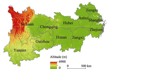
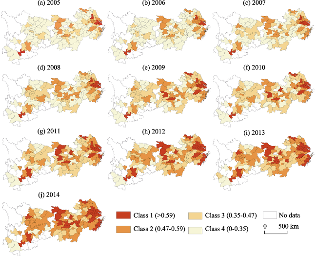
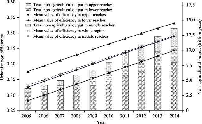
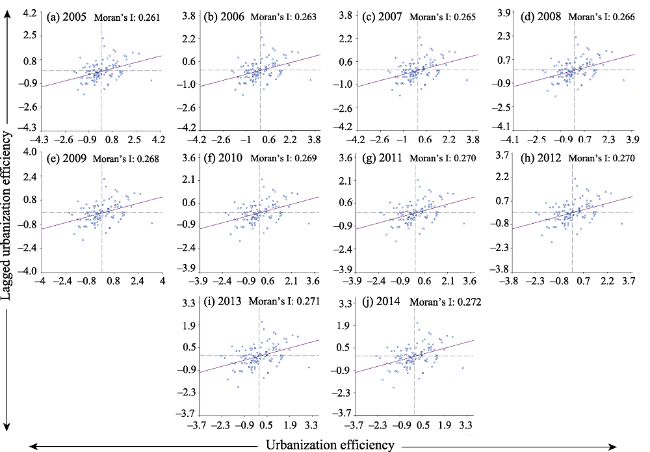
China has experienced a period of rapid urbanization over recent decades. The ever-increasing area of urban construction land nationally has consumed other kinds of territory (e.g., cultivated and forested land) and has led to enhanced and marked contradictions between the development of built-up areas, the protection of farmland, and ecological conservation (Zuo et al., 2014; Fang et al., 2017). Extensive urban land-use patterns within cities and towns lead to problems in territorial development including the irrational structuring of construction land as well as the scattered spatial distribution and low efficiency of land use (Fu et al., 2014). As China has both a finite land area and a massive population, improving the efficiency of urbanization has become a critical requirement for promoting both regional sustainable development and national ecological civilization (Li et al., 2015). Key documents published by the Chinese government in recent years have noted that inefficient and disorderly urban land use needs to be urgently managed; thus, the “13th Five-year Plan for Land and Resources” (2016-2020) explicitly proposed the use of double-control measures to control both the quantity and intensity of land use as well as to strengthen controls on the utilization of construction land (Jin et al., 2015). As a result of rapid urbanization, the question of how to obtain maximum socio-economic benefits with minimum input has gradually developed to become the focus of scientific research and national strategic decision-making. A great deal of recent research on urbanization efficiency is available, concerning multiple spatial scales and utilizing a range of methodologies. Most studies have emphasized the issue of land use efficiency from different perspectives, including the efficiency of construction land and farmland productivity. Associations between land use and urbanization efficiency have also been analyzed (Huang et al., 2016; Nguyen et al., 2017; Deilmann et al., 2018) at all spatial scales (e.g., national and provincial as well as at the level of urban agglomerations, watersheds and individual cities) (Wang et al., 2014; Rashidi et al., 2015). Previous research has also highlighted the mechanisms underlying changes in urbanization efficiency by analyzing drivers and spillover effects at different spatial scales (Wang et al., 2015); thus, both parametric and non-parametric methods have been utilized in this area (Battese et al., 1995; Jin et al., 2017), corresponding with the classic data envelopment analysis (DEA) and stochastic frontier analysis (SFA) models, respectively. The first of these two approaches employs the linear programming mathematical process to evaluate the relative efficiency of a decision-making unit within a fixed production frontier, while the latter uses a production function to accurately simulate the absolute efficiency of an object being evaluated while at the same time taking the impact of uncontrollable factors influencing efficiency into account. The latter approach has proven to be more pertinent than the former in the case of certain problems (Ghosh et al., 2016; Jin et al., 2017). Thus, in general, although the SFA model has been widely applied in technical efficiency calculations involving domestic and foreign economic or enterprise production activities, few empirical studies addressing land use, urbanization, and ecological efficiency within China have so far been performed (Li et al., 2017; Jia et al., 2017). Current results have also normally been analyzed from economic or management perspectives in order to elaborate on the nature of this phenomenon and to understand underlying mechanisms. An extremely limited number of time-series expressions that encapsulate efficient geospatial morphologies have therefore been undertaken.
The SFA model is introduced in this study alongside a spatial correlation approach to urban studies in order to emphasize urbanization efficiency from the joint perspectives of avoiding uncontrollable factors and inefficiencies in calculations as well as to achieve an appropriate geospatial morphological representation. The urbanization efficiencies of 110 cities within the Yangtze River Economic Belt (YREB) between 2005 and 2014 were therefore calculated and further analyzed in this study in order to enrich available case studies, highlight the spatiotemporal evolution and spatial morphological characteristics of these agglomerations, and to provide additional reference data for optimal land allocation in the context of balanced regional development.

2 Study area

The YREB spans three major regions of China (i.e., Eastern China, Central China, and Western China) and includes nine provinces (i.e., Jiangsu, Zhejiang, Anhui, Jiangxi, Hubei, Hunan, Sichuan, Yunnan, and Guizhou) and two municipalities (i.e., Shanghai and Chongqing) (Figure 1). Thus, as the YREB encapsulates a total area of approximately 2,050,000 km2 and includes a population and gross domestic product (GDP) in excess of 40% of the whole country, this region comprises one of the most important strategic support areas nationally. On the basis of differences in socioeconomic development between regions and large variations in natural resources, the YREB is usually divided into three areas that correspond with the upper, middle, and lower reaches of the river basin. The first of these areas includes 33 cities within Guizhou, Yunnan, and Sichuan provinces as well as the municipality of Chongqing, while the middle reaches encapsulates 36 cities within Hunan, Hubei and Jiangxi provinces. The lower reaches of the YREB includes 41 cities within Anhui, Zhejiang, and Jiangsu provinces as well as the municipality of Shanghai. The overall area of the YREB also includes three major urban agglomerations within the Yangtze River Delta urban agglomeration (i.e., urban agglomerations within the middle reaches of the Yangtze River, the Cheng-Yu urban agglomerations and regional urban agglomerations including the Wanjiang urban belt as well as the central Guizhou and central Yunnan urban agglomerations). The “13th Five-year Plan for Economic and Social Development of the People’s Republic of China” (2016-2020) has identified YREB policy as one of three major regional development strategies nationally; development within this region is intended to engender an ecological civilization demonstration zone based on advanced ideas with global influence. However, because of the rapid development of urbanization within China, contradictions between ecological preservation, urbanization, and the protection of farmland within the YREB have become increasingly marked. The use of large areas of farmland and ecological land for construction has had a particularly marked negative impact on resources and the environment; coupled with the inefficient utilization of urban land resources, this phenomenon has, to a large extent, restricted regional sustainable development. The YREB is therefore considered in this study as a typical case study region to explore the laws of urbanization efficiency and their spatial differentiation, as well as to provide a scientific basis for the future construction of regional ecological civilization and land-use optimization.
Figure 1 A general overview of the YREB

3 Data and methods

3.1 Data sources and processing

Urban construction land, capital stock, and non-agricultural labor were chosen as the input indicators used in this analysis, while non-agricultural output was utilized to comprehensively reflect the level of urban economic development. The use of these variables is based on the classic production functions of labor, capital, and land as three basic input indicators alongside economic output. The use of these indicators is appropriate based on an understanding of urban land use characteristics such that specific variables should adequately reflect the characteristics of non-agricultural production activities (Wang et al., 2015; Deilmann et al., 2016; Chen et al., 2016).
Socio-economic data was used as the basis of a SFA model implemented to measure efficiency (Shabani et al., 2015; Yang et al., 2016). Thus, relevant land, capital, and labor force data were extracted for this study from China’s Urban Statistical Yearbook (2005-2014), the China’s Regional Economic Statistical Yearbook (2005-2014), and the Provincial (Municipalities) Statistical Yearbook (2005-2014), alongside consumer price index (CPI) data provided by the National Bureau of Statistics. Urban non-agricultural output was estimated on a yearly basis using the GDP deflator based on statistical yearbook data, while urban construction land was defined as the sum of this land use type within a city and surrounding suburbs. Our use of capital refers to fiscal expenditure and capital stock; the first of these variables was reduced at the beginning of the study period using the CPI, while capital stock was estimated by adopting the perpetual inventory method (PIM). This approach involves the selection of current investment indicators, a yearly capital stock calculation, the selection of a depreciation rate, and an investment calculation (Guan et al., 2015; Lin et al., 2017). Our use of the concept of labor force refers to non-agricultural workforce, a unit encompassing practitioners, private, and individual employees. All YREB data were organized into city-level panels encompassing the period between 2005 and 2014.

3.2 Methods

3.2.1 SFA model
The SFA method was proposed in the same year by Aigner et al. (1977) and Meeusen et al. (1977) and is considered an effective tool to measure efficiency. In later work, Battese and Coelli (1995) proposed the use of an improved model for panel data and added a time-variant coefficient for settings. This approach has subsequently been widely applied (Reinhard et al., 1999), in particular as an econometric method for analyzing multiple inputs and single output. The SFA method can be used to verify its own internal parameters and applicability, effectively distinguish statistical and management errors, and mitigate the influence of uncontrollable factors on inefficiency, all characteristics that make the results of these analyses more realistic.
The input of land elements is reflected in this study in the form of labor force and capital per unit area, while the input-output equation utilized fully incorporates both random impacts and technological inefficiencies. Thus, building on the Cobb-Douglas production function logarithm, the empirical input-output SFA model utilized in this study on the basis of unit area is as follows:
$\ln ({{y}_{it}})={{\beta }_{0t}}+{{\beta }_{1t}}\ln ({{L}_{it}})+{{\beta }_{2t}}\ln ({{K}_{it}})+{{\beta }_{3t}}\ln ({{F}_{it}})+{{v}_{it}}-{{\mu }_{it}}$ (1)
where yit denotes the non-agricultural outputs per unit area (10,000 yuan per km2) of city i in year t, while Lit denotes the non-agricultural labor force per unit area (people per km2), Kit denotes the capital stock per unit area (10,000 yuan per km2), Fit refers to financial expenditure per unit area (10,000 yuan per km2), and β0 is a constant. Thus, β1, β2, and β3 denote the output elasticity coefficients of labor force, capital stock, and fiscal expenditure, respectively, while νit and μit are error terms. The term νit is considered to be independent, identically distributed, and normally distributed in this study, an assumption which incorporates unpredictable random impacts (e.g., major natural disasters, extreme weather, and important social events), while μit is considered to be independent, identically distributed, and subject to nonnegative truncated normal distribution; this latter assumption incorporates the inefficient urbanization component of unit i of time t, and denotes the distance between the unit under evaluation and the production frontier.
Thus, urbanization efficiency was calculated based on formula (1), as follows:
$U{{E}_{it}}=\exp \left( -{{\mu }_{it}} \right)$ (2)
where UE denotes urbanization efficiency and μit ≥ 0, 0 < UEit ≤ 1.
We further quantified the effect of time on μit, urbanization inefficiency, as follows:
${{\mu }_{it}}=\beta (t)\cdot {{\mu }_{i}}$ (3)
$\beta (t)=\exp \left\{ -\eta \cdot \left( t-T \right) \right\}$ (4)
where η denotes the time-variable coefficient to be estimated, reflecting the rate of change in urbanization efficiency. Thus, if η > 0, β(t) decreases with increase in t, and urbanization efficiency increases, but if η < 0, then β(t) increases with the increase in t, and urbanization efficiency decreases. Similarly, if η = 0, urbanization efficiency remains unchanged over time.
A final hypothesis test was also performed to assess the feasibility and validity of SFA in this analysis, as follows:
$\lambda \text{=}-\text{2}\left[ LR\left( {{H}_{0}} \right)-LR\left( {{H}_{1}} \right) \right]$ (5)
where λ denotes the log-likelihood ratio statistic, while LR(H0) and LR(H1) refer to the stochastic frontier models given the null hypothesis, H0 (absence of technical inefficiency) and alternative hypothesis, H1 (presence of technical inefficiency), respectively. Thus, if the null hypothesis is assumed to be correct, then statistics will conform to a mixed chi-square distribution, as follows:
$\gamma \text{=}\frac{\sigma _{\mu }^{2}}{\sigma _{\mu }^{2}\text{+}\sigma _{\nu }^{2}}$ (6)
where γ is used to quantitatively analyze the structure of the model error term; thus, the closer this value is to 1, the greater the technical inefficiency proportion in terms of the difference between observed and maximum feasible output.
3.2.2 Spatial autocorrelation analysis
Spatial autocorrelation analysis is an important index-based approach that can be used to test whether, or not, a value of a certain element is significantly associated with the attribute value of an adjacent spatial point. This class of analyses encompasses global spatial autocorrelation and local indicators of spatial association (LISA) (Anselin, 1995), with the first approach used to analyze the distributional characteristics of a research object in global space. The overall degree of urbanization efficiency global spatial correlation is measured using Moran’s I statistic (Jin et al., 2016), calculated as follows:
$I=\frac{n\sum\limits_{i=1}^{n}{\sum\limits_{j=1}^{n}{{{W}_{ij}}}}({{x}_{i}}-\bar{x})({{x}_{j}}-\bar{x})}{\sum\limits_{i=1}^{n}{\sum\limits_{j=1}^{n}{{{W}_{ij}}}}\sum\limits_{i=1}^{n}{{{({{x}_{i}}-\bar{x})}^{2}}}}$ (7)
where I denotes the global Moran index, while xi and xj are the observed values of urbanization efficiency in areas i and j, respectively,$\bar{x}$ i.s the average urbanization efficiency of the overall study area, and Wij denotes the spatial relationship between urban i and j (i.e., adjacent to 1, not adjacent to zero). A value of Moran’s I greater than zero means that attributes between cities are positively spatially correlated; in contrast, if this value is less than zero, then attributes are negatively spatially correlated.
The Moran’s I statistic cannot be used to precisely indicate the specific spatial location of an agglomeration or anomaly, however, and so spatial autocorrelation must be applied for further analyses, emphasizing local spatial associations of urbanization efficiency in some localities. The LISA index Ii is therefore introduced in this paper as a partial form of Moran’s I that can be used to test agglomeration and dispersion effects within local areas and to reveal spatial autocorrelation between the urbanization efficiency levels of each city and neighboring units. This index was calculated as follows:
${{I}_{i}}=\frac{n({{x}_{i}}-\bar{x})\sum\limits_{j=1}^{n}{{{W}_{ij}}({{x}_{j}}-\bar{x})}}{{{\sum\limits_{i}{({{x}_{i}}-\bar{x})}}^{2}}}$ (8)

4 Results and analysis

4.1 Model estimation and parameter testing

We estimated the urbanization efficiency of 100 cities within the YREB using input-output panel data for the period between 2005 and 2014. As discussed, we applied the SFA model in the form of “per unit area” by formulas (1)-(6). The test results are as follows (Table 1). We assumed that the likelihood ratio test of one-sided effects conforms with a mixed chi-square distribution as well as a technical efficiency term with a significance level of 0.01 and a value of γ of 0.841. Results reveal that technical inefficiencies encompass a large proportion of error terms; the fact that T-test values ​​of parametric coefficients are all above the critical significance level of 0.01 indicates that parameter estimation is accurate at the 99% confidence level. The results of this study therefore demonstrate that it is both appropriate and scientifically valid to introduce a SFA model to estimate urbanization efficiency. In addition, the fact that the η parameter equals 0.061 indicates that the influence of the time factor on β(t) decreases at an increasing rate; in other words, urbanization inefficiency components of cities will decrease with time. Calculated output elasticity values for labor, capital, and financial expenditure (i.e., β1 = 0.171, β2 = 0.362, β1 = 0.221) also all suggest that non-agricultural labor force, capital stock, and financial expenditure per unit area will increase by 1%, respectively. These changes will lead to corresponding increases in non-agricultural output per unit area of 0.17%, 0.36%, and 0.22%, respectively.
Table 1 Summary of the SFA production function results
Parameter Coefficient Standard deviation T-value
β0 3.917*** 0.282 13.91
β1 0.171*** 0.021 8.25
β2 0.362*** 0.024 15.04
β3 0.221*** 0.016 14.07
σ2 0.095*** 0.011 9.95
γ 0.841*** 0.014 62.12
μ 0.566*** 0.025 23.03
η 0.061*** 0.003 22.39
Log likelihood function 521.31 Likelihood ratio test of one-sided effects 1,494.07

Abbreviations: *P < 0.1; **P < 0.05; ***P < 0.01;${{\sigma }^{2}}=\sigma _{\nu }^{2}+\sigma _{\mu }^{2}.$

4.2 Urbanization efficiency analysis

We calculated urbanization efficiency values for 110 cities within the YREB between 2005 and 2014 based on our model validity test results. Values for urbanization efficiency were then divided into four categories from high to low (Figure 2) by applying the natural breaks method; this enabled us to analyze the spatiotemporal characteristics of urbanization efficiency within the YREB.
Figure 2 Spatiotemporal patterns of urbanization efficiency in the YREB
Analytical results show that from a temporal perspective, mean urbanization efficiency values for the YREB in 2005, 2008, 2011, and 2014 were 0.344, 0.407, 0.469, and 0.53, respectively. These data reveal a clear increasing trend at a cumulative rate of 54.07 %. Results also show that four cities had urbanization efficiencies higher than 0.59 (class 1) in 2005, mainly within the Yangtze River Delta region, and that this number had slightly increased to eight in 2008. A total of 19 cities had reached efficiency class 1 by 2009, mainly distributed within the Yangtze River Delta urban agglomeration as well as within the middle reaches of the Yangtze River. Areas characterized by this highest level of efficiency (class 1) increased over time and spread outwards from certain metropolises such as Shanghai and Wuhan; the total number of cities at class 1 in 2014 was 32, 29.09% of the total. However, despite this obvious year-on-year growth rate, many cities still have the potential for upward growth; data show that those characterized by rapid urbanization efficiency growth between 2005 and 2014 were mainly located in Yunnan and Anhui provinces. The cardinality of urbanization efficiency within upper and middle reach cities remained small over the time period of this analysis, further highlighting significant potential for improvement. In contrast, cities characterized by slow urbanization growth efficiency were concentrated in Jiangsu and Zhejiang provinces; indeed, the urbanization efficiency of almost eastern cities has been slower than that of their counterparts elsewhere.
Cumulative urbanization efficiency growth rates within the upper, middle, and lower reaches of the YREB between 2005 and 2014 were 65.54%, 56.53% and 45.82%, respectively, a gradual reduction over time. This result is noteworthy because it differs from the conclusions of other recent studies that have addressed the phenomena of economic restructuring and urbanization in China (i.e., increasing regional differences in urbanization efficiency). The indicators (e.g., GDP and urbanization rate) considered in this study suggest that differences in the upper, middle, and lower reaches of the YREB are gradually expanding and while spatial heterogeneity in urbanization efficiency remains significant, distributional differences have tended to widen over time. There are a number of plausible explanations for this trend, including the fact that urbanization efficiency does not include non-observable factors that might influence economic development but rather reflects the inherent contribution due to the investment of land resources in urban development. At the same time, the extensive growth of various kinds of cities has not yet been completely transformational, resulting in a narrowing of discrepancies between the urbanization efficiency values of different agglomerations under sub-optimal conditions despite the effective constraints imposed by geographical conditions and land management policies.
Data show that spatial patterns in urbanization efficiency conform to a “bar-like” distribution, decreasing gradually from the east to the west. These variations do not just encapsulate large intra- and inter-provincial differences, but also occur between the upper, middle, and lower reaches of the YREB. The efficiencies of the eastern cities of Shanghai and Suzhou are the highest within the study area because of the relatively appropriate input of capital and labor allocation within these regions as well as highly intensive land use. The central regions of Wuhan, Changsha, Changde, and Xiangyang are also among the top performers in terms of central region urbanization efficiency; these cities are all regional centers that boast abundant labor, adequate capital, and favorable economic land use benefits. In contrast, the urbanization efficiencies of western cities (i.e., Chengdu and Chongqing) within the YREB lags behind those at the same level in central and eastern regions, suggesting that investment levels for the development of urban stock-building land should be enhanced. The average urbanization efficiencies of all cities across the YREB remain lower than those of the agglomerations within the lower reaches of this river basin, and slightly higher than values for the upper and middle reaches. Similarly, average urbanization efficiency values for cities within the lower reaches of the YREB have always been higher than for their counterparts within the upper and middle reaches; the data in Figure 3 show the results of a coupled analysis of the urbanization efficiency and non-agricultural outputs for cities within the upper, middle, and lower reaches of the YREB and show that values are also high for agglomerations with high non-agricultural outputs. Cities at all four levels of efficiency are also seen within the upper and middle reaches of the YREB, a result that reflects poor developmental coordination in these areas. The Yangtze River Delta agglomeration was characterized by the highest level of urbanization efficiency across this region in 2014, attaining a value of 0.624, while those in urban agglomerations of Chengdu and Chongqing ranked second with average values of 0.521. The urban agglomeration within the middle reaches of the Yangtze River had the lowest average efficiency in 2014, just 0.484.
Figure 3 Urbanization efficiency and non-agricultural outputs within the YREB between 2005 and 2014
Data reveal a marked overall gap between actual and potential outputs of labor force as well as with capital and construction land inputs in different cities under certain input and technical conditions. This has resulted in spatial differences in urbanization efficiency and the irrational allocation of input elements leading to urban land resource wastage. At the same time, however, it is clear that there is also great potential for improvement in the YREB urbanization efficiency. Future work should further highlight the geospatial morphology of urbanization efficiency as well as its spatial correlation characteristics in order to provide a reference for the construction of a policy system supporting regional development.

4.3 Spatial correlation characteristics of urbanization efficiency

In order to reveal the dominant morphological characteristics of urbanization efficiency within the YREB, we utilized the software GeoDa to reveal spatial patterns within ten years of data and to quantify the relationship between the relative efficiencies of urban units versus their neighbors. A Moran scatterplot for these data is presented in Figure 4; results show that values for Moran’s I range between -1 and 1, and that those closer to the former are indicative of stronger negative correlations. Similarly, values closer to 1 indicate a stronger positive correlation, while a value of zero indicates no spatial aggregation. Quadrants I and III in Figure 5 represent “high-high” (H-H) and “low-low” (L-L) agglomerations, respectively, while quadrants II and IV represent “high-low” (H-L) and “low-high” (L-H) outliers. Results show that Moran’s I values for urbanization efficiency across the YREB remained above zero and increased year-on-year between 2005 and 2014 indicating a positive spatial correlation between the urbanization efficiency of cities and annual correlation clustering characteristics. Numerous points fall within quadrant I and quadrant III, indicating that the efficiency values of the YREB mainly exhibit H-H and L-L aggregation characteristics. In other words, cities within this region that have similar urbanization efficiencies also have a high probability of spatial clustering. The number of points that fall into quadrant II and quadrant IV is lower than those in the other two, indicating a lower occurrence of significant differences between the urbanization efficiencies of cities and those of their neighbors.
Figure 4 Scatter plot of Moran’s I values for urbanization efficiency in the YREB between 2005 and 2014
Figure 5 LISA cluster map showing urbanization efficiencies in the YREB between 2005 and 2014
The Moran’s I statistic is a global spatial autocorrelation index that reflects the average degree of association between units and their surrounding counterparts. We used local indicators of spatial association to analyze these patterns in detail to determine the locations of spatial agglomerations or anomalies in urbanization efficiency. A LISA cluster map of urbanization efficiencies at the 0.05 significance level is shown in Figure 5; due to the long time series included in this analysis as well as the increasing degree of spatial correlation of urbanization efficiencies across the YREB, we chose to just evaluate changes in local spatial correlation characteristics between 2005 and 2014.
Results show that at the 0.05 significance level, H-H regions mainly encompass the city of Shanghai City as well as Jiangsu and Zhejiang provinces within the lower reaches of the Yangtze River. Urbanization efficiency within the Yangtze River Delta has been raised over time because of excellent infrastructural conditions, surplus capital, a more than sufficient non-agricultural labor force, and a high level of economic development. Indeed, urbanization efficiency values for the cities within this delta and across the surrounding area are consistently high with slight differences, illustrating a significant positive influence across the Yangtze River Delta. It is important to note that an H-H agglomeration area has been known to occur within Yunnan Province over the last ten years; this area includes spatial agglomeration features shared between the city of Kunming (with a high urbanization efficiency value) and surrounding agglomerations, a fact that has often been overlooked in previous analyses. There are several possible explanations for the formation of an H-H agglomeration in this region, including the fact that Kunming and surrounding cities are all reasonably endowed with labor and capital sufficient to promote economic capacity close to the production frontier. In addition, as a demonstration case for the construction of mountain cities within China, the development of Kunming and surrounding agglomerations has relied less on the input of construction land but can still guarantee a certain level of economic outputs. Results also show that the H-H agglomeration range of urbanization efficiency has slightly expanded over time within the lower reaches of the YREB, while no obvious changes have occurred in other areas. Similarly, the range of L-L agglomeration has extended slightly; these areas are located around inland cities within Anhui, Sichuan, and Yunnan provinces and tend to be in relatively poor locations characterized by irrational employment structures, poor industrial economic benefits, and low economic outputs per unit of construction land. There is a positive correlation between the urbanization efficiency of cities and their surrounding agglomerations within this region; H-L agglomeration has occurred in the city of Zunyi in Guizhou Province, for example, where a large difference in efficiency was present between this higher-level agglomeration and its surrounding lower-level counterparts. Similarly, L-H agglomeration has occurred within the city of Xuancheng in Anhui Province, indicating that this region has low urbanization efficiency while surrounding areas have higher values. Data also show that the range of H-L and L-H aggregations have not changed significantly over the last ten years (2005-2014); in general, local correlations in urbanization efficiency within the YREB tend to conform with the phenomenon of “small agglomeration and large dispersion”. This result means that a balanced level of development within the middle and lower reaches of this economic region needs to be further strengthened, and areas of newly-added urban construction land should be strictly controlled in the follow-up YREB development plan to alter the current “sharing the pie” approach. Administrators should also act to positively excavate land for urban stock construction, enhance coordinated development amongst cities, and demonstrate the leading role played by these agglomerations in promoting effective and coordinated YREB development.

5 Discussion and conclusions

We constructed a SFA model in this study that is based on the “per unit area” form and calculated the urbanization efficiency of the YREB over one decade, between 2005 and 2014. Our approach was based on the comprehensive consideration of stochastic impacts and urbanization inefficiencies in order to establish a spatial correlation model to make long-term geospatial morphological representation of urbanization efficiency, present new findings, and enrich current empirical studies of this process within the YREB.
The results of this analysis clearly demonstrate that our SFA approach can be validated by testing both its parameters and the overall model, proving the feasibility of our research methodology. Indeed, compared with the use of non-parametric models, the effects of random impact (νit) and technical inefficiency (μit) are fully considered in our approach to reduce estimation errors and to enable an absolute value of urbanization efficiency to be calculated which is both more objective and inter-regionally comparable. Second, results show that the urbanization efficiencies of 110 Chinese cities within the YREB increased year-on-year between 2005 and 2014 at a cumulative average rate of 54.07%. A great deal of potential room for improvement nevertheless remains as cities with lower urbanization efficiencies tend to also have faster growth rates. We also show that urbanization efficiency gradually decreases from east to west and that this trend possesses “bar-like” morphological characteristics. Significant differences are also present between the upper and lower reaches of the YREB in terms of both intra- and inter-provincial urbanization efficiencies. Third, we show that Moran’s I values for urbanization efficiency are spatially correlated and that clustering characteristics have increased year-on-year. The LISA cluster map generated as part of this analysis reveals “small agglomeration and large dispersion” morphological characteristics; the degree of overall agglomeration amongst cities remains low while local characteristics have not changed significantly from a temporal perspective.
Data show that overall differences in urbanization efficiency have been gradually shrinking within the YREB over the last ten years (2005-2014). This conclusion is important because it is different from the findings of previous studies that have addressed Chinese economic restructuring and urbanization. It is clear that China has experienced marked differences in urbanization efficiency over recent years; indeed, from the perspective of economic indicators (e.g., GDP), discrepancies within the upper, middle, and lower reaches of the YREB have been gradually expanding. Although the spatial heterogeneity of urbanization efficiency remains significant, distributional differences have not been widened further under basic geographical conditions and land management policy constraints. Similarly, the phenomena of H-H aggregation in Kunming and its surrounding cities, which have high urbanization efficiency in Yunnan Province for a long time, also has not been noted previously. In addition to a significant optimized labor force and high allocation of capital, the city of Kunming and surrounds (the main “town mountain” areas of southwestern China) tend to have higher outputs per unit area compared to other regions, factors that have all promoted the formation of H-H agglomeration areas alongside limited urban expansion.
The YREB has key theoretical and practical research value as it is the first and most important example of an innovation-driven region within China that comprises a belt of coordinated development for national ecological civilization construction. We have therefore attempted to scientifically evaluate levels of urbanization efficiency within this region and reveal their geospatial morphological characteristics over the decade between 2005 and 2014. The efficiency of urban construction land, ecological elements, and the productivity of cultivated land are all essential contents of regional coordinated development in this context, in addition to urbanization efficiency. The research results and related conclusions presented in this paper highlight the trade-offs between these three types of efficiency and have enabled us to clarify the mechanisms that underlie their spatiotemporal couplings. This research therefore presents a comprehensive reference analysis that will facilitate future land use decision-making, optimal allocation, and balanced regional development.

The authors have declared that no competing interests exist.

1
Aigner S L P, 1977. Formulation and estimation of stochastic frontier production function models.Journal of Econometrics, 6(1): 21-37.Previous studies of the so-called frontier production function have not utilized an adequate characterization of the disturbance term for such a model. In this paper we provide an appropriate specification, by defining the disturbance term as the sum of symmetric normal and (negative) half-normal random variables. Various aspects of maximum-likelihood estimation for the coefficients of a production function with an additive disturbance term of this sort are then considered.

DOI

2
Anselin L, 1995. Local indicators of spatial association-LISA.Geographical Analysis, 27(2): 93-115.

3
Battese G E, Coelli T J, 1995. A model for technical inefficiency effects in a stochastic frontier production function for panel data.Empirical Economics, 20(2): 325-332.A stochastic frontier production function is defined for panel data on firms, in which the non-negative technical inefficiency effects are assumed to be a function of firm-specific variables and time. The inefficiency effects are assumed to be independently distributed as truncations of normal distributions with constant variance, but with means which are a linear function of observable variables. This panel data model is an extension of recently proposed models for inefficiency effects in stochastic frontiers for cross-sectional data. An empirical application of the model is obtained using up to ten years of data on paddy farmers from an Indian village. The null hypotheses, that the inefficiency effects are not stochastic or do not depend on the farmer-specific variables and time of observation, are rejected for these data.

DOI

4
Chen Y, Chen Z, Xu Get al., 2016. Built-up land efficiency in urban China: Insights from the general land use plan (2006-2020).Habitat International, 51: 31-38.The rapid expansion of built-up land has been the major feature of land use changes in China and has led to built-up land vacancy and inefficient land use. This paper used a Data Envelopment Analysis (DEA) model to analyze the changes in built-up land efficiency in 336 cities in China from 2005 to 2012 during the implementation of National General Land Use Plan (2006 2020) (NGLUP). The results showed that the built-up land input utput efficiency of most cities declined, and more than half of the cities had excessive inputs of built-up land. Even in the most developed region of China, the built-up land efficiency was relatively low. The paper argues that the NGLUP failed to control the expansion of built-up land and to promote intensive land use. The allocation of built-up land designated by the Plan was not reasonable, and economic development has greatly relied on land inputs, which need to be improved. The paper finally suggests that the built-up land indices should be appropriately directed toward economically underdeveloped regions in central and western China, and the establishment of a withdrawal mechanism for inefficient land would better promote the efficient allocation of built-up land.

DOI

5
Deilmann C, Hennersdorf J R, Lehmann Iet al., 2018. Data envelopment analysis of urban efficiency: Interpretative methods to make DEA a heuristic tool.Ecological Indicators, 84: 607-618.

DOI

6
Deilmann C, Lehmann I, Rei Mann Det al., 2016. Data envelopment analysis of cities: Investigation of the ecological and economic efficiency of cities using a benchmarking concept from production management.Ecological Indicators, 67: 798-806.To better understand the economic performance of cities and the accompanying social and environmental implications, one focus of research has been on ways to quantify performance advantages of growth and size while considering the impact of economies of scale. An important aspect of the current discussion is the introduction of the merely environmental driven concept of resource efficiency, defined as minimizing resource consumption while enhancing the quality of life. However, as yet there is no commonly agreed method on how best to measure efficiency. In order to contribute to this debate, an approach is described here of applying Data Envelopment Analysis (DEA) to study the resource efficiency of cities. Originating in the field of economics, DEA is a non-parametric, deterministic method to measure the efficiency of economic production, specifically the relative efficiency of Decision Making Units (DMUs). Here we test the usefulness of DEA to analyze urban efficiency by applying it to an investigation of 116 cities throughout Germany. This entailed the development of two separate economic and ecological models in order to allow more precise identification of the relevance of individual parameters during the evaluation process. The results allow a ranking of cities as well as an estimation of the ratios of economic and ecological efficiencies of the investigated cities, realized with the aid of a nine-field matrix (portfolio). DEA is at the same time a promising heuristic tool to help draw the basic outlines of a resource efficient city and to shed light on the underlying factors that boost or reduce efficiency. We recommend a three-step approach. First, two separate models should be defined (ecological, economic) and used to feed the DEA computation. Second, the results are spread in a portfolio to give an overview of the ecological and economic efficiency scores. This provides a basic overview of the DEA results for the selected cities following a basic and abstract model without determination of causal relationships between these values. Third, the field-dependent commonalities between the cities are considered. Additional indicators that also characterize the selected cities (but which were not selected as inputs to the algorithm) can now be examined. In this way, it is possible to understand the common factors that determine the level of efficiency as well as to learn about the qualitative difference and specific features of cities in the particular matrix quadrants.

DOI

7
Fang C, Zhou C, Gu Cet al., 2017. A proposal for the theoretical analysis of the interactive coupled effects between urbanization and the eco-environment in mega-urban agglomerations. Journal of Geographical Sciences, 27(12): 1431-1499.Mega-urban agglomerations are strategic core areas for national economic development and the main regions of new urbanization.They also have important roles in shifting the global economic center of gravity to China.However,the development of mega-urban agglomerations has triggered the interactive coercion between resources and the eco-environment.The interactive coupled effects between urbanization and the eco-environment in mega-urban agglomerations represent frontier and high-priority research topics in the field of Earth system science over the next decade.In this paper,we carried out systematic theoretical analysis of the interactive coupling mechanisms and coercing effects between urbanization and the eco-environment in mega-urban agglomerations.In detail,we analyzed the nonlinear-coupled relationships and the coupling characteristics between natural and human elements in mega-urban agglomerations.We also investigated the interactive coercion intensities between internal and external elements,and the mechanisms and patterns of local couplings and telecouplings in mega-urban agglomeration systems,which are affected by key internal and external control elements.In addition,we proposed the interactive coupling theory on urbanization and the eco-environment in mega-urban agglomerations.Furthermore,we established a spatiotemporal dynamic coupling model with multi-element,multi-scale,multi-scenario,multi-module and multi-agent integrations,which can be used to develop an intelligent decision support system for sustainable development of mega-urban agglomerations.In general,our research may provide theoretical guidance and method support to solve problems related to mega-urban agglomerations and maintain their sustainable development.

DOI

8
Fu B, Zhang L, 2014. Land-use change and ecosystem services: Concepts, methods and progress.Progress in Geography, 33(4): 441-446. (in Chinese)As a frontier and hot topic in ecology and geography,the study of ecosystem services has attracted the interest of many scholars and research institutions.By changing the structure and processes of ecosystems,landuse change affects the provisioning capability of ecosystems for products and services.Study of the relationships between ecosystem processes and services,the relationships among multiple ecosystem services,and the integration and optimization of these services at the regional scale in the context of land-use change urgently needs to be enhanced.The results of such research will be critically important for informing and supporting activities of ecosystem management.This paper introduces the concepts and methods of the study of land-use change and ecosystem services and discusses the shortcomings of existing studies and future prospects of land-use change and ecosystem services research.

DOI

9
Ghosh R, Kathuria V, 2016. The effect of regulatory governance on efficiency of thermal power generation in India: A stochastic frontier analysis.Energy Policy, 89: 11-24.61The impact of regulatory governance on Indian generation efficiency is investigated.61Stochastic frontier analysis (SFA) on a panel dataset covering pre and post reform era.61Index of state-wise variation in regulation to explain inefficiency effects.61Results show improved but not very high technical efficiencies.61State-level regulation has positively impacted power plant performance.

DOI

10
Guan W, Xu S, 2015. Spatial energy efficiency patterns and the coupling relationship with industrial structure: A study on Liaoning Province, China.Journal of Geographical Sciences, 25(3): 355-368.Using a sample of 14 prefecture-level cities in Liaoning Province, this study first explored the spatial hierarchy and structural characteristics of energy efficiency from the following three viewpoints: energy technical efficiency based on data envelopment analysis, energy consumption per unit of GDP, and energy utilization efficiency combining the previous two indexes. After measuring and analyzing the advancement, rationality, and concentration of the industrial structure in each city, we made some generalizations about the coupling features of the energy efficiency and industrial structure in Liaoning, using the coupling degree rating model. Some of our conclusions are as follows: (1) The 14 cities differ significantly in their energy efficiency, with Shenyang, Dalian, Anshan, and Jinzhou enjoying the highest energy efficiency. Northwestern Liaoning and other heavy-industrial cities such as Fushun and Benxi belong to low-efficiency and high-consumption areas. (2) In areas with higher efficiency, the spatial patterns of the energy technical efficiency, energy consumption per unit of GDP, and energy utilization efficiency are, respectively, “ π ”-, “II” — and “H”- shaped. Geographically, the energy utilization efficiency shows different trends from east to west and from north to south. Factors such as the binuclear structure of economic development have a major effect on this spatial pattern of energy efficiency. (3) Southeastern Liaoning enjoys a highly advanced industrial structure. Areas with a highly rational industrial structure form an “H” shape, with Shenyang and Dalian at the two poles. The urban agglomerations in middle and southern Liaoning have a highly concentrated industrial structure. (4) Overall, the coupling between energy efficiency and industrial structure is low in Liaoning, except for Shenyang and Dalian at both ends, where the coupling between an advanced industrial structure and energy efficiency is higher than in other cities.

DOI

11
Huang W, Bruemmer B, Huntsinger L, 2016. Incorporating measures of grassland productivity into efficiency estimates for livestock grazing on the Qinghai-Tibetan plateau in China.Ecological Economics, 122: 1-11.Incorporating an ecological variable for the productive capacity of the grassland into the production function is a new step toward conducting technical efficiency analysis for livestock grazing. This variable is generated using remotely sensed net primary productivity (NPP) data and available grassland area, and entitled as grassland total NPP capacity. With the one-step approach of using a multi-output, multi-input stochastic input-oriented distance function based on field survey data combined with NPP data, we estimated the technical efficiency of livestock grazing on the Qinghai-Tibetan Plateau using two measurements related to ecological performance, an environmental performance indicator and environmental efficiency. The average technical efficiency is estimated to be 0.837 when considering grassland total NPP capacity, implying that livestock grazing inputs can be decreased by 16.3% without any reduction in outputs. The average environmental performance indicator is estimated to be 0.013, representing the effects in association with NPP per unit grassland. Environmental efficiency is about 0.123, meaning there might be overuse of grassland total NPP capacity in livestock grazing, in terms of overuse of grassland size or overuse of NPP per unit grassland. Understanding relationship between technical efficiency and ecological performance would be helpful for balancing local economic development and environmental protection.

DOI

12
Jia S, Wang C, Li Yet al., 2017. The urbanization efficiency in Chengdu City: An estimation based on a three-stage DEA model. Physics and Chemistry of the Earth, 101: 59-69.With economic development and population growth occurring throughout China, there has been increasing conflicts between resources, environmental protection and economic development in many regions, especially in the developed regions. Therefore, it is important to correctly evaluate the pressure of human activities on the natural environment and the ecosystem carrying capacity at a regional scale. This paper evaluated the urbanization efficiency based on the three-stage Data Envelopment Analysis (DEA) model, which takes the impacts of exogenous factors on the urbanization rate into consideration. From the perspectives of governmental management and urban growth and scale, this paper indicated the current urbanization mode and features in Chengdu based on land use data, socioeconomic and natural data in each district and county. The results show that Jinjiang, Longquanyi, Qingbaijiang, Qingyang districts, Pujiang, Xinjin counties and Dujiangyan county-level city are always with the balanced urbanization efficiency; while the efficiency in Dayi, Pi counties, Chongzhou, Pengzhou, Qionglai county-level cities and Jinniu, Chenghua districts still needs to be improved; and Shuangliu and Jintang counties keep the lowest urbanization level. Overall, the average reduction rate in built-up area in highest at 29.57% among the three input indicators (land, capital and labor), which means that the superfluous area of built-up land hinders the balanced development of urbanization in Chengdu. It also suggests that three-stage DEA model is effective to reflect the realistic level of urbanization efficiency by eliminating environmental impact. Finally, this paper further provides improved directions and policy suggestions for the sustainable and well-rounded urban development.

DOI

13
Jin G, Deng X, Chen Det al., 2016. Trends and spatial patterns of land conversions in the North China Plain.Resources Science, 38(8): 1515-1524. (in Chinese)Farmland conversions has become one of the most important factors affecting agriculturally sustainable development in China,and spatial patterns of farmland transfer are particularly important to food security. Based on sample data of household surveys,we introduce the Elbers,Lanjouw and Lanjouw's Method to map farmland conversions in the North China Plain in order to obtain the direction and scale of farmland conversions. Further,we analyzed the aggregating characteristics that refer to index of farmland conversions using LISA. We found that the scale of farmland inflow ranges from 440.79hm~2 to 1379.87hm~2,and the scale of farmland outflow ranges from 908hm~2 to 2745.29hm~2. The scale of farmland inflow shows an increasing space situation from west to east. While the scale of farmland outflow shows an increasing space situation from northwest to southeast. The values of Moran's Ii related to farmland inflow and farmland outflow respectively are 0.78 and 0.89,indicating that the scale of farmland inflow and farmland outflow in the North China Plain have positive associations in space(the HH agglomeration and the LL agglomeration)and both have strong relevance. At the confidence level of 95%,county unit rates of farmland inflow are 16.67% for HH agglomeration and 20.61% for LL agglomeration;county unit rates of farmland outflow are 19.06% for HH agglomeration and 26.32% for LL agglomeration;the counties of HH agglomeration have become the core area in the North China Plain and have a stronger positive impact,meanwhile LL agglomeration has a relatively stable spatial distribution and negative impact. These results will lay the foundation for optimizing farmland conversions.

DOI

14
Jin G, Wang P, Zhao Tet al., 2015. Reviews on land use change induced effects on regional hydrological ecosystem services for integrated water resources management.Physics and Chemistry of the Earth, 89: 33-39.61Research shows interaction mechanism between land use changes and hydrological ecosystem services.61The changes of hydrological ecosystem services have positive or negative effects on human well-being.61Integrated water resource management is supported by the research upon LUCC induced effects on hydrological ecosystem.61Blindly pursuing the provisioning services weakens other services.

DOI

15
Jin G, Wu F, Li Zet al., 2017. Estimation and analysis of land use and ecological efficiency in rapid urbanization area.Acta Ecologica Sinica, 37(23): 8048-8057. (in Chinese)

16
Li R, Liu Y, Xie D, 2017. Evolution of economic efficiency and its influencing factors in the industrial structure changes in China.Acta Geographica Sinica, 72(12): 2179-2198. (in Chinese)The process of modern economic growth shows a close relationship between the industrial structure changes and the evolution of economic efficiency,which is specifically reflected in the stages and heterogeneity of regional development.This paper employs the DEABCC model and the Malmquist productivity index to analyze the static efficiency and the TFP changes of three industries at sectional and regional levels.Then,based on the DEA-Tobit twostage analyzing framework,this paper establishes a panel data model to analyze the factors affecting the economic efficiency of three industries.The results show that,three industries are equipped with certain static scale efficiencies,but they still need to be optimized.The TFP of three industries have all improved from 1978 to 2014,but their contributions to the economic growth of three industries show a decreasing sequence,featured by apparent extension.The technical progress has significantly propelled the TFP growth,and the technical efficiency improvements have gradually shifted from pure technical efficiency to scale efficiency.The TFP changes can be divided into four stages.The dividends of institution,structure,factors and policies have all contributed to the TFP growth,while during the industrial structure adjustment stage,the institutional and structural dividends give way to the technical progress.Three industrial TFP changes present obvious regional differences.In general,Eastern China has comparative advantages,while Central China becomes the "concave area",and the TFP changes of the secondary and tertiary industries in Northeast China reflect serious issues of the structural transformation and upgrading.Due to the differences of the internal development laws of different industries,the factors influencing the economic efficiency show the relatively regional consistency and the sectional differences.The primary and tertiary industries changing effect,the non-agricultural level,the opening degree and the human resource endowment have significant positive effects on the economic efficiency of the primary,and the opening degree largely promotes the economic efficiency of the secondary industry,while the opening degree,the human resources endowment have significant negative impacts on the economic efficiency of the tertiary industry.Finally,this paper concludes with suggestions to the future policymaking.

17
Lin B, Chen Y, Zhang G, 2017. Technological progress and rebound effect in china's nonferrous metals industry: An empirical study.Energy Policy, 109: 520-529.As one of China's mainstay and six major energy-intensive industries, the nonferrous metals industry faces the intense contradiction between economic growth and energy&environment constraints. Technological progress does not only realize the energy savings, but also causes rebound effect by promoting output growth. Although the rebound effect is an important topic, there is still very little empirical research that focuses on the nonferrous metals industry in China. Using the LMDI method and the total factor productivity model (to calculate parameters), we estimate the size of the rebound effect in China's nonferrous metals industry over the period 1985 2014. According to the results, the average rebound effect is approximately 83.02% with a downward trend, which indicates that most of the expected energy savings are mitigated. The rebounds with a strong fluctuation are comparatively discussed in various periods, suggesting that China cannot count only on technological progress to save energy and reduce emission. Furthermore, the government should apply economic instruments, such as energy pricing mechanism reform, resource tax, and carbon tax, as supplements to realize the targets of energy conservation and emission reduction. Additionally, optimizing sub-sector structure and promoting substitution also play a significant role in the mitigation of the rebound effect.

DOI

18
Lin B, Du K, 2013. The energy effect of factor market distortion in China.Economic Research Journal, (9): 125-136. (in Chinese)In this paper,we apply the fixed-effect panel SFA model and counterfactual measurement method to analyze the effect of factor market distortions on the energy in China from 1997 to 2009.The main findings are:(1) the factor market distortions have a significant negative impact on the improvement of China's energy efficiency;(2) on average,eliminating the factor market distortions can increase energy efficiency by 10% and reduce energy consumption by 145 Mtce per year;(3) the energy loss contributed to factor market distortions is accounting for 24.9% 33.1% of the total energy loss.Therefore,speeding up the process of marketization of China's factor markets to allow more effective resource allocation,has a great practical significance on building an energy conservation-oriented society.

19
Meeusen W, Broeck J V D, 1977. Efficiency estimation from Cobb-Douglas production functions with composed error.International Economic Review, 18(2): 435-444.Downloadable (with restrictions)! Author(s): Meeusen, Wim & van den Broeck, Julien. 1977 Abstract: No abstract is available for this item.

DOI

20
Nguyen T T, Do T L, Parvathi Pet al., 2017. Farm production efficiency and natural forest extraction: Evidence from Cambodia. Land Use Policy, 71: 480-493.

21
Rashidi K, Shabani A, Farzipoor Saen R, 2015. Using data envelopment analysis for estimating energy saving and undesirable output abatement: A case study in the Organization for Economic Co-Operation and Development (OECD) countries.Journal of Cleaner Production, 105: 241-252.61We develop two DEA models to evaluate performance of the OECD countries.61The proposed models take into account energy inputs and undesirable outputs.61Two new environmental indices are given.

DOI

22
Reinhard S, Lovell C A K, Thijssen G, 1999. Econometric estimation of technical and environmental efficiency: An application to Dutch Dairy Farms. American Journal of Agricultural Economics, 81(1): 44-60.In this article we estimate the technical and environmental efficiency of a panel of Dutch dairy farms. Nitrogen surplus, arising from the application of excessive amounts of manure and chemical fertilizer, is treated as an environmentally detrimental input. A stochastic translog production frontier is specified to estimate the output-oriented technical efficiency. Environmental efficiency is estimated as the input-oriented technical efficiency of a single input, the nitrogen surplus of each farm. The mean output-oriented technical efficiency is rather high, 0.894, but the mean input-oriented environmental efficiency is only 0.441. Intensive dairy farms are both technically and environmentally more efficient than extensive farms.

DOI

23
Shabani A, Torabipour S M R, Farzipoor Saen Ret al., 2015. Distinctive data envelopment analysis model for evaluating global environment performance.Applied Mathematical Modelling, 39(15): 4385-4404.Evaluations of world environmental activities comprise an important research area when obtaining a better understanding of global efforts. However, some environmental criteria might include imprecise data. Environmental criteria can be classified according to four categories: discretionary, non-discretionary, desirable, and undesirable factors. The data envelopment analysis (DEA) technique has been applied widely to assess environmental performance. Classical DEA models evaluate performance of decision making units (DMUs) individually. However, the classical DEA models have some weaknesses. First, they focus on individual DMUs, where they freely assign weights to DMUs to obtain the best efficiency scores. Second, classical DEA models do not aggregate the performance of all DMUs to obtain an overall performance score. Finally, the calculations employed by classical DEA models are very long. To overcome these weaknesses, we propose DEA models for evaluating the individual and overall environmental performance of countries. The proposed models consider discretionary, non-discretionary, desirable, and undesirable factors simultaneously. Countries (DMUs) are ranked using a minimax regret-based approach (MRA). We provide a numerical example that illustrates the application of the proposed models.

DOI

24
Wang L, Li H, 2014. Cultivated land use efficiency and the regional characteristics of its influencing factors in China by using a panel data of 281 prefectural cities and the stochastic frontier production function.Geographical Research, 33(11): 1995-2004. (in Chinese)According to the input- output relationship of cultivated land per unit, this paper constructs a stochastic frontier production function to estimate the cultivated land use efficiency and analyzes the regional characteristics of its influencing factors using a panel data of 281 prefectural cities in China from 2001 to 2011. Our first main result is that the cultivated land use efficiency increases steadily but still remains at a relatively low level since 2001.Meanwhile, the regional difference of cultivated land use efficiency is quite apparent. The efficiency decreases with the following order: the eastern, central, northeastern, northwestern and southwestern China, and grows fastest in the northeastern region. The study of influencing factors of cultivated land use efficiency suggests that:(1) Total personal postal and telecommunication services, agricultural loan scale and the exemption of agricultural tax have significant positive effect in different ways on cultivated land use efficiency in the regions above.(2) The proportion of effective irrigation area of cultivated land has positive influence on cultivated land use efficiency in the central, northwestern, southwestern regions respectively.(3) The proportion of crop acreage has a positive effect on cultivated land use efficiency in the central region, while negative in the southwestern.(4) The scale of cultivated land per labor has the strongest positive effect in the central and southwestern regions.(5) Total freight has a positive impact in the eastern, central, northeastern, northwestern regions. Several feasible suggestions are concluded from the study. First, innovate the operating mechanism and improve the capability of agricultural public services. Second, promote land transfer and expand the expenditure of agricultural loan scale and cultivate the scale operation of cultivated land. Third, reinforce the construction of the transportation and information service infrastructure in villages, and consummate agricultural product market system. Fourth, increase agricultural water conservancy facilities in the central and western regions. Fifth, enlarge the food cultivated area in the eastern and central regions, and strengthen the construction of grain production base in the central region, and expand the area of industrial crops and support featured agriculture in the southwestern region.

DOI

25
Wang L, Li H, Shi C, 2015. Urban land-use efficiency, spatial spillover, and determinants in China. Acta Geographica Sinica, 70(11): 1788-1799. (in Chinese)The paper estimates urban land-use efficiency, investigates its spillover effect, and analyses its determinants based on stochastic frontier production function and spatial lag model, by using city-level panel data of 282 cities during 2003-2012. The empirical results support that: first, there exists an obvious spatial and temporal variation in land-use efficiency among the 282 cities from 2003-2012. For example, the land-use efficiency indices in most of the cities were below 0.8 in 2003. However, these indices rose up to 0.8 in 2012. The cities with high land-use efficiency are concentrated in the Pearl River Delta, Hunan province, Hubei province, southern Henan province, eastern Anhui province and the junction between Shandong and Jiangsu provinces. Cities located in central China are most efficient in land use, while northeastern cities are most inefficient ones. The land-use efficiency in northwestern cities grows fastest while that in southwest cities slowest. Second, the spillover effect of land-use efficiency is significantly positive, which is higher in central, northeastern and northwestern than in southeastern cities. The spatial spillovers might originate from the demonstration effect of land-use efficiency through technological diffusion and industrial transfer. Third, there exist similarities and differences in determinants of urban land-use efficiency across cities and regions. Overall, transportation infrastructure, information technology, saving level positively affect urban land-use efficiency, while foreign direct investment, or loans do not significantly increase the urban land-use efficiency. The population density affects land-use efficiency convexly in eastern and southwestern cities and concavely in northeastern cities. Fiscal expenditure exerts significant positive influence on land-use efficiency in eastern, northeastern,northwestern, and southwestern cities. The ratio of college students to population positively influences urban land-use efficiency in eastern cities, while negatively in other ones. The medical care affects urban land-use efficiency negatively over the whole country but not in northwest China. Land marketization is conducive to urban land-use efficiency in eastern,central and southwestern China. The influence of land type on land-use efficiency varies across different regions and cities.

DOI

26
Yang L, Zhang X, 2018. Assessing regional eco-efficiency from the perspective of resource, environmental and economic performance in China: A bootstrapping approach in global data envelopment analysis. Journal of Cleaner Production, 173: 100-111.61A bootstrapping approach in global DEA is applied to eco-efficiency assessment.61Eco-efficiency improved gradually during the period of study.61East area experienced the greatest advancement, while the undeveloped areas failed.61Resource and environmental performances are not encouraging in China.61Technical progress is the most powerful contributor to productivity growth.

DOI

27
Zuo L, Wang X, Zhang Zet al., 2014. Developing grain production policy in terms of multiple cropping systems in China. Land Use Policy, 40: 140-146.Multiple cropping is one of the simplest ways to increase grain production, and it has an important role in the food security of China. This paper evaluates the multiple cropping systems of China, and identifies the regional obstacles that limit the use of multiple cropping with the aim to give some implications for developing grain production policy. A time series analysis of remote sensing data coupled with an econometrics model tochastic frontier analysis (SFA) was used to derive the multiple cropping index (MCI), potential multiple cropping index (PMCI), multiple cropping efficiency (MCE), and potential increment of multiple cropping index (PIMCI) to evaluate the multiple cropping systems. Regional obstacles to the use of multiple cropping were identified by zoning socioeconomic and ecological environmental factors that impact its application. The MCE of China in 2005 was 87.5%, with a gap of 22% between the MCI and the PMCI. The Bohai Rim, the rim of Tianshan Mountain, the Sichuan Basin, and the middle reach of Yangtze River are the main regions that larger PIMCI could be anticipated. The whole country (excluding areas that lacked data) was divided into seven distinct regions in terms of the impact factors and further classified into low-efficiency high-potential regions (LHRs), high-efficiency low-potential regions (HLRs), high-efficiency medium-potential regions (HMRs), and medium-efficiency high-potential regions (MHRs) according to regional multiple cropping performance. Considering about the obstacles and benefits to each region, different strategies should be implemented to different regions for regional grain production increase. Special attention should be paid to the improvement of MCE in north and southwest China with the expectation to increase grain production of China. The results would help implement he plan to increase grain production capacity by 50 million tons nationwide launched by the central government of China.

DOI

Outlines

/