研究论文

The effect of the Changjiang River on water regimes of its tributary Lake East Dongting

  • DAI Xue , 1, 2 ,
  • YANG Guishan , 1, * ,
  • WAN Rongrong 1 ,
  • LI Yanyan 1
Expand
  • 1. Key Laboratory of Watershed Geographic Sciences, Nanjing Institute of Geography and Limnology, CAS, Nanjing 210008, China
  • 2. University of Chinese Academy of Sciences, Beijing 100049, China
*Corresponding author: Yang Guishan, Professor, E-mail:

Author: Dai Xue, PhD, specialized in ecohydrology and hydrobiology. E-mail:

Received date: 2017-08-14

  Accepted date: 2018-01-10

  Online published: 2018-08-10

Supported by

Key Research Program of the Chinese Academy of Sciences, No.KFZD-SW-318;National Basic Research Program of China, No.2012CB417006;National Natural Science Foundation of China, No.41601041

Copyright

Journal of Geographical Sciences, All Rights Reserved

Abstract

The blocking or reversing effect of the downstream trunk river on its tributary lakes is an essential aspect of river-lake hydraulics. To measure how and the extent to which a trunk river can influence its tributary lakes, we made a case study in Changjiang River and one of its tributary lakes, Lake East Dongting (Lake ED) during a 35-year study period (1980-2014). Specifically, we investigated Lake ED’s discharge ability into Changjiang River using stage-discharge relationship curves, and hence the changes of the lake discharge ability under different hydrologic conditions of the Changjiang River. The results show that (1) the Changjiang River does exert a huge impact on the water regimes of Lake ED. And this impact varies seasonally. A variation of 3000 m3/s in Changjiang River’s runoff would change the lake water level by about 1.1 m in dry seasons, by 0.4 m in wet seasons, and by 0.6 m during severe summer floods. (2) Changes in the Changjiang River runoff triggered by the Three Gorges Dam since 2003 have led to dramatic water regime variations in Lake ED. Other factors, including reduction of lake inflow and the lake bed erosion, also exacerbated the water regime variations in Lake ED.

Cite this article

DAI Xue , YANG Guishan , WAN Rongrong , LI Yanyan . The effect of the Changjiang River on water regimes of its tributary Lake East Dongting[J]. Journal of Geographical Sciences, 2018 , 28(8) : 1072 -1084 . DOI: 10.1007/s11442-018-1542-5

1 Introduction

Lakes generally exhibit complex interactions with surrounding bodies of water, such as rivers, reservoirs, oceans, etc. (Cooke, 2005; Li et al., 2016). In general, the inflow of lakes depends greatly on bodies of water located upstreams, while the outflow of lakes, i.e., the water holding capacity of lakes, depends mainly on their interaction with those downstreams (Dai et al., 2015). While the role of upstream bodies of water in the water regime of lakes has been thoroughly studied in many regions, the impact of those downstreams has not received due to attention paid. In recent decades, the increasing construction of dams and reservoirs on rivers has changed the natural hydrologic regime of many rivers dramatically (Dynesius and Nilsson, 1994; Darwish et al., 2017). This situation has also altered the hydraulic connections between the trunk river and its tributary lakes (Guo et al., 2012; Gao et al., 2015). For example, reduction of runoff in Changjiang River due to the operation of the Three Gorges Dam has caused more outflow from its tributary lakes and has significantly lowered the water levels in those lakes, such as the Lake Dongting and the Lake Poyang, in southern China (Guo et al., 2012; Liu et al., 2013; Zhang et al., 2013b). Similar phenomena have also been observed in many other regions, such as Lake Athabasca in Canada (Peters and Buttle, 2010) and Lake Wakatipu in New Zealand (Waugh et al., 2006). Therefore, it is essential for hydrological scientists to consider the trunk river and the tributary lakes as an integrated system to better understand this complex interaction on a catchment level.
Great efforts have been made to the issue on how to measure the impact of a trunk river on its tributary lakes, especially regarding the above-mentioned water system, the midstream of the Changjiang River in southern China. Because hydrologic regime of Changjiang River is experiencing continuing pressures from different human activities (e.g. damming, dredging), the impacts of which on its numerous tributary lakes are attracting considerable interest for its international environmental importance. For example, Chang et al. (2010) measured the effect of the Changjiang River on the lake by comparing the runoff and sediment levels of Dongting Lake before and after 2003, the year when the Three Gorges Dam began operations on the Changjiang River. Similarly, Guo et al. (2012) studied two typical years before and after 2003 to detect the impact of the Changjiang River on its tributary Poyang Lake. Li et al. (2013) built a water exchange coefficient calculated from observational hydrologic data to quantify the effect of the Changjiang River on Dongting Lake. Hu et al. (2007) and Zhao et al. (2011) utilized another river-lake water exchange coefficients to quantify the effect of the Changjiang River on Poyang Lake. Zhang et al. (2014) utilized a hydrologic water balance perspective to quantify the effect of the Changjiang River on its tributary lakes. Almost all these insight studies have found a weakening of the Changjiang River’s blocking effect on the outflow of its tributary lakes. However, it is still a baffling problem to precisely detect and quantitatively measure the impact of the trunk river on its tributary lakes.
In this paper, we present a new method to measure this effect, based on a case study in the Lake East Dongting (Lake ED), one of the tributary lakes of the Changjiang River at its midstream region (Yuan et al., 2015). Lake ED feeds into the Changjiang River through Chenglingji outlet. Hence, water regime of the Changjiang River determines the rate at which Lake ED can discharge into the river. In our method, we investigated Lake ED’s discharge ability into the Changjiang River using stage-discharge relationship curves at the Chenglingji outlet. Then, we investigated the impact of the Changjiang River on Lake ED by comparing different rating curves yield under different hydrologic conditions of the Changjiang River. Specifically, we describe (1) recent water level changes in Lake ED, (2) the impact of the Changjiang River on Lake ED, (3) the variation amplitude of the lake water level trigged by the changing Changjiang River runoff since 2003, and (4) other factors that impact the water regime of Lake ED. Additionally, we argue that operation of the Three Gorges Dam would most likely be an indirect cause for the water regime changes within Lake ED, which works by changing hydrologic conditions of the trunk Changjiang River. As stated above, regulation of the dam that takes the water regimes of tributary lakes into account should be proposed.

2 Data and methods

2.1 Study area

In southern China, the Three Gorges Dam, the world’s largest dam, was built on China’s longest river, the Changjiang River (Yang et al., 2007; Wu et al., 2008). Several tributary lakes are located downstream from the dam, such as the Dongting Lake (28°44’-29°35’N, 111°53’-113°05’E) at approximately 300 km downstream and the Poyang Lake (28°24’-29°46’N, 115°49’-116°46’E) 600 km downstream. Both lakes, which include large freshwater wetland areas that contain a great diversity and richness of species, are internationally recognized as home to many rare and endangered varieties (The Ramsar Convention, 2012).
The Dongting Lake catchment has a subtropical monsoon climate with an annual rainfall of 1364 mm, 61% of which occurs during March-July (Liao and Guo, 2014). Hence, the water regime of Dongting Lake follows the typical seasonal variations, with the lake water rising in spring, flooding in summer, retreating in autumn, and drying in winter. Based on surface area, Dongting Lake is the second largest freshwater lake in China, covering approximately 2579 km2. Thus, inevitable water-table discrepancies occur over the extensive surface. Traditionally, it is divided into three distinct sub-lakes: The Lake Western Dongting, the Lake Southern Dongting and the Lake Eastern Dongting (Lake ED) (Dong and Zou, 2014), as shown in Figure 1. Lake ED accounts for over one-third of the total area of Dongting Lake. The only outlet of the Dongting Lake, i.e. the Chenglingji outlet, is in this region. That is, Lake ED is the connecting region at which the Dongting Lake links to the Changjiang River. Therefore, the hydrodynamic effect of the trunk Changjiang River is intensified and more complex at Lake ED.
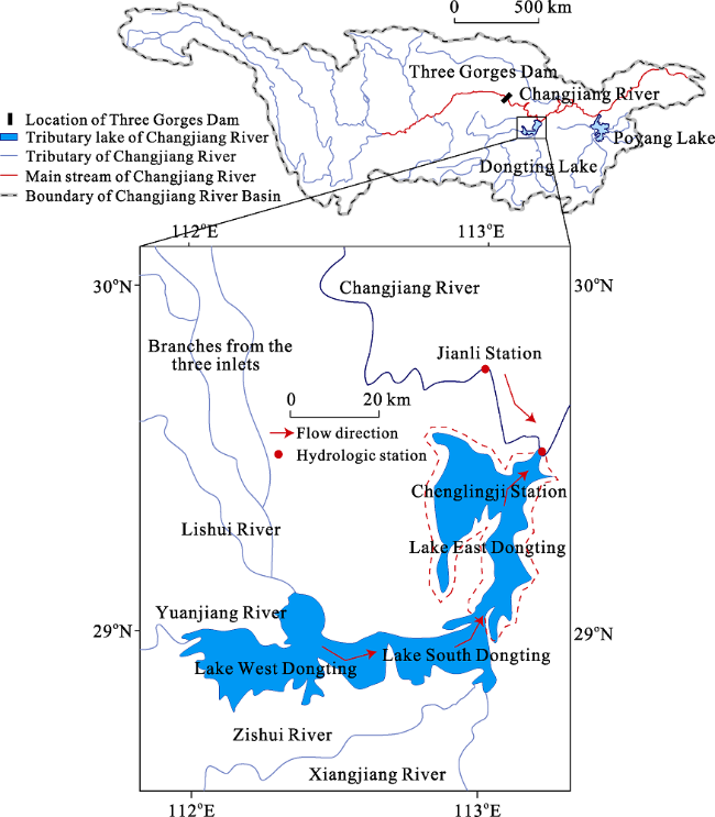
Figure 1 Location and geological map of Lake East Dongting

2.2 Data collection

Daily water level and discharge data (1980-2014) at two gauging stations, i.e., the Chenglingji station and the Jianli station, were used in this study. Jianli station, marked by a red dot in Figure 1, is located in the most strikingly meandering section of the middle Changjiang River, i.e., the Jianli reach. It is connected with Dongting Lake at tail reach. Chenglingji station is located exactly at this connection, which is also marked by a red dot in Figure 1. Thus, Jianli station, located at the main opening of the Jianli reach, can monitor the hydrologic conditions of the Changjiang River. While Chenglingji station, located on the outlet of the Dongting Lake, can monitor the water regimes of Lake ED. All those daily data are from the Hydrological Bureau of Jiangxi Province (http://www.jxsl.gov.cn/), which are continuous with no missing values.

2.3 Approaches to estimating the main stream impact on its tributary lakes

Stage-discharge relationship curves (also referred to as Rating curves) are widely used in the water hydraulics field to assess the capacity for conveying water (Dottori et al., 2009; Wolfs and Willems, 2014). Hence, the rating curves of Chenglingji outlet were used to investigate Lake ED’s discharge ability in this study. To quantify the impact of the Changjiang River on the Lake ED’s discharge ability, different rating curves of Lake ED yield under different hydrologic conditions of the Changjiang River were compared. To be specific, the rating curves of Lake ED were fitted separately in each group, which were divided by the evenly spaced Changjiang River runoff. The average distance between adjacent rating curves was calculated as the water level variation amplitude of Lake ED triggered by the variation of Changjiang River runoff, as shown in Figure 2.
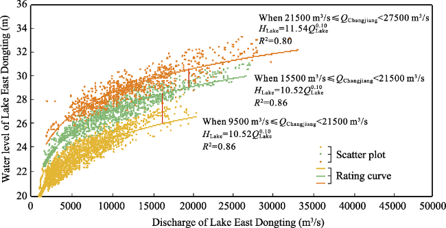
Figure 2 An example of how to measure the Changjiang River’s effect on its tributary lake, East Dongting (Lake ED). The QChangjiang in the legend is the runoff volume of the Changjiang River (m3/s), HLake is the water level of Lake ED (m), QLake is the discharge volume of Lake ED (m3/s). When runoff of the Changjiang River is in the 21,500-27,500 m3/s range, 15,500-21,500 m3/s range, and 9500-15,500 m3/s range, the rating curves of Lake ED fit well (R2=0.82, 0.86, 0.80, respectively) and are nearly parallel with each other. As noted, when the runoff of the Changjiang River decreases with a step interval of 6000 m3/s from 27,500 m3/s to 9500 m3/s, the lake water level drops by h1 (in the maximum river runoff range) and h2 m (in the minimum river runoff range) at equal lake discharge. Hence, we interpreted the distances, for example, h1 and h2, as the impact of the Changjiang River on the water level of Lake ED during specific hydrologic conditions.
In each group divided by the certain range of the Changjiang River runoff, a power-law function fit the rating curve of Lake ED as follows:
${{H}_{\text{Lake}}}=aQ_{\text{Lake}}^{b}$ (1)
Power-law function is commonly untilized and proved to be effective in many hydrometric practice for rating curve (Leon et al., 2006; Dottori et al., 2009; Jalbert et al., 2011; Wolfs and Willems, 2014; Kashani et al., 2015). In this equation, QLake is the discharge of Lake ED (m3/s), HLake is the water level of Lake ED (m), a and b are empirical parameters.
This method measures the impact of the Changjiang River on water regimes of Lake ED via the detection of lake water level variation amplitude at equal lake discharge under different hydrologic conditions of the Changjiang River, i.e., the spacing survey measurement of those rating curves (Figure 2), which offers both quantitative insights into the effect and allows for actual physical interpretation of the river-lake interaction.

3 Results

3.1 Recent water level changes in Lake East Dongting

As shown in Figure 3a, the linear regression of the annual mean water level from 1980 to 2014 shows a general downward trend (slope: -0.02 m year-1). The annual average water level in Lake ED decreases by 0.48 m from 2003-2014 when compared to the previous decades (1980-2002). The four seasonal mean water levels (Figures 3b-3e) show various fluctuating trends from 1980-2014. In summer and autumn, the linear regressions of the seasonal mean water level show a similar declining trend to that of the annual mean water level but at differing amplitudes (slope: -0.02 and -0.08 m year-1, respectively). Among them, the ebb of the water level in summer during 1980-2014 is not significant (P=0.36). While the decline during the summer months after 2003 is observable, that is 0.87 m lower than the 1980-2014 average. The reduction of water levels in autumn is significant (P< 0.001). The most dramatic declines since 2003 occurred in autumn, of which the seasonal mean water level is 1.55 m lower than the average from 1980-2002. In winter and spring, however, the linear regressions of the seasonal mean water level show an upward trend (both the slopes of these seasons were 0.01), although the average rises since 2003 are both within 0.1 m (by only 0.07 m in winter and 0.02 m in spring). In sum, there is a clear decrease in the water levels of the Lake ED during 1980-2014; however, the changing trend of the lake level is due to obvious seasonal variations. The declines in summer and autumn are substantial, while there are merely slight risings for water levels in winter and spring.
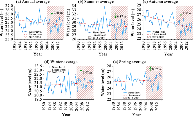
Figure 3 Water level changes within Lake East Dongting during 1980-2014

3.2 The effect of Changjiang River on Lake East Dongting

The stage-discharge curves of Lake ED reflect the Lakes’ capacity to convey water into the downstream Changjiang River, which depends largely on water regimes of the Changjiang River, as shown in Figure 4a. The rating curves of Lake ED were fitted separately in each group divided by the evenly spaced Changjiang River runoff with an interval of 3000 m3/s. The maximum and minimum of the river runoff are respective 3510 m3/s and 45,400 m3/s during 1980-2014, thus 14 rating curves of Lake ED were fitted between the available river runoff range. They are marked by letters from A to N to list the water regime of the Changjiang River from dry to flood in alphabetical order. All the rating curves of Lake ED fit well with the R2 scoring an average of 0.81 (SD 0.05). The spacing between adjacent rating curves illustrates the impact of the Changjiang River on water regimes of the Lake ED at the given level of river runoff. For example, the bottom orange line marked by A and the penultimate gray line marked by B in Figure 4a are the rating curves of Lake ED when the runoff of the Changjiang River is in the 3500-6500 m3/s range and the 6500-9500 m3/s range, respectively. In these two situations, as runoff of the Changjiang River increased by a step with an interval of 3000 m3/s from A to B, the average lake water level at equal lake discharge increased by nearly 1.45 m. The physics concept of the 1.45 m means: a variation of 3000 m3/s in Changjiang River runoff would change the lake water level by 1.45 m when the river runoff at the level of 6500 m3/s or so (effectively within the range [3500, 9500] m3/s). In the same way, the spacing between any pair of adjacent rating curves was estimated, which versus the corresponding median values of the Changjiang River runoff interval limitation was then charted in Figure 4b. It depicts the impact of the Changjiang River on Lake ED in a quite clear and intuitive way.
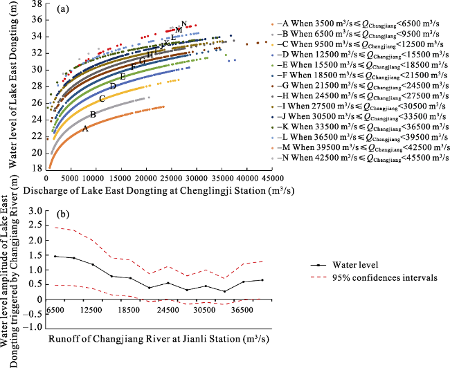
Figure 4 The effect of the Changjiang River on Lake East Dongting (Lake ED) at various runoff magnitudes. (a) The rating curves of Lake ED in various categories separated by the interval limitations of the Changjiang River runoff. The QChangjiang in the legend is the discharge of the Changjiang River (m3/s). (b) The spacing between adjacent lake rating curves, interpreted as the effect of the Changjiang River to Lake ED, at corresponding Changjiang River runoff magnitudes.
As shown in Figure 4b, the degree to which the Changjiang River affects Lake ED varies with the river runoff magnitudes. The strongest influence of the Changjiang River occurs when the river runoff is less than 18,500 m3/s, which usually occurs in the spring, autumn, and winter months. The Changjiang River with runoff in this range can raise the water level of Lake ED by approximately 1.1 m per 3000 m3/s. When the river runoff is higher than 18,500 m3/s, which usually occurs in the summer months, the impact of Changjiang River begins to decrease rapidly and, by 33,500 m3/s, the influence is less than 0.3 m per 3000 m3/s. On average, the influence of Changjiang River to water levels of Lake ED with river runoff in the 18,500-33,500 m3/s range is only 0.4 m per 3000 m3/s. When the river runoff becomes higher than 36,500 m3/s, which only occurs during the peak summer floods, the influence extent of the Changjiang River recovers slightly to around 0.6 m per 3000 m3/s.
The Changjiang River acts as the local erosion base level for Lake ED. So, changes in the hydrologic condition of the Changjiang River will influence the lakes’ capacity to convey water at the outlet. From the quantitative point of view, our results indicate that the influence of the Changjiang River on the conveying ability of Lake ED undergoes seasonal turnovers. This process is a result of the varying hydrological processes in both Lake ED and the Changjiang River, as well as the associated river-lake interaction. Hence, before we explain this result, it is critical to reiterate the annual variations of water regime in the middle reaches of the Changjiang River. This brief review will help readers to comprehend the river-lake interaction discussed in this section.
In spring, the Lake ED is significantly recharged from its catchment basin due to the Asian monsoons. Increasing discharge of Lake ED causes a rapid rising lake water level and steep water gradient at the outlet. Given the large amount of lake discharge and steep water surface gradient at outlet, even a small variation in Changjiang River runoff can cause a dramatic amplitude of lake water level in spring. As is illustrated in Figure 4b, the Changjiang River with runoff less than 18,500 m3/s is of the most powerful in a year, which can raise the water level of Lake ED by approximately 1.1 m per 3000 m3/s.
In summer, because of the northwestward flow of the monsoon front, discharge of the Lake ED diminishes, and the Changjiang River runoff increases. The decreasing discharge of Lake ED is heavily blocked by the increase of the Changjiang River runoff and the water gradient at the lake outlet diminishes accordingly. In this condition, the banked-up water levels of Lake ED become higher and reach the highest point of the year despite the decreasing discharge of Lake ED. Thus, the high-water level of Lake ED in summer is the result of the increased blocking effect of the Changjiang River, not the decreasing lake recharge. In this condition, although the Changjiang River has a strong blocking effect on Lake ED, the river runoff increases at such a high level can only raise the lake water level at a minor degree without backing up by the discharge from the lake watershed. Hence, the influence of the Changjiang River with runoff in the 18,500-33,500 m3/s range is weak, which can raise the water level of Lake ED by only 0.4 m per 3000 m3/s, as is illustrated in Figure 4b. When it comes to the peak summer floods, i.e., when the Changjiang River runoff is greater than 33,500m3/s, the influence of the Changjiang River on Lake ED becomes stronger slightly, but still not as significant as that in spring.
In autumn, the reduction of runoff of the Changjiang River weakened its blocking effect on the outflow of the lake, which could eventually cause the Lake ED to recede. The lake level falls even lower in winter. During these periods, the water gradient at the lake outlet turns to steep again and the lake water level is dominated by the lake discharge again. This situation is similar to that of spring except for the magnitude that does not match. Thus, the influence of the Changjiang River on Lake ED is also significant in autumn and winter like the conditions in spring.
Overall, by comparing the rating curves of Lake ED under different conditions of the Changjiang River, we quantitatively evaluated the influence of the Changjiang River on the tributary Lake ED.

3.3 Water level variations in Lake East Dongting triggered by the changing hydrologic condition of the Changjiang River

The impact of the Changjiang River on Lake ED at different river runoff magnitudes was quantitatively evaluated in the previous section. In this section, we collected further information about changes in the runoff of the Changjiang River before and after 2003, which could partition the lake water level variations triggered by the Changjiang River.
Seasonal turnovers of the runoff of the Changjiang River before and after 2003 are illustrated in Figure 5. The box plot for summer (Figure 5a) indicates that the interquartile range of the summer runoff of the Changjiang River in 1980-2014 is within the 18,500- 33,500m3/s range. The above-mentioned analysis has estimated the influence of the Changjiang River at the given level of river runoff. Hence, as the Changjiang River runoff in summer decreased by 2354 m3/s after 2003, the drop of water level of Lake ED caused by the receding of the Changjiang River should be 0.31 m proportionally. In the other three seasons, turnovers of the Changjiang River runoff before and after 2003 are respectively -2510 m3/s in autumn, 803 m3/s in winter and 363 m3/s in spring. Consequently, the variation amplitudes of the water level of Lake ED triggered by the turnovers of the Changjiang River runoff before and after 2003 should be -0.92 m in autumn, 0.30 m in winter and 0.13 in spring, as shown in Figure 6.
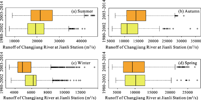
Figure 5 Comparison of the Changjiang River runoff in all four seasons between 1980-2002 and 2003-2014. (a), (b), (c) and (d) are the box plots illustrating the daily mean runoff of the Changjiang River in summer, autumn, winter and spring, respectively.
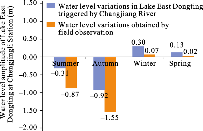
Figure 6 Comparison of the predicted Changjiang River component influences and the observed lake water level variations in all four seasons between 1980-2002 and 2003-2014
Additionally, the water-level amplitude of Lake ED in each season from observational hydrologic data was also calculated and illustrated in Figure 6. As shown in Figure 6, we noted that the observed water level drops in summer and autumn are larger than the lake level reductions triggered by the decreasing Changjiang River runoff. Thus, the decline of the lake water level after 2003 triggered by the Changjiang River would most likely be further exacerbated by some other underlying factors. In winter and spring, the observed water level rises are less than the water level rises triggered by the increasing Changjiang River runoff. That is, the lake water level that should be severely elevated by the Changjiang River would most likely be reduced by some other underlying factors. Thus, there must be underlying factors that pulling down the lake water level throughout the year, which will be briefly analyzed in the following section.

4 Discussion

4.1 Other factors associated with water regime variation of Lake East Dongting

The water regime changes in Lake ED may have many other causes in addition to the Changjiang River. Many scholars have described and speculated about the reasons for the lower annual lake stage and the shifting seasonal water-level fluctuation patterns. They have mainly attributed them to the possible decreased lake inflow and the possible morphological changes. Thus, we verified both the two assumed factors in this study. The results show that (1) the lake inflow in all seasons tended to decrease in 1980-2014, as shown in Table 1. However, none of them passes the significant test at the 0.05 level. That is, the lake inflow in 2003-2014 only has a slight decrease than it was in 1980-2002. (2) The morphological changes at the outlet of Lake ED did include slight scouring in the lake bed in 2007-2012 when comparing the channel profiles in 1984, as shown in Figure 7. The most dramatic elevation drop along the Chenglingji Transect is 1.40 m, which exactly occurs at the thalweg of the lake bed. But the dramatic scouring only occurs near the narrow channel (within a narrow distance range of approximately 900-1000 m to the initial point of the Transect). Elevation drops at other part of lake bed are slight (elevation drop<0.3 m). Overall, the decreases of lake inflow and the eroded lake bed do have contributed throughout the year to lower the water level of Lake ED over the last 30 years. But they only exacerbated the reduction of water level to a small degree. The changing water regime of Lake ED, especially the shifted seasonal water level fluctuation pattern, is impacted mainly by hydrologic changes of the Changjiang River.
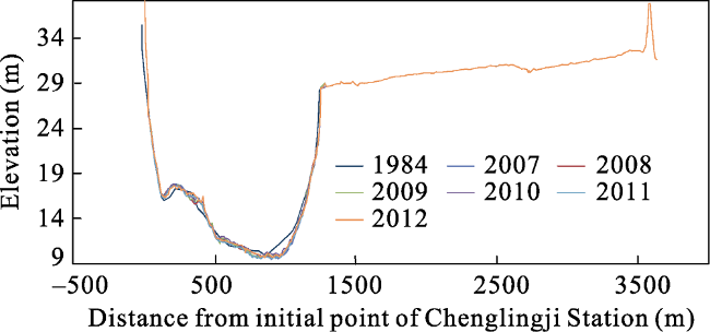
Figure 7 Channel profile changes near the Chenglingji hydrologic station at the outlet of Lake East Dongting
Table 1 Key parameters of linear trend analysis for the total inflow of Lake East Dongting from its four tributary rivers
Slope(billion m3/yr) P-value Intercept(billion m3)
Spring -0.69 0.73 624
Summer -0.49 0.87 537
Autumn -0.47 0.68 168

4.2 Effects of the Three Gorges Dam on Lake East Dongting

The Changjiang River affects the Lake ED through variation of its blocking effect because of the changing river runoff. While the Changjiang River runoff is further controlled by the regulations of the Three Georges Dam (TGD). The TGD, which is located right in the main section of the Changjiang River, holds many records in the history of engineering. It is used to balance the flow of Changjiang River since 2003. As shown in Figure 8, water levels in TGD show a gradual fall in winter, a fluctuating fall in spring, a largely stable in summer and a sharp rise in autumn. This is because that the TGD generally releases water in winter for power generation and relieving the drought conditions downstream. It continues to drain in spring for preparing of flood control. The TGD in summer does not release extra water, or impound water unless at times of extreme flood events. In autumn, the TGD begins to fill with water for the drought conditions in the following dry seasons. Hence, the Changjiang River runoff gets larger in winter and spring, in contrast, gets smaller in summer and autumn under the condition of TGD control versus the natural condition. As the above results show, these variations further impact water regimes of the tributary lakes of the Changjiang River downstream the TGD. Specifically, the extra water releasing of TGD in winter and spring leads to an increasing of the Changjiang River runoff, which further strengthens the blocking effect of the Changjiang River on Lake ED and results in a rise of lake water level at equal lake discharge. While the water impoundment of the TGD in summer and autumn leads to a decreasing of the Changjiang River runoff, which further weakens the reversing effect of the Changjiang River on Lake ED, resulting in lowering water levels in Lake ED. Hence, we confirmed that the abnormal water regime changes in Lake ED after 2003 were indirectly attributable to the operation of the TGD.
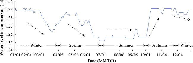
Figure 8 Variations of water levels in the reservoir of The Three Gorges Dam (using the situation in 2007 as an example)

5 Conclusions

Based on the analysis of a typical district, i.e., the Lake East Dongting (Lake ED) and the Changjiang River, we demonstrated that a river can impact the water regime of its tributary lakes significantly. This study presented a method based on dynamically corrected rating curves to measure the impact of a trunk river on its tributary lakes, which is among the first to deliver both quantitative results and allow for physical interpretation of this issue. Additionally, in this study, we also attempted to clarify other relative factors for lake water regime changes, including the total inflow of the lake and the morphological changes at the lake outlet. The indirect effects of TGD on Lake ED through regulation of the Changjiang River runoff were also briefly introduced in this research.
(1) Water regime changes in Lake ED during 1980-2014 were revealed in this study. The annual mean water level of Lake ED has a clear downward trend (slope: -0.02 m year-1) during 1980-2014. The seasonal water level fluctuation pattern of Lake ED has been shifted dramatically. The lake water levels in autumn and summer have a substantial decline (slope: -0.02 and -0.08 m year-1, respectively). While the lake water levels in winter and spring have a slight rise (slope: 0.01 and 0.01 m year-1, respectively).
(2) The Changjiang River does exert a huge impact on the water regimes of Lake ED. The influence extent of the Changjiang River varies substantially with the river runoff magnitudes. A variation of 3000 m3/s in Changjiang River runoff would change the lake level by about 1.1 m when the river runoff is less than 18,500 m3/s, by about 0.4 m when the river runoff is in the 18,500-33,500 m3/s range, and by about 0.6 m when the river runoff is greater than 33,500 m3/s.
(3) The change in hydrologic conditions of the Changjiang River is the main reason for water regime variations in Lake ED. Turnovers of the Changjiang River runoff before and after 2003 are respective -2354 m3/s in summer, -2510 m3/s in autumn, 803 m3/s in winter and 363 m3/s in spring. Consequently, the variation amplitudes of the water level of Lake ED triggered by the turnovers of the Changjiang River runoff should be -0.31 m in summer, -0.92 m in autumn, 0.30 m in winter and 0.13 in spring. Influenced by the reduced lake inflow and the eroded lake bed, the drops of lake water level in summer and autumn triggered by the decreasing Changjiang River runoff are partly aggravated. While the rises of lake water level in winter and spring are partly offset.
(4) The periodic impounding and draining of the TGD is closely related to the variations in water levels of Lake ED. The abnormal water regime changes in Lake ED after 2003 were indirectly attributable to the operation of the TGD. Given that a growing number of water conservancy projects on the Changjiang River would continue to regulate the river flow, the changing water regimes of Lake ED would most likely continue. Regulation of these water conservancy projects that take water regimes of tributary lakes into account in an overview should be proposed.

The authors have declared that no competing interests exist.

1
Chang J, Li J B, Lu D Qet al., 2010. The hydrological effect between Jingjiang River and Dongting Lake during the initial period of Three Gorges Project operation.Journal of Geographical Sciences, 20(5): 771-786.Based on the measured hydrological data from 1951 to 2008, the chain hydrological effect between Jingjiang River and Dongting Lake is analyzed by comparative method after the Three Gorges Project operation. The result indicates that 1) the scouring amount in Jingjiang River made up 78.9% of the total from Yichang to Chenglingji, and its average scouring intensity was higher than the latter; 2) the water and sand diversion rates at the three outlets of the Jingjiang River were reduced by 2.33% and 2.78% separately; 3) the proportion of multi-year average runoff and sediment through the three outlets in the total into the Dongting Lake decreased by 7.7% and 24.4% respectively; 4) in Dongting Lake, the speed of sediment accumulation was lowered by 26.7%, in flood season, the runoff amount was 20.2% less than the multi-year average value, leading to seasonal scarcity of water year by year. The former prolonged the lake life, while the latter induced droughts in summer and fall in successive years, shortage of drinking and industrial water, shipping insecurity, as well as ecological problems such as decrease of birds and quick increase of Microtus fortis; 5) The multi-year average values of sediment and flood transporting capacity at the lake outlet were respectively increased by 26.6% and 3.7%, the embankments were protected effectively. Then, to adapt to the new change of the river-lake relation, some suggestions were put forward, such as optimizing further operation program of the Three Gorges Reservoir, reexamining the idea of river and lake regulation, and maintaining connection of the river and the lake.

DOI

2
Cooke G D, Welch E B, Peterson S et al., 2005. Restoration and Management of Lakes and Reservoirs. United States: CRC Press.

3
Dai X, Wan R R, Yang G S, 2015. Non-stationary water-level fluctuation in China’s Poyang Lake and its interactions with Yangtze River.Journal of Geographical Sciences, 25(3): 274-288.

DOI

4
Darwish K, Smith S E, Torab Met al., 2017. Geomorphological changes along the Nile Delta coastline between 1945 and 2015 detected using satellite remote sensing and GIS.Journal of Coastal Research, 33(4): 786-794.This study describes geomorphologic changes along the Nile Delta coastline between 1945 and 2015. The study used topographic maps produced by the Egyptian Geological Survey in 1945 and Landsat satellite imagery taken between 1973 and 2015. The study found that the coastline's geomorphology greatly changed during this time period, especially at Damietta and Rosetta promontories, which were highly eroded after construction of the Aswan High Dam. Other stretches of the coastline also eroded, while some accretion occurred along the coastline down-drift from the promontories. The trend has been erosion of the beaches along the Nile promontories and accretion within the embayments between the promontories, resulting in an overall smoothing of the coastline. A portion of the eroded material has accreted in the form of spits or shoals near the inlets. The principal causal factors of coastline change were the impacts of the Aswan High Dam, sea-level rise, land subsidence, storms, and coastal protection devices. Efforts to stop erosion have had mixed results. Seawalls built along the city of Alexandria have maintained the coastline, while other coastal protection devices have not impeded erosion. Areas of cultivated land are highly susceptible to saltwater intrusion due to sea-level rise and the fact that much of the delta is at or near sea level.

DOI

5
Dong M, Zou B, 2014. Research in the Dongting Lake: Resource Utilization, Environment Protection and Regional Development. Changsha: Central South University Press.

6
Dottori F, Martina M L V, Todini E, 2009. A dynamic rating curve approach to indirect discharge measurement.Hydrology and Earth System Sciences, 13(6): 847-863.The operational measurement of discharge in medium and large rivers is mostly based on indirect approaches by converting water stages into discharge on the basis of steady-flow rating curves. Unfortunately, under unsteady flow conditions, this approach does not guarantee accurate estimation of the discharge due, on the one hand, to the underlying steady state assumptions and, on the other hand, to the required extrapolation of the rating curve beyond the range of actual measurements used for its derivation. <br><br> Historically, several formulae were proposed to correct the steady-state discharge value and to approximate the unsteady-flow stage-discharge relationship. In the majority of these methods, the correction is made on the basis of water level measurements taken at a single cross section where a steady state rating curve is available, while other methods explicitly account for the water surface slope using stage measurements in two reference sections. However, most of the formulae available in literature are either over-simplified or based on approximations that prevent their generalisation. Moreover they have been rarely tested on cases where their use becomes essential, namely under unsteady-flow conditions characterised by wide loop rating curves. <br><br> In the present work, an original approach, based on simultaneous stage measurements at two adjacent cross sections, is introduced and compared to the approaches described in the literature. The most relevant feature is that the proposed procedure allows for the application of the full dynamic flow equations without restrictive hypotheses. The comparison has been carried out on channels with constant or spatially variable geometry under a wide range of flood wave and river bed slope conditions. The results clearly show the improvement in the discharge estimation and the reduction of estimation errors obtainable using the proposed approach.

DOI

7
Dynesius M, Nilsson C, 1994. Fragmentation and flow regulation of river systems in the Northern 3rd of the World.Science, 266(5186): 753-762.

DOI

8
Gao J H, Jia J, Kettner A J et al., 2015. Reservoir-induced changes to fluvial fluxes and their downstream impacts on sedimentary processes: The Changjiang (Yangtze) River, China. Quaternary International. .

9
Guo H, Hu Q, Zhang Qet al., 2012. Effects of the Three Gorges Dam on Yangtze River flow and river interaction with Poyang Lake, China: 2003-2008.Journal of Hydrology, 416(24): 19-27.The Three Gorges Dam (TGD) has been in operation since 2003. Over the operation period from 2003–2008, data have been collected for preliminary evaluations of actual effects of the TGD on the Yangtze River flow and river interactions with downstream lakes and tributaries. These effects are examined in this study, after the climate influence was minimized by comparing hydrological changes between years of similar climate conditions before and after the operation of the TGD. Major results show that the TGD operation has affected the Yangtze River discharge and water level. The significance of these effects varies seasonally and with different locations along the river. The seasonal variation follows the TGD’s seasonal impounding and releasing of water. The magnitude of the effects is dependent on the impounding/releasing rate and the seasonal flow of the river. The most significant effects are confined in the river reach near the TGD and are as great as five times those of sections downstream. The weakening and diminishing of effect of the TGD is primarily because of “dilutions” to the effect by inflows to the Yangtze River from downstream tributaries. Changes in the Yangtze River discharge caused by the TGD have further altered the interrelationship between the river and Poyang Lake, disturbing the lake basin hydrological processes and water resources. A major consequence of such changes has been a weakening in the river forcing on the lake, allowing more lake flow to the river from July–March. This effect of the TGD may partially fulfill the TGD’s mission to mitigate flood risks in the lake basin, especially during the peak wet season of the Yangtze River basin from July–September. In the 6 years since the TGD operation began the annual average number of severe outflow events of rates of 823000 m 3 s 611 from the lake in July–September has increased by 74. It has also resulted in reduction of water storage in Poyang Lake. Results of this study point to strong needs for working strategies to balance the TGD impacts on flood control and water resources as well as their societal and ecological consequences in the Poyang Lake basin. Meanwhile, in the context of studies of impacts of large dams this study shows an example of extending the previous studies in the dam–river setting to a new dam–river–lake construct.

DOI

10
Hu Q, Feng S, Guo Het al., 2007. Interactions of the Yangtze River flow and hydrologic processes of the Poyang Lake, China.Journal of Hydrology, 347(1/2): 90-100.Recently available hydrological data from Hukou station at the junction of the Poyang Lake with the Yangtze River along with other data from stations in the Poyang Lake basin have allowed further examination and understanding of the basin effect (basin discharge generated by rainfall) and the Yangtze River blocking effect on variations of the Poyang Lake level and floods at annual to decadal scales. Major results show that the basin effect has played a primary role influencing the level of Poyang Lake and development of severe floods, while the Yangtze River played a complementary role of blocking outflows from the lake. In most cases, only when the basin effect weakened did the river effect become large, a relationship indicating that the river’s blocking effect diminishes when the lake level is high from receiving large amount of basin discharge, albeit a few exceptions to this relationship occurred when river flow also was elevated from receiving large rainfall discharges in upstream areas. Moreover, the basin effect has become stronger in the period 1960–2003 in accordance with the increase of warm season rainfall in the Poyang Lake basin. In particular, large increases of the basin’s rainfall in the 1990s corresponded to the most severe floods (in 1998, 1995, and 1992) of the last 4 decades. The strong increase of warm season rainfall in the Poyang Lake basin in the 1990s is consistent with the recent southward shift of major warm season rain bands in eastern China. Results of this study provide a utility for improving predictions of the Poyang Lake level and floods, which affect a population of about 10 million.

DOI

11
Jalbert J, Mathevet T, Favre A C, 2011. Temporal uncertainty estimation of discharges from rating curves using a variographic analysis.Journal of Hydrology, 397(1/2): 83-92.A rating curve provides an estimation of river discharges based on stage (water level). This estimation contains a level of uncertainty. Initial uncertainty occurs at the time of establishment of the rating curve. This may be due, for example, to the randomness of natural processes or to the inaccurate measurement of the stage. Temporal uncertainty is related to the well-known processes of erosion and deposition that modify the geometry of the river bed and, consequently, the relationship between the stage and discharge. As time goes by, temporal uncertainty of the estimated discharge from a rating curve increases. Due to the widespread use of rating curves by scientists and water resource managers, it is important to assess these related uncertainties. Several studies have taken into account initial uncertainties but none, to our knowledge, has considered temporal uncertainties. The aim of this paper is to develop a methodology to estimate the temporal uncertainty of the discharge that is estimated by the rating curve. The proposed approach is based on a variographic analysis. At the beginning of rating curve validity period, the estimated discharge is believed to be distributed as a normal distribution centered on the rating curve estimation. The initial variance of the normal distribution, according to the initial uncertainty, is fixed so that the relative uncertainty is less than 5%. A temporal variance term, estimated using a variographic analysis, is then added to the initial variance to take into account the temporal uncertainty. This term corresponds to the mean of semi-variance between estimations separated by a given time. The proposed method has been applied to 1803 gaugings from 19 hydrometric stations located in the French Alps. The 95% confidence intervals cover 90% of 1803 gaugings. This result shows that the confidence intervals are too short. However, this may be due to an underestimation of the initial variance. The method is efficient and robust since it can be adapted to various station characteristics, such as trends in discharge series or stability of the river bed.

DOI

12
Khasraghia M M, Sefidkouhia M A G, Valipour M, 2015. Simulation of open- and closed-end border irrigation systems using SIRMOD.Archives Agronomy and Soil Science, 61(7): 929-941.In many regions in the world, more than 90% of areas equipped for irrigation apply surface methods. The major problem of the surface irrigation system is low performance due to poor design, operation, and maintenance. Use of the mathematical models for simulation of surface irrigation is necessary for reducing costs and decrease of time in analysis of indexes including application efficiency and distribution uniformity. This study aims to simulate border irrigation systems using the SIRMOD (surface irrigation simulation, evaluation and design, developed by Utah State University, Logan, UT, USA) software package under open- and closed-end conditions. For this purpose, 22 sets of data including four no-cultivated open-end borders, nine no-cultivated closed-end borders, and nine cultivated closed-end borders were used. The results showed that the models predicted open-end conditions better than closed-end for recession time. In addition, the hydrodynamic (HD) and the zero inertia (ZI) models estimated volume of infiltrated water, equal or less than volume of observed water in all the borders. Although the HD model uses the Saint-Venant equations without simplification, during numerical solution of them by the software, uncertainty is raised due to further calculations than the ZI and kinematic wave models. This leads to further error of the HD model than the other models in some cases.

DOI

13
Leon J G, Calmant S, Seyler Fet al., 2006. Rating curves and estimation of average water depth at the upper Negro River based on satellite altimeter data and modeled discharges.Journal of Hydrology, 328(3/4): 481-496.The objective of this study is to derive the stage–discharge relationship for 21 “virtual gauge stations” located at the upper Negro River (Amazon Basin, Brazil). A virtual station can be defined as any crossing of water body surface (i.e., large rivers) by radar altimeter satellite tracks. Rating curve parameters are estimated by fitting with a power law the temporal series of water surface altitude derived from satellite measurements and the discharge. Discharges are calculated using ProGUM, a flow routing model based on the Muskingum–Cunge (M–C) approach considering a diffusion-cum-dynamic wave propagation [Leon, J.G., Bonnet, M.P., Cauhope, M., Calmant, S., Seyler, F., submitted for publication. Distributed water flow estimates of the upper Negro River using a Muskingum–Cunge routing model based on altimetric spatial data. J. Hydrol.]. Among these parameters is the height of effective zero flow. Measured from the WGS84 ellipsoid used as reference, it is shown that the height of effective zero flow is a good proxy of the mean water depth from which bottom slope of the reaches can be computed and Manning roughness coefficients can be evaluated. Mean absolute difference lower than 1.1 m between estimated equivalent water depth and measured water depth indicates the good reliability of the method employed. We computed the free surface water slope from ENVISAT altimetry data for dry and rainy seasons. These profiles are in good agreement with the bottom profile derived from the aforementioned water depths. Also, the corresponding Manning coefficients are consistent with the admitted ranges for natural channels with important flows (superficial width >30.5 m [Chow, V.T., 1959. Open Channel Hydraulics. McGraw-Hill, New York]) and irregular section.

DOI

14
Li J B, Zhou Y Q, Ou C Met al., 2013. Evolution of water exchange ability between Dongting Lake and Yangtze River and its response to the operation of the Three Gorges Reservoir.Acta Geographica Sinica, 68(1): 108-117. (in Chinese)

15
Li Y L, Zhang Q, Werner A Det al., 2016. The influence of river-to-lake backflow on the hydrodynamics of a large floodplain-lake system (Poyang Lake, China).Hydrological Processes, 31(1): 117-132.Abstract Backflow, the temporary reversal of discharge at the outlet of a lake, is an important mechanism controlling flow and transport in many connected river?lake systems. This study used statistical methods to examine long-term variations and primary causal factors of backflow from the Yangtze River to a laterally connected, large floodplain lake (Poyang Lake, China). Additionally, the effects of backflow on the lake hydrology were explored using a physically based hydrodynamic model and a particle-tracking model. Although backflow into Poyang Lake occurs frequently, with an average of 16 backflow events per year, and varies greatly in magnitude between years, statistical analysis indicates that both the frequency and magnitude of backflow reduced significantly during 2001?2010 relative to the previous period of 1960?2000. The ratio of Poyang Lake catchment inflows to Yangtze River discharge can be used as an indication of the daily occurrence of backflow, which is most likely to occur during periods when this ratio is lower than 5%. Statistical analysis also indicates that the Yangtze River discharge is the main controlling factor of backflow during July to October, rather than catchment inflows to the lake. Hydrodynamic modelling reveals that, in general, backflow disturbs the normal northward water flow direction in Poyang Lake and transports mass ~20?km southward into the lake. The effects of backflow on flow direction, water velocities and water levels propagate to virtually its upstream extremity. The current study represents a first attempt to explore backflow and causal factors for a highly dynamic floodplain lake system. An improved understanding of Poyang Lake backflow is critical for guiding future strategies to manage the lake, its water quality and ecosystem value, given proposals to modify the lake?river connectivity. Copyright

DOI

16
Liao M S, Guo J, 2014. Characteristics of temperature and precipitation for the last 32 years in Dongting Lake Basin.Journal of Hengyang Normal University, (6): 109-114. (in Chinese)The pattern and characteristics of climate changes in the Dongting Lake Basin was analyzed with the methods of the linear regression method,Mann-Kendall test method and Morlet wavelets analysis method based on monthly temperature and precipitation data observed at 30 meteorological stations covered the Dongting Lake Basin from 1982 to 2013.The linear regression method was used to study the variation trends of mean temperature and precipitation on annual-scale in recent 32 years.Mann-Kendall test method was used to test trends and abrupt changes of annual mean temperature and precipitation.The Morlet wavelet analysis method was used to detect the change interval of annual mean temperature and precipitation.The results showed:(1)the climate in this region showed a significant warming trend in recent 32 years,the annual mean temperature varied between 15.6℃ and 17.7 ℃,and the annual mean temperature has increased by 0.38 ℃ /10a;The annual precipitation varied between 975.2mm and 1 833.6mm,and the annual precipitation showed a decrease trend in recent 32 years,and decreased by-18.9mm/10 a.(2)The calefactive range was larger in the northern of the Dongting Lake Basin.There are two extreme value centers,one is in Changsha decreased by 0.7℃/10 a,and the other is in Wufeng decreased by 0.98℃/10 a.It was smaller on other areas.The northern and eastern of the Dongting Lake Basin showed significantly decreasing trend in precipitation.whereas,the Sangzhi,Jishou,Yuanjiang and Daoxian showed obviously increasing trend.(3)An abrupt change from low temperature to high temperature occurred in 1998 and the abrupt change in precipitation occurred in 1993 and 2009.(4)The climate change interval analysis revealed that the annual mean temperature fluctuated significantly with the interval of 6years,14 years and 23 years.The annual mean precipitation fluctuated with interval of 3years,6years and 16 years respectively.For this region,the climate was trended to be warmer and dryer in recent 32 years.

17
Liu Y B, Wu G P, Zhao X S, 2013. Recent declines in China’s largest freshwater lake: Trend or regime shift?Environmental Research Letters, 8(1): 014010.

DOI

18
Peters D L, Buttle J M, 2010. The effects of flow regulation and climatic variability on obstructed drainage and reverse flow contribution in a Northern River-Lake-Delta Complex, Mackenzie Basin Headwaters.River Research Applications, 26(9): 1065-1089.A distinctive hydrological feature of the Lake Athabasca–Peace–Athabasca Delta (LA-PAD) complex is that flow in channels that drain the system reverses direction when stage on the Peace River exceeds that for the central lakes. This river's hydrology has experienced natural and human induced changes since 1968. This study investigates the importance of spring break-up and open-water induced outflow obstruction and reverse flow contributions to annual lake level maxima under natural (1960–1967), regulated (1976–2004) and naturalized (1976–1996) flow regimes.Obstructed and reverse flow events during spring break-up were common prior to and following flow regulation, suggesting that natural climatic variability in source areas below the W.A.C. Bennett Dam exerted a strong influence on their occurrence. Antecedent hydrological conditions, such as fall freeze-up lake level, break-up magnitude, peak spring flow and initial open-water lake level were significantly associated with annual lake level maxima. During the summer period, lake level was linked to sustained high flows on the Peace River. The river obstructed outflow and contributed reverse flow to the LA-PAD in each year prior to 1968. Following regulation, however, more than half the years did not experience any open-water obstruction and/or reversal, and those that did were characterized by smaller events. The average estimated duration of obstruction was more than two weeks shorter and reverse flow volume was reduced by 6590% under a regulated regime compared to a simulated naturalized flow regime. This implied a lowered potential for lateral lake expansion into the delta floodplain in some years. The regulated hydrology could produce large stormflow and high lake levels, but only under extreme climatic events in areas below the dam and/or human-induced alterations to normal reservoir operation. Copyright 08 2009 Crown in the right of Canada and John Wiley & Sons, Ltd.

DOI

19
The Ramsar Convention, 2012. The List of Wetlands of International Importance, 25 April 2012.

20
Wang J, Sheng Y, Gleason C Jet al., 2013. Downstream Yangtze River levels impacted by Three Gorges Dam.Environmental Research Letters, 8: 575-591.Changes in the Yangtze River level induced by large-scale human water regulation have profound implications on the inundation dynamics of surrounding lakes/wetlands and the integrity of related ecosystems. Using measurements and hydrological simulation, this study reveals an altered Yangtze level regime downstream from the Three Gorges Dam (TGD) to the Yangtze estuary in the East China Sea as a combined result of (i) TGD’s flow regulation and (ii) Yangtze channel erosion due to reduced sediment load. During the average annual cycle of TGD’s regular flow control in 2009–2012, downstream Yangtze level variations were estimated to have been reduced by 3.9–13.5% at 15 studied gauging stations, manifested as evident level decrease in fall and increase in winter and spring. The impacts on Yangtze levels generally diminished in a longitudinal direction from the TGD to the estuary, with a total time lag of 659–12 days. Chronic Yangtze channel erosion since the TGD closure has lowered water levels in relation to flows at most downstream stations, which in turn counteracts the anticipated level increase by nearly or over 50% in winter and spring while reinforcing the anticipated level decrease by over 20% in fall. Continuous downstream channel erosion in the near future may further counteract the benefit of increased Yangtze levels during TGD’s water supplement in winter and accelerate the receding of inundation areas/levels of downstream lakes in fall.

DOI

21
Waugh J R, Webby M G, 2006. Hydraulic behaviour of the outlet of Lake Wakatipu, Central Otago, New Zealand.Journal of Hydrology (New Zealand), 45: 29-40.

22
Wolfs V, Willems P, 2014. Development of discharge-stage curves affected by hysteresis using time varying models, model trees and neural networks.Environmental Modelling & Software, 55: 107-119.61Modelling rating curves with hysteresis using flow and stage data from one location.61Calibration to simulation results by full hydrodynamic model.61The examined models all outperform the conventional rating curve.61Models obtained via the proposed SDP approach are highly transparent and accurate.61The rarely applied, well interpretable M5′ model trees outperform the neural networks.

DOI

23
Wu J G, Huang J H, Han X Get al., 2008. The Three Gorges Dam: An ecological perspective.Frontiers in Ecology & the Environment, 2(5): 241-248.Abstract The Three Gorges Dam in China is the largest dam ever built. Its impacts on the biodiversity and ecologi- cal processes in the region are causing concern to ecologists worldwide. The dam and associated environ- mental alterations may result in a number of regional changes in terrestrial and aquatic biodiversity, as well as in ecosystem structure and functioning. The dam may also provide a rare opportunity for a grand- scale experiment in habitat fragmentation, allowing ecologists to develop and test a series of hypotheses concerning the dynamics of biodiversity and biotic communities and their responses to disturbances. Such research can help improve conservation practices, stimulate international collaborations, and promote public education on the environment.

DOI

24
Yang S L, Zhang J, Xu X J, 2007. Influence of the Three Gorges Dam on downstream delivery of sediment and its environmental implications, Yangtze River.Geophysical Research Letters, 34(10): L10401.Water and sediment supplies from ungauged areas were calculated and combined with datasets from gauging stations to establish sediment budgets. Using sediment budgets and regression relationships, the influence of the Three Gorges Dam (TGD) on downstream delivery of sediment was quantified. We found that 151 mt/yr (1 mt = 10tons) of sediment has been retained by TGD since it began operation (2003-2005). In response to this, significant erosion has occurred in the downstream riverbed. This erosion did not offset the sediment lost in the reservoir, and the sediment flux into the estuary decreased by 85 mt/yr (31%). This decrease has lead to conversion from progradation to recession in the delta front. In combination with other anthropogenic impacts, TGD was expected to decrease the sediment flux into the estuary for centuries, which is of great importance for delta ecosystem and human development.

DOI

25
Yuan Y J, Zeng G M, Jie Let al., 2015. Variation of water level in Dongting Lake over a 50-year period: Implications for the impacts of anthropogenic and climatic factors.Journal of Hydrology, 525: 450-456.Understanding the variation regularity of water level and the potential drivers can provide insights into lake conservation and management. In this study, inter- and inner-annual variations of water level in Dongting Lake during the period of 1961–2010 were analyzed to determine whether anthropogenic or climatic factor should be responsible for the variations. The results showed that water level decreased significantly during the period of 1961–1980, while increased significantly during the period of 1981–2002 at the 5% significance level. However, the variation trend of water level after 2002 did not reach a significant level. The variation in the dry season was more obviously than that in the wet season. The date when water level was firstly below 24m during the period of 2003–2010 appeared about 27days earlier than usual, and the date was even advanced to mid-September in 2006. As for the duration, water level was below 24m for about 185days in the period of 2003–2010 and 20–30days longer than the other two periods. In conclusion, water level might be influenced by a combination of anthropogenic and climatic factors, with rainfall probably as the main driver responsible for hydrological alteration during the period of 1961–1980 and 1981–2002 while dam construction as the main driver during the period of 2003–2010. Under the circumstance of uncontrollable climate change, effective measures for reservoir operation should be put forward to maintain the ecological integrity and ensure water release and storage capacity of aquatic ecosystems.

DOI

26
Zhang Q, Ye X C, Werner A Det al., 2014. An investigation of enhanced recessions in Poyang Lake: Comparison of Yangtze River and local catchment impacts.Journal of Hydrology, 517: 425-434.Changes in lake hydrological regimes and the associated impacts on water supplies and ecosystems are internationally recognized issues. During the past decade, the persistent dryness of Poyang Lake (the largest freshwater lake in China) has caused water supply and irrigation crises for the 12.4 million inhabitants of the region. There is conjecture as to whether this dryness is caused by climate variability and/or human activities. This study examines long-term datasets of catchment inflow and Lake outflow, and employs a physically-based hydrodynamic model to explore catchment and Yangtze River controls on the Lake’s hydrology. Lake water levels fell to their lowest during 2001–2010 relative to previous decades. The average Lake size and volume reduced by 154km2 and 11×108m3 during the same period, compared to those for the preceding period (1970–2000). Model simulations demonstrated that the drainage effect of the Yangtze River was the primary causal factor. Modeling also revealed that, compared to climate variability impacts on the Lake catchment, modifications to Yangtze River flows from the Three Gorges Dam have had a much greater impact on the seasonal (September–October) dryness of the Lake. Yangtze River effects are attenuated in the Lake with distance from the River, but nonetheless propagate some 100km to the Lake’s upstream limit. Proposals to build additional dams in the upper Yangtze River and its tributaries are expected to impose significant challenges for the management of Poyang Lake. Hydraulic engineering to modify the flow regime between the Lake and the Yangtze River would somewhat resolve the seasonal dryness of the Lake, but will likely introduce other issues in terms of water quality and aquatic ecosystem health, requiring considerable further research.

DOI

27
Zhao J K, Li J F, Yan Het al., 2011. Analysis on the water exchange between the main stream of the Yangtze River and the Poyang Lake.Procedia Environmental Sciences, 10: 2256-2264.Analysis on the hydrologic characteristics of the main stream of the Yangtze River and Poyang Lake were studied to discuss the water exchange between the main stream of the Yangtze River and Poyang Lake before and after the operation of Three Gorges Reservoir, as well as in the typical dry year of 2006. The annual runoff distribution for dry season of Hukou station, located at the outlet of Poyang in 2000s has increased, compared to previous years. And the percentage of runoff in September and October has also increased, compared to 1990s in last century. The water exchange coefficient was 0.51 in the year 2006, which means nearly stable effect between the Yangtze River and the Poyang Lake. Meanwhile, the Poyang Lake provide water supply up to 1564×108m3, accounts for about 23% of the Datong runoff in the same period, and 5% more than the normal year. This is the main reason that the discharge maintained more than 10000m3/s at Datong all over the year 2006, reaching a positive phenomenon of ‘no drought in dry season’

DOI

Outlines

/