Research Articles

The effects of vegetation on runoff and soil loss:Multidimensional structure analysis and scale characteristics

  • LIU Jianbo , 1, 2, 3 ,
  • GAO Guangyao 1, 2 ,
  • WANG Shuai 1, 2 ,
  • JIAO Lei 1, 4 ,
  • WU Xing 1, 2 ,
  • FU Bojie , 1, 2, *
Expand
  • 1. State Key Laboratory of Urban and Regional Ecology, Research Center for Eco-Environmental Sciences, CAS, Beijing 100085, China
  • 2. Joint Center for Global Change Studies, Beijing 100875, China
  • 3. University of Chinese Academy of Sciences, Beijing 100049, China
  • 4. . College of Tourism and Environment, Shaanxi Normal University, Xi'an 710119, China

Author: Liu Jianbo, PhD Candidate, specialized in landscape ecology, runoff and soil erosion.
E-mail:

Received date: 2017-03-07

  Accepted date: 2017-06-02

  Online published: 2018-01-10

Supported by

National Natural Science Foundation of China, No.41390464

National Key Research and Development Program, No.2016YFC0501602

Youth Innovation Promotion Association CAS, No.2016040

Copyright

Journal of Geographical Sciences, All Rights Reserved

Abstract

This review summarizes the effects of vegetation on runoff and soil loss in three dimensions: vertical vegetation structures (aboveground vegetation cover, surface litter layer and underground roots), plant diversity, vegetation patterns and their scale characteristics. Quantitative relationships between vegetation factors with runoff and soil loss are described. A framework for describing relationships involving vegetation, erosion and scale is proposed. The relative importance of each vegetation dimension for various erosion processes changes across scales. With the development of erosion features (i.e., splash, interrill, rill and gully), the main factor of vertical vegetation structures in controlling runoff and soil loss changes from aboveground biomass to roots. Plant diversity levels are correlated with vertical vegetation structures and play a key role at small scales, while vegetation patterns also maintain a critical function across scales (i.e., patch, slope, catchment and basin/region). Several topics for future study are proposed in this review, such as to determine efficient vegetation architectures for ecological restoration, to consider the dynamics of vegetation patterns, and to identify the interactions involving the three dimensions of vegetation.

Cite this article

LIU Jianbo , GAO Guangyao , WANG Shuai , JIAO Lei , WU Xing , FU Bojie . The effects of vegetation on runoff and soil loss:Multidimensional structure analysis and scale characteristics[J]. Journal of Geographical Sciences, 2018 , 28(1) : 59 -78 . DOI: 10.1007/s11442-018-1459-z

1 Introduction

Runoff and soil loss cause substantial on-site and off-site problems such as soil degradation, agricultural productivity decline, flash flooding and the export of nutrients and pesticides, resulting in many ecological and socio-economic problems, especially in arid and semi-arid areas (Pimentel et al., 1995; Zuazo and Pleguezuelo, 2008). Runoff and soil loss are affected by several factors, including rainfall characteristics, topographical features, soil properties and vegetation (Cammeraat, 2004; Fu et al., 2011; Shi and Shao, 2000). The effects of vegetation on runoff and sediment yields are influenced by the structure and function of vegetation (Bautista et al., 2007; Bochet et al., 1998; Zhu et al., 2015). Furthermore, the components of plant species and vegetation pattern are also important factors in controlling soil erosion (Martin et al., 2010; Wang et al., 2012; Fu et al., 2009). Therefore, it is necessary to obtain complete and comprehensive knowledge of the effects of vegetation on runoff and soil loss.
Vegetation can affect runoff and soil loss in various ways (e.g., through vegetation structures, plant diversity levels and pattern distributions). Vertical vegetation structures, including vegetation canopies, litter layers and plant roots, change rainfall redistribution patterns, hydrological processes and soil properties and, in turn, directly or indirectly affect the production of runoff and soil loss (Crockford and Richardson, 2000; Li et al., 2014; Quinton et al., 1997). Plant diversity, especially functional diversity based on plant traits, is a primary indicator of vegetation composition and community characteristics that controls runoff and soil loss by changing the properties of plants and soils (Janssens et al., 1998; Martin et al., 2010). The spatial distribution of vegetation forms a spatial mosaic and source-sink landscape pattern that affect surface runoff accumulation and sediment transport (Puigdefabregas, 2005). The selection of vegetation structures and the arrangement of vegetation distributions are critical in controlling runoff and soil loss (Bochet et al., 1998; Feng et al., 2012; Lu et al., 2012). The above vegetation factors play different roles in affecting runoff and soil loss at different spatial scales (Bergkamp, 1998; Mayor et al., 2011; Puigdefabregas, 2005). Scale issues in combination with other environmental factors (e.g., climate, topography and soil) complicate the effects of vegetation on runoff and soil loss (Bautista et al., 2007; Pannkuk and Robichaud, 2003).
Due to the critical role of vegetation in evaluating runoff and soil loss, the effects of vegetation on runoff and soil loss deserve considerable attention, and abundant information on this issue has been recorded in previous studies. Some reviews on the relationships between vegetation with runoff and soil loss have been published (Gyssels et al., 2005; Puigdefabregas, 2005; Smets et al., 2008; Zuazo and Pleguezuelo, 2008). Gyssels et al. (2005) and Vannoppen et al. (2015) proposed that soil loss reduction resulted from the combined effects of plant roots and aboveground vegetation cover and demonstrated the relative importance of these factors for different erosion processes, but they did not consider the role of the litter layer. Smets et al. (2008) reported that surface litter effectively conserved soil and water, which were affected by slope lengths and erosion types. Puigdefabregas (2005) reviewed how vegetation patterns affected runoff and soil loss at patch and stand scales, and Gumiere et al. (2011) showed that the spatial distribution of vegetated filters was crucial for sedimentological connectivity at the catchment scale, but they ignored the role of vertical vegetation structure. Zuazo and Pleguezuelo (2008) described the effects of vegetation structure and land use patterns on runoff and soil loss, however they did not analyze the effects of plant diversity on runoff and soil loss. Therefore, most previous studies usually explored the role of vegetation based on a particular feature and thus have not adequately explained how vegetation affects runoff and soil loss. Comprehensive analyses on how vegetation controls runoff and soil loss from multidimensional aspects with consideration of scale issues are essential, which is the motivation of the present review.
The objectives of this review are as follows: (1) to systematically summarize the effects of vegetation on runoff and soil loss via a multidimensional analysis of vertical vegetation structures, plant diversity and vegetation spatial distribution (Figure 1); (2) to examine the quantitative relationships between vegetation factors and runoff and soil loss; and (3) to evaluate the primary vegetation factors and mechanisms that control runoff and soil loss at different scales. The present work offers insight into the relationships between vegetation runoff and soil loss scales and presents a scientific basis for ecological restoration efforts.
Figure 1 Multidimensional analysis of the effects of vegetation on runoff and soil loss

2 Effects of vertical vegetation structure on runoff and soil loss

2.1 Aboveground vegetation cover

Aboveground vegetation cover is a major factor affecting the production of runoff and soil loss. Vegetation cover redistributes rainfall into three components (i.e., canopy interception, stemflow and throughfall), thereby weakening rainfall, limiting runoff occurrence and controlling soil erosion (Allen et al., 2014; Crockford and Richardson, 2000). Vegetation type and coverage rates are the most important indicators of vegetation cover that affect runoff and soil loss.
2.1.1 Vegetation type
Different vegetation types have different plant morphologies and vegetation structures, leading to differences in rainfall interception and, in turn, affecting the occurrence of splash erosion and runoff accumulation (Bochet et al., 1998; Calder, 2001). In general, under similar environmental conditions (e.g., climate and topography), shrubs are most efficient in reducing runoff and sediment levels, followed by herbaceous plants and trees (Vasquez- Mendez et al., 2010; Wei et al., 2014). However, the effects of vegetation types were influenced by environmental factors, and the effects on preventing runoff and soil loss varied in different regions (Chirino et al., 2006; Nunes et al., 2011; Sánchez et al., 2002; Wei et al., 2007). For example, forests had been found to be more efficient in reducing runoff and soil loss than pastures in Gansu Province of China, with vegetation cover of 59% and 50%, respectively (Wei et al., 2007), but the opposite had been found in Portugal as afforested land with only 15% of vegetation cover with respect to 71% for pasture land (Nunes et al., 2011). In addition, shrub land in Gansu Province of China and Portugal (with 91% and 92% of vegetation cover, respectively) had the least soil loss (Nunes et al., 2011; Wei et al., 2007), but grassland in Spain (with 70% of vegetation cover) showed better effect on reducing soil loss than that of shrub land (with 90% of vegetation cover) (Chirino et al., 2006). Furthermore, the mean annual precipitation of above regions ranged from 291.7 mm to 823 mm, which was also responsible for the difference of soil loss between different vegetation types. Therefore, the sediment reduction benefit is different under various regions and different types of vegetation.
2.1.2 Vegetation coverage
The coverage rate plays a similarly important role as vegetation type in affecting runoff and soil loss (Elwell and Stocking, 1976). In general, runoff and sediment yields decrease with coverage rates as a linear or exponential function (Figure 2). However, the effects of vegetation on reducing soil loss remain stable when the coverage rate reaches a certain level, i.e., a threshold value, but their effects in terms of reducing runoff continually decrease with an increase in coverage based on the fitted line with average values presented in previous studies, as shown in Figure 2. There are two threshold values of coverage rates: 1) the lower threshold (roughly 10-30%) (Table 1 and Figure 2b), i.e., vegetation can effectively reduce soil loss only when coverage rates reach this threshold value, and 2) the upper threshold (roughly 50-60%) (Table 1 and Figure 2b), i.e., the efficiency of vegetation in reducing soil loss does not increase significantly even when the coverage rate is larger than this threshold value. There are some difference about the threshold values in different regions. As shown in Table 1, Puigdefabregas (2005) concluded that the lower threshold was approximately 10% in semi-arid regions, but it increased to 25% in Kenya (Snelder and Bryan, 1995), to 30% in Spain (Moreno-de las Heras et al., 2009; Quinton et al., 1997), and even to 40% in the Loess Plateau of China (Jiang et al., 1992). For the upper threshold, it was only 50% in Rhodesia (Elwell and Stocking, 1976) and central-east Spain (Moreno-de las Heras et al., 2009), while it became 55% in Kenya (Snelder and Bryan, 1995), and it reached 60% or even 70% in the Loess Plateau of China (Jiang et al., 1992) and southeast Spain (Quinton et al., 1997).
Table 1 The relationships of vegetation and soil erosion under different regions
Reference Region Climate Major conclusions
Vegetation type
Sánchez et al. (2002) Andes, Venezuelan Tropical humid region Soil loss rate: horticultural crops > apple tree > pasture > natural forest
Fusun et al. (2013) Sichuan, China Subtropical humid region Total runoff and soil loss: grass (mid-coverage) > evergreen tree > shrub > deciduous tree
Nunes et al. (2011) Portugal Temperate semi-humid region Runoff rate: afforested land > cereal crop > fallow land > pasture land > shrub land > recovering oak; Soil loss rate: cereal crop > afforested land > fallow land > pasture land > recovering oak > shrub land
Wei et al.
(2007)
Gansu, China Temperate semi-arid region Runoff and soil loss rate: crop land > pasture land > wood land > grassland > shrub land
Chirino et al. (2006) Southeast Spain Temperate semi-arid region Runoff and soil loss rate: bare land > shrub land > grassland
Vegetation coverage
Elwell and Stocking (1976) Rhodesia Tropical (semi)humid region Runoff and soil loss rapidly increased when total vegetal cover fell below 30%,and they kept stability for cover of more than 50%.
Snelder and Bryan (1995) Baringo, Kenya Temperate semi-arid region Soil loss was very low and varied slightly for vegetation cover of 55%-95%, and erosion rates rapidly increased when cover was less than 55%, and reached maximum value for cover of 25% or less.
Moreno-de las Heras et al. (2009) Central- East Spain Temperate semi-arid region A sharp transition of sediment yield occurred between 30% and 50% cover. Less than 30% vegetation cover has very different hydrology responses from that of cases with above 50% cover. The restoration of 50% vegetation cover is decisive.
Quinton et al. (1997) Southeast Spain Temperate semi-arid region Soil loss decreased significantly when vegetation cover increased from 0 to 30%. When the cover exceeded 70%, there was little change.
Puigdefabregas (2005) Semi-arid region Vegetation did not significantly affect runoff and soil loss when the plant cover was less than 10%.
Jiang et al. (1992) Loess Plateau, China Temperate semi-arid region Soil loss decreased by more than 90% for cover of 60-70%. Sediment reduction efficiency decreased significantly when cover was less than 40%.
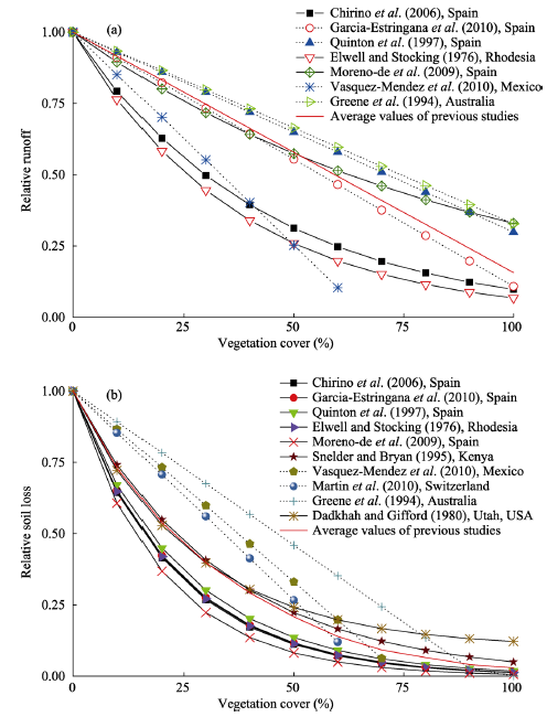
Figure 2 Relationships between vegetation cover and (a) relative runoff (compared to runoff on bare soil) and (b) relative soil loss (compared to soil loss on bare soil)^Note: The dotted and solid lines with marks denote linear and exponential relationships, respectively. The red solid line denotes the fitted results with average values from previous studies. Study areas are shown in the legend followed references
Furthermore, there is a tradeoff between vegetation restoration and water resources in arid and semi-arid areas, and high vegetation coverage rates can result in the depletion of soil water and even land degradation (Wang et al., 2011). It is essential to determine appropriate coverage rates for ecological restoration considering the regional differentiation.
2.1.3 Interaction between vegetation type and coverage rate
The effects of vegetation types and coverage rates on runoff and soil loss are related, and their effects should be considered simultaneously to avoid misunderstanding (Bochet et al., 1998; Vasquez-Mendez et al., 2010). Runoff and soil loss in forests in the Loess Plateau of China (Zhang and Liang, 1996) and shrub in east of Spain (Bochet et al., 1998) with higher canopy density levels were much lower than those in sloping farmland and grassland, respectively, but opposite results had been found when forest and shrub land had a lower coverage rate. Furthermore, runoff and soil loss under various vegetation types were significantly different only when the coverage rate exceeded the lower threshold value in semiarid zone of Mexico (Vasquez-Mendez et al., 2010). Higher coverage rates of planted patches may weaken differences in soil loss among various vegetation types according to the studies in Kenya (Snelder and Bryan, 1995) and in Spain (Quinton et al., 1997).

2.2 Surface litter layer

The litter layer is characterized by its key eco-hydrological functions (i.e., intercepting rainfall, increasing infiltration, interfering with evaporation, decelerating surface runoff, and preventing soil loss) (Li et al., 2014; Pannkuk and Robichaud, 2003; Wang et al., 2013). Furthermore, litter layers can improve soil properties and can help soil resist erosion. Litter types, biomass, coverage rates and thicknesses are the main indicators that affect the degrees to which litter layers conserve soil and water (Findeling et al., 2003; Li et al., 2013; Smets et al., 2008).
Litter layers of different vegetation types present significantly different capacities to intercept rainfall and reduce soil loss (Pannkuk and Robichaud, 2003; Singer and Blackard, 1978). Generally, litter layers have a stronger effect on sediment transport processes than soil detachment, and the effects of litter layers on erosion processes (e.g., interrill and rill erosion) vary among layer types (Pannkuk and Robichaud, 2003). For example, broadleaf and needle forest litter in Northern China reduced runoff yields by 29.5% and 31.3%, respectively, and sediment yields by 85.1% and 79.9%, respectively (Li et al., 2014).
Litter biomass has a considerable effect on runoff and soil loss, although its effects are subject to litter types. The runoff coefficient and soil loss rate generally decrease with litter biomass levels (Findeling et al., 2003). In addition, litter biomass has a threshold value as vegetation coverage rates. Runoff and soil loss remain stable when litter biomass levels reach a threshold value, as a flow channel for runoff is formed by excess litter cover, thus preventing water infiltration (Findeling et al., 2003; Li et al., 2014).
The litter coverage rate is negatively related to runoff and soil loss, and an exponential relationship has been observed between these parameters (Bochet et al., 1998; Shi et al., 2013). Higher litter coverage levels abate sediment transport, especially for clay- and silt-sized particles (Shi et al., 2013). Furthermore, the spatial distribution of litter cover under the same coverage rate significantly affects soil erosion (Singer and Blackard, 1978). Litter thickness is positively correlated with a delay in runoff generation (Liu et al., 1991). It has also been reported that when litter layers reach a certain thickness (2 cm), they can minimize or fully prevent the occurrence of soil erosion in the Loess Plateau of China (Wu et al., 1998).

2.3 Underground roots

2.3.1 Effects of plant roots
Compared to aboveground vegetation cover and surface litter layers, considerable attention has not been paid to the role of underground roots in affecting runoff and soil loss (Gyssels et al., 2005; Katuwal et al., 2013; Sánchez et al., 2002). Gyssels et al. (2005) reviewed that the aboveground vegetative cover was the most important factor to splash and interrill erosion processes, while roots were as important as aboveground vegetation cover for rill and gully erosion processes. Furthermore, the relative contribution of roots to runoff and soil loss reduction varied with vegetation types. The contribution of roots to reduce runoff and soil loss was relatively greater than that of shoots under forest land, while the effects of shoots and roots on soil loss were nearly equal under grassland in the Loess Plateau of China (Zhang et al., 2014).
Roots conserve soil and water through two means: 1) roots can directly protect soil detachment and increase infiltration, thus reducing runoff and soil loss (De Baets and Poesen, 2010; Gyssels et al., 2006; Reubens et al., 2007), and 2) roots can improve soil properties by increasing soil organic matter levels, enhancing the quantity of soil stable aggregates and stabilizing soil layer structures, and subsequently reduce the soil detachment rate (Mamo and Bubenzer, 2001; Pohl et al., 2009).
Many studies have researched the approaches that roots enhance soil anti-erodibility and reduce soil detachment (De Baets et al., 2011; Reubens et al., 2007; Zhou and Shangguan, 2005). Roots reinforce soil in two directions: horizontal and vertical (Burylo et al., 2012b; De Baets et al., 2008; Genet et al., 2005; Reubens et al., 2007). The downward penetration of roots strengthens soil anti-shear capacities, whereas laterally extensive roots reinforce soil stability through their tensile strength (De Baets et al., 2008; Reubens et al., 2007). Roots form underground networks in the above two directions to bind soil particles and then increase soil cohesion.
2.3.2 The relationships of root indexes with runoff and soil loss
The mechanical properties, distribution depths and densities of effective roots (diameter < 1 mm) are the main indicators that affect runoff and soil loss. Effective roots with great tensile strength improve soil properties and limit soil loss (Genet et al., 2005; Pohl et al., 2009). Roots positioned at a depth of 0-30 cm in shrubland and grassland and at 0-60 cm in forests critically affected soil loss in Loess Plateau of China (Liu and Li, 2003). In quantifications of the effects of roots on runoff and soil loss, the distribution density of root systems often acts as a major indicator, including root density (RD), root length density (RLD) and root surface area density (RSAD) (Burylo et al., 2012b; Pohl et al., 2009; Reubens et al., 2007). In general, the infiltration capacity of soil water increases with increased RD levels, and in turn, the potential for runoff generation is reduced (Himmelbauer et al., 2013). RD and RLD are positively correlated with soil stable aggregate levels (Pohl et al., 2009), and their effects on soil detachment are shown in Figure 3. Relationships between soil detachment rates (SDRs) and RD or RLD are exponential for interrill and rill erosion, whereas RD and RLD have almost no effect on SDR for splash erosion. Throughout soil erosion development (i.e., from splash to interrill and rill), the efficiency of RD and RLD in reducing soil loss increases. Furthermore, the RSAD is linearly correlated with soil loss and infiltration rates according to rainfall simulation experiments conducted in Shaanxi Province, China (Zhou and Shangguan, 2007).
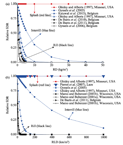
Figure 3 Relationships between the relative soil detachment rate (SDR, relative to detachment for bare soil) and (a) root density (RD) and (b) root length density (RLD) for splash (red line), interrill (blue line) and rill (black line) erosion processes.^Note: data of Gyssels et al. (2005) was concluded from different regions

3 Effects of plant diversity on runoff and soil loss

Vertical vegetation structure plays a key role on runoff and soil loss at the individual plant scale. However, at the community and ecosystem scales, plant diversity is significantly related to runoff and soil loss (Martin et al., 2010; Pohl et al., 2009; Zhu et al., 2015). Plant diversity can affect runoff and soil loss by changing the pattern of vertical vegetation structure. Increased plant diversity levels strengthen the efficiency of aboveground vegetation cover and increase the diversity of litter layers and roots to control runoff and soil loss (Martin et al., 2010; Pohl et al., 2009; Zhou and Shangguan, 2005). Furthermore, plant diversity changes soil physical and chemical properties and indirectly affects runoff and soil loss (Bezemer et al., 2006; Janssens et al., 1998; Pohl et al., 2009). There are two types of plant diversity indicators: the traditional diversity index based on species components and the functional diversity index based on plant traits.

3.1 Effects of traditional plant diversity

Under similar vegetation cover rates, components of more plant species tend to cause an evident decrease in runoff and soil loss (Martin et al., 2010). A negative linear correlation was found between runoff frequency and the plant richness index, and the total amount of runoff and sediment are negatively exponentially correlated with the plant richness index (Wang et al., 2012) and Shannon Index (Bautista et al., 2007). In contrast, studies have shown that there is no significant correlation between plant diversity and soil loss and that it is difficult to identify how plant diversity controls runoff and soil loss, as plant diversity interacts with other plant factors (Shrestha et al., 2010; Casermeiro et al., 2004).

3.2 Effects of plant functional diversity

Compared to traditional plant diversity, functional diversity (FD) is based on plant morphology and physiology in investigating the relationship between community structures and ecological processes (Burylo et al., 2012a; Martin et al., 2010; Villeger et al., 2008). As ecological processes are largely determined by the functional identities of dominant species, the FD can explain more variations in ecological processes than species richness (Mokany et al., 2008; Villeger et al., 2008). Vegetation types, leaf area indexes, biomass levels, root distributions and tensile strengths are considered in the FD, and thus, the FD is highly correlated with soil erosion rates (De Baets et al., 2008; Mouillot et al., 2011; Villeger et al., 2008). Villeger et al. (2008) proposed the following three FD indexes to describe community functional compositions: functional richness (FRic), functional evenness (FEve) and functional divergence (FDiv). The FDiv has a robust negative effect on soil erosion (Zhu et al., 2015). Combining functional diversity with erosion processes proved to be an essential and new approach to explore the effects of plant diversity on runoff and soil loss.

3.3 Effects of plant diversity on soil properties

Plant diversity and soil properties interact with one another, forming mechanisms of plant-soil feedback that are widely found in ecosystems (Bezemer et al., 2006). In general, increased plant diversity levels improve soil properties and enhance their capacities to conserve soil and water (Hooper and Vitousek, 1998). Several studies have found that plant diversity can significantly contribute to nitrogen cycling and can change microbial community compositions (Carney and Matson, 2006; Hooper and Vitousek, 1998; Steinauer et al., 2015), and thus increase soil carbon storage levels and soil N, P and K content (Hager, 2012; Hooper and Vitousek, 1998; Janssens et al., 1998). Moreover, plant diversity has a positive effect on soil stable aggregates and soil porosity, thus enhancing water permeability and the stability of soil in reducing runoff and soil loss (Martin et al., 2010; Pohl et al., 2009; Wang et al., 2012).

4 Effects of vegetation spatial distribution on runoff and soil loss

Spatial distribution of vegetation heavily affects ecological processes in arid and semi-arid regions (Puigdefabregas, 2005; Zhang et al., 2014a). Several studies have classified land cover types into vegetation and bare patches as a basis for researching the effects of vegetation spatial distribution (Imeson and Prinsen, 2004; Liu et al., 2013; Puigdefabregas, 2005; Zhang et al., 2014b). Vegetation patches act as “sinks” that trap runoff and sediment, while bare patches act as “sources” (Cerda, 1997; Puigdefabregas, 2005). Vegetation and bare patches form spatial mosaics (i.e., source-sink landscape patterns) that change landscape connectivity levels and thereby shape the collection of surface runoff and sediment delivery (Bautista et al., 2007; Mayor et al., 2008; Puigdefabregas, 2005). The source-sink structure and landscape connectivity act as dominant landscape characteristics that control runoff and soil loss (Cerda, 1997; Liu et al., 2013; Ludwig et al., 1999).

4.1 Effects of land cover patterns on runoff and soil loss

Land cover patterns, i.e., the spatial distribution of vegetation and bare patches, can greatly affect runoff and sediment yields (Bartley et al., 2006; Bautista et al., 2007). The capacities of stripes and strand banded patterns in converting rainfall into soil water were approximately 8% higher than those of stippled patterns in the semi-arid woodlands of Eastern Australia (Ludwig et al., 1999). However, stripes parallel to a slope direction caused more runoff and sediment loss than stippled patches in the Loess Plateau of China (Zhang et al., 2014a; Zhang et al., 2014b). The configuration of different vegetation types along the slope extension is as important as mosaic vegetation patterns (Bautista et al., 2007; Fu et al., 2009). According to Fu et al. (2009), land use combinations of ‘grass + mature forest + grass’ and ‘grass + young forest + mature forest + grass’ on hill slopes in the Loess Plateau of China can better control soil erosion than ‘grass + shrub’ patterns.
Patch locations constitute another feature of land cover patterns that controls runoff and soil loss (Bartley et al., 2006; Ludwig et al., 2002; Ludwig et al., 1999). More runoff and sediment yields are generated when bare patches are closer to water outlets, whereas the presence of vegetation patches near an outlet can effectively trap runoff and sediment (Bartley et al., 2006). It should be noted that vegetation at the bottom of a slope significantly reduces runoff and sediment yields only when the coverage rate exceeds a certain value (e.g., 20%) (Rey, 2004). In addition, stripe patterns near water outlets are more efficient at reducing runoff and sediment levels than are scattered patches (Bautista et al., 2007; Ludwig et al., 1999).

4.2 Application of pattern indexes to represent vegetation spatial distribution

To quantify the effects of land cover patterns on runoff and soil loss, several pattern indexes have been developed to describe the characteristics of vegetation spatial distribution (Bautista et al., 2007; Imeson and Prinsen, 2004; Jaeger, 2000; Ludwig et al., 2007). The landscape indexes can be divided into two categories: landscape fragmentation and connectivity indexes (Table 2). Landscape fragmentation and connectivity indexes often have opposite effects on runoff and soil loss. In general, the landscape fragmentation indexes shown in Table 2 (e.g., PD, ED, AI and D) present a negative relationship with runoff and soil loss. A framework is proposed in Figure 4 to denote the relative influence of landscape fragmentation and connectivity on runoff and soil loss. Landscapes that tend to be more connective increase runoff and sediment production potential.
Figure 4 The relative potential for runoff and soil loss reduction with changes in landscape fragmentation and connectivity ^Source: based on the relationships shown in Table 2.
Table 2 Definition of pattern indexes and their relationships with runoff and soil loss
Pattern index Abbreviation Definition Relationship with runoff and soil loss Country Reference
Total Landscape Area TA The total vegetation patch area of a landscape. Negative exponential China Hou et al. (2014)
Patch Density PD The number of patches per unit area. Negative second order polynomial Spain;
China
Bautista et al. (2007);
Ouyang et al. (2010)
Edge Density ED The total length of all edge segments per unit area for the class or landscape under consideration. Negative second order polynomial China Ouyang
et al
. (2010)
Shannon’s
Diversity Index
SHDI A measure of patch diversity for a landscape. Negative;
Mixed linear (from positive to negative)
Spain;
China
Bautista et al. (2007);
Hou et al. (2014)
Aggregation
Index
AI A measure of the aggregation of spatial patterns that is scaled to account for the maximum possible number of similar areas in any given landscape composition. Negative linear China;
USA
Hou et al. (2014);
He et al. (2000)
Lacunarity Lacunarity A scale-dependent measure of heterogeneity describing the shape and distribution of gap sizes in fractal geometric landscapes. _ Spain;
*
Imeson and Prinsen (2004); Plotnick et al. (1993)
Bare Area
Fragmentation Index/Degree of Landscape
Division
D The probability that two randomly selected places on the map examined are not situated in the same undissected area, determining how strongly vegetation patches dissect the bare area. Negative Spain;
Germany
Imeson and Prinsen (2004); Jaeger (2000)
Directional Leakiness Index DLI A measure of the distances between patches, indicating the connectivity of bare patches and the potential for a given vegetation pattern to retain resources flowing across surfaces. Positive linear (runoff);
Positive exponential (soil loss)
Australia;
Spain
Ludwig et al. (2002); Bautista et al. (2007)
Modified Directional Leakiness Index DLI_M A modified DLI that is corrected by incorporating the effect of cover types on runoff and sediment generation compared to bare soil and the flow path length to the outlet of each location. Positive linear China Liu et al. (2013);
Flowlength Index Flowlength A measure of the average length of all potential runoff pathways in a landscape based on the connectivity of bare patches (source areas) related to vegetation cover and topography. Positive linear Spain Mayor et al. (2008)
Modified Flowlength
Index
Flowlength_M The modified Flowlength index based on the effect of cover types on runoff and sediment generation compared to bare soil and the flow path length to the outlet of each location. Positive linear China Liu et al. (2013)
Index of
Connectivity
IC A potential connectivity characteristic between sediment eroded from hillslopes and the stream system based on GIS data. Positive Italy Borselli et al. (2008)
Pattern index Abbreviation Definition Relationship with runoff and soil loss Country Reference
Field Connectivity Index FIC An assessment index similar to the IC that is based on field approaches using signs of water flow and sedimentation and that represents ground truth subdivided into upslope and downslope components. Positive Italy Borselli et al. (2008)
Upslope Side Length of Vegetation Patch U An index denoting vegetation patch capacities to catch water flowing downslope. Negative Spain Imeson and Prinsen (2004)
Connectivity of Bare Patches C An index of the potential runoff length describing the degree of connectivity between bare (source) areas within a vegetation-bare soil mosaic landscape (map). Negative Spain Imeson and Prinsen (2004)
Location-weighted Landscape Contrast Index LCI An index for assessing the effect of landscape patterns on sediment yields based on the contributions of different land cover types (source and sink) to soil erosion in a watershed. Positive China;
China
Chen et al. (2003);
Yang et al. (2012)
Soil loss Evaluation Index SL An index for evaluating the relationship between land use patterns and soil erosion based on the main factors of soil erosion, which can be applied at different scales. By upscaling (from a slope to a watershed), more topography factors are considered. _ China Zhao et al. (2012)

‘_’ denotes that a relationship is not clear, and ‘*’ means that there is no definite country.

Most pattern indexes, such as those included in FRAGSTATS, were not developed based on detailed ecological processes and are therefore difficult to use to explicitly measure runoff and soil erosion (Imeson and Prinsen, 2004; Liu et al., 2013; Ludwig et al., 2002). Furthermore, there are uncertainties and contradictions in the relationships between pattern indexes and runoff and soil erosion (Liu et al., 2013; Ludwig et al., 2002; Ouyang et al., 2010). As pattern indexes are interdependent, it is difficult to show how landscape patterns prevent soil erosion using a single pattern index (Bautista et al., 2007; Hou et al., 2014).
Recently, pattern indexes with physical meaning were developed to measure runoff and soil erosion. Ludwig et al. (2002) developed the Directional Leakiness Index (DLI) to determine the potential for a given hillslope vegetation pattern to maintain materials (e.g., soil particles and water), and it was found to be positively and linearly correlated with runoff and exponentially correlated with sediment yields in southeast Spain (Bautista et al., 2007). Mayor et al. (2008) created the Flowlength index, which delineated the pathway length of water flows from each location to sinks such as vegetation patches and topographical depressions (ponds). The index revealed a significantly linear relationship with runoff and sediment yields in southeast Spain. Liu et al. (2013) modified the above two indexes by considering the functional heterogeneity of plant cover types and landscape positions. Fu et al. (2006) and Zhao et al. (2012) proposed a multi-scale soil loss evaluation index that reflects the effects of land use patterns on soil erosion based on the RUSLE C-factor and scale-pattern-process theories. Although the above indexes are significantly correlated with runoff volumes and soil loss and can describe the effects of vegetation spatial distribution, they cannot easily predict runoff and soil erosion levels. It is essential to develop indexes based on detailed hydrological processes in consideration of threshold behaviors and feedback mechanisms to quantify runoff and soil erosion.

5 Scale issues on the relationships of vegetation factors with runoff and soil loss

Scale issues are challenges in the study of runoff and soil loss. Levels and mechanisms of runoff and soil loss and influencing factors are scale-dependent (Ferreira et al., 2005; Nadal-Romero et al., 2011). Runoff and soil loss also present different characteristics and restrictions at different scales (Cammeraat, 2004; de Vente and Poesen, 2005). Furthermore, the sources of runoff and sediment often change across scales. Runoff at small scales mainly results from overland flow (Bautista et al., 2007; Chaplot and Poesen, 2012; Liu et al., 2013), whereas at large scales, base flows reaching stream channels through infiltration
should be considered as an important source (Cammeraat, 2004; Ferreira et al., 2005). At patch and slope scales, sediment mainly results from splash, interrill and rill erosion (Bochet et al., 2006; Gyssels and Poesen, 2003; Wang et al., 2013; Zhou and Shangguan, 2005). However, at watershed and larger scales, in addition to rill erosion, gully erosion and riverbank collapse constitute major sources (de Vente and Poesen, 2005; Pannkuk and Robichaud, 2003; Shi and Shao, 2000). As a result, it is difficult to achieve a direct scaling of runoff and soil loss. Patterns of runoff and soil loss and effects of vegetation should be summarized at different scales from a hierarchical perspective (Bergkamp, 1998).
Figure 5 presents major vegetation factors of runoff and soil loss at different scales. The functions of vegetation in conserving water and soil are also scale dependent. Furthermore, the effects of vegetation on runoff and soil loss at different scales are subject to other environmental factors (e.g., climate, topography, and soil properties). Specially, extreme rainfall events may increase the complexity and uncertainty of the effects of vegetation on erosion processes (González-Hidalgo et al., 2007; Wei et al., 2009). Heavy rain storms often caused landslides, debris flows, flooding and severe soil erosion, which had 1.5-53.1 times of erosion rate than mean annual rates and accounted for more than 50% or even 75% of annual soil erosion (Cheng et al., 2002; González-Hidalgo et al., 2007; Ramos and Martinez-Casasnovas, 2009; Shi and Shao, 2000; Wei et al., 2009). However, extreme rainfall events not always led to serious erosion, which depended on other factors such as crop growth stage, vegetation cover and cultivated landscapes (Boardman, 2015). Generally, the impacts of environmental factors increase with scale expansion (Figure 5).
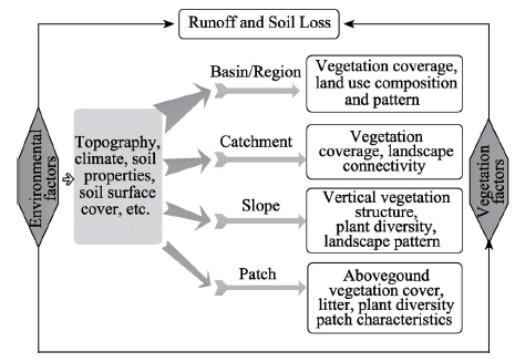
Figure 5 Major vegetation factors of runoff and soil loss at different scales and the effects of environmental factors^Note: The width of the arrow denotes the level of the influence of environmental factors.
At the patch scale, vertical vegetation structure (plant morphology, vegetation coverage rates and surface litter layers) is the main vegetation factors that control runoff and sediment yields (Bochet et al., 1998; Dadkhah and Gifford, 1980; Martin et al., 2010; Snelder and Bryan, 1995). Within the same area of vegetation cover, plant diversity acts on runoff and soil loss (Martin et al., 2010). Influenced by patch characteristics, soil properties, surface rocks and surface crusting affect erosion processes (Bautista et al., 2007; Cammeraat, 2004; Pannkuk and Robichaud, 2003).
At the slope scale, due to the development of interrill and rill erosion, in addition to aboveground vegetation cover and litter, plant roots must be considered as a crucial factor (Gyssels et al., 2005). Vegetation distribution patterns determine landscape fragmentation and connectivity, and plant diversity contributes greatly to runoff and sediment yields (Bautista et al., 2007; Hou et al., 2014; Pohl et al., 2009; Wei et al., 2014). Several studies have concluded that topography (e.g., slope gradient and slope length) shapes the effects of vegetation on runoff and sediment (Donjadee and Chinnarasri, 2012; Liu et al., 2012; Sadeghi et al., 2013). In addition, landscape connectivity affects runoff to a greater extent in heavy rainfall-runoff events (Bautista et al., 2007; Mayor et al., 2008).
At the catchment scale, although vegetation coverage still contributes significantly to runoff and sediment yields, such effects weaken with an increase in watershed area and variation in land use types (Cammeraat, 2004; de Vente and Poesen, 2005; Pierret et al., 2007). In such cases, landscape connectivity plays a key role in the production of runoff and sediment loads that enter river channels, and topographic features and the connectivity of channel networks become major factors that control the transport of runoff and sediment yields into catchment outlets (Cammeraat, 2004; Ferreira et al., 2005; Mayor et al., 2011).
At the basin and regional scales, land use compositions and patterns are the main vegetative factors that explain variations in sediment yields (Fu et al., 2011; Lu et al., 2012; Shi et al., 2014). Sediment sinks have a more central role than sources, and vegetation restoration is very effective in decreasing runoff and sediment yields (Butt et al., 2010; de Vente and Poesen, 2005; Feng et al., 2012; Lu et al., 2012). The relationship between runoff and sediment in a basin channel is determined based on regional landforms, i.e., the topography of hills and slopes, river network characteristics and connections between channels (Cammeraat, 2004). Variations in regional precipitation also create differences in vegetation cover and erosion levels among different regions (Feng et al., 2012; Lu et al., 2012).

6 Further issues and prospects

This paper summarizes the effects of vegetation on runoff and soil loss in various dimensions (e.g., vertical vegetation structures, plant diversity and vegetation spatial distribution) and their scale characteristics. The relationships involving vegetation, erosion and scale are summarized in Figure 6, which shows the relative importance of each dimensional characteristic in various erosion processes across scales. With erosion development (from splash to gully), the main factor of the vertical vegetation structure in controlling runoff and soil loss changes from aboveground vegetation cover to roots. Furthermore, plant diversity exhibits a closer relationship with vertical vegetation structure and plays a more critical role at smaller scales, while landscape patterns closely related to canopy cover also play a critical role across scales. Therefore, considering a certain dimension of vegetation characteristics alone cannot fully explain how vegetation affects runoff and soil loss. The findings presented here serve as a key reference for vegetation restoration efforts to control runoff and soil loss at different scales.
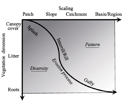
Figure 6 Framework of the relationships among vegetation, erosion and scale^Note: the darker color denotes a stronger relationships between vegetation factors and a given erosion process.
Certain issues are in need of further study. (1) First, it is necessary to identify isolated ways in which different vertical vegetation components control runoff and soil loss. The three aspects of vertical vegetation structure have their own functions, and their efficiencies are interdependent. Understanding their roles will be useful for determining the efficient architectures and morphologies of vegetation for ecological restoration. (2) Second, more effort should be made in quantifying the vertical structure of vegetation and incorporating it to the models such as RUSLE to meet the forecast demand. (3) Third, we should develop a comprehensive approach to describe the dynamics of vegetation patterns and incorporate them into pattern index based on detailed hydrological processes, which can be used to quantitatively predict runoff and soil loss levels. (4) Fourth, the relative importance of each dimension and the interactions among the three dimensions of vegetation in affecting runoff and soil loss at different scales should be determined. (5) Finally, we must enhance efforts to describe the quantitative relationships between vegetation factors and runoff and soil loss at different scales and develop upscaling models that relate the results at different scales.

The authors have declared that no competing interests exist.

[1]
Allen S T, Brooks J R, Keim R Fet al., 2014. The role of pre-event canopy storage in throughfall and stemflow by using isotopic tracers.Ecohydrology, 7(2): 858-868.Stable isotopes can be a valuable tool for tracing the redistribution, storage, and evaporation of water associated with canopy interception of rainfall. Isotopic differences between throughfall and rainfall have been attributed to three mechanisms: evaporative fractionation, isotopic exchange with ambient vapor, and temporal redistribution. We demonstrate the potential importance of a fourth mechanism: rainfall mixing with water retained within the canopy (in bark, epiphytes, etc.) from prior rain events. Amount and isotopic composition (18O and 2H) of rainfall and throughfall were measured over a 3-month period in a Douglas-fir forest in the Cascade Range of Oregon, USA. The range of spatial variability of throughfall isotopic composition exceeded the differences between event-mean isotopic compositions of rainfall and throughfall. Inter-event isotopic variation of precipitation was high and correlated with the isotopic deviation of throughfall from rainfall, likely related to a high canopy/bark storage capacity storage bridging events. Both spatial variability of throughfall isotopic composition and throughfall090009precipitation isotopic differences appear to have been controlled by the temporally varying influence of residual precipitation from previous events. Therefore, isotopic heterogeneity could indicate local storage characteristics and the partitioning of flow-paths within the canopy. Copyright 0008 2013 John Wiley & Sons, Ltd.

DOI

[2]
Bartley R, Roth C H, Ludwig Jet al., 2006. Runoff and erosion from Australia's tropical semi-arid rangelands: Influence of ground cover for differing space and time scales.Hydrological Processes, 20(15): 3317-3333.Abstract This paper highlights the relevant issues influencing the amount and arrangement of ground cover in savanna rangelands in Australia, and presents field measurements from hillslope scale flumes, which demonstrate how runoff and sediment loss vary with spatial patterns in ground cover. Hillslopes with relatively high mean cover, but with small patches bare of vegetation, are shown to have between 6 and 9 times more runoff, and up to 60 times more sediment loss than similar hillslopes that do not contain bare patches. The majority of sediment lost from the hillslopes is composed of fine (suspended) rather than coarse (bedload) material, although the absolute sediment loads are comparatively low. These low loads are considered to be the result of lower than average rainfall during the measurement period (2002–2005) and the high and prolonged rates of historical hillslope erosion that have exhausted the erodible material from the A-horizon. The collected data also demonstrate that a large proportion of soil is lost during the initial ‘flushing’ period of runoff events. The results presented have important implications for the management of savanna grazing systems by highlighting (i) the significance of bare patches in contributing to runoff and soil loss from hillslopes; (ii) the importance of having medium to high cover patches at the bottom of hillslopes for trapping and storing sediment and therefore reducing its entry into the stream network; and (iii) how maintenance of ground cover during the dry season reduces sediment concentrations in runoff occurring early in the wet season. Copyright 08 2006 John Wiley & Sons, Ltd.

DOI

[3]
Bautista S, Mayor A G, Bourakhouadar Jet al., 2007. Plant spatial pattern predicts hillslope semiarid runoff and erosion in a Mediterranean landscape.Ecosystems, 10(6): 987-998.The importance of the spatial pattern of vegetation for hydrological behavior in semiarid environments is widely acknowledged. However, there is little empirical work testing the hypothetical covariation between vegetation spatial structure and hillslope water and sediment fluxes. We evaluated the relationships between vegetation structural attributes (spatial pattern, functional diversity), soil surface properties (crust, stone, plant, and ground cover, and particle size distribution) and hillslope hydrologic functioning in a semiarid Mediterranean landscape; in particular, we tested whether decreasing patch density or coarsening plant spatial pattern would increase runoff and sediment yield at the hillslope scale. Runoff and sediment yield were measured over a 45-month period on nine 82-m plots that varied in vegetation type and spatial pattern. We grouped vegetation into functional types and derived plant spatial pattern attributes from field plot maps processed through a GIS system. We found that there was an inverse relationship between patch density and runoff, and that both runoff and sediment yields increased as the spatial pattern of vegetation coarsened. Vegetation pattern attributes and plant functional diversity were better related to runoff and sediment yield than soil surface properties. However, a significant relationship was found between physical crust cover and plant spatial pattern. Our results present empirical evidence for the direct relationship between the hydrologic functioning of semiarid lands and both the spatial pattern and the functional diversity of perennial vegetation, and suggest that plant spatial pattern, physical crust cover, and functional diversity may be linked through feedback mechanisms.

DOI

[4]
Bergkamp G, 1998. A hierarchical view of the interactions of runoff and infiltration with vegetation and microtopography in semiarid shrublands.Catena, 33(3/4): 201-220.Measurements of runoff and infiltration were made at five spatial scales, terracette (<1 m), hummock (10--20 m), part-slope (1000--2000 m), slope (1 ha) and catchment (50 ha), on a shrubland and an open forest site. The study was aimed at understanding the relationships between runoff production, vegetation patterns and microtopography at different spatial scales within a sparsely vegetated, semiarid area. The results of runoff monitoring and rainfall simulation experiments showed that runoff did not occur at the slope scale. It was buffered at the terracette level by nonuniform infiltration at the rims of terracettes and at the hummock scale by rapid infiltration under oak shrubs and trees. Slope and catchment runoff were not connected to runoff at these fine scales. The field evidence is discussed within the context of hierarchy theory, and the implications for management of these shrublands are related to maintaining both the vegetation mosaic and runoff on these slopes.1998 Elsevier Science B.V. All rights reserved.

DOI

[5]
Bezemer T M, Lawson C S, Hedlund Ket al., 2006. Plant species and functional group effects on abiotic and microbial soil properties and plant-soil feedback responses in two grasslands.Journal of Ecology, 94(5): 893-904.Summary Top of page Summary Introduction Materials and methods Results Discussion Acknowledgements References 1 Plant species differ in their capacity to influence soil organic matter, soil nutrient availability and the composition of soil microbial communities. Their influences on soil properties result in net positive or negative feedback effects, which influence plant performance and plant community composition. 2 For two grassland systems, one on a sandy soil in the Netherlands and one on a chalk soil in the United Kingdom, we investigated how individual plant species grown in monocultures changed abiotic and biotic soil conditions. Then, we determined feedback effects of these soils to plants of the same or different species. Feedback effects were analysed at the level of plant species and plant taxonomic groups (grasses vs. forbs). 3 In the sandy soils, plant species differed in their effects on soil chemical properties, in particular potassium levels, but PLFA (phospholipid fatty acid) signatures of the soil microbial community did not differ between plant species. The effects of soil chemical properties were even greater when grasses and forbs were compared, especially because potassium levels were lower in grass monocultures. 4 In the chalk soil, there were no effects of plant species on soil chemical properties, but PLFA profiles differed significantly between soils from different monocultures. PLFA profiles differed between species, rather than between grasses and forbs. 5 In the feedback experiment, all plant species in sandy soils grew less vigorously in soils conditioned by grasses than in soils conditioned by forbs. These effects correlated significantly with soil chemical properties. None of the seven plant species showed significant differences between performance in soil conditioned by the same vs. other plant species. 6 In the chalk soil, Sanguisorba minor and in particular Briza media performed best in soil collected from conspecifics, while Bromus erectus performed best in soil from heterospecifics. There was no distinctive pattern between soils collected from forb and grass monocultures, and plant performance could not be related to soil chemical properties or PLFA signatures. 7 Our study shows that mechanisms of plant oil feedback can depend on plant species, plant taxonomic (or functional) groups and site-specific differences in abiotic and biotic soil properties. Understanding how plant species can influence their rhizosphere, and how other plant species respond to these changes, will greatly enhance our understanding of the functioning and stability of ecosystems.

DOI

[6]
Boardman J, 2015. Extreme rainfall and its impact on cultivated landscapes with particular reference to Britain.Earth Surface Processes and Landforms, 40(15): 2121-2130.Abstract Extreme rainfall events (>5065mm65day611) falling on cultivated land which is relatively bare of vegetation cover, typically give rise to networks of rills and gullies with ephemeral gullies in depressions and valley bottoms. Farming practices such as the removal of field boundaries, the presence of wheelings and rolled surfaces encourage runoff. The coincidence of vulnerable crops such as maize, potatoes and sugar beet with erodible soils and sloping sites may lead to high rates of erosion associated with single events or wet seasons. Not all extreme rainfall events lead to runoff and erosion, this depends on timing with respect to the growing crop. Rates of erosion associated with extreme events may be high but when placed in a long-term temporal context, they tend to be quite low. Extreme events frequently lead to off-site impacts most notably muddy flooding of properties and the pollution of watercourses. Landscapes may be protected from extreme events by standard soil conservation techniques; off-site impacts may similarly be alleviated by flood-protection measures. In both cases, the challenge is to put in place adequate economic incentives, social pressures and governmental policy frameworks to incentivise effective action. Predicted rainfall changes in the future include wetter winters and increases in rain per rain-day. In this case, the risk of erosion on cultivated land will increase. However, erosion mitigation strategies should still address the issue of the incidence of high-risk crops on vulnerable sites. Copyright 08 2015 John Wiley & Sons, Ltd.

DOI

[7]
Bochet E, Poesen J, Rubio J L, 2006. Runoff and soil loss under individual plants of a semi-arid Mediterranean shrubland: Influence of plant morphology and rainfall intensity.Earth Surface Processes and Landforms, 31(5): 536-549.Results indicated that individual plants played a relevant role in interrill erosion control at the microscale. Compared with a bare soil surface, rates of soil loss and runoff reduction varied strongly depending on the species. Cumulative soil loss was reduced by 94·3, 88·0 and 30·2 per cent, and cumulative runoff volume was reduced by 66·4, 50·8 and 18·4 per cent under the Rosmarinus , Stipa and Anthyllis canopies, respectively, compared with a bare surface. Anthyllis was significantly less efficient than the two other species in reducing runoff volume under its canopy. Differences between species could only be identified above a rainfall intensity threshold of 20 mm h-1. The different plant morphologies and plant compon-ents explained the different erosive responses of the three species. Canopy cover played a major role in runoff and soil loss reduction. The presence of a second layer of protection at the soil surface (litter cover) was fundamental for erosion control during intense rainfall. Rainfall intensity and soil water status prior to rainfall strongly influenced runoff and soil loss rates. The possible use of these species in restoration programmes of degraded areas is discussed. Copyright 08 2006 John Wiley & Sons, Ltd.

DOI

[8]
Bochet E, Rubio J L, Poesen J, 1998. Relative efficiency of three representative matorral species in reducing water erosion at the microscale in a semi-arid climate (Valencia, Spain).Geomorphology, 23(2-4): 139-150.In the Mediterranean region, where rainfall is scarce but often of high intensity, the matorral vegetation cover provides essential protection to the soil against the erosivity of rainfall and reduces considerably the water erosion rate. Three representative species of the Mediterranean matorral displaying different morphologies ( Rosmarinus officinalis , L., Stipa tenacissima , L., Anthyllis cytisoides , L.) were selected for study at the microscale (plant scale) for their relative efficiency in reducing water erosion on slopes. The mechanical protection of the soil against raindrop detachment, and the improvement of the soil properties by the biological influence of an isolated plant, were compared for the three species. The quantification of interrill erosion and splash erosion rates under natural rainfall conditions was obtained using erosion microplots of individual plants, and splash cups placed at different distances from the plant axis, respectively. Soil samples were also taken in the microenvironment of the plants in order to evaluate possible differential influences of the three species on soil properties relevant to water erosion. The results show that the three selected species reduced runoff and soil loss in different ways. The `screen effect' arising from the very dense canopy of Stipa tussocks, represents an effective way to counteract rainfall erosivity and reducing splash erosion. However, in the case of Rosmarinus , in addition to the mechanical protection offered by its canopy and litter covers, the latter (which lies permanently at the soil surface under the plant canopy) improves moreover the topsoil structure because of the important incorporation of organic matter below the canopy cover. The role of litter cover in controlling erosion seems therefore to be predominant under Rosmarinus . As for Anthyllis , these deciduous shrubs provide little physical protection against the energetic impact of rain at the soil surface as compared to a bare surface. Nevertheless, the three plant species have a positive influence on their microenvironment, through the improvement of soil properties under their canopy. Thus, in open matorral (patchy vegetation), fertile soil islands developed below the plant canopy. These differ considerably from the bare soil inter-plant areas that give rise to higher soil loss rates.

DOI

[9]
Borselli L, Cassi P, Torri D, 2008. Prolegomena to sediment and flow connectivity in the landscape: A GIS and field numerical assessment.Catena, 75(3): 268-277.This paper presents two new definitions of sediment and water flux connectivity (from source through slopes to channels/sinks) with examples of applications to sediment fluxes. The two indices of connectivity are operatively defined, one (IC) that can be calculated in a GIS environment and represents a connectivity assessment based on landscape's information, and another that can be evaluated in the field (FIC) through direct assessment. While IC represent a potential connectivity characteristic of the local landscape, since nothing is used to represent the characteristics of causative events, FIC depend on the intensities of the events that have occurred locally and that have left visible signs in the fields, slopes, etc. IC and FIC are based on recognized major components of hydrological connectivity, such as land use and topographic characteristics. The definitions are based on the fact that the material present at a certain location A reaches another location B with a probability that depends on two components: the amount of material present in A and the route from A to B. The distance to B is weighted by the local gradient and the type of land use that the flow encounters on its route to B, while the amount of material present in A depends on the catchment surface, slope gradient and type of land use of said catchment. Although IC and FIC are independent from each other, and are calculated using different equations and different inputs, they complement each other. In fact, their combined use improves IC's accuracy. Hence, connectivity classes can afterward be rated using IC alone. This procedure has been applied in a medium-size watershed in Tuscany (Italy) with the aim of evaluating connectivity, identifying connected sediment sources and verifying the effects of mitigation measures. The proposed indices can be used for monitoring changes in connectivity in areas with high geomorphological or human induced evolution rates.

DOI

[10]
Burylo M, Rey F, Bochet Eet al., 2012a. Plant functional traits and species ability for sediment retention during concentrated flow erosion.Plant and Soil, 353(1/2): 135-144.Background and aims Plant species can have a major effect on erosion dynamics and soil losses by retaining sediment transported during concentrated runoff. Identifying plant functional traits that influence and predict a species ability for sediment trapping is therefore of great interest, especially to improve management and restoration of degraded lands. Methods Sediment trapping ability of four morphologically contrasted species, the broadleaf species Buxus sempervirens and Lavandula angustifolia , and the coniferous species Juniperus communis and Pinus nigra , were investigated with flume experiments. Six functional traits describing stem, leaf and the overall plant morphology, were measured on seedlings. Analyses were performed to compare species efficiency in sediment trapping and to identify traits related to the amount of sediment trapped. Results Sediment trapping (RTS) was the highest upslope of Lavandula and the lowest upslope of Juniperus . Principal component analysis showed that RTS was best correlated (positively) with canopy density, described by plant biomass and leaf area per unit volume of plant. Leaf area and plant roundness were also positively related to RTS but to a lesser extent. Conclusions The results of this experimental study suggest that canopy completeness, leaf morphology and plant shape influence sediment retention by plants. Such knowledge may improve the diagnosis of land vulnerability to erosion and the prediction of ecosystem functioning after ecological restoration by the construction of bioengineering works in gully floors.

DOI

[11]
Burylo M, Rey F, Mathys Net al., 2012b. Plant root traits affecting the resistance of soils to concentrated flow erosion.Earth Surface Processes and Landforms, 37(14): 1463-1470.The effect of plant species on erosion processes may be decisive for long-term soil protection in degraded ecosystems. The identification of functional effect traits that predict species ability for erosion control would be of great interest for ecological restoration purposes. Flume experiments were carried out to investigate the effect of the root systems of three species having contrasted ecological requirements from eroded marly lands of the French Southern Alps [i.e. Robinia pseudo acacia (tree), Pinus nigra austriaca (tree) and Achnatherum calamagrostis (grass)], on concentrated flow erosion rates. Ten functional traits, describing plant morphological and biomechanical features, were measured on each tested sample. Analyses were performed to identify traits that determine plant root effects on erosion control. Erosion rates were lowest for samples of Robinia pseudo acacia, intermediate in Achnatherum calamagrostis and highest in Pinus nigra austriaca. The three species also differed strongly in their traits. Principal components analysis showed that the erosion-reducing potential of plant species was negatively correlated to root diameter and positively correlated to the percentage of fine roots. The results highlighted the role of small flexible roots in root reinforcement processes, and suggested the importance of high root surface and higher tensile strength for soil stabilization. By combining flume experiment to plant functional traits measurements, we identified root system features influencing plant species performance for soil protection against concentrated flow erosion. Plant functional traits related to species efficiency for erosion control represent useful tools to improve the diagnosis of land vulnerability to erosion, plant community resistance and the prediction of ecosystem functioning after ecological restoration. Copyright 2012 John Wiley & Sons, Ltd.

DOI

[12]
Butt M J, Waqas A, Mahmood Ret al., 2010. The combined effect of vegetation and soil erosion in the water resource management.Water Resources Management, 24(13): 3701-3714.Water has always played a vital role in human societies. In order to manage the water resources, many countries have built water reservoirs, for example, dams for sustainable development, growth and poverty reduction. Vegetation, in the watershed region of a dam, plays a very vital role on soil erosion and consequently on the sediments deposition in the water reservoir. This study intends to analyze the impact of vegetation cover on soil erosion and thereby the sediments deposition in the watershed region of a dam by using satellite remote sensing technique. For this, Mangla dam which is one of the most important water reservoirs in Pakistan and its capacity has been reduced by more than 20% since its construction, is selected as the study area. Shuttle Radar Topographic Mission (SRTM) data, onboard the space shuttle Endeavor, was used to calculate the total drainage area for the Mangla watershed. Landsat images for the years 1979, 1980, 1992, 1998 and 2002 were used to estimate the total area of vegetation in the Mangla watershed region. In order to estimate the vegetation area, two vegetation indices, that is, Normalized Difference Vegetation Index (NDVI) and Enhanced Vegetation Index (EVI) were applied on Landsat MSS, TM, and ETM+ images. The comparison of sedimentation and vegetation data indicates that except for the year 1992, the load of sedimentation in Mangla dam decreases with an increase in the vegetation area in the Mangla watershed region. The maximum vegetation in the Mangla watershed region is estimated in the year 2002, and subsequently, the load of sediments in the same year in Mangla dam is minimum. The current study thus indicates that the soil erosion which is the main reason of sedimentation in water reservoir can be controlled with the help of plantation of various species of vegetation in the watershed region of the reservoir.

DOI

[13]
Calder I R, 2001. Canopy processes: Implications for transpiration, interception and splash induced erosion, ultimately for forest management and water resources.Plant Ecology, 153(1/2): 203-214.Some recent experimental and theoretical developments in research related to tropical forest canopies are reviewed. Deuterium tracing studies in India, which rely on the collection of samples of transpired water from leaves in the canopy, have established the importance of ree size as an index of whole tree transpiration and the use of leaf area, basal area and sapwood area for scaling transpiration from the tree to plot scale is discussed. Experimental studies of the interception loss from tropical trees in Indonesia, India and Sri Lanka have established that conventional interception models of the Rutter type, although adequate for use in temperate climates, are entirely inappropriate for use in the tropics. It is now recognised that the failure of this approach is due to neglect of the process of drop size dependent canopy wetting. The use of rainfall simulators and optical disdrometers in the tropics has demonstrated that to achieve the same degree of canopy wetting upwards of ten times the depth of rainfall may be required for high intensity tropical storms (with large drop sizes) as compared with low intensity, frontal rainfall systems, common in temperate climates. Rainfall simulator studies have also demonstrated that the final degree of wetting is also reduced when vegetation is wetted with drops of large size. These studies have also demonstrated that the drop size of secondary drops falling from vegetation is dependent on the vegetation type and is very much greater for large leafed species such as Tectona grandis as compared with species such as Pinus caribaea with smaller needle formed leaves. The combination, in the tropics, of large drop sizes in the primary rainfall and large drop sizes in secondary drops falling from vegetation helps to explain why in absolute and relative terms interception loss from tropical trees is less than that in temperate climates. The recognition that drop size generation is related to vegetation type has important implications for splash induced erosion and the choice of tree species on soils subject to erosion. Knowledge of forest canopy processes is now leading to a better appreciation of the hydrological, meteorological and water resource impacts of forests. The impact of trees in Amazonia and the Sahel on climate and trees in the Zambezi basin on water resources is discussed. New spatially distributed modelling methods which are being incorporated within Decision Support Systems for forest and water resource management, which also take account of ecological and socio-economic objectives, are also outlined.

DOI

[14]
Cammeraat E L H, 2004. Scale dependent thresholds in hydrological and erosion response of a semi-arid catchment in southeast Spain.Agriculture Ecosystems & Environment, 104(2): 317-332.Land degradation and soil erosion are perceived as important problems in the dryland zones of the Mediterranean. Three-year measurements of hydrological and soil erosion data from a series of nested experimental watersheds in a semi-arid area of SE Spain are discussed. The aim was to study the role and effects of thresholds on the spatial connections between different system compartments, such as response units and sub-catchments that act at different levels of scale (plot to watershed scale). It was also the aim to quantify runoff and erosion at these different scales. Several types of thresholds are described and these are related to vegetation type and pattern, soil surface roughness, distance to the main channel, land use and tillage effects (intrinsic properties of the landscape) as well as rainfall intensity, duration and depth (external influence). The expansion of runoff generating areas under Hortonian overland flow is discussed in relation to vegetation structure and rainfall. Results showed that runoff and sediment yield results highly depend on the vegetation structure. The relation between rainfall intensity and rainfall depth and the hydrological response were established at five levels of scale. Three spatio-temporal process domains were analysed: the spot- and plot-processes at the finest scale, the hillslope, micro- and sub-catchment processes at the intermediate scale and catchment scale and main channel network processes at the broadest scale. An event with a 5-year recurrence period is discussed to illustrate the importance of scale related thresholds, explaining the relative importance of high intensity rainfalls. Soil erosion was found to be a magnitude larger on terraced valley bottoms (2500–300002g02m 612 ) when compared to the semi-natural hillslopes, where erosion figures were less than 1002g02m 612 . This indicated that the contribution of sediment from terraced cultivated lands is important and are an underestimated part of the sediment budget of semi-arid catchments.

DOI

[15]
Carney K M, Matson P A, 2006. The influence of tropical plant diversity and composition on soil microbial communities.Microbial Ecology, 52(2): 226-238.There is growing interest in understanding the linkages between above- and belowground communities, and very little is known about these linkages in tropical systems. Using an experimental site at La Selva Biological Station, Costa Rica, we examined whether plant diversity, plant community composition, and season influenced microbial communities. We also determined whether soil characteristics were related to differences in microbial communities. Phospholipid fatty acid (PLFA) composition revealed that microbial community composition differed across a plant diversity gradient (plots contained 1, 3, 5, or over 25 species). Plant species identity also was a factor influencing microbial community composition; PLFA composition significantly varied among monocultures, and among three-species combinations that differed in plant species composition. Differences among treatments within each of these comparisons were apparent in all four sampling dates of the study. There was no consistent shift in microbial community composition between wet and dry seasons, although we did see significant changes over time. Of all measured soil characteristics, soil C/N was most often associated with changes in microbial community composition across treatment groups. Our findings provide evidence for human alteration of soil microbial communities via the alteration of plant community composition and diversity and that such changes are mediated in part by changes in soil carbon quality.

DOI PMID

[16]
Casermeiro M A, Molina J A, Caravaca M T D Let al., 2004. Influence of scrubs on runoff and sediment loss in soils of Mediterranean climate.Catena, 57(1): 91-107.Scrubland communities are the most common plant communities in eroded areas with Mediterranean climate. These protect the soil in different ways including the interception of raindrops (which lowers their erosive capacity) and the provision of organic carbon (necessary for the formation of organomineral aggregates). Vegetation were analysed and rainfall simulations performed in 29 natural plots in areas of significant erosion in the Madrid (Spain) region. The results show that plant cover is the main factor reducing surface runoff and the movement of sediments. Vegetation structure is also important, with pluri-stratified communities offering more protection against water erosion than mono-stratified communities. The plant growth forms were also found to be influential. Nanophanerophytes as Rosmarinus officinalis were the most efficient of those studied. Biodiversity did not seem to be important in soil protection in the studied area.

DOI

[17]
Cerda A, 1997. The effect of patchy distribution of stipa tenacissima L. on runoff and erosion.Journal of Arid Environments, 36(1): 37-51.In south-east Spain, a semi-arid area, Stipa tenacissima ( alpha grass) covers large natural and semi-natural areas with a mosaic of tussocks and bare zones. However, little knowledge exists about the influence of these patterns on runoff and erosion. In order to understand the hydrological and erosional behaviour of the vegetated (herbs and alpha grass) and bare zones, rainfall simulation experiments were carried out at three sites in south-east Spain. The experiments showed that surface runoff and erosion is negligible in the tussock and quite high in the bare areas. High infiltration rates and deep wetting fronts were measured in the vegetated patches, and lower infiltration rates and shallower wetting fronts in the bare patches. These results lead to the conclusion that patchy distribution of Stipa tenacissima allows a system for water redistribution. Therefore, the landscape can be divided into bare runoff (water source area) and tussock runon (water sink area) zones.

DOI

[18]
Chaplot V, Poesen J, 2012. Sediment, soil organic carbon and runoff delivery at various spatial scales.Catena, 88(1): 46-56.Water erosion is a very dynamic process with direct and indirect consequences on ecosystem functioning. While the processes of sediment (SED) and soil organic carbon (SOC) detachment and transport are well recognized, it is however difficult to assess and interpret their impact on SED and SOC detachment, transport and sedimentation within a given landscape. In this study of a tropical area of the Mekong Basin, our main objective was to evaluate sediment (SED), soil organic carbon (SOC) and runoff (R) delivery from various spatial scales from 102m05 to 1002km05 and to interpret these results in term of erosion processes operating within the landscape. Deliveries from nested scales of microplots (102×02102m05; n02=0212 installed at different topographic positions and soils of a hillslope), plots (102×022.502m05; n02=028), hillslope (6002×0210002m05) and catchment (30, 60, and 100002ha) were assessed during an entire rainy season. To improve understanding of soil erosion at landscape level, delivery of mobilized water, sediment and SOC from one surface area to the following one in the nested experimental design were confronted to environmental information on rainfall characteristics (rainfall intensity, I; maximum 6-min rainfall intensity, I max ; rainfall amount, R; rainfall depth Dur; cumulative yearly rainfall prior to the event, Cum), slope gradient (S), soil thickness (T) and soil crusting (Crust), antecedent soil water content (SWC), and depth to the water table (DWT). These data were finally compared to extensive mapping of the thickness and the type of the soils in an attempt to validate these results and to evaluate the longer term consequences of erosion processes on soil distribution. The mean sediment delivery from 102×02102m05 plots was 89902g02m 612 02y 61021 with standard error (SE) of 2602g02m 612 02y 61021 . The SED delivery decreased to 27502±026302g02m 612 02y 61021 on 102×022.502m 2 plots and to 4.302g02m 612 02y 61021 at the hillslope level but then increased to 16.602g02m 612 02y 61021 at the basin level. The slight decrease in SED delivery flux from 89902g02m 611 02y 61021 on 102m long plots to 68802±0215702g02m 611 02y 61021 on 2.502m 2 long plots and to 46802g02m 611 02y 61021 on the 10002m long hillslope revealed that SED detachment and transport in slopes is mainly controlled by splash. The ratio of plot to microplot deliveries for R increased significantly as Crust increased (r02=020.91) but decreased with increasing Cov (r02=0261020.88) while the ratio for SOC correlated the most with S (r02=020.97) and Cov (r02=0261020.58). The R delivery ratio from hillslope to plot and from river to hillslope increased as soils get wetter and the water table rose while higher ratios for SED and SOC occurred at longer event duration and larger rainfall depth amount and at larger yearly antecedent rainfall in the case of the within catchment delivery. The large accumulations of SED and SOC at the lower parts of hillslopes confirms the observed erosion dynamics longer-term, (i.e., removal and transport of SED and SOC mainly by splash because of high infiltration occurring in slopes) thus suggesting a potential long-term sequestration of the SOC deposited in the lower parts of hillslopes while deposition in the river network appeared ephemeral.

DOI

[19]
Chen L, Fu B, Xu Jet al., 2003. Location-weighted landscape contrast index: A scale independent approach for landscape pattern evaluation based on "source-sink" ecological processes.Acta Ecologica Sinica, 23(11): 2406-2413.Understanding the relationship between landscape pattern and ecological processes is critical for any in depth research in landscape ecology. However, it is difficult to quantify this relationship given the fact that landscape pattern and processes are scale dependent, along with the difficulty in acquiring ecological processes monitoring data. In this paper, we analyze the roles and functions of different landscape types and their spatial patterns under a framework of non point source pollution. We further propose a new landscape metric index, namely, location weighted landscape contrast index (LCI). Under a framework of the Lorenz Theory, this index can be used to evaluate the effect of landscape pattern upon ecological processes as related to distance, relative elevation, and slope degree. It can be used to quantify landscape spatial pattern by using point based ecological measurements. It has four major characteristics. First, the index is scale independent. Second, the index is particularly suitable for homogeneous landscape in terms of rainfall and soil. Third, this index can be used to characterize the relative contribution of landscape spatial pattern to a specific monitoring point. The bigger the index is, the larger the contribution will be. Last, it should be noted that the absolute value of LCI cannot be used to predict the amount of non point source pollutants or soil erosion. However, the value of LCI can be used to evaluate the potential risk of nutrient (including water and soil) loss by comparing the LCI indexes for different catchments.

DOI

[20]
Cheng J D, Lin L L, Lu H S, 2002. Influences of forests on water flows from headwater watersheds in Taiwan.Forest Ecology and Management, 165(1-3): 11-28.Forests cover 59% of Taiwan island where disastrous floods, landslides and debris flows occur often due to heavy typhoon-season rainstorms, steep terrain, fragile geologic formations and frequent earthquakes. This study evaluated the hydrologic influences of forests on Taiwan’s headwaters watersheds and supports the century-old policy of designating protection forests for streamflow regulation and soil conservation. Despite rainfall intensity that often exceeds 10002mm/h overland flow rarely occurs on Taiwan’s permeable forest soils. High evapotranspiration totaling 800–120002mm annually contributes to reduced streamflows. In Taiwan forests reduce stream sedimentation from landslides by enhancing slope stability with roots and protect water quality by minimizing stream temperature fluctuation, regulating nutrient concentration and filtering contaminants. Floods in Taiwan are mainly caused by heavy rainstorms exceeding 25002mm and are not significantly affected by the currently low level of annual forest removal. Rapid urbanization of some forested watersheds may cause increased peak flows and decreased low flows due to significantly reduced soil infiltration capacities. Forests’ influences are minimal on landslides, debris flows or floods caused by extreme natural events such as the 7.3 Richter-scale earthquake in September 1999 or the rainstorms exceeding 100002mm during Typhoon Herb in August 1996.

DOI

[21]
Chirino E, Bonet A, Bellot Jet al., 2006. Effects of 30-year-old aleppo pine plantations on runoff, soil erosion, and plant diversity in a semi-arid landscape in south eastem Spain.Catena, 65(1): 19-29.Forest management policies in Mediterranean areas have traditionally encouraged land cover changes, with the establishment of tree cover (Aleppo pine) in natural or degraded ecosystems for soil conservation purposes: to reduce soil erosion and to increase the vegetation structure. In order to evaluate the usefulness of these management policies on reduced erosion in semi-arid landscapes, we compared 5 vegetation cover types (bare soil, dry grassland, shrublands, afforested dry grasslands and afforested thorn shrublands), monitored in 15 hydrological plots (802×022 m), in the Ventós catchment (Alicante, SE Spain), over 4 years (1996 to 1999). Each cover type represented a different dominant patch of the vegetation mosaic on the north-facing slopes of this catchment. The results showed that runoff coefficients of vegetated plots were less than 1% of the precipitation volume; whereas runoff in denuded areas was nearly 4%. Soil losses in vegetation plots averaged 0.04 Mg ha 61021 year 61021 and increased 40-fold in open-land plots. The evaluation of these forest management policies, in contrast with the natural vegetation communities, suggests that: (1) thorn shrublands and dry grassland communities with vegetation cover could control runoff and sediment yield as effectively as Aleppo pine afforestation in these communities, and (2) afforestation with a pine stratum improved the stand's vertical structure resulting in pluri-stratified communities, but reduced the species richness and plant diversity in the understorey of the plantations.

DOI

[22]
Crockford R H, Richardson D P, 2000. Partitioning of rainfall into throughfall, stemflow and interception: Effect of forest type, ground cover and climate.Hydrological Processes, 14(16/17): 2903-2920.

DOI

[23]
Dadkhah M, Gifford G F, 1980. Influence of vegetation, rock cover, and trampling on infiltration rates and sediment production.Water Resources Bulletin, 16(6): 979-986.ABSTRACT: This study evaluated the impact of selected soil surface characteristics on infiltration rates and sediment production from interrill erosion from loam soil. Treatments were two different grass species (crested wheatgrass and intermediate wheatgrass), three levels of grass cover (30, 50, and 80 percent), four levels of rock cover (5, 10, 15, and 20 percent), and six levels of simulated trampling (10 to 60 percent of the respective plot area by 10 percent increments). Results indicated that plots with sod forming grass infiltrated only slightly more water than plots with bunchgrass, though the differences were significant.

DOI

[24]
De Baets S, Poesen J, 2010. Empirical models for predicting the erosion-reducing effects of plant roots during concentrated flow erosion.Geomorphology, 118(3/4): 425-432.Recent research indicates that plant roots can reduce soil erosion rates during concentrated flow significantly. Earlier studies revealed the erosion-reducing effects of plant roots under controlled laboratory conditions and presented some equations applicable to the tested soil and flow conditions only. Although an attempt was made to unravel the impact of different environmental, plant and flow properties on the erosion-reducing potential of plant roots during concentrated runoff, significant effects were hard to demonstrate because of the small number of data. Therefore, the objective of this study is to pool different datasets (384 data collected under standardized experimental conditions in total) together for constructing empirically-based models predicting (1) soil detachment rates for both bare and root-permeated topsoils and (2) the erosion-reducing potential of plant roots during concentrated flow erosion. The model that best predicts absolute soil detachment rates from bare and root-permeated silt or sandy loam topsoils ( ASD ) requires information on root density, topsoil moisture content prior to concentrated flow erosion, bulk density and mean bottom flow shear stress. Although all these variables contribute significantly to the prediction of ASD , the validation results indicate that there is still a large scatter on the data. Especially for small detachment rates, the model tends to overestimate the observed values. Another model predicting the reduction in detachment rates of root-permeated topsoils compared to bare ones ( RSD ) does not show good validation results either. However, the model for fibrous root systems was found to be very promising. This model explains 79% of the variation using only root density and soil texture information and the validation results show that 69% of the variation in the validation dataset is accounted for by the model. For topsoils permeated with tap root systems, however, the model results were not satisfactory. Only 10% of the variation in the validation dataset could be explained by a model using root density and mean root diameter as input variables. We conclude that the erosion-reducing effect of topsoils permeated with fibrous roots can be predicted very well, whereas relative erosion rates for tap root-permeated topsoils still remain difficult to predict with the studied variables only. More process-based knowledge is needed to distinguish erosion-reducing effects from erosion-accelerating effects for tap root-permeated topsoils.

DOI

[25]
De Baets S, Poesen J, Meersmans Jet al., 2011. Cover crops and their erosion-reducing effects during concentrated flow erosion.Catena, 85(3): 237-244.Cover crops are a very effective erosion control and environmental conservation technique. When cover crops freeze at the beginning of the winter period, the above-ground biomass becomes less effective in protecting the soil from water erosion, but roots can still play an important role in improving soil strength. However, information on root properties of common cover crops growing in temperate climates (e.g. Sinapis alba (white mustard), Phacelia tanacetifoli (phacelia), Lolium perenne (ryegrass), Avena sativa (oats), Secale cereale (rye), Raphanus sativus subsp . oleiferus (fodder radish)) is very scarce. Therefore, root density distribution with soil depth and the erosion-reducing effect of these cover crops during concentrated flow erosion were assessed by conducting root auger measurements and controlled concentrated flow experiments with 0.1m topsoil samples. The results indicate that root density of the studied cover crops ranges between 1.02 for phacelia and 2.95kg m 3 for ryegrass. Cover crops with thick roots (e.g. white mustard and fodder radish) are less effective than cover crops with fine-branched roots (e.g. ryegrass and rye) in preventing soil losses by concentrated flow erosion. Moreover, after frost, the erosion-reducing potential of phacelia and oats roots decreased. Amoeba diagrams, taking into account both below-ground and above-ground plant characteristics, identified ryegrass, rye, oats and white mustard as the most suitable species for controlling concentrated flow erosion.

DOI

[26]
De Baets S, Poesen J, Reubens Bet al., 2008. Root tensile strength and root distribution of typical Mediterranean plant species and their contribution to soil shear strength.Plant and Soil, 305(1/2): 207-226.In Mediterranean environments, gully erosion is responsible for large soil losses. It has since long been recognized that slopes under vegetation are much more resistant to soil erosion processes compared to bare soils and improve slope stability. Planting or preserving vegetation in areas vulnerable to erosion is therefore considered to be a very effective soil erosion control measure. Re-vegetation strategies for erosion control rely in most cases on the effects of the above-ground biomass in reducing water erosion rates, whereas the role of the below-ground biomass is often neglected or underestimated. While the above-ground biomass can temporally disappear in semi-arid environments, roots may still be present underground and play an important role in protecting the topsoil from being eroded. In order to evaluate the potential of plant species growing in Mediterranean environments to prevent shallow mass movements on gully or terrace walls, the root reinforcement effect of 25 typical Mediterranean matorral species (i.e. shrubs, grasses herbs, small trees) was assessed, using the simple perpendicular model of Wu et al. (Can Geotech J 16:19–33, 1979). As little information is available on Mediterranean plant root characteristics, root distribution data were collected in SE-Spain and root tensile strength tests were conducted in the laboratory. The power root tensile strength–root diameter relationships depend on plant species. The results show that the shrubs Salsola genistoides Juss. Ex Poir. and Atriplex halimus L. have the strongest roots, followed by the grass Brachypodium retusum (Pers.) Beauv. The shrubs Nerium oleander L. and the grass Avenula bromoides (Gouan) H. Scholz have the weakest roots in tension. Root area ratio for the 0–0.102m topsoil ranges from 0.08% for the grass Piptatherum miliaceum (L.) Coss to 0.8% for the tree Tamarix canariensis Willd. The rush Juncus acutus L. provides the maximum soil reinforcement to the topsoil by its roots (i.e. 30402kPa). Grasses also increase soil shear strength significantly (up to 24402kPa in the 0–0.102m topsoil for Brachypodium retusum (Pers.) Beauv.). The shrubs Retama sphaerocarpa (L.) Boiss. and Anthyllis cytisoides L. are increasing soil shear strength to a large extent as well (up to 134 and 16002kPa respectively in the 0–0.1002m topsoil). Whereas grasses and the rush Juncus acutus L. increase soil shear strength in the topsoil (0–0.1002m) to a large extent, the shrubs Anthyllis cytisoides (L.), Retama sphaerocarpa (L.) Boiss., Salsola genistoides Juss. Ex Poir. and Atriplex halimus L. strongly reinforce the soil to a greater depth (0–0.502m). As other studies reported that Wu’s model overestimates root cohesion values, reported root cohesion values in this study are maximum values. Nevertheless, the calculated cohesion values are used to rank species according to their potential to reinforce the soil.

DOI

[27]
De Vente J, Poesen J, 2005. Predicting soil erosion and sediment yield at the basin scale: Scale issues and semi-quantitative models.Earth-Science Reviews, 71(1/2): 95-125.Basin sediment yield is the product of all sediment producing processes and sediment transport within a basin. Consequently, the prediction of basin sediment yield should take into consideration all different erosion and sediment transport processes. However, traditional physics-based, conceptual, and empirical or regression models have not been able to describe all these processes due to insufficient systems knowledge and unfeasible data requirements. Therefore, the applicability of these models at the basin scale is troublesome. This paper first illustrates the relation between basin area, dominant erosion processes, and sediment yield by a combination of measured sediment yield at different spatial scales in Mediterranean environments. This clearly reveals that soil erosion rates measured at one scale are not representative for sediment yield at another scale level. Second, the most important semi-quantitative models developed for erosion and sediment yield assessments at the basin scale are reviewed. Most of these models use environmental factors to characterise a drainage basin in terms of sensitivity to erosion and sediment transport. Six of the nine models discussed (PSIAC, FSM, VSD, Gavrilovic, CSSM, WSM) include sheet-, rill-, gully, bank erosion, landslides, and connectivity, at least partly, in the assessment of basin sediment yield. The low data requirements and the fact that practically all significant erosion processes are considered makes them especially suited for estimating off-site effects of soil erosion. The other three models (EHU, CORINE, FKSM) focus mainly on sheet and rill erosion and provide quantitative descriptions of the sensitivity to erosion at basin or even regional scales. These models thus focus mainly on on-site problems of soil erosion. Most of the semi-quantitative models might benefit from a more quantitative description of factors used to characterise the basin. Though an equilibrium should be found between the extra effort and increase in model performance, the increased availability of spatially distributed topographic data as well as high-resolution satellite imagery will probably make this feasible in the near future.

DOI

[28]
Donjadee S, Chinnarasri C, 2012. Effects of rainfall intensity and slope gradient on the application of vetiver grass mulch in soil and water conservation.International Journal of Sediment Research, 27(2): 168-177.

DOI

[29]
Elwell H A, Stocking M A, 1976. Vegetal cover to estimate soil erosion hazard in Rhodesia.Geoderma, 15(1): 61-70.Evidence is presented to show that percent vegetal cover is the major factor determining the erosion hazard from crops and grassland in Rhodesia. Percent vegetal cover is proposed as a satisfactory quantitative expression for inclusion in soil-loss estimation equations. This proposal is considered to have substantial advantages over the cropping management factor of the Universal Soil Loss Equation and to be particularly suited to developing countries. A system of classifying vegetation is suggested to account for the secondary influence on soil loss of variations in plant height, stem and rooting characteristics.

DOI

[30]
Feng X M, Sun G, Fu B Jet al., 2012. Regional effects of vegetation restoration on water yield across the Loess Plateau, China.Hydrology and Earth System Sciences, 16(8): 2617-2628.

DOI

[31]
Ferreira A J D, Coelho C O A, Boulet A Ket al., 2005. Influence of burning intensity on water repellency and hydrological processes at forest and shrub sites in Portugal.Australian Journal of Soil Research, 43(3): 327-336.In addition to the incineration of vegetation and litter layer, fires are also responsible for the formation of a water repellent layer with significantly different severity and spatial distribution patterns following different burning intensities. Those spatial distribution patterns have an enormous influence on soil wetting patterns, and on hydrological processes at different scales. This study attempts to understand the role of water repellence severity and spatial distribution patterns on soil, slope, and catchment water processes, and on the transmission of hydrological processes between different scales. The comparison between microplot (0.24 m2), plot (16 m2), and catchment (<1.2 km2) scales shows that water repellence spatial homogeneity enhances water fluxes transfer between the different scales. In fact, the more intense the fires, the more severe and spatially uniform the soil water repellency became. For burned areas with heterogeneous soil water repellency, overland flow produced in water repellent patches infiltrated downslope at hydrophilic sites, thereby reducing superficial water fluxes at wider scales. For the more severe and homogeneous water repellent areas following forest wildfires, overland flow was enhanced downslope, increasing fast superficial water fluxes at wider scales.

DOI

[32]
Findeling A, Ruy S, Scopel E, 2003. Modeling the effects of a partial residue mulch on runoff using a physically based approach.Journal of Hydrology, 275(1/2): 49-66.A partial covering mulch of residue on the soil strongly affects runoff dynamics, which consequently substantially reduces runoff amount. Experiments were conducted in la Tinaja (Mexico) on runoff plots (RPs) (20 m 2) of four different treatments (bare, unplanted with 1.5 t ha 1 of residue, planted with 1.5 and 4.5 t ha 1 of residue), to characterize mulch effects. During one crop cycle, rainfall and runoff flow were recorded at a 20 s time step. Soil moisture, crop leaf area index, saturated hydraulic conductivity and sorptivity were also measured. Mulch increased the infiltration rate of the topsoil layer, concentrated overland flow and slowed it down by increasing roughness and pathway tortuosity. The physically based model developed accounts for these mulch effects on runoff. The model consists of a production and a transfer module. Each RP is considered as a micro-catchment drained by a single channel. The production module accounts for rain interception by the plant and the mulch, soil retention and infiltration. The excess rainfall that cannot infiltrate defines runoff and is concentrated in the channel. The transfer module governs runoff flow out of the RP according to Darcy eisbach's law. The model was calibrated on 12 events (five parameters). Fitted parameters provided high Nash efficiencies ranging from 0.721 to 0.828. Both runoff hydrographs and volumes were well simulated. A sensitivity analysis was carried out on eight parameters and a partial validation was done on 14 independent events. The model can be used as a predictive tool to assess the effect of various types of mulch on runoff. All its parameters are physical and can be measured or derived from literature. The model can also simulate inner variables of interest (water depth in the channel, infiltration in the channel and the hillslopes, etc.) at any time during rainfall.

DOI

[33]
Fu B J, Liu Y, Lu Y Het al., 2011. Assessing the soil erosion control service of ecosystems change in the Loess Plateau of China.Ecological Complexity, 8(4): 284-293.Soil erosion in terrestrial ecosystems, as an important global environmental problem, significantly impacts on environmental quality and social economy. By protecting soil from wind and water erosion, terrestrial ecosystems supply human beings with soil erosion control service, one of the fundamental ecosystem services that ensure human welfare. The Loess Plateau was one of the regions in the world that suffered from severe soil erosion. In the past decades, restoration projects were implemented to improve soil erosion control in the region. The Grain-to-Green project, converting slope croplands into forest or grasslands, launched in 1999 was the most massive one. It is needed to assess the change of soil erosion control service brought about by the project. This study evaluated the land cover changes from 2000 to 2008 by satellite image interpretation. Universal Soil Loss Equation (USLE) was employed for the soil erosion control assessment for the same period with localized parameters. Soil retention calculated as potential soil erosion (erosion without vegetation cover) minus actual soil erosion was applied as indicator for soil erosion control service. The results indicate that ecosystem soil erosion control service has been improved from 2000 to 2008 as a result of vegetation restoration. Average soil retention rate (the ratio of soil retention to potential soil loss in percentage) was up to 63.3% during 2000–2008. Soil loss rate in 34% of the entire plateau decreased, 48% unchanged and 18% slightly increased. Areas suffering from intense erosion shrank and light erosion areas expanded. Zones with slope gradient of 8°–35° were the main contribution area of soil loss. On average, these zones produced 82% of the total soil loss with 45.5% of the total area in the Loess Plateau. Correspondingly, soil erosion control capacity was significantly improved in these zones. Soil loss rate decreased from 500002t02km 612 02yr 611 to 360002t02km 612 02yr 611 , 690002t02km 612 02yr 611 to 470002t02km 612 02yr 611 , and 850002t02km 612 02yr 611 to 550002t02km 612 02yr 611 in the zones with slope gradient of 8°–15°, 15°–25°, and 25°–35° respectively. However, the mean soil erosion rate in areas with slope gradient over 8° was still larger than 360002t02km 612 02yr 611 , which is far beyond the tolerable erosion rate of 100002t02km 612 02yr 611 . Thus, soil erosion is still one of the top environmental problems that need more ecological restoration efforts.

DOI

[34]
Fu B J, Wang Y F, Lu Y Het al., 2009. The effects of land-use combinations on soil erosion: A case study in the Loess Plateau of China.Progress in Physical Geography, 33(6): 793-804.Land use is one of the key factors affecting soil erosion in the Loess Plateau of China. This paper examines soil erosion under different land uses and land-use combinations using (137)Cs tracing in the Yangjuangou Catchment, a tributary of the Yan River in the Loess Plateau of Northern Shaanxi Province. The results show that the order of (137)Cs activity in different land uses decreases sequentially from mature forest to grass to young forest to orchard to terrace crop, indicating that the mature forests had the lowest erosion rates while the terraced cropland produced the highest erosion amount. The majority of (137)Cs is distributed in the top 0-10 cm of the soil layer. The (137)Cs activity in mature forest and grass soil is significantly higher than in other land uses. Three land-use combinations on the hillslope were selected to study the relationship between land-use combination and soil erosion. The mixtures of 'grass (6 years old) + mature forest (25 years old) + grass (25 years old)' and 'grass (6 years old) + young forest (6 years old) + mature forest (25 years old) + grass (25 years old)' are better for soil erosion control, lowering soil erosion amount by 42% compared with a land-use combination of 'grass (6 years old) and shrub (6 years old)'. The results provide an important basis for optimizing land-use combinations to control soil erosion on slopes and may also result in important ecological benefits.

DOI

[35]
Fu B J, Zhao W W, Chen L Det al., 2006. A multiscale soil loss evaluation index.Chinese Science Bulletin, 51(4): 448-456.

DOI

[36]
Fusun S, Jinniu W, Tao Let al., 2013. Effects of different types of vegetation recovery on runoff and soil erosion on a Wenchuan earthquake-triggered landslide, China.Journal of Soil and Water Conservation, 68(2): 138-145.In order to find suitable vegetation types for wider earthquake-triggered landslide rehabilitation in the eastern Longmenshan, we chose six vegetation types, which included three artificial restoration vegetation types (shrub Paeonia decomposita, deciduous tree Betula albo-sinensis, and evergreen tree Cryptomeria fortunei), two natural restoration vegetation types (middle and high coverage of grasses), and one residual vegetation. Soil quality, runoff, and soil loss were evaluated for the six vegetation types. We found that high coverage of grass prevented surface runoff and soil erosion more effectively than other vegetation types, and the deciduous tree and shrub were more suitable for soil quality recovery than the evergreen tree after the landslide. Among the three artificially planted vegetation types, the roots of the deciduous tree had stronger expansion ability than those of the shrub and evergreen tree. Our results indicated that high coverage of grass and deciduous trees could complement each other to achieve a good restoring effect, which would not only help reduce surface runoff and soil erosion but also facilitate the formation of fertile islands and enhance the stability of subsurface soils. Therefore, the two vegetation types could be used to form an effective vegetation restoration pattern for wider earthquake-triggered landslide rehabilitation in this region.

DOI

[37]
Garcia-Estringana P, Alonso-Blazquez N, Marques M Jet al., 2010. Direct and indirect effects of Mediterranean vegetation on runoff and soil loss.European Journal of Soil Science, 61(2): 174-185.Abstract Vegetation cover acts in a complex way in influencing runoff and soil loss and a great deal of information is needed to model these effects. In the Mediterranean, the abandonment of land is important under extensive land-use. Abandoned lands typically have a rolling landscape with steep slopes, and are dominated by herbaceous communities that grow on pasture land interspersed by shrubs. To characterize communities of vegetation such as these, which grow in central Spain, and to evaluate their direct and indirect effects on runoff and soil loss, we carried out experiments with simulated rain. We assessed separately the effects of pasture land and of four species of shrubs ( Dorycnium pentaphyllum Scop., Medicago strasseri Greuter et al. , Colutea arborescens L. and Retama sphaerocarpa , L.). The infiltration rates under herbaceous vegetation were 7.9 times greater than those obtained on bare land (92.2 mm hour 611 compared with 11.7 mm hour 611 ), and 88% of these differences could be attributed to direct effects. On the pasture land, as the proportion of covered land increased, the runoff decreased linearly, whereas the soil loss decreased exponentially. On the land covered by shrubs, the average infiltration rate was 82.5 mm hour 611 . Under D. pentaphyllum and M. strasseri infiltration rates were greater than 105 mm hour 611 , whereas for R. sphaerocarpa the infiltration rate was 57 mm hour 611 . For D. pentaphyllum and M. strasseri soil loss was less than 4.5 g m 612 , whereas for C. arborescens soil loss was 61.4 g m 612 . Unlike the results for the pasture land, for the shrub-type vegetation the increases in infiltration rates could be attributed to indirect effects: they explained 47% of the increase in infiltration for C. arborescens , 69% for R. sphaerocarpa , 75% for D. pentaphyllum and 100% for M. strasseri .

DOI

[38]
Genet M, Stokes A, Salin Fet al., 2005. The influence of cellulose content on tensile strength in tree roots.Plant and Soil, 278(1-2): 1-9.Root tensile strength is an important factor to consider when choosing suitable species for reinforcing soil on unstable slopes. Tensile strength has been found to increase with decreasing root diameter, however, it is not known how this phenomenon occurs. We carried out tensile tests on roots 0.2–12.002mm in diameter of three conifer and two broadleaf species, in order to determine the relationship between tensile strength and diameter. Two species, Pinus pinaster Ait. and Castanea sativa Mill., were then chosen for a quantitative analysis of root cellulose content. Cellulose is responsible for tensile strength in wood due to its microfibrillar structure. Results showed that in all species, a significant power relationship existed between tensile strength and root diameter, with a sharp increase of tensile strength in roots with a diameter 1.002mm, Fagus sylvatica L. was the most resistant to failure, followed by Picea abies L. and C. sativa ., P. pinaster and Pinus nigra Arnold roots were the least resistant in tension for the same diameter class. Extremely high values of strength (132–20102MPa) were found in P. abies , C. sativa and P. pinaster , for the smallest roots (0.402mm in diameter). The power relationship between tensile strength and root diameter cannot only be explained by a scaling effect typical of that found in fracture mechanics. Therefore, this relationship could be due to changes in cellulose content as the percentage of cellulose was also observed to increase with decreasing root diameter and increasing tensile strength in both P. pinaster and C. sativa .

DOI

[39]
Ghidey F, Alberts E E, 1997. Plant root effects on soil erodibility, splash detachment, soil strength, and aggregate stability.Transactions of the Asae, 40(1): 129-135.Dept. of Biological and Agricultural Engineering, Univ. of Missouri, Columbia, Mo., ETATS-UNISUSDA-Agric. Research Service, Cropping Systems and Water Quality Research Unit, Columbia, Mo., ETATS-UNISThe influence of dead roots on soil erodibility, splash detachment, and aggregate stability was studied in the laboratory using a rainfall simulator on a Mexico silt loam (fine, montmorillnitic, mesic, Udollic Ochraqualf). Soil was collected from four cropping treatments including alfalfa, Canada bluegrass, corn, and soybeans. Rainfall of 64 mm hintensity was applied for I h during the first day. On the second day, a 30-min run of constant intensity (64 mm hwas applied which was followed by four 15-min storms at intensities of 25, 100, 50, and 75 mm h. Dead root mass and dead root length in the 0- to 0.15-m depth from the perennial crops (alfalfa and bluegrass) were much higher than those from annual row crops (corn and soybean). There was almost a five-fold difference in root mass and root length between alfalfa and soybeans. The study showed that dead roots did not affect runoff but had significant effect (p <0.05) on soil loss and sediment concentrations. However, the differences in soil loss and sediment concentrations were small relative to the differences in dead root mass and dead root length. Interrill erodibility (K) decreased as dead root mass and dead root length increased. There were exponential relationships between Kand dead root mass, and Kand dead root length. Dead roots had significant effects (p <0.05) on soil shear strength, aggregate index, and dispersion ratio. Soil shear strength and aggregate index from alfalfa and Canada bluegrass were approximately 20 and 50%, respectively, higher than those from corn and soybean. Dispersion ratios from alfalfa and bluegrass were about 30% lower than those from corn and soybean. There was no significant difference (p <0.05) in soil splash among the crops. Splash detachment was highest during the initial 10 min of the simulation and then decreased exponentially.

DOI

[40]
González-Hidalgo J C, Peña-Monné J L, de Luis M, 2007. A review of daily soil erosion in western Mediterranean areas. Catena, 71(2): 193-199.We reviewed daily soil erosion data (mainly by rainfall erosion) in Western Mediterranean areas by compiling the data taken from the bibliography. Although soil erosion varies from site to site, and from year to year, annual amount of soil eroded depends on a few daily erosive events. Each year the three highest daily erosive events (ranked by magnitude) represent more than 50% of annual soil eroded, regardless of the total amount. This ratio is also evident on a supra-annual scale. The similarity of results from different environments, field methods and rainfall conditions suggests that the interpretation of annual average erosion rates should be viewed with caution. The dependence of soil erosion on a few daily erosive events should also be borne in mind when reconstructing the past, and suggests a new scenario in which historical geomorphology is replaced by a new catastrophism.

DOI

[41]
Greene R S B, Kinnell P I A, Wood J T, 1994. Role of plant cover and stock trampling on runoff and soil-erosion from semiarid wooded rangelands.Australian Journal of Soil Research, 32(5): 953-973.Relationships between plant cover, runoff and erosion of a massive red earth were investigated for a runoff zone of an intergrove area in a semi-arid wooded rangeland in eastern Australia. The measurements were carried out in small experimental paddocks with different stocking rates of sheep and kangaroos. A trailer-mounted rainfall simulator was used to apply rainfall at a time averaged rate of 30 mm h-1 to obtain runoff rates and sediment concentrations. There was a significant negative relationship (r2 = 0.58; P < 0.01) between final runoff rate and plant cover. It is probable that the plants increase infiltration and decrease runoff by (i) funnelling water down their stems and (ii) providing macropores at the base of the plant through which water can rapidly enter the soil. However, there was no significant effect of plant cover on sediment concentration. Probable reasons for this are: (i) even though plant cover will absorb raindrop energy and decrease the erosive stress on the soil, the nature of the plants investigated is such that they may not be 100% effective in protecting the soil beneath them, and (ii) the distribution of contact cover provided by the base of the plants is highly patchy and thus relatively inefficient at reducing sediment concentration. At zero cover final runoff rates from paddocks with a high and low stocking rate were similar, i.e. 23.4 and 22.3 mm h-1 respectively. However, at zero cover, the sediment concentration from the high stocking rate paddock was significantly (P < 0.01) greater than that from the low stocking rate paddock. Greater hoof activity and lower organic matter (and hence lower structural stability) of the 0.20 mm layer in the high stocking rate paddock caused the soil surface to be more susceptible to erosion. These results show that grazing by removing perennial grasses and pulverizing the surface soil can have a major impact on local water balances and erosion rates respectively within the intergrove areas. The implications of these results for the long-term stability of semi-arid mulga woodlands is briefly discussed.

DOI

[42]
Gumiere S J, Le Bissonnais Y, Raclot Det al., 2011. Vegetated filter effects on sedimentological connectivity of agricultural catchments in erosion modelling: A review.Earth Surface Processes and Landforms, 36(1): 3-19.Abstract The sedimentological connectivity of agricultural catchments may be affected by anthropogenic structures (land management practices) established to reduce sediment exportation from agricultural plots to water streams. Distributed erosion models may in theory provide information about where and how these structures should be installed in catchments to reduce sediment exportation. The interaction between sediment exportation and land management practices is very complex from both theoretical and experimental points of view. Vegetated filters are a widely used land management practice. They interact with water flow, change turbulence conditions, and ultimately affect sediment transport and deposition processes. Experimental results have shown that the efficiency of sediment trapping in vegetated filters is influenced by flow characteristics, sediment size, and vegetation type, as well as by the slope and width of the filter in the streamwise direction. At the catchment scale, the spatial organisation of management practices is crucial for the global sedimentological connectivity. Present-day erosion models propose different approaches to simulate the influence of management practices on soil loss and sediment export for agricultural catchments. Some of them use the Sediment Delivery Ratio (SDR) or P-factor to describe sediment transport from source to sink areas. Others, such as in the TRAVA and VSFMOD, rely on process-based descriptions involving changes in roughness and infiltrability along flow paths to study the effect of management practices. From the literature review conducted herein, we identified the lack of an approach of intermediate complexity, that would be more physically relevant than SDR and P-factor approaches, but simpler and easier to spatialise than TRAVA and VSFMOD-type models. Copyright 2010 John Wiley and Sons, Ltd.

DOI

[43]
Gyssels G, Poesen J, 2003. The importance of plant root characteristics in controlling concentrated flow erosion rates.Earth Surface Processes and Landforms, 28(4): 371-384.Abstract While it has been demonstrated in numerous studies that the aboveground characteristics of the vegetation are of particular importance with respect to soil erosion control, this study argues the importance of separating the influence of vegetation on soil erosion rates into two parts: the impact of leaves and stems (aboveground biomass) and the influence of roots (belowground biomass). Although both plant parameters form inseparable constituents of the total plant organism, most studies attribute the impact of vegetation on soil erosion rates mainly to the characteristics of the aboveground biomass. This triggers the question whether the belowground biomass is of no or negligible importance with respect to soil erosion by concentrated flow. This study tried to answer this question by comparing cross-sectional areas of concentrated flow channels (rills and ephemeral gullies) in the Belgian Loess Belt for different cereal and grass plant densities. The results of these measurements highlighted the fact that both an increase in shoot density as well as an increase in root density resulted in an exponential decrease of concentrated flow erosion rates. Since protection of the soil surface in the early plant growth stages is crucial with respect to the reduction of water erosion rates, increasing the plant root density in the topsoil could be a viable erosion control strategy. Copyrigh 2003 John Wiley & Sons, Ltd.

DOI

[44]
Gyssels G, Poesen J, Bochet Eet al., 2005. Impact of plant roots on the resistance of soils to erosion by water: A review.Progress in Physical Geography, 29(2): 189-217.

DOI

[45]
Gyssels G, Poesen J, Liu Get al., 2006. Effects of cereal roots on detachment rates of single- and double-drilled topsoils during concentrated flow.European Journal of Soil Science, 57(3): 381-391.Summary Farmers in Europe want to control soil erosion in ways that are easily incorporated in their normal practices. We have investigated the possibility of reducing soil erosion by concentrated flow (i.e. rill and gully erosion) through increasing the root density of cereal crops. In situ root density measurements on cereal fields were combined with laboratory flume experiments on samples, taken in single- and double-drilled fields, of which the above-ground biomass was clipped. During the laboratory experiments no significant effect of root densities on critical shear stress or channel erodibility was observed because of interactions with other changing parameters (e.g. ageing effects). Therefore, the expected relative detachment rates as a function of plant root density were calculated using an empirical equation. During the first 75days of the crop growth season relative soil detachment rates for single-drilled field parcels can be reduced up to 50% compared with a rootless field, whereas relative soil detachment rates in double-drilled field parcels can be reduced up to 60% in this period. Thereafter, plant roots in double-drilled field parcels reduce relative soil detachment rates on average by 9% compared with single-drilled field parcels (up to an absolute maximum of 90% compared with rootless soils). During the growing season, not only root density increases but also the vegetation cover changes, which enhances soil protection from erosion. Therefore, cereal roots will help to conserve the soil when seed is drilled at double rates, especially during the early growth stages and in fields with medium risk of concentrated flow.

DOI

[46]
Hager A, 2012. The effects of management and plant diversity on carbon storage in coffee agroforestry systems in Costa Rica.Agroforestry Systems, 86(2): 159-174.Agroforestry systems can mitigate greenhouse gas (GHG) emissions, conserve biodiversity and generate income. Whereas the provision of ecosystem services by agroforestry is well documented, the functional relationships between species composition, diversity and carbon (C)-storage remain uncertain. This study aimed to analyze the effects of management (conventional vs. organic), woody plant diversity and plant composition on aboveground and belowground C-storage in coffee agroforestry systems. It was expected that organic farms would store more C, and that an increase in plant diversity would enhance C-storage due to complementarity effects. Additionally, it was expected that steep slopes decrease C-storage as a result of topsoil erosion. Woody plants were identified on 102ha plots within 14 coffee farms (7 conventional and 7 organic). C-stocks in trees, coffee plants and roots were estimated from allometric equations. C-stocks in litter and topsoil (0–2502cm) were estimated by sampling. On average, farms stored 9302±022902Mg02C02ha 611 . Soil organic carbon accounted for 6902% of total C. Total C-stocks were 4302% higher on organic farms than on conventional farms ( P 02<020.05). Conventional and organic farms differed in vegetation structure, but not in species diversity. It was found that the combined effect of farm type, species richness, species composition and slope explained 8302% of the variation in total C-storage across all farms ( P 02<020.001). Coffee agroforestry in general and organic farms in particular may contribute to GHG mitigation and biodiversity conservation in a synergistic manner which has implications for the effective allocation of resources for conservation and climate change mitigation strategies in the agricultural sector.

DOI

[47]
He H S, DeZonia B E, Mladenoff D J, 2000. An aggregation index (AI) to quantify spatial patterns of landscapes.Landscape Ecology, 15(7): 591-601.There is often need to measure aggregation levels of spatial patterns within a single map class in landscape ecological studies. The contagion index ( CI ), shape index ( SI ), and probability of adjacency of the same class ( Qi ), all have certain limits when measuring aggregation of spatial patterns. We have developed an aggregation index ( AI ) that is class specific and independent of landscape composition. AI assumes that a class with the highest level of aggregation ( AI =1) is comprised of pixels sharing the most possible edges. A class whose pixels share no edges (completely disaggregated) has the lowest level of aggregation ( AI =0). AI is similar to SI and Qi , but it calculates aggregation more precisely than the latter two. We have evaluated the performance of AI under varied levels of (1) aggregation, (2) number of patches, (3) spatial resolutions, and (4) real species distribution maps at various spatial scales. AI was able to produce reasonable results under all these circumstances. Since it is class specific, it is more precise than CI , which measures overall landscape aggregation. Thus, AI provides a quantitative basis to correlate the spatial pattern of a class with a specific process. Since AI is a ratio variable, map units do not affect the calculation. It can be compared between classes from the same or different landscapes, or even the same classes from the same landscape under different resolutions.

DOI

[48]
Himmelbauer M L, Vateva V, Lozanova Let al., 2013. Site effects on root characteristics and soil protection capability of two cover crops grown in South Bulgaria.Journal of Hydrology and Hydromechanics, 61(1): 30-38.Water erosion has been recognized as a major soil degradation process worldwide. This is of special relevance in the semi-arid areas of South Bulgaria with long periods of drought along with severe rainfall events. The main objective of this study was to evaluate the applicability of Bromus innermisL. and Lotus corniculatusL. for soil protection purposes under different site conditions. The site parameters considered were slope, fertilization and a range of soil physical parameters. The plant parameters were canopy cover, biomass, and root morphological characteristics. The experiment includes plots without and with eleven rates of NPK fertilization on gentle (6o) and steep slopes (12o). It was observed that the effect of fertilization on shoot and root growth was stronger on the gentle than on the steep slopes. The biomass accumulation was more sensitive to N than the PK fertilizer applications. The increase of the root density with increasing fertilization rates was more pronounced for the mass than for length or surface area. A significant effect on root diameter was found only for the variants with the highest N application. Treatments with the highest root mass density on both slopes showed the greatest potential for reducing erosion.

DOI

[49]
Hooper D U, Vitousek P M, 1998. Effects of plant composition and diversity on nutrient cycling.Ecological Monographs, 68(1): 121-149.

DOI

[50]
Hou J, Fu B J, Wang Set al., 2014. Comprehensive analysis of relationship between vegetation attributes and soil erosion on hillslopes in the Loess Plateau of China.Environmental Earth Sciences, 72(5): 1721-1731.In soil and water conservation research, vegetation is considered to be a primary factor affecting soil erosion. Many studies focus on the relationship between soil erosion and a given attribute of vegetation. Few studies have attempted a comprehensive analysis of vegetation attributes. Thus, the aim of this study is to explain the relationship between vegetation and soil erosion in detail. We studied 104 vegetation plots and 104 soil samples in the Yangjuangou catchment, Loess Plateau, Shaanxi Province, China. According to a correlation analysis of the vegetation attributes and soil 137 Cs inventories, vegetation cover exerts a positive effect on soil erosion. In addition, vegetation aggregation increases with increasing soil loss. During this period of study, plant diversity can have different relationships with soil erosion according to the vegetation pattern. When vegetation distribution is relatively homogeneous, plant cover decreases with increasing diversity, and the soil loss increases. When vegetation pattern distributes between homogeneous and heterogeneous, the relationship between vegetation diversity and soil erosion is not obvious. When vegetation distribution is in a heterogeneous pattern, cover increases with increasing diversity, and soil loss decreases.

DOI

[51]
Imeson A C, Prinsen H A M, 2004. Vegetation patterns as biological indicators for identifying runoff and sediment source and sink areas for semi-arid landscapes in Spain.Agriculture Ecosystems & Environment, 104(2): 333-342.The rationale behind this research concerns the need to better understand relationships between vegetation characteristics and hydrological processes. Changes in vegetation patterns could provide sensitive indicators of both desertification and water availability. This paper presents a methodology to use vegetation-bare soil patterns as indicators for identifying the extent, distribution and connectivity of runoff and sediment source and sink areas. During field studies it has been found that biological indicators can be used as evidence that areas are functioning as a source or sink for runoff and sediment. It has also been found that the locations of such source and sink areas are tightly linked to the spatial distribution of vegetation patches within the vegetation-bare soil mosaic. Therefore, patterns in vegetation and soil can be important indicators for ecosystem health and hillslope hydrology. Four pattern indices are introduced to describe the degree of contagion and bare area distribution within the vegetation mosaic and the degree of connectivity between different source areas. Binary pattern maps retrieved from a digital aerial photograph are used as examples to illustrate the behaviour of the indices. It is concluded that the indices yield important information on the spatial structure of the patterns studied and can be used to understand the interactions between pattern and its underlying processes.

DOI

[52]
Jaeger J A G, 2000. Landscape division, splitting index, and effective mesh size: New measures of landscape fragmentation.Landscape Ecology, 15(2): 115-130.

DOI

[53]
Janssens F, Peeters A, Tallowin Jet al., 1998. Relationship between soil chemical factors and grassland diversity.Plant and Soil, 202(1): 69-78.Many studies carried out during these last few years have focused on the factors influencing plant diversity in species-rich grasslands. This is due to the fact that these ecosystems, among the most diversified in temperate climates, are extremely threatened; in some areas, they have almost disappeared. The re-establishment of these habitats implies to know the living conditions of the associations to be recreated. Very often, the typical species of these communities have become so rarefied that the seed bank or the seed rain are not sufficient to recreate the plant community. Most of the time, to achieve the restoration of these communities, they have to be totally recreated by sowing. For the restoration or the maintenance of the community, the soil chemical characteristics have also to be appropriate or if not modified. This research tends to establish a relation between some soil chemical factors and the plant diversity of a great number of stations. This research has illuminated the relationship between soil extractable phosphorus and potassium and plant diversity. Over 5 mg of phosphorus per 100 g of dry soil (acetate + EDTA extraction), no station containing more than 20 species per 100 m 2 has been found. The highest number of species is found below the optimum content of the soil for plant nutrition (5–8 mg P/100 g). Concerning the potassium, the highest number of species is found at 20 mg/100, a value corresponcing to an optimum content of the soil for plant nutrition. High potassium contents, in opposition to phosphorus contents, are thus compatible with high values of diversity. Other factors (i.e. pH, organic matter, total nitrogen and calcium) do not show so clearly a relation with plant diversity. Excess of N–NO 3 is known for its negative effect on the diversity of plant communities. In these environments, apart from the atmospheric deposits which can be important in some areas, N–NO 3 is derived mainly from the symbiotic fixation of atmospheric nitrogen by legumes as well as from the mineralization of the organic matter of the soil. It is possible that, when in small quantities, the available soil phosphorus could be a limiting factor of the N–NO 3 supply by these two sources. In this hypothesis, nitrogen would remain the main element limitating plant diversity but its availability would be controlled by phosphorus.

DOI

[54]
Jiang D, Jiang Z, Hou Xet al., 1992. A study on process of soil and water conservation and disposition model of its control measures in loess hilly regioins.Journal of Soil and Water Conservation, 6(3): 14-17. (in Chinese)This paper deals with effects of rainfall intensity, slope degree and slope length on the soil and water loss, and soil and water conservation measures suitable for this region, including disposition models for both three different areas on plane distance and stereo-structures on vertical space of slope Its social, ecological and soil and water conservation benefits are remarkable.

[55]
Katuwal S, Vermang J, Cornelis W Met al., 2013. Effect of root density on erosion and erodibility of a loamy soil under simulated rain.Soil Science, 178(1): 29-36.Although both aboveground and belowground components of vegetation act together in reducing soil erosion, mainly the aboveground component has received attention in past research. The aim of this study was to evaluate the contribution of roots in soil erosion control and the effect of root density in soil erodibility and soil physical properties. Perennial ryegrass (Lolium perenne L. Hugo) was grown in soil pans, and laboratory rainfall simulation experiments were conducted after 4, 8, 12 weeks of their growth with seeding density of 50 kg ha-1, after 4 weeks for seeding density of 100 kg ha-1, and on a control. The experiments with ryegrass were done in the presence of complete plants and after clipping off the shoots. Roots of ryegrass grew rapidly, attaining densities of 0.614 kg m-2 and 2.280 kg m-2 in 4 and 12 weeks, respectively. With increasing root density, splash and wash decreased exponentially. There was positive correlation between soil shear strength and root density, but no influence of roots on bulk density and saturated hydraulic conductivity was observed.

DOI

[56]
Li X, Niu J, Xie B, 2014. The effect of leaf litter cover on surface runoff and soil erosion in Northern China.Plos One, 9(9): 1-15.Abstract The role of leaf litter in hydrological processes and soil erosion of forest ecosystems is poorly understood. A field experiment was conducted under simulated rainfall in runoff plots with a slope of 10%. Two common types of litter in North China (from Quercus variabilis, representing broadleaf litter, and Pinus tabulaeformis, representing needle leaf litter), four amounts of litter, and five rainfall intensities were tested. Results revealed that the litter reduced runoff and delayed the beginning of runoff, but significantly reduced soil loss (p<0.05). Average runoff yield was 29.5% and 31.3% less than bare-soil plot, and for Q. variabilis and P. tabulaeformis, respectively, and average sediment yield was 85.1% and 79.9% lower. Rainfall intensity significantly affected runoff (R090000=0900000.99, p<0.05), and the efficiency in runoff reduction by litter decreased considerably. Runoff yield and the runoff coefficient increased dramatically by 72.9 and 5.4 times, respectively. The period of time before runoff appeared decreased approximately 96.7% when rainfall intensity increased from 5.7 to 75.6 mm h-1. Broadleaf and needle leaf litter showed similarly relevant effects on runoff and soil erosion control, since no significant differences (p0909¤0.05) were observed in runoff and sediment variables between two litter-covered plots. In contrast, litter mass was probably not a main factor in determining runoff and sediment because a significant correlation was found only with sediment in Q. variabilis litter plot. Finally, runoff yield was significantly correlated (p<0.05) with sediment yield. These results suggest that the protective role of leaf litter in runoff and erosion processes was crucial, and both rainfall intensity and litter characteristics had an impact on these processes.

DOI PMID

[57]
Li X, Niu J Z, Xie B Y, 2013. Study on hydrological functions of litter layers in North China.Plos One, 8(7): 1-11.Canopy interception, throughfall, stemflow, and runoff have received considerable attention during the study of water balance and hydrological processes in forested ecosystems. Past research has either neglected or underestimated the role of hydrological functions of litter layers, although some studies have considered the impact of various characteristics of rainfall and litter on litter interception. Based on both simulated rainfall and litter conditions in North China, the effect of litter mass, rainfall intensity and litter type on the maximum water storage capacity of litter (S) and litter interception storage capacity (C) were investigated under five simulated rainfall intensities and four litter masses for two litter types. The results indicated: 1) the S values increased linearly with litter mass, and the S values of broadleaf litter were on average 2.65 times larger than the S values of needle leaf litter; 2) rainfall intensity rather than litter mass determined the maximum interception storage capacity (Cmax ); Cmax increased linearly with increasing rainfall intensity; by contrast, the minimum interception storage capacity (Cmin ) showed a linear relationship with litter mass, but a poor correlation with rainfall intensity; 3) litter type impacted Cmax and Cmin ; the values of Cmax and Cmin for broadleaf litter were larger than those of needle leaf litter, which indicated that broadleaf litter could intercepte and store more water than needle leaf litter; 4) a gap existed between Cmax and Cmin , indicating that litter played a significant role by allowing rainwater to infiltrate or to produce runoff rather than intercepting it and allowing it to evaporate after the rainfall event; 5) Cmin was always less than S at the same litter mass, which should be considered in future interception predictions. Vegetation and precipitation characteristics played important roles in hydrological characteristics.

DOI PMID

[58]
Liu D H, Li Y, 2003. Mechanism of plant roots improving resistance of soil to concentrated flow erosion.Journal of Soil and Water Conservation, 17(3): 34-37, 117. (in Chinese)This paper reviewed the research progress of plant roots on improving the resistance of soil to concentrated flow erosion over the last decade. The importance of plant roots in stabilizing soil structure, increasing soil permeability, and intensifying the resistance of soil to concentrated flow water is increasingly being recognized. However, few studies have been conducted according to the effectiveness of root systems of different of woody, shrubs and grasses species in reducing concentrated flow erosion on the larger scales. The further research in this respect is urgently needed for prediction and control of concentrated flow erosion associated with safely, economic, and environmental management strategies.

[59]
Liu X D, Wu X X, Zhao H Y, 1991. A study on hydro-ecological functions of litters of artificial Chinese pine forest on the Loess Plateau.Journal of Soil and Water Conservation, 5(4): 87-87. (in Chinese)This paper studies the following questions of litters of artificial Chinese pine (pinus tabulaeformis) foreste: (1) the dynamics of fallen-leaves., the amount of fallen leaves per year is 3.2t/ha, (2) the dynamics of rainfall interception by litters, the amount of rainfall interception accounts for 11.1% of total within forests, and also is in coincidence with =ap~b, varying with the seasons; (3) the effects of soil evaporation inhibited by litters become great with an increase in thickness (E) and soil water contents (w) of litter, and (4)the runoff rate blocked by litters prolongs with an increase in thickness(L)of litters and shortens with an increase in slope gradient(a) and depth of slope runoff.

DOI

[60]
Liu Y, Fu B J, Lu Y Het al., 2013. Linking vegetation cover patterns to hydrological responses using two process-based pattern indices at the plot scale.Science China-Earth Sciences, 56(11): 1888-1898.

DOI

[61]
Liu Y, Fu B J, Lu Y Het al., 2012. Hydrological responses and soil erosion potential of abandoned cropland in the Loess Plateau, China.Geomorphology, 138(1): 404-414.78 During revegetation, runoff increased at the plot scale due to soil compaction. 78 Vegetation cover dominates runoff before the rainfall threshold was crossed. 78 Soil properties predominate runoff when rainfall threshold was exceeded. 78 Soil loss did not decline further at the early stage of revegetation. 78 Effect of scale on runoff and soil erosion depends on the extent of restoration.

DOI

[62]
Lu Y H, Fu B J, Feng X Met al., 2012. A policy-driven large scale ecological restoration: Quantifying ecosystem services changes in the Loess Plateau of China.Plos One, 7(2): 1-10.As one of the key tools for regulating human-ecosystem relations, environmental conservation policies can promote ecological rehabilitation across a variety of spatiotemporal scales. However, quantifying the ecological effects of such policies at the regional level is difficult. A case study was conducted at the regional level in the ecologically vulnerable region of the Loess Plateau, China, through the use of several methods including the Universal Soil Loss Equation (USLE), hydrological modeling and multivariate analysis. An assessment of the changes over the period of 2000-2008 in four key ecosystem services was undertaken to determine the effects of the Chinese government's ecological rehabilitation initiatives implemented in 1999. These ecosystem services included water regulation, soil conservation, carbon sequestration and grain production. Significant conversions of farmland to woodland and grassland were found to have resulted in enhanced soil conservation and carbon sequestration, but decreased regional water yield under a warming and drying climate trend. The total grain production increased in spite of a significant decline in farmland acreage. These trends have been attributed to the strong socioeconomic incentives embedded in the ecological rehabilitation policy. Although some positive policy results have been achieved over the last decade, large uncertainty remains regarding long-term policy effects on the sustainability of ecological rehabilitation performance and ecosystem service enhancement. To reduce such uncertainty, this study calls for an adaptive management approach to regional ecological rehabilitation policy to be adopted, with a focus on the dynamic interactions between people and their environments in a changing world.

DOI PMID

[63]
Ludwig J A, Bastin G N, Chewings V Het al., 2007. Leakiness: A new index for monitoring the health of arid and semiarid landscapes using remotely sensed vegetation cover and elevation data.Ecological Indicators, 7(2): 442-454.The health of arid and semiarid lands needs to be monitored, particularly if they are used to produce food and fiber, and are prone to loss of vegetation cover and soil. Indicators of landscape health based on remotely sensed data could cost-effectively integrate structural and functional attributes of land surfaces across a range of scales. In this paper, we describe a new index for remotely monitoring changes in the health of land. The new index takes important aspects of landscape structure and function into account by focusing on the potential for landscapes to lose or eak (not retain) soil sediments. We combined remotely sensed vegetation patchiness data with digital elevation model (DEM) data to derive a quantitative metric, the landscape leakiness index, LI. This index is strongly linked to landscape function by algorithms that reflect the way in which spatial configuration of vegetation cover and terrain affect soil loss. Linking LI to landscape function is an improvement on existing indicators that are based on qualitatively assessing remotely sensed changes in vegetation cover. Using archived Landsat imagery and Shuttle Radar Topography Mission DEMs, we found for example that LI indicated improvements in the condition or health of a rangeland paddock that was monitored from 1980 to 2002. This paddock is located in central Australia and its improved health is documented by photographs and field data. Although the full applicability of LI remains to be explored, we have demonstrated that it has the potential to serve as a useful ecological indicator for monitoring the health of arid and semiarid landscapes.

DOI

[64]
Ludwig J A, Eager R W, Bastin G Net al., 2002. A leakiness index for assessing landscape function using remote sensing.Landscape Ecology, 17(2): 157-171.

DOI

[65]
Ludwig J A, Tongway D J, Marsden S G, 1999. Stripes, strands or stipples: Modelling the influence of three landscape banding patterns on resource capture and productivity in semi-arid woodlands, Australia.Catena, 37(1/2): 257-273.In the semi-arid open woodlands or savannas of eastern Australia banded vegetation is a common form of landscape patchiness. This banding can form relatively long strands or shorter stripes across the landscape, or small patches can occur in a stippled pattern. In degraded areas these patches can be completely removed from the landscape. This study addresses two related questions: does the type of patchiness (strands, stripes, or stipples) significantly influence how efficiently these semi-arid landscapes capture and store scarce soil resources; and how does this efficiency compare with landscapes that have lost all their patches? Results from a landscape simulation model, validated for a semi-arid woodland study site, demonstrated that the loss of landscape patchiness had the greatest influence on the capacity of the landscape to capture rainfall as soil water educed by about 25% compared to banded landscapes. This 25% loss of soil water reduced annual net primary productivity in these systems by about 40%. Banded patterns (stripes or strands) captured about 8% more rainfall as soil water than a stippled pattern; this increased their plant production by about 10%. However, these differences between banding patterns were relatively small compared to the impact of totally eliminating patchiness, which can occur with severe land degradation. This implies that preventing the loss of landscape patchiness is very important for managing savannas for production and conservation goals.

DOI

[66]
Mamo M, Bubenzer G D, 2001a. Detachment rate, soil erodibility, and soil strength as influenced by living plant roots part I: Laboratory study.Transactions of the ASAE, 44(5): 1167-1174.The magnitude of a soil’s resistance to detachment depends, in part, on the physical condition of the soil. Thepresence of roots is believed to greatly increase soil strength and enhance its stability. Two laboratory experiments wereconducted to study the influence of living roots on strength, shear detachment, and erodibility of a Plano silt loam soil(fine–silty, mixed, mesic, Typic Argiudolls) using a hydraulic flume to simulate concentrated flow. Polyvinyl chloride (PVC)pipes, 102 mm in diameter and 152 mm long, were packed with soil to be used as plant pots. The pots were completelyrandomized; some were planted to ryegrass and some left bare for rooted and fallow treatments, respectively. Erosion testswere run at three different stages (duration) of plant growth. Following each erosion test on rooted soils, living root sampleswere collected and their length determined. Root length density (length of root per unit volume of soil) was related to soilerodibility and detachment rate.Root length density (RLD) increased with growth stage for the duration of the experiments. There were significantdifferences ( = 0.5) in average shear strength between fallow and rooted soils. Within–treatment comparison of shearstrength among stages showed that the difference was more significant for rooted treatments than for fallow treatments. Meansoil detachment rate (Dr) for rooted soils was reduced by as much as 64% of that for fallow treatment. Within–treatmentcomparison of detachment rate among stages showed that detachment rate decreased with time for both fallow and rootedtreatments. Rill erodibility (Kr) for rooted soils was also lower than for fallow soils. There was a decrease in Dr and Kr withincrease in RLD. Both Dr and Kr were exponentially related to RLD. The study showed that there were no significantdifferences in critical shear stress (c) between fallow and rooted treatments and among their respective stages. Critical shearstress appeared to be more closely related to surface condition than to treatment.

DOI

[67]
Mamo, M, Bubenzer G D, 2001b. Detachment rate, soil erodibility, and soil strength as influenced by living plant roots part II: Field study.Transactions of the ASAE, 44(5), 1175-1182.Living plant roots have long been known to increase soil shear strength and enhance aggregate stability. A field experiment was conducted to study the influence of living roots of corn (Zea mays L.) and soybean (Glycine max L.) on strength, detachment rate, and erodibility of a Plano silt loam soil (fine-silty, mixed, mesic, Typic Argiudolls) using preformed rills to simulate concentrated flow. The experimental site was conventionally tilled, cleared of all plant material, divided into 15 plots, and completely randomized by stage. Each plot was further divided into four soil conditions, and rill plots, 2 m wide and 5.5 m long, were prepared for freshly tilled, fallow, soybean, and corn treatments. With the exception of freshly tilled plots, erosion experiments were conducted at three stages of plant growth. Following each erosion measurement, root samples were collected and their length determined. This root parameter was later related to soil detachment rate and erodibility. Differences in soil strength indices, detachment rate, and rill erodibility between rooted and fallow soils were significant (P < 0.05). Shear strength for corn and soybean plots was in excess of 20% greater than for fallow plots. Mean soil detachment rate (D

DOI

[68]
Martin C, Pohl M, Alewell Cet al., 2010. Interrill erosion at disturbed alpine sites: Effects of plant functional diversity and vegetation cover.Basic and Applied Ecology, 11(7): 619-626.Die Ergebnisse dieser Studie unterstützen die Ansicht, dass neben der Wiederherstellung einer geschlossenen Vegetationsdecke eine hohe Pflanzendiversit01t ein zus01tzlicher Faktor für die weitere Reduktion von Erosionsprozessen in alpinen 00kosystemen sein kann.

DOI

[69]
Mayor A G, Bautista S, Bellot J, 2011. Scale-dependent variation in runoff and sediment yield in a semiarid Mediterranean catchment.Journal of Hydrology, 397(1/2): 128-135.Runoff and sediment yields in semiarid areas have often been reported to be scale-dependent. However, scale relationships in these areas have been poorly quantified using empirical data. Commonly, previous empirical works on scale issues have focused on the effect of the size of the contributing area for a particular scale (e.g. catchments of different sizes), or the scale effect has been confounded with other co-varying controlling factors (mainly vegetation cover). In this study, we established quantitative scale relationships for runoff and sediment yields measured during 4 years at several nested scale levels (plot, microcatchment and catchment), covering a range of contributing-area sizes from 16m 2 to 20ha, and without major differences in vegetation cover between the scales analyzed. From finer to coarser scales, rainfall thresholds for runoff production increased, runoff frequency decreased, and unit-area runoff decreased. These relationships were well fitted to power law relations with exponents close to 1/2. The decrease in runoff with the coarsening of scale was attributed to the increase in the opportunity for runoff infiltration in vegetation patches along the slope and to other properties appearing at the catchment scale, such as runoff infiltration through limestone fractures and transmission losses through the channel bed. Sediment yield was very low at the plot scale and negligible at the catchment scales. The definition and quantification of the scale-dependent variation in runoff yield obtained in this study clearly show the important effect of scale on semiarid hydrology regardless of the influence of vegetation cover variations and could be used to improve the hydrological modeling and water management of semiarid areas.

DOI

[70]
Mayor A G, Bautista S, Small E Eet al., 2008. Measurement of the connectivity of runoff source areas as determined by vegetation pattern and topography: A tool for assessing potential water and soil losses in drylands.Water Resources Research, 44(10): W10423.The connectivity of runoff sources is considered one of the main factors controlling the hydrology of sparsely vegetated landscapes. However, the empirical demonstration of this role is very limited, partly because of the scarcity of suitable connectivity metrics. In this work, we derived and tested a spatial metric, Flowlength, for quantifying the connectivity of runoff source areas considering both vegetation pattern and topography. Flowlength is calculated as the average of the runoff pathway lengths from all the cells in a raster-based map of the target site. We evaluated the relationships between the connectivity of runoff sources, measured with Flowlength, and the runoff and sediment yields from six plots and three catchments in semiarid southeast Spain. Flowlength distinguished varying degrees of connectivity between differing vegetation patterns with similar vegetation cover. The connectivity increased with the grain size of the bare areas and was positively related to plot runoff and sediment yields. Flowlength also correctly ranked the three catchments according to total runoff yielded during the study period. The inclusion of microtopographic information in the quantification of Flowlength improved the relationships between the pattern of runoff sources and the measured fluxes, highlighting the importance of topographic features in the connectivity of surface flows. In general, the microtopography had a net decreasing effect on the connectivity, which was mainly attributed to an increase in the amount of runoff sink areas caused by the sediment terracettes developed upslope of plants. Our results confirm that the connectivity of runoff sources is a key factor controlling runoff and erosion in semiarid lands and support the potential of Flowlength as a surrogate for the hydrological functioning of ecosystems with patchy vegetation.

DOI

[71]
Mokany K, Ash J, Roxburgh S, 2008. Functional identity is more important than diversity in influencing ecosystem processes in a temperate native grassland.Journal of Ecology, 96(5): 884-893.Summary 1 Experimental studies have provided significant knowledge of how biodiversity can influence ecosystem processes. However, there is a growing need to relate these findings to natural communities. 2 Here we identify two major hypotheses for how communities may influence ecosystem processes: the ‘diversity hypothesis’ (the diversity of organisms in a community influences ecosystem processes through mechanisms such as complementary resource use), and the ‘mass ratio hypothesis’ (ecosystem processes are determined overwhelmingly by the functional traits of the dominant species). We then test which of these two hypotheses best explain variation in ecosystem properties and processes (biomass pools and fluxes, water use, light interception) in a temperate native grassland. We do this by applying various measures of diversity, functional diversity, and functional identity, whose significant relations with ecosystem processes would support either of the competing hypotheses. 3 Mean trait values best explained variation in five of the eight ecosystem processes examined, supporting Grime's mass ratio hypothesis, which proposes that the functional identities of the dominant species largely determine ecosystem processes. 4 Multi-trait functional diversity indices also explained large amounts of variation in ecosystem processes, while only weak relationships were observed between species richness and ecosystem processes. 5 To explore the mechanistic interactions between variables, we developed structural equation models (SEMs), which indicated that many of the community diversity and trait properties significantly influenced ecosystem processes, even after accounting for co-varying biotic/abiotic factors. 6 Synthesis . Our study is one of the first explicit comparisons of the ‘diversity’ and ‘mass ratio’ hypotheses, and our results most strongly support the mass ratio hypothesis, that is, the traits of the dominant species most influenced the ecosystem properties and processes examined. Our results suggest that the management of communities for the maintenance of ecosystem processes should focus on species dominance hierarchies.

DOI

[72]
Moreno-de las Heras M, Merino-Martin L, Nicolau J M, 2009. Effect of vegetation cover on the hydrology of reclaimed mining soils under Mediterranean-continental climate.Catena, 77(1): 39-47.Vegetation cover plays a major role in the restoration and stabilization of disturbed systems. The analysis of relationships between restored vegetation and soil hydrology has special relevance for the evaluation and operation of mining reclamation, particularly in Mediterranean-Continental environments, where climatic conditions restrict the development of continuous vegetation cover. The effect of herbaceous vegetation cover on soil hydrology was analysed by means of rainfall simulation (63mm h 1 ; 0.24m 2 ) in reclaimed soils derived from opencast coal mining (a non-saline and clay-loam textured spoil) in central-eastern Spain. A total of 75 simulation experiments were conducted at three different times throughout the year (late winter, summer and autumn) to control the influence of seasonal climatic fluctuations. Sediment concentrations in runoff and the runoff coefficient decreased exponentially with vegetation cover, while increases in steady infiltration rates were obtained with vegetation cover. Additional delays in runoff responses (longer time to runoff start and stabilization) and increases in the wetting front depth were observed with vegetation cover. Seasonal variations in soil surface state and moisture strongly influenced hydrological responses; although the influence of season on the analysed hydrological responses was attenuated by vegetation cover, especially in the case of infiltration rates. We also determined a practical ground cover threshold for site restoration and evaluation of over 50% vegetation cover, which could help achieve an optimum biological control of hydrological soil responses in the studied environment.

DOI

[73]
Mouillot D, Villeger S, Scherer-Lorenzen Met al., 2011. Functional structure of biological communities predicts ecosystem multifunctionality.Plos One, 6(3): 1-9.Abstract The accelerating rate of change in biodiversity patterns, mediated by ever increasing human pressures and global warming, demands a better understanding of the relationship between the structure of biological communities and ecosystem functioning (BEF). Recent investigations suggest that the functional structure of communities, i.e. the composition and diversity of functional traits, is the main driver of ecological processes. However, the predictive power of BEF research is still low, the integration of all components of functional community structure as predictors is still lacking, and the multifunctionality of ecosystems (i.e. rates of multiple processes) must be considered. Here, using a multiple-processes framework from grassland biodiversity experiments, we show that functional identity of species and functional divergence among species, rather than species diversity per se, together promote the level of ecosystem multifunctionality with a predictive power of 80%. Our results suggest that primary productivity and decomposition rates, two key ecosystem processes upon which the global carbon cycle depends, are primarily sustained by specialist species, i.e. those that hold specialized combinations of traits and perform particular functions. Contrary to studies focusing on single ecosystem functions and considering species richness as the sole measure of biodiversity, we found a linear and non-saturating effect of the functional structure of communities on ecosystem multifunctionality. Thus, sustaining multiple ecological processes would require focusing on trait dominance and on the degree of community specialization, even in species-rich assemblages.

DOI PMID

[74]
Nadal-Romero E, Martinez-Murillo J F, Vanmaercke Met al., 2011. Scale-dependency of sediment yield from badland areas in Mediterranean environments.Progress in Physical Geography, 35(3): 297-332.

DOI

[75]
Nunes A N, De Almeida A C, Coelho C O, 2011. Impacts of land use and cover type on runoff and soil erosion in a marginal area of Portugal.Applied Geography, 31(2): 687-699.The results show significant hydrogeomorphic responses among land uses/covers, indicating arable land and coniferous afforestation as the most serious in terms of runoff and soil erosion. With these types of land use, the soil transported by runoff peaks during autumn/winter coincided with the highest and most erosive rainfall in the experiment area. Conversely, shrub cover and recovering oak, resulting from land abandonment and plant succession, and pastureland, as consequence of conversion to arable land, showed the greatest rainfall infiltration capacity and the lowest rate of soil erosion. According to the results, vegetation dynamics emerges as a key factor in quantifying and interpreting the hydrological and erosional response of the land use/covers monitored. Soil erosion can subsequently be controlled by changing land use and increasing the ground cover, which was revealed as one of the basic approaches to controlling soil erosion in all types of land use.

DOI

[76]
Ouyang W, Skidmore A K, Hao F Het al., 2010. Soil erosion dynamics response to landscape pattern.Science of the Total Environment, 408(6): 1358-1366.Abstract Simulating soil erosion variation with a temporal land use database reveals long-term fluctuations in landscape patterns, as well as priority needs for soil erosion conservation. The application of a multi-year land use database in support of a Soil Water Assessment Tool (SWAT) led to an accurate assessment, from 1977 to 2006, of erosion in the upper watershed of the Yellow River. At same time, the impacts of land use and landscape service features on soil erosion load were assessed. A series of supervised land use classifications of Landsat images characterized variations in land use and landscape patterns over three decades. The SWAT database was constructed with soil properties, climate and elevation data. Using water flow and sand density data as parameters, regional soil erosion load was simulated. A numerical statistical model was used to relate soil erosion to land use and landscape. The results indicated that decadal decrease of grassland areas did not pose a significant threat to soil erosion, while the continual increase of bare land, water area and farmland increased soil erosion. Regional landscape variation also had a strong relationship with erosion. Patch level landscape analyses demonstrated that larger water area led to more soil erosion. The patch correlation indicated that contagious grassland patches reduced soil erosion yield. The increased grassland patches led to more patch edges, in turn increasing the sediment transportation from the patch edges. The findings increase understanding of the temporal variation in soil erosion processes, which is the basis for preventing local pollution.

DOI PMID

[77]
Pannkuk C D, Robichaud P R, 2003. Effectiveness of needle cast at reducing erosion after forest fires.Water Resources Research, 39(12): 1-9.Needle cast from partially burnt conifer trees commonly occurs after forest fires. The effectiveness of needles in reducing soil erosion was investigated in this study. Two needle types, ponderosa pine and Douglas fir needles, were used at four different cover amounts (0, 15, 40, and 70 percent) on granitic and volcanic derived soils. Simulated rainfall was used to examine interrill erosion; added inflow was used to determine rill erosion in a laboratory setting. After a series of "runs," data showed that sediment delivery was greater for the granitic soil compared with the volcanic soil. Douglas fir needles were more effective at reducing interrill erosion compared with the ponderosa pine needles. Ponderosa pine needles, because of their shape and being bundled together, often caused minidebris dams to form. The minidebris dams formed by ponderosa pine needles reduce flow within the rill, resulting in less rill erosion than the Douglas fir needles. A 50 percent cover of Douglas fir needles reduced interrill erosion by 80 percent and rill erosion 20 by percent. A 50 percent cover of ponderosa pine needles reduced interrill erosion by 60 percent and rill erosion by 40 percent. We also compared the effectiveness of using stream power, rather than shear stress, to model rill erosion. Stream power was a better predictor of sediment load than shear stress. Rill detachment rates based on stream power decreased with increasing cover for both needle types. These results challenge the use of shear stress detachment rates in current erosion models and provide insight into the use of stream power detachment rates.

DOI

[78]
Pierret A, Latchackak K, Chathanvongsa Pet al., 2007. Interactions between root growth, slope and soil detachment depending on land use: A case study in a small mountain catchment of Northern Laos.Plant and Soil, 301(1/2): 51-64.Roots modify the properties of soil in their immediate vicinity. Individually, fine roots (<102mm in diameter) have little effect on soil properties, but this is offset by the fact that they make up most of a plant’s total root length. Roots growing near the soil surface may influence soil detachment. Slope conditions are also known to influence root growth. A field study conducted in a small watershed of Northern Lao People’s Democratic Republic (PDR) during the 2005 rainy season assessed putative interactions between shallow fine roots, slope angle and soil detachment under three land uses: shifting cultivation, fallow and tree plantations. We used auger sampling and root windows to measure root length density and 1-m 2 microplots to monitor water infiltration, runoff and soil detachment. Annual crops and plantation trees did not explore shallow soil horizons as thoroughly as fallow species. Under both crop and fallow, RLD in the top 502cm decreased as slope increased. This pattern could be linked, either as a cause or a consequence, to slope-related changes in infiltration regimes. In contrast, no clear relation between fine root development and soil detachment was found.

DOI

[79]
Pimentel D, Harvey C, Resosudarmo Pet al., 1995. Environmental and economic costs of soil erosion and conservation benefits.Science, 267(5201): 1117-1123.

DOI

[80]
Plotnick R E, Gardner R H, Oneill R V, 1993. Lacunarity indexes as measures of landscape texture.Landscape Ecology, 8(3): 201-211.Lacunarity analysis is a multi-scaled method of determining the texture associated with patterns of spatial dispersion (i.e., habitat types or species locations) for one-, two-, and three-dimensional data. Lacunarity provides a parsimonious analysis of the overall fraction of a map or transect covered by the attribute of interest, the degree of contagion, the presence of self-similarity, the presence and scale of randomness, and the existence of hierarchical structure. For self-similar patterns, it can be used to determine the fractal dimension. The method is easily implemented on the computer and provides readily interpretable graphic results. Differences in pattern can be detected even among very sparsely occupied maps.

DOI

[81]
Pohl M, Alig D, Korner Cet al., 2009. Higher plant diversity enhances soil stability in disturbed alpine ecosystems.Plant and Soil, 324(1/2): 91-102.

DOI

[82]
Puigdefabregas J, 2005. The role of vegetation patterns in structuring runoff and sediment fluxes in drylands.Earth Surface Processes and Landforms, 30(2): 133-147.Abstract The dynamics of vegetation-driven spatial heterogeneity (VDSH) and its function in structuring runoff and sediment fluxes have received increased attention from both geomorphological and ecological perspectives, particularly in arid regions with sparse vegetation cover. This paper reviews the recent findings in this area obtained from field evidence and numerical simulation experiments, and outlines their implications for soil erosion assessment. VDSH is often observed at two scales, individual plant clumps and stands of clumps. At the patch scale, the local outcomes of vegetated patches on soil erodibility and hydraulic soil properties are well established. They involve greater water storage capacity as well as increased organic carbon and nutrient inputs. These effects operate together with an enhanced capacity for the interception of water and windborne resources, and an increased biological activity that accelerates breakdown of plant litter and nutrient turnover rates. This suite of relationships, which often involve positive feedback mechanisms, creates vegetated patches that are increasingly different from nearby bare ground areas. By this way a mosaic builds up with bare ground and vegetated patches coupled together, respectively, as sources and sinks of water, sediments and nutrients. At the stand scale within-storm temporal variability of rainfall intensity controls reinfiltration of overland flow and its decay with slope length. At moderate rainfall intensity, this factor interacts with the spatial structure of VDSH and the mechanism of overland flow generation. Reinfiltration is greater in small-grained VDSH and topsoil saturation excess overland flow. Available information shows that VDSH structures of sources and sinks of water and sediments evolve dynamically with hillslope fluxes and tune their spatial configurations to them. Rainfall simulation experiments in large plots show that coarsening VDSH leads to significantly greater erosion rates even under heavy rainfall intensity because of the flow concentration and its velocity increase. Copyright 2005 John Wiley & Sons, Ltd.

DOI

[83]
Quinton J N, Edwards G M, Morgan R P C, 1997. The influence of vegetation species and plant properties on runoff and soil erosion: Results from a rainfall simulation study in south east Spain.Soil Use and Management, 13(3): 143-148.Abstract Abstract. To study the influence of different vegetation species and plant properties on the generation of surface runoff and soil erosion in south east Spain, a series of rainfall simulation experiments was conducted on small ( c . 1.5 m 2 ) plots. These were carried out in October 1993 and May 1994 on two sites close to Murcia. Six vegetation types were studied, with some at different stages of maturity, giving a total of nine vegetation treatments and two bare soil treatments. Four replicates of each treatment were exposed to a rainstorm of 120 mm/h for 15 minutes. The results of the experiments show that there are few significant differences in the ability of the vegetation types studied to control runoff or soil erosion. Of the plant properties considered, only plant canopy cover showed a significant relationship with soil loss and runoff with the greatest reduction in soil loss taking place at canopy covers greater than 30%. The implications of this research are that future efforts should be directed at developing ecological successions and revegetation methods which promote a substantial and sustainable canopy cover.

DOI

[84]
Reubens B, Poesen J, Danjon Fet al., 2007. The role of fine and coarse roots in shallow slope stability and soil erosion control with a focus on root system architecture: A review.Trees-Structure and Function, 21(4): 385-402.The contribution of plant root systems to slope stability and soil erosion control has received a lot of attention in recent years. The plant root system is an intricate and adaptive object, and understanding the details of soil oot interaction is a difficult task. Although the morphology of a root system greatly influences its soil-fixing efficiency, limited architectural work has been done in the context of slope stabilization and erosion control, and hence it remains unknown exactly which characteristics are important. Many of the published research methods are tedious and time-consuming. This review deals with the underlying mechanisms of shallow slope stabilization and erosion control by roots, especially as determined by their architectural characteristics. The effect of soil properties as well as the relative importance of different root sizes and of woody versus non-woody species are briefly discussed. Empirically and intuitively, architectural features seem to determine the effect of root systems on erosion phenomena and an effort is therefore made here to link both aspects. Still, the research to underpin this relationship is poorly developed. A variety of methods are available for detailed root system architectural measurement and analysis. Although, generally time-consuming, a full 3D architectural description followed by analysis in software such as AMAPmod offers the possibility to extract relevant information on almost any root system architectural characteristic. Combining several methods of measurement and analysis in a complementary way may be a useful option, especially in a context of modelling.

DOI

[85]
Rey F, 2004. Effectiveness of vegetation barriers for marly sediment trapping.Earth Surface Processes and Landforms, 29(9): 1161-1169.Vegetation barriers can be effective in trapping eroded sediment, but little knowledge exists on the characteristics of vegetation barriers efficient in trapping all sediments from an eroded zone upslope. The objective of this study is to quantify the effectiveness of vegetation barriers for marly sediment trapping. Relationships between eroded zones and vegetation barriers - composed of low vegetation, that is to say herbaceous and under-shrub layers - located downslope and sufficient to stop all the sediments eroded above, have been studied in the Brusquet experimental marly catchment in the French southern Alps. Forty plots with surface areas less than 500 m2 were studied. The eroded zones and the vegetation barriers were characterized by their surface areas, between which an average linear relationship exists. Results also showed that, for a marly plot with a given surface area, a downslope vegetation barrier covering only 20 per cent of this plot can be sufficient to trap all the sediments eroded above it. Copyright 2004 John Wiley & Sons, Ltd.

DOI

[86]
Sánchez L, Ataroff M, López R, 2002. Soil erosion under different vegetation covers in the Venezuelan Andes.The Environmentalist, 22(2): 161-172.This comparative study of soil erosion considered different environments in an ecological unit of the Venezuelan Andes. The soils belong to an association of typic palehumults and humic dystrudepts. Soil losses were quantified by using erosion plots in areas covered by four types of vegetation, including both natural and cultivated environments. The highest soil erosion rate evaluated corresponded to horticultural crops in rotation: reaching a value of 22 Mg ha 611 per year. For apple tree ( Malus sylvestris Miller) plots, soil losses reached values of 1.96 Mg ha 611 per year. Losses from pasture ( Pennisetum clandestinum Hochst. ex Chiov.) plots, without livestock grazing, were as high as 1.11 Mg ha 611 during the second year of the experiment. The highest soil losses generated from plots under natural forest were equal to 0.54 Mg ha 611 per year. Environmental factors such as total and effective rainfall, runoff, and some soil characteristics as those related to soil losses by water erosion were evaluated. The type of management applied to each site under different land use type and the absence of conservation practices explain, to a large extent, the erosive processes and mechanisms.

DOI

[87]
Sadeghi S H R, Seghaleh M B, Rangavar A S, 2013. Plot sizes dependency of runoff and sediment yield estimates from a small watershed.Catena, 102(IS): 55-61.The spatial scale dependency of runoff generation and sediment yield and accuracy to extending the results of experimental plots to surrounding watersheds is rarely taken into account. The present paper aimed to evaluate the accuracy of soil erosion plots with different lengths in estimation of runoff and soil loss from a small watershed in Iran. Towards this attempt, two similar sets of experimental plots with lengths of 2, 5, 10, 15, 20 and 25 and fixed width of 2m were installed on two north and south facing slopes (i.e. 6 plots on each slope and totally 12 plots) in Sanganeh watershed, Razavi Khorasan Province with an area of ca. 1ha. Runoff and sediment was collected at the outlet of each plot as well as main outlet of the watershed associated with 12 storm events occurred during November 2006 to June 2007. The results verified that the accuracy of plot estimates on sediment and runoff improved while the plot length increased. The optimal lengths for estimation of sediment and runoff parameters were found 15 and preferably 20m for plots located on southern slope. No significant difference was also proved among estimates obtained from plots established on north facing slope and those measured at the main outlet of the watershed.

DOI

[88]
Shi H, Shao M G, 2000. Soil and water loss from the Loess Plateau in China.Journal of Arid Environments, 45(1): 9-20.The Loess Plateau in north China is famous for its deep loess. Due to the special geographic landscape, soil and climatic conditions, and long history (over 5000 years) of human activity, there has been intensive soil erosion which has resulted in prolonged and great impacts on social and economic development in the region. In this paper the factors causing soil and water loss from the Loess Plateau are discussed. Problems and measures for the comprehensive control of soil and water loss in the Loess Plateau are proposed. The objective of this paper is to provide a guide for the reconstruction of ecological and economic development in the region.

DOI

[89]
Shi Z H, Huang X D, Ai Let al., 2014. Quantitative analysis of factors controlling sediment yield in mountainous watersheds.Geomorphology, 226: 193-201.61We studied the sediment yield response to various watershed characteristics.61The PLSR approach is a useful tool for analyzing correlated data.61Land-use type and patterns have the largest effect on the specific sediment yield.61An SDR model as a function of watershed characteristics was developed.

DOI

[90]
Shi Z H, Yue B J, Wang Let al., 2013. Effects of mulch cover rate on interrill erosion processes and the size selectivity of eroded sediment on steep slopes.Soil Science Society of America Journal, 77(1): 257-267.Mulching with vegetative residue is an effective soil conservation practice. A better understanding of sediment characteristics associated with various mulch rates would improve the use of this practice for soil conservation. An experiment was conducted to evaluate the effects of straw mulch on runoff, erosion, and the particle-size distribution (PSD) of eroded sediment. Straw mulch rates of 0, 15, 30, 50, 70, and 90% cover were tested using simulated rainfall. The effective PSD of sediment (undispersed) was compared with equivalent measurements of the same samples after dispersion (ultimate PSD) to investigate the detachment and transport mechanisms involved in sediment mobilization. The maximum stream occurred at a different time from the peak sediment concentration during rainstorms under low mulch rates, which indicated the predominance of supply-limited conditions. However, at higher mulch rates the erosion processes were typical of a transport-limited sediment regime. The ratio of the sediment transported as primary clay to the soil matrix clay content was always less than 1, meaning that most of the clay was eroded in the form of aggregates. Transport selectivity was reflected by the silt enrichment, and silt-sized particles were transported mainly as primary particles since their effective-ultimate ratio was close to 1. The enrichment ratios for the sand-sized fractions decreased from 0.98 to 0.38 with increased mulch rates, and effective-ultimate ratios for sand-sized particles were always greater than 1, indicating that most of these particles were predominantly aggregates of finer particles, especially at high mulch rates. The findings reported in this study have important implications for the assessment and modeling of interrill erosion processes.

DOI

[91]
Shrestha R P, Schmidt-Vogt D, Gnanavelrajah N, 2010. Relating plant diversity to biomass and soil erosion in a cultivated landscape of the eastern seaboard region of Thailand.Applied Geography, 30(4): 606-617.Plant diversity can affect ecological processes through effects on biomass and soil condition. A study was carried out in an agricultural watershed of Thailand to document plant species richness of different agricultural land uses and to assess its relationship with biomass and soil erosion. A nested sampling design of 20×20m, 10×10m, 5×5m and 1×1m quadrats was employed to study species richness of three categories of plants: herbaceous plants, shrubs and trees. Interviews were conducted with farmers who owned the cultivated fields where sampling plots were located. Plant diversity was assessed by computing Shannon index, Simpson index, and Species richness. Species utility index, which is the percentage of species identified as useful, was also estimated for each land use. Biomass was estimated using methodology recommended by FAO and soil erosion was estimated using the universal soil loss equation (USLE). From among the different land use types, mixed orchard ranked first in terms of plant diversity while paddy ranked last. Land uses with monocropping of shrubs, such as cassava, pineapple and sugarcane had lower plant diversity than land uses with monocropping of trees, such as coconut and para rubber. Monocropping of eucalyptus was an exception. Rotations of monocrops, namely pineapple–cassava and sugarcane–cassava, or intercropping, namely coconut–cassava, also had a higher plant diversity as compared to monocropping of shrubs. The highest species utility index of 61 was found in orchards, the lowest of 9 was found in Eucalyptus plantations. Plant diversity was found to have a significant positive correlation with biomass and a negative, though non-significant, correlation with soil erosion.

DOI

[92]
Singer M J, Blackard J, 1978. Effect of mulching on sediment in runoff from simulated rainfall.Soil Science Society of America Journal, 42(3): 481-486.Simulated rainfall was used to test the relationship between sediment in runoff and percent of the soil that was mulch covered. Oak leaves (Quercus Douglasii H. & A.), redwood litter (Sequoia sempervirens (D. Don) Endl.) and oat straw (Avena barbata Brot.) were used as mulches on a 0.37m2 plot of Auburn (loamy, mixed, thermic, Ruptic-Lithic Xerochrepts) surface soil at a 9% slope. Cover percentage was related to sediment in surface runoff by a parabolic relationship. The relationship between redwood and oak covers and sediment in runoff was not significantly different, but both were significantly different from oat straw. Cover shape or distribution of inter-cover space appears to be important in affecting sediment loss. Runoff volume was significantly reduced by high cover levels which protected the soil from sealing and helped maintain a high infiltration rate

[93]
Smets T, Poesen J, Knapen A, 2008. Spatial scale effects on the effectiveness of organic mulches in reducing soil erosion by water.Earth-Science Reviews, 89(1/2): 1-12.Experimental research revealed that mulching the soil surface is an effective soil conservation practice. However, reported effectiveness of mulch covers varies widely and there are indications that spatial measurement scale (i.e. plot length) explains part of this variability. The objective of this study is therefore to analyse the impacts of plot length at which field and laboratory experiments were conducted on the effectiveness of mulch covers in reducing soil loss by water erosion. In this review, 41 studies investigating the impacts of mulch cover on soil erosion by water are analysed (plot length ranges between 0.1 and 30.m). Calculated mulch effectiveness factors, i.e. b-values from the mulch factor equation, range between 0.0097 and 0.1320 and increase linearly with plot length for the reviewed experiments: b = 0.022 + 0.0017 plot_length (m); R 2 = 0.37; n = 41. However, care should be taken when using this relationship for extrapolations to longer plots. Furthermore, slope gradient, soil type and mulch type determine the variability of the effectiveness of mulch covers in reducing soil erosion rates by water. Depending on the dominant soil erosion process (i.e. splash, interrill, rill and interrill or rill erosion), these variables also partly control the effectiveness of a mulch cover in reducing soil erosion by water.

DOI

[94]
Snelder D J, Bryan R B, 1995. The use of rainfall simulation tests to assess the influence of vegetation density on soil loss on degraded rangelands in the Baringo district, Kenya.Catena, 25(1-4): 105-116.The relationship between cover density and soil loss under simulated rainstorms of 30 and 60-minute duration and 33 mm h 611 intensity was investigated. Soil loss varied from 0–7.3 g m 612 for cover of 55–95% and reached maximum values of over 80.0 g m 612 (30-minute storms) and 140.0 g m 612 (60-minute storms) for cover of 25% or less. A critical threshold occurred at 55% cover below which erosion rates rapidly increased to over 15.0 g m 612 (30-minute storms) and 30.0 g m 612 (60-minute storms) during single rainstorm events. Storm duration and frequency were important determinants of erosion over more prolonged time periods. Total calculated soil loss for an 18-year period under 55% cover for frequent 30-minute storms (frequency: 3–4 times a year) was 6 times that for infrequent 60-minute storms (5-year return period).

DOI

[95]
Steinauer K, Tilman D, Wragg P Det al., 2015. Plant diversity effects on soil microbial functions and enzymes are stronger than warming in a grassland experiment.Ecology, 96(1): 99-112.Abstract Anthropogenic changes in biodiversity and atmospheric temperature significantly influence ecosystem processes. However, little is known about potential interactive effects of plant diversity and warming on essential ecosystem properties, such as soil microbial functions and element cycling. We studied the effects of orthogonal manipulations of plant diversity (one, four, and 16 species) and warming (ambient, +1.5, and +3) on soil microbial biomass, respiration, growth after nutrient additions, and activities of extracellular enzymes in 2011 and 2012 in the BAC (biodiversity and climate) perennial grassland experiment site at Cedar Creek, Minnesota, USA. Focal enzymes are involved in essential biogeochemical processes of the carbon, nitrogen, and phosphorus cycles. Soil microbial biomass and some enzyme activities involved in the C and N cycle increased significantly with increasing plant diversity in both years. In addition, 16-species mixtures buffered warming induced reductions in topsoil water content. We found no interactive effects of plant diversity and warming on soil microbial biomass and growth rates. However, the activity of several enzymes (1,4--glucosidase, 1,4--N-acetylglucosaminidase, phosphatase, peroxidase) depended on interactions between plant diversity and warming with elevated activities of enzymes involved in the C, N, and P cycles at both high plant diversity and high warming levels. Increasing plant diversity consistently decreased microbial biomass-specific enzyme activities and altered soil microbial growth responses to nutrient additions, indicating that plant diversity changed nutrient limitations and/or microbial community composition. In contrast to our expectations, higher plant diversity only buffered temperature effects on soil water content, but not on microbial functions. Temperature effects on some soil enzymes were greatest at high plant diversity. In total, our results suggest that the fundamental temperature ranges of soil microbial communities may be sufficiently broad to buffer their functioning against changes in temperature and that plant diversity may be a dominant control of soil microbial processes in a changing world.

DOI PMID

[96]
Vannoppen W, Vanmaercke M, De Baets Set al., 2015. A review of the mechanical effects of plant roots on concentrated flow erosion rates.Earth-Science Reviews, 150: 666-678.Living plant roots modify both mechanical and hydrological characteristics of the soil matrix (e.g. soil aggregate stability by root exudates, soil cohesion, infiltration rate, soil moisture content, soil organic matter) and negatively influence the soil erodibility. During the last two decades several studies reported on the effects of plant roots in controlling concentrated flow erosion rates. However a global analysis of the now available data on root effects is still lacking. Yet, a meta-data analysis will contribute to a better understanding of the soil-root interactions as our capability to assess the effectiveness of roots in reducing soil erosion rates due to concentrated flow in different environments remains difficult. The objectives of this study are therefore: i) to provide a state of the art on studies quantifying the effectiveness of roots in reducing soil erosion rates due to concentrated flow; and ii) to explore the overall trends in erosion reduction as a function of the root (length) density, root architecture and soil texture, based on an integrated analysis of published data. We therefore compiled a dataset of measured soil detachment ratios (SDR) for the root density ( RD ; 822 observations) as well as for the root length density ( RLD ; 274 observations). A Hill curve model best describes the decrease in SDR as a function of R(L)D. An important finding of our meta-analysis is that RLD is a much more suitable variable to estimate SDR compared to RD as it is linked to root architecture. However, a large proportion of the variability in SDR could not be attributed to RD or RLD , resulting in a low predictive accuracy of these Hill curve models with a model efficiency of 0.11 and 0.17 for RD and RLD respectively. Considering root architecture and soil texture did yield a better predictive model for RLD with a model efficiency of 0.37 for fibrous roots in non-sandy soils while no improvement was found for RD . The unexplained variance is attributed to differences in experimental set-ups and measuring errors which could not be explicitly accounted for due to a lack of additional data. Based on those results, it remains difficult to predict the effects of roots on soil erosion rates. However, by using a Monte Carlo simulation approach, we were able to establish relationships that allow assessing the likely erosion-reducing effects of plant roots, while taking these uncertainties into account. Overall, this study demonstrates that plant roots can be very effective in reducing soil erosion rates due to concentrated flow.

DOI

[97]
Vasquez-Mendez R, Ventura-Ramos E, Oleschko Ket al., 2010. Soil erosion and runoff in different vegetation patches from semiarid Central Mexico.Catena, 80(3): 162-169.Vegetation patches in arid and semiarid areas are important in the regulation of surface hydrological processes. Canopy and ground covers developed in these fertility islands are a natural cushion against the impact energy of rainfall. Also, greater levels of organic matter improve the soil physicochemical properties, promoting infiltration and reducing runoff and soil erosion in comparison with the open spaces between them. During the 2006 rainy season, four USLE-type plots were installed around representative vegetation patches with predominant individual species of Huisache (imbricataimbricatafarnesianalaevigata and Opuntia sp), indicating a positive effect of vegetation patches on the regulation of surface hydrological processes.

DOI

[98]
Villeger S, Mason N W H, Mouillot D, 2008. New multidimensional functional diversity indices for a multifaceted framework in functional ecology.Ecology, 89(8): 2290-2301.

DOI

[99]
Wang W, Shao Q, Yang Tet al., 2013. Quantitative assessment of the impact of climate variability and human activities on runoff changes: A case study in four catchments of the Haihe River basin, China.Hydrological Processes, 27(8): 1158-1174.Quantitative evaluation of the effect of climate variability and human activities on runoff is of great importance for water resources planning and management in terms of maintaining the ecosystem integrity and sustaining the society development. In this paper, hydro-climatic data from four catchments (i.e. Luanhe River catchment, Chaohe River catchment, Hutuo River catchment and Zhanghe River catchment) in the Haihe River basin from 1957 to 2000 were used to quantitatively attribute the hydrological response (i.e. runoff) to climate change and human activities separately. To separate the attributes, the temporal trends of annual precipitation, potential evapotranspiration (PET) and runoff during 19570900092000 were first explored by the Mann090009Kendall test. Despite that only Hutuo River catchment was dominated by a significant negative trend in annual precipitation, all four catchments presented significant negative trend in annual runoff varying from 0908080.859 (Chaohe River) to 0908081.996090009mm090009a0908081 (Zhanghe River). Change points in 1977 and 1979 are detected by precipitation090009runoff double cumulative curves method and Pettitt's test for Zhanghe River and the other three rivers, respectively, and are adopted to divide data set into two study periods as the pre-change period and post-change period. Three methods including hydrological model method, hydrological sensitivity analysis method and climate elasticity method were calibrated with the hydro-climatic data during the pre-change period. Then, hydrological runoff response to climate variability and human activities was quantitatively evaluated with the help of the three methods and based on the assumption that climate and human activities are the only drivers for streamflow and are independent of each other. Similar estimates of anthropogenic and climatic effects on runoff for catchments considered can be obtained from the three methods. We found that human activities were the main driving factors for the decline in annual runoff in Luanhe River catchment, Chaohe River catchment and Zhanghe River catchment, accounting for over 50% of runoff reduction. However, climate variability should be responsible for the decrease in annual runoff in the Hutuo River catchment. Copyright 0008 2012 John Wiley & Sons, Ltd.

DOI

[100]
Wang Y, Shao M a, Zhu Yet al., 2011. Impacts of land use and plant characteristics on dried soil layers in different climatic regions on the Loess Plateau of China.Agricultural and Forest Meteorology, 151(4): 437-448.A dried soil layer (DSL) formed in the soil profile is a typical indication of soil drought caused by climate change and/or poor land management. The responses of a soil to drought conditions in water-limited systems and the impacts of plant characteristics on these processes are seldom known due to the lack of comparative data on soil water content (SWC) in the soil profile. The occurrence of DSLs can interfere in the water cycle in soi lant tmosphere systems by preventing water interchanges between upper soil layers and groundwater. Consequently, a DSL may limit the sustainability of environmental restoration projects (e.g., revegetation, soil and water conservation, etc.) on the Loess Plateau of China and in other similar arid and semiarid regions. In this study, we investigated and compared the impacts of soil type, land use and plant characteristics within each of the three climatic regions (arid, semiarid, semihumid) of the Loess Plateau. A total of 17,906 soil samples from 382 soil profiles were collected to characterize DSLs across the Plateau. Spatial patterns of DSLs (represented by four indices: (1) DSL thickness, DSLT; (2) DSL forming depth, DSLFD; (3) mean SWC within the DSL, DSL-SWC; and (4) stable field water capacity, SFC) differed significantly among the climatic regions, emphasizing the importance of considering climatic conditions when assessing DSL variations. The impact of land use on DSLs varied among the three climatic regions. In the arid region, land use had no significant effect on DSLs but there were significant effects in the semiarid and semihumid regions ( P < 0.05). The development of DSLs under trees and grasses was more severe in the semiarid region than in the semihumid region. In each climatic region, the extent of DSLs depended on the plant species (e.g., native or exotic, tree or grass) and growth ages; while only in the semiarid region, the DSL-SWC and SFC ( P < 0.001) were significantly influenced by soil type. The DSL distribution pattern was related to the climatic region and the soil texture, which both followed gradients along the southeast orthwest axis of the Plateau. Optimizing land use can mediate DSL formation and development in the semiarid and semihumid regions of the Loess Plateau and in similar regions elsewhere. Understanding the dominant factors affecting DSLs at the regional scale enables scientifically based policies to be made that would alleviate the process of soil desiccation and sustain development of the economy and restoration of the natural environment. Moreover, these results can also be useful to the modeling of the regional water cycle and related eco-hydrological processes.

DOI

[101]
Wang Z, Hou Y, Fang Het al., 2012. Effects of plant species diversity on soil conservation and stability in the secondary succession phases of a semihumid evergreen broadleaf forest in China.Journal of Soil and Water Conservation, 67(4): 311-320.One of the most studied aspects of ecosystems in recent years has been the relationship between plant species diversity and ecosystem functions; however, the relationship with one such ecosystem function, soil conservation, has been less well studied. We established forest plots in the secondary succession phases of a semihumid evergreen broadleaf forest in China. The plots differed in plant species richness but had otherwise similar soil-erosion factors, observed surface runoff, sediment, and total phosphorus (P) loss. We analyzed the relationship between plant diversity and soil conservation...

DOI

[102]
Wei W, Chen L D, Fu B Jet al., 2007. The effect of land uses and rainfall regimes on runoff and soil erosion in the semi-arid loess hilly area, China.Journal of Hydrology, 335(3/4): 247-258.The main purpose of this article is to analyze runoff and soil loss in relation to land use and rainfall regimes in a loess hilly area of China. Based on 14 years of field measurements and K-means clustering, 131 rainfall events were classified into three rainfall regimes. Rainfall Regime II is an aggregation of rainfall events with such features as high intensity, short duration and high frequency. Regime I is the aggregation of rainfall events of medium intensity, medium duration and less frequent occurrence. Regime III is the aggregation of events of low intensity and long duration and infrequent occurrence. The following results were found. (1) Mean runoff coefficient and erosion modulus among the five land use types are: cropland02>02pastureland02>02woodland02>02grassland02>02shrubland. (2) The sensitivity of runoff and erosion to the rainfall regimes differ. Rainfall Regime II causes the greatest proportion of runoff and soil loss, followed by Regime I and Regime III. (3) The processes of runoff and soil loss, however, are complicated and uncertain with the interaction of rainfall and land use. This is mainly due to the different stages of vegetation succession. Based on these results, it was suggested that more attention should be paid to Rainfall Regime II since it had the most erosive effect. Shrubland is the first choice to control soil erosion when land use conversion is implemented, whereas pastureland (alfalfa) is not. Large-scale plantation of alfalfa therefore, should be avoided. Grassland and woodland can be used as important supplements to shrubland.

DOI

[103]
Wei W, Chen L D, Fu B Jet al., 2009. Responses of water erosion to rainfall extremes and vegetation types in a loess semiarid hilly area, NW China.Hydrological Processes, 23(12): 1780-1791.Rainfall extremes (RE) become more variable and stochastic in the context of climate change, increasing uncertainties and risks of water erosion in the real world. Vegetation also plays a key role in soil erosion dynamics. Responses of water erosion to RE and vegetation, however, remain unclear. In this article, on the basis of the data measured on 15 plots (area: 10 m 0103 10 m and 10 m 0103 5 m) and the definition of World Meteorological Organization (WMO) on rainfall extremes, 158 natural rainfall events from 1986 to 2005 were analysed, and rain depth and maximal 30-min intensity (MI30) were used to define RE. Then, water erosion process under RE and five vegetation types (spring wheat, alfalfa, sea buckthorn, Chinese pine, and wheatgrass) were studied in a key loess semiarid hilly area, NW China. The following findings were made: (1) The minimal thresholds of depth and MI30 for defining RE were determined as 4000·11 mm and 000·55 mm/min, respectively. Among the studied rainfall events, there were four events with both the variables exceeding the thresholds (REI), five events with depths exceeding 4000·11 mm (REII), and four events with MI30 exceeding 000·55 mm/min (REIII). Therefore, not only extreme rainstorm, but also events with lower intensities and long durations were considered as RE. Moreover, RE occurred mostly in July and August, with a probability of 46 and 31%, respectively. (2) Extreme events, especially REI, in general caused severer soil-water loss. Mean extreme runoff and erosion rates were 200·68 and 5300·15 times of mean ordinary rates, respectively. The effect of each event on water erosion, however, becomes uncertain as a result of the variations of RE and vegetation. (3) The buffering capacities of vegetation on RE were generally in the order of sea buckthorn &gt; wheatgrass &gt; Chinese pine &gt; alfalfa &gt; spring wheat. In particular, sea buckthorn reduced runoff and erosion effectively after 3-4 years of plantation. Therefore, to fight against water erosion shrubs like sea buckthorn are strongly recommended as pioneer species in such areas. On the contrary, steep cultivation (spring wheat on slopes), however, should be avoided, because of its high sensitivities to RE. Copyright 0008 2009 John Wiley &amp; Sons, Ltd.

DOI

[104]
Wei W, Jia F Y, Yang Let al., 2014. Effects of surficial condition and rainfall intensity on runoff in a loess hilly area, China.Journal of Hydrology, 513: 115-126.Knowledge of the so-called “source-sink” pattern of surface runoff is important for soil conservation, water resources management and vegetation restoration in the dry-land ecosystems. Micro-runoff plot and rainfall simulation are effective tools in quick understanding the relations between land surface and runoff dynamics. This study made full use of these tools to examine the effect of various factors (plant species, surface cover, vegetation distribution) on runoff generation in the semiarid loess hilly area of China. Two major simulated rainfall intensities (52mmh611 and 28mmh611) were designed and conducted, which can represent heavy rainstorms and moderate rainfalls in the local region, respectively. Results showed that the responses of runoff generation and dynamics were far more sensitive to high-intensity rainfalls. Rainfall events with only 1.8 times an increase in intensity and 16% decrease in duration caused a sharp increase in total discharge (13.96 times), runoff depth (16.33 times), mean flow velocity (12.17 times), peak flow velocity (9.34 times) and runoff coefficient (9.23 times), respectively. The time to runoff generation however, was shortened by 70%, which raised the alarm to caution against the risks of hydrological disasters induced by potential rainfall variation in the context of climatic change. More importantly, different plant species and surface cover play various roles in runoff generation and processes. Due to the difference in plant morphology and effective surface cover, runoff delay, total discharge retention and peak-flow reduction with shrubs (seabuckthorn) were more effective than those with secondary natural grass, followed by biological crust and bare soil. Notably, the specific positions of shrub species along the slope affects the time to runoff, specific flow process and total volume significantly. Shrubs in the lower positions acted as more powerful buffers in preventing runoff generation and surface water loss. Such findings can provide important references for runoff control, water conservation and ecosystem restoration regarding plant selection and vegetative collocation in practice in the arid and semiarid environments.

DOI

[105]
Wu X X, Zhao H Y, Liu X Det al., 1998. Evaluation on role of forest litter to water source conservation and soil and water conservation.Journal of Soil Erosion and Soil and Water Conservation, 4(2): 23-23. (in Chinese)Based on the comprehensive analysis on the hydroecological functions of forest litter and its benefits to water storage and sediment reduction,the litter as a main working layer among the three layers of forest vertical structure conserving soil and water source is put forward firstly.According to the determination,the conserved rainfall by the litter reaches to 62.9% of the runoff in farmland,and its capacity to conserve soil is enough to control soil and water loss after forest has been cut in the slope land.So litter is an important layer of forest management in mountain region.

[106]
Yang M, Li X Z, Hu Y Met al., 2012. Assessing effects of landscape pattern on sediment yield using sediment delivery distributed model and a landscape indicator.Ecological Indicators, 22: 38-52.The rationale behind this research concerns the need to better understand relationships between landscape pattern and soil loss processes. Landscape indicators are commonly used to delineate these relationships. However, most indicators were not developed on the basis of soil loss progresses, and therefore their specific relationships with soil loss are difficult to construct. We improved the Location-weighted landscape Contrast Index which was developed based on sediment source ink theory. This indicator encompasses three factors of landscape pattern: contribution of land cover types to soil erosion; composition and configuration of land covers. To analyze correlations between the landscape indicator and soil loss processes, variables expressing soil loss status should be first quantified. Therefore we applied the sediment delivery distributed model which incorporates revised universal soil loss equation (RUSLE) and sediment delivery ratio. The methods were applied in the Heishui and Zhenjiangguan subwatershed in the Upper Min River. Modeling results showed that 90% of the study area experienced soil erosion larger than 10t/(hayr). While its sediment yield rate was smaller than most tributaries in the Upper Yangtze River. Results of Pearson correlation analysis indicated that the rainfall factor in RUSLE was the dominant control and explained 93% of variance in sediment yield rate. We suggested preserving and increasing percentage cover of forests to adapt to climate change for soil conservation. Besides precipitation, landscape pattern was a principle factor correlated with sediment yield rate. The landscape indicator was significantly correlated to sediment delivery ratio, and explained 98% variation in sediment yield rate not considering precipitation by dropping the rainfall factor. The landscape indicator indicated that the landscape pattern was generally favorable for soil conservation in the two subwatersheds. This advantage was mainly ascribed to superior sediment sink ource compositions. In the Heishui subwatershed, however, sediment source contributed more to soil erosion processes than sink. Spatial configuration of sediment source and sink related to flow length were the most unfavorable factor, mainly due to the crops located in river vallyes. We gave suggestion to further optimize the landscape pattern: reducing percentage cover of grasslands with high soil erosion rate; decreasing soil erosion rate of sediment source in the Heishui subwatershed; increasing lengths of flow path from crops to river channels.

DOI

[107]
Zhang G H, Liang Y M, 1996. A summary of impact of vegetation coverage on soil and water conservation benefit.Research of Soil and Water Conservation, 3(2): 104-110. (in Chinese)It is summaried about national reseach on impact of vegetation coverage on rainfall energy, rainfall interception,soil infiltrition, runoff volume and sediment amount in this paper. The insurfficiency in nowdays reseach is analysed, meanwhile. the viwe of author about the issue which must be pay attention to in future reseach is put forward.

[108]
Zhang G H, Liu G B, Yi Let al., 2014a. Effects of patterned artemisia capillaris on overland flow resistance under varied rainfall intensities in the Loess Plateau of China.Journal of Hydrology and Hydromechanics, 62(4): 334-342.were applied on a bare plot (CK) and four different patched patterns: a checkerboard pattern (CP), a banded pattern perpendicular to slope direction (BP), a single long strip parallel to slope direction (LP), and a pattern with small patches distributed like the letter ‘X’ (XP). Each plot underwent two sets o06 experiments, intact plant and root plots (the above-ground parts were removed). Results showed that mean 06 for A. capillaris patterned treatments was 1.25-13.0 times o06 that for CK. BP, CP, and XP performed more effectively than LP in increasing hydraulic roughness. The removal o06 grass shoots significantly reduced f. A negative relationship was found between mean 06 for the bare plot and rainfall intensity, whereas for grass patterned plots fr (mean 06 in patterned plots divided by that for CK) increased exponentially with rainfall intensity. The 06 -Re relation was best fitted by a power function. Soil erosion rate can be well described using 06 by a power-law relationship

DOI

[109]
Zhang G H, Liu G B, Zhang P Cet al., 2014b. Influence of vegetation parameters on runoff and sediment characteristics in patterned artemisia capillaris plots.Journal of Arid Land, 6(3): 352-360.

DOI

[110]
Zhang X, Yu G Q, Li Z Bet al., 2014. Experimental study on slope runoff, erosion and sediment under different vegetation types.Water Resources Management, 28(9): 2415-2433.The relationships between precipitation, vegetation and erosion are important yet unresolved issues in the field of earth surface processes. Vegetation plays an important role in controlling soil erosion. Through field simulated rainfall experiments, we analyzed the characteristics, regulation of, and correlation among the slope rainfall-infiltration-runoff, erosion and sediment under different vegetation types. The results showed that the forest effectively improved soil structure, had stronger runoff and sediment regulation and was influenced less by rainfall intensity than those under other vegetative conditions. In addition, the efficiency and pattern of the regulation of runoff and sediment varied with vegetation types as did the mechanism of action. The soil and water conservation function of forest was water storage and sediment reduction by plant root systems to reduce erosion power, increase infiltration, decrease runoff and reduce flow speed. The function of grassland was direct sediment interception based on surface vegetation canopy for runoff and sediment regulation. The root contribution to runoff and sediment reduction was relatively greater than the shoot contribution under forest conditions, whereas, the effect of shoots and roots on soil loss was almost equivalent under grassland conditions. The different spatial structures of vegetation affected runoff and sediment regulation in different ways, and plant root systems were crucial for soil and water conservation. The cumulative sediment yield of the slopes increased as a statistically significant power function of cumulative runoff. The coefficient and curve shape of function were dependent on vegetation type, soil properties, rainfall intensity and surface roughness. The process of slope runoff and sediment was divided into development, active and stable stages. These stages correlated with each other to constitute a complete rainfall-runoff and erosion-sediment process, which exhibited their own features at each stage. This study furthers understanding of the relationships between vegetation, soil erosion and precipitation.

DOI

[111]
Zhao W W, Fu B J, Chen L D, 2012. A comparison between soil loss evaluation index and the C-factor of RUSLE: A case study in the Loess Plateau of China.Hydrology and Earth System Sciences, 16(8): 2739-2748.Land use and land cover are most important in quantifying soil erosion. Based on the C-factor of the popular soil erosion model, Revised Universal Soil Loss Equation (RUSLE) and a scale-pattern-process theory in landscape ecology, we proposed a multi-scale soil loss evaluation index (SL) to evaluate the effects of land use patterns on soil erosion. We examined the advantages and shortcomings of SL for small watershed (SLlt;subgt;swlt;/subgt;) by comparing to the C-factor used in RUSLE. We used the Yanhe watershed located on Chinas Loess Plateau as a case study to demonstrate the utilities of SLlt;subgt;swlt;/subgt;. The SLlt;subgt;swlt;/subgt; calculation involves the delineations of the drainage network and sub-watershed boundaries, the calculations of soil loss horizontal distance index, the soil loss vertical distance index, slope steepness, rainfall-runoff erosivity, soil erodibility, and cover and management practice. We used several extensions within the geographic information system (GIS), and AVSWAT2000 hydrological model to derive all the required GIS layers. We compared the SLlt;subgt;swlt;/subgt; with the C-factor to identify spatial patterns to understand the causes for the differences. The SLlt;subgt;swlt;/subgt; values for the Yanhe watershed are in the range of 0.15 to 0.45, and there are 593 sub-watersheds with SLlt;subgt;swlt;/subgt; values that are lower than the C-factor values (LOW) and 227 sub-watersheds with SLlt;subgt;swlt;/subgt; values higher than the C-factor values (HIGH). The HIGH area have greater rainfall-runoff erosivity than LOW area for all land use types. The cultivated land is located on the steeper slope or is closer to the drainage network in the horizontal direction in HIGH area in comparison to LOW area. The results imply that SLlt;subgt;swlt;/subgt; can be used to identify the effect of land use distribution on soil loss, whereas the C-factor has less power to do it. Both HIGH and LOW areas have similar soil erodibility values for all land use types. The average vertical distances of forest land and sparse forest land to the drainage network are shorter in LOW area than that in HIGH area. Other land use types have shorter average vertical distances in HIGH area than that LOW area. SLlt;subgt;swlt;/subgt; has advantages over C-factor in its ability to specify the subwatersheds that require the land use patterns optimization by adjusting the locations of land uses to minimize soil loss.

DOI

[112]
Zhou Z C, Shangguan Z P, 2005. Soil anti-scouribility enhanced by plant roots.Journal of Integrative Plant Biology, 47(6): 676-682.The magnitude of soil anti-scouribility depends on the physical condition of the soil. Plant roots can greatly enhance soil stability and anti-erodibility. A scouring experiment of undisturbed soil was conducted to investigate the effects of roots on soil anti-scouribility and its distribution in the soil profile. At the end of each erosion test, plant roots were collected from soil samples and root surface area was calculated by means of a computer image analysis system (CIAS). Root surface area density (RSAD), the surface area of the roots per unit of soil volume, was related to soil anti-scouribility. More than 83% of root surface area was concentrated in the 0 - 30 cm soil layer. Soil anti-scouribility increased with an increase in RSAD and the value of intensified soil anti-scouribility (△AS) can be expressed by exponential equations, depending on the plant species. These equations were △AS = 9.578 6 RSAD0.8321 (R2 = 0.951) for afforested Pinus tabulaeformis Cart., △AS = 7.808 7 RSAD0.7894 (R2 = 0.974) for afforested Robinia pseudoacacia L., and △AS = 9.256 6 RSAD0.8707 (R2 = 0.899) for Bothriochloa ischemum L.

DOI

[113]
Zhou Z C, Shangguan Z P, 2007. The effects of ryegrass roots and shoots on loess erosion under simulated rainfall.Catena, 70(3): 350-355.Numerous studies have demonstrated that vegetation coverage is very important to control soil erosion by water. However, the combined impacts of plant roots and shoots on soil erosion by water and the relative contributions of the roots and shoots are not clearly understood. Four rainfall simulation experiments with the rainfall intensity at 1.5mm min 1 were conducted at an interval of 5weeks to investigate the effects of ryegrass ( Lolium perenne L.) shoots and roots on soil erosion and runoff reductions. Ten ryegrass planted pans and four fallow pans were prepared for the experiments. The first rainfall simulation experiment was conducted after ryegrass had been planted for 12weeks. It showed that compared with the runoffs in the fallow pans, the runoff in the planted pans decreased 25% and 70% in the 12th week and the 27th week, respectively; and the sediment decrements amounted up to 95% in the 27th week. The results also indicated that the shoot effect on runoff reduction, accounting for over 50% except in the 27th week when the shoot affect also accounted for 44%, was relatively greater than the root effect. However, the roots contributed more to soil loss reduction than the shoots, and in particular accounted for 90% of soil loss reduction at the 27th week. Both the soil erosion rate and average infiltration rate were linearly correlated with root surface area density in cm 2 root surface area per unit soil volume. Ryegrass planting could improve soil physical properties, especially soil aggregate stability, which increased from 33.1% in the 12th week to 38.5% in the 27th week. The study results are probably useful in evaluating the effects of plant shoots and roots on soil erosion control.

DOI

[114]
Zhu H X, Fu B J, Wang Set al., 2015. Reducing soil erosion by improving community functional diversity in semi-arid grasslands.Journal of Applied Ecology, 52(4): 1063-1072.Summary Great efforts have been made to control soil erosion by restoring plant communities in degraded ecosystems world-wide. However, soil erosion has not been substantially reduced mainly because current restoration strategies lead to large areas of mono-specific vegetation, which are inefficient in reducing soil erosion because of their simple canopy and root structure. Therefore, an advanced understanding of how community functional composition affects soil erosion processes, as well as an improved restoration scheme to reduce soil erosion, is urgently needed. We investigated the effect of community functional composition on soil erosion in restored semi-arid grasslands on the Loess Plateau of China. Community functional composition of 16 restored grasslands was quantified by community-weighted mean (CWM) and functional diversity (FD) trait values, which were calculated from nine plant functional traits of thirteen locally dominant plant species. Species richness and evenness were also measured. Soil erosion rates were measured using standard erosion plots. The multimodel inference approach was used to estimate the direction and the relative importance of these biodiversity indices in reducing soil erosion. A robust and strong negative effect of functional divergence (FDiv) on soil erosion was found. The prevalence of particular trait combinations can also decrease soil erosion. The greatest control over soil erosion was exerted when the community mean root diameter was small and the root tensile strength was great. Synthesis and applications : These findings imply that community functional diversity plays an important role in reducing soil erosion in semi-arid restored grasslands. This means that current restoration strategies can be greatly improved by incorporating community functional diversity into restoration design. We propose a trait-based restoration framework for reducing soil erosion, termed ‘SSM’ (Screening–Simulating–Maintaining). SSM aims to translate the target of community functional diversity into community assemblages that can be manipulated by practitioners. Based on this framework, a comprehensive procedure, highlighting functional diversity as the primary concern in determining optimal community assemblages, was developed to meet the pressing need for more effective restoration strategies to reduce soil erosion.

DOI

[115]
Zuazo V H D, Pleguezuelo C R R, 2008. Soil-erosion and runoff prevention by plant covers: A review.Agronomy for Sustainable Development, 28(1): 65-86.

DOI

Outlines

/