Research Articles

Regional differentiation of ecological conservation and its zonal suitability at the county level in China

  • HUANG Lin , 1 ,
  • ZHENG Yuhan 1, 2 ,
  • XIAO Tong 3
Expand
  • 1. Key Laboratory of Land Surface Pattern and Simulation, Institute of Geographic Sciences and Natural Resources Research, CAS, Beijing 100101, China
  • 2. University of Chinese Academy of Sciences, Beijing 100049, China
  • 3. Satellite Environment Center, Ministry of Environmental Protection, Beijing 100094, China

Author: Huang Lin (1981-), PhD, specialized in land use change and its ecological effects. E-mail:

Received date: 2017-07-21

  Accepted date: 2017-08-28

  Online published: 2018-01-10

Supported by

National Natural Science Foundation of China, No.41371019

National Science & Technology Pillar Program, No.2013BAC03B00

Copyright

Journal of Geographical Sciences, All Rights Reserved

Abstract

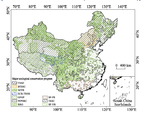
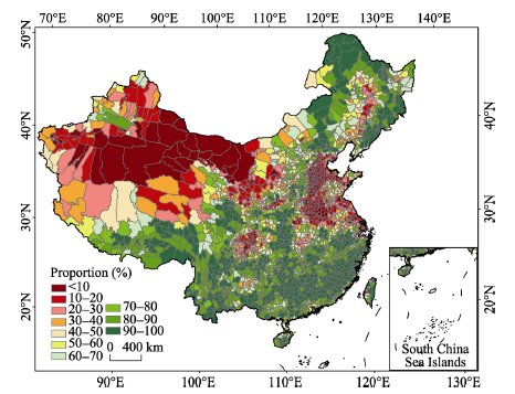
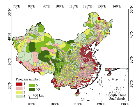
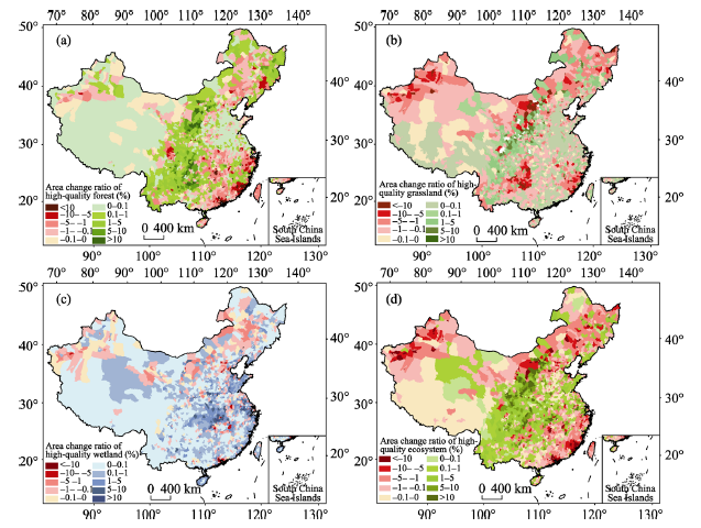
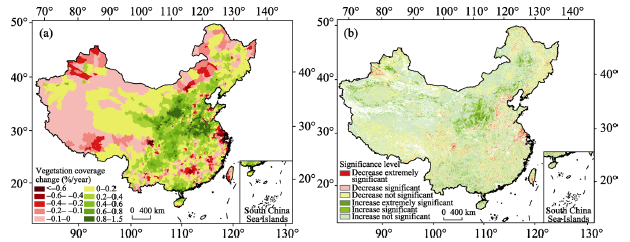
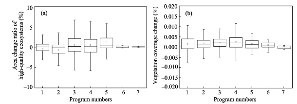
China’s investments, financial incentives and deductions in terms of ecological conservation are based at the county level. Therefore, the monitoring and assessment of the effects of ecological conservation at the county level is important to provide a scientific basis for the assessment of the ecological and environmental quality at the county scale. This paper quantitatively estimated the dynamics of high-quality ecosystems and vegetation coverage over the past 15 years, and their relationships with the number of ecological conservation programs at the county level were analyzed. Then, the effects of ecological conservation measures on ecological changes at the county level and their regional suitability were assessed and discussed. The results showed that counties with a percentage of high-quality ecosystems greater than 50% were primarily distributed in northeastern China, southern subtropical China and the southeastern Qinghai-Tibet Plateau, and those with a percentage lower than 20% were mostly distributed in northwestern China, the southwestern karst region and the North China Plain. In recent decades, ecological conservation has focused on ecologically fragile regions; more than five ecological conservation programs have been implemented in most counties of the Three River Source Region in Qinghai Province, southeastern Tibet, western Sichuan, the Qilian Mountains, southern Xinjiang and other western regions, while only one or zero have been implemented in the eastern coastal area of China. Over the past 15 years, the proportional area of high-quality ecosystems has increased in approximately 53% of counties. The vegetation coverage of counties in the Loess Plateau, Huang-Huai-Hai Plain, Beijing-Tianjin-Hebei (Jing-Jin-Ji), Sichuan-Guizhou-Chongqing, and Guangdong-Guangxi provincial-level areas has increased significantly. However, it decreased in northern Xinjiang, central Tibet, central and eastern Inner Mongolia, the Yangtze River Delta and other regions. The relationships between the numbers of ecological conservation programs and the indicators of ecosystem restoration response, such as high-quality ecosystem and vegetation coverage, do not show positive correlations. These results suggest that ecological conservation programs should be planned and implemented according to the distribution patterns of high-quality ecosystems and that restoration measures such as afforestation should follow natural principles and regional differentiation under the background of climate change.

Cite this article

HUANG Lin , ZHENG Yuhan , XIAO Tong . Regional differentiation of ecological conservation and its zonal suitability at the county level in China[J]. Journal of Geographical Sciences, 2018 , 28(1) : 46 -58 . DOI: 10.1007/s11442-018-1458-0

Ecosystem degradation and biodiversity loss accompanied by industrialization, urbanization and agricultural modernization have attracted widespread attention (Liu and Diamond, 2005; Zhang and Zhao, 2007; Fu, 2010; Liu et al., 2014). To reverse the deterioration of the ecological environment, China began to implement the Three-North Shelter Forest Program (TNSF) in the 1970s, and a series of major ecological protection and construction programs have subsequently been carried out since 2000, such as the Natural Forest Resources Protection (NFRP), Grain for Green Program (GFGP), Shelter Forest in the Yangtze River Basin (SF-YR) and Shelter Forest in the Pearl River Basin (SF-PR), Returning Rangeland to Grassland (RRG), Wetland Conservation (WC), and Wildlife Protection and Nature Reserve Construction (WPNRC). According to statistics, the total investment in ecological programs has been more than 1.3 trillion yuan. With the implementation of the series of ecological programs, the situation of sustained degradation of ecosystems in China has been curbed in some areas, and the ecological environment in the area where the programs have been implemented has significantly improved (SFA-PRC, 2008, 2016a, 2016b), forest area and vegetation coverage have significantly increased (Wang et al., 2010; Li et al., 2012; Huang et al., 2016), degraded grassland has been restored (Liu et al., 2008; Shao et al., 2013; Shao et al., 2017), the expansion rate of desertified land has been effectively controlled (Wang et al., 2004; Zhuo et al., 2007), the area of soil erosion has declined, and the soil and water conservation capacity of some areas experiencing soil erosion has been significantly enhanced (Wang et al., 2012; Deng et al., 2014; Wang et al., 2015). However, China’s ecological deterioration trend has not yet been fundamentally reversed, the contradiction between ecological protection and economic development is still outstanding, and the ecological security situation is still grim (MEP-PRC, 2016).
Since the 1950s, ecological protection measures have been evaluated from the different aspects of ecological, economic and social benefits (Li and Zhai, 2002). In the 1990s, China constructed an evaluation index system for the major ecological programs of the Three-North Shelter Forest Program, Natural Forest Resources Protection, and Grain for Green Program to assess the ecological benefits of programs by applying site monitoring and comparison, remote sensing observation and inversion (SFA-PRC, 2008, 2016a, 2016b). However, due to the lack of long-term temporal and spatial information on ecosystem changes and the integrated technical methods of project monitoring and evaluation, we do not have a quantitative understanding of the ecosystem changes since the implementation of large-scale ecological programs. It is difficult to conduct a quick and scientific evaluation of the ecological effects of the programs, and there is a lack of targeted understanding regarding the project layouts and policy designs of ecological conservation efforts in the future (Shao et al., 2017; MEP-PRC and CAS, 2017). Therefore, there is an urgent need for all kinds of ecological programs to carry out systematic, comprehensive and accurate assessments of the ecological effects through third-party organizations.
However, the planning scope and actual investment of ecological conservation programs have considered the county as the basic unit. Because the spatial distribution of a project is not considered during planning, it is difficult to obtain the specific scope of the program at the macro scale, and it is difficult to distinguish the role of climate change versus the contribution of ecological programs or even the contribution of a certain program in response to regional ecosystem changes. At the same time, the assessment of the performance of local governments in the past only involved Gross Domestic Product (GDP) and did not consider the ecological environment or even simple assessment indicators. In recent years, the ecological GDP or Grass Ecosystem Product have become new measures to evaluate performance, and differential assessment mechanisms have been implemented according to the main functions in terms of impoverished or ecologically fragile or healthy counties (Liu et al., 2011). Many studies have been carried out to evaluate the quality of the ecological environment at the county scale and have attempted to apply such assessments to evaluate performance at the county level (Liu et al., 2010; Liu et al., 2012; Li et al., 2014).
Since 2011, the central government has annually monitored and evaluated the quality of the ecological environment of the counties included in the key ecological function area and reduced or increased their financial transfer payment funds according to the degree of change in the ecological environment (MF-PRC, 2011). Therefore, we need to understand the interannual variability in ecosystem conditions at the county level to improve ecological restoration and ecological conservation programs. At the national or regional scale, what is the regional suitability of ecological conservation programs and measures? Do those programs and measures follow the suitability of the zone? In addition, what problems should be addressed in future program design and the spatial layout and specific implementation of ecological programs? Therefore, determining how to carry out the monitoring and evaluation of ecosystem changes and ecological conservation effects at the county scale has become an urgent problem to be solved. This study can supply the reference method for monitoring and evaluating the quality of the ecological environment at the county scale and provide a scientific basis for the further implementation and continued planning of ecological programs.

1 Data and methods

1.1 Data collection and processing

In this paper, the ecological conservation activities of China mainly refer to the national key ecological programs, which consist of TNSF, NFRP, GFGP, SF-YR, SF-PR, WPNRC, RRG, Beijing and Tianjin Sand Source Control (BTSSC), Ecological Conservation and Restoration in the Three-River Source Region (ECR-TRSR), Tibet Ecological Security Conservation (TESC), and Comprehensive Control of Rocky Desertification in Karst Area (CCRDK). In addition, the national financial transfer payments for ecosystem function conservation areas (EFCAs) were also considered. Figure 1 shows the spatial distribution of these programs at the county scale. The numbers of ecological conservation activities implemented in each county are shown.
The land use and land cover change (LULCC) datasets for China in 2000 and 2015 with a spatial resolution of 100 m were applied (Liu et al., 2014), which were obtained by manual interpretation based on Landsat TM/ETM+ and CBERS (China & Brazil Earth Resource Satellites) images. These datasets were divided into 6 primary land use and land cover types, consisting of cropland, forest land, grassland, wetland, built-up land and unused land. The 6 primary types were further divided into 25 secondary land use and land cover types.
Figure 1 The distribution of ecological conservation programs at the county level in China
Normalized Difference Vegetation Index (NDVI) products from the Moderate-resolution Imaging Spectroradiometer (MODIS) with 1 km spatial resolution from 2000 to 2015 were collected. Sixteen-day NDVI datasets with continuous time series were obtained using the maximum-value composites (MVC) method. The data were processed using mosaics and filtering. It was applied to estimate the vegetation coverage according to the theory of the dichotomous pixel model, which means that the NDVI value of one pixel represents the contribution from the green vegetation and the contribution from the vegetation-free area. The formula is as follows:
\[{{F}_{c}}=\frac{NDVI-NDV{{I}_{soil}}}{NDV{{I}_{veg}}-NDV{{I}_{soil}}} \ \ (1)\]
where Fc is the vegetation coverage, and NDVIveg and NDVIsoil are the NDVI values of the grids full of green vegetation and vegetation-free areas, respectively. The two grids were determined based on the land use and land cover datasets.
Data representing the precipitation, maximum and minimum air temperature, sunshine hours, wind speed at 2 m, and relative humidity observed at 740 national meteorological stations were downloaded from China Meteorological Data Service Center (http://data.cma.cn/), quality controlled and interpolated in a 1 km spatial grid using the ANUSPLIN interpolation method and applying the DEM as a covariate. The potential evapotranspiration was calculated using the FAO56-Penman-Monteith model that was improved in 1998 (Allen et al., 1998), and the wetting index (Im) was calculated based on the Thornthwaite method (Thornthwaite, 1948).
\[{{I}_{m}}=100\times \left( \frac{P}{E{{T}_{0}}}-1 \right) \ \ (2)\]
\[E{{T}_{0}}=\frac{0.408\Delta ({{R}_{n}}-G)+\gamma \frac{900}{T+273}{{U}_{2}}({{e}_{s}}-{{e}_{a}})}{\Delta +\gamma (1+0.34{{U}_{2}})} \ \ (3)\]
where ET0 is the annual potential evapotranspiration (mm), P is the annual total precipitation (mm), Rn is the surface net radiation (MJ·m‒2·d‒1), G is the soil heat flux density (MJ·m‒2·d‒1), T is the daily average temperature (°C), U2 is the wind speed at 2 m (m·s‒1), es and ea are the saturated and actual vapor pressure, respectively (kPa), ∆ represents the slope of the saturated vapor pressure and temperature curve (kPa·°C‒1), and γ is a constant of the wet and dry table (kPa·°C‒1).
According to the range of Im, the climatic zone are divided into arid (Im<-66.7), semi-arid (-66.7<Im<-33.3), semi-humid (-33.3<Im<0), humid (0<Im<20), and moist humid (Im>20).

1.2 Study methods

In this study, the county (city, county, and banner) was applied as the basic evaluation unit. We analyzed the changes in high-quality ecosystem and vegetation coverage at the county scale over the past 15 years and quantitatively determined the changes in ecosystem status. Then, the relationships between the numbers of ecological conservation programs and ecosystem changes were explored. Finally, the regional differentiation in the ecological effectiveness of conservation programs was investigated, and the regional suitability of conservation measures was discussed.
The high-quality ecosystem in this study was defined as including natural forest and plantations with a canopy density of more than 30%, shrubs with a canopy density of more than 40% and a height less than 2 m, grasslands with a coverage of more than 50%, flooded wetlands and inland swamps. Within each county, the percentage of high-quality ecosystems and the percentage of high-quality ecosystem changes over the past 15 years based on the total area of high-quality ecosystems were statistically analyzed. The trends in the change in vegetation coverage during 2000-2015 were analyzed by the least squares method, and the annual rate of change over the past 15 years was statistically analyzed at the county scale.
The significance level of the trends was statistically evaluated using the correlation coefficient. The correlations between the numbers of ecological conservation programs and the proportional area of high-quality ecosystems as well as the annual rate of change in vegetation coverage were determined. Based on the wet index, which reflects changes in water and heat conditions, the regional suitability of afforestation, grassland planting and enclosures in different climate zones was analyzed.

2 Results

2.1 Regional differentiation in high-quality ecosystems at the county scale

The high-quality ecosystems are mainly distributed in the northeastern temperate monsoon climate zone and the southern subtropical regions (Figure 2). In northeastern China, from Xiao Hinggan to the Changbai Mountains, the proportional area of high-quality ecosystems of a county’s total terrestrial area is more than 50% in most counties, with forest coverage over 30%, which forms a natural barrier in this region. In the eastern part of Inner Mongolia located in the south of Da Hinggan, high-quality ecosystems in most counties account for more than 50%, with concentrated forests, a high coverage of grasslands and a large number of wetlands. The middle part of Inner Mongolia is dominated by grasslands with high coverage, and with high-quality ecosystems composing more than 20% of the total area. In northwestern China, which is dominated by low-coverage grasslands and desert, the proportional area of high-quality ecosystems in most counties is less than 20%, and just one-fourth of counties have a percentage of high-quality ecosystems exceeding 20%. Only five of the counties have a percentage of high-quality ecosystems exceeding 50%, mainly forests and high-coverage grassland distributed in the Tianshan Mountains and Qilian Mountains.
Figure 2 The zonal distribution pattern of China's high-quality natural ecosystems
Southern subtropical China is dominated by forests, and more than two-thirds of the counties have a percentage of high-quality ecosystems above 50%. The percentage of high- quality ecosystems in the southwestern karst region was lower, ranging from approximately 10% to 20%. In areas where concentrated forests are distributed in the Qinling-Daba Mountains, southwestern Sichuan and Yunnan provinces, and northern Guangxi Zhuang Autonomous Region, the percentage of high-quality ecosystems is higher, accounting for more than 70% in most of the counties. However, on the North China Plain and in Jiangsu and Zhejiang provinces, the percentages of high-quality ecosystems are almost less than 10% due to the high level of urbanization and rapidly expanding construction land.
On the Qinghai-Tibet Plateau, grasslands are the most typical and widely distributed ecosystems. The number of counties with a percentage of high-quality ecosystems greater than 50% accounted for 86.1%. In particular, a large tract of primeval forests is distributed on the southeastern Tibet Plateau, with the forest coverage rate reaching more than 80%.

2.2 Regional differentiation in ecological conservation at the county scale

Based on the number of ecological conservation programs in each county (Figure 3), we can see that counties with one or fewer programs are mostly distributed in Hebei, Shandong, Jiangsu, Zhejiang, Fujian and other eastern coastal areas. The counties with two programs are concentrated in central China as well as in the northeastern region and Tibet and Xinjiang. The counties with three programs are mainly distributed in western China, especially in southwestern China and on the Loess Plateau. The counties with four programs primarily occur in Inner Mongolia, northern Xinjiang and northern Tibet. The counties with five or more programs are located in the Three-River Source Region, the Qilian Mountains, southeastern Tibet, western Sichuan province, and southern Xinjiang.
Figure 3 The distribution of the number of major ecological conservation programs at the county level in China
China’s ecological conservation measures focus on afforestation, grass planting, enclosures, and others. In terms of spatial distribution, integrated afforestation, grass planting and enclosures were implemented in the eastern and central parts of Inner Mongolia, north of the Tianshan Mountains, the upstream of the Tarim River, the Ordos Plateau, the Heihe River Basin, the Shule River Basin, and the western bank of the Yellow River. Grassland conservation measures of enclosure establishment and rotational grazing were mostly applied in Inner Mongolia, Qinghai, Tibet, Xinjiang and other grassland areas. Afforestation and enclosure measures were widely used in forest nursery areas and GFGP regions.

2.3 The dynamics of high-quality ecosystem and vegetation coverage over recent 15 years

From 2000 to 2015 (Figure 4), the proportional area of high-quality ecosystems in 1512 counties in China increased, especially on the Loess Plateau and in the upper and middle reaches of the Yangtze River Basin. In terms of single ecosystem types, the proportional area of forest increased in 1722 counties, the proportional area of high-coverage grassland increased in 1522 counties, and the proportional area of wetland increased in 2214 counties. The forested area on the Loess Plateau has significantly increased, and the ecological environment changed from “overall deterioration and local improvement” to “overall improvement and local benign cycle”, which indicates the positive effects of the ecological conservation and restoration programs. The area of cultivated land along the upper and middle reaches of the Yangtze River declined; however, the forested area obviously increased, and the wetland area grew slightly, especially in the Three Gorges Reservoir and the Wujiang River Basin.
Figure 4 Proportional change in the area of forest (a), grassland (b), wetland (c) and all high-quality ecosystems (d) at the county level in China during 2000-2015
At the same time, the proportional area of high-quality ecosystems in 1347 counties in China decreased over the past 15 years, especially in northwestern Xinjiang, southeastern coastal regions, northeastern China, and eastern Inner Mongolia. In these regions, the proportional area of forest decreased in 1137 counties, the proportional area of high-coverage grassland decreased in 1337 counties, and the proportional area of wetland decreased in 645 counties. Urbanization in the southeastern coastal regions has led to a decline in the area of forest and grassland. The area of forest has significantly increased in northwestern Xinjiang, central and eastern Inner Mongolia, and northeastern China, but the area of grassland and wetland has obviously decreased, which has resulted in a decrease in the percentage of high-quality ecosystems. In terms of the background climate, those changes in area are not conducive to upgrading the region’s ecosystem quality and service capacity.
From 2000 to 2015, the changes in vegetation coverage at the county level in China showed significant regional differentiation (Figure 5). The vegetation coverage increased significantly in the counties of the Loess Plateau, Huang-Huai-Hai Plain, Beijing-Tianjin-Hebei, and Sichuan-Guizhou-Chongqing, and Guangdong-Guangxi provincial-level areas. Among them, the increasing trend in vegetation coverage is most obvious in the Loess Plateau and is particularly significant in the Qinling-Daba Mountains and the Funiu Mountains, with annual increasing rates of 0.8% to 1.5%. It also showed a more obvious upward trend in the Huang-Huai-Hai Plain, Yimeng Mountains and Dabie Mountains, with annual increases of approximately 0.4% to 0.8%. In contrast, the decline in vegetation coverage was mainly concentrated in the counties of northern Xinjiang, central Tibet, central and eastern Inner Mongolia and other arid and semi-arid regions, and the urban expansion area of the Yangtze River Delta. In the northern part of Xinjiang and central and eastern Inner Mongolia, the vegetation coverage decreased by more than 0.6%. Due to the high level of urbanization in recent years, vegetation coverage in the middle and lower reaches of the Yangtze River also showed a decreasing trend, especially in the Yangtze River Delta and Hunan, Jiangxi and Zhejiang provinces.
Figure 5 Changes in vegetation coverage (a) and its significance level (b) at the county scale in China during 2000-2015

2.4 Regional suitability of ecological conservation at the county scale

The relationships between the number of ecological conservation programs and the changes in ecological indicators (Figure 6) show that the proportional change in area of high-quality ecosystems of the total area of high-quality ecosystems in a county is higher in the counties that implemented three to five ecological conservation programs; however, it was relatively lower in counties that had implemented fewer than three or more than five programs. In particular, the increasing trend of the annual average vegetation coverage is the highest in the counties where four ecological conservation programs had been implemented. The larger the number of programs, the more the vegetation coverage had declined. Therefore, there was no positive correlation between the number of programs and improvement in ecological status based on high-quality ecosystems and vegetation coverage.
Figure 6 The relationships between the number of ecological conservation programs and the changes in high-quality ecosystems (a) and vegetation coverage (b)
Climate change and ecological conservation simultaneously affect regional ecosystem changes, of which the former is the most important. Therefore, ecological conservation measures need to adapt to the regional background climate. Inappropriate measures have negative impacts on regional ecosystems. Taking the arid oasis in the Shule River Basin, in the northern foot of the Tianshan Mountains and the upper reaches of the Tarim River, as an example, due to its relatively high amounts of alpine ice and snow melt water, the ecosystem is dominated by low- and medium-coverage grassland, and the counties have implemented more than three ecological conservation programs. Grassland conservation has had a small effect; however, afforestation has not changed the ecological degradation situation and has even led to further deterioration (Figure 7).
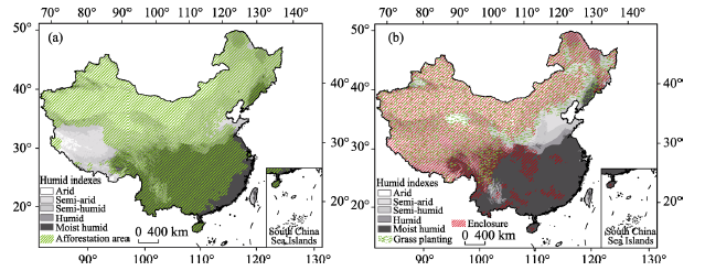
Figure 7 The distribution of afforestation (a) and grass planting and enclosures (b)

3 Discussion and conclusions

In this paper, the role of ecological conservation programs in ecosystem changes at the county scale in China was evaluated by analyzing changes in high-quality ecosystems and vegetation coverage over the last 15 years. The results show that there are no positive correlations between the number of ecological conservation programs and the improvement of indicators of ecological status. First, there are zonal differences in the distribution of high-quality ecosystems in China. The percentages of high-quality ecosystems are greater than 50% in northeastern China, the southern subtropical zone and the southeastern Qinghai-Tibet Plateau. However, the percentages are lower than 20% in northwestern China, the southwestern karst zones, and the North China Plain. Second, the ecological conservation programs in recent decades have mostly been implemented in the typical ecologically fragile areas, such as the TRSR, southeastern Tibet, western Sichuan, the Qilian Mountains, and southern Xinjiang, where an average of nearly five programs have been implemented at the county scale. Over the past 15 years, the proportional area of high-quality ecosystems increased in approximately 53% of China’s counties. The vegetation coverage at the county scale increased significantly in the Loess Plateau, Huang-Huai-Hai Plain, Beijing-Tianjin-Hebei, and Sichuan-Guizhou-Chongqing, and Guangxi-Guangdong provincial-level areas. However, the vegetation coverage has declined in northern Xinjiang, central Tibet, central and eastern Inner Mongolia, and the Yangtze River Delta, indicating that climate change plays a leading role among the factors affecting regional ecosystem changes (Yue et al., 2013; et al., 2015).Therefore, ecological conservation should first consider the distribution pattern of high-quality ecosystems, and project measures, such as afforestation, should follow the laws of nature under the background of climate change.
Future ecological conservation programs should first determine the spatial scope needed for conservation and restoration at the macro level to carry out unified program planning and project implementation according to the laws of regional differentiation and the regional suitability based on the distribution of ecosystems in China to reduce unwanted program duplication or dispersion. Targeted conservation should be designed for different regions. For counties with a proportional area of high-quality ecosystems greater than 50%, the main task is to protect high-quality ecological resources and to give priority to the implementation of ecological compensation while taking into account the effects of long-term ecological conservation. For counties in which high-quality ecosystems have significantly increased after the implementation of ecological conservation programs or in which ecological degradation has been effectively curbed, conservation programs should focus on the consolidation of the effects of long-term ecological conservation by investing fixed funds and implementing regular monitoring and evaluation and then taking into account the protection of high-quality ecosystems. For counties with several ecological conservation programs but fewer ecological effects and the need for further improvement, we should avoid the problems of dispersing the implementation of multiple ecological conservation programs and promote the integration of multiple programs in planning to integrate and enhance those scattered programs with limited effectiveness and combine various funds to improve the efficiency of capital.
In the process of the allocation of ecological conservation funds from the central government to local financial departments, on the one hand, in order to balance the relationships between the parties, the provincial finance departments tend to reallocate the funds, resulting in the reduction of funds for some of the counties. On the other hand, there are problems in expanding fund use, undefined compensation policies, and departmental apportionment in some areas, thus greatly reducing the efficiency of the use of compensatory funds and resulting in no obvious effects. In addition, the percentage of transfer payment funds used for ecological conservation is lower in counties. When using the funds, most local governments focus on the local financial gap and population and do not have enough funds for ecological conservation. Therefore, the mechanism used to evaluate the performance of a county’s government needs to be linked with the effectiveness of ecological conservation. Based on the monitoring and assessment of the effects of ecological conservation at the county scale, scientific incentive, reward and punishment mechanisms should be established to assess the input of funds and their ecological benefits for ecological conservation.
In this study, the effects of ecological conservation were assessed at the county scale using the indexes of high-quality ecosystem and vegetation coverage, which can provide a scientific basis for the assessment of a county’s ecological environment, the approval of ecological protection funds, and the planning and implementation of ecological conservation programs. Our study differs from the qualitative assessment of performance based on ecological GDP or GEP (Liu et al., 2011) and differs from the quantitative description of graded evaluation using a single index (Liu et al., 2010; Liu et al., 2012). It also differs from a comprehensive evaluation, which may mask the actual effects (Li et al., 2014). The uncertainties of this study are mainly reflected in two aspects: 1) the definition and classification of high-quality ecosystems. For example, commercial plantations, such as eucalyptus, rubber and other economic forests, have the characteristics of high resource consumption and disturbance of the ecosystem through management but have lower ecological effects, so they should not be classified as high-quality ecosystems. However, because of the difficulties of acquiring spatial information, they were not considered in this study. 2) It is difficult to identify which specific programs increased or decreased ecological effects at the county scale based on facilitation or stress. Which ecological conservation programs have positive effects, and which are ineffective? Which programs can be combined to produce significant ecological effects? Such questions require us to further discuss the effectiveness of specific programs by combining different methods.

The authors have declared that no competing interests exist.

[1]
Allen R G, Pereira L S, Raes Det al., 1998. Crop Evapotranspiration: Guidelines for Computing Crop Water Requirements. FAO Irrigation and Drainage Paper 56. Rome: United Nations Food and Agriculture Organization, 15-86.Page 1. AB.W 1 Crop evapotranspiration - Guidelines for computing crop water requirements -FAO Irrigation and drainage paper 56 By Richard G. Allen Utah State University Logan, Utah,USA Luis S. Pereira Instituto Superior de Agronomia Lisbon, Portugal

[2]
Deng L, Liu G B, Shangguan Z P, 2014. Land-use conversion and changing soil carbon stocks in China’s ‘Grain-for-Green’ Program: A synthesis.Global Change Biology, 20(11): 3544-3556.Abstract <p>The establishment of either forest or grassland on degraded cropland has been proposed as an effective method for climate change mitigation because these land use types can increase soil carbon (C) stocks. This paper synthesized 135 recent publications (844 observations at 181 sites) focused on the conversion from cropland to grassland, shrubland or forest in China, better known as the ‘Grain-for-Green’ Program to determine which factors were driving changes to soil organic carbon (SOC). The results strongly indicate a positive impact of cropland conversion on soil C stocks. The temporal pattern for soil C stock changes in the 0–10002cm soil layer showed an initial decrease in soil C during the early stage (502years) coincident with vegetation restoration. The rates of soil C change were higher in the surface profile (0–2002cm) than in deeper soil (20–10002cm). Cropland converted to forest (arbor) had the additional benefit of a slower but more persistent C sequestration capacity than shrubland or grassland. Tree species played a significant role in determining the rate of change in soil C stocks (conifer

DOI PMID

[3]
Fu B J, 2010. Trends and priority areas in ecosystem research of China.Geographical Research, 29(3): 383-396. (in Chinese)Ecosystem research has experienced important progress since the beginning of the 21st century.A series of hot scientific themes have aroused much attention of the academic realm such as biodiversity and ecosystem functioning,ecosystem management,ecological risks and ecological security,the ecological responses and effects of global change.The general trend of contemporary ecological research is multidimensional and can be summarized as deepening the scientific understanding on ecological mechanisms,ecosystem monitoring and modeling across spatiotemporal scales,integrative ecosystem assessment and management with consideration of both socioeconomic and biophysical factors.The socioeconomic development in China is faced with serious challenges for the limited natural resource reserve and disturbing environmental problems.In response to these challenges,large scale ecological conservation and restoration projects have already been implemented across the country,for which many scientific questions in ecosystem research are urgently needed for resolution.This paper proposed some priority areas and important directions for ecosystem science in China based on the integrative analysis of the trends and frontiers of international level ecological research and the practical needs for the relationship between environmental and development in China.

DOI

[4]
Huang L, Cao W, Gong G Let al., 2016. Spatial and temporal variations in ecosystems in the three northern regions of China, 2000-2010.Acta Ecologica Sinica, 36(1): 107-117. (in Chinese)This study analyzed the ecosystem macrostructure,quality,and key services and their driving forces in the three northern regions( northeastern,northwestern,and northern) of China,in the first 10 years of the 21 stCentury. The results showed that( 1) during 2000-2010,forestland area increased by 10,300 km2; grassland decreased by 900 km2; wetland area decreased by 33. 9 km2; farmland increased by 1900 km2; artificial coverage increased by 12400 km2; and other ecosystems decreased by 23700 km2 in the three northern regions.( 2) The normalized difference vegetation index( NDVI),leaf area index( LAI),and aboveground vegetation productivity in these regions increased slightly over the past10 years,especially in the Loess Hilly Region. However,the vegetation coverage decreased slightly.( 3) The soil erosion modulus per unit area decreased by 27. 25% in the three northern regions,with an annual reducing rate of 1. 13 t / hm2.The amount of sand-fixing services was low because the force of wind erosion decreased annually,suggesting that a reduced force in wind erosion decreases the amount of soil erosion. In soil water erosion zones of the three northern regions,the soil water erosion modulus showed a slight increasing trend in the past 10 years,whereas the modulus in the Loess Plateau and sand areas showed decreasing trends. The amount of ecosystem soil conservation service per unit area showed an increasingtrend,with an annual increasing rate of 0. 28 t / hm2,indicating improved soil conservation capacity.( 4) The temperature increased by 0. 02 / a,and precipitation increased by 3. 00 mm / a in the past 10 years in the three northern regions,and the moderate warming and increased precipitation were useful for vegetation recovery. The human disturbance index showed decreasing trends in Loess Plateau and in the agricultural areas of Northeast and North Plain,indicating that the effect of human disturbances on natural ecosystems has been suppressed in these two regions.

DOI

[5]
Li G P, Liu Q, Zhang W Bet al., 2014. Transfer payment system in the national key ecological function area and the ecological environmental quality: Empirical study based on the countryside data of Shaanxi Province.Journal of Xi’an Jiaotong University, 34(2): 27-31. (in Chinese)The policy target of the transfer payment measures for the national key ecological function area is to improve people's livelihood and to protect the ecological environmental quality. Taking the sample data from 2009 to 2011 of 37 counties that are granted the transfer payment as an example,the paper makes an empirical confirmation of the relation between the Chinese countywide environmental quality and state key ecological function area transfer payment fund. The results show that the increase in the transfer payment is able to propel the improvement of the ecological environmental quality of the state key ecological function area,but this change is relatively weak. In the later stage,it is still mandatory to raise the protection efficiency of the transfer payment for the state key ecological function area by taking measures such as moderating the methods and changing the concepts,etc.

[6]
Li S D, Zhai H B, 2002. The comparison study on forestry ecological projects in the world.Acta Ecologica Sinica, 22(11): 1976-1982. (in Chinese)The basic conditions of more than 20 famous forestry ecological projects in the world are introduced, and among them, the 11 important projects are analyzed on scale, scope, investment, period and start\|up time (means the period from initiation to now) in single factor and multi\|factors using Analytic Hierarchy Process (AHP). The results using AHP shows that the 10 largest forest ecological projects in the world are: Chinese Three\|north and Middle and Lower Reaches of the Yangtze River Shelter\|belt Forest Development Project(TNYR), Chinese Natural Forest Protection Project(NFP), Chinese Conversion Croplands into Forests Project(CCF), Chinese Wildlife Conservation and Nature Reserve Development Project(WCNR), American Roosevelt Project(RS), former Soviet Stalin Rebuild Nature Plan(SRN), Canadian Green Plan(GP), Japanese Combating Mountains Plan(CMP), the Green Dam Project of the Five Countries in northern Africa(GDFC) and Chinese Fast\|growing and High\|yielding Timber Forest Development Project(FHTF). The result using single factor comparison indicate that the scale and scope of six Chinese projects are larger and investment was higher than those of foreign five ones. The period and start\|up time of foreign great Projects are longer than those of Chinese ones except TNYR. The start\|up time of Chinese great projects (not including TNYR) is from 1 year to 4 years, and that of foreign ones at least 12 years, generally more than 30 years, even up to 67 years. The result shows the strength and resolution that Chinese government thoroughly improve ecology environment. At the same time, it indicates that Chinese forestry ecology construction is just starting, and has more work to do. The development of Chinese and foreign forestry ecological projects is basically similar. This shows that the desire of people thirsting for good nature and environment is accordant as well as the ways of forestry ecological projects construction, in spite of the difference of countries and cultures. Compared with foreign forestry ecological projects, Chinese ones have their own features. The NFP is the important contribution of Chinese government to world ecology construction, and the model of combining combat with protection, which won extensive praise in the world. There are 1.3 billion people in China, and about 0 8 billion people are farmer. In order to improve ecology and bring benefits to offspring, Chinese government offers 300 billion RMB yuan to realize the CCF, which is unique in the history of foreign important ecological projects. The FHTF will thoroughly solve the problem of Chinese timber shortage, and is the only Project combining ecological projects with industry development. Those are enough to indicate the strength and verve that our government combats environment.

DOI

[7]
Li S S, Yan J P, Wan J, 2013. Response of vegetation restoration to climate change and human activities in Shaanxi-Gansu-Ningxia Region.Journal of Geographical Sciences, 23(1): 98-112.The "Grain for Green Project" initiated by the governments since 1999 were the dominant contributors to the vegetation restoration in the agro-pastoral transitional zone of northern China. Climate change and human activities are responsible for the improvement and degradation to a certain degree. In order to monitor the vegetation variations and clarify the causes of rehabilitation in the Shaanxi-Gansu-Ningxia Region, this paper, based on the MODIS-NDVI and climate data during the period of 2000 2009, analyzes the main charac-teristics, spatial-temporal distribution and reasons of vegetation restoration, using methods of linear regression, the Hurst Exponent, standard deviation and other methods. Results are shown as follows. (1) From 2000 to 2009, the NDVI of the study area was improved progres-sively, with a linear tendency being 0.032/10a, faster than the growth of the Three-North Shelter Forest Program (0.007/10a) from 1982 to 2006. (2) The vegetation restoration is characterized by two fast-growing periods, with an "S-shaped" increasing curve. (3) The largest proportion of the contribution to vegetation restoration was observed in the slightly improved area, followed by the moderate and the significantly improved area; the degraded area is distributed sporadically over southern part of Ningxia Hui Autonomous Region as well as eastern Dingbian of Shaanxi province, Huanxian and Zhengyuan of Gansu province. (4) Climate change and human activities are two driving forces in vegetation restoration; more-over anthropogenic factors such as "Grain for Green Project" were the main causes leading to an increasing trend of NDVI on local scale. However, its influencing mechanism remains to be further investigated. (5) The Hurst Exponent of NDVI time series shows that the vegetation restoration was sustainable. It is expected that improvement in vegetation cover will expand to the most parts of the region.

DOI

[8]
Liu H J, Zhang J H, He L Het al., 2010. Analysis of the status and spatial distribution patterns of county-level eco-environmental quality of China.Environmental Monitoring of China, 26(6): 62-65. (in Chinese)In the present work,we collected county-level data of 2008 of the 31 provinces in China,calculated county eco-environmental quality(EQ) index according to Technical Criterion for Eco-environmental Status Evaluation and analyzed the spatial distribution patterns of different types of eco-environmental quality.The results indicated that good and common was the two main EQ types,which covered 72% of China terrestrial area.Counties Q in Eastern Region was better than that in Middle and Western Region.good was the dominant type in Middle Region,whereas common in Western Region.Climate and landform is the main factor of affecting county EQ spatial distribution pattern.

DOI

[9]
Liu J, Diamond J, 2005. China’s environment in a globalizing world.Nature, 435(7046): 1179-1186.How China and the rest of the world affect each other.

DOI PMID

[10]
Liu J Y, Kuang W H, Zhang Z Xet al., 2014. Spatiotemporal characteristics, patterns, and causes of land-use changes in China since the late 1980s.Journal of Geographical Sciences, 24(2): 195-210.Land-use/land-cover 变化(LUCC ) 有连接到人和自然相互作用。瓷器 Land-Use/cover 数据集(CLUD ) 从 1980 年代末在 5 年的间隔定期被更新到 2010,与基于 Landsat TMETM+ 图象的标准过程。陆地使用动态区域化方法被建议分析主要陆地使用变换。在国家规模的陆地使用变化的空间与时间的特征,差别,和原因然后被检验。主要调查结果如下被总结。越过中国的陆地使用变化(LUC ) 在最后 20 年(19902010 ) 里在空间、时间的特征显示了一个重要变化。农田变化的区域在南方减少了并且在北方,而是仍然是的全部的区域增加了几乎未改变。回收农田从东北被转移到西北。布满建筑物陆地很快膨胀了,主要在东方被散布,并且逐渐地展开到中央、西方的中国。树林首先减少了,然后增加但是荒芜的区域是反面。草地继续减少。在中国的 LUC 的不同空间模式被发现在之间迟了第 20 世纪并且早第 21 世纪。原版 13 个 LUC 地区在一些地区被边界的变化由 15 个单位代替。包括的这些变化(1 ) 的主要空间特征加速的扩大布满建筑物在 Huang-Huai-Hai 区域,东南的沿海的区域,长江的中流区域,和四川盆登陆;(2 ) 从东北中国和东方内部蒙古在北方转移了陆地开垦到绿洲在西北中国的农业区域;(3 ) 从在到稻的东北中国的喂雨的农田的连续转变回答;并且(4 ) 为在内部蒙古,黄土高原,和西南的多山的区域的南部的农业牧剧的交错群落的格林工程的谷物的有效性。在最后二十年,尽管在北方的气候变化在农田影响了变化,政策规定和经济驱动力仍然是越过中国的 LUC 的主要原因。在第 21 世纪的第一十年期间,在陆地使用模式驾驶了变化的人为的因素从单程的陆地开发转移了强调到开发和保存。动态区域化方法被用来在单位的 zoning 边界,地区的内部特征,和生长和减少的空间17

DOI

[11]
Liu J Y, Xu X L, Shao Q Q, 2008. Grassland degradation in the “Three-River Headwaters” region, Qinghai Province.Journal of Geographical Sciences, 18(3): 259-273.

DOI

[12]
Liu R, Wang S X, Zhou Yet al., 2012. Ecological environment condition evaluation mode of county region based on remote sensing techniques.China Environmental Science, 32(1): 181-186. (in Chinese)A new ecological environment condition evaluation model of county region based on remote sensing techniques only was proposed.In this model,the classification method based on support vector machines with an HJ-1 CCD image of Qinnan district,Guangxi province was used for extraction of land use data.Indices of biodiversity,vegetation coverage,water density,soil erosion and human activities were extracted and the weighted sums of them were composed of regional ecological index which was used to evaluate the regional eco-environmental quality.Overall ecological environment was relatively good.Area in good land accounted for 64.105% of Qinnan district,which mainly distributed in forest area;31.206% of the whole district belonged to moderate grade which distributed in areas with rich water resources;poor land accounted for 3.668% which distributed in building areas.

[13]
Liu Y S, Liu Y, Chen Y F, 2011. Territorial multi-functionality evaluation and decision-making mechanism at county scale in China.Acta Geographica Sinica, 66(10): 1379-1389. (in Chinese)Territorial function in various regions has a significant spatial heterogeneity and temporal variability.With the rapid development of industrialization and urbanization as well as enhancement of geographic differentiation and diversity of man-earth areal system,territorial functions and regional development orientations has shown an increasingly strong trend towards diversification.Based on the definition of territorial dominant functions at the county level and the building of multi-functionality evaluation index system and index analysis model,this paper evaluates and grades the functions of economic development,food security,social stability,environmental protection and comprehensive function.The results are obtained as follows economy-oriented functional areas are mainly distributed in eastern coastal developed areas and peripheral areas of the metropolitan regions,such as Pearl River Delta,Yangtze River Delta and Beijing-Tianjin-Ji region.Grain-oriented functional areas are mainly distributed in the Northeast China Plain,the Huang-Huai-Hai Plain,Sichuan Basin,central Hubei,eastern Hunan and other regions covered by a large area of plain.The social security function indexes are gradually weakened from coastal to inland areas and from north to south;Eco-conservation areas are concentrated in the Northeast China and southern Qinling Mountain-Huaihe River Line.Then based on the coupling of each dominant function and the evaluation of composite function at the county level,study areas are divided into two types:areas with strong function and areas with weak function.Finally,this paper explores the innovation mechanisms and favorable policies to enhance the dominant function of each county and optimize the allocation of production factors,including the financial transfer payment,ecological compensation,and government performance assessment,which provide a scientific guidance for regional harmony development and sustainable growth of county competitive power.

DOI

[14]
Y, Zhang L, Feng Xet al., 2015. Recent ecological transitions in China: Greening, browning, and influential factors.Scientific Reports, 5(1): 8732.Abstract Ecological conservation and restoration are necessary to mitigate environmental degradation problems. China has taken great efforts in such actions. To understand the ecological transition during 2000-2010 in China, this study analysed trends in vegetation change using remote sensing and linear regression. Climate and socioeconomic factors were included to screen the driving forces for vegetation change using correlation or comparative analyses. Our results indicated that China experienced both vegetation greening (restoration) and browning (degradation) with great spatial heterogeneity. Socioeconomic factors, such as human populations and economic production, were the most significant factors for vegetation change. Nature reserves have contributed slightly to the deceleration of vegetation browning and the promotion of greening; however, a large-scale conservation approach beyond nature reserves was more effective. The effectiveness of the Three-North Shelter Forest Program lay between the two above approaches. The findings of this study highlighted that vegetation trend detection is a practical approach for large-scale ecological transition assessments, which can inform decision-making that promotes vegetation greening via proper socioeconomic development and ecosystem management.

DOI PMID

[15]
Ministry of Environmental Protection of the People’s Republic of China(MEP-PRC), 2016. The 13th Five-Year Planning Outline of National Ecological Protection. (in Chinese)

[16]
Ministry of Environmental Protection of the People’s Republic of China (MEP-PRC),Chinese Academy of Sciences (CAS), 2017. Investigation and Assessment of National Ecological Environment by Remote Sensing for Ten Years from 2000 to 2010. Beijing: Science Press. (in Chinese)

[17]
Ministry of Finance of the People’s Republic of China (MF-PRC), 2011. Notice on the Issuance of the Transfer Payment Method for National Key Ecological Function Areas. (in Chinese)

[18]
Shao Q Q, Fan J W, Liu J Yet al., 2017. Effects of an ecological conservation and restoration project in the Three-River Source Region, China.Journal of Geographical Sciences, 27(2): 183-204.The first-stage of an ecological conservation and restoration project in the Three-River Source Region (TRSR), China, has been in progress for eight years. However, because the ecological effects of this project remain unknown, decision making for future project implementation is hindered. Thus, in this study, we developed an index system to evaluate the effects of the ecological restoration project, by integrating field observations, remote sensing, and process-based models. Effects were assessed using trend analyses of ecosystem structures and services. Results showed positive trends in the TRSR since the beginning of the project, but not yet a return to the optima of the 1970s. Specifically, while continued degradation in grassland has been initially contained, results are still far from the desired objective, ‘grassland coverage increasing by an average of 20%–40%’. In contrast, wetlands and water bodies have generally been restored, while the water conservation and water supply capacity of watersheds have increased. Indeed, the volume of water conservation achieved in the project meets the objective of a 1.32 billion m 3 increase. The effects of ecological restoration inside project regions was more significant than outside, and, in addition to climate change projects, we concluded that the implementation of ecological conservation and restoration projects has substantially contributed to vegetation restoration. Nevertheless, the degradation of grasslands has not been fundamentally reversed, and to date the project has not prevented increasing soil erosion. In sum, the effects and challenges of this first-stage project highlight the necessity of continuous and long-term ecosystem conservation efforts in this region.

DOI

[19]
Shao Q Q, Liu J Y, Huang Let al., 2013. Integrated assessment on the effectiveness of ecological conservation in Sanjiangyuan National Nature Reserve.Geographical Research, 32(9): 1645-1656. (in Chinese)Sanjiangyuan,located in Qinghai Province,is known as the water tower of China.This paper assessed the ecological effectiveness of those projects in Sanjiangyuan,through comparisons of ecological macrostructure,soil erosion and conservation,and grassland production before and after the projects.The natural and human driving factors for effectiveness were also analyzed.The results showed that land cover change index increased obviously,which represented the ecosystem restoration in Sanjiangyuan National Nature Reserves.The increased grassland net primary production and expanded water area were helpful to supply enough food and water to wildlife.Moreover,the declining trends of forest area were restrained in forest related nature reserves.In wetland related nature reserves,wetland area was increased.In grassland related reserves,decreasing trends of grassland and enlarging desertification were also restrained,and wetland expansion and increasing vegetation cover were obvious.In glacier related reserves,retreating glacier and thawing permafrost results to increasing water were useful to vegetation growth;however,it is uncertain in the long term.

DOI

[20]
State Forestry Administration of the People’s Republic of China (SFA-PRC),2008. Development report of the Three-North Shelter Forest System in the Past 30 Years (1978-2008). Beijing: China Forestry Publishing House. (in Chinese)

[21]
State Forestry Administration of the People’s Republic of China (SFA-PRC), 2016a. National Report on Ecological Benefit of Grain for Green Program (2015). Beijing: China Forestry Publishing House. (in Chinese)

[22]
State Forestry Administration of the People’s Republic of China (SFA-PRC), 2016b. National Report on Ecological Benefit of Natural Forest Resources Protection Program in Key State-owned Forest Area in Northeast China and Inner Mongolia (2015). Beijing: China Forestry Publishing House. (in Chinese)

[23]
Thornthwaite C, 1948. An approach toward a rational classification of climate.Geographical Review, 38(1): 55-94.

[24]
Wang B, Zhang G H, Liu G Bet al., 2012. Ecological and environmental evaluation for water and soil loss comprehensive harness in loess hilly region.Transactions of the Chinese Society of Agricultural Engineering, 28(20): 150-161. (in Chinese)

[25]
Wang L, Fu B J, Lv Y Het al., 2010. Spatio-temporal variations of vegetation cover in northern Shaanxi province under the background of ecological restoration.Chinese Journal of Applied Ecology, 21(8): 2109-2116. (in Chinese)

[26]
Wang S, Fu B J, Piao S Let al., 2015. Reduced sediment transport in the Yellow River due to anthropogenic changes.Nature Geoscience, 9: 38-41.

[27]
Wang T, 2004. Progress in sandy desertification research of China.Journal of Geographical Sciences, 14(4): 387-400.

[28]
Yue T X, Zhao N, Ramsey R Det al., 2013. Climate change trend in China, with improved accuracy.Climatic Change, 120(1): 137-151.

[29]
Zhang Y M, Zhao S D, 2007. The condition and trends of the world’s ecosystems.Advances in Earth Science, 22(4): 403-409. (in Chinese)

[30]
Zhuo L, Cao X, Chen Jet al., 2007. Assessment of grassland ecological restoration project in Xilin Gol Grassland.Acta Geographica Sinica, 62(5): 471-480. (in Chinese)

Outlines

/