Research Articles

Spatial difference and mechanisms of influence of geo-economy in the border areas of China

  • SONG Tao , 1, 2, 3 ,
  • CHENG Yi , 1, 2, 4, * ,
  • LIU Weidong 1, 2 ,
  • LIU Hui 1, 2, 4
Expand
  • 1. Key Laboratory of Regional Sustainable Development Modeling, CAS, Beijing 100101, China
  • 2. Institute of Geographic Sciences and Natural Resources Research, CAS, Beijing 100101, China
  • 3. Collaborative Innovation Center for Geopolitical Setting of Southwest China and Borderland Development, Kunming 650500, China
  • 4. College of Resources and Environment, University of Chinese Academy of Sciences, Beijing 100049, China

Author: Song Tao (1983-), PhD, specialized in geopolitics and regional sustainable development. E-mail:

Received date: 2017-03-12

  Accepted date: 2017-05-10

  Online published: 2017-12-10

Supported by

National Natural Science Foundation of China, No.41701131, No.41530634

Key Consulting Project of the Chinese Academy of Science and Technology Strategic Consulting, No.Y02015001

Funding of Institute of Geographic Sciences and Natural Resources Research, CAS, No.Y55R1203YZ

Copyright

Journal of Geographical Sciences, All Rights Reserved

Abstract

Border areas are both important territorial security barriers and portals to the outside world. Considering the complicated geopolitical environment of China’s inland borders, analysis of the current status and mechanisms of influence of geo-economy in border areas is of great significance. Namely, this analysis is important towards leveraging traditional advantages to accelerate China’s development in border and minority areas. Based on a comprehensive analysis, our study constructed a framework to analyze the geo-economy in border areas, and also introduced three indexes: local economy, export-oriented economy and local development. In addition, our study systematically described geo-economic evolution in the border areas of China. We also analyzed the mechanism of geo-economic spatial differentiation in these border areas by using geographical detectors. Our results indicated that the level of geo-economic influence in border areas has grown steadily with significant spatial differentiation. The absolute geo-economic dominance of Northeast China gradually declines over time. Areas with geo-economic advantages are highly dispersed, showing a spatial polarization pattern with several polar nuclei including Mudanjiang city (Northeast China), Baotou city (Inner Mongolia), Bortala Mongol Autonomous Prefecture (Xinjiang), Dehong Dai and Jingpo Autonomous Prefecture and the city of Chongzuo (Yunnan-Guangxi area). Geo-economics in border area is mainly influenced by national policies, the development level of neighboring countries, as well as the desire of these countries to cooperate with China in bilateral trade. Favorable policies, traffic, cultural proximity and other factors also impact the geo-economics of border areas significantly. The Inner Mongolia and Tibet areas are mainly influenced by neighboring countries, while Northeast China and Xinjiang are mainly affected by Chinese policies; the Yunnan-Guangxi area is influenced by a combination of these factors. At the end of the study, we provide our recommendations for developing policies that further geo-economic advantages in complex geopolitical environments and in areas with varied development.

Cite this article

SONG Tao , CHENG Yi , LIU Weidong , LIU Hui . Spatial difference and mechanisms of influence of geo-economy in the border areas of China[J]. Journal of Geographical Sciences, 2017 , 27(12) : 1463 -1480 . DOI: 10.1007/s11442-017-1447-8

1 Introduction

For any country, border areas are both important barriers for territorial security and portals to the outside world. With shifts in world order and the emerging power of globalization, China’s administrative divisions in border areas are pivotal to geopolitical territorial disputes as well as geopolitical cooperation (Lu and Du, 2013). The socio-economic development and territorial security of border areas have increasingly become prominent issues of human geography and geopolitics, among other disciplines of research (Newman and Paasi, 1998). China has a land border of 22,000 kilometers, encompassing 14 countries including Russia, Mongolia, Kazakhstan, India, and Myanmar. In general, these countries are geopolitically complicated, highly fragmented, and vastly different in terms of economic development as well as political system and ideology. Wrestling in border areas is central to displays of power and a key area for China’s contemporary geopolitical strategy (Song et al., 2016). Meanwhile, the border provinces located in the central and western regions as well as Northeast China are generally characterized as “ethnic minority areas, border areas and impoverished areas”. Territorial and national power in the geopolitical perspective is always a critical aspect of border research. Since the start of the 21st century, border research has developed the essence of critical geopolitics and humanistic geopolitics, and gradually strengthened reflection on border environments and social governance. Border areas have become classic cases used in research studying spatial changes and their influence (Tang et al., 2016). Scholars have examined the process of opening and developing border areas from the aspects of economic and trade industries, population migration, and border security, with a particular focus on national interests in border security and development (Su, 2013; Luo and Li, 2010). In general, the research described above delineates the structural characteristics of economic, social, and cultural development in border areas, with special attention given to the discussion of patterns found across individual cases. However, it is still rare to find discussions surrounding spatial pattern and distribution difference of China’s land border areas from a macroscopic point of view. In particular, research is still lacking on the “One Belt, One Road” and “Opening-up the Borders” policies in border areas.
Since the end of the Cold War, geopolitics has been redirected from spatial conflicts and power balance to geo-economics instead (Parker, 1998; Nye, 2004; Song et al., 2016). Geo-economic theory is an interdisciplinary principle that combines geographical, political economic and economic theories. It seeks the greatest benefits for countries by studying the interactions between politics and economy within a specific spatial scope (Gao, 2008; Yu and Fan, 2009; Xiong and Wang, 2012). It was originally proposed by Edward N. Luttwak (Luttwak, 1990), an American scholar, who has emphasized the presence of economic activities under the influence of geographical factors. During the development of geo-economics, various schools of thought representing different nations’ characteristics gradually formed: American schools emphasized market control and economic competition; Russian schools focused on research of the nation’s strategies; Italian schools concentrated on international competition and cooperation (Li et al., 2014). Although the focuses are different, the different schools of thought all arrive at a common post-Cold War consensus: in sharp contrast to “fighting, controlling and containment” during the Cold War, the era of geo-economics proposed “opening, collaboration, win-win, development” as the consensus. The post-Cold War era of geo-economics emphasized international dialogue as well as collaboration in broad fields including economic trade, industrial collaboration, population flow, cross-border safety, and environmental governance. Geo-economics is the product of geopolitics in certain historical phases (Li, 2006; Pan and Huang, 2008; Li, 2008; Huang, 2011), and also the result of regional economic integration and globalization that serve country interests (Cui, 2004). Geopolitical research aims to construct a national interest-based geo-economic strategy by studying the geo-environment and utilizing geographical and cultural proximity. The mutual benefits in geo-economics can be achieved through control and collaboration of key factors including resources, trade, industry, market, capital, and infrastructure, and also through the construction of open platforms such as ports, strategic passages, border cooperation areas, and comprehensive bonded zones (Gao, 2009; Wang and Li, 2009). Geo-economics is an important driving force for border area development. The unique location of borders determines their unique developmental path by geo-economic cooperation under the premise of territorial security (Sit, 1998). Economic and trade cooperation, cultural communication, and the resulting spatial integration are the main manifestations of border geo-economics (Brunet-Jailly, 2005; Feng and Ding, 2005). The development of border regions is accelerating, riding on the wave of geo-economics, and will gradually break away from traditional border bartering and converting towards an open model of trans-border cooperation (Ratti, 1993; Sklair, 1993). The USA-Mexico border, USA-Canada border, and borders within the European Union represent regions of geo-economic cooperation. The development and cooperation zones in border areas are increasingly influenced by regional integration (Hanson, 1998), and attract a large number of enterprises (Venables, 1996; Hu et al., 2013).
Under economic globalization, China’s economic opening and transition, and the complex geopolitical environment, it is important to comprehensively examine the spatial development structure of China’s land border area geo-economics, and to analyze the internal mechanisms which support advantageous geo-economic development. Revealing the pattern of border development under the guidance of the “One Belt, One Road” national strategy is of great theoretical and practical importance for border opening and the building of a harmonious surrounding environment. Therefore, based on the theories of geopolitics and economic geography, this study analyzed the spatio-temporal differentiation and mechanisms of geo-economics in China’s border areas under the “Belt and Road Initiative”. The goal of this study is to provide a decision-making reference for geopolitical security and sustainable development in border areas.

2 Data sources and research methods

2.1 Research area profile

The land border areas of China, for which the prefecture-level cities are used as study units, include 45 prefecture-level administrative areas (Figure 1). The land of border areas occupies a large proportion, while the population and economy occupy a much smaller share (Table 1).
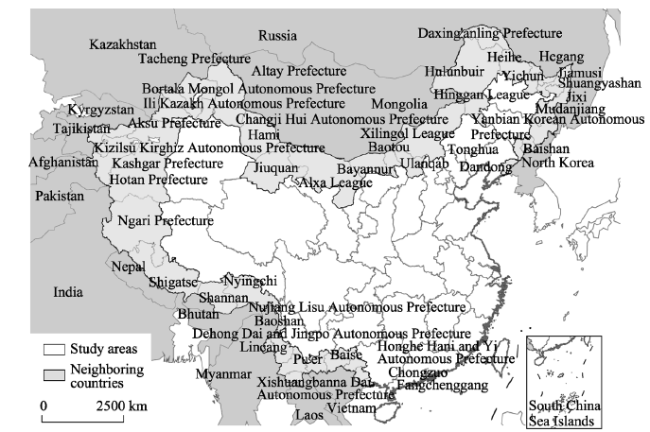
Figure 1 The land border areas of China.
Table 1 The general situation in the border areas of China in 2014
Land
(104 km2)
Percentage of border areas (%) Population
(104 people)
Percentage of border areas (%) GDP
(108 yuan)
Percentage of border areas (%)
Border areas 382 100 7785 100 28,583 100
Nine border provinces 593.19 64.4 28,156 27.6 120,758 23.7
West China 687.97 55.5 36,839 21.1 138,099 20.7
All of China 963.43 39.7 136,782 5.7 643,974 4.4

2.2 Data source

Our research data was obtained mainly from the China Statistical Yearbook for Regional Economy. Data from the statistical yearbooks of the 9 provinces along the borders and prefecture-level cities, as well as the Statistical Communique of National Economy and Social Development published on the municipalities’ websites of prefecture-level cities were used as supplementary material. Data regarding neighboring countries was obtained from the World Bank. Demographic data were mainly obtained from the 5th and 6th national population censuses.

2.3 Theoretic framework of geo-economics

Geo-economics is defined as a set of activities that seek regional economic development and political interest with the help of geographic location in a designated area. Therefore, its measurement index system needs to incorporate multiple factors. The selection of indicators for measuring the geo-economy in border areas should not only satisfy the demand for an export-oriented economy on the national level, but also take into account key elements of regional development for foreign trade, industries and facilities, among others. Currently, most academic measurement methods adopt the Euclidean Distance Method from the multi-factor analysis (Wen, 1998). The selected indicators normally include the percentage of fixed asset investment in the GDP, the percentage of wages of employees in the GDP, the percentage of agricultural output in industrial output, and so forth (Ding and Yu, 2008; Jin and Du, 2004; Liu and Tu, 2011). Indicators used to evaluate the geo-economy include domestic investment, foreign investment, GDP, per capita GDP, industrial structure, labor force structure, technological investment and output, market opportunities, total exports, cultural proximity, national vulnerability, and political risk (Yang et al., 2016; Kuang-Hann, 2011; Buckley et al., 2007). One can observe that research on the geo-economy mainly selects indicators that represent local economic development and that are related to the economic environment such as political stability, spatial distance, and cultural fusion between countries. Based on the theoretical basis of geo-economics and China’s direct foreign investments, and with the help of results from previous studies, this study constructs the measure index system for geo-economic development levels in border areas from the aspects of local economy, export-oriented economy and local comprehensive development (see Table 2). Local economic strength determines the depth and breadth of geo-economic development. This is represented by four indicators: per capita GDP, per capita local revenue, fixed asset investment, and year-end financial account balances. Export-oriented economy is the direct representation of geo-economic positioning. In this study, the total value of imports and exports, the level of dependence on foreign trade, foreign exchange earnings from tourism, and the dependence on foreign investment are selected as indicators to measure the export-oriented economy. These indicators are also used to represent the level of foreign trade activity in border areas and the ability to attract foreign investment. Local comprehensive development reflects the basic conditions for carrying out geo-economic activities. The number of employees, average salary, business volume of postage and telecommunications, and total mileage of highways are used as indicators to measure the local comprehensive developmental conditions, and to reveal differences in the fundamental environment that the geo-economy can develop.
Table 2 The comprehensive measure index system of the geo-economy in the border areas of China
System level Index strata Weight
Local economy (0.311) Gross domestic product (GDP) per capita (yuan) 0.082
Local public revenue per capita (yuan) 0.073
Investments for fixed asset (108 yuan) 0.102
Year-end balance in financial institutions (108 yuan) 0.054
Export-oriented economy
(0.405)
International trade (ten thousand dollars) 0.107
Foreign trade dependence ratio (%) 0.111
International tourism revenue (104 dollars) 0.084
Foreign capital reliance (%) 0.103
Local comprehensive
development (0.284)
Employees (104 people) 0.057
Average wage (yuan) 0.042
Total business volume of post and telecommunications (108 yuan) 0.101
Highway mileage percentage (km/km2) 0.084

2.4 Analytic Hierarchy Process (AHP) entropy method for geo-economic indexes

The entropy method is used in this paper to determine the weight of different indexes. Entropy is a physics concept that is also applied in the social sciences to reflect the measure of uncertainty in a system. The weight of indexes is calculated based on the value of entropy, namely, the variation of multiple indexes (Chen et al., 2009). The entropy method is used to calculate the comprehensive level of geo-economic development. Range standardization is performed on 14 indexes, which include 2816 data items from the years 2000, 2005, 2010 and 2014. Economic indexes are unified and converted to the 2000 level. The formula for this calculation is described below:
\[{{Z}_{ij}}=\frac{{{x}_{ij}}-\min \{{{x}_{ij}}\}}{\max \{{{x}_{ij}}\}-min\{{{x}_{ij}}\}} \ \ (1)\]
The national vulnerability index is a reverse index, and the standardization is performed as follows:
\[{{Z}_{ij}}=\frac{\max \{{{x}_{ij}}\}-{{x}_{ij}}}{\max \{{{x}_{ij}}\}-min\{{{x}_{ij}}\}} \ \ (2)\]
where Xij stands for the value of the jth indicator in region i. They are the minimum and maximum value of the jth indicator in the ith region.
To calculate the weight of the jth indicator in the ith region:
\[{{Y}_{ij}}=\frac{{{Z}_{ij}}}{\sum\limits_{j=1}^{m}{{{Z}_{ij}}}} \ \ (3)\]
Calculation for index of information entropy:
\[{{e}_{j}}=-k\sum\limits_{i=1}^{m}{({{y}_{ij}}\times \ln {{y}_{ij}}),\ \text{ }k=\frac{1}{\ln m}} \ \ (4)\]
Information redundancy:
\[{{d}_{j}}=1-{{e}_{j}} \ \ (5)\]
The weights of the indexes:
\[{{w}_{j}}=\frac{{{d}_{j}}}{\sum\limits_{j=1}^{n}{{{d}_{j}}}} \ \ (6)\]
The comprehensive evaluation index of the geo-economy is calculated. Based on the weights and the standardized value of each index, the calculation of the geo-economic development level of area i is:
\[{{S}_{j}}={{w}_{j}}\times {{Z}_{ij}}\ \ (7)\]
Our study modified the weight of entropy method by consulting experts and combining Analytic Hierarchy Process (AHP). The weights obtained for comprehensive indexes of the geo-economy in the border areas of China are described in Figure 2.

2.5 Geographical detectors

Taking into consideration the developmental level and mechanisms of influence on geo-economics, we generated influencing factors for the comprehensive development level of geo-economics in border areas, shown in Table 3. Since geopolitics are difficult to quantify, this study only measured the State Fragility Index and Cultural Similarity Index. The State Fragility Index, also known as the Political Stability Index, is calculated by the Center for Systemic Peace and is based on military conflict between countries and national sovereignty characteristics. The higher the index value, the more fragile the country, and the less capacity the country has to resist international conflict and violence. The Cultural Similarity Index is represented by the ratio of minority population shared by the region with neighboring countries over the total population of the border areas (Kuang-Hann, 2011). The bilateral economic integration index is a virtual value (Kuang-Hann, 2011): if both countries involved do not participate in any economic agreement, the variable is assigned a value of 1; if both countries have joined the same economic organizations or agreements (i.e., World Trade Organization (WTO), Regional Trade Agreements (RTAs) or Preferential Trade Arrangements (PTAs)), the variable is assigned a value of 2; if both countries are negotiating or if both countries have signed a Free Trade Agreement (FTA), the variable is assigned a value of 4. The development strengths of neighboring countries are calculated from three representative foreign trade economic indexes: imports of goods and services, exports, and GDP. References for calculating the Favorable Policy Index (Li and Fang, 2014). Reference for calculating the Transport Accessibility Index (Liu and Zeng, 2011). Market opportunity is represented by per capita GDP of neighboring countries/per capita GDP of China’s border area.
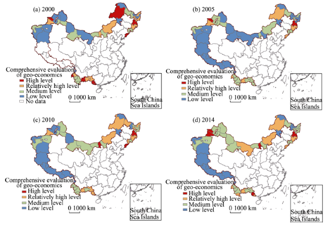
Figure 2 Comprehensive evaluations of geo-economic development in the border areas of China
Table 3 Factors influencing the geo-economy in the border areas of China
Index Explanation of the index Data source Influence of the index
State fragility index Capacity of the country to resist
international conflicts and violence
CSP -
Cultural Similarity
Index
Cultural similarity between the region
and neighboring countries
Fifth and sixth
national censuses
+
Bilateral Economic
Integration Index
The degree of bilateral free trade
between two countries
Value assignment +
Neighboring country
development strength
The comprehensive economic and
foreign trade development levels of neighboring countries
World Bank +
Market opportunities Differences in economic development between the region and neighboring
countries
World Bank +
Favorable Policy Index Level of support from national policies
on regional development
Value assignment +
Number of ports The number of ports in the border area China’s port-of-entry
yearbook
+
Urbanization rate Regional urbanization level China Statistical
Yearbook
+
Secondary and tertiary
industry ratio
Level of off-farm economy in the
region
China Statistical
Yearbook
+
Transport accessibility Level of accessibility of transportation
in the region
Comprehensively
calculated
+
Using geographical detectors developed by Wang Jingfeng and his team, we calculated the explanatory power for comprehensive measurement level of the geo-economy under the geo-economic influencing factors in the border areas of China. After conducting range standardization for indexes, this study discretized data by means of natural breaks. Geographical detectors include four parts: risk detection, factor detection, ecologic detection, and interaction detection (Wang and Hu, 2012). Risk detection is used to explore risk locations, identify the differences between comprehensive evaluation values of the geo-economy under various influencing factors, and also to reveal the factors that significantly influence the highs and lows of the geo-economics. Factor detection is used to identify the factors that can cause the risks. In this study, factor detection is mainly used to measure the explanatory power for geo-economic evaluation values by each influencing factor. Ecologic detection can explain the relative importance of risk factors, compare the explanatory power of different influencing factors, and determine if there are significant differences between these influencing factors. Interaction detection analyzes whether there are influencing factor interactions on geo-economic comprehensive evaluations. Please see related References for methodology (Zhan et al., 2015).

3 Spatial differences of geo-economics in the border areas of China

3.1 Spatio-temporal evolution of geo-economics

We selected 2000, 2005, 2010 and 2014 as the study years (except for the Tibet Autonomous Region, where the year 2000 data were missing) from which to draw data to calculate the geo-economic comprehensive development levels for 45 prefecture-level cities (areas) in the border areas of China. We then used natural breaks in GIS to classify data and divide geo-economic development levels in border areas into four categories: high level, relatively high level, medium level, and low level, as shown in Figure 2.
Considering the temporal evolution of comprehensive measurement levels, both the development levels of the geo-economy in various areas and the values for each subsystem are increasing year after year. The annual growth rate of the overall evaluation value for comprehensive geo-economic development level in border areas is 8.9%; the annual growth rate of the average evaluation value is 8.1%. Under the influence of China’s western development policy, economic trade between border areas and neighboring countries has deepened, regional strategic collaboration has been reached, and the comprehensive geo-economic development level has increased rapidly from 2000 to 2010.
To make the analysis more clear, this study has divided the border areas of China into different regions. We define the border areas in Heilongjinang Province, Jilin Province and Liaoning Province as Northeast China; the border areas of Inner Mongolia (including Jiuquan city in Gansu Province, since they have similar geopolitical environments) as Inner Mongolia area; the border areas of Xinjiang Uygur Autonomous Region and Tibet Autonomous Region by their administrative division as Xinjiang and Tibet respectively; and the border areas in Yunnan Province and Guangxi Zhuang Autonomous Region as Yunnan-Guangxi area.
The comprehensive geo-economic evaluation values of all the areas increased to different degrees. The regions with the highest comprehensive evaluation levels were Mudanjiang city and Fangchenggang city in 2014 and 2000, respectively; the regions with the lowest evaluation levels were Nyingchi Prefecture and Da Hinggan Ling Prefecture in 2014 and 2000, respectively. Compared to all of the border areas, the dominance of Northeast China in geo-economics has decreased gradually. In addition, dominant regions are dispersed significantly in space.
There are significant spatial distribution differences in geo-economic development levels in the border areas of China. By calculating and examining coefficients of variation, we observe that the difference between regions is increasing year after year. Regionally speaking, Mudanjiang had the highest level of geo-economic influence in Northeast China as it has a large market for economic trade with Russia. Currently, three international air routes are in operation between Mudanjiang and Vladivostok, as well as other areas in Russia. As an important border city, Suifenhe is completing its external connection channels to Russia. In addition, Russia boasts abundant mineral resources, low tariffs, a large amount of available labor, and low-priced land. The above factors have all contributed to China’s large-scale investments in Russia. Meanwhile, Northeast China has actively exported agricultural products to and promoted agricultural cooperation with Russia.
As the largest industrial city in Inner Mongolia, Baotou has great strength in this regard. Baotou has also been collaborating with Mongolia in energy, crops, and livestock products; both countries benefit greatly from this partnership. In Xinjiang, the Bortala Mongol Autonomous Prefecture had the highest level of geo-economic influence. Xinjiang has a promising prospect in border trade as it has many open ports along its long border line. As the bridgehead of western China’s opening, Bortala has been playing a critical role in the import and export channels of the 2nd Eurasian Continental Bridge. Alashankou port has the highest ranking among the national land ports in cargo volume handled, customs revenue, and trade revenue. Moreover, bordering countries display an evident will to collaborate. Central Asia is located inland and mostly dependent on a resource-based economy. As such, the import and export channels have become the lifeline of economic development in this region, and collaboration with neighboring countries is essential for economic development.
In the Yunnan-Guangxi area, Dehong Dai and Jingpo Autonomous Prefecture and Chongzuo city are the top two geo-economic influencers. However, the spatial differences are not significant. Although cross border trade was prosperous, there was not a high level of collaboration due to the limited level of economic development in neighboring countries such as Myanmar, Vietnam, and Laos. Due to the improving trade and investment environment in Dehong, infrastructure construction has begun to form in Ruili city, which will lead to the migration of a large number of businessmen, thereby providing a basis for further collaboration in these border areas. As an important channel to connect Southeast Asia with South Asia, Muse has become a prosperous town in northern Myanmar. There is a large potential for cooperation between China and Myanmar, as well as between China and Vietnam. Myanmar and Vietnam also attract many Chinese tourists. Connecting the market of Chinese mainland through southwestern channels is an efficient way to achieve economic prosperity for countries in Southeast Asia. Considering geopolitical strategies, areas that occupy vital communication lines and prosperous border areas usually have prominent advantages for developing their geo-economies. In addition, the dot characteristic of a nation’s policies can further strengthen the spatial differences of the geo-economy.

3.2 Patterns of regional difference of geo-economic development

According to the index weights, the foreign trade dependence ratio (0.111), import and export trade volume (0.107), and foreign capital reliance (0.103) contribute the most to geo-economic development evaluations in the border areas of China. Geo-economics is related to foreign capital utilization and foreign trade credits, and as such is largely influenced by foreign capital. The ability to utilize foreign capital not only reflects the attraction of foreign assets, but also demonstrates the degree of opening-up and the development of export-oriented economy in local areas. Import and export trade volume represents the trade association degree between border areas and neighboring countries. Export-oriented economic subsystems and foreign capital reliance constitute larger weights, which illustrate that using foreign capitals efficiently is an important part of optimizing the geo-economic environment and promoting the development of an export-oriented economy (Figure 3).
Considering the spatio-temporal evolution of geo-economic subsystems in all areas, the comprehensive development of Northeast China and the Yunnan-Guangxi area is relatively better in 2000; however, their foreign economies present evident spatial differences. Areas with better export-oriented economic development are mainly Mudanjiang city, Dandong city, Dehong Dai and Jingpo Autonomous Prefecture and Fangchenggang city. Common characteristics shared by these cities include a developed border economy and smooth cross-border travel. Under coastal-dominant opening-up development, the export-oriented economy grows more slowly in the inland border areas of China, and only a few areas like Bortala and Hulun Buir have relatively better development. In general, most of the inland border areas have slower socio-economic development.
In 2005, the export-oriented economy of border areas underwent a more rapid development. Bortala in Xinjiang and Mudanjiang in Heilongjiang had the fastest development of geo-economic influence. Meanwhile, Bortala Mongol Autonomous Prefecture and Ili Kazakh Autonomous Prefecture in Xinjiang developed quickly and became important areas for growth of export-oriented economy in border areas. With the advantage of having a vital transportation location in Alataw Pass, Bortala has become an important node for opening-up policy and better interaction between China and western countries. Since the second New Eurasion Land Bridge was completed in 1990, and China’s role has increased gradually after joining the World Trade Organization (WTO), the export-oriented economy of Bortala has developed at a fast pace. As a vital city for opening-up in Heilongjiang, Mudanjiang faces the Sea of Japan and has smooth foreign trade channels, producing a fertile environment for the development of the export-oriented economy.
Figure 3 Evaluation of geo-economic subsystems in the border areas of China
In 2010, border areas, especially Northeast China, developed faster; in addition, the local economy and comprehensive development level gradually improved. The cities of Mudanjiang, Heihe, and Dandong have more noteworthy developments in their export-oriented economies. Border areas between China and Russia such as Mudanjiang, Yanbian Korean Autonomous Prefecture, and Heihe have relatively higher overall evaluations. The city of Baotou has the highest development index in Inner Mongolia. However, it does not have substantial geo-economic advantages. The internal differences in geo-economic standing in Xinjiang are decreasing. The import and export trade volume of Bortala is suffering a significant decrease. Although the Ili has better geo-economic conditions, it is still not comparable to coastal cities such as Mudanjiang and Chongzuo. The local comprehensive environment is relatively good in the Yunnan-Guangxi area, which is reflected on the geo-economic development of Fangchenggang city and Dehong prefecture. However, the regions with better geo-economic development are still located in the cities of Chongzuo and Baise, which are along the coastal lines. Other cities take fewer advantages of local resources.
The local economy in most regions had rapid growth in 2014. Based on the spatial different pattern in 2010, the export-oriented economy of Bortala and Ili prefectures was developing quickly; these cities became growth poles in 2010.
In general, the internal geo-economic differences in Northeast and Southwest China are relatively small. Border areas between China and Russia, as well as Dandong in Northeast China, are developing strong geo-economic stances. Although China and North Korea share similar cultures, North Korea refuses to implement an open policy. Two-way trade is confined to government procurement with limited trade volume. Thus, the development of geo-economic advantages is restricted. The Yunnan-Guangxi area should take full advantage of its local comprehensive environment and promote its export-oriented economy to accelerate the development of the local economy. The Xinjiang area focuses on the development of areas with greater potential. The Chinese government invests more in the Bortala prefecture, which has allowed it to attain dominance in Inner Mongolia. The differences within Inner Mongolia are mainly reflected by its economic development environments. Baotou city has the best economic strength. Due to relatively low levels of socio-economic and geo-economic development in Mongolia, using Mongolia to connect Russia, Central Asia, and Europe is critical for the export-oriented economy in Inner Mongolia. Constrained by unfavorable topographical conditions, the Tibet area has a small volume of foreign trade, and its indexes are not significant in influencing geo-economics.

4 Analysis of differentiation of geo-economy in the border areas of China

4.1 Analysis of the geo-economic differentiation

To reveal the influence mechanisms for geo-economics in border areas of China, this study used the geographic detection method to analyze the differentiation in geo-economics, which includes risk detection, factor detection, ecologic detection, and interactive detection.
The results of risk detection indicated that with the significance level set at 0.05, the factors determining the differentiation of geo-economic development include favorable policy index, transport accessibility, cultural proximity, and bilateral economic integration, which all have a positive influence on geo-economics. Policies favorable for export-oriented economy and strengthened economic interactions with neighboring countries give a strong boost to economic growth in border areas.
The results of factor detection indicate that the favorable policy index has the greatest explanatory power as well as a significant influence on geo-economics. The Favorable Policy Index also serves as a key factor in the promotion of geo-economic development in border areas. The Chinese government has extended favorable policies and increased investment in border areas, which include improving infrastructure such as transportation and building cross-border economic zones. For instance, Horgos Port is improving quickly in its geo-economic standing, economic environment, and urbanization because it is the only city that enjoys the favorable policy of hosting a special economic zone in Horgos along the border area of China-Kazakhstan. Due to the improvement in geo-economic standing and economic environment, urbanization in ports is accelerating, and the area of development zones is expanding. With the support of special policies, the Horgos Port is no longer under the governance of Huocheng county and Yili city, but instead under that of Horgos city. This may become the economic zone with the greatest potential in western China.
Bilateral economic integration and the number of ports also have a certain explanatory power (Table 4). In earlier history, China’s border opening-up policies were implemented in ports and border cities. As bilateral economic relations have been thriving since the beginning of development in western China, port areas represented by Alataw Pass, Manchuria, and Pingxiang have a great opportunity to further develop. Bilateral free trade with neighboring countries and further opening up has strengthened geo-economic positioning. Meanwhile, similar languages and cultures promoted the cultural exchange environment and bilateral trade. Due to the financial crisis in 2008, the explanatory power of indexes changed in 2010; the transport accessibility and State Fragility Index had relatively high explanatory powers. Border areas that serve as critical connections between China and bordering countries have geo-economic advantages. Areas with limited capacity to resist financial crisis and regions in the China-Myanmar border area have experienced a slower or even negative growth in economic development. Furthermore, the explanatory power of indicators for border areas is experiencing a transition from a single element to multiple factors, and the difference between indicators is decreasing.
Table 4 The explanatory power of influencing factors of the geo-economy in the border areas of China
State fragility index Cultural proximity Bilateral economic integration level Development strength of neighboring countries Market opportunities Preferential policy index Number of ports of entry Urbani-
zation rate
2000 0.098 0.214 0.485 0.078 0.045 0.578 0.252 0.141
2005 0.046 0.261 0.526 0.080 0.068 0.523 0.145 0.235
2010 0.307 0.194 0.229 0.281 0.147 0.427 0.234 0.273
2014 0.112 0.282 0.264 0.094 0.294 0.650 0.213 0.196
Ecological exploration focuses on comparing the impacts of different influencing factors on the explanatory power of geo-economics and determining the relative importance of these factors. Results show that the explanatory power of favorable policy index is significantly larger than other influencing factors, while the difference of explanatory power between other factors is not statistically significant.
Interactive detection analyzes the impact of different factors on the comprehensive evaluation value of geo-economics and determines whether there is any interaction. In the years studied, there are combinations whose explanatory power appears to be more significant and shows non-linear reinforcement after the interaction of different influencing factors. In 2000, 2005, and 2014, most factors are non-linearly strengthened in explanatory power after interactions. In 2010, most factors showed bi-linear strengthening after interactions, indicating that the comprehensive geo-economic level of border areas in 2010 was mainly the result of interactions between the majority of the influencing factors. This is substantiated by the insignificant difference in the explanatory powers of different factors in 2010. After combining the favorable policy index and other factors such as bilateral economic integration level, cultural proximity, traffic flow, and accessibility, the explanatory power is significantly greater than the sum of the explanatory powers of any two factors. In the border areas with sufficient regional development potential and similar culture shared with neighboring countries, conducting bilateral trade negotiations with neighboring countries and implementing regional favorable policies will effectively promote geo-economic development.

4.2 Analysis of mechanisms of geo-economy in different border areas

In this study, the regional differentiation characteristics of geo-economics are analyzed using the geographic detection method that includes risk detection, factor detection, ecologic detection, and interactive detection. Another focus of this study is the influencing mechanism of regional geo-economy in border areas (Table 5).
Risk detection: At a significance level of 0.05, market opportunities, the ratio of secondary to tertiary industry, and transport accessibility have a significant impact in Northeast China. In Inner Mongolia and Tibet, the economic development of neighboring countries plays a critical role in the geo-economic evaluation, while in Xinjiang and Yunnan-Guangxi area the ratio of secondary to tertiary industry is the most important factor. The classification values of other influencing factors did not show significant impacts on the comprehensive evaluation. In Xinjiang, as well as the Yunnan-Guangxi area, the ratio of secondary to tertiary industry is low, which has a more significant impact on the evaluation of geo-economics.
Factor detection: The difference in the explanatory power of regional influencing factors is significant. The geo-economy in Inner Mongolia is greatly affected by neighboring countries, especially with regard to their development. Meanwhile, national vulnerability and cultural proximity also have a strong impact. There is a wide border area between Inner Mongolia and Mongolia. Mongolia is a lower-middle income country, which is located deeply inland, and has a relatively small trade volume of imports and exports. These factors all limit the development of geo-economics in Inner Mongolia. The explanatory power of favorable policy indexes is most significant in Northeast China and Xinjiang. In the context of the “Planning for Revitalization in Northeast China” policy, the number of border economic cooperation zones in this region has increased. Xinjiang has favorable policies that play a crucial role in promoting the development of geo-economics. In Tibet, the development of neighboring countries and bilateral economic integration levels have the greatest explanatory power; these two factors are most important. Measurement results show that the geo-economic environment of the Tibet area is mainly influenced by its neighboring countries. Considering the situation in Tibet, border areas have complex topography and fewer populations; thus there is significant resistance to an export-oriented economy. In addition, neighboring countries such as Pakistan, India and Bhutan have lower levels of economic development and foreign trade. Free trade negotiations between these countries and China are progressing slowly. Both natural conditions and the economic environment have restricted geo-economic development in Tibet. However, under the influence of various factors, there is no large difference in explanatory power in the different indexes in the Yunnan-Guangxi area. The development level of neighboring countries, the cooperative willingness of neighboring countries, and the presence of favorable policies in border areas all play important roles in the development of geo-economics.
Table 5 The explanatory power of the influencing factors in geo-economy in the border areas of China
State Fragility Index Cultural proximity Bilateral economic integration level Development of neighboring countries Market opportunities Favorable Policy Index Number of ports of entry Urbanization rate Ratio of secondary to tertiary industry Transportation accessibility
Inner Mongolia 0.484 0.420 0.346 0.489 0.326 0.073 0.163 0.378 0.360 0.132
Northeast China 0.201 0.255 0.398 0.301 0.181 0.640 0.302 0.304 0.249 0.393
Xinjiang 0.106 0.185 0.278 0.305 0.119 0.502 0.290 0.222 0.140 0.226
Tibet 0.085 0.100 0.756 0.934 0.314 0.083 0.112 0.097 0.111 0.111
Yunnan- Guangxi area 0.477 0.176 0.402 0.434 0.126 0.441 0.267 0.230 0.330 0.234
Considering the regional differences in explanatory power of influencing factors, the geo- economics of border areas are mainly affected by two elements: favorable Chinese policies for border areas, and the development level of neighboring countries, including their willingness to conduct bilateral trade with China. The Inner Mongolia and Tibet areas are mainly influenced by neighboring countries, while Northeast China and Xinjiang are mainly affected by Chinese policies; the Yunnan-Guangxi area is influenced by a combination of these factors.
Ecologic detection: The explanatory power of different influencing factors is not significantly different in Inner Mongolia and Xinjiang. The state fragility index in the Yunnan-Guangxi area has a significant impact since this area neighbors Myanmar, Laos and Vietnam, and is strongly affected by these countries’ unstable geopolitical environments. The favorable policy index in Northeast China and the development of neighboring countries in Tibet have significantly higher explanatory powers than other indexes. The Favorable Policy Index is more significant, which indicates that human factors cannot easily change the geo-economic development under different country power levels.
Interactive detection: The explanatory power of a combination of different factors is significantly greater than that of any single factor in all areas. Inner Mongolia, Northeast China, Tibet, and the Yunnan-Guangxi area depict a bilinear increase in explanatory power, while Xinjiang exhibits a non-linear increase. Thus, the geo-economies of border areas are mainly affected by integrating factors, especially the nation’s internal and external factors.

5 Conclusions and discussion

Under economic globalization, different regions are interacting more closely, and geo- political risks are becoming increasingly complex. The border areas are the core catalyst for interactions between China and its neighboring countries, and also important regions with high population density and industry as well as large economies. This study attempts to describe the spatio-temporal differentiation of the geo-economy in the border areas of China under globalization, and analyzes the mechanism of differentiation in the geo-economy using geographic detectors. The entropy method is used to conduct a comprehensive evaluation of the geo-economy, which demonstrates that export-oriented economies have become the main geo-economic characteristics of Chinese border areas. From 2000 to 2014, geo-economics has driven the overall development and opening up in the border areas of China. The absolute dominance of Northeast China in geo-economics has gradually weakened over time, and the importance of Xinjiang has become more evident. The border areas which developed and opened up first, such as the international cooperation demonstration areas and the key development and opening-up pilot zones, promoted the formation of growth poles in the border areas and formed the differentiated spatial structure. Analysis of the mechanism of geo-economics through the use of geographic detectors shows that export- oriented policy, bilateral economic integration level, and market opportunities play a crucial role in influencing geo-economics in the Chinese border areas. Under complex geographic conditions, export-oriented policy has a significant effect on the polarization of border areas.
The developmental strategy of spatial differentiation in border areas has further strengthened the spatial difference in geo-economics. In the context of the “Belt and Road Initiative”, the development and opening up of western China has become an evident trend. Northwest China, primarily Xinjiang, is progressively exhibiting its strategic dominance. The geo-economics of this region is rapidly growing, and is gradually becoming the new economic growth pole in the border areas of China. The study of the mechanism of differentiation in geo-economics shows that geo-economics is heavily influenced by geopolitics. The development of neighboring countries, national vulnerability, and other factors further influence economic development and foreign trade in border areas. Meanwhile, under the guidance of certain policies, geo-economic development is useful in reducing border conflicts and improving border security. Guided by border opening-up policies, the economy grows rapidly in the northwest and southwest border areas of China. These results indicate that the special policy areas, such as the border cooperation areas and the key development and opening-up zones, have a significant impact on the geo-economic growth of border areas. Accordingly, the application of such policies in more places should be encouraged in the future. Therefore, strengthening the geo-economic position of border areas which have favorable locations, good foundations, and a stable surrounding environment is helpful for building a safe and stable geo-economic space, improving the bilateral economic trade level, and maintaining the economic and political environment in neighboring countries as well as in China. In addition, this would assist in building a solid foundation to support the maintenance of overall security and stability in China.
Compared to the traditional research on borders that is mainly based on the economy and society of border areas, geo-economics, as the latest trend in the study of geopolitics, contains an inductive method to investigate the spatial characteristics of economic factors at multiple scales. First, geo-economics focuses on studying the problems and phenomena of an export-oriented economy under globalization. It is no longer limited to the factor explanation and spatial structure of regional development and the current status. Further research needs to place the region into a larger scale in order to carry out systematic analyses. The geo-economic theory needs to take into account both the domestic and international benefit structures with the characteristics of hierarchy and complexity. Based on the study of border areas, the geopolitical condition of neighboring countries, policy stability, and international trade environment all affect the development of border areas. The author believes that this approach helps to break the constraints of western theory, to gain a deeper understanding of the key elements of geo-economic society in different regions and the spatial relations between these elements, and also helps to reveal the uniqueness of Chinese border areas. It is highly important for academics and the Chinese government to explore the development level, process of evolution, and driving force behind geo-economics. It serves China’s “Belt and Road Initiative” and “Comprehensive Border Opening-up” strategy. It is also valuable in the promotion of regional development, and provides the theoretical basis and geographic support for carrying out geo-economic cooperation with neighboring countries. This is an early-stage study that lacks consideration in the design of technical methods and the selection of geo-economic indexes. For example, the entropy weighting method determines the weight based on the degree of discretization of data. This is objective, but the weight may be inconsistent with regard to the importance of the index. In addition, geographic detectors can only calculate discrete data, which lowers the internal difference in sampled data. Moreover, interactive detection can obtain the results of the interaction between any two factors; however, it cannot analyze the interactions between multiple factors. These issues need to be resolved through the use of new perspectives and methods.

The authors have declared that no competing interests exist.

[1]
Brunet-Jailly E, 2005. Theorizing borders: An interdisciplinary perspective.Geopolitics, 10(4): 633-649.The current renewed interest in the study of borders and borderlands is paralleled by a growing concern and debate on the possibility of a border model, or models, and of a border theory, or theories. Certainly, there is a new attention to theoretical consideration and discussion that could help sharpen our understanding of borders. In this essay, I argue that a model or general framework is helpful for understanding borders, and I suggest a theory of borders. The seeds of my arguments are grounded in a variety of discussions and in the works of border scholars from a variety of social science disciplines. My contention is that the literature on borders, boundaries, frontiers, and borderland regions suggests four equally important analytical lenses: (1) market forces and trade flows, (2) policy activities of multiple levels of governments on adjacent borders, (3) the particular political clout of borderland communities, and (4) the specific culture of borderland communities. A model of border studies is presented in the second part of this essay, and I argue that these lenses provide a way of developing a model that delineates a constellation of variables along four dimensions.

DOI

[2]
Buckley P J, Clegg L J, Cross Aet al., 2007. The determinants of Chinese outward foreign direct investment.Journal of International Business Studies, 38: 499-518.

DOI

[3]
Chen Mingxing, Lu Dadao, Zhang Hua, 2009. Comprehensive evaluation and the driving factors of China’s urbanization.Acta Geographica Sinica, 64(4): 387-398. (in Chinese)From the essential meaning of urbanization,this paper establishes a comprehensive evaluation index system,including four aspects changing:population,economy,society and land.Based on the method of entropy,the measure and evolution of China's urbanization are analyzed since 1981.The results show that China's comprehensive urbanization level continues improving.Economic growth and geographical landscape are the main features of rapid evolution of urbanization,followed by the population urbanization,and the medical care level of social urbanization is the least advanced.The evolution of all the four subsystems has unique characteristics.The analysis of multiple regression model shows that the driving factors have been diversified.The market force is the most powerful driving force of China's urbanization,followed by intrinsic force,administration force,exterior force.From different stages of urbanization,the effects of market force,exterior force and the administration force on urbanization are increasing,while intrinsic force is decreasing.China's urbanization is the main endogenous process,hence more policies should be formulated to strengthen the market economy reform and coordinate urban and rural development.

[4]
Chou Kuang-Hann, Chen Chien-Hsun, Mai Chao-Cheng, 2011. The impact of third-country effects and economic integration on China’s outward FDI.Economic Modelling, 28: 2154-2163.78 China's OFDI is a complex FDI without third-country effects. 78 The economic integration and political risk both have a negative effect. 78 The host country's market opportunity has a negative effect. 78 Asia's cultural proximity is also in harmony with China's OFDI preferences.

DOI

[5]
Cui Jun, 2004. A research on geo-economic cooperation in Northeast Asia [D]. Changchun: Jilin University. (in Chinese)

[6]
Ding Hongjian, Yu Zhenguo, 2008. An analysis of the match between the direction and intensity of urban economic contact and the geoeconomic relationship.China Soft Science, (3): 44-51. (in Chinese)This paper,taking Tangshan as an example,calculates the strength of regional economic contact and geo-economic relationship between Tangshan and 42 cities in five province of the Bohai rim based on the gravity model and Euclidean distance formula.And the paper analyses the primary directions of regional economic contact,and matches the economic contact and geo-economic relationship.The primary directions are identified by the strength of regional economic contact.Through the measurement and comparision of regional economic contact,giving the main direction for regional economic development,is in favor of coordinating the contact and cooperation within zones.

[7]
Feng Guoqun, Ding Sibao, 2005. Retrospect and prospect of the cross-border cooperation study.World Regional Studies, 14(1): 53-59. (in Chinese)This paper introduces firstly basic conceptions and theories on the boundary and cross - bonier cooperation ( CBC) , especially the different functions of the boundary. The study of border region and CBC is then reviewed in respect of the political geography and the economic geography, and an outline of historical development of the boundary study has been described. The questions posed are how political and economic borders exert an influence on boundary landscape and the CBC. This was followed by analysis and generalization of some CBCs in the developed EL and developing countries respectively. In the end, some characteristics and prospects about the CBC between China and its neighbors are discussed and based on this free trade areas, port cities and transit functions are highlighted.

[8]
Gao Jiaxiang, 2008. Geo-economy and China’s geo-strategy in Central Asia [D]. Lanzhou: Northwest Normal University. (in Chinese)

[9]
Gao Shuqin, 2009. The factor ‘Natural Resources’ in the transformation of global geopolitics and geo-economy.Resources Sciences, 31(2): 343-351. (in Chinese)This article focuses on analyzing the role of natural resources in the historical transformation of global geopolitics and geo-economy systems,the relations of natural resources and global geopolitics and geo-economy and industrial civilization,and the relation between natural resources and state foreign strategic policy.First of all,the author defines the terms'natural resources'and'global geopolitics and geo-economy'and then analyzes how the theory of continental geography control and sea control power came into being and developed.Next,the author,based on the development of the technologic revolution and transformation of international systems,points out the distinctive features of supply development of natural resources systems.Before the end of the cold war,there were very clear boundaries inside global natural resources supply system.After the cold war,the third technologic revolution changed this situation and has driven natural resources into a progress of globalization due to the demand of global economy.This global issue has great influences on the geopolitical environment.This paper is trying to draw special attention to the geopolitical environment and China's foreign strategy and discusses how China formed strategy of energy supply and surrounding security environments.Secondly,the author demonstrates the historical transformation of global geopolitics and geo-economy and influences of natural resources.From the point of international politics and economy,natural resources have brought many challenges to the state's foreign strategy,including inner changes of political economic policy.Therefore,countries exporting natural resources have a special model of economic and political development:economic issues have obvious political character,especially the management of natural resources and strategic problems.The exploitation of natural resources is related to the development of social economic situation and conflicts between nations.Furthermore,by analyzing the influence of natural resources on global geopolitics and geo-economics,the author indicates not only a logical relationship of natural resources and their geographic distribution and industry development,but also draws attention to the influences of natural resources on the division of world economy and development of international law.The Declaration of Permanent Sovereignty over Natural Resources is the basis for the legal development of natural resources.The United Nations Convention on the Law of the Sea is the basis for resolution of the disputes over sea natural resources.

[10]
Hanson G H, 1998. Regional adjustment to trade liberalization.Regional Science and Urban Economics, 28: 419-444.In this paper, I examine the effect of trade reform on regional employment in Mexico. Three factors condition regional labor demand: (1) transport costs, which encourage firms to locate in regions with good access to foreign markets; (2) backward–forward linkages, which encourage firms to locate near buyers and suppliers, and (3) agglomeration economies, which reinforce the pre-trade pattern of industry location. The results suggest transport costs and backward–forward linkages influence regional employment. Post-trade employment growth is relatively high in regional industries that are close to the United States and near upstream and downstream industries. Trade reform appears to have contributed to the breakup of the Mexico City manufacturing belt and the formation of new industry centers in northern Mexico.

DOI

[11]
Hu Zhiding, Ge Yuejing, Bao Jieet al., 2013. The spatial pattern and differentiation laws of geo-setting in South Asia.Scientia Geographica Sinica, 33(6): 685-692. (in Chinese)The geopolitical setting study is the second attempt to revive the political geography of the geographical circles,also it reflects the political geography studied from a single element to multiple elements and integrated development.Based on the two"geopolitical setting"international seminar which held in Beijing and the early geographical environment research,the geo-setting is defined which contains geographical environment,geographical relations and geographical structure in this article.Geographical environment is consist of the natural environment,economic and population environment,and the social and cultural environment.Geopolitical relations includes economic relations,political and military relations,and social and cultural environment.The geographical structure contains political military structure,economic structure and space structure.And then,the article uses a combination of AHP decision-making analysis and fuzzy comprehensive evaluation method to evaluate the geo-setting of South Asia quantitatively.The results show that: In South Asia there exists significant space divided differences in the geographical environment,geopolitical relations and geo-structures,which eventually led to the geo-setting in South Asia can be divided into four categories,India for a class,Pakistan and Bangladesh for a class,Bhutan and Nepal for a class,Sri Lanka and Maldives as a class.There are three reasons which caused this spatial differentiation,which are geographic determinism,interdependence theory and institutional theory.

[12]
Huang Hui, 2011. A research on geo-economic cooperation of China and its neighbors [D]. Changchun: Northeast Normal University. (in Chinese)

[13]
Jin Fenghua, Du Jizhong, 2004. Measurement and analysis on the economic relations of the similar regional origin in Yangtze Delta. East China Economic Management, 18(1): 4-6. (in Chinese)The economic relations of the similar regional origin in Yangtze Delta has a great impact on the harmonious development of regional economy.This article designs a measurement system for the economic relations of the similar regional origin,then measures the economic relations between 15 areas in Yangtze Delta,and finally proposes relative policy sugessions.

[14]
Li Guangdong, Fang Chuanglin, 2014. Quantitative measure and influencing mechanism of land intensive use in China at the county level.Acta Geographica Sinica, 69(12): 1739-1752. (in Chinese)Land use issue is an important constraining force for economic sustainable development of China. Urban and rural rapid expansion depletes valued land resources under the background of rapid urbanization. An extensive use pattern might cause a serious waste of land resources. The study on influencing mechanism of land intensive use (LIU) in China at the county level is an important tool for effective LIU practice and policy-making. This paper uses OLS model, Spatial Panel Lagged model and Spatial Panel Error model to characterize the influencing mechanisms of five class factors and 17 variables supported by GIS (Geographic Information System) and MATLAB. And a comprehensive data set, including physical geography attributes and socio-economic information with 2286 counties, was developed. Meanwhile, the spatiotemporal pattern of LIU has been discussed by means of GIS. The results show that Spatial Panel Data models are slightly superior to OLS model in terms of significance and confidence level. Regression results of these models indicate that industrialization, urbanization, economic development level, location, transportation and policy have significant impact on LIU of counties. The variables of physical geography are less significant than socio-economic variables. An ignored variable of historical factor, however, became the most significant factor. In the future, the LIU at the county level should enhance favorable factors and reduce disadvantageous ones, which can be acquired by improving the entire level and quality of industrialization and urbanization. We argued that an efficient and complete land market and operating system should be built to reflect marketoriented activities at the first place. Then, according to regional differences, differential LIU regulation policies and measurements should be optimized. Meanwhile, we should pay close attention to the carrying capacity of local resources and environments when conducting LIU practices.

DOI

[15]
Li Hong, 2008. Border Economy: The Entry Point of the Regional Cooperation between China and ASEAN. Beijing: Zhonghua Book Company. (in Chinese)

[16]
Li Peng, 2006. On the cooperation development of geoeconomic regions and its practice tactics adjustment: Taking the analysis of cooperation development of geoeconomic regions between China and ASEAN as an example.Economic Geography, 26(2): 186-191. (in Chinese)

[17]
Li Zheng, Chen Cai, Xiong Liran, 2014. An analysis on the theory origin and development vein of geo-economics abroad.World Regional Studies, 23(1): 10-18. (in Chinese)Geo-economics was advanced by researchers of Europe and America in1990s,and then it was speeded over the academics. But there were some different views towards its concept and nature,which has affected the development of the theory. This paper discriminate the nature and connotation of features from the practice of Europe and America of geo-economics background,theoretical origin,the development of schools and so on by a view of embryology. The main research conclusions are as follows:(1) Geo-economics of Europe and America has profound theoretic origin. The re-occurrence of geo-economical cooperation around the world is one vital resource and theoretical background of the birth of Geo-economics. Meanwhile,the expansion of several other similar or related economic theories brings about its birth academically and geo-politics is its direct academic resource.(2)As space spread of the geo-economic theory,there are a multicentre centers of distinctive theory school such as the USA,Italy and Russia. The interaction among theories,views,and academic schools of different sub-subjects has made Geo-economics rather sophisticated;(3) Al though geo-economics has formed its own unique theoretical characteristics different from geo-politics,it is still at the very early stage of its development with obscure research border,yet-to-be-build theoretical foundation and imperfect theoretical system.

[18]
Liu Chuanming, Zeng Juxin, 2011. The calculating method about the comprehensive transport accessibility and its correlation with economic development at country level: The statistical analysis of 79 counties in Hubei Province. Geographical Research, 30(12): 2209-2221. (in Chinese)There is close relationship between the comprehensive transport accessibility(CTA) and the level of economic development(LED) at county level.The article uses some statistical analysis methods to analyze their relationship.Firstly,it modifies the valuation method to calculate the CTA which is not influenced by the analysis spatial scale based on the current research results.Especially,the railway station is regarded as an important transport node and its level has very important influence on the accessibility in the new method.Secondly,it evaluates the CTA of 79 counties in Hubei Province with this method.And it analyzes the spatial difference of the CTA in this province based on the result of systems cluster analysis.Thirdly,it evaluates the level of county economic development and its spatial difference with the method of principal component analysis and system cluster analysis.Fourthly,the non-liner statistical correlation between the CTA with the LED at county level is revealed by the method of correlation analysis and curve fit analysis.Fifthly,this paper analyzes the combination type of CTA and LED with the 33 matrix,and the spatial distribution rule of different types of counties as well.Finally,it is suggested that we should choose the imbalanced spatial development strategy,such as pole-axis development.And this article builds a spatial development mode which is "one main center city,two associate center cities,three city-and-town concentrated areas and four economic zones".In addition,it put forwards some suggestions for upgrading the county CTA in Hubei Province.

DOI

[19]
Liu Yuanyuan, Tu Jianjun, 2011. Study on the geo-economic relations of Central Plains Economic Zone.Areal Research and Development, 30(6): 156-159. (in Chinese)At the present stage,the national strategic focus on promoting the Central Plains Economic Zone has provided broad development opportunities and prospects for Central Plains Economic Zone.As the core of Central Plains Economic Zone,Zhengzhou is becoming growth pole with its great economic radiation and driving force,holds an important position.By a measurement system for Central Plains Economic Zone's geo-economic relation,utilizing Euclidean distance device,the paper has analyzed the economic relations between Zhengzhou and 28 areas in the Central Plains Economic Zone.Cities of the Central Plains Economic Zone are divided into four categories: the strong competitive city,the general competitive city,the general complementary city,the strong complementary city.This study has pointed out the strengths and weaknesses of Zhengzhou's geo-economic relations.The results show that the Central Plains Economic Zone's geo-economic relationship is severe.From the whole,competition is greater than complementary.Therefore,cities should adopt different strategies based on different geo-economic relations type.

[20]
Lu Dadao, Du Debin, 2013. Some thoughts on the strengthening of geopolitical and geo-economic studies.Acta Geographica Sinica, 68(6): 723-727. (in Chinese)The rise and fall of the great powers undoubtedly is not dominated by geo-political and geo-economic rules. Since the end of the Cold War, with the rapid economic development of China and other emerging countries, the international power structure is undergoing profound restructuring and the world is entering the new geo-political and geo-economic era. At present, China's geopolitical environment has become increasingly complex and its peaceful development urgently needs geopolitical and geo-economic theoretical support. Based on analysis of the current world geopolitical and geo-economic development trend, this paper discusses the ideological origins on the fundamental role of geography in the development of geopolitics and geo-economics; analyzes the deficiencies of the Chinese geographers in the field of geopolitics and geo-economics; and then puts forward some suggestions how to strengthen the geopolitical geo-economic studies.

[21]
Luo Huasong, Li Feng, 2010. An analysis of the optimal cooperation model of Yunnan multilateral industrial cooperation.Journal of Yunnan Normal University (Philosophy and Social Sciences Edition), 42(2): 65-71. (in Chinese)By determining and estimating the value of relevant parameters of collaborative product collection,input-output tables,upper and lower limits of export and import products,the maximum output capacity of various sectors in Yunnan Province as well as relevant prices,this paper with its basic assumptions brings up the optimal cooperation model of Yunnan multilateral industrial cooperation made of the objective function and related constraints.The paper testifies this model through demonstrating and authenticating it from two perspectives:one is the influence of the change of a single resource input scale on the product output scale and added value;the other is the influence of the potential growth of the first industry,construction,the third industry and other industries on such cooperation.

[22]
Luttwak E N, 1990. From geopolitics to geoeconomics: Logic of conflict, grammar of commerce.The National Interest, 20(3): 17-23.react-text: 433 The article begins with the explanation of the lex orandi - lex credendi principle, which is the basis of reflection. If we accept this axiom as valid, the most proper way to discourse on Eucharist theology is the analysis of Eucharistic prayers of the East and West. We then outline the literary structure of this type of church prayer, identifying it as a prayer of alliance (tod) as found in... /react-text react-text: 434 /react-text [Show full abstract]

[23]
Newman D, Paasi A, 1998. Fences and neighbors in the postmodern world: Boundary narratives in political geography.Progress in Human Geography, 22(2): 186-207.State boundaries have constituted a major topic in the tradition of political geography. Boundary analysis has focused on the international scale, since international boundaries provide perhaps the most explicit manifestation of the large-scale connection between politics and geography. The past decade has witnessed a renewed interest in boundaries, both within geography and from the wider field of social theory. Geographers have sought to place the notions of boundary within other social theoretical constructs, while other social scientists have attempted to understand the role of space and, in some cases, territory in their understanding of personal, group, and national boundaries and identities. Recent studies include analyses of the postmodern ideas of territoriality and the `disappearance' of borders, the construction of sociospatial identities, socialization narratives in which boundaries are responsible for creating the `us' and the `Other', and the different scale dimensions of boundary research. These can be brought together within a multidimensional, multidisciplinary framework for the future study of boundary phenomena.

DOI

[24]
Nye J, 2004. Soft Power: The Means to Success in World Politics. Public Affairs.

[25]
Pan Zhongqi, Huang Renwei, 2008. Geo-economic strategies of China.Journal of Tsinghua University (Philosophy and Social Sciences), 23(5): 116-122. (in Chinese)

[26]
Parker G, 1998. Geopolitics: Past, Present and Future. London: Pinter.

[27]
Ratti R, Reichman S, 1993. Theory and Practice of Transborder Cooperation. Verlag Helbing & Lichtenhahn, Basel und Frankfurt am Main.

[28]
Sit V F S, 1998. Hong Kong’s “transferred” industrialization and industrial geography.Asian Survey, 38(9): 880-904.

DOI

[29]
Sklair L, 1993. Assembling for Development: The Maquila Industry in Mexico and the US. San Diago: Center for US-Mexico Studies.

[30]
Song Tao, Liu Weidong, Li Le, 2016. International research on the border regions with a geopolitical perspective and revelation.Progress in Geography, 35(3): 276-285. (in Chinese)边境地区是国家重要的国土安全屏障和对外开放门户。在全球化、信息化的背景下,边境地区成为地理学、政治学和政治经济学的研究热点。科学认识和总结国际边境研究是推进学科发展的前提。本文以科学引文索引(Web of Science)中边境研究的学术论文为依据,借助于Citespace科学计量工具,系统回顾了国外1990-2015年边境研究的发展脉络、研究领域重点和研究趋势。从文献计量统计分析来看,1990年以来刊文量最大的期刊包括《政治地理学》(Political Geography)、《地缘政治学》(Geopolitics)等。国外边境研究的领域集中于政治地理、环境生态、商业经济、公共管治、人文艺术等方面。地缘政治视角下的领土、国家权力始终是边境研究的重要内容。新世纪以来,边境研究在汲取了批判性地缘政治学、人本主义地缘政治的精髓后,逐渐增强了对边境环境、社会治理等方面的反思。在文献计量分析的基础上,重点阐述了边境的地理涵义和政治属性、经济商贸交流、边境一体化、边境冲突与安全、文化与社会建构、跨境合作制度等领域的研究趋势。最后提出,未来中国边境研究应增强边境地区的综合性发展战略研究,搭建适应于中国特色发展的跨境合作平台与机制,融入国际政治学、民族学、自然地理学等多学科视角。

DOI

[31]
Song Tao, Lu Dadao, Liang Yiet al., 2016. Research progress of international geopolitics, 1996-2015.Acta Geographica Sinica, 71(4): 551-563. (in Chinese)Geopolitics, which conducts research on the international relations in view of geographies, exerts powerful influences on the course of economic and political development in the world. In the tide of globalization and information technology, the geopolitics has become an important subject of global pattern interpretation and policy making. It is important to have a scientific and systematic review on latest development of international geopolitics for promoting the development of this discipline. Based on the bibliometric statistics, the paper reviews the research development of geopolitics based on data from the Web of Science during1996- 2015. The history, journals, papers and key research areas of geopolitics are revealed in this paper. By the analysis of bibliometric statistics, we found that the number of papers recently published in the journals of political geography and related geography continues to increase. The key areas of geopolitical papers which are global highly cited include geopolitical interpretation of the countries and the borders, critical geopolitics, emotional geopolitics,feminism geopolitics and other topics. Before 2000, the states and the borders are hot topics of the geopolitical research. Since 2000, it is of great significance that the geopolitics should be placed in the context of geographical implications. At the same time, critical geopolitics tends to be the main area of geopolitical research, especially the shifts from traditional geopolitics to the humanism(such as emotional geopolitics, feminism geopolitics). The paper then systematically reviews the branch trends of geopolitical research, including the borders and the territory, global geo- culture and geo- economics, Chinese models of geopolitics, resource conflicts and ecological politics, emotional geopolitics. Finally, it puts forward that Chinese geopolitical studies should reinforce the importance of geographical space and scale, use the process of description and multiple methods, as well as integrate humanistic thoughts, to further enrich the theories and practices of geopolitical research.

DOI

[32]
Su X B, 2012. Rescaling the Chinese state and regionalization in the Great Mekong Subregion.Review of International Political Economy, 19(3): 501-527.In the past five years, the Chinese state has made great effort to implement its 'going-out' strategy, i.e., the geographical expansion of Chinese capital and labor overseas. This paper explores how the Chinese state rescales to implement this going-out strategy and produce new spaces of development. Particularly, this paper examines how the Chinese state reconfigures its institutional ensemble to integrate landlocked Yunnan Province into the transnational economy embodied in the Greater Mekong Subregion (GMS). The paper finds that the Chinese state deploys two spatial strategies - upward coordination with international organizations and GMS national governments, and downward implementation throughout Yunnan Province - to establish an interscalar regulatory regime. Through this regime the Chinese state aims to assemble capital, labor, and political clout to expand Chinese capital and labor in the GMS, and to develop Yunnan's economy to ease uneven domestic geographical development. This paper contributes to the booming literature on the political-economic restructuring of national states and to the limited scholarship on the institutional arrangement for cross-border regions in a non-Western context. It also sheds light on how the rescaling of the Chinese state potentially shapes the international political economy.

DOI

[33]
Tang Xueqiong, Yang Qianhao, Qian Junxi, 2016. Meanings and practices of borders from the perspective of cross-border mobility: A case study of village X, Hekou, Yunnan at the Sino-Vietnamese borderlands.Geographical Research, 35(8): 1535-1546. (in Chinese)

[34]
Venables A J, 1996. Equilibrium locations of vertically linked industries.International Economic Review, 37(2): 341-359.This paper considers the locational choice of firms in an upstream and a downstream industry. Both industries are imperfectly competitive, with firms subject to increasing returns. There are transport costs between the two locations. Depending on the level of these costs there may be a single equilibrium with production diversified between locations, or multiple equilibria, some of which involve agglomeration at a single location. Typically the forces for agglomeration are greatest at intermediate levels of transport costs. Reducing these costs from a high to an intermediate level will cause agglomeration and consequent divergence of economic structure and income levels; reducing them to a low level may cause the industries to operate in both locations, bringing convergence of structure and income.

DOI

[35]
Wang J F, Hu Y, 2012. Environmental health risk detection with GeogDetector.Environmental Modeling & Software, 33: 114-115.Human health is affected by many environmental factors. Geographical detector is software based on spatial variation analysis of the geographical strata of variables to assess the environmental risks to human health: the risk detector indicates where the risk areas are; the factor detector identifies which factors are responsible for the risk; the ecological detector discloses the relative importance of the factors; and the interaction detector reveals whether the risk factors interact or lead independently to disease.

DOI

[36]
Wang Limao, Li Hongqiang, 2009. Cooperation and competition of oil and gas resources between China and its neighboring countries and its impacts on geopolitics.Resources Sciences, 31(10): 1633-1639. (in Chinese)China's neighboring countries have very rich natural resources.Cooperation of exploration of oil and gas resources is a very important component of China's geopolitical strategies.In this paper,the authors analyzed the cooperation and competition situations for oil and gas exploration and the cooperation potential between China and East Asia,Southeast Asia,Central Asia and Russia.It was concluded that:1) The oil and gas competition between China and Japan dominates the energy geopolitical pattern in East China.Obviously,the competition will be more intense in the short term since both China and Japan are crucial economies and petroleum importers,sharing similar transportation routes.However,there exists a wide area of cooperation between them,indicating that their competition will,to some degree,be alleviated in the medium and long term if the Diaoyu Island territorial dispute can be handled successfully;2) In Southeast Asia,the key factor influencing energy competition is the territory dispute over the inlands.The cooperation over South China Sea depends on whether the dispute becomes a tool of geopolitics and is deliberately exaggerated.China should immediately take action to explore the oil and gas resources so as to substantially realize the goal of "Shelving sovereign disputes,seeking joint development".Otherwise,China would be left behind in the exploration and loss control of these areas,implying that the strategy of "Shelving sovereign disputes,seeking joint development" would become "Shelving sovereign disputes,explored by others".Furthermore,aiming to resolve the Malacca dilemma,the China-ASEAN(Association of Southeast Asian Nations) energy channel,which is an essential part of China energy geopolitical strategy,is crucial to construct it to ensure China's oil security;3) Central Asia countries are China's main cooperation targets.China can access Middle East and Caspian Sea though the "continental bridge" of Central Asia.The cooperation between China and Central Asia is a significant factor for China to balance the influence from Russia,and to restrain the function of Russia's energy geopolitical tool.However,there are plenty of challenges China should be faced with to promote energy collaboration with Central Asia,such as the US and Russia's involvement and competition,the stability of Central Asia countries' governments and so on;4) The status of Russia energy in global energy system is emphasized in this study.The current international financial crisis has brought significant negative effects to Russia's oil and gas industries,which provides a series of opportunities for China to cooperate with Russia.Since Russia takes its energy as a geopolitical weapon frequently,it is taken as an energy partner that cannot be totally trusted,which implies that China should only take it as a complementary importer.

[37]
Wen Zhihong, 1998. Distance analysis: A method for evaluating geo-economic relations.Statistics & Decision, (1): 8-10.

[38]
Xiong Wen, Wang Zheng, 2012. New geopolinomic frame and economic crisis.World Regional Studies, 21(4): 1-12. (in Chinese)This paper presents a simple three-country model which,like the canonical core-periphery(CP) model.However,in contrast to that model,the manufacturing functions are expanded to three elements CES production function,and the present model introduced exchange rate,contains three types country: financial centralized country,resources centralized country and manufacturing centralized country.But in this paper,we focus on the effect of exchange rate on the employment of three countries.Based on the model,a computer system is constructed using C# and Matlab.As for the kernel,this paper used Matlab platform;to the interface,C# is used.After all,this paper simulated financial crisis successfully.As long as we concern,the employment rate will increase when a country takes part in devaluation no matter what type it belongs to.On the other side,the participation of other countries weakens the former's employment increment while the ones failing participation see the growth in employment whose result is influenced by the amount of participation countries.Besides,the financial centralized countries observe a relatively less impact of devaluation on their employment rate;the manufacturing centralized countries would be heavily affected by the devaluation while resource centralized countries are much sensitive to it register as the vibrant in employment rate.Another point is that financial centralized countries have least influence on other countries considering the change of rate;as to manufacturing centralized countries which has a mid-level force in the reaction of other countries to its mutative rate experience a greatest impact on employment rate;after all resource centralized countries influenced other countries most on their response to employment rate.To put it frankly,given employment rate,manufacturing centralized countries play a most important role while resource centralized countries are easily disturbed by others,besides,we do not see much can the financial centralized countries do.

[39]
Yang Wenlong, Du Debin, Liu Chenglianget al., 2016. Study on the spatial-temporal evolution and internal mechanism of geo-economic connections of China.Acta Geographica Sinica, 71(6): 956-969. (in Chinese)The interdependence of economics among countries has been distinctly enhanced due to the end of the Cold War and the intensification of globalization. In terms of its content and form, geo- politics has shifted from a "high political area", which focuses on safety, to a "low political area", which emphasizes economics, making geo- economics the focus of the researches. Using tools including Exploratory Spatial Data Analysis(ESDA), Fragmentation Index and Revealed Comparative Advantage Index, this paper revealed China's evolutionary characteristics of geo- economic connections at the global scale, and explored its internal mechanism by grey relational analysis. The results show:(1) China's geo- economic connections have undergone 4 periods of "Inoculating- Sprouting- Rising- Flourishing",which were significantly correlated to economic development and the industrial restructuring.(2) Labor- intensive industry is currently dominant in China, but capital- intensive and technology- intensive industries are gradually developing, and the disadvantages of primary goods is prominent.(3) China's economic power is heterogeneous across space. The geoeconomic connections could be identified as global powers' agglomeration and geographical proximity, but it became homogeneous through time and the diameter of economic power has continuously expanded. China has not only maintained stable geo- economic connections with developed countries like the United States of America, Japan and some European countries, but also strengthened connections with developing countries in Africa and South America.(4)Capital, technology and labor endowments are the main internal driving forces behind the spatial- temporal evolution of China's geo- economic connections, among which capital endowment is the key driving force, technology endowment is the important impetus and labor endowment is the fundamental advantage.

DOI

[40]
Yu Guozheng, Fan Hua, 2009. On building a new subject: Geo-geography.World Regional Studies, 18(3): 146-153. (in Chinese)The strengthening of the integration of the world,the trend of globalization and multi-polarization,the relations of the international community and geopolitical issues such as geopolitical concerns are becoming increasingly apparent.Geopolitical thoughts have been introduced to the political field,the economic field and other else,but it is rare which makes the overall and comprehensive grasp from the geopolitical point of view of geography.At home and abroad on the issue of geographical scale has been the premise of a writer in recent years to explore the geo-science and research, which based on the idea of the geography,the geo-related research to build a new subject-he geo-geography.Construction of geobordery geography is not only,has its practical significance in theory,but also its significant practical value,the new geography and related disciplines for the development of branches will have a far-reaching effects.In this paper,the geo-geography has made a preliminary definition,and to explore its study,research content, research itself and academic related issues such as the framework of the system.

[41]
Zhan Dongsheng, Zhang Wenzhong, Yu Jianhuiet al., 2015. Analysis of influencing mechanism of residents’ livability satisfaction in Beijing using geographical detector.Progress in Geography, 34(8): 966-975. (in Chinese)城市宜居性是与居民生活质量密切相关的科学议题,深入探讨宜居满意度影响机理对把握转型期北京市居民居住环境需求、促进宜居城市建设等具有重要的现实意义。以北京市为案例,基于2013年宜居城市大规模问卷调查数据,运用因子分析方法提取了北京市居民宜居满意度主要感知因素,并分别从居民宜居感知因素、个体与家庭属性因素两个视角,借助地理探测器方法揭示了北京市居民宜居满意度特征与影响机理。研究发现:1北京市居民宜居满意度主要由污染噪声因子、生活设施因子、人文环境因子、出行便捷因子、自然环境因子、安全环境因子和休闲活动因子等7个维度构成。2宜居满意度受到宜居感知因素和个体与家庭属性共同影响,但宜居感知因素的解释力明显要强,其中污染噪声因子、自然环境因子和出行便捷因子等因素是关键因子。3宜居满意度与宜居感知因素具有相对一致性,且存在个体与家庭属性差异。通常宜居感知因素得分低居民,其宜居满意度也相对较低;另外,远郊区、租赁房、有迁居经历、男性、30~39岁、高中学历、家庭月收入5000元以下和外地户口等社会群体的宜居满意度明显要低。

DOI

Outlines

/