Research Articles

A proposal for the theoretical analysis of the interactive coupled effects between urbanization and the eco-environment in mega-urban agglomerations

  • FANG Chuanglin , 1 ,
  • ZHOU Chenghu 1 ,
  • GU Chaolin 2 ,
  • CHEN Liding 3 ,
  • LI Shuangcheng 4
Expand
  • 1. Institute of Geographic Sciences and Natural Resources Research, CAS, Beijing 100101, China
  • 2. School of Architecture, Tsinghua University, Beijing 100084, China
  • 3. Research Center for Eco-Environmental Sciences, CAS, Beijing 100875, China
  • 4. College of Urban and Environmental Sciences, Peking University, Beijing 100871, China

Author: Fang Chuanglin (1966-), specialized in urban geography, urban agglomeration development and the impacts of urbanization on resources and the environment. E-mail:

Received date: 2017-03-19

  Accepted date: 2017-05-02

  Online published: 2017-12-10

Supported by

The Major Program of National Natural Science Foundation of China, No.41590840, No.41590842

Copyright

Journal of Geographical Sciences, All Rights Reserved

Abstract

Mega-urban agglomerations are strategic core areas for national economic development and the main regions of new urbanization. They also have important roles in shifting the global economic center of gravity to China. However, the development of mega-urban agglomerations has triggered the interactive coercion between resources and the eco-environment. The interactive coupled effects between urbanization and the eco-environment in mega-urban agglomerations represent frontier and high-priority research topics in the field of Earth system science over the next decade. In this paper, we carried out systematic theoretical analysis of the interactive coupling mechanisms and coercing effects between urbanization and the eco-environment in mega-urban agglomerations. In detail, we analyzed the nonlinear-coupled relationships and the coupling characteristics between natural and human elements in mega-urban agglomerations. We also investigated the interactive coercion intensities between internal and external elements, and the mechanisms and patterns of local couplings and telecouplings in mega-urban agglomeration systems, which are affected by key internal and external control elements. In addition, we proposed the interactive coupling theory on urbanization and the eco-environment in mega-urban agglomerations. Furthermore, we established a spatiotemporal dynamic coupling model with multi-element, multi-scale, multi-scenario, multi-module and multi-agent integrations, which can be used to develop an intelligent decision support system for sustainable development of mega-urban agglomerations. In general, our research may provide theoretical guidance and method support to solve problems related to mega-urban agglomerations and maintain their sustainable development.

Cite this article

FANG Chuanglin , ZHOU Chenghu , GU Chaolin , CHEN Liding , LI Shuangcheng . A proposal for the theoretical analysis of the interactive coupled effects between urbanization and the eco-environment in mega-urban agglomerations[J]. Journal of Geographical Sciences, 2017 , 27(12) : 1431 -1449 . DOI: 10.1007/s11442-017-1445-x

A mega-urban agglomeration usually refers to a cluster of cities, including a core megacity and at least three large cities, as the basic components in a specified area. The cities comprising a mega-urban agglomeration are compact in geography and closely connected in economy, which relies heavily on well-developed infrastructure networks such as transportation and communication. Ultimately, high levels of integration are achieved among cities in mega-urban agglomerations (Fang et al., 2010; Fang and Yu, 2017). Currently, integration in mega-urban agglomerations focuses on six regions that include regional industrial development, infrastructure construction, establishment of regional market, overall planning and construction of urban and rural areas, environmental protection and ecological construction, and social development and basic public services. In regard to urban integration, a mega-urban agglomeration is not bound by administrative divisions, and it will develop into an economic community as well as a community with shared interests in administrative regulation, industrial network, rural and urban planning, transportation network, information sharing, finance, market, technology development, environmental protection and ecological construction (Fang et al., 2011a; Fang and Mao, 2015). As such, mega-urban agglomerations have reached the advanced stage of industrialization and urbanization. When an urban agglomeration has an area greater than 50,000 km2, a population exceeding 50 million and a national economic proportion of more than 10%, it can be defined as a mega-urban agglomeration. China is currently forming the “5+9+6” urban agglomeration spatial pattern. The 5 mega-urban agglomerations include Yangtze River Delta agglomeration, Pearl River Delta agglomeration, Beijing-Tianjin-Hebei agglomeration, middle reaches of Yangtze River agglomeration and Chengdu-Chongqing agglomeration. These agglomerations occupy 9.06% of the total area in China. Their urban population accounts for 45% of the total population in China. Their combined gross domestic product (GDP) was half of China’s GDP in 2013. The fixed assets investment in these regions is 60% of the total domestic fixed assets investment and 65% of the total foreign investment in China.

1 Theoretical value of the study on the coupled effects of urbanization and the eco-environment in mega-urban agglomerations

Mega-urban agglomerations are strategic core regions for national economic development and the main regions of new urbanization, which play important roles in shifting the global economic center of gravity to China (Fang, 2014a). However, these regions have been facing increased coercion between resources and the eco-environment in their development. In order to reduce coercion and improve the quality of urban development, China has proposed to take a green, low-carbon, efficient and intensive urban development path that can match the carrying capacity of resources and the environment (Wang, 2016; Tan, 2017). Therefore, the study of coupling mechanisms and interactive coercing effects between urbanization and the eco-environment in mega-urban agglomerations not only represents frontier and high-priority research topics in Earth system science over the next decade, but will also meet the urgent need to provide an important scientific basis for systematically formulating national strategies related to sustainable development of mega-urban agglomerations.

1.1 Interactive coupled effects between urbanization and the eco-environment in mega-urban agglomerations represent frontier research in Earth system science over the next decade

Based on the analysis of international frontier research, the study of the coupled effects between urbanization and eco-environment represents key research topics in Earth system science and sustainability science over the next decade (Kates et al., 2001; Clark, 2007; Reid et al., 2010). This is because global acceleration of urbanization is posing actual or potential threats to surrounding eco-environments. As early as 1991, the World Health Organization (WHO) identified two major problems facing the world today, which included the deterioration of the natural environment and the rapid decline in the quality of life in urban environments, and the critical impact of urbanization on global environmental changes and its potential to threaten human survival. In 1995, Wally Ndow, the Assistant Secretary-General of the United Nations, issued a warning in “An Urbanizing World” that “Urbanization may provide an unexampled bright prospect for the future, but also may be a knell for an unprecedented calamity, and our future is decided by what we do nowadays.” (Fang et al., 2008; Habitat U, 1996).
In 2005, the International Human Dimensions Programme on Global Environmental Change (IHDP) developed an “Urbanization and Global Environmental Change” research plan. It was the core project of global change research, which focused on studies to strengthen the coupled relationship between urbanization and global environmental change through spatiotemporal scale crossing, spatiotemporal scale comparison and communication between policy makers and the public. The Future Earth (FE) program released in 2012 is a 10-year international research initiative designed to help society respond to the challenges of global change, and to gain key knowledge and explore opportunities for global sustainable transformations. In this project, urbanization is regarded as the most intense human activity on Earth’s surface, and the threshold, risk and critical point of urbanization are the frontier research topics. In April 2014, the committee on New Research Opportunities in the Earth Sciences (NROEC) at the National Research Council (NRC) of the U.S. National Academies highlighted 7 high priority Earth sciences research fields in the next decade in their publication (“New Research Opportunities in the Earth Sciences”). The 6th research topic is “coupled hydrogeomorphic-ecosystem response to natural and anthropogenic change”. The committee believes that humans are altering terrestrial ecosystems through agricultural activities and urbanization (CNROES, 2014) at the National Science Foundation, 2014). In November 2014, the Science and Technology Alliance for Global Sustainability released “Future Earth 2025 Vision”. The building of healthy, resilient and productive cities was one of the 8 key focal challenges proposed in the “Future Earth” research plan.

1.2 Mega-urban agglomerations are the new regional units for our nation to participate in global competition and international division of labor, which play important roles in shifting the global economic center of gravity to China

In the accelerated processes of global urbanization and economic globalization, the rapid expansion of urban agglomerations has become an irresistible trend. With adequate industrial aggregation and economic size, urban agglomerations participate in the global re-division of labor, competition, communication and cooperation, and thus form a strong economic community as well as a community of shared future. According to the United Nations prediction, the proportion of global urban population will exceed 75% of the total population by 2050. Meanwhile, the 40 largest metropolitan areas in the world, which occupy a very small area of the Earth’s surface, are projected to contain 18% of the world’s population. These areas will also participate in 66% of the global economic activities and account for approximately 85% of technological innovations. Additionally, it was stated in the latest World City Report that the world’s metropolitan areas are gradually growing even larger into mega-metropolitan areas and mega-urban agglomerations. It is therefore clear that in the era of globalization and informatization, mega-urban agglomerations, the hub for China’s entry into the world and the portal for the world’s entry into China, heavily influence China’s international competitiveness, and will affect the new pattern of global politics and economics in the 21st century. Compared to the most developed mega-urban agglomerations in the world, such as the Atlantic coast region in the northeastern United States, the Great Lakes area of the United States, northwestern Europe, along the Pacific coast of Japan and the London agglomeration in the United Kingdom, the level of development, and the degree of resources and environmental protection in China’s mega-urban agglomerations are relatively low. China’s mega-urban agglomerations are also regions with the most severe haze pollution and other environmental pollutants. This is due to comparatively lower regional economic gross than the most developed mega-urban agglomerations, and heavy environmental pollution and serious ecological problems. As such, it is necessary to reveal the interactive promotional and coercing relationships between urbanization and the eco-environment in China’s mega-urban agglomerations from an international perspective. Subsequently, this will provide scientific support for resources and eco-environmental protection in the development of healthy and productive agglomerations.

1.3 Mega-urban agglomerations are the “main areas” of China’s new urbanization and the “core regions” of domestic economic development

In regard to national strategic needs, the first Central Urbanization Work Conference held in December 2013 and the “National New-type Urbanization Plan (2014-2020)” released in March 2014 both stated that urban agglomerations are the main regions for promoting new types of urbanization. Both the plans, “11th Five-Year Plan” (2006-2010) and “12th Five-Year Plan” (2011-2015), also emphasized that urban agglomerations are the main regions for advancing new urbanization. Moreover, the 17th and 18th National Congress of the Communist Party of China has considered urban agglomerations as the new economic growth core for over a decade, and clearly reinforced that the size and layout of an urban agglomeration should be determined on the basis of appropriate scientific planning and match its resources and environmental carrying capacity. In the “National New-type Urbanization Plan (2014-2020)”, urban agglomeration was mentioned 50 times. According to available statistics, the total area currently comprising China’s urban agglomerations accounts for only 20% of the total area in China. However, 60% population, 80% economic gross, 70% fixed asset investments and 98% foreign capitals of the entire country are concentrated in these regions. The five national mega-urban agglomerations in the Yangtze River Delta, Pearl River Delta, Beijing-Tianjin-Hebei, middle reaches of Yangtze River and Chengdu-Chongqing regions only comprise 9.05% of the total area, while they collectively account for 45% urban population, 50% economic gross and 60% foreign capitals of the entire country. Thus, mega-urban agglomerations are the main regions of China’s new urbanization and core regions of domestic economic development, and as such, these regions will determine the future of new urbanizations and lead economic development in China (Fang, 2014b).

1.4 With high-density aggregation, high-speed expansion, high-intensity pollution and high risk characteristics, mega-urban agglomerations represent areas “most severely affected” by critical urban and eco-environmental issues, and their development has significantly threatened resources and the environment

Regarding practical problems and in the context of long-term extensive economic development patterns, mega-urban agglomerations are and also will be the most active and the highest potential areas of current and future economic developments in China. On the contrary, they are also areas that are extremely sensitive and severely affected by highly concentrated and intensified eco-environmental problems. According to the available statistics, industrial wastewater discharges, industrial waste gas emissions and industrial solid waste productions in China’s agglomerations are all greater than 67% of the domestic totals. From the facts stated above, it is clear that although urban agglomerations account for over 75% of total domestic economic outputs, they also produce over 75% of the total pollution outputs, which consequently overload the environments of the agglomerations. Large areas of haze pollution have frequently covered all the urban agglomerations in the eastern coastal and northeastern China, which reflect the emerging issue of environmental pollution in urban agglomerations (Liu et al., 2017). In particular, mega-urban agglomerations are exhibiting the “four-high and four-low” problems and have become sensitive and problematic regions with pronounced urban and eco-environmental problems. “Four-high” refers to unsustainable high-density aggregation, high-speed expansion, high-intensity pollution and high-risk threats (Wu et al., 2015; Chauvin et al., 2017). “Four-low” refers to the low level of resources and environmental protection, low level of development, low compact level and low input-output efficiencies (Fang et al., 2008; Fang and Guan, 2011; Fang and Liu, 2011). In the process of selection and incubation of urban agglomerations, a disregard for resources and eco-environmental carrying capacity has been a persistent issue. Meanwhile, some urban issues need to be urgently addressed such as the unscientific planning and expansion, inclusion of cities that do not meet the inclusion standard and simply grouping cities together to form an agglomeration (Fang, 2015).

1.5 Studies on the interactive coupled effects between urbanization and the eco-environment in mega-urban agglomerations are at an early stage, and much is still required to urgently meet the national need

From the overview of the current domestic and foreign research on the interactive coupling mechanisms of urbanization and the eco-environment, and the effect of urbanization on resources and environmental protection in urban agglomerations, it is apparent that current research focus is on the resources and ecological issues induced by agglomerations aggregated at a high density (Fang et al., 2016). In addition, theoretical studies to investigate the interaction between high-density agglomerations and resources and environment have gradually garnered attention from researchers. Meanwhile, field studies on the impact of high-density agglomerations on the eco-environment and its systemic regulations have been carried out in some areas (Hummel et al., 2013; Cao et al., 2017). Moreover, quantitative studies aimed at quantifying the resources and environmental carrying capacity in urban agglomerations aggregated at high density have just started. Lastly, research on the coordinated development of industrial aggregates and the eco-environment in urban agglomerations has gradually drawn interest from researchers. However, in the overview of the current studies on urban agglomerations, the research has primarily focused on its spatial expansion, economic development, spatial structure and morphology. Not much has been done to investigate the coupling mechanisms of urbanization and the eco-environment in urban agglomerations, and the systemic regulations to protect resource and environmental dynamics. Moreover, the depth of these studies was not sufficient (Liu et al., 2007).

1.6 It is impossible to study the development of mega-urban agglomerations within a single discipline due to its extreme complexity, and therefore, interdisciplinary research is urgently needed to advance the study of human geography to the next level

In regard to discipline development, mega-cities and mega-urban agglomerations have been the focus of urban geography following the initiation of globalization. With the accelerated process of urbanization, traditional urban geography is not sufficient to reveal the cross-city, cross-boundary, cross-field, cross-disciplinary and even cross-country characteristics of mega-urban agglomerations. The basic functions of cities have exceeded the traditional social and economic functions, and have started to interact with eco-environments more frequently. A series of complete urban planning cases have taken practical strategies to prioritize the resources and eco-environment carrying capacity based on the principle of “negative planning”. Overall, a new theoretical framework for human geography is urgently needed to promote its development as a discipline, which in return will guide and satisfy the emerging need for urban development.

2 Theoretical analysis of the interactive coupled effects between urbanization and the eco-environment in mega-urban agglomerations

In regard to theoretical analysis, how do we identify the key control factors in the interactive coercion between urbanization and eco-environment in mega-urban agglomerations by means of advanced methods such as remote sensing, geographic information system (GIS) and sensor networks (Kramer et al., 2017)? How do we quantitatively describe the interactive coerced nonlinear coupled relationships and the status of these couplings between all the natural and human elements in general? How can we identify internal and external elements, and further quantitatively reveal the local coupling and telecoupling mechanisms among the interactive coerced internal and external elements in mega-urban agglomerations? Is it possible to quantify the patterns of these interactive couplings between internal and external elements in mega-urban agglomerations? How do we identify the bottom line of coercion on eco-environments from cities of different sizes and different types of industries in mega-urban agglomerations? How can we identify the limit of urban expansion and industrial development that can be tolerated by the eco-environment? How do we scientifically evaluate the unhealthy status and uncertainty risk of the interactive coercion between urbanization and eco-environment in mega-urban agglomerations, and further decide the urbanization thresholds and reverse compute the protective level of resources and environment using GIS, integrated modeling and big data analysis? In order to answer these questions, we need a scientific proposal. As such, we constructed a logic framework for the theoretical analysis of interactive coupling between urbanization and the eco-environment in mega-urban agglomerations (Figure 1).
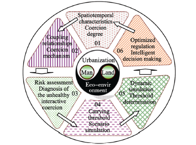
Figure 1 Schematic diagram of the logic framework of coupled effects

2.1 The key control elements and the spatiotemporal evolution characteristics associated with the interactive coercion between urbanization and the eco-environment

Our overall aim is to reveal the key control elements and spatiotemporal evolution characteristics of the interactive coercion between urbanization and the eco-environment in mega-urban agglomerations. Using advanced techniques such as remote sensing, GIS and sensor networks, we will perform systems analysis and spatial statistics to investigate the general dynamic characteristics of natural elements (water, soil, energy, ecology, climate and environment) and human elements (population, economy, society, infrastructure, policy, innovation and globalization). In detail, our objective is to reveal the coercion relationships between resources and the eco-environment, and the characteristic index of urbanization. Moreover, we also want to identify the supportive and restrictive effects of regional resources and eco-environmental elements on urbanization. Furthermore, through screening for key control elements, we will unveil their spatiotemporal evolution characteristics and interactive coercing effects on the eco-environment.
(1) To reveal the dynamic evolution characteristics of the coupled system between urbanization and the eco-environment, and of the responding indices in mega-urban agglomerations. At the county scale, we will identify spatiotemporal evolution characteristics of natural and human elements, and of the responding indices (Figure 2). Natural elements include land resource, water resource, energy, ecology and environment. Human elements refer to population, economy, infrastructure, society, innovation and policy. Meanwhile, in order to further reveal the various natural and human coercing effects, we will analyze the natural and human characteristics of agglomerations. Natural characteristics of agglomerations will include severe water and land shortages, severe pollution, high ecological sensitivity and risks, and high PM2.5 concentrations, while human characteristics of agglomerations will include high-speed economic growth, high-intensity economy, high population density, major regions of urbanization, concentrated domestic and foreign capital invest-ments, concentrated import and export trades and highly accelerated urbanization.
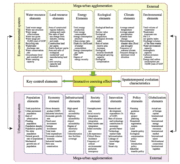
Figure 2 Schematic diagram of urbanization and eco-environmental elements, and the responding indices in mega-urban agglomeration (U and C are parameters respectively.)
(2) To analyze the spatiotemporal coupling characteristics between urbanization and the eco-environment in mega-urban agglomerations. First, based on the socioeconomic statistics over the years and spatial comparison analytic methods, we will analyze the dynamic change curve of the interactive promotional and coercing relationships of man-water, man-land, man-carbon, man-climate, man-energy, man-housing, man-biology and man-pollution in mega-urban agglomerations. In general, we want to further reveal the spatiotemporal evolution characteristics of the interactive coercion between human-centered urbanization and water-land-biology-centered eco-environments in mega-urban agglomerations. Second, we can elucidate the temporal characteristics in different periods and the spatial heterogeneity patterns of the interactive coercion relationships between urbanization and the eco-environment, which are driven by different factors in mega-urban agglomerations. Third, by applying structural equation modeling, we can quantify the supportive effects of resources and environmental elements on urbanization, and identify the advantageous aspects of resources and the environment, which promote urbanization. Lastly, we can quantitatively recognize the various restrictive effects of spatially different resources and environments on urbanization.
(3) To screen for key control elements in the interactive coercion between urbanization and the eco-environment, and their coercing effects. Based on the long-term socioeconomic data series, and resources and environmental survey data, we will use grey relational analysis, cluster analysis and principal component analysis to identify key internal and external control elements and their thresholds, which will have the most significant impact on the interactive coercion between urbanization and the eco-environment.
We will further identify the interactive coercion of the key internal and external control elements, construct the interactive coupling matrix, analyze the intensity of interactive coercions, quantify the spatiotemporal coercing characteristics of key control elements and reveal the ecological effects of the interactive coercion of key control elements in different urbanized areas, unveil the spatiotemporal evolution characteristics of key control elements and the interactive coerced eco-environmental effect, and provide fast and slow key control elements to regulate the interactive coercing threshold between urbanization and the eco-environment in mega-urban agglomerations and to assess potential risks to resources and the eco-environment during urbanization (Fang and Wang, 2013).

2.2 Interactive coerced local coupling and telecoupling mechanisms, and the pattern of interactive coercing effects between urbanization and the eco-environment

The urbanization system of mega-urban agglomeration includes 7 elements, which are population, economy, infrastructure, society, innovation, policy and globalization, while the eco-environment system includes 6 elements, which are water resource, land resource, energy, ecology, climate and environment. With respect to inter-regional (external) scale, intra-regional (internal) scale, and the scale of local couplings and telecouplings (Fang and Ren, 2017), we want to explore the interactive coercing and coupled relationships between the mega-urban agglomeration system and the ecosystem (Q = {U, C} = {(u1, u2, u3,..., ui), (c1, c2, c3,..., cj)}) under the influence of internal and external elements. These relationships can be defined as the dynamic coupled relationships between Ui and Cj, which will reveal the mechanism, stage, type and coupling pattern of the interactive coerced local couplings and telecouplings between the urban agglomeration system and ecosystem in mega-urban agglomerations.
(1) To reveal the mechanism of the interactive coerced local couplings and telecouplings between urbanization and the eco-environment (Figure 3). Our strategy is to use system coupling models such as correlation analysis, geographical weighted regression (GWR), panel cointegration test, vector error correction model (VECM), KSIM, spatial error model, and spatial lag model to analyze the data generated in the process of urbanization and eco-environmental evolution in mega-urban agglomerations over the past 35 years. At the scales of inter-region, intra-region and coupling, we will explore the mechanism of interactive coercion between urbanization and the eco-environment in mega-urban agglomerations under the influence of internal and external natural and human elements. On one hand, we will perform a “one-to-one” bidirectional analysis of the mechanism of interactive coerced local coupling and telecoupling between a single element of urbanization system and a single element of eco-environmental system, and calculate the interactive coupling coefficient of the element Ui of urbanization system to the element Cj of the eco-environmental system. On the other hand, we will conduct a “many-to-many” multidirectional analysis of the local coupling and telecoupling mechanisms of interactive coercion between urbanization and the eco-environment. We will build a coupling equation of urbanization and the eco-environment (UE = f (Ui - Cj); i = 1, 2, 3..., m; j = 1, 2, 3..., n) and draw coupling curves of interactive coercion between the urbanization system and eco-environmental system. Our results should provide a quantitative scientific basis to achieve harmonious man-water, man-land, man-energy, man-climate and man-carbon relationships.
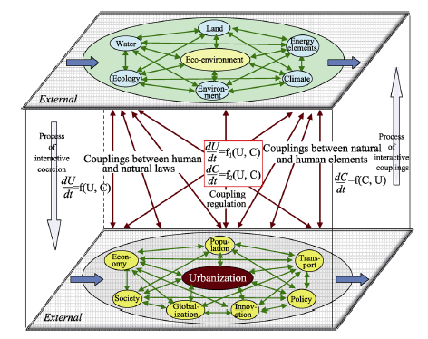
Figure 3 Schematic diagram of the interactive coupling mechanisms between urbanization and the eco-environment
(2) To define the stages and types of interactive coerced local couplings and telecouplings between urbanization and the eco-environment. Based on the study of the interactive coupling mechanisms of single elements and multiple elements, we will construct a model of the dynamic coupling relationships between urbanization and the eco-environment. By using the data generated in the process of urbanization and eco-environmental evolution in mega-urban agglomerations over the past 35 years, we will calculate the coupling degrees of 6 subsystems of the eco-environment and 7 subsystems of urbanization as well as the coupling degree between urbanization and eco-environmental systems. According to the coupling degrees and in reference to the theoretical evolution cycle of the interactive coupling between urbanization and the eco-environment, we can comprehensively evaluate the process, stages and types of couplings between urbanization and the eco-environment in mega-urban agglomerations under the influence of internal and external elements. This evaluation will determine the stages of interactive coercion between urbanization and the eco-environment based on both bidirectional and multidirectional elements, and the types of interactive coercion between urbanization and the eco-environment based on the identification of coupling stages.
(3) To quantitatively reveal the local coupling and telecoupling patterns of the interactive coercion between urbanization and the eco-environment. First, in reference to the research on mechanisms, stages and types of interactive coercion between urbanization and the eco-environment and the characteristics and laws of subsystems such as water resource, land resource, energy, ecology, climate and environment, we can analyze the coupled boosting effect, coupled reducing effect and coupled constant effect of these subsystems to identify the degree of eco-environment satisfaction to the degree of urbanization demand in mega-urban agglomerations. Second, we can also simulate the dynamic fluctuation process of interactive couplings between urbanization and the eco-environment to reveal the mechanism of stochastic fluctuation in interactive couplings between urbanization and the eco-environment (Fang and Qiao, 2005). Third, we can quantitatively develop the adaptive thresholding algorithm and explore the pattern of interactive couplings between urbanization and the eco-environment (Huang and Fang, 2003; Qiao and Fang, 2006). Fourth, using forewarning methods and forewarning signal models, we can forewarn of potential dangers and report warning signs that are present in the coupling process of urbanization and the eco-environment in mega-urban agglomerations. Lastly, we can also quantitatively unveil the coupling fission law, dynamic hierarchy law, stochastic fluctuations law, non-linear synergetic law, threshold value law and forewarning law of local couplings and telecouplings between urbanization and eco-environmental elements (Fang and Yang, 2006).

2.3 Determination of the severity of interactive coercion between urbanization and the eco-environment and risk assessment

Based on the analysis of the interactive coercion relationships between urbanization and the eco-environment, we can determine the coupling status of key control elements and the interactive coupling status of multiple elements. In addition, we can also identify the degree of dynamic couplings of interactive coercion and the degree of severity of interactive coercion. Furthermore, we can comprehensively evaluate the risks of interactive coercion and build a risk assessment system to predict the severity of interactive coercion between urbanization and the eco-environment in mega-urban agglomerations.
(1) To determine the coupling status of key control elements. Based on the available data, we can separately construct models of interactive coupling status between different single eco-environmental elements and urbanization, including man-water, man-land, man-energy, man-carbon, man-climate and man-ecology relationship (Fang and Bao, 2007). These models can clarify the mutually beneficial or detrimental relationships between urbanization and resources and the eco-environment, and quantitatively express the degree of coercion, synchronicity and dependency, and estimate the trend of the aforementioned coupling status change.
(2) To determine the integrated interactive coupling statuses of multiple elements. Based on the models of interactive coupling status of single elements, we can further establish integrated models of the interactive coupling statuses between urbanization and eco-environmental elements including water, land, climate, energy and carbon in mega-urban agglomerations, and thus create an integrated system of the interactive coupling statuses between urbanization and the eco-environment. Moreover, through multiple approaches, we can analyze the integrated interactive coupling relationships among multiple elements, and quantify the degrees of integrated couplings, coercion and coordination between urbanization and resources and environment (Fang and Xie, 2010; Bao and Fang, 2006; Fang and Sun, 2005). Three analytical approaches include artificial neural network models to determine the integrated interactive coupling statuses of multiple elements, ensemble empirical mode decomposition (EEMD) to analyze the synchronicity between multiple temporal resolutions and the interactive coupling statuses of multiple elements, and computable general equilibrium (CGE) model to define the inherent relationships between urbanization and resources and environmental elements.
(3) To identify the degree of dynamic coupling and the severity of interactive coercion, and comprehensively evaluate the risk of interactive coercion. We can treat a mega-urban agglomeration as a living organism and view its metabolic processes and the ecosystem services provided by the agglomeration as ‘vital signs’. Combined with the degree of coupling of interactive coercion, the severity and causes of “urban agglomeration diseases” can be determined. Specifically, the exergy analysis theory can be introduced into studies of urban agglomeration metabolism (Fang et al., 2017). The net exergy yield rate (NEYR), environment load rate (ELR) and exergy exchange rate (EER) can be used to represent the vitality, structure and resilience of urban systems, respectively. Additionally, based on the simulation of ecosystem services of urban agglomerations, and the results of supply and demand analysis, as well as the structural and functional eco-thermodynamic indices of urban agglomerations, such as metabolic utility, metabolic efficiency, metabolic intensity, metabolic eco-coercion and metabolic environmental impacts, we can comprehensively assess the severity, duration and future trends, and analyze the causes of “urban agglomeration diseases” by establishing the baseline and threshold.
(4) To establish a risk assessment system of the interactive coercion between urbanization and the eco-environment in mega-urban agglomerations. We can view the interactive coercion between urbanization and the eco-environment as the source of risk in an agglomeration, with both living and non-living characteristics. According to the degree and duration of coercion, we can analyze the degree to which an agglomeration is exposed to the coercion. Moreover, based on the urban metabolic analysis from eco-thermodynamics and the supply and demand status of ecosystem services, we can evaluate the health status as well as the vulnerability and the resilience of an urban system. Furthermore, using the Bayesian statistical method, we can decipher the interactive coercion between urbanization and the eco-environment into different types of risks, including social security, resource security and eco-environmental risks, and calculate the probabilities of these risks. Lastly, according to the magnitude and controllable degree of risks in agglomerations, we can establish a forewarning system for real-time monitoring of health status, and forewarn the signs and risks of “urban agglomeration diseases”, and record the long-term health status of urban agglomerations.

2.4 The dynamic simulation and elastic threshold of interactive coupling between urbanization and the eco-environment

In reference to the results of the spatiotemporal characteristics, local coupling and telecoupling mechanisms and patterns, and risk assessment of the interactive coercion between urbanization and the eco-environment in mega-urban agglomerations, and on the basis of the system dynamics model, we can reconstruct a system dynamics model of the interactive coercion between urbanization and the eco-environment in mega-urban agglomerations with multi-element, multi-scale, multi-scenario, multi-function, multi-module and multi-agent integrations. Moreover, we will validate the aforementioned spatiotemporal coupling dynamics model, and simulate the thresholds and construct the threshold model of interactive coercion between urbanization and the eco-environment. Consequently, we will build a systematic scientific platform for the quantitative study of urbanization in mega-urban agglomerations. Through adjustments and repeated simulation of critical thresholds, the mid-term to long-term multi-scenario scheme for mega-urban agglomerations can be constructed, which will provide a scientific basis for decision-making to achieve coordinated development of urban agglomerations. Moreover, these critical thresholds can serve as reference parameters for decision-making regarding economic and social development goals, the operation of the economy-population-urban agglomeration system, and the degree of resources and environmental protection in the forthcoming developmental processes of mega-urban agglomerations (Tan et al., 2014; Zhang et al., 2016; Wang et al., 2016).
(1) To construct the system functional modules of interactive coercion between urbanization and the eco-environment. Using models of the carrying capacity threshold and the degree of saturation of ecology-production-life space, we can construct 8 different system functional modules, including water resource and eco-environment, land resource, energy and climate, population and urban system, economic globalization and industrial development, construction and investment of urban and rural areas, transport and logistics, and finally, science and technology innovation, and macro policy. In addition, we can study the core variables and the mathematical expression of each module, use nesting principles to organize these functional modules, and construct a conceptual framework for the dynamics model of the interactive coercion between urbanization and the eco-environment in mega-urban agglomerations (Figure 4).
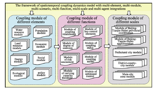
Figure 4 The framework of spatiotemporal coupling system dynamics model with multi-element, multi-module, multi-scenario, multi-function, multi-scale and multi-agent integrations
(2) Dynamics analysis of the key control elements in interactive coercion between urbanization and the eco-environment. By means of regression analysis and a macroeconomic model, and using water resource as the key control element, we can construct the functional module of water resource and the eco-environmental system in the presence of interactive coercion between urbanization and the eco-environment. Moreover, using land resource as the key control element, we will adopt cellular automata (CA) and a multi-agent model to construct the functional module of urbanization and land use change. This model can be used to simulate the expansion of constructional land in mega-urban agglomerations based on single-center, bi-center and multi-center schemes, and to acquire the relevant parameters and threshold of the interaction between land use change and urbanization. Furthermore, the Stochastic Impacts by Regression on Population, Affluence and Technology (STIRPAT) model can be used to simulate the spatiotemporal impacts of quantification of pollutants, affluence and technology on urban energy use and carbon emission, and carry out the life cycle analysis (LCA) of mega-urban agglomerations.
(3) To construct the spatiotemporal coupling system dynamics model with multi-element, multi-scale, multi-scenario, multi-function, multi-module and multi-agent integrations. Based on the existing system dynamics model of urbanization, we will consider key eco-environmental elements, such as water resource, land resource and energy, as the key control elements in the urbanization process of mega-urban agglomerations. Through this approach, we can depict the flowchart of the causal relationship and feedback loop of the spatiotemporal coupling system dynamics model of the interactive coercion between urbanization and the eco-environment with multi-element, multi-scale, multi-scenario, multi-function, multi-module and multi-agent integrations, and we can also reconstruct the aforementioned model.
(4) To conduct computational experiments and determine the threshold of interactive couplings between urbanization and the eco-environment. We will conduct a preliminary simulation of the interactive coercion between urbanization and the eco-environment using the spatiotemporal coupling system dynamics model, test the validity of the model, simulate the thresholds and construct a model of the threshold. Additionally, we will also analyze the interactive coercion between urbanization and eco-environment, and the unhealthy status potential of the urban and eco-environmental systems. The model parameters will be modified and simulated repeatedly until the requirements are fulfilled. Moreover, we will nest and integrate modules, and construct a systematic scientific platform for the quantitative study of urbanization in mega-urban agglomerations.
(5) To conduct scenario simulation of the interactive coupling processes and patterns between the urbanization of mega-urban agglomerations and the eco-environment. According to the basic data on mega-urban agglomerations and the goals of counties in the “13th Five-Year Plan” (2016-2020), we will design multiple experimental scenarios, repeat experiments and calculations, and produce a scenario plan of the process of urbanization in mega-urban agglomerations that can adapt to the thresholds, and resources and environmental carrying capacity. In addition, we will be able to a conduct long-term (2030-2050) forecast and simulation in the interactive coercion process between urbanization and the eco-environment through adjustments to coercion thresholds and repeated simulations, which will ultimately form a mid-term and long-term multi-scenario plan for the development of mega-urban agglomerations.
(6) We will adopt a system dynamics model for resources and the environment to construct systems of forewarning indices and forewarning signs for the interactive coercion between urbanization and the eco-environment. In detail, we can determine the contribution rates of forewarning indices as well as simulate the social and economic development goals and the degree of resources and environmental protection in the recent developmental process of mega-urban agglomerations. Additionally, we can determine the degree of unhealthy urbanization caused by the deviation from the forewarning indices of the coercion between the social and economic development goals and the degree of resources and environmental protection. Collectively, the forewarning response system for the interactive coercion between urbanization and the eco-environment in mega-urban agglomerations can provide a scientific basis for government decision-making.

2.5 Research and development, and model selection for the intelligent decision support system of the interactive coupling between urbanization and the eco-environment (UDSS)

Based on space simulation and GIS technology, we can build an integrated intelligent decision support system for the interactive couplings between urbanization and the eco-environment in mega-urban agglomerations (UDSS). The UDSS has the distinctive features of high intelligence, high visualization ability and high sensitivity (Figure 5). By combing the UDSS with typical research areas, we can simulate the impacts of resources and environmental protection, and the relevant optimized regulations to determine the appropriate population sizes, space and economy in an agglomeration at different stages, and we can also propose a sustainable development model and a highly efficient growth model based on resource restrictions and eco-environmental capacity (Fang et al., 2011b). In this regard, our models should provide a systematic scientific decision-making basis for the promotion of healthy and sustainable development of urban agglomerations.
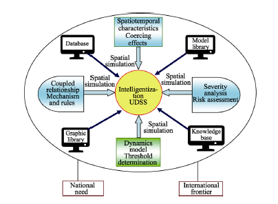
Figure 5 Schematic diagram of the intelligent decision support system for optimizing the interactive couplings between urbanization and the eco-environment
(1) To implement multi-scale spatiotemporal simulations of the socioeconomic and eco-environmental elements in mega-urban agglomerations. We can obtain information on natural elements (water, land, energy, ecology, climate and environment) in a wide range of spaces by applying spatialization technologies including remote sensing, GIS, sensor networks, spatial distribution information generated from big data, the method of spatial difference and scale conversion of spatial grid, and surface modeling. Moreover, through the spatialization of the data on human elements (population, economy, society, infrastructure, technology innovation, policy and globalization), we can obtain a wide range of continuous spatial information for these elements. Using the above methods, we can achieve standardization of the multi-source data on urbanization elements as well as the spatialization features and the visualized expression of the spatiotemporal dynamics of socioeconomic and eco-environmental elements. Additionally, under the unified spatiotemporal frame, we can integrate various methods of visualized expressions such as spatial graphs, statistical graphs, flow diagrams and three-dimensional (3D) graphs to show the spatial distribution and statistical results of socioeconomic and eco-environmental elements related to urbanization. In addition, simulated results of urbanization under multiple scenarios can also be generated. Combined with space-time prism, we can achieve four-dimensional multi-scale simulations.
(2) To conduct the visualized scenario simulation of the interaction between urbanization and the eco-environment within the restriction of eco-environmental elements. We will adopt methods such as hierarchy decomposition, cooperation correlation and cascade interaction to construct the coupling model library with a self-organization feature by the standardized assembly method, which can provide highly effective model library support for the visualized scenario simulation of the interaction between urbanization and the eco-environment. Moreover, by using asynchronous evolution, cooperative interaction and feedback network, we will discuss the scenario simulation mechanism of dynamic urban development under multiple interactions and feedbacks. Further, we can complete the scenario simulations in the presence of multiple spatiotemporal dynamic restrictions from the complex eco-environmental elements, and the asynchronous development and asynchronous feedbacks from multi-scale cities. Lastly, by means of spatiotemporal scale conversion and process decomposition, we can explore how to achieve coupled restrictive effects of resources and the environment at the multi-temporal and multi-spatial scales, and also how to achieve dynamic visualized scenarios of the evolution and feedback of urbanization elements.
(3) To develop an intelligent decision support system of the interactive coupling between urbanization and the eco-environment. We will construct an intelligent decision support system of the interaction between urbanization and the eco-environment, which will integrate spatialized environmental elements, systematic dynamic simulations and multi-scale optimized decision-making modules. This system will include a four-dimensional simulation module with multiple scales of population, space and economic size, a scenario simulation module with multi-scale interactions and feedbacks, and a module based on the capacity limit of resources and the environment, and sustainable development. Additionally, we also want to achieve accurate estimation of the multi-scale population and economic sizes of mega-urban agglomerations, achieve simulation of the interactive coercion between eco-environment and urbanization at the scales of county, prefectural city, urban agglomeration and province, and generate an optimized model for the development of highly efficient and sustainable urban agglomerations. Finally, we hope to provide a quantitative decision-making platform for the construction of resource-conserving, environmentally-friendly, ecologically-sustainable and intelligent urban agglomerations.

3 Conclusions and discussion

Mega-urban agglomerations are strategic core areas for domestic economic development and the main regions of new urbanization in China. They also play important roles in shifting the global economic center of gravity to China. However, unsustainable high-density aggregation, high-speed expansion, high-intensity pollution and high-risk threats to resources and the environment are emergent in the development of mega-urban agglomerations. With unsustainable urban developments and severe eco-environmental problems, these regions carry the “most affected areas” distinction and face increasing coercion from resources and the environment in their development. How to coordinate the relationships between urbanization and eco-environment in mega-urban agglomerations is a complex problem that needs to be urgently solved by both academia and governmental decision-making departments. The coordinated development of urbanization and the eco-environment has become a global strategic issue. However, research in this field is still at an early stage and has yet to draw much attention from researchers.
Current practical experience on the development of global urbanization shows that urbanization has been producing severe coercing effects and far-reaching influence on the eco-environment. Moreover, there are extremely complex non-linear coupling relationships between urbanization and the eco-environment. As such, research on the interactive coupled effects between urbanization and the eco-environment will be frontiers and high-priority in Earth system science and sustainability science in the next decade. In addition, these research topics will greatly attract the attention of international organizations. Nevertheless, in the field of interactive couplings between urbanization and the eco-environment, much research is still urgently required to achieve sustainable development of mega-urban agglomerations.
In order to theoretically analyze the interactive coupled effects between urbanization and the eco-environment in mega-urban agglomerations, we need to construct a theoretical framework of the interactive couplings between urbanization and the eco-environment. Based on the framework, we can further analyze the non-linear coupled relationships and coupling characteristics of the interaction between various natural and human elements in mega-urban agglomerations, identify the coercing intensities of the interactions between various internal and external elements, present the mechanisms and patterns of local couplings and telecouplings under the influence of internal and external key control elements, summarize the theories of the interactive couplings between urbanization and the eco-environment, construct a spatiotemporal coupling dynamics model with multi-element, multi-scale, multi-scenario, multi-function, multi-module and multi-agent integrations, and develop an optimized intelligent control and decision-making support system for the sustainable development of mega-urban agglomerations. Through the aforementioned efforts, we will be able to propose solutions to mega-urban agglomeration related problems and maintain its sustainable development.
In order to methodically analyze the interactive coupled effects between urbanization and eco-environment in mega-urban agglomerations, it is necessary to consider a mega-urban agglomeration as an open, complex giant system. Based on the establishment of a shared unified standardized database, we can study the interactive couplings between urbanization and the eco-environment with multi-element, multi-target, multi-module and multi-scenario integrations, and also with big data analysis. Moreover, we will build a framework of the interactive couplings between urbanization and the eco-environment with multi-scale, multi-technology and multi-agent integrations. Overall, we will propose an optimized solution according to the following technical route, which sequentially consists of analyzing the spatiotemporal evolution characteristics, determining the key control elements, identifying the coupling relationships, revealing the mechanisms of coercion, discovering the coupling laws, screening for controlling variables, calculating the thresholds, conducting the tests to regulate and control variables, completing the scenario simulations, proposing the optimized solutions, and finally achieving the national goals.
Considering the extreme complexity of sustainable development of mega-urban agglomerations, we believe that traditional urban geography is not sufficient to reveal the cross-city, cross-boundary, cross-field, cross-disciplinary and even cross-country characteristics of mega-urban agglomerations. The basic functions of cities have exceeded the traditional social and economic functions, and have started to more frequently interact with eco-environmental elements. As such, it is impossible to study the development of mega-urban agglomerations within a single discipline, and hence it is urgent to apply integrated interdisciplinary approaches to realize multi-element couplings, multi-scenario simulations, multi-risk forewarnings and multi-goal decision-makings in the sustainable development of agglomerations, and also to advance the study of human geography to the next level.

The authors have declared that no competing interests exist.

[1]
Bao Chao, Fang Chuanglin, 2006. Study on the quantitative relationship between urbanization and water resources utilization in the Hexi Corridor.Journal of Natural Resources, 21(2): 301-310. (in Chinese)Based on the statistical data from the year 1985 to 2003,we analyzed the quantitative relationship between urbanization and total water utilization,water utilization benefits,and per capita water utilization in the Hexi Corridor,including its five districts and three major inland river basins.And the relationship model between them was constructed.Results show that,in the Hexi Corridor,the relationship between urbanization and total water utilization can be simulated by a logarithmic curve.If this condition continues,rapid urbanization in the Hexi Corridor will face up higher water stress,so the development mode of water resources and urbanization at should be adjusted,and the fresh water withdraw should be decreased step by step.The relationship between urbanization and water utilization benefits can be simulated by a linear equation.Where the urbanization and industrialization level is higher,the water utilization benefits are higher.So the Hexi Corridor should accelerate the process of urbanization and industrialization to obtain higher water utilization benefits.The relationship between urbanization and per capita water utilization is complex,but it obviously relates to the total quantity of water resources.We also found that scarce water resources obviously restricted the process of urbanization in the Hexi Corridor.And the water resources constraint intensity is the biggest in the eastern part,where water resources are the scarcest.The process of urbanization is faster in the middle part than in the eastern.However,the middle part consumed much more water resources.The western part has the highest urbanization level and water utilization benefits,but its per capita water utilization is also the highest.Therefore,the Hexi Corridor should construct an intensive water resources utilization system to lessen the water resources constraint on the process of urbanization.It is also an important task to carry out the strategy of urbanization and the great development of west China.

DOI

[2]
Cao S, Hu D, Zhao Wet al., 2017. Monitoring spatial patterns and changes of ecology, production, and living land in Chinese urban agglomerations: 35 years after reform and opening up, where, how and why?Sustainability, (9): 766.Chinese urban agglomeration (UA) has gradually become a new world economic center and the strategic region of the “The Belt and Road Initiatives”. The spatial patterns and variations of ecology–production–living land (EPL) profoundly affect UA’s development and its ecological environment. Unfortunately, scientific understanding about the trajectories, patterns and drivers of EPL changes in Chinese urban agglomerations (UAs) since reform and opening up is still very limited. The aim of this paper was to monitor those characteristics during the last 35 years. Here, we proposed a new classification system of EPL, including ecology land (EL), industrial production land (IPL), agricultural production land (APL), urban living land (ULL) and rural living land (RLL) due to Chinese urban–rural dual structure. Then, we extracted EPL land from the Chinese LUCC product, which is the recently released remote sensing data product of high resolution spatial land use data in China at national level. Furthermore, we analyzed the spatial-temporal trajectories and driving factors of EPL for Chinese UAs during 1980–2015. The results showed that: (1) ULL and IPL in Chinese UAs were increased rapidly, while EL and APL were seriously decreased. (2) The growth patterns of ULL and IPL had shown a spatial heterogeneity. As to different regional UAs, the expansion rates of ULL and IPL ranked from high to low were as follows: eastern, central, western, and northeastern UAs. (3) National policies, population, and economy dominated the spatial-temporal changes of EPL in Chinese UAs. (4) The multi-planning integration in the structure of land use should be strengthened at UA-scale.

DOI

[3]
Chauvin J P, Glaeser E, Ma Yet al., 2017. What is different about urbanization in rich and poor countries? Cities in Brazil, China, India and the United States.Journal of Urban Economics, 98: 17-49.Are the well-known facts about urbanization in the United States also true for the developing world? We compare American metropolitan areas with analogous geographic units in Brazil, China and India. Both Gibrat- s Law and Zipf- s Law seem to hold as well in Brazil as in the U.S., but China and India look quite different. In Brazil and China, the implications of the spatial equilibrium hypothesis, the central organizing idea of urban economics, are not rejected. The India data, however, repeatedly rejects tests inspired by the spatial equilibrium assumption. One hypothesis is that spatial equilibrium only emerges with economic development, as markets replace social relationships and as human capital spreads more widely. In all four countries there is strong evidence of agglomeration economies and human capital externalities. The correlation between density and earnings is stronger in both China and India than in the U.S., strongest in China. In India the gap between urban and rural wages is huge, but the correlation between city size and earnings is more modest. The cross-sectional relationship between area-level skills and both earnings and area-level growth are also stronger in the developing world than in the U.S. The forces that drive urban success seem similar in the rich and poor world, even if limited migration and difficult housing markets make it harder for a spatial equilibrium to develop.

DOI

[4]
Clark W C, 2007. Sustainability science: A room of its own.Proceedings of the National Academy of Sciences, 104: 1737.Not Available

DOI PMID

[5]
Committee on New Research Opportunities in the Earth Sciences at the National Science Foundation(CNROES), 2014. New Research Opportunities in the Earth Science. Beijing: Science Press. (in Chinese)

[6]
Fang Chuanglin, 2014a. China’s New Urbanization Development Report. Beijing: Science Press. (in Chinese)

[7]
Fang Chuanglin, 2014b. Progress and the future direction of research into urban agglomeration in China.Acta Geographica Sinica, 69(8): 1130-1144. (in Chinese)Urban agglomeration has been the inevitable result of China's rapid industrialization and urbanization over the last 30 years. Since the early 2000 s,urban agglomeration has become the new regional unit participating in international competition and the division of labor. China has declared urban agglomeration the main spatial component of new types of urbanization over the next decade as clarified at the first Central Urbanization Working Conference and in the National New-type Urbanization Plan(2014?2020). However,research on urban agglomeration remains weak and needs to be strengthened. From 1934 to2013,only 19 papers published in Acta Geographica Sinica contained the theme of urban agglomeration(0.55% of the total number of articles published) and the first paper on urban agglomeration appeared less than 10 years ago. Despite a small number of divergent studies,this work has contributed to and guided the formation of the overall pattern of urban agglomeration in China. For example,spatial analyses have promoted the formation of the fundamental framework of China' s urban agglomeration spatial structure and guided the National New-type Urbanization Plan; spatial identification standards and technical processes have played an important role in identifying the scope and extent of urban agglomeration;serial studies have facilitated pragmatic research; and problems with the formation and development of urban agglomeration have provided a warning for future choices and Chinese development. Future research into urban agglomeration in China should(1) review and examine new problems in China's urban agglomeration options and cultivation;(2) critically consider urban agglomeration when promoting the formation of the 5+9+6 spatial pattern;(3)rely on urban agglomeration to construct new urbanization patterns such as 'stringing the agglomerations with the axis,supporting the axis with the agglomerations'; and(4) deepen national awareness about resources,environment effects and environmental carrying capacity in high density urban agglomerations,management and government coordination innovation,the construction of public finance and fiscal reserve mechanisms,the technical regulation of urban agglomeration planning,and standards for identifying the scope and extent of urban agglomeration.

DOI

[8]
Fang Chuanglin, 2015. Scientific selection and grading cultivation of China’s urban agglomeration adaptive to new normal in China.Bulletin of the Chinese Academy of Sciences, 30(2): 127-136. (in Chinese)The urban agglomeration is a city group of highly integrated and regional co-coordinating, which has experienced four extension processes from the city to metropolitan area, metropolitan circle, urban agglomeration, then to metropolis. Urban agglomeration is the main land of One Belt And One Road(OBAOR)where the world economy focus will transfer to, the main part of the new urbanization, and the most dynamic core area with the highest potential in the economic development pattern today and future. But a series of"city disease"should be solved, such as"arbitrary range, strive for grandiose projects, spoil things by excessive enthusiasm, out of thin air, knock together", et al. These problems embodied in the following forms: the strategic position of urban agglomeration has been exaggerated overvalued, appeared"only group theory"in the new urbanization; spatial scopes of urban agglomeration expand excessively, and violate the basic purpose of urban agglomerations for state construction; urban agglomeration scopes depend too much on subjective will, and break away from the basic stand of urban agglomerations; the choice of cultivation of urban agglomeration makes endless concessions to local interests and affects the nation's overall strategic security structure; and urban agglomerations become a sensitive area and"problem"area that ecological environment problems centralized in,such as fog and haze. To solve these problems, we suggest that selecting urban agglomeration should be in accordance with the scientific standard and objective law and cultivating urban agglomeration step by step, and scientifically recognizing and understanding the objective standards and laws of nature on urban agglomeration development; distinguishing the essential difference between urban agglomeration and city cluster, avoiding confusions among them in government documents and academic research; cultivating China's urban agglomeration in large, medium, and small gradient scientifically, and constructing five big national-level urban agglomerations, nine medium regional-level urban agglomerations, and six small local-level urban agglomerations; making urban agglomeration planning adaptive to the environmental resource bearing capacity; innovating public finance system and public fiscal reserve mechanism of urban agglomeration; playing the significant role of market mechanism in urban agglomeration development, and guiding urban agglomeration comply with the new normal of economic development to realize healthy and stable development.

[9]
Fang Chuanglin, Bao Chao, 2007. Management implications to water resources constraint force on socio-economic system in rapid urbanization: A case study of the Hexi Corridor.Water Resources Management, 21: 1613-1633.As water has become the shortest resources in arid, semi-arid and rapid urbanization areas when the water resources utilization has approached or exceeded its threshold, water resources system slows down the socio-economic growth rate and destroys the projected targets to eradicate poverty and realize sustainable development. We put forward the concept of Water Resources Constraint Force (WRCF) and constructed a conceptual framework on it. Conceptual models on the interactions and feedbacks between water resources and socio-economic systems in water scarce regions or river basins indicate that, if the socio-economic system always aims at sustainable development, WRCF will vary with a normal distribution curve. Rational water resources management plays an important role on this optimistic variation law. Specifically, Water Demand Management (WDM) and Integrated Water Resources Management (IWRM) are considered as an important perspective and approach to alleviate WRCF. A case study in the Hexi Corridor of NW China indicates that, water resources management has great impact on WRCF both in Zhangye and Wuwei Region, and also the river basins where they are located. The drastic transformation of water resources management pattern and the experimental project - Building Water-saving Society in Zhangye Region alleviated the WRCF to some extent. However, from a water resources management view, WRCF in Zhangye Region still belongs to the severe constraint type. It will soon step into the very severe constraint type. In order to shorten the periods from the very severe constraint type finally to the slight constraint type, WDM and IWRM in the Hei River Basin should be improved as soon as possible. However, in the Shiyang River Basin, WRCF belongs to the very severe constraint type at present due to poor water resources management in the past. Though the socio-economic system adapted itself and alleviated the WRCF to some extent, the Shiyang River Basin had to transform the water supply management pattern to WDM, and seek IWRM in recent years. It is concluded that WDM and IWRM is a natural selection to alleviate the WRCF on the socio-economic system and realize sustainable development.

DOI

[10]
Fang Chuanglin, Bao Chao, Qiao Biao et al., 2008. The Process of Urbanization and Ecological Environment Effect. Beijing: Science Press. (in Chinese)

[11]
Fang Chuanglin, Guan Xingliang, 2011. Comprehensive measurement and spatial distinction of input-output efficiency of urban agglomerations in China.Acta Geographica Sinica, 66(8): 1011-1022. (in Chinese)Urban agglomerations in China which perform a vital role in distribution of productive forces are the most dynamic and potential core area in future economic development, and are the key and optimized development districts in the division of main-function zones. However, while driving up rapid economic growth of urban agglomerations, high-intensity interaction caused by high-density aggregation also contributed to high-risk threats to natural environment. How do we assess the effect of high-density urban agglomerations? Accordingly, from the perspective of input and output efficiency, this paper established input and output efficiency indicator system of urban agglomerations, using CRS model, VRS model and Bootstrap-DEA, and measured the changing trend and spatial differentiation of input and output efficiency of urban agglomerations in China comprehensively. Results showed that input and output efficiency of urban agglomerations in China is low and slipping. In 2002 and 2007, comprehensive input and output efficiency of urban agglomerations in China was respectively 0.853 and 0.820, which dropped by an average of 0.033. Similarly, technical and scale efficiency of urban agglomerations in China is low and slipping; Input and output efficiency of urban agglomerations in China modified by Bootstrap-DEA model is lower but more reliable and effective. Input and output efficiency of urban agglomerations decreases gradually from the eastern region to the central and western regions of China. In 2002 and 2007, comprehensive input and output efficiency, technical efficiency and scale efficiency of urban agglomerations in eastern and central regions were higher than those in the western region, which was correlated with the regional economic development pattern in China. Otherwise, technical and production efficiency of urban agglomerations also decreases gradually from the eastern to the central and western regions. This study aims to provide a quantitative basis for assessing the effect of high-density urban agglomerations in China, and further lay a solid foundation for decision-making of improving input and output and spatial agglomeration efficiency of urban agglomerations in China.

DOI

[12]
Fang C L, Liu H M, Li G D, 2016. International progress and evaluation on interactive coupling effects between urbanization and the eco-environment.Journal of Geographical Sciences, 26(8): 1081-1116.Global urbanization is exerting severe stress and having far-reaching impacts on the eco-environment, and yet there exists a complex non-linear coupling relationship between the two. Research on the interactive coupling effect between urbanization and the eco-environment will be a popular area of study and frontier in international earth system science and sustainability science in the next 10 years, while also being a high-priority research topic of particular interest to international organizations. This paper systematically collates and summarizes the international progress made in research on interactive coupling theory, coupling relationships, coupling mechanisms, coupling laws, coupling thresholds, coupling models and coupling optimization decision support systems. The research shows that urbanization and eco-environment interactive coupling theories include the Kuznets curve theory, telecoupling theory, planetary boundaries theory, footprint family theory and urban metabolism theory; most research on interactive coupling relationships is concerned with single- element coupling relationships, such as those between urbanization and water, land, atmosphere, climate change, ecosystems and biodiversity; the majority of research on interactive coupling mechanisms and laws focuses on five research paradigms, including coupled human and nature systems, complex social-ecological systems, urban ecosystems, social-economic-natural complex ecosystems, and urbanization development and eco-environment constraint ring; the majority of interactive coupling simulations use STIRPAT models, coupling degree models, multi-agent system models and big data urban computer models; and research has been carried out on urbanization and eco-environment coupling thresholds, coercing risk and optimal decision support systems. An objective evaluation of progress in international research on interactive coupling between urbanization and the eco-environment suggests that there are six main research focal points and six areas lacking research: a lot of research exists on macroscopic coupling effects, with little research on urban agglomeration and scale coupling effects; considerable research exists on sin-gle-dimension coupling effects, with little on multiple-dimension coupling effects; a great deal exists on "one-to-one" dual- element coupling effects, with little on "many-to-many" multiple-element coupling effects; a lot exists on positive feedback coupling effects, and little on negative feedback coupling effects; a great deal exists on empirical coupling effects, and little on theoretical coupling effects; a great deal exists on the use of simple quantitative methods, and little on using integrated simulation methods. Future studies should focus on coupling effects between urbanization in urban agglomerations and the eco-environment, spatial scale coupling effects, multi-dimensional coupling effects, telecoupling effects, "one-to-many" and "many-to-many" element coupling effects, and positive and negative feedback coupling effects. There is also a need to strengthen the development and application of dynamic models for multi-element,-scale,-scenario,-module and-agent integrated spatiotemporal coupling systems and further improve theoretical innovations in coupling effect research and integrate and form complete and diverse coupling theoretical systems.

DOI

[13]
Fang Chuanglin, Liu Xiaoli, 2010. Comprehensive measurement of carrying degrees of resources and environment of the city clusters located in central China.Chinese Geographical Science, 20(3): 281-288.Studying the carrying capacity of resources and environment of city clusters in the central China has important practical guidance significance for promoting the healthy, sustainable and stable development of this region. According to their influencing factors and reciprocity mechanism, using system dynamics approaches, this paper built a SD model for measuring the carrying capacity of resources and environment of the city clusters in the central China, and through setting different development models, the comprehensive measurement analysis on the carrying capacity was carried out. The results show that the model of promoting socio-economic development under the protection of resources and environment is the optimal model for promoting the harmony development of resources, environment, society and economy in the city clusters. According to this model, the optimum population scale of the city clusters in 2020 is 42.80 10 6 persons, and the moderate economic development scale is 22.055 10 12 yuan (RMB). In 1996-2020 the carrying capacity of resources and environment in the city clusters took on obvious phase-change characteristics. During the studied period, it is basically at the initial development stage, and will come through the development process from slow development to speedup development.

DOI

[14]
Fang Chuanglin, Mao Qizhi, 2015. The New Exploration of China’s Urban Agglomeration Selection and Cultivation. Beijing: Science Press. (in Chinese)

[15]
Fang C L, Ren Y F, 2017. Analysis of emergy-based metabolic efficiency and environmental pressure on the local coupling and telecoupling between urbanization and the eco-environment in the Beijing-Tianjin-Hebei urban agglomeration.Science China Earth Sciences, 60(6): 1083-1097.

DOI

[16]
Fang Chuanglin, Qiao Biao, 2005. Optimal thresholds of urban economic development and urbanization under scarce water resources in arid northwest China.Acta Ecologica Sinica, 25(9): 2413-2422. (in Chinese)Under the constraint of water resource, the threshold for urbanization level in arid area refers to the utmost portion of nonagricultural population transformed from agricultural population in the total population. It is reached by constructing economic capabilities to accommodate a certain amount of transformed nonagricultural population while ensuring certain speed and the scale of economic development and basic environmental construction. This paper, using the arid area of Hexi Corridor in Gansu province as a case study, analyzes the total economic amount of urban development and the corresponding thresholds of urbanization level under the constraint of water resource. The results show that, if there is no interregional water transferring, the upper limit threshold of gross water requirement in Hexi Corridor should be 7.81 10~9m~3 in the coming 30 years, for which, the proportion of ecological water, productive water and domestic water will be adjusted to 13.2:83.5:3.3. The GDP corresponding to the gross water requirement is 1.81 10~11 yuan, and the fastest average annual growth rate can reach 6.91%. The adjusted and optimized proportion threshold of primary industry, secondary industry and tertiary industry is 18.99:47.20:33.81. With the multiple restrictions of gross water requirement threshold, economic aggregate threshold, economic increase threshold, water use structure and industry structure optimization threshold, and economic growth rate not less than 7%, agricultural water reduction by 9.12 10~8m~3 with a speed of 0.61%, the proportion of ecological water not less than 13%, we project that the total population threshold should be 5.82 10~6 persons, nonagricultural population threshold should be 2.05 10~6 persons, and urbanization level threshold should be 35.14% in the following 30 years which is just the average urbanization level of China in 2001.If water importation reaches 1.31 10~9m~3, the threshold for urbanization level can reach 47.17%. In order to verify the ensuring of the economic development for the threshold of urbanization level under the constraint of water resource, the paper introduces three economic indexes: gross domestic product per capita, added values of secondary industry and tertiary industry per nonagricultural population and added value of primary industry per agricultural population. The results show that, gross water requirement threshold, economic aggregate threshold, economic increase threshold and urbanization level threshold have great variance among different cities due to the varied water scarcity, water-fetching conditions, developmental character, developmental phase, economic strength and developmental foreground of each city.

DOI

[17]
Fang Chuanglin, Song Jitao, Lin Xueqin et al., 2010. Theory and Practice on the Sustainable Development of China’s Urban Agglomeration. Beijing: Science Press. (in Chinese)

[18]
Fang Chuanglin, Sun Xinliang, 2005. Coupling effects between water resources change and urbanization process in Hexi Corridor of Northwest China.Resources Science, 27(2): 2-8. (in Chinese)It is vital to accelerate the process of urbanization in arid area of Hexi corridor of Gansu province in the development of west China, as urbanization in the area could 1) accelerate the process of industrialization and realize economic sustainable development; 2) help to construct a well-off society in an all-round way; 3) absorb more rural surplus labor forces; 4) promote conversion of slope cropland to woodland and grassland, and 5) carry out ecological migration strategy. However, the process of urbanization in the area China is restricted by both scarce water resources and irrational structure of water utilization. The paper aims to analyze coupling effects between water resources change and urbanization process in arid area of Hexi corridor of Gansu province in Northwest China. The results show that water shortage in the cities of Hexi corridor is caused by an irrational water utilization structure, not the total quantity of water resources, therefore, it is a case of relative shortage. The first driving force of urbanization is thus transportation and other resource, rather than water resources; the first restricting factor causing a slow process of urbanization is a weak industrial centralization, rather than water resources. It is forecasted that, under the restriction of multiple factors, only 8710~4 peasants can migrate to the cities, and the urbanization target can only reach 35% in 2030. It is found that with the increase of urbanization by one percent, water consumption will increase by 0.9110~8m~3. From 1985 to 2030, when the urbanization standard increases at an intervals of five percent, the urban water consumption will increase at a large extend, and the difficulties in getting water resources and the cost of urban water utilization will be increasing. According to the Law of Urban Development, if not take into consideration of changes of policy and household registration system, the urbanization standard in Hexi corridor can reach 47 percent at the utmost.

DOI

[19]
Fang Chuanglin, Wang Jing, 2013. A theoretical analysis of interactive coercing effects between urbanization and eco-environment.Chinese Geographical Science, 23(2): 1-16.This paper is a review of studies of abrupt climate changes (ACCs) during the Holocene published during the past ten years. North Atlantic cold events are indicators of ACCs. As indicated by North Atlantic ice-rafted debris (IRD), there were nine confirmed cold events during the Holocene, occurring at 11.1 kyr, 10.3 kyr, 9.4 kyr, 8.1 kyr, 5.9 kyr, 4.2 kyr, 2.8 kyr, 1.4 kyr, and 0.4 kyr respectively according to most representative results from Bond et al. (1997). However, the identification of chronology has been made with some uncertainties. Considerable climatic proxy data have shown that, during the cold events, substantial climate abnormalities have occurred widely across the globe, particularly in the areas surrounding the North Atlantic. These abnormalities were in the form of high-latitude cold in the both hemispheres, expansion of the Westerlies to low latitudes, drought in the monsoon regions, recession of summer monsoons, and intensification of the winter monsoons. Studies have indicated that the four ACCs occurring in the early Holocene may be related to freshwater pulses from ice melting in the northern part of the North Atlantic, and the other five ACCs that occurred during the middle and late Holocene may be related to the decreased solar activity.

DOI

[20]
Fang Chuanglin, Xie Yichun, 2010. Sustainable urban development in water-constrained western China: A case study along the mid-section of Silk Road-He-Xi Corridor.Journal of Arid Environments, 74: 140-148.The urbanization process in the middle section of Silk-Road (He-Xi Corridor) bears noticeable inscriptions of its fragile physical environment. This paper develops an integrated research approach to examine urban growth under severe water shortage and to quantify the dynamic relationship between sustainable urbanization and restricted water supplies. This new approach is synthesized from the field survey often adopted in regional studies of resource management, the policy study of sustainable urban development and rational water utilization, and the regional predictive analysis of economic and demographic growths based on the economic base theory. The total available water resources and the water quotas by major economic sectors at present were calculated from the field survey. The water quotas and their change rates by economic sectors over the period of 2000-2030 were estimated on the basis of policy study of regional development goals and future trends of water usages and changes. Finally the water quotas and their change rates were integrated with regional models of demographic and economic predictions to compute sustainable economic development by economic sectors, and then to derive total population and urban population. Therefore, a sustainable urban growth under the limitation of insufficient water supplies in He-Xi was determined.

DOI

[21]
Fang Chuanglin, Yang Yumei, 2006. Basic laws of the interactive coupling system of urbanization and ecological environment.Arid Land Geography, 29(1): 1-8. (in Chinese)There is an objective dynamic coupling relation between urbanization and ecological environment.This kind of coupling relation can be regarded as an on-limits and non-equilibrium dynamic fluctuating system with non-linear interaction and self-organization capability.We called the system as the interactive coupling system of urbanization and ecological environment.According to the Dissipative Structure Theory and the Ecosystem Need Laws,this paper analyzes theoretically the six basic laws of the interactive coupling system of urbanization and ecological environment,namely the coupling fission law,dynamic hierarchy law,stochastic fluctuations law,non-linear synergetic law,threshold value law and forewarning law.The six major laws are the basic laws that must be followed in the research on the interactive coupling process between urbanization and ecological environment.They have important theoretical guiding significance to reveal the interactive coercing relation and dynamic coupling relation between urbanization and ecological environment.

DOI

[22]
Fang Chuanglin, Yao Shimou, Liu Shenghe et al., 2011a. China’s Urban Agglomeration Development Report. Beijing: Science Press. (in Chinese)

[23]
Fang C L, Yu D L, 2017. Urban agglomeration: An evolving concept of an emerging phenomenon.Landscape and Urban Planning, 162: 126-136.Urban agglomeration is a highly developed spatial form of integrated cities. It occurs when the relationships among cities shift from mainly competition to both competition and cooperation. Cities are highly integrated within an urban agglomeration, which renders the agglomeration one of the most important carriers for global economic development. Studies on urban agglomerations have increased in recent decades. In the research community, a consensus with regard to what an urban agglomeration is, how an urban agglomeration is delineated in geographic space, what efficient models for urban agglomeration management are, etc. is not reached. The current review examines 32,231 urban agglomeration-related works from the past 120 years in an attempt to provide a theoretically supported and practically based definition of urban agglomeration. In addition, through this extensive literature review and fieldwork in China, the current research identifies the four stages of an urban agglomeration- spatial expansion and further proposes operable approaches and standards to define urban agglomerations. The study aims to provide a scientifically sound basis for the healthy and sustainable development of urban agglomerations.

DOI

[24]
Fang Chuanglin, Zhang Xiaolei, Shi Yulong et al., 2011b. China’s Urban Industrial Layout Analysis and Decision Support System. Beijing: Science Press. (in Chinese)

[25]
Habitat U, 1996. An Urbanizing World, Global Report on Human Settlements. Nairobi: UN Human Settlements Programme, 15-17.This book examines "conditions and trends in cities and other settlements around the world and...the urbanization process through which more than half the worlds population will soon live in urban centres. Prepared by Habitat (the United Nations Centre for Human Settlements) the book shows the positive and negative side of cities. Drawing from thirty specially commissioned papers from leading specialists in both North and South and on data from recent censuses it shows how the growth in urban population has slowed in most parts of the world while the scale of urban poverty has been underestimated. The book also describes what is being done to address the problems of poor housing and environmental degradation. The main conclusion...is the importance of good governance in cities. It describes how cities have great potential to combine healthy and safe living conditions cultural riches and environmental advantages. It also provides illustrative case-studies of cities where poverty very poor housing conditions and lack of basic services have been tackled environmental performance much improved and dependence on motor cars reduced." (EXCERPT)

DOI

[26]
Huang Jinchuan, Fang Chuanglin, 2003. Analysis of coupling mechanism and rules between urbanization and eco-environment.Geographical Research, 22(2): 211-220. (in Chinese)This paper analyzes the coupling mechanism between urbanization and eco environment: the intimidation on eco environment from urbanization is caused by contamination from population, enterprises and transportation; Meanwhile, the restriction against urbanization from eco environment results from changing the flow direction of population and capital. On the basis of the above, the authors deduce the coupling function and theshape curve between urbanization and eco environment in two ways: algebra and geometry, and then opens out the relationship law: regional eco environment decays at first, and thenameliorates after the curve inflexion. This paper also discusses the coupling process of urbanization and eco environment, andclassifies it into four stages, whichare low level coordination stage, resisting stage, ameliorating stage and harmonious stage. Finally, the authors demonstrate the coupling relationship between urbanization and eco environment in Zhejiang province, and points out that industrialization is still the main momentum of urbanization in Zhejiang.In spite of the emergence of partial inflexion in the coupling curve between waste water and urbanization in Zhejiang, becausethere is no complete conversion in industrial structure, once policies concerning environmental protection change, the coupling curve between eco environment and urbanization will fluctuate. That is to say, Zhejiang is still at the resisting stage.

DOI

[27]
Hummel D, Adamo S, Sherbinin A Det al., 2013. Inter- and transdisciplinary approaches to population-environment research for sustainability aims: A review and appraisal.Population and Environment, 34(4): 481-509.The causes and consequences of demographic changes for the environment, and the possible ways of influencing population dynamics to achieve ‘sustainability’, have been the subject of many debates in science and policy in recent decades. However, the body of knowledge concerning relationships between population dynamics and sustainability is quite fragmented, dispersed over many disciplines, and encompasses diverse theories, paradigms and methodologies. This paper reviews four selected frameworks: linear, multiplicative, mediated, and system-theoretical approaches and perspectives. We represent how population–environment relationships are conceptualized, provide examples of research questions and accepted approaches, and critically assess their utility for different sorts of research for sustainable development. We note the growing recognition of the value of embracing complexity in population–environment research, and how this is consistent with normative aims of development.

DOI

[28]
Kates R, Clark W, Corell Ret al., 2001. Environment and development: Sustainability science.Science, 292: 641.ABSTRACT Meeting fundamental human needs while preserving Earth's life support systems will require an accelerated transition toward sustainability. A new field of sustainability science is emerging that seeks to understand the fundamental character of interactions between nature and society and to encourage those interactions along more sustainable trajectories. Such an integrated, place-based science will require new research strategies and institutional innovations to enable them especially in developing countries still separated by deepening divides from mainstream science. Sustainability science needs to be widely discussed in the scientific community, reconnected to the political agenda for sustainable development, and become a major focus for research.

DOI PMID

[29]
Kramer D B, Hartter J, Boag A Eet al., 2017. Top 40 questions in coupled human and natural systems (CHANS) research.Ecology and Society, 22(2): 44.Understanding and managing coupled human and natural systems (CHANS) is a central challenge of the 21st century, but more focus is needed to pursue the most important questions within this vast field given limited research capacity and funding. We present 40 important questions for CHANS research, identified through a two-part crowdsourcing exercise within the CHANS community. We solicited members of the International Network of Research on Coupled Human and Natural Systems (CHANS-Net) to submit up to three questions that they considered transformaive, receiving 540 questions from 207 respondents. After editing for clarity and consistency, we asked the network- members to each evaluate a random subset of 20 questions in importance on a scale from 1 (least important) to 7 (extremely important). Questions on land use and agriculture topped the list, with a median importance ranking of 5.7, followed by questions of scale, climate change and energy, sustainability and development, adaptation and resilience, in addition to seven other categories. We identified 40 questions with a median importance of 6.0 or above, which we highlight as the current view of researchers active in the field as research questions to pursue in order to maximize impact on understanding and managing coupled human and natural systems for achieving sustainable development goals and addressing emerging global challenges.

DOI

[30]
Liu H M, Fang C L, Zhang X Let al., 2017. The effect of natural and anthropogenic factors on haze pollution in Chinese cities: A spatial econometrics approach.Journal of Cleaner Production, 165: 323-333.Abstract The haze pollution accompanies rapid urbanization and industrial development is the central environmental problem for academia, the government, and the public in China today. Recent studies have investigated the different aspects of haze, but no holistic research has yet been conducted that includes both natural and anthropogenic factors and spatial effects. This study used the Air Quality Index (AQI) as the measure of haze pollution and 14 natural and anthropogenic factors as explanatory variables. We applied exploratory spatial data analysis and the spatial Durbin model (SDM) to analyze the spatial distribution and variation pattern of the AQI and to quantitatively estimate the contributions and spatial spillovers of different natural and anthropogenic factors on the air quality of 289 prefecture-level cities in 2014. The results show that approximately 1.255 billion people in 280 Chinese cities were exposed to an unhealthy atmospheric environment. A significant positive spatial autocorrelation of AQI values was identified, with the influence of urban air pollution extending, on average, between 600 and 800 km. The AQI of a city increased by more than 0.45% for every 1% increase in the average AQI of neighboring cities. The most heavily polluted regions are mainly located in urban agglomeration areas-he areas with the highest population densities. Urbanization, urban population aggregation and industrialization had a signiant positive impact on the AQI. The spillover effect of car density is also signiant. Except for temperature, all the natural factors that we studied have a negative effect on the AQI, with vegetation cover having a significant spatial spillover effect around cities. Only the ratio of green space to urban built-up areas has a significant local effect, while wind speed has a more significant effect locally than on neighboring areas. The amount of urban land, per capita gross domestic product, elevation, and relative humidity have no significant effect. The final remarks of this paper suggest three strategies to prevent haze and to develop more sustainable cities.

DOI

[31]
Liu J, Dietz T, Carpenter S Ret al., 2007. Complexity of coupled human and natural systems.Science, 317(5844): 1513-1516.Abstract Integrated studies of coupled human and natural systems reveal new and complex patterns and processes not evident when studied by social or natural scientists separately. Synthesis of six case studies from around the world shows that couplings between human and natural systems vary across space, time, and organizational units. They also exhibit nonlinear dynamics with thresholds, reciprocal feedback loops, time lags, resilience, heterogeneity, and surprises. Furthermore, past couplings have legacy effects on present conditions and future possibilities.

DOI PMID

[32]
Qiao Biao, Fang Chuanglin, 2006. The coupling law and its validation of the interaction between urbanization and eco-environment in arid area.Acta Ecologica Sinica, 26(7): 2183-2190. (in Chinese)This paper analyzed the interaction between urbanization and eco-environment in arid area,and then deduced the coupling function and coupling curve between urbanization and eco-environment in arid area systematically.On the base of the coupling function and curve,we analyzed the coupling types and the coupling stages theoretically.Finally,we validated the coupling function,curve,types and stages between urbanization and eco-environment in arid area with an example of Hexi Corridor.Studies showed that the dynamic coupling relation between urbanization and eco-environment is mutual promotion while inter-coercing course.This kind of coupling relation takes on a double-exponential function changing law,and the evolutive track of the interaction between urbanization and eco-environment is a double-exponential curve.During the interactive coupling course between urbanization and eco-environment,nine basic coupling types may be existed,that is rudimentary coordinating type,ecological dominated type,synchro coordinating type,urbanization lagging type,stepwise break-in type,urbanization exorbitant type,fragile ecological type,rudimentary break-in type and unsustainable type.The coupling system of urbanization and eco-environment in arid area will go through five basic coupling stages,namely rudimentary coordinating stage,antagonistic stage,break-in stage,ameliorative stage and high-grade coordinating stage.The interactive coupling course between urbanization and eco-environment of the cities in Hexi Corridor accorded with the double-exponential changing law,and the coupling tracks of the cities taken on a shape of doubleexponential curve.Jiayuguan city belongs to stepwise break-in type,and is at its ameliorative stage;Jinchang city belongs to urbanization exorbitant type,and is at its break-in stage;Jiuquan city belongs to ecological dominated type,and is at its antagonistic stage;Zhangye city belongs to synchro coordinating type,and is at its antagonistic stage;Wuwei city belongs to fragile ecological type,and is at its fragile ecological type;Yumen city belongs to rudimentary break-in type,and is at its ameliorative stage;Dunhuang city belongs to fragile ecological type,and is at its antagonistic stage;Hexi Corridor belongs to fragile ecological type,and is at its antagonistic stage.

DOI

[33]
Reid W V, Chen D, Goldfarb Let al., 2010. Earth system science for global sustainability: Grand challenges.Science, 330: 916-917.

DOI

[34]
Tan M H, 2017. Uneven growth of urban clusters in megaregions and its policy implications for new urbanization in China.Land Use Policy, 66: 72-79.Megaregions have become the principal geographic units for countries to participate in the global economy, which is often a composite of numerous urban clusters which are distributed in different cities. In China, a megaregion is regarded as a key urbanization platform, according to the National Plan on New Urbanization published in 2014. In this context, it is imperative to understand the spatial patterns of and the changes occurring in megaregions. For instance, what are the universal rules or differences related to urban cluster growth between different megaregions in the process of rapid urbanization, and are there differences in the growth of urban clusters with different sizes? Focusing on these issues, this study discusses the uneven growth of clusters in five of the largest megaregions in China using the rank-size rule, based on land-cover data interpreted from time-series satellite imagery during the period 1990-2010. The results show that the cluster size distribution of each of these megaregions obeyed the rank-size rule, and the size distribution of the clusters became more uneven and was tilted toward larger clusters between 1990 and 2010. These factors should be considered in the implementation of the National Plan on New Urbanization in China and the designation of urban macro planning and urban layout optimization in other countries those are experiencing rapid urbanization.

DOI

[35]
Tan R, Liu Y, Liu Yet al., 2014. Urban growth and its determinants across the Wuhan urban agglomeration, central China.Habitat International, 44: 268-281.61Urban landscape features were characterized at different scales.61Spatial autocorrelation was common in the urban landscape changes.61The effects of the spatial determinants of urban growth varied with time and scale.61All levels of road networks had a considerable effect on the shape and density changes of the urban landscape.61City center had an increasing effect on patch density and a decreasing impact on the total area of the urban landscape.

DOI

[36]
Wang S, Chen B, 2016. Energy-water nexus of urban agglomeration based on multiregional input-output tables and ecological network analysis: A case study of the Beijing-Tianjin-Hebei region.Applied Energy, 178: 773-783.The nexus between energy and water introduces cross-sectoral vulnerabilities, which provides cross-cutting opportunities to mitigate urban energy and water demand pressure. The existing nexus research has generally been limited to inventorying energy-related water and water-related energy. In this study, we propose a hybrid framework to study the interwoven connections of energy consumption and water use for urban agglomerations. The energy-related water and water-related energy are also systematically inventoried with the multi-regional input–output method. Then, a multi-regional nexus network is established, based on ecological network analysis, to explore the structural properties and sectoral interactions between sectors within urban agglomerations. A case study of the Beijing–Tianjin–Hebei region shows the differences of direct energy/water and embodied energy/water consumption between sectors and regions. There are significant changes of control/dependence relationships between sectors and regions after considering the urban agglomeration nexus. Also, the effect of the nexus on water networks is smaller than energy networks. The nexus effect on energy and water networks for Beijing is bigger than those of Tianjin and Hebei. The recycling rates in water networks are around 20–23%, which are lower than those of energy networks (28–30%). The recycling rates of Tianjin and Beijing are higher than that of Hebei. According to the results of energy and water flows between regions, Beijing and Tianjin are dependent on Hebei for water and energy resources, while Hebei is more self-sufficient. The multi-regional network approach presents great potential for bridging nexus analysis with sustainable planning for urban agglomerations by simultaneously mitigating the energy and water burden.

DOI

[37]
Wu W, Zhao S, Zhu Cet al., 2015. A comparative study of urban expansion in Beijing, Tianjin and Shijiazhuang over the past three decades.Landscape and Urban Planning, 134: 93-106.Detailed comparative studies on spatiotemporal patterns of both urbanized area and urban expansion over a relatively long timeframe are rare. Here, we compared spatiotemporal patterns of urbanization in three major cities (i.e., Beijing, Tianjin and Shijiazhuang) in the Jing-Jin-Ji Urban Agglomeration using multi-temporal Landsat MSS, TM, and ETM+ images data of circa 1980, 1990, 1995, 2000, 2005 and 2010 integrated with Geographic Information System (GIS) techniques and landscape analysis approaches. A multi-scale analysis on the landscape responses to urban expansion from regional landscape to city and within city levels was performed. Results showed that urban area in Beijing, Tianjin and Shijiazhuang has expanded from 801km2, 795km2 and 682km2 to 2452km2, 3343km2 and 1699km2, increasing annually at 3.7%, 4.7% and 3.2%, respectively. Spatially, Beijing, Tianjin and Shijiazhuang have presented a mononuclear concentric polygon pattern, a double-nucleated polygon-line pattern, a sectorial point pattern, respectively, resulting primarily from their respective topographic constraints as well as urban planning and policy. Landscape responses to urban expansion varied with time and scale investigated, suggesting a general understanding on landscape metrics at regional or city level may fail to reveal detailed within city landscape dynamics under the impacts of urban expansion. The Jing-Jin-Ji Urban Agglomeration faces a great challenge to manage trades-offs between narrowing down intra-regional disparity and maintaining regional economic and ecological benefits.

DOI

[38]
Zhang Y, Zheng H, Yang Zet al., 2016. Urban energy flow processes in the Beijing-Tianjin-Hebei (Jing-Jin-Ji) urban agglomeration: Combining multi-regional input-output tables with ecological network analysis.Journal of Cleaner Production, 114: 243-256.Regional disparity is due to economic development, physical geography, and lifestyle. Jing-Jin-Ji urban agglomeration is advocating integrated development, but its development is not so smooth. The goals of this research are to identify the energy utilization characteristics of the three regions and their ecological roles, and to promote the integrated development of this agglomeration system. To do so, we used the concept of “urban metabolism”, and abstracted sectors and energy flows as nodes and paths in a network model. Based on multi-regional input–output tables in China in 2002 and 2007, the monetary values in the tables can be converted into physical units. Furthermore, combining these tables with ecological network analysis can assess the indirect energy consumption of each sector, then its embodied energy consumption will be accounted for. Also, this method can reflect the roles (producer or consumer) of the three regions and of the five sectors in each region in regional energy exchanges. The results showed that Hebei had the largest embodied energy consumption in both years, with Beijing coming second. The ecological roles of the three regions did not change greatly between 2002 and 2007: Hebei acted as a producer, and Beijing and Tianjin served as consumers. Exploitation relationships were dominant in both years. This analysis provided insights that will support planning to adjust the industrial structure and future integrated development of the agglomeration.

DOI

Outlines

/