Research Articles

Regional differences of border geo-cities in China and the surrounding countries

  • HU Hao , 1, 2, 3 ,
  • WANG Shufang 3, * ,
  • GE Yuejing , 3
Expand
  • 1. The Center for Modern Chinese City Studies, East China Normal University, Shanghai 200062, China
  • 2. Institute of Urban Development and Research, East China Normal University, Shanghai 200062, China
  • 3. Geo-studies Center, Faculty of Geographical Science, Beijing Normal University, Beijing 100875, China

Author: Hu Hao (1984-), PhD and Associate Professor, specialized in urban and regional development. E-mail:

*Corresponding author: Ge Yuejing (1963-), Professor, E-mail:

Received date: 2016-11-29

  Accepted date: 2017-05-17

  Online published: 2018-03-10

Supported by

The National Natural Science Foundation of China, No.41171097, No.41701133

Major Program of National Social Science Foundation of China, No.16ZDA041

The Special Foundation of China Postdoctoral Science, No.2016T90168

Copyright

Journal of Geographical Sciences, All Rights Reserved

Abstract

As the improvement of international status and the implementation of China’s neighboring diplomacy, the development of border regions and the security of border cities, as well as their spatial structure and regional differences are gaining more attention from academic circle. Based on the interdisciplinary perspectives of urban geography, regional economics and geopolitics, this paper explores the regional differences of border geo-cities in China and the surrounding countries with the help of remote sensing information acquisition and ArcGIS spatial analysis. Three primary results are found as follows: (1) The border geo-cities in China and surrounding countries are divided into five geographical regions: geo-cities in South China Sea, geo-cities in Southeast Asia, geo-cities in South Asia, geo-cities in Central Asia and geo-cities in Northeast Asia. (2) In the spatial structure system of China’s border geo-cities, the importance of geo-cities in five major regions is fairly different. In terms of the security and economic development, the rank of priority is geo-cities in Northeast Asia, geo-cities in South China Sea, geo-cities in Central Asia, geo-cities in South Asia, geo-cities in Southeast Asia. (3) Considering China’s geo-setting for the development of border geo-cities, the east region is significantly better than the west, and the north region is slightly better than the south.

Cite this article

HU Hao , WANG Shufang , GE Yuejing . Regional differences of border geo-cities in China and the surrounding countries[J]. Journal of Geographical Sciences, 2018 , 28(3) : 351 -366 . DOI: 10.1007/s11442-018-1477-x

1 Introduction

As the rapid development of society and economy, the international status and influence of China are increasing continuously. With the policy implementation of creating “an amicable, secure and prosperous neighborhood”, as well as the guide of China’s diplomacy, which can be summarized as “great nations are the key, peripheral nations are the first, developing countries are the foundation, multilateral relationship are the stage”, the security and harmonious development of border areas have become the focus of national strategies. Chinese government pays more attention to the stability in border regions, along with the security and development of border geo-cities. The implementation of current national macro strategies in border regions is the issue of geo-setting in essence, to which the security and development of border cities are related. National macro strategies include western region development, the priority of border development, cross-border economic cooperation and sub-regional cooperation. In 2014, National Plan New Urbanization proposed clearly the key construction of border port cities facing Northeast Asia, Central Asia, West Asia, Southeast Asia and South Asia. In this context, some questions are put forward: What is the border geo-setting for urbanization of China and the surrounding countries? What are the spatial pattern and distribution characteristics of border geo-cities? What is the rank of priority for the security and development of border geo-cities? These scientific questions coincide with the demands of current national macroscopic geopolitics, economic development strategy and regional microscopic development policy. Furthermore, they are also the important research questions of urban geography, geopolitical environment and regional development in new period. Therefore, this paper aims to explore the spatial pattern and characteristics of regional differences of border geo-cities, predict the security of China’s surrounding geo-setting and provide data support and theoretical reference for further development of border cities.
The research of border geo-cities can be roughly classified into the following five aspects in international academic circle. The first one is the research on the development of “twin cities” in border region. Riitta et al. (2008) divided border cities into two main types: paired border cities that in close proximity (Buursink, 2001), and twin cities that in close cooperation (Kosonen and Loikkanen, 2005). Because paired border cities have received considerably less attention than the broader cooperation in border region (Ehlers et al., 2001), the study of twin cities seems more popular and well known in academic research. There are more than 30 twin cities of cross-border cooperation between the USA and Mexican border regions. Thus, the scholars in Europe and the US focused on case study and model research of cross-border cooperation such as San Diego-Tijuana, Paso-Cd. Juarez, Calexico-Mexicali and Los Indios-Matamoros (Wu, 2011). Laura Mark and Phillip (2009) ever described the development trend of twin cities between the US and Mexico through regional classification of cities, model calculation of urban growth, and development mode. In Russia, Anishenko and Sergunin (2012) regarded Tornio-Haparanda, Valga-Valka, Narva-Ivangorod and Imatra-Svetogorsk as the successful cases of cross-border cooperation of twin cities in the Baltic Sea Region. They pointed out that twin cities should be a new form of cross-border cooperation. In Europe,case studies also happened in German-Polish border (Krätke, 1999), the Finnish border facing Russia, Sweden and Estonia (Eskelinen and Kotilainen, 2004; Lunden and Zalamans, 2001). In China, researchers paid close attention to the coordinated development between Hong Kong and Shenzhen in the early 1990s (Yan and Leng, 1997). But until recently, the Sino-Russian cooperation of twin cities between Heihe city and Blagoveshchensk had been developed and attracted the attention of international community (Mikhailova, 2013).
The second aspect is the social risk study of border cities. Marcelli and Cornelius (2001) studied the migrants’ change of border cities between the US and Mexico. Saira (2014) examined the role of socio-cultural factors on depression among the elderly of twin cities (Rawalpindi and Islamabad) of Pakistan. Shi et al. (2009) assessed the potential contributors to ozone episodes of the three populated US-Mexican border twin cities, namely San Diego/Tijuana, Imperial/Mexicali and El Paso/Ciudad Juárez. Cheryl et al. (2015) studied the border effects on DSM-5 alcohol use disorders on both sides of the US-Mexican border.
The third aspect is the research on cooperation effectiveness and impact factors of border cities. Hanson (2001) considered that the growth of export processing industry in the Mexican border cities increased the employment, goods and services in American border cities due to the bilateral cooperation of border cities between the US and Mexico. Ramos et al. (2009) considered that the society and environment in US-Mexican border cities had great influence on AIDS infection in this area. Dürrschmidt (2006) took the border cities between German and Poland as a case study, and proved the cooperation effect of border cities spurred by the cultural and political openness.
The fourth aspect is the collaborative research of cross-border cities. Some scholars applied the principle of coordinated development in multi-center cities and twin cities to cross-border cities (Champion, 2001; Meijers et al., 2014). For example, Simon and Grant (2004) studied recent developments in cross-border post-secondary education in the Asia-Pacific region. Wu (2012) took transnational mega city in Bussan Fukuoka region of Northeast Asia as an example and studied the successful conditions for the international exchanges and the network cooperation of cross-border cities. Odile (2001) studied the cooperative potentiality of Dover in UK and Calais in France, which was considered as bi-national cities. Guo (2012) studied the environment cooperation in the US-Mexican Border.
The fifth aspect is to explore the research of framework, theory and method about border cities. Markus (2005) proposed a framework for analyzing rescaling processes and applied it to a case study of the Dutch-German EUREGIO cross-border region. Fanni, Khakpour and Heydari (2014) applied the evaluation method of TOPSIS (Technique for Order Preference by Similarity to Ideal Solution) to the case study of Sistan and Baluchistan provinces in Iran. Johnson (2009) summarized the characteristic of instability and vulnerability of cross-border region in Central Europe. Heyman (2001) classified the cities in the US-Mexican border region. Miguel et al. (2014) proposed a system dynamics model for analyzing the uncertainty caused by delays and disruptions at the US-Mexican border.
Reviewing the existing Chinese literatures about border areas in the last 20 years, we found the importance of border cities research has increased gradually since the related research subjects of geo-setting were proposed in the 1990s, such as regional ports, border, frontiers and so on. The scholars in different fields researched border cities from the perspectives of their respective disciplines, which broadened the theoretical framework of border geo-cities. Urban geography scholars studied the scale and structure of border cities from the perspectives of urban spatial structure, urban land use and urban functional planning (Zhou and Zhang, 2001; Zhang and Li, 2002; Li, 2010; Wu et al., 2012). Regional economic scholars studied the cooperation of port cities from the perspectives of regional development, sub-regional economic cooperation and radiation and impetus of regional development (Guo, 2009; Gu, 2010; Ma, 2011; Song and Wang, 2006). Geo-setting scholars studied the function and mechanism of border cities from the perspectives of regional environment of urban development, the marginal effects of urban growth, the security of geopolitics and geo- economics (Zhu et al., 2011; Fang et al., 2011; Hu Z D et al., 2012; Hu H et al., 2012).
Although the domestic and foreign literatures have analyzed the types, functions, scale, cooperation and effects of border cities from different perspectives, the theoretical exploration lacked the systematic concept involving all port cities and border cities. The summary about the overall characteristics and development law of border cities, the research with the perspective of geo-setting, along with the comparative analysis of regional differences are scarce. Therefore, according to theoretical and realistic demands, together with previous achievements from the projects “China’s surrounding geo-setting analysis” and “Construction of digital surrounding and the key technology of geo-setting analysis”, this paper tries to explore the regional differences of border geo-cities in China and the surrounding countries from the perspectives of urban geography, regional economics and geopolitics. First of all, the paper reviews related literatures and put forward scientific research questions. The second section proposes core concepts and study object. In this section, border geo-cities in China and the surrounding countries are classified considering the integrity of regional system and the comprehension of sea-land coordination. The third section introduces research idea and method. The remote sensing information acquisition and ArcGIS spatial analysis are used in this paper. The fourth section is results and discussion. The spatial distribution of border geo-cities is explored in both quantitative and qualitative ways. What’s more, the regional differences of border geo-cities development are demonstrated, and the driving factors are revealed. The final section is conclusions and future research.

2 Concepts and study object

2.1 Geo-cities

Based on some basic theories of urban geography and the overall perspective of geo-setting, along with borders and administrative divisions, geo-city is defined as the gathering place of non-agricultural industry and non-agricultural population which is promoted by location, connection and the integrated environment among neighboring countries and regions. “Geo” is the prefix of “geo-cities” which intends to express the “place” and the “relation” of cities in the geographical space and the man-land relationship. And the scope of cities is determined by urban location, economic flow, network, transportation, and social connection. Geo-city is a comprehensive concept, which includes not only border port city, border city, opening city along the border, coastal open city, frontier city with location advantage, but also non-border port city, national center city, regional center city, provincial administrative center city, international friendship city, world tourism city with foreign connection advantage (see Table 1). Compared to other cities, geo-cities have the incomparable security and development conditions on politics, economy, culture, technology, ethnic group, military, national defense, diplomacy, tourism etc. They play an essence role on national security and stability, the regional patterns of opening up and development as well as its urban system construction.
Table 1 Connotation and distribution of geo-cities
Perspectives Type of cities Comments or examples
Based on
“place”
perspective
or location
advantage
Border port cities Cities with border ports
Border cities Dandong, Baishan, Yanji, Tumen, Heihe, Yining, Ruili etc.
Border open cities Heihe, Hunchun, Manchuria, Yining, Tacheng, Ruili, Hekou, Dongxing, Dandong etc.
Coastal open cities Tianjin, Yantai, Nantong, Shanghai, Guangzhou, Shenzhen, Zhuhai, Shantou, Xiamen etc.
Frontier cities Cities involving 9 land border provinces and 12 coastal border provinces
Based on
“relation” perspective or connection advantage
Cities with railway ports Ji’an, Tumen, Dandong, Suifenhe, Dongguan, Foshan, Zhaoqing, Harbin etc.
Cities with highway ports Bole, Cangyuan, Dongning, Hunchun, Yoshita, Nielamu, Huocheng, Tengchong, Tumenetc.
Cities with air ports Beijing, Shanghai, Tianjin, Chongqing, Fuzhou, Guangzhou, Shenzhen, Nanning, Guilin etc.
Cities with water
transportation ports
137 cities with open water transportation ports
Based on
“geo-setting”perspective
National center cities Beijing, Tianjin, Shanghai, Guangzhou, Chongqing
Regional center cities Shenyang, Nanjing, Shenzhen, Wuhan, Chengdu, Xi'an
Provincial center cities Capital cities of 31 provinces
World tourism cities Beijing, Chengdu, Dalian, Hangzhou, Luoyang, Kunming, Nanjing, Shanghai, Xi’an etc.
International friendship cities 441 cities which have friendly relations with 1433 foreign cities

2.2 Border geo-cities

Based on the connotation of geo-cities from different perspectives, border geo-cities refer to the cities locating in border areas covering border port cities, border cities, coastal city and border city, frontier cities with prominent national boundary characteristics (Figure 1). Geo-cities in the paper include not only border cities in China, but also foreign cities bordering China. These cities with special geographical locations are the centers of population flow, resource flow, commodity flow and information flow. The opening up and development of these cities directly impact regional development, even national security and development decisions.
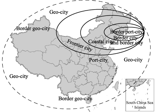
Figure 1 The scope of border geo-cities

2.3 Classification of border geo-cities in China and the surrounding countries

In this paper, geo-cities in China and the surrounding countries are regarded as a complete regional system. Considering the location differences of coast and land, together with the world geographical regionalization and geopolitical situation, the paper divides geo-cities into 2 basic types and 5 geographical regions. One type is coast bordering based on the classification standard of island line ownership, mainly referring to the South China Sea and the littoral states. The other is land bordering based on the real national boundaries, mainly referring to Northeast Asia, Southeast Asia, South Asia and Central Asia. The distribution of two types is different in geographical scope, but there exists intercross and close relationship. The five geographical regions are shown as follows (Figure 2). One is border geo-cities in Northeast. They consist of border cities in Northeast China, North China, the northern part of East China, Bohai and the Yellow Sea, along with border cities in Russia, Mongolia, North Korea, South Korea and Japan. The second is border geo-cities in Central Asia. They consist of border cities in Northwest China and Central Asian countries bordering China. The third is border geo-cities in South Asia. They consist of border cities in Southwest China and South Asian countries bordering China. The fourth is border geo-cities in Southeast Asia. They consist of border cities in Southern China, the southern part of East China, East China Sea, and border cities in Vietnam, Laos and Myanmar bordering China. The fifth is border geo-cities in the South China Sea. They consist of China’s border cities in Guangdong, Guangxi, Hainan, Hong Kong, Macao and Taiwan, and foreign border cities in Vietnam, Malaysia, Indonesia, Brunei and the Philippines, which play a vital role on the stability of the South China Sea. Five large regions involve 20 countries, 116 first-level administrative units, 5787 urban settlements, 522 border geo-cities, 5.8254 million square kilometers of land area in administrative jurisdiction, 103.9 thousand kilometers of highway mileage, and 35.5 thousand kilometers of railway mileage.
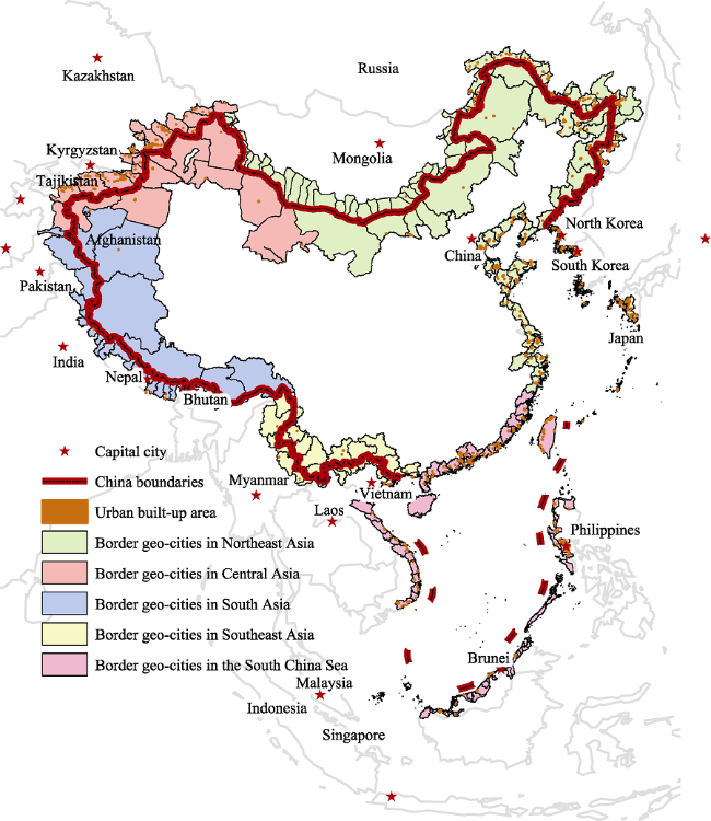
Figure 2 Classification of border geo-cities in China and the surrounding countries

3 Research ideas and method

Due to the characteristics of “location” and “connection” of border geo-cities, system structure and system functions which derive from space elements (point, line and polygon) and element combination, as well as the internal and external connection in border areas are always be affected. Thus, geo-setting of border geo-cities is revealed by statistical analysis of point, line and polygon. The number of border cities represents the current development status of border region urbanization in one country. The number of urban settlements represents the future development potential impacted by point feature. The number of provincial states indicates that the policy support or administrative restriction of border cities in future development. The mileage of railway and highway reflects the infrastructure construction of border geo-cities and urban security situation. Urban land areas are regarded as an important reference for the development potential of border cities impacted by polygon feature. Based on remote sensing image interpretation of land cover and spatial statistical analysis of geographic information system, this paper demonstrates the element analysis of border geo-cities in China and the surrounding countries (Table 2). Furthermore, this paper constructs the model of urban scale potentiality to analyze the overall regional differences of border geo-cities in a quantitative way.
Table 2 Element statistics of border geo-cities in China and the surrounding countries
Regions Countries Provincialstates Border cities Urban
settlements
Urban land area (km2) Highway
mileage
Railway
mileage
Northeast Asia China 10 48 2158 1555710.14 30039.91 17490.68
Russia 5 37 298 322755.24 4691.17 4241.65
Japan 2 4 134 23240.37 1791.35 1201.88
Korea 6 38 63 16705.77 1793.03 274.33
Mongolia 8 37 40 452869.90 3510.03 470.88
North Korea 9 55 79 31708.76 2235.00 956.50
The South
China Sea
China 6 24 1110 205469.00 13635.63 3108.09
Vietnam (sea) 18 87 137 32256.53 1304.27 1006.15
Philippines 4 15 279 56817.25 3697.40 589.99
Malaysia 2 37 93 52059.00 1915.24 98.94
Indonesia 2 2 15 8628.00 165.17 0.00
Brunei 3 12 7 1127.67 290.69 0.00
Central Asia China 2 9 142 876855.55 7766.06 2410.91
Kazakhstan 2 12 115 189182.34 3778.42 689.69
Kyrgyzstan 3 3 88 122089.65 3420.23 272.51
Tajikistan 1 1 10 37833.77 645.92 0.00
Russia 1 1 9 19165.95 1059.78 0.00
Southeast Asia China 2 13 359 271121.89 6375.70 1133.89
Vietnam (land) 7 33 59 27474.69 527.19 60.69
Laos 3 6 12 10958.98 347.12 0.00
Myanmar 2 9 138 142224.07 1675.27 231.85
South Asia China 2 7 166 1034593.45 7718.72 649.14
India 5 16 95 132565.24 2853.63 459.82
Nepal 5 10 106 109287.97 1465.29 107.12
Bhutan 4 11 5 13720.72 0.00 0.00
Afghanistan 1 1 3 11045.68 208.18 0.00
Pakistan 1 1 67 67909.30 1024.78 0.00
The calculation on regional differences of border geo-cities was done mainly by the importance model of geo-setting. The principles of model and measurement formula in detail are as follows. The important degree of border geo-cities and regions for a country in geo-setting structure is regarded as dependent variable, which is expressed by the weights of independent variable and reflects the influence and development potential of a country. Independent variables are the number of provincial states, border cities, urban settlements, urban land area, highway mileage, railway mileage, which are key influencing factors for the security and development of border geo-cities. What is more, some measures are taken to keep the objectivity and scientificity of independent variables. First of all, we clarify and classify the directions of variables. In this paper, the independent variables are divided into two classes. One is variable which means “the bigger the optimal”, such as the number of border cities, urban settlements, urban land area, highway mileage, railway mileage. The greater these variable values are, the larger development space and the more reasonable structure of border geo-cities are in the region. The other is variable which means “the smaller the better”, such as the provincial administrative unit. The number of provincial states is negatively correlated with urban development and expansion. The fewer the provincial states are, the better the regulation and management of border areas will be. Next, independent variable weights are set by using weight discriminated method of two-two indicators comparison. In virtue of professional knowledge and rational experience, we judge the comparative advantages and relative importance of two-two indicators. According to the comparative advantage, 5 types are set as absolute importance, very importance, comparative importance, slightly importance, and equal importance. The overall importance is greater for those indexes with more importance and comparative advantage. The greater the overall value is, the larger the final weight will be. The weight scores of independent variables are shown in Table 3.
Table 3 Weight scores of independent variables
Independent variables Provincial
states
Number of
border cities
Number of urban
settlements
Urban
land area
Highway
mileage
Railway
mileage
Weight scores 0.11 0.33 0.11 0.17 0.17 0.11
In addition, due to the non-unified units, these mining data and analysis need to be normalized. Given the indexes with different directions, we adopt different processing methods during data normalization. Normalization processing for the variables of “the bigger the optimal” is that each variable value subtracts the minimum value, and then divides the difference of maximum and minimum. Normalization processing for the variables of “the smaller the better” is that maximum value subtracts each value, and then divides the difference of maximum and minimum. The formulas are shown as follows respectively:
${a_{ijk}^{(s)}=\left[ u_{ijk}^{(s)}-u_{ijk}^{(\min )} \right]}/{\left[ u_{ijk}^{(\max )}-u_{ijk}^{(\min )} \right]}\;$ (1)
${a_{ijk}^{(s)}=\left[ u_{ijk}^{(\max )}-u_{ijk}^{(s)} \right]}/{\left[ u_{ijk}^{(\max )}-u_{ijk}^{(\min )} \right]}\;$ (2)
Ci = aij*awj (j=1, 2, 3,…, n) (3)
Ri = (C1+C2+…+Cn) / N (N=1, 2, 3,…, n) (4)
where uijk(s) represents the value of independent variable j of country i in a two-dimensional matrix k. uijk(min) represents the minimum value in matrix k. uijk(max) represents the maximum value in matrix k. aijk(s) represents normalized results. Ci represents the importance of country i in border geo-cities. aij refers to normalized difference index. awj refers to the weight value of independent variable j in the comprehensive evaluation. Ri refers to the important degree of border geo-cities of region i in China’s surrounding geo-setting.

4 Results and discussion

According to the above-mentioned research idea and method, the paper estimates the geo- setting of border geo-cities by using key elements statistics in China and the surrounding countries. The importance of borer geo-cities in spatial structure system is unveiled in Table 4.
Table 4 The importance of countries and regions in spatial structure system of borer geo-cities
Regions Region scores Countries Countries score Provincial states Border cities Urban settlements Urban land area Highway mileage Railway mileage
Northeast Asia 0.30 China 0.89 0.47 0.55 1.00 1.00 1.00 1.00
Russia 0.27 0.76 0.42 0.14 0.21 0.16 0.24
Japan 0.15 0.94 0.03 0.06 0.01 0.06 0.07
Korea 0.15 0.71 0.43 0.03 0.01 0.06 0.02
Mongolia 0.17 0.59 0.42 0.02 0.29 0.12 0.03
North Korea 0.16 0.53 0.63 0.04 0.02 0.07 0.05
The South
China Sea
0.19 China 0.40 0.71 0.27 0.51 0.13 0.45 0.18
Vietnam (sea) 0.15 0.00 1.00 0.06 0.02 0.04 0.06
Philippines 0.18 0.82 0.16 0.13 0.04 0.12 0.03
Malaysia 0.18 0.94 0.42 0.04 0.03 0.06 0.01
Indonesia 0.11 0.94 0.01 0.01 0.00 0.01 0.00
Brunei 0.11 0.88 0.13 0.00 0.00 0.01 0.00
Central Asia 0.16 China 0.27 0.94 0.09 0.06 0.56 0.26 0.14
Kazakhstan 0.18 0.94 0.13 0.05 0.12 0.13 0.04
Kyrgyzstan 0.14 0.88 0.02 0.04 0.08 0.11 0.02
Tajikistan 0.12 1.00 0.00 0.00 0.02 0.02 0.00
Russia 0.12 1.00 0.00 0.00 0.01 0.04 0.00
Southeast Asia 0.16 China 0.24 0.94 0.14 0.17 0.17 0.21 0.06
Vietnam (land) 0.13 0.65 0.37 0.03 0.02 0.02 0.00
Laos 0.11 0.88 0.06 0.00 0.01 0.01 0.00
Myanmar 0.16 0.94 0.09 0.06 0.09 0.06 0.01
South Asia 0.15 China 0.26 0.94 0.07 0.08 0.66 0.26 0.04
India 0.15 0.76 0.17 0.04 0.08 0.09 0.03
Nepal 0.13 0.76 0.10 0.05 0.07 0.05 0.01
Bhutan 0.11 0.82 0.12 0.00 0.01 0.00 0.00
Afghanistan 0.11 1.00 0.00 0.00 0.01 0.01 0.00
Pakistan 0.13 1.00 0.00 0.03 0.04 0.03 0.00
From the weight scores of variables and the importance in spatial structure system of border geo-cities, it can be seen that in terms of geopolitical security and regional development, the analysis in national dimension and in border cities dimension for the same geographical region produces rather different results. The priority of geo-setting security and development in China’s surrounding areas is Northeast Asia, the South China Sea, Central Asia, Southeast Asia and South Asia. The priority of security and economic development of China’s border cities are Northeast Asia, the South China Sea, Central Asia, South Asia and Southeast Asia. In general, as for the development environment of geo-cities in China’s border areas, the east is significantly better than the west, and the north is slightly better than the south. The differences of regional spatial structure about the security and development of border geo- cities are closely related to the strategic positioning, national status, comprehensive strength of large regions, neighboring countries and border cities.

4.1 Border geo-cities in Northeast Asia having better development conditions and obvious traffic advantages

Border geo-cities in Northeast Asia cover 40 provincial states, 2772 dispersed urban settle- ments, 2.403 million square kilometers of urban land areas, which account for more than 40% of the overall border geo-cities in China’s surrounding area (Table 4). In terms of the importance of regions in the spatial structure of geo-cities, Northeast Asian gains the highest score (0.30), and China in this region also obtains score as high as 0.89. Compared to other regions, border geo-cities in Northeast Asia have better development conditions and favorable environment.
The characteristics of border geo-cities in Northeast Asia are as follows. First, they have superior natural geographical environment. Except Inner Mongolia with plateau terrain, other areas in Northeast Asia are plains and hilly terrain. The Northeast China Plain, North China Plain and Yangtze Plain not only provide materials for the development of cities, but also save greatly transportation cost and communication cost. Besides, this region has humid climate, adequate water, convenient resource transportation, broad market demands, long history and colorful culture, good foundation for industrial development. All of these make Northeast Asia a preferred region for opening up and development of China’s border area. Second, this region has good open and development policies. In China, Northeast Asia region has the strategic policies of opening up and development of coastal area and border area. In the overseas, it has vast international markets such as Japan, Russia, South Korea, North Korea and Mongolia. All provide a perfect foundation for the full play of boundary effect. Third, this region has many border ports and cities. The distribution of border geo-cities in Northeast Asia is intensive. Many urban settlements are formed along rivers, bridges, highway and railway. In some areas with relatively favorable geographical conditions, many frontier ports come into being. Border cities and regional center cities not far from frontier ports also develop quickly and become the hinterlands. In addition, the corresponding relationships between ports and cities lay a good foundation for opening up and development of geo-cities in Northeast Asia. Fourth, this region has obviously comparative advantages of transportation. In the range of 2.403 million square kilometers of urban land areas in Northeast Asia, highway mileage reaches 44,060.49 kilometers, which accounts for 42% of the total mileage in China’s surrounding areas. Railway mileage is 24,635.92 kilometers, accounting for 69%. Both highway and railway mileage reach 68,696.41 kilometers, exceeding 50% of the overall land transport.

4.2 Geo-cities in the South China Sea having intensive spatial distribution and outstanding security issue

The South China Sea has broad waters, fewer lands and cities, while it involves many countries and regions. Although fewer land areas do border cities cover, the region includes many provincial states at home and abroad. Including six countries bordering the South China Sea with 3.5 million square kilometers of waters, this region involves 35 related second-level administrative units, 177 border cities and 1641 urban settlements, which account for 28% of the total border geo-cities in China’s surrounding areas. The regional score in the South China Sea is 0.19, next to Northeast Asia. China’s score is 0.4 in this region, significantly higher than other five countries.
The characteristics of border geo-cities in the South China Sea are as follows. First of all, the spatial distribution of geo-cities in South China Sea is intensive, and the size of urban settlements is large. From spatial patterns, it presents long and narrow stripes for the distributions of geo-cities in China, Philippines, Vietnam, Malaysia, Indonesia and Brunei, by which the South China Sea is surrounded. As for the distance from border cities to their political centers, other countries have shorter distance than China. With regard to the distribution of built-up areas of cities with a certain scale, Guangdong, Macao and Taiwan in China and Manila in the Philippines are more prominent in the South China Sea. The number of China’s urban settlements is the largest in this region. There are 1110 urban settlements within the range of 24 border cities in Guangdong, Fujian, Hainan, Hong Kong, Macao and Taiwan, which demonstrates that China’s southeast coast is densely populated in the surrounding geo-setting of the South China Sea. Second, aviation and pipeline are major transportations. Due to the restriction of sea waters, there are no highway and railway. Scattered airports, shipping routes and submarine pipelines are the predominant transportations. Third, the security of border geo-cities in the South China Sea is a striking problem. The territory and ownership of resources are still in dispute. This region is one of the most complex areas of international relations in China’s surrounding geo-setting. Countries neighboring the South China Sea having sovereignty disputes with China are the main bodies, which produce the conflict of the South China Sea and directly determine the security of border geo-cities. From the perspectives of geographical location, regional countries and interregional links, the geopolitical bodies of the South China Sea can be classified into three major types: intra-area counties, the intervening countries outside the area and associated international organizations (Hu H et al., 2012).

4.3 Geo-cities in Central Asia developing slowly and having significant value of strategic corridor

Central Asia is a region with vast territory but sparsely populated. Border cities encompass few provincial states ranging from 1 to 3. Jurisdiction of first-level administrative units for countries is relatively large. The number of border provinces, border cities and urban settlements is the least in Central Asia. Regional score of Central Asia is 0.16, and China’s score in this region is 0.27.
The characteristics of border geo-cities in Central Asia are as follows. Firstly, the spatial distribution of border geo-cities is sparse. The distribution of border cities or urban settlements is along the main traffic routes or assembled around scattered oasis or lakes. Secondly, air transportation is the primary way of traffic. Central Asia is located in inland with mostly mountainous plateaus. Highways and railways are fewer compared to other regions. Nevertheless, in some key nodes and important positions, there are traffic arteries or dual-use airports for the circulation of materials, persons and goods. In border areas of Central Asia, it is the regional characteristics of border geo-cities that using sparse air transportation and ports to maintain the security, stability and development of cities. The airport advantage in this region is far more than highway and railway. Thirdly, border geo-cities of Central Asia have great strategic significance for China. The development conditions in Central Asia are not desirable, which is drought and having many problems of transnational ethnic groups and terrorist activities. Yet it is a significant strategic corridor for China to connect West Asia and Europe. The comprehensive strength of Central Asian countries and their locations are always impacting the security and stability of border geo-cities in western China.

4.4 Geo-cities in Southeast Asia having complex administrative division and the vast potential for regional cooperation

The region of Southeast Asia involves 14 related provincial states, 61 border cities, 568 urban settlements above designated size, accounting for 12%, 12% and 10% of the total respectively. The regional score of Southeast Asia is nearly the same as that of Central Asia 0.16. China’s score in this region is 0.24.
The characteristics of border geo-cities in Southeast Asia are as follows. First, Vietnam is dominant in the number of border geo-cities. It has the largest number of border cities with 33 municipal level cities in 27,474.69 square kilometers of land area, which accounts for more than half of the total border cities. But the urban settlements are only 59. Second, administrative division is complex, and the standards are different. The size of administrative divisions in Myanmar is similar to that of China, yet the size of administrative divisions in Laos and Vietnam are much smaller and denser than that of southwest China. As for the built-up areas of cities, border geo-cities in Southeast Asia have fewer large-scale cities and built-up areas. Only in administrative center cities, can border cities with large scale built-up areas be observed, such as Kunming - the provincial capital of Yunnan, Hu Zhiming city - the capital of Vietnam. Third, the development of border geo-cities in this region is uneven. The development of border geo-cities in China is the highest owing to the combined effects of elements of point, line and polygon, for instance airports, highway ports, urban settlements, cross-border highways and rivers, built-up areas of cities and urban scale. The development of border geo-cities in Myanmar is the second to China. The lands bordering mileages between Myanmar and China in this region are the most. Although the number of border cities is small, the number of urban settlements is large. The development level of border geo-cities in Vietnam and Laos just reaches the half of China. Fourth, the development of port economy is comparatively mature. The region of Southeast Asia has a lot of border ports with 12 first-class ports and 8 second-class ports in China’s Yunnan Province. Port hinterland shaped by open border ports forms the invisible space and constantly expands, which become an important part of polygon element of spatial structure. It not only plays an essence role in southwestern China, but also plays an irreplaceable role in the international trade and logistics flow in the overall Southeast Asia.

4.5 Geo-cities in South Asia having obviously dense distribution and greatly developing difference

The region of South Asia covers 18 related provincial states, 46 border cities, 442 urban settlements, accounting for 16%, 9% and 8% of the total respectively. They are far fewer than those in Northeast Asia and the South China Sea. The regional score of South Asia is the lowest (0.15). China’s score in this region is 0.26, slightly higher than that in Southeast Asia.
The characteristics of border geo-cities in South Asia are as follows. Firstly, the dense distribution difference of border geo-cities is obvious. The distribution in China is sparse, while the distribution in India, Nepal and Pakistan is concentrated. In particular, there are more large-scale cities in Indian and Pakistani border areas. Secondly, the distribution of traffic lines is sparse. There are few highways and railways in geo-cities region along the national boundaries of India, Nepal, Bhutan, Afghanistan and Pakistan. There is only one highway linking Xinjiang and Tibet in China’s border. All indicate that the terrain of the Himalaya Mountains and geographical barrier indeed generates “barrier zone effect” to some extent. Plateau terrain, ice cover and harsh climatic conditions do produce many negative effects on the construction of traffic infrastructure. Thirdly, owing to the particularity of terrain, topography, climate and weather in border cities of South Asia, the construction of highway and railway as well as the development of urban settlements are slightly backward than those in other regions. The proportion of railway mileage in border geo-cities of South Asia is the smallest, only accounting for 3%. Among six countries, just three countries namely China, India and Nepal have a few railways in border cities. In South Asia, the development of infrastructure, industries and agriculture in China’s border geo-cities lags behind India, which is a distinguishing feature in South Asia compared to other regions.
In summary, we not only find the different distributed number, location characteristics in different border region in China and the surrounding countries, but also get some element statistics and the importance of countries and regions in spatial structure system of borer geo-cities. Based on the remote sensing information acquisition, the geo-statistical analysis in ArcGIS, we calculate the number of border cities, urban settlements, provincial states and the mileage of railway and highway which represents the current development status, the future potentiality, the policy support or administrative restriction, the infrastructure construction of border region urbanization and development. By setting dependent variable, independent variables, weight scores of independent variables, their relationship, computing formulas and adopt different processing methods during data normalization, we measure the important degree of border geo-cities and regions for a country in geo-setting structure. And the results of geo-setting evaluation of border geo-cities in China and surrounding countries well match the geo-politics of China’s surrounding international environment correspondence. Such as the Security Issue of the South China Sea, the Strategic Corridor and new Silk Road developments in Central Asia, the Traffic Advantages of China in Northeast Asia, the Potentiality for Regional Cooperation in Southeast Asia, the complex international relations in South Asia and so on. With the help of new technology and analysis method in the analysis of the geographical environment and the background of the international relations, we can get more cross-border information of urban spatial and regional development, thus there will be more quantitative evaluation and more scientific inference for the development of cities and the security of border regions in future.

5 Conclusions and future research

Based on the interdisciplinary perspectives of urban geography, regional economics and geopolitics, this paper explores the regional differences of border geo-cities in China and the surrounding countries by using the remote sensing information acquisition and ArcGIS spatial analysis. The main conclusions are drawn as follows.
(1) Based on world geographical regionalization and geopolitical situation in China’s surrounding area, and given the comprehension of sea-land coordination, along with domestic and international balance, border geo-cities in China and the surrounding countries are divided into five geographical regions: geo-cities in South China Sea, geo-cities in Southeast Asia, geo-cities in South Asia, geo-cities in Central Asia and geo-cities in Northeast Asia.
(2) The paper reveals the importance of regions and counties in spatial structure system through constructing the scale potential model of border geo-cities. According to the regional scores, the rank of priority of safety and economic development of China’s border geo-cities is geo-cities in Northeast Asia, geo-cities in South China Sea, geo-cities in Central Asia, geo-cities in Southeast Asia and geo-cities in South Asia.
(3) The characteristics of border geo-cities in China and the surrounding countries are as follows. Border geo-cities in Northeast Asia have good natural geographical conditions, obvious traffic advantages, dense urban settlements and many port cities. Geo-cities in the South China Sea develop maturely with the intensive distribution of coastal border cities and large-scale urban settlements. But the security issue of border areas is outstanding. Geo-cities in Central Asia have sparse distribution, few urban settlements, yet having the position of significant strategic corridor for China. Trades among countries are carried out through the ports connected by cross-border highways. Geo-cities in Southeast Asia have a lot of border ports, the complex administrative division, and the vast potential for regional cooperation. Geo-cities in South Asia have the different dense distribution, few traffic lines and less developed compared to other regions.
(4) The reasons for the regional differences of border geo-cities in China and the surrounding countries are analyzed. Location and connection lead to regional differences in border scales. The differences are gradually enlarged owing to the human segmentation and geographical barrier of settlements, national boundary, ridge line and valley line, river and lake. Meanwhile, the differences are steadily diminishing because of tangible and intangible connection with the bilateral trades, cross-border traffic lines, cross-border ethnic areas, entry and exit ports. Finally, the differences of regional distribution between core and periphery appear attributing to neighbor or not, connection frequency and interdependent coefficients. The development and changes of these differences produce new differences in urban scale, grade structure, development potentiality and functions of border geo-cities.
The future research on border geo-cities can be conducted in the following aspects: the influence factors and mechanism of regional differences of border geo-cities; the driving factors of border geo-cities development; the quantitative analysis of security and development for border geo-cities; the evaluation model of security and development; the comparative study of typical border cities; analysis on development orientation and regional orientation of border geo-cities. What is more, as the limitation of coverage, the accuracy of interpretation in terms of remote sensed/satellite images, field investigation, perhaps some involving local field work should be promoted to get more accurate Land Use/Land Cover data and deeper geographic information analysis.

The authors have declared that no competing interests exist.

[1]
Anishchenko A, Sergunin A, 2012. Twin cities: A new form of cross-border cooperation in the Baltic Sea Region?Baltic Region, 1(11): 27-38.

DOI

[2]
Buursink J, 2001. The bi-national reality of border-crossing cities.GeoJournal, 54: 7-19.In a time of changing border functions city pairs on either side of national state borders have increasingly become objects of attention, because of border crossing contacts and co-operation at the local level. This paper focuses on conceptual aspects of such city pairs, owing their existence to either duplication of an already existing city or to partitioning of a once united city. In search of a proper name that expresses the relations between such partner cities without metaphorical exaggeration, the current vocabulary is reviewed. Especially the notion of the ‘binational city’ receives critical attention. A discussion of selected cases of paired cities in Europe and North-America has been included to underline the importance of local conditions and historical backgrounds with regard to the mutual relations and conditions of co-operation. In conclusion the author states that for the time being ‘border–crossing’ cities seems to be the best name for city pairs of different national backgrounds, the emergence of true ‘binational cities’ being a rather exceptional outcome in a far future.

DOI

[3]
Champion A, 2001. A changing demographic regime and evolving polycentric urban regions: Consequences for the size, composition and distribution of city populations.Urban Studies, 38: 657-677.The demographic regime in western Europe and many other countries of the developed world is now very different from that of 30-40 years ago and is continuing to evolve. At the same time settlement systems have been altering significantly in spatial structure notably in terms of the emergence of polycentric urban configurations. This paper examines the nature of these two sets of changes and searches for linkages between them. First it outlines the main features of the changing demographic regime. Secondly it attempts to identify what constitutes polycentric urban regionsas opposed to traditional monocentric structures. Thirdly it assesses how recent demographic developments relate to traditional urban structures and discusses whether they are more conformable with polycentric urban forms.

DOI

[4]
Cherpitel C J, Ye Y, Bond Jet al., 2015. Border effects on DSM-5 alcohol use disorders on both sides of the U.S.-Mexico border.Drug & Alcohol Dependence, 148(3): 172-179.Little epidemiological evidence exists on alcohol use and related problems along the U.S.–Mexico border, although the borderlands have been the focus of recent media attention related to the escalating drug/violence “epidemic”. In the present study, the relationship of proximity of living at the border and alcohol use disorders (AUDs) is analyzed from the U.S.–Mexico Study on Alcohol and Related Conditions (UMSARC). Household surveys were conducted on 2336 Mexican Americans in Texas (771 in a non-border city and 1565 from three border cities located in the three poorest counties in the U.S.) and 2460 Mexicans from the states of Nuevo Leon and Tamaulipas in Mexico (811 in a non-border city and 1649 from three cities which are sister cities to the Texas border sites). Among current drinkers, prevalence of AUD was marginally greater (p<0.10) at the U.S. border compared to the non-border, but the opposite was true in Mexico (p<0.001), and these trends continued on both sides across volume and 5+ drinking days. Prevalence was greater in Laredo/Nuevo Laredo relative to their respective sister city counterparts on the same side. Border effects appeared greater for males than females in the U.S. and the opposite in Mexico. The data suggest that border proximity may affect AUD in both the U.S. and Mexico, but in the opposite direction, and may be related to the relative perceived or actual stress of living in the respective communities.

DOI PMID

[5]
Dürrschmidt J, 2006. So near yet so far-blocked networks, global links and multiple exclusion in the German-Polish borderlands.Global Networks, (3): 245-263.Abstract Abstract The building blocks of global society are conventionally thought of in terms of ‘flows’, ‘scapes’, ‘key nodes’, and ‘global cities’, to name a few. We rarely consider borders and border regions. However, state borders provide a crucial component of a globalizing society in transition. Exhibiting a structural ambivalence, borders can be seedbeds of cosmopolitanism, sites of cultural closure, or often both simultaneously. To understand cross-border interaction we have to engage with a complex configuration of global and sub-global dynamics. In this article I argue that borders are revealing analytical tools that must be included in any grounded theory of global change. I draw on fieldwork conducted in the German-Polish border region, mostly in the German-Polish twin city Guben/Gubin. Here we are confronted with the simultaneous processes of globalization, European integration and post-socialist transformation.

DOI

[6]
Ehlers N, Buursink J, Boekema F, 2001. Bi-national cities and their regions: From diverging cases to a common research agenda.GeoJournal, 54: 1-5No Abstract available for this article.

DOI

[7]
Eskelinen H, Kotilainen J, 2004. Imatra-Svetogorsk: Kaupunkiparista kaksoiskaupungiksi.Idäntutkimus, 1: 28-35.

[8]
Fang Xiaoping, Li Peng, Ding Sibao, 2011.The gradient structure and the echelon development value of the value of the border area: A case of the border area along China and the ASEAN countries.Economic Geography, 31(9): 1409-1413. (in Chinese)In the context of economic globalization and regional economic integration growing much stronger day by day,the research and practice of the location value of the border area has an important meaning and application prospect.The article interpretes the meaning about the location value of the border area,constructes the model of the location value of the border area with the principal component analysis method,demonstrates the gradient structure of the location value of the border area,and researches the echelon development pattern.The paper does empirical research as the border area along China and the Asian countries as an example.

[9]
Fanni Z, Khakpour B A, Heydari A, 2014. Evaluating the regional development of border cities by TOPSIS model: Case study Sistan and Baluchistan Province, Iran.Sustainable Cities and Society, 10: 80-86.The intensity of centralization and imbalance are the characteristics of polar growth policy in the developing countries. According to the necessity of integrated regional development, analyzing the dependence of human's settlement in the border regions are the foundation issue in every planning. The optimal distribution of population, social and economic development process is the ultimate goal of regional systems. Such as reducing deprivation and inequality and their political and economic consequences is both important and considerable issue. In addition, achieving pervasive progress and development involves recognizing the specific situation in each region. In order to, the applied methodology is based on qualitative and quantitative methods with point on social indicators to adjusting the level of settlements in the spatial system of the regions and reduction and removal of the existing inequalities among these regions. Results showed that in 2009 Zahedan county ranked 1 and Konarak county ranked 10th among 10 counties of Sistan and Baluchistan (the distribution coefficient was 6%), including a sharp difference and the intensity of the inequalities in obtaining the benefits of development. Therefore, the dominant paradigm over the spatial structure of Sistan and Baluchistan follows the central-peripheral paradigm.

DOI

[10]
Gu Lin, 2010. Research on cross-border economic cooperation in inland border of frontier area: Take Suifenhe city of Heilongjiang province as example [D]. Changchun, China: Jilin University. (in Chinese)

[11]
Guo Rongxing, 2012. US-Mexico border environment cooperation.Developments in Environmental Science, (10): 279-305.

[12]
Guo Wenjun, 2009. Research on Yanbian economic development strategy in Tumen River regional cooperation [D]. Yanbian, China: Yanbian University. (in Chinese)

[13]
Hanson G H, 2001. US-Mexico integration and regional economies: Evidence from border-city pairs.Journal of Urban Economics, 50(2): 259-287.In this paper, I examine U.S.–Mexico border-city pairs to see whether integration between the United States and Mexico is contributing to the expansion of economic activity in the border region. To the extent transport costs are the main nontrade policy barriers to trade, we expect regional integration to cause economic activity in border cities to expand. The question I ask is whether the growth of export manufacturing in Mexican border cities increases the demand for goods and services produced in neighboring U.S. border cities. I estimate demand links between Mexican and U.S. border cities using data on the 10 major border-city pairs over the period 1975–1997. The results indicate that the growth of export manufacturing in Mexico can account for a substantial portion of employment growth in U.S. border cities over the sample period.

DOI

[14]
Heyman J M, 2001. Class and classification at the US-Mexico border.Human Organization, 60(2): 128-140.U.S. immigration and nationality law is viewed as a set of classifications that contribute to the...

DOI

[15]
Hu Hao, Ge Yuejing, Hu Zhiding, 2012. The geopolitical environment of greater neighborhood of the South China Sea.World Regional Studies, 21(3): 36-44. (in Chinese)The Nansha islands,Xisha islands and other islands in the South China Sea have always been one part of China's territory,but now there are a great number of disputes in this area,making it one of the hot spots in the world.What is more,the political,military,economic and geopolitical environment surrounding of the South China Sea region has become more and more complex.In this article,the formation of the South China Sea issue is discussed from the perspective of geopolitical environment analysis.The result shows that the South China Sea issue is a complex problem which related to multiple-layered interests,including intra-area countries,the intervening countries outside the area,and associated international organizations.Stability Maintenance of the South China Sea will inevitably depend on the consideration of the geopolitical environment of greater neighborhood of this region.

[16]
Hu Zhiding, Luo Huasong, Li Cansonget al., 2012. Triple functions of country border and its concerning optimized combination under the perspective of geopolitical security.Human Geography, 27(3): 73-77. (in Chinese)Borders,and especially international borders,have long been a prominent theme in political geography.On the one hand,borders between states demarcate the territory and jurisdiction of states;on the other,there is talk of the disappearance of borders,at the very least,their declining significance in an era of globalization.In the past 20 years,Sub-regional cooperative research has experienced three changes in research direction: the first is the research of the sub-regional Economic Cooperation;The second is the research of non-economic effects of the sub-regional economic cooperation;The third is the research of non-economic factors and non-economic areas of collaboration of the sub-regional cooperation.Meanwhile,the non-traditional border security is emerging apparently.The above three aspects have a close relationship with each other,and can change into each other under certain conditions.The triple function of national borders and their interactions and they can be transformed into each other determines that it process national bounder more complicated.On the basis of analyzing the relationship among the three aspects,we have put forward such optimized ideas as trapezoidal strategic mode,rational and quantitative evaluation,and establishment of the multi-main body and multi-level coordinated institutions to optimize the combination of the country border.

[17]
Javed S, 2014. Role of socio cultural factors in depression among elderly of twin cities (Rawalpindi and Islamabad) of Pakistan. Current Gerontology and Geriatrics Research, 1-5. .

[18]
Johnson C M, 2009. Cross-border regions and territorial restructuring in central Europe: Room for more trans- boundary space.European Urban and Regional Studies, 16(2): 177-191.

DOI

[19]
Kosonen R, Loikkanen K, 2005. Twin cities or paired border cities? Three case studies from the Finnish border. Paper presented at the Inaugural Nordic Geographers Conference, May, 11-13, Lund University, Sweden.react-text: 342 This article demonstrates how the nature of the post-socialist transition shapes the institutional business environment over time, and how this shows in foreign firms' strategies. We analyze this question through Finnish business operations in two post-socialist countries, Russia and Estonia, drawing on 169 semi-structured interviews. We show how a rapid and goal-oriented transition quickly... /react-text react-text: 343 /react-text [Show full abstract]

[20]
Krätke S, 1999. Regional Integration or fragmentation? The German-Polish border region in a new Europe.Regional Studies, 33(7): 631-641.KR02TKE S. (1999) Regional integration or fragmentation? The German-Polish border region in a new Europe, Reg. Studies 33 , 631-641. This paper deals with the problems of regional economic integration in the German-Polish border area, focusing on the nature and intensity of cross-border inter-firm linkages. It firstly emphasizes the differentiation of regional development paths in East Central Europe, contrasting a 'high road' and a 'low road' to development. Then the problems of cross-border regional integration are discussed with regard to exogenous and endogenous influences. Exogenous influences on the development of the border region include the investment strategies of western firms in former East Germany and Poland. Endogenous influences include communication barriers and a 'low trust environment' which is rooted in the particular development history of this region. These factors help to explain why only weak and qualitatively 'low level' approaches to economic co-operation between regional firms on both sides of the border have emerged. KR02TKE S. (1999) Intégration régionale ou morcellement?: la région frontalière entre l'Allemagne et la Polognè a l'heure européenne, Reg. Studies 33 , 631-641. Cet article cherchè a aborder la question de l'intégration économique, régionale dans la zone frontalière entre l'Allemagne et la Pologne, portant sur les caractéristiques et l'importance des maillons interentreprises, transfrontaliers. Dans un premier temps, on souligne la différenciation entre les sentiers de croissance régionale dans l'est de l'Europe centrale, tout en comparant un 'sentier haut' à un 'sentier bas'. Dans un deuxième temps, on discute de la question de l'intégration régionale transfrontalière quant aux influences exogènes et endogènes. Les influences exogènes sont, parmi d'autres, les stratégies d'investissement des entreprises occidentales situées dans l'ex Allemagne de l'Est et la Pologne. Les influences endogènes comprennent les barrières à la communication et un 'milieu à faible investissement' lequel remontè a l'histoire particulière du développement de cette région. Ces facteurs aident à expliquer pourquoi il s'est fait jour des fa04ons faibles et qualitativement 'de bas niveau' d'aborder la coopération économique entre les entreprises situées des deux c00tés de la frontière. KRA¨TKE S. (1999) Regionale Integration oder Zersplitterung? Das deutsch-polnische Grenzgebiet in einem neuen Europa, Reg. Studies 33 , 631‐641. Dieser Aufsatz befa08t sich mit den Problemen regionaler wirtschaftlicher Integration im deutsch-polnischen Grenzgebiet, wobei Natur und Intensit01t grenzüberschreitend miteinander verknüpfter Firmen in den Blickpunkt gerückt werden. Er betont zun01chst die Unterschiede regionaler Entwicklungswege in Ostmitteleuropa, bei denen sich Wegge zur Entwicklung ‘von oben' und ‘von unten' gegenüberstehen. Dem folgt eine Diskussion der grenzüberschreitenden regionalen Integration im Hinblick auf exogene und endogene Einflüsse. Zu den exogenen Einflüssen auf die Entwicklung des Grenzgebiets geh02ren die Entwicklungsstrategien westlicher Firmen im ehemaligen Ostdeutschland und Polen, zu den endogenen die Kommunikationsschranken und ein ‘Milieu geringen Vertrauens', das seine Wurzeln in der besonderen Entwicklungsgeschichte der Region hat. Diese Faktoren tragen dazu bei, zu erkl01ren, warum nur schwache, oder verh01ltnism0108ig bescheidene Ans01tze zu wirtschaftlicher Zusammenarbeit zwischen Firmen beiderseits der Grenze gemacht wurden.

DOI

[21]
Laura M N, Mark F, Phillip G, 2009. Forecasting urban growth across the United States-Mexico border.Computers, Environment and Urban Systems, (33): 150-159.We analyzed the cross-border watershed using regression analysis from satellite images from 1975, 1983, 1996, and 2002 and created urban area classifications. We used these classifications as input to the urban growth model, SLEUTH, to simulate likely patterns of development and define projected conversion probabilities. Model results indicate that the two cities are undergoing very different patterns of change and identify locations of expected growth based on historical development. Growth in Nogales, Arizona is stagnant while the urban area in Nogales, Sonora is exploding. This paper demonstrates an application that portrays how future binational urban growth could develop and affect the environment. This research also provides locations of potential growth for use in city planning.

DOI

[22]
Li Huijuan, 2010. The development model of Chinese frontier port cities [D]. Beijing, China: Central Minzu University. (in Chinese)

[23]
Lunden T, Zalamans D, 2001. Local cooperation, ethnic diversity and state territoriality: The case of Haparanda and Tornio on the Sweden-Finland border.GeoJournal, 54: 33-42.The neighbouring towns of Haparanda and Tornio, separated only by a narrow strip of grass and wetland, are divided by the only inhabited land boundary between Finland and Sweden in the southern part of the Torne River. The population represents four different groups in relation to linguistic and cultural backgrounds. In the daily lives of the inhabitants, the state boundary is probably of less significance than linguistic, social and ‘ethnic’ differences. On the local government level there is a strong will to unite forces to make the total area a viable region in spite of its peripheral location, but state legislation makes co-ordination difficult. This may be seen as a necessity, but in the daily lives of the populations, the state boundary defines an area of unequal access, sometimes working in favour of and sometimes barring contacts and co-operation. The media consumption reflects a clear ‘national’ interest with a strong local bias. In their attitudes, Finnish speakers and bilinguals show a greater appreciation of ‘the other’ than unilingual Swedes. This may reflect the actual possibility space ( reach ) in the local area.

DOI

[24]
Ma Bo, 2011. Study on regional economic integration in China’s border area [D]. Beijing, China: Central Minzu University. (in Chinese)

[25]
Marcelli E A, Cornelius W A, 2001. The changing profile of Mexican migrants to the United States: New evidence from California and Mexico.Lat. Am. Res. Rev., 36: 105-131.Using recent data from southern California and Mexico, we challenge the notion that the demographic profile of Mexican migrants to the United States since 1970 has remained constant. We find that more recent cohorts of migrants are more likely to settle permanently in the United States, to have higher proportions of females, to be younger, to have more education, to be increasingly likely to originate in southern Mexico and the Mexico City metropolitan area, and to be increasingly likely to depart from urban areas within Mexico. Although we find no direct evidence that the legalization programs mandated by the Immigration Reform and Control Act of 1986 has led to a stronger propensity to settle permanently in the United States, logistic regression analyses demonstrate the importance of the other three main explanatory factors suggested by Wayne Cornelius in 1992: economic crisis in Mexico, the changing character of U.S. demand for labor, and social networks.

DOI

[26]
Markus P, 2005. The construction of new scales: A framework and case study of the Euregio cross-border region. CSGR Working Paper, No.165/05.

[27]
Meijers E, Hoogerbrugge M, Hollander K, 2014. Twin cities in the process of metro-polisation.Urban Research & Practice, 7(1): 35-55.

[28]
Mikhailova E V, 2013. Appearance and appliance of the twin-cities concept on the Russian-China’s border. ISPRS: International Archives of the Photogrammetry, Remote Sensing and Spatial Information Sciences, XL-4/W3: 105-110.The article is devoted to the city pair of Blagoveshchensk (Russia) and Heihe (People's Republic of China), the only city pair in Russian-Chinese borderland that describes itself with the term "twin-cities". The current contribution reconstructs the history of appearance of the twin-cities concept in Russian-Chinese agenda. On the basis of interviews and questionnaires collected in the cities in question the paper examines specificity of understanding of "twin-cities" concept and its practical execution in the Asian context. Exploring the extent to which the twin-cities relations model is applicable to Russian-Chinese border cities, the author concludes that cooperation predominantly exists in a form of bilateral annual events in various spheres (culture, education, sport, etc.) and dialog between delegations of region's/city's representatives, not in a form of direct people-to-people or institution-to-institution cooperation. The lack of local initiatives to cooperate (almost zero-amount of initiatives not from region's/city's administrations) is named as a main drawback of Blagoveshchensk and Heihe relations. While planned character of cooperation makes the calendar of joint events stable and predictable, it also keeps Russian-Chinese cooperation staying on the ritual level and prevents it to become a necessary part of everyday life.

DOI

[29]
Miguel G C, Cuauhtémoc S R, Sharada Vet al., 2014. Supply chain dynamics and the “cross-border effect”: The U.S.-Mexican border’s case.Computers & Industrial Engineering, 72: 261-273.A system dynamics model is proposed for analyzing the uncertainty caused by delays and disruptions at the U.S.–Mexican border, and how their effects propagate through the cross-border supply chains. Since Mexico’s geographic proximity and low wages provide logistics advantages to North American Free Trade Agreement (NAFTA), it is becoming a favored manufacturing and logistics location. Nonetheless, crossing the border between U.S. and Mexico remains one of the most important challenges to the NAFTA supply chain competitiveness. Based on literature review and real-life information, the security policies at the U.S.–Mexican border and their cost implications to cross-border supply chains are identified. Information regarding the impact of variability on supply chain dynamics due to “ cross-border effect ” derived of security inspection policies is provided. Results are based on an auto-industry case study that was chosen due to its process standardization; however, results could be applied to other global supply chains. As conclusions, implications for the design of cross-border supply chains are exposed and future research is presented.

DOI

[30]
Odile H, 2001. The bi-national cities of Dover and Calais and their region.GeoJournal, 54(1): 61-71.This paper analyses the question of cities that are localised at each part of an international border. We take as an example the two cities of Dover and Calais and look at if they can be considered as binational cities, because they have been recently connected by a tunnel, the ‘fixed link’, and because since 1993, the inner state borders of the European Union have disappeared. It determines firstly if these two towns have been brought closer by the construction of the Channel tunnel and if specific ties are linking these two towns. The article scrutinizes actions taken under INTERREG funds under the general framework of the creation of the ‘Transmanche Region’ and its extension towards a Euroregion to sort out these two cities joint involvement. Finally, it checks if this new area could lead to cross-border activity either for work or tourism and leisure purposes that could conduct the cities of Dover and Calais toward a new type of relationship, premises of a binational city.

DOI

[31]
Ramos R, Ferreira-Pinto J O B, Brouwer K Cet al., 2009. A tale of two cities: Social and environmental influences shaping risk factors and protective behaviors in two Mexico-US border cities.Health & Place, 15(4): 999-1005.Abstract The economic, social, cultural, and political milieus that influence HIV risk behaviors along the US-Mexico border are understudied. In an effort to appropriately inform interventions targeting structural influences, we compared injecting drug using populations living in two cities--Ciudad Ju rez, Chihuahua and Tijuana, Baja California--situated on the Mexico-US border. These populations presented with similar demographic profiles, but differed significantly in terms of social and environmental influences that can influence both risk and protective factors (e.g., family drug use, migration, drug use patterns). We observed distinct behavioral and structural influences in these two border cities that will require tailored intervention strategies to reduce HIV transmission.

DOI PMID

[32]
Riitta K, Xu F, Erja K, 2008. Paired border towns or twin cities from Finland and China.Chinese Journal of Population, Resources and Environment, 6(1): 3-13.This paper discusses cross-border cooperation at the level of urban socio-economic systems.Worldwide,cross-border urban cooperation has in several cases produced socio-economic and political coherence supported by various joint programs and efforts.However,the degree of coherence varies and seldom creates socio-economically and politically tightly integrated "TwinCities" where the state border becomes highly transparent or obscure.Focusing on Finland and China,our aim is to identify whether the selected border towns represent coherent TwinCities or a more loose type of "paired border towns".The study uses an empirical examination of three Finnish towns (Helsinki,Tomio,Imatra) and their neighboring towns in Estonia,Sweden,and Russia as a benchmark.Then,a comparative study is made regarding three Chinese eross-border cities facing Russia,Vietnam and Kazakhstan.We highlight the differences in cross-border integration from the viewpoint of shared public sector programs,cross-border enterprise relocation and networking,and integrated social sector in terms of labor market,education and shopping area.

DOI

[33]
Shi C, Fernando H J, Yang J, 2009. Contributors to ozone episodes in three US/Mexico border twin-cities.Science of the Total Environment, 407(18): 5128-5138.The Process Analysis tools of the Community Multiscale Air Quality (CMAQ) modeling system together with back-trajectory analysis were used to assess potential contributors to ozone episodes that occurred during June 1-4, 2006, in three populated U.S.-Mexico border twin cities: San Diego/Tijuana, Imperial/Mexicali and El Paso/Ciudad Ju rez. Validation of CMAQ output against surface ozone measurements indicates that the predictions are acceptable with regard to commonly recommended statistical standards and comparable to other reported studies. The mean normalized bias test (MNBT) and mean normalized gross error (MNGE) for hourly ozone fall well within the US EPA suggested range of +/-15% and 35%, respectively, except MNBT for El Paso. The MNBTs for maximum 8-h average ozone are larger than those for hourly ozone, but all the simulated maximum 8-h average ozone are within a factor of 2 of those measured in all three regions. The process and back-trajectory analyses indicate that the main sources of daytime ground-level ozone are the local photochemical production and regional transport. By integrating the effects of each process over the depth of the daytime planetary boundary layer (PBL), it is found that in the San Diego area (SD), chemistry and vertical advection contributed about 36%/48% and 64%/52% for June 2 and 3, respectively. This confirms the previous finding that high-altitude regional transport followed by fumigation contributes significantly to ozone in SD. The back-trajectory analysis shows that this ozone was mostly transported from the coastal area of southern California. For the episodes in Imperial Valley and El Paso, respectively, ozone was transported from the coastal areas of southern California and Mexico and from northern Texas and Oklahoma.

DOI PMID

[34]
Simon M, Grant M, 2004. Cross-border post-secondary education in the Asia-Pacific region. In: Internationalization and Trade in Higher Education: Opportunities and Challenges. Oraganisation for Economic Co-operation and Development Publishing, 137-204.Several single-center studies have confirmed the usability of cerebrospinal fluid (CSF) biomarkers for the diagnosis of Alzheimer's disease (AD), even in early disease stages. Large scale multicenter studies have principally confirmed this, although such studies have also indicated the presence of significant intercenter and interlaboratory variations in biomarker measurements. Such variations may hamper the development of biomarkers and their introduction into clinical routine practice. Recently a quality control program run by the Alzheimer's Association was started in order to harmonize procedures of laboratories world-wide. This program provides both standardized guide lines and external control CSF samples, and will allow longitudinal evaluation of laboratory performance.

DOI

[35]
Song Yang, Wang Shijun, 2006. Study on the transnational integrative development of geo-cities.Areal Research and Development, 25(1): 62-66. (in Chinese)Combining with the tendency of economic globalization, regional economic integration and urban integration,this paper is based on the theories and concepts of "geo",and puts forward the concept of "geo-city". By defining border,subregional cooperation and urban integration,it clarifies the basic intension of the transnational integration of geo-cities,and summarizes general characters,dynamic mechanism as well as basic models of transnational integration of geo-cities.Geo-city is a city that undertakes certain task in the geo-area.The transnational integration of geo-cities is one kind in the type of urban integration,which mainly refers to the course of the geo-city's interaction and integration with the opposite geo-city cross the border.

[36]
Wu Haojun, 2011. The strategies of cross-border twin-city integration: A comparative analysis between San Diego-Tijuana twin-city and Hong Kong-Shenzhen twin-city.Urban Planning International, 26(4): 69-73. (in Chinese)The paper tries to interpret the integration goals and actions by analyzing the differences between San Diego-Tijuana Twin-City and Hong Kong-Shenzhen Twin-City from four core elements,including cooperated fields,land use nearby cross-border expresses,cross-border travel,cross-border ports.Three practical strategies for the integration of Hong Kong-Shenzhen Twin-City are suggested at the end of the paper.

[37]
Wu Y A, 2012. Study of conditions for the success of international exchange and cooperation in cross-border cities networks: The case of ‘Busan-Fukuoka cross-border Megaregion’ in Northeast Asia.The Korean Journal of Local Government Studies, 16(3): 31-50.

[38]
Wu Bing, Wang Yafeng, Tong Yukai, 2012. Study on the interaction mechanism between the border ports and cities in the hinterland.Urban Development Studies, 19(9): 32-38. (in Chinese)According to the classification of the first-level port cities along the border in China,the interaction mechanism between the border ports and cities in the hinterland is revealed on the basis of the economy competitiveness index of the border ports with the analysis on SPSS11.5 software.The results show that the port economy is the fundamental element in driving the integration of the coast cities and improving the growth of interactive space in the economic geography unit.At present,the port economic factors have more significant role in the full development of the county-level cities of the border ports and less influence on the development of border ports of the prefecture-level city.It is essential for port economic and geographical unit to accelerate the polarized growth of the type of industry to achieve the interaction mechanism between the border ports and cities in the hinterland.

[39]
Yan Xiaopei, Leng Yong, 1997. Study on the coordinative development of Shenzhen-Hong Kong twin cities.Acta Geographica Sinica, 52(Suppl.1): 95-103. (in Chinese)This paper focuses on the coordinative development of Shenzhen-Hong Kong twin cities. The attention is initially paid to the conditions of the emergence of the twin cities. The analysis results have showed that the historical and geographical factors, reform and open-door policies, and the influences of economic globalization are main conditions. Then the socio-economic links between the twin cities are analysed. There exist close social and economic links between them, mainly including the flows of capital, goods, persons and information. The capital flow is mainly comprised by the investment from Hong Kong. From 1979 to 1995 ,the investment from Hong Kong accounted for 79. 2% in Shenzhen' s total received foreign investment. The good flow in-cludes that through and between the twin cities. Hong Kong has been the largest import and export market of Shenzhen. Since the reform,Shenzhen' s import from Hong Kong have beenmainly containing raw and processed materials, and fittings, which are needed by the joint-ven-tures in Shenzhen. And the products of these joint-ventures comprise a large share of Shenzhen' s export. With the development of the social and economic links,the flows of person and information become more and more strong. The infrastructures like transportation and communication between the Shenzhen and Hong Kong are further linking up and become the necessary channels of the flows between the twin cities.Thirdly. the urban spatial expansion of Shenzhen and Hong Kong is examined. Because of the close links of the twin cities, the main economic activities and urban land use of Shenzhen have showed a border-oriented tendency, namely developing along the belt bordering Hong Kong. On the contrary,Hong Kong' s urban spatial expansion mainly occurs in the south of the city, and the development of the north part has been ignored for a long time,which has resulted in the formation of non-blended economic space of the twin cities.Fourthly, the challenges and problems of the twin city development are identified. It seems that the twin cities face the challenges of external conditions,such as the prevalence of interna-tional trade protectionism, the gradual disappear of policy advantages which Shenzhen obtained at the begining of the reform,and the competitions from other countries. In addition,there have appeared some problems; 1 )the government of twin cities are lack of contacts; 2)the economic cooperations still stay at the low level; and 3)the link-up of infrastructures is not satisfactory.Finally, the suggestions and perspectives about the twin city development are put forward : DTo strengthen the cooperation, especially between the city governments. 2) To change the pattern of economic cooperation. 3)To make the economic space of the twin cities blend. It is believed that with the regain of Hong Kong revereignty in 1997,Shenzhen-Hong Kong twin cities will be further invoved the economic globalization and play an increasing important role in the world urban system.

[40]
Zhang Jun, Li Lan, 2002. The border city development of western China under the background of western development.Journal of Guangxi University (Philosophy and Social Science), 24(2): 48-52. (in Chinese)

[41]
Zhou Yixing, Zhang Li, 2001. The foreign-oriented hinterland of Chinese port-cities.Scientia Geographica Sinica, 21(6): 481-487. (in Chinese)Port-city is the hinge that links open China and the world economy. Foreign economic relations havebecome one important part of Chinese economic life since the reform and opening. Along with China's successentrance to WTO(World Trade Organization), the economic contacts with foreign countries wi1l become closerand closer, therefor, it's necessary to study port-city's hinterland from foreign economic linkage angle. Foreigntrade is one of the main forms of Chinese foreign economic relations and the 39 cities with customs at office levelin 1997 can be seen as the main port-cities of China. On the basis of the foreign trade goods flow data between39 port-cities and 324 inland trade districts in l997, this paper tries to revel the spatial pattern of foreign eco-nomic linkage of Chinese mainland through the study of port-cities' foreign-oriented hinterland.At first, the paper compares the port-cities' foreign trade goods volumes that represent the dominance ofport-cities in foreign trade linkages, and finds the port-cities in different areas possess different significances inforeign goods flow. The port-cities in china's eastern coastal areas are the main pivots that link china with for-eign countries, there were more than 95 percent foreign trade flow passed through the coastal port-cities inl997. In the eastern coastal areas, the port-cities' dominances in foreign trade flow are different too, the firstthree port-cities, Shanghai, GuangZhou, and Shenzhen comprise 54 percent of the total foreign goods flow.Tianjin, Qingdao, Dalian and Nanjing are also important port-cities in the coastal areas. The regional disparityin foreign trade development and seaport status is the main factors affecting the port-cities' dominance.Then the study of port-cities' hinterland in foreign trade linkages also indicates the coastal port-cities' sig-nificance. Not only the coastal areas is under their control, but most backland foreign goods flow also has to passthrough the coastal port-cities. The port-cities that are located 6 coastal city-and-town concentrated areas, thePearl River Delta Region, the Yangtze River Delta Region, the Beijing-Tianjin- Tangshan Region, the Centraland Southern Liaonng Province, Shandong Peninsular and the Southeastern Fujian Province, are the main pas-sages to the outside, their influence sphere neariy covers all the country.The distribution of coastal port-cities' foreign-oriented hinterland takes on evident regional character, andshows the feature of interweaving too. To reflect the macroscopical spatial pattern of port-cities' hinter1and, thecoastal port-cities are organized into six port-city groups, including the Pearl River Delta Region, the YangtzeRiver Delta Region, the Beijing - Tianjin - Tangshan - Qinhuangdaao Region, the Central and Southern Lia-onng Province, Shandong Peninsular, and the Coastal Fujian port-city group. Further study shows that the sixport-city groups have more evident regional division in foreign trade linkages. According to the port-city groups'foreign-oriented hinterland, Chinese mainland was divided into 4 large foreign economic linkage regions whichnamed the North-East Region, the Ye1low River Basin Region, the Yangtze River Basin Region and the SouthChina Region, 2 more little regions(Shandong and Fujian Region) and several bordering regions whose mainforeign economic partners are bordering countries.

[42]
Zhu Yuanyuan, Wang Shijun, Feng Zhangxian, 2011. The central place system structure and formation mechanism research of the Chinese northeastern border area center.Economic Geography, 31(5): 724-729. (in Chinese)By constructing the border region center central indicator system and Using the factor analysis method,this paper extracts local fiscal revenue,actual use building,import and export trade,foreign trade dependency,urbanization rate and port number and level 6 principal componentes of the 38 cities in northeastern border county to measure their centralities.They have been delimited three ranks.The paper determines that the spatial pattern of the northeastern border areas presents five level 1,eight secondary,Twenty-five level 3 central places.Five level 1 central places include Suifenhe,Manzhouli,Dandong,Hunchun and Heihe.Also on the basis,the paper analies the spatial pattern and the formation mechanism of centre system characteristics in northeast border area.

Outlines

/