Research Articles

Spatial evolution of coal transportation at coastal ports in China

  • WANG Wei , 1, 2, 3, * ,
  • WANG Chengjin , 1 ,
  • JIN Fengjun 1
Expand
  • 1. Institute of Geographic Sciences and Natural Resources Research, CAS, Beijing 100101, China
  • 2. University of Chinese Academy of Sciences, Beijing 100049, China
  • 3. School of Geography, Beijing Normal University, Beijing 100875, China

Author: Wang Wei, PhD, specialized in transport geography and regional development studies. E-mail:

*Corresponding author: Wang Chengjin, Professor, specialized in economic geography and transport geography. E-mail:

Received date: 2016-11-22

  Accepted date: 2017-01-11

  Online published: 2018-02-10

Supported by

National Natural Science Foundation of China, No.41571113, No.41771134, No.41701126

Strategic Priority Research Program of CAS: Evaluation of Connectivity of Infrastructure Network and Spatial Optimization

Copyright

Journal of Geographical Sciences, All Rights Reserved

Abstract

Coal is a basic resource and its use guarantees the development of national economies and human society. Thus, coal transportation is an important part of China’s overall transportation system. In this system, ports are the vital transit nodes. This study considered coastal ports in China and analysed the evolution of coal transportation from 1973 to 2013. We focused on the spatial pattern of coal loading and unloading, and summarized the main characteristics and development of the processes. Then, we examined the volumes of coal transported and regional changes in these amounts using mathematical models and indicators. Finally, we analysed the specialized function and spatial differentiation of the ports involved in coal transportation to reveal their spatial relationship and temporal evolution. We found that the spatial pattern of coal transportation changed from “south input and north output” to “all input and north output”. However, the prominent ports used for coal unloading are still concentrated in areas south of the Yangtze River. Coal loading is concentrated on the west bank of Bohai Bay. In addition, some ports around Bohai Bay, such as Dandong, Dalian, Yantai, and Qingdao, changed from traditional coal loading ports to unloading ports. This study further developed the theory of transport geography, and improved our understanding of China’s coal transportation system.

Cite this article

WANG Wei , WANG Chengjin , JIN Fengjun . Spatial evolution of coal transportation at coastal ports in China[J]. Journal of Geographical Sciences, 2018 , 28(2) : 238 -256 . DOI: 10.1007/s11442-018-1470-4

1 Introduction

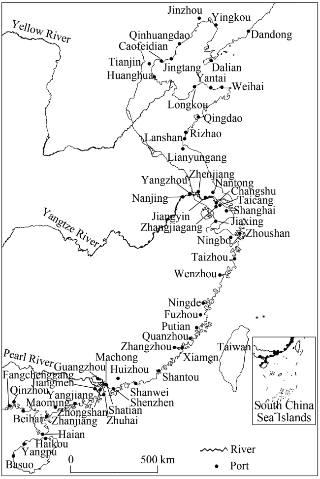
Coal is the main energy resource in China and is an important industrial material. It provides about 70% of the country’s energy and more than 60% of the raw materials used by industry. In the next ten years, the heavy chemical industry will continue to grow and the consumption of coal will also expand. The country’s coal-dominated energy consumption structure cannot be changed for quite a long time. Therefore, consideration should be given to the supply and transportation network of coal resources (Cai and Zhang, 2006). Many studies have been conducted worldwide on coal transportation and supply. Some have compared the cost of different transportation modes to determine the optimum systems, such as identifying the best ways to transport coal from west to east in Canada (Ash and Waters, 1991), and comparing the cost of coal transportation in the American West Highlands by slurry pipeline and railway (Kania, 1984). The relationship between coal transportation and the geographical environment is an interesting research field. Socio-economic systems and topography are important factors that can affect coal transportation; in particular, the spatial structure of existing transport networks directly determines the pattern of allocation of coal resources (Elmes, 1984). Mathematical models have been used to depict coal flows from the coal supply base to the consumption base. Some studies have analysed the coal flow in America (Leblanc et al., 1978). Many studies have also considered the global coal logistics network (Zaklan et al., 2012). Research in different countries has had a different emphasis because of the different spatial relationship between coal distribution and socio-economic systems. China is rich in coal resources, but also has a huge demand for coal consumption. Coal production and transport are of great significance to China’s social and economic development (Todd, 1997). Previous studies have considered the spatial and temporal coordination of the national energy supply (Zhang et al., 2012), investigated the spatial and temporal pattern and undertaken a potential evaluation of the development of China’s energy resources (Ma et al., 2010), and analysed China’s coal supply and future output (Wang et al., 2013). These studies have evaluated the developmental pattern of coal resources in China. The spatial mismatch between the coal supply base and the consumption market has prompted many researchers to consider interregional allocation and the transporting of coal resources (Yu et al., 2006). Some studies of the spatial and temporal variation of the coal satisfaction rate, self-sufficiency rate, and external satisfaction rate have been conducted (
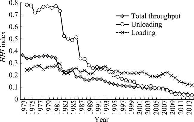
Ma and Jin, 2014). Many studies have considered the evolution of the spatial flow pattern of coal resources and the factors that have influenced its development in China (Zhao and Yu, 2007; Cheng et al., 2008; Wang et al., 2009; Che et al., 2014; Wang and Zhao, 2014). The development of transport corridors and their routes are also important issues that have been investigated. Researchers have systematically analysed the current situation and development of the coal trade and its transport corridors in China (Wang and Ducruet, 2014), with a focus on the optimization of the distribution of the corridors (Wei, 2008; Liu et al., 2013) and the railway network (Ji and Zhao, 2014; Jiang et al., 2013). There have been few studies of coal transportation at ports. Existing studies have mainly focused on two aspects. One is the forecasting of coal throughput at ports (
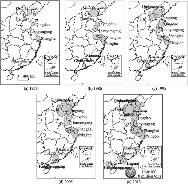
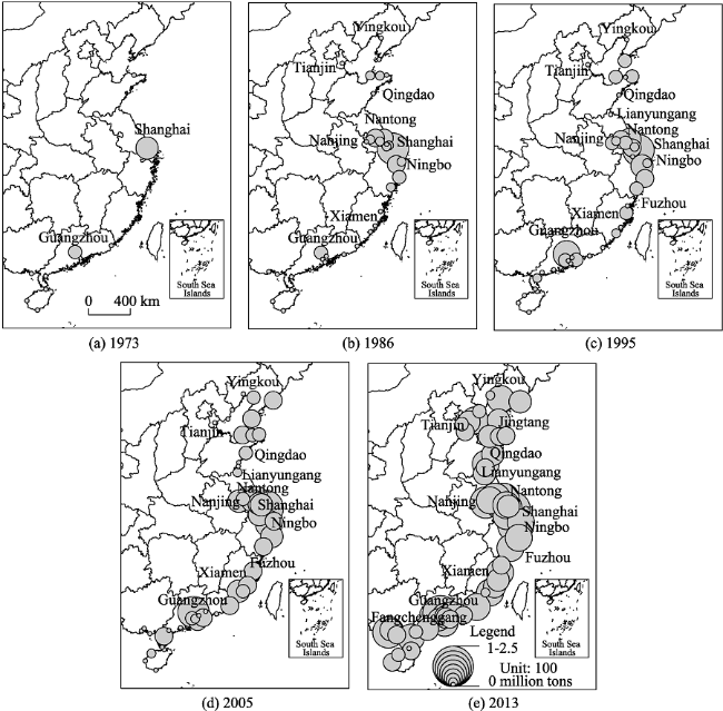
Liu et al., 2014), while the other is research regarding specific ports or areas; for example, studies of the current situation with regard to coal transportation in the ports of Qinhuangdao and Tianjin (Yang, 2011; Yu, 2012), investigating the logistical coal capacity of ports in Tianjin and Hebei Province (Dong and Wang, 2012), and considering the evolution and dynamic mechanisms of coal transportation for the ports around Bohai (Wang and Wang, 2014).
In summary, previous studies have mainly focused on the pattern of coal exploitation, the interregional allocation, and transportation by the rail network. Few studies have focused on coal transportation through ports, especially on the spatial pattern and evolution of coal transportation of China’s coastal ports using long-term data. Therefore, this study considered the characteristics and evolution of coal transportation at China’s coastal ports using data collected since the 1970s. The aim was to identify and summarize any spatial patterns, investigate the relationship between loading and unloading, and to obtain a better understanding of China’s coal transportation system.

2 Data and methods

2.1 Data and samples

This study used coal transportation data for China’s coastal ports and some related economic indicators. The coal transportation data was coal throughput, and loading and unloading volumes, while the economic indicators were mainly performance data for high coal consumption industries, which reflect the demand for coal. The coal transportation data for China’s coastal ports were obtained from the Yearbook of China Transportation and Communications, published by China’s Ministry of Transport. A small number of data were obtained from port portals. Related economic data were taken from the China Statistical Yearbook. The study considered the period from 1973 to 2013. As the focus of the study, we selected coastal ports in China, of which there are 57 according to the National Plan for Coastal Port Layout (Figure 1). In the Yangtze River Delta, we followed the traditional definition, in which ports below Nanjing are considered to be ocean ports.
Figure 1 Coastal ports in China

2.2 Evaluation model

National coal transportation at ports is a complex spatial system involving many different ports. Each port has different levels of dominance and throughput. Furthermore, there is not only coal loading, but also coal unloading occurring at individual ports, which can reflect the relationship between regional development and the supply and demand of coal. To examine the complexity of coal transportation and reveal the characteristics of spatial variation, we measured indexes based on three aspects: the spatial agglomeration level of port coal transportation, intensity of specialized function, and the relationship between loading and unloading in the same port.
Agglomeration is an important spatial concept in geography. It can reflect the spatial non-equilibrium of resources and economic activities. An agglomeration analysis of coal transportation is beneficial to the study of spatial structure and can identify the characteristics of spatial variation of coal transportation system. It can also reveal the status and function of different ports in the coal transportation and national economic network. The Herfindahl-Hirschman Index (HHI) is an effective method used to measure spatial agglomeration; thus, we used it to evaluate the spatial agglomeration of coal transportation. The formula used in the calculation is as follows:
$H{{H}_{i}}=\sum\limits_{i=1}^{n}{{{({{X}_{i}}/T)}^{2}}}$ (1)
where Xi is the coal throughput or the volume of coal loaded and unloaded at port i, and T is the total throughput or the volume of coal loaded and unloaded at all coastal ports. The range of HHi is [0, 1]. The closer to zero the value is, the lower the level of spatial agglomeration is.
The HHi index can only evaluate the macro-spatial structure of port coal transportation. It cannot be used to determine the status and hierarchy of each port in the whole system. A location quotient is required. The cargo location quotient is the ratio of the proportion of a certain type of cargo in a single port to its proportion among all coastal ports in the country. It can reflect the level of specialization of the port toward coal transportation and the standard of the terminal facilities. The formula used in the calculation is as follows:
${{Q}_{ij}}=\frac{{{t}_{ij}}/{{t}_{i}}}{{{T}_{j}}/T}=\frac{{{{t}_{ij}}}/{\sum\nolimits_{j=1}^{n}{{{t}_{ij}}}}\;}{{\sum\nolimits_{i=1}^{m}{{{t}_{ij}}}}/{\sum\limits_{i=1}^{m}{\sum\limits_{j=1}^{n}{{{t}_{ij}}}}}\;}$ (2)
where Qij is the location quotient of cargo j for port i, tij is the throughput of cargo j for port i, ti is the throughput of port i, Tj is the throughput of cargo j for all coastal ports, and T is the total throughput of all coastal ports. If Qij ≤1, then port i does not have specialized functions in the transportation of this cargo. If Qij >1, cargo j is the specialized cargo for port i, and the larger the value is, the stronger the specialized functions of the port are.
Although the location quotient of coal can be used to investigate the transportation advantages of an individual port, it cannot be used to determine the relationship between coal loading and unloading at the same port. This relationship reflects different aspects of regional development and the supply and demand of coal. Thus, we constructed the Ri index to evaluate the relationship between the loading and unloading of coal. The formula used in the calculation is as follows:
${{R}_{i}}={{{T}_{ije}}}/{{{T}_{ij}}}\;={{{T}_{ije}}}/{({{T}_{ije}}}\;+{{T}_{ijf}})$ (3)
where Tije is the volume of coal loaded at port i, and Tijf is the volume of coal unloaded at port i. The range of Ri is [0, 1]. The closer to 1 the value is, the higher the level of coal loaded at the port is.

3 Spatial evolution of coal loading and unloading at China’s coastal ports

The transportation of any goods involves both an origin and a destination. Most of the coal throughput at China’s ports is domestic. Coal loading and unloading takes place at different ports in China. The different coal loading and unloading ports reflect the spatial relationship between ports, the coal supply base, coal consumption market, and shipping routes. An investigation of the spatial pattern and evolution of coal loading and unloading ports can help us to understand the pattern and mechanism of coal transportation in China.

3.1 Spatial pattern and evolution of coal loading

Port coal loading refers to the transportation of coal to ports by road and then the outward shipping of the coal. A port is not only the starting point of the coal shipping process, but is also the gateway of land transportation of coal. The location, throughput, and spatial agglomeration level of coal loading ports can reflect the relationship between ports, the coal supply base, and transportation corridors. In this study, we systematically established the volume of coal loaded at China’s coastal ports (see Figure 2).
Figure 2 Spatial pattern and evolution of coal loading at coastal ports in China, 1973-2013
Since the 1970s, the pattern of coal loading at China’s coastal ports has roughly evolved in four stages. Each stage had a different number of ports, area served by ports, loading scale, and level of activity as a proportion of national port activity. In the first stage, in the early 1970s, there were only 11 coal loading ports: Qinhuangdao, Shanghai, Qingdao, Lianyungang, Dalian, Guangzhou, Yantai, Zhanjiang, Tianjin, Shantou, and Yingkou. The scale of coal loading was very small at only 14.47 million tons in 1973. Qinhuangdao and Shanghai loaded larger volumes of 5.04 and 4.07 million tons, respectively. A “north output” pattern of coal loading ports began to appear. During the second stage, in the mid-1980s, the number of coal loading ports gradually increased, especially in the Yangtze River Delta. There were 29 ports in this period. The volume of coal loaded was 75.74 million tons in 1986. Qinhuangdao loaded the largest volume of coal in China at 31.50 million tons, which represented 42% of the national total. In Shanghai 13.50 million tons were loaded, and the difference in the volume loaded between Qinhuangdao and Shanghai continued to increase. There was a high degree of spatial agglomeration and the loading volume was concentrated on the west bank of Bohai Bay, the south of Shandong Peninsula, and the Yangtze River Delta. A “north output” pattern officially formed, which resulted from the output of the three western districts of the three provinces region (Shanxi, Shaanxi, and Inner Mongolia Autonomous Region). Since the beginning of the third stage in the 1990s, the number of coal loading ports increased rapidly. There were 39 ports in 1995, in which a total volume of 152 million tons of coal was loaded. At 12 ports, more than one million tons of coal was loaded. Qinhuangdao handled the largest volume of 64.88 million tons, accounting for 42.7% of the national total. The volume handled at Tianjin, Rizhao, and Shanghai was more than 10 million tons. This was closely related to the rising volume of coal exported, which accounted for more than 25% of the loading volume in these ports. The volume of coal loaded continued to increase on the west bank of Bohai Bay and the south of Shandong Peninsula, while at the Yangtze River Delta the volume remained relatively stable. The coal output function of northern ports continued to strengthen. In the fourth stage, since the 21st century, the volume of coal loaded increased at a faster rate. It was 414 million tons in 2005 and 914 million tons in 2013. Coal exports decreased rapidly during this period due to the tightening of the resource export policy and the implementation of an energy security strategy. Therefore, growth in the coal loading volume was mainly due to the rapid increase in domestic trade. The number of ports was 49, with 34 where the volume of coal loaded was more than one million tons. Qinhuangdao was still the largest coal loading port in China, handling around 40% of the national total, but there was a downward trend in later years, with the figure decreasing to 25.8% in 2013. The volume of coal loaded at Huanghua port increased to 130 million tons, accounting for 14.5% of the national total. Tianjin, Jingtang, and Caofeidian each accounted for 9%. The five ports with the largest volumes of coal loaded in 2013 were located on the west bank of Bohai Bay, and together accounted for 67.3% of the national total. Therefore, the “north output” pattern of coal loading did not change and continues to develop on the west bank of Bohai Bay. The agglomeration level of the Yangtze River Delta and south of Shandong Peninsula increased. The volume of coal loaded in the ports in the Pearl River Delta also increased. There was a rapid increase in the volume of coal loaded in the Beibu Gulf ports, especially in Fangchenggang where the volume increased from 0.64 million tons in 2005 to 11.63 million tons in 2013. The enhancement of the coal loading function of ports in the Pearl River Delta and the Beibu Gulf was mainly due to the secondary distribution of imported coal.

3.2 Spatial pattern and evolution of coal unloading

Port coal unloading refers to the transport of coal from other ports. In this system, a port is the landing gateway to the onward transportation of coal to various regions. The distribution and scale of coal unloading ports reflects not only coal transportation routes, but also the location and scale of the coal consumption market. In this study, we systematically established the volume of coal unloaded at China’s coastal ports (see Figure 3).
Figure 3 Spatial pattern and evolution of coal unloading at coastal ports in China, 1973-2013
We can determine the following characteristics from Figure 3. (1) Scattered and isolated southern ports were initially involved in coal unloading, but it gradually began to occur at all coastal ports; i.e., a move from a “south input” pattern to an “all input” pattern. The number of coal unloading ports continued to expand, and unloading coal became the transportation function of most ports. This is consistent with the growth trend of China's coal imports, and also reflects that coal brought in through ports was widely used as an energy supply in coastal areas. Due to the rapid increase in the number of coal unloading ports over time, the total volume of coal unloaded grew rapidly, but the difference in the scale at each port was relatively small. (2) In the early 1970s, there were only nine coal unloading ports: Shanghai, Guangzhou, Zhanjiang, Shantou, Haikou, Basuo, Beihai, Yantai, and Sanya. These ports were mainly distributed in southern China and a “south input” pattern began to appear. The volume of coal unloaded was small, at only 12.89 million tons. Shanghai had the largest volume, accounting for 88.3% of the national total. (3) In the middle of the 1980s, the number of ports was 35. They were concentrated in the Yangtze River and southern regions, especially in the Yangtze and Pearl river deltas. There was a small increase in the number of northern ports where coal was unloaded. The volume of coal unloaded increased to 56.73 million tons. Shanghai accounted for 57% of the national total, while the other ports made quite small contributions. During this period, China’s coal imports were small and grew slowly. The “south input” pattern of coal unloading was strengthened. This was because there were few coal resources in the southeast coastal area of China, but its developed economy and dense population consumed large amounts of electric power. The importation of coal from other regions was the main energy supply mode for this area. (4) The volume of coal unloaded continued to increase. It reached 110 million tons in 1995, and the number of coal unloading ports increased to 41. There were 16 ports where the volume of coal unloaded was more than one million tons. Shanghai was the largest, accounting for 38% of the national total. In terms of the spatial pattern, coal unloading was concentrated in the Yangtze River Delta, followed by the Pearl River Delta, the Shandong Peninsula, and the Liaodong Peninsula. An “all input” pattern began to appear. (5) Since the middle of the 1990s, the demand for coal increased due to rapid economic growth. Domestic trade and the import of coal experienced strong and rapid growth. China’s coal imports exceeded 200 million tons in 2012 and 300 million tons in 2013. In 2011, China surpassed Japan to become the world's largest coal importer. There was explosive growth in the volume of coal unloaded in coastal ports since the new century, with the volume exceeding 200 million tons in 2004, 300 million tons in 2005, 400 million tons in 2007, and 900 million tons in 2013. The number of coal unloading ports was 57. All of the large and medium sized ports in the country began to unload coal. The volume of coal unloaded in the northern ports grew rapidly. In addition to the Yangtze River Delta and southeast Fujian, the volume of coal unloaded in the Beibu Gulf and the Pearl River Delta also increased. The “south input” pattern became an “all input” pattern. There were 32 ports where the volume of coal unloaded exceeded 10 million tons in 2013. Shanghai was still the largest port, accounting for 8.8% of the national total, although this represented a large decline compared with the early period. At Ningbo and Guangzhou, more than 50 million tons of coal were unloaded, accounting for 7.5% and 5.5% of the national total, respectively. A comparison of 2013 and 2005 revealed a trend for rapid expansion in the volume of coal unloaded at ports around Bohai Bay. These ports became not only coal loading ports, but also unloading ports. At this point, the “all input” pattern of coal unloading of China’s coastal ports was completed.

4 Spatial agglomeration of coal transportation at China’s coastal ports

4.1 The evolution of spatial agglomeration at all coastal ports

As a special type of bulk cargo, the transportation of coal cannot be evenly distributed. With the construction of new ports and the improvement of transportation routes, as well as yield changes in the coal base, the coal transportation functions of each port displayed different growth trends. The trend toward the spatial agglomeration of coal transportation reflects the role of different ports in coal transportation and the national economic network. It can be used to examine the relationship between ports and regional development. As shown in Figure 4, the HHI index values for coal throughput, and the volume loaded and unloaded displayed a significant downward trend during 1973 to 2013. The level of spatial agglomeration of coal transportation decreased. More explicitly, the three curves of the HHI index shown in Figure 4 decreased rapidly and significantly before the end of the 1980s, while afterwards, they showed a steady downward trend and a smaller decline. This indicates that coal throughput, and the volume loaded and unloaded were eventually distributed among many different ports, and the phenomenon of concentrating activity in a few ports gradually weakened. The changes in the early part of this period were due to the increase in the number of ports, while the changes in the late period were due to changes in the volume of coal handled at each port. The HHI index value for coal loading was lower than that for throughput and unloading before the 1980s, but thereafter it was higher than that of throughput, and after the 1990s it was higher than the value for unloading. This indicates that the level of spatial agglomeration for coal loading was higher. The phenomenon of concentrating activity at a few ports was more prominent. This is consistent with the analysis above.
Figure 4 Herfindahl-Hirschman Index (HHI) index values for total throughput, and the loading and unloading of coal at coastal ports in China, 1973-2013
(1) Coal throughput: The coal throughput of China’s coastal ports was higher in the 1970s than later in the study period, with an HHI index value of about 0.35. It started to fall after the 1980s and reached 0.171 in 1990. It then displayed a steady and slow decline, reaching 0.046 in 2013.
(2) Volume of coal loaded: The HHI index value for the volume of coal loaded declined steadily throughout the study period. It was 0.244 in 1973 and 0.118 in 2013. Sudden increases in individual years were related to the expansion of the coal loading capacity in Qinhuangdao port. In particular, the “north output” pattern resulted in the HHI index curve being higher than the other two curves.
(3) Volume of coal unloaded: The HHI index value for the volume of coal unloaded displayed a similar trend, but the decline was more obvious. It was very high in the 1970s, with a value of 0.785 in 1973. In 1988, it declined to 0.28. Thereafter it declined slowly and reached 0.036 in 2013. This was mainly due to the rapid expansion of coal unloaded from a few ports in the early part of the study period to most ports later in the study period. In other words, it was because coal unloading at coastal ports changed from a “south input” to an “all input” pattern.

4.2 The evolution of spatial agglomeration at regional ports

The hinterland of each port has different natural and socio-economic properties. These differences, especially the industrial structure and distribution of coal resources, have important influences on the functioning of coal transportation and its developmental trend. It can also affect the overall characteristics and functional differences of regional ports. Although each group of regional ports considered in this study had the function of coal transportation, there were some differences in the functions of coal loading and unloading. This reflects the diverse relationship between regional development and coal supply and demand. As shown in Figure 5, there were significant differences in terms of the volume of coal loaded at each group of regional ports. Ports on the west bank of Bohai Bay have maintained an absolute dominant position in coal loading. Qinhuangdao, Huanghua, Jingtang, and Tianjin are all loading ports. And most of them are specialized coal ports. The proportion of coal loading continued to increase throughout the study period. It was 35.2% in 1973 and 75.5% in 2007. In recent years, an expansion in the coal transport capacity occurred due to the Daqin, Shuohuang, and Houyue railways. The Houyue railway provides a direct line to customers, while Daqin and Shuohuang railways, corresponding to the ports at Qinhuangdao and Huanghua, respectively, are main lines that can accommodate materials arriving by ocean shipping. Therefore, the status of ports on the west bank of Bohai Bay has become more significant in the coal loading system. The Yangtze River Delta was an important coal loading area in the early 1970s. The proportion of national coal loading undertaken here was 41.1% in 1978, but thereafter it continually decreased, reaching 11.6% in 2007. Shandong Peninsula was another important coal loading area whose contribution to the national total also declined. It was 20.3% in 1973 and 2.8% in 2013. The volume of coal loaded in the Pearl River Delta, Beibu Gulf, southeast Fujian, and Liaodong Peninsula was small and stable, always being less than 5% of the national total.
Figure 5 Proportion of all port groups involved in coal loading and unloading in China, 1973-2013
Unloading coal is a transportation function for most ports. Most of the coal unloading activity is concentrated in the Yangtze and Pearl River Delta. These two regions are not only the frontiers of China’s reform and opening up program, but are also the country’s new industrial bases. A large proportion of China’s population, economic output, and urban spaces are concentrated here, while in comparison other regions have maintained low levels. For many years, the Yangtze River Delta was the main region of the country to where coal was transported. The region was responsible for a large proportion of the national coal unloading, but its importance in this regard has continued to decline. In 1973 it accounted for 88.2% of the national coal unloading, but this had declined to 52.5% by 2013. The Pearl River Delta is another important region of coal consumption, where the proportion of the national coal unloading increased at first and then decreased. It was 9.8% in 1973, 30.7% in 2002, and 18.8% in 2013. The volume of coal unloading in southeast Fujian was small, but its proportion of the national total has steadily increased from 1% in 1986 to 7.8% in 2013. Shandong and Liaodong peninsulas are important regions for coal loading, but their ports also have unloading functions. The proportion of the national coal unloading undertaken in these ports has fluctuated significantly, but with an increasing trend. They both increased from 0.3% to about 5% in 2013, which was mainly due to coal imports. As an area with few coal resources, the proportion of the national coal unloading undertaken at Beibu Gulf increased before the end of the 1970s. It reached 2.1% in 1977, and then decreased to 0.3% in 2002. After a period of rapid growth, it reached 6.8% in 2013. The west bank of Bohai Bay is the main area of coal loading in China. The proportion of the national coal unloading undertaken in the region was tiny prior to the turn of the new century, but has increased significantly in recent years and reached 3.9% in 2013. This growth is mainly due to the unloading of imported coal. The enhancement of the coal unloading function of northern ports has begun to gradually change the traditional functional pattern of ports in terms of coal transportation.

5 Functional differentiation of coal transportation at China’s coastal ports

5.1 Functional differentiation of coal transportation

A port is a traffic node for loading and unloading, storage, and transportation of a variety of goods. Coal transportation is only one of the functions of a port. The intensity of this function reflects the level of specialization of the port toward coal transportation and the standard of the terminal facilities, which has a great effect on port facilities and the spatial structure of land use. We calculated the location quotient of each port according to the volume of coal loading and unloading and the results are shown in Figures 6 and 7.
Figure 6 Spatial pattern and evolution of the location quotients of coal loading at coastal ports in China
Figure 7 Spatial pattern and evolution of the location quotients of coal unloading at coastal ports in China
The location quotient of coal loading reflects the intensity of each port in the function of outputting coal. There were four ports with a location quotient larger than 1 in 1973: Qinhuangdao, Lianyungang, Qingdao, and Shanghai. Qinhuangdao and Lianyungang had location quotients of 3.2 and 2.2, respectively, which indicates that they had significantly advantageous locations for coal loading. There were a few scattered ports with a location quotient less than 1. In 1986, 1995, and 2005, the number of ports with a location quotient larger than 1 was eight. The location quotient for Qinhuangdao and Rizhao was always larger than 2, and these ports maintained a dominant position in coal loading. In the mid-1980s, there was an obvious differentiation in coal loading between the north and the south. Ports with a location quotient lower than 1 were mainly distributed south of the Yangtze River. The “north output” pattern was obvious. Thereafter, some specialized coal ports (e.g., Jingtang and Huanghua) emerged, and became the main coal loading ports in addition to Qinhuangdao and Rizhao. In 1995, the advantages of coal loading in the Yangtze River Delta weakened, while they were strengthened for a small number of ports in south China. The spatial mode of loading in the northern ports did not change. The spatial pattern of 2005 was strengthened compared with 1986. The advantages of Bohai Bay for coal loading were strengthened, while the area south of the Yangtze River Delta was weakened. The spatial differentiation of coal loading became more prominent over the study period. In 2013, ports whose location quotient was larger than 1 and smaller than 1 were distributed in intervals. There were 12 ports with a location quotient larger than 1, accounting for 1/5 of all ports. The area served by these ports expanded, and some ports in southeast Fujian and Beibu Gulf had obvious advantages in coal loading. Ports whose location quotient was lower than 1 were mainly distributed in the west of Liaoning Province, Shandong Peninsula, the south of Zhejiang Province, the south of Fujian Province, and the east of Guangdong Province. The ports of Huanghua, Qinhuangdao, and Machong had the most prominent coal loading function, with a location quotient larger than 3. Huanghua is a specialized coal port and mainly transports coal from Shenfu coalfield. Coal accounts for 98% of the loading volume in Huanghua. Qinhuangdao is the world’s largest coal loading port and mainly transports coal from the Datong Coal Mining Group. Its volume of coal loading was 240 million tons in 2013, accounting for 30% of the national total. The location quotients of Putian, Jingtang, Caofeidian, Yangzhou, and Jiaxing were between 2 and 3, while the values for Jiangyin, Fangchenggang, Tianjin, and Jinzhou were larger than 1. On the north coast, the prominent coal loading ports were distributed in a cluster, while some individual coal loading ports such as Putian and Machong were located on the south coast. Although the volume of coal loaded at these two ports was small, it represented a large proportion of the total material loaded at the ports. The spatial pattern changed from a “north-south differentiation” to a “space interval” mode. Ports on the north coast have group advantages, while the southern coastal ports have individual advantages.
The location quotient of coal unloading ports reflects the inputting function of each port. Basuo, Shanghai, Guangzhou, and Sanya had values larger than 1 in 1973 and were all located south of the Yangtze River. The number of prominent coal unloading ports increased to 14 in 1986. The unloading function of ports in the Yangtze River Delta, northern coastal ports, and ports in Hainan Province was strengthened. Ports whose location quotients were lower than one were mainly distributed in Liaodong Peninsula, the west bank of Bohai Sea, south of Shandong Peninsula, southeast of Fujian, the Pearl River Delta, and Beibu Gulf. In 1995, there were 19 ports with a location quotient larger than 1. Among them, Taizhou and Yangjiang were larger than 3 and their coal unloading advantages were obvious. Ports with quotients larger than 2 were mainly located in the Yangtze River Delta, the Pearl River Delta, and Shandong Peninsula. Ports with a location quotient less than 1 were mainly distributed in the Liaodong Peninsula, the west bank of Bohai Bay, Shandong Peninsula, northern Jiangsu, southeast Fujian, and eastern Guangdong. In 2005, the number of ports whose location quotients were larger than 1 further increased to 25. Among them, Basuo was larger than 4, while Zhangzhou, Jiaxing, and Sanya were larger than 3. The coal unloading advantages in southeast Fujian became apparent. The Yangtze River and the region to the south formed a continuous area where coal unloading was dominant. In 2013, all coastal ports had a coal unloading function, but for most of them there were only minor advantages over other activities, and therefore they were not specialized coal unloading ports. The number of ports with a location quotient larger than 1 was 33. Taiping, Basuo, Shanwei, and Machong had quotients greater than 4, and had the largest capacity for coal unloading. Taiping and Machong are small ports in the Pearl River Delta, each with a well-developed coal unloading function, but only small quantities of coal are unloaded. They mainly supply coal to nearby power plants. Coal unloaded at Shanwei is also mainly supplied to local power plants. Ports whose location quotients were less than 1 gradually emerged in the area around Bohai Bay. Jingtang, Weihai, Longkou, and other Bohai Sea ports all had location quotients less than 1. Tianjin, Qingdao, Jinzhou, Lanshan, Dalian, and Caofeidian did not have any advantages for coal unloading, because their location quotients were less than 0.3. The unloading advantages of ports around Bohai and south of the Shandong Peninsula were strengthened, but their location quotients were still lower than 1. From the above analysis, it was found that although the unloading pattern of coastal ports changed from a “south input” to “all input”, ports with an obvious unloading advantage were still concentrated south of the Yangtze River.

5.2 Relationship between coal loading and unloading at coastal ports

The location quotient is a macroscopic judgment of the advantages of coal transportation, but it cannot identify the relationship between coal inputs and outputs, which determine a port’s status in the coal transportation system. If we only consider the proportion of coal loading undertaken at each port, they can be broadly divided into loading ports, unloading ports, and comprehensive ports (Table 1). Based on experience, we classified ports with an Ri larger than 0.6 as coal loading ports, ports with an Ri less than 0.4 as coal unloading ports, and ports with an Ri between 0.4 and 0.6 as comprehensive ports. Using this classification, there are only six coal loading ports in the coastal areas of China, accounting for about 1/10 of the ports considered in this study. Five ports are comprehensive ports, accounting for about 1/12 of the total studied, and 46 ports are coal unloading ports, accounting for 4/5 of the total studied. This structure confirms that coal loading is mainly concentrated in a small number of ports, most of which are coal unloading ports, which is consistent with the above analysis.
Table 1 Classification of coastal ports in China according to their coal loading and unloading activity
Category Proportion of loading (%) Name of port Number
Coal loading
ports
90-100 Qinhuangdao, Tianjin, Huanghua, Jinzhou, Caofeidian 5
60-90 Jingtang 1
Comprehensive ports 40-60 Zhoushan, Rizhao, Machong, Yangzhou, Lianyungang 5
30-40 Qingdao, Nantong, Dandong, Dalian, Shatian, Yantai,
Guangzhou, Jiangyin, Nanjing
9
20-30 Zhuhai, Zhangjiagang, Shanghai, Putian, Fangchenggang,
Jiaxing, Zhenjiang
7
Coal unloading
ports
10-20 Changshu, Longkou, Weihai, Yingkou, Ningbo, Taicang 6
0-10 Lanshan, Fuzhou, Xiamen, Qinzhou, Haikou, Zhongshan, Haian, Zhangzhou, Taizhou, Jiangmen, Quanzhou, Wenzhou, Maoming, Yangpu, Ningde, Shantou 16
0 Basuo, Beihai, Zhanjiang, Yangjiang, Taiping, Shenzhen, Huizhou, Shanwei 8
Coal loading as a proportion of total port activity at Qinhuangdao, Tianjin, Huanghua, Jinzhou, Caofeidian, and Jingtang is very high, being larger than 95% at the first four ports. These ports are typical coal loading ports (Table 1) and handle a volume of more than 10 million tons, which means they are large coal output ports. They are mainly located in the area around Bohai Bay, especially on the west bank of the bay. Coal loading ports have the characteristics of a high proportion of coal loading as a proportion of total port activity, large scale, and a northern location.
Zhoushan, Rizhao, Machong, Yangzhou, and Lianyungang are all coal loading and unloading ports. The differences in coal loading and unloading as a proportion of total port activity at these ports were not significant. They are located in the area between the Yangtze River and Shandong Peninsula. This type of port can be further divided into two categories. The first category is coal transit ports, and includes Zhoushan, Machong, Lianyungang, and Yangzhou. The coal transfer terminal of Zhoushan is in Liuheng Island. It is the largest coal transit base in east China and mainly transfers coal from the northern ports to the south of Zhejiang Province. The Haichang terminal at Machong is the largest coal transit base in south China. It unloads domestic and international coal and then transfers it to Zhongshan, Huizhou, Foshan, Guangzhou, and Dongguan. Lianyungang is an important transit port for thermal coal. It has built a large coal transit base together with the Shenhua Group and mainly transfers coal from Shaanxi Province to northern Jiangsu. Yangzhou is an important node of coal transportation along the Yangtze River. The coal demand from the four provinces in the middle reaches of the Yangtze River has grown rapidly; therefore, “sea-river transport” and “rail-sea transport” have been used as supplements to the existing coal supply system. The northern coal travels to the port of Yangzhou and is then transferred along the Yangtze River to areas in the middle reaches. The second category is ports that undertake not only coal loading, but also coal unloading due to the surging coal imports. Rizhao belongs to this category and imports coking coal from Australia, Russia, North Korea, and Indonesia to supply its steel plants and its deep hinterland.
The remaining ports are considered to be coal unloading ports, especially those in the Pearl River Delta. Basuo, Beihai, Zhanjiang, Yangjiang, Taiping, Shenzhen, Huizhou, and Shanwei, are all solely coal unloading ports. These ports are located in the Pearl River Delta and Beibu Gulf. The largest volume of coal (more than eight million tons) is unloaded at Taiping and Yangjiang, while the scale of the other ports is small. There are 16 ports where coal unloading as a proportion of total port activity is between 0.1% and 10%, including Lanshan, Fuzhou, Xiamen, and Qinzhou. These ports are mainly distributed in southeast Fujian and further southwards. Among them, Fuzhou, Xiamen, Wenzhou, Zhanjiang, Shantou, and Taizhou unload more than 15 million tons. Coal unloading as a proportion of total port activity at Changshu, Longkou, Weihai, Yingkou, Ningbo, and Taicang is between 10%-20%. These ports are distributed in the Yangtze River Delta and the northern region. Coal unloading as a proportion of total port activity at Zhuhai, Zhangjiagang, Shanghai, Putian, Fangchenggang, Jiaxing, and Zhenjiang is between 20%-30%, and these ports are scattered throughout the country. Shanghai is a large coal unloading port, with a volume exceeding 80 million tons. Coal unloading at Qingdao, Nantong, Dandong, Dalian, Shatian, Yantai, Guangzhou, Jiangyin, and Nanjing accounts for 30%-40% of port activity, and these ports are mainly located in areas north of the Yangtze River. Qingdao, Dalian, and Yantai have changed from traditional coal loading ports to coal unloading ports. The reason for this at Qingdao and Yantai is the construction of coastal steel plants, which has led to a large volume of coking coal being imported. The reason for the change at Dalian is due to the construction of coal hub for northeast China and the volume of coal unloaded for domestic trade has increased significantly. Although half of the volume unloaded is destined for the local market, it is still classed as a coal unloading port.
From the perspective of spatial distribution, ports with a high proportion of coal loading are concentrated on the west bank of Bohai Bay. Coal loading as a proportion of port activity is very low in Liaodong Peninsula, north of Shandong Peninsula, southeast Fujian, Beibu Gulf, the Pearl River Delta and the Yangtze River Delta. These ports are mainly involved in coal unloading. A clear spatial dislocation has formed, reflecting the spatial relationship between the input and output of coal resources. The distribution of coal resources is uneven. There are more resources in the west and north, but fewer in the east and south. However, east and south China have experienced rapid economic growth over a long period. They are the areas with the strongest demand for coal and need to receive large amounts of coal. In recent years, the capacity and output of thermal power production, metallurgy, flat glass, cement, and other high energy consuming industries in the southeast coastal area has expanded rapidly. The thermal power installed capacity, power generation and thermal power enterprises account for half of the national total. Together, Jiangsu, Shandong, Guangdong, and Zhejiang account for nearly one third of the national total. These thermal power enterprises have directly invested in wharfs, and a large number of specialized coal wharfs have been constructed. Therefore, the spatial difference between the coal base and coal consumption is an important factor in the formation of a port’s coal transportation pattern.
From the time series, the evolution of six types of port coal transportation function was apparent (Table 2). There were six ports that had always been coal loading ports: Qinhuangdao, Tianjin, Huanghua, Jinzhou, Caofeidian, and Jingtang. These ports are mainly concentrated around the Bohai Sea, especially the west bank of Bohai Bay. They function as the loading gateway of the hinterland. There were 32 ports that had always been coal unloading ports, accounting for 57% of the national total. In addition to Weihai and Longkou, they are all distributed to the south of the Yangtze River. The energy demand promoted by industrialization and urbanization in the hinterland of these ports has led to the establishment of their particular characteristics. There are some ports whose function transferred from loading to unloading over the period studied, which reflects the changes in regional coal demand and the ports’ positioning in the coal transportation network. The function of 12 ports in the area around Bohai Bay transferred from loading to unloading. These ports changed their transport function in the mid-1990s. Coal loading as a proportion of total port activity at Dandong, Dalian, and Qingdao reduced from 100% to 35%, and at Yingkou reduced from 100% to 10%. The main reason for this was the development of the iron and steel industry in the hinterland, which resulted in an increased demand for coal. It not only consumed the volume of coal that was traditionally loaded at these ports, but also required an input from other areas. Therefore, the traditional “south input and north output” became an “all input and north output” pattern, and most of the additional coal inputs were derived from international imports. Zhangjiagang and Jiangyin changed from comprehensive ports to unloading ports. They are both located in the Yangtze River Delta, where the coal transit function weakened. Zhoushan, Machong, and Yangzhou, also located in the Yangtze River Delta, changed from unloading ports to comprehensive ports. Coal transfer terminals were constructed at these ports. Rizhao and Lianyungang changed from unloading ports to comprehensive ports. The former resulted from a surge of coal imports, while the latter was caused by the development of a coal transshipment base. Overall, the loading function of China’s coastal ports weakened, and the unloading function was enhanced. No ports changed from unloading ports to loading ports, which was determined by the stable distribution of coal resources.
Table 2 Evolution of the transportation function of China’s coastal ports
Characteristics Name of port Number
Always been coal loading ports Qinhuangdao, Tianjin, Huanghua, Jinzhou, Caofeidian, Jingtang 6
Always been coal unloading ports Basuo, Beihai, Yangjiang, Taiping, Shenzhen, Huizhou, Shanwei, Qinzhou, Haikou, Zhongshan, Haian, Zhangzhou, Taizhou, Jiangmen, Quanzhou, Wenzhou, Maoming, Yangpu, Ningde, Shantou, Longkou, Changshu, Weihai, Ningbo, Zhuhai, Shanghai, Putian, Jiaxing, Zhenjiang, Nantong, Shatian, Guangzhou 32
Transferred from loading ports to unloading ports Zhanjiang, Lanshan, Fuzhou, Xiamen, Yingkou, Taicang, Fangchenggang, Qingdao, Dandong, Dalian, Yantai, Nanjing 12
Transferred from comprehensive ports to unloading ports Zhangjiagang, Jiangyin 2
Transferred from unloading ports to comprehensive ports Zhoushan, Machong, Yangzhou 3
Transferred from loading ports to comprehensive ports Rizhao, Lianyungang 2

6 Conclusions and discussion

In this study, we used coal throughput, and the loading and unloading volume to study the spatial evolution of coal transportation at China’s coastal ports. We found that since the 1970s, the number of coastal ports engaged in coal transportation has increased, and the throughput and area served by the coal ports has expanded. The “north output” pattern did not change, with coal loading always located north of the Yangtze River, and especially on the west bank of Bohai Bay. Coal unloading ports were initially located in the south, but this activity gradually expanded to all ports. In other words, the spatial distribution changed from a “south input” to an “all input”. With the expansion in the area covered by ports, unloading coal has become a transportation function of most coastal ports. The coal transport mode of China’s coastal ports has changed from a “south input and north output” to an “all input and north output” pattern, but the prominent coal unloading ports are still concentrated in the south of the Yangtze River. The phenomenon whereby most of the coal throughput, and the loading and unloading of coal were concentrated in a small number of ports gradually dissipated. This was mainly due to the increase in the number of ports in the early stage of the period studied and the fluctuations in volumes of coal handled at ports in the later stage. Since the early 1990s, the degree of agglomeration of coal loading was always higher than the degree of agglomeration of coal unloading and the total throughput. Ports on the west bank of Bohai Bay maintained an absolute dominance in coal loading. Due to the development of the steel industry in the hinterland of these ports, the demand for coal has increased and some traditional coal loading ports, such as Qingdao and Yantai, have become unloading ports. Overall, the coal loading function of coastal ports has weakened, and the unloading function has been enhanced, which is determined by the stability of coal distribution.
Due to severe environmental and resource management problems, China issued a series of regulations (e.g., 10 air pollution control measures) optimizing the industrial structure of the southeastern coastal area. Industries with high pollution potential, high energy consumption, and high emissions are strictly controlled, and innovation-driven and technology leading industry is encouraged. The coal consumption of the Jing-Jin-Ji (Beijing-Tianjin-Hebei) region, the Yangtze River Delta, and the Pearl River Delta is also controlled, and therefore the demand for coal has been curbed to a certain extent. At the same time, due to economic development and resource security concerns, China controls coal imports through a tariff lever. From October 15th, 2014, China cancelled the zero import tariff and resumed the most favored nation tariff. This will affect the pattern of coal transportation, and restore the “south input and north output” pattern to some extent. Because of data limitations, we only analyzed coal transportation data at set points in detail, and did not consider the overall network which can more accurately reflect a port's coal source and flow. In addition, the coupling relationship between coal transportation and the distribution of thermal power enterprises, coking coal transportation, and the distribution of steel enterprises should be investigated. Coal transportation at inland ports, and the evolution of coal imports and exports should also be studied.

The authors have declared that no competing interests exist.

[1]
Ash L, Waters C D J, 1991. Simulating the transport of coal across Canada: Strategic route planning.Journal of the Operational Research Society, 42(3): 195-203.This paper describes the strategic problem of moving coal from mines in the west of Canada to power stations 3000 km away in the east. The western coal industry has a number of opportunities for expansion, but these depend on its ability to remain competitive. Transport accounts for over 60% of final selling price, so it is particularly important that this is organized efficiently. A simulation model was built to evaluate alternative routes across Canada. Many organizations are involved in this movement, so the model provides a range of information. This requires a substantial database to describe all aspects of operations. The information supplied by the model can help in making strategic decisions in a number of areas.

DOI

[2]
Cai G T, Zhang L, 2006. Analysis basic situation of China’s energy security.Progress in Geography, 25(5): 57-66. (in Chinese)As one of the largest energy consumers and producers in the world, China has faced great challenge in energy security on the way of modernizing itself. Energy security mainly includes reliable energy provision and safe energy use. Reliable energy provision cares about whether a country's energy supply could meet its demand for population and economic development. Safe energy use tells us that we should reject the pattern of energy use at the cost of polluting environment. The paper analyzes the situation of China's energy security based on the analysis of energy resource base, balance between energy production and consumption, energy transportation and side effect of energy consumption. Owing to the pressure of economic development, China has placed much more emphasis on the security of energy provision than safe energy use, though it realized the importance of the latter in the past years. While it built its energy provision system, it polluted the environment greatly at the same time in such ways as lots of CO2 emissions, which contribute to the global warming, and the sinking of the earth's surface caused by coal mining. So it is time to rethink the goal of energy security. Energy security, as a determinant factor to the modern society, will become an increasingly sensitive issue in China when the country makes great strides in modernizing itself; and it could become even more sensitive in the next twenty to thirty years when China's population growth and economic development imposes more pressure on the national energy supply system continuingly. Based on the basic situation of China's energy security, this paper suggests that a new energy policy, including reliable energy provision and safe energy use, be needed for China's sustainable development in the future.

[3]
Che L L, Han X, Qin X Net al., 2014. Inter-regional flow and completion of coal in China based on Niche Theory.Resources Science, 36(10): 2215-2222. (in Chinese)

[4]
Cheng S K, Xu Z R, Shen L, 2008. Spatial-temporal process and driving force of interprovincial coal flowing in China.Acta Geographica Sinica, 63(3): 603-612. (in Chinese)Based on data of export to other provinces and import from other provinces, with statistical analysis by SPSS and spatial analysis by GIS, change of regional type of coal flow from the 1st Five-Year Plan(FYP) to the 10th FYP of all 31 provinces in China are discussed firstly, spatial-temporal process of coal flow among regions in province scale are studied secondly, and driving force of the change of temporal-spatial process of coal flowing are explored lastly. The dynamic characteristics of coal interprovincial flow from the 1st FYP to the 10th FYP are:quantity of interprovincial coal flow increase gradually with the average annual increase rate of export and import reaching 5.9% and 5.6% respectively. The range of interprovincial coal flow extends gradually, for example, the number of province that has no interprovincial coal flow reduced from 10 in 1957 to 2 in 2005. Spatial structure of interprovincial coal flow can be depicted as that output stream concentrated on few provinces, while a great number of provinces need to input coal from other provinces to satisfy industrial and domestic demand. The number of export provinces is less than that of import provinces, while the ratio of export coal of the primacy exporter in total coal export is more than that of import coal of the primary importer in total coal import. The main driving forces of temporal-spatial change of interprovincial coal flow lie in:(1) the deficit between coal production and consumption is the primary driving force of coal regional flow. The coal production is more than coal consumption in Shanxi, Shaanxi, Inner Mongolia and some provinces in Northwest and Southwest China, while the coal consumption is more than coal production of most provinces in eastern China, southern China and Northeast China. So coal flow from the north to the south, and flow from the west to the east is the spatial pattern of coal regional flow in China.(2) To perfect transportation can facilitate coal regional flow. Provinces with road density index being above 20 can transport coal out smoothly, while it is difficult to do so for provinces with road density index under 20 in 2005. Besides, making infrastructure layout assort with coal production distribution can boost coal regional flow.(3) Regional price differentia is a signal of coal regional flow, which can influence the direction and quantity of coal regional flow.

DOI

[5]
Dong X C, Wang G X, 2012. Coal logistics competency strategies for ports in the Tianjin and Hebei regions around the Bohai Bay in China.Energy Procedia, 17: 436-443.With the formation of the tripartite-confronting coal logistics competitive situation among the ports around the Bohai bay in China, each port is confronted with intensive challenges. This paper firstly identifies a group of factors and some considerations that are required for evaluating the port coal logistics competency. The coal logistics competency of the main ports in the Tianjin and Hebei regions around the Bohai Bay in China are then investigated in detail using the qualitative method by analyzing their comparative advantages and disadvantages in this competitive environment. Competitive strategies are thus proposed for these ports respectively, which may be useful for relative practitioners.

DOI

[6]
Elmes G, 1984. Coal transportation: An undervalued aspect of energy modeling?Transportation Research Part A: General, 18(1): 13-23.Changes in the supply of, and demand for, energy are reflected by the spatial pattern of energy flows. Review of energy modeling research indicates that while supply and demand variables are highly disaggregated, other aspects, such as transportation, are represented in more generalized form. Consistent economic and geographic scales are vital to the successful application of energy models to policy formulation and decision-making. Consistency of scale is examined between models and within models. Internal inconsistency of scale is demonstrated in two complex coal models which fail to provide sufficient detail on transportation characteristics. Since transportation characteristics are a major influence on the allocation of coal, insufficient disaggregation introduces error components that result in regional bias. Solutions may be found in improved model specification, transportation submodels, and rigorous sensitivity analysis of spatial error distribution.

DOI

[7]
Ji H W, Zhao Y, 2014. The accessibility spatial pattern of coal railway transport network in China.Areal Research and Development, 33(1): 6-11. (in Chinese)Based on the nodes of coal railway transport(marshaling yards and coal shipment ports),the accessibility pattern of coal railway transport network is elaborated by choosing the spatial distance,temporal distance and connectivity.The core-periphery pattern is showed in spatial distance.Although the temporal distance is showed generally a core-periphery pattern,the layered structure of the temporal distance is offset the East,North China affected by railway technical level,high grade passenger train and other factors.The layered structure of the connectivity is obvious cross-shaped at the center of North Fuyang Station,and is stretched along the Beijing-Guangzhou,BeijingKowloon,Beijing-Shanghai railway and Xiangfan-Chongqing,Lianyungang-Lanzhou and the second channel of East China.Connectivity is the best balanced distribution of China coal rail transport network and followed by temporal distance and layered structure.But the gap between the three indicators is not obvious.The spatial distance between coal shipment ports is similar,indicating their location convergence.But temporal distance and connectivity are different.This is related to the rear rail of the coal shipment port.Generally,the accessibility of coal shipment port of national coal transport railway is better than that of the national passenger and freight mix operation railway and the accessibility of port of the corporate coal transport line is weak.

[8]
Jiang W, Gao W D, Zhang M, 2013. China coal resource railway circulation network’s structural characteristic and evolvement.Economic Geography, 33(1): 98-104. (in Chinese)Rapid economy increase drive strong energy demand of China in recent years,provinces build complex network contact because of coal resource railway transportation.In this paper,complex network theory was used to analysis China coal resource railway circulation network spatial characteristic and topological structure and subgroups change from 1998 to 2008.Results indicate: firstly,in national coal resource railway circulation network,Shaanxi Province and Henan Province and Gansu Province is main hub of main network and take on radial structure in space;coal circulation size have great difference in provinces,the biggest flow scale present from Shaanxi Province to Hebei Province.Secondly,topological analysis indicate that density and cluster coefficient of national coal resource railway circulation network is increasing and average path length is deceasing,network whole structure is optimizing and nodes degree distribution show rank-scale rule.Thirdly,geographical adjacent provinces have more contact and easy to form subgroup after competition and recombination.There are four subgroups in China coal resource railway circulation network that are northwest and northeast and southeast and southwest.Contact densities keep increasing both in subgroup and inter subgroup,but provinces contact in subgroup is more than inter subgroup.

[9]
Kania J J, 1984. Economics of coal transport by slurry pipeline versus unit train: A case study.Energy Economics, 6(2): 131-138.A comparative cost analysis was performed on two transport alternatives for moving coal from the Western US High Plains. Specifically, the coal slurry pipeline proposed by Energy Transportation Systems Inc and the unit train alternative were analysed. The results for several levels of track upgrading and average train speed reveal that the slurry pipeline was the superior transport mode. Additional results highlight water, energy consumption, and fixed variable cost comparisons between the two transport alternatives. A discussion of resource allocative efficiency and the environmental impacts from coal slurry technology concludes the study.

DOI

[10]
LeBlanc M R, Kalter R J, Boisvert R N, 1978. Allocation of United States coal production to meet future energy needs.Land Economics, 54(3): 316-336.Markets for many products are dominated by small group of states or countries with a natural advantage in the marketplace because of some initial endowment of resources, favorable climate, or location. The purpose of this paper is to explore how such ...

DOI

[11]
Liu J P, Yang H, He G Wet al., 2013. Study on optimization of coal transport corridors lay-out in China.China Coal, 39(10): 15-20. (in Chinese)Applying ArcGIS platform,we made a best route analysis in the coal transportation network of China which was constructed by the main coal transportation railway,highway,national highway and foundational road.Then we also measured the communication availability of all provinces and counties in China.The author got the ridges and valley axes by using the mountain gravity model.Combining the communication availability at county level,we got the finally identified site selections of newly-built coal transportation corridors and coal storehouse.

[12]
Liu S, Tian L X, Huang Y S, 2014. A comparative study on prediction of throughput in coal ports among three models.International Journal of Machine Learning and Cybernetics, 5(1): 125-133.Three forecasting models, i.e., the least squares support vector machine (LSSVM), the neural network with back-propagation algorithm (BP), and a hybrid approach called APSO-LSSVM, are presented in this paper to predict the throughput of coal ports. A comparative study on the prediction accuracy among the three models is conducted. The purpose of this comparative study is to provide some useful guidelines for selecting a more accurate model to predict the throughput. The comparative results experimentally show that, in comparison with LSSVM and BP, the APSO-LSSVM has the more accurate accuracy and the better generalization performance regarding the indexes average error, mean absolute error and mean squared error.

DOI

[13]
Ma B B, Lu C X, Zhang Let al., 2010. The temporal and spatial patterns and potential evaluation of China’s energy resources development.Journal of Geographical Sciences, 20(3): 347-356.

DOI

[14]
Ma L, Jin F J, 2014. Analysis of the spatial pattern and main driving factors of China’s coal self-sufficiency rate.Economic Geography, 34(7): 90-96. (in Chinese)

[15]
Todd D, 1997. China's energy needs, coal transfers and the ports sector.Geoforum, 28(1): 39-53.Much rests on ports in China, for to them is attached the burden of proving the soundness of relying on interior coalfields for energy supply. Shortcomings on their part are likely to plunge China into an energy crisis, to say nothing of setting back efforts aimed at overcoming regional disparities. Sweeping statements of this kind invite justification, and that is the object of the paper. Beginning with an overview of the country's sharp regional divisions, the paper goes on to show how the mismatch in energy supply and demand makes insistent the development of Shanxi province as a coal producer, promising, in the process, the amelioration of regional disparities. Realisation of that promise is dependent on rail-port infrastructure, the configuration of which is explored in detail. The port of Rizhao, a terminus of the rail-port system, is selected for particular attention.

DOI

[16]
Wang C J, Ducruet C, 2014. Transport corridors and regional balance in China: The case study of coal trade and logistics.Journal of Transport Geography, 40: 3-16.Coal plays a vital role in the socio-economic development of China. Yet, the spatial mismatch between production centers (inland Northwest) and consumption centers (coastal region) within China fostered the emergence of dedicated coal transport corridors with limited alternatives. Serious problems of energy shortage and power rationing have already affected southeastern China. At the same time, enormous interregional coal transfers face a lack of transport capacity along the transport system. Based on first-hand statistics, a disaggregated analysis of coal distribution patterns since the late 1970s provides novel evidences about the local effects of macroscopic trends, such as the shift from dominant exports to dominant imports in terms of changing traffic concentration levels and distribution patterns among routes and ports. The spatial evolution of coal distribution is also discussed in terms of related industry linkages and local influences, coal trade policies and market pricing, port system evolution, and transport network planning. The paper also discusses possible improvements of the current situation through enhancing multimodal transport based on a review of current policies.

DOI

[17]
Wang C J, Mo H H, Wang J E, 2009. Regularity and pattern of Chinese coal resources flow field.Journal of Natural Resources, 24(8): 1402-1411. (in Chinese)Coal is a strategic resource of social and economic development in China.The distribution inequality of society-economy and coal resources determines the regional transportation of coal resources,which becomes the focus of many countries or governments.We simulated and discussed the flowing field and flowing pattern of coal resources in China,and drew these conclusions.1)Distribution and richness of coal resources decide the spatial pattern of coal outflow scale.In 1971,outflow regions concentrated in North China but shifted appreciably to Central and West China currently,and coal bases especially in Shanxi and Inner Mongolia become the main outflow regions.2)Distribution and size of economy and population decide the inflow scale of coal generally.Inflow region were concentrated in north coastal region in 1971 and expanded to southeast coastal region currently,especially port and industrial city have a great inflow scale.3)There are some diffused fields of coal flow whose centers and larger fields are located in North China but begin to expand to West Region currently,especially the diffused fields of Shanxi and Inner Mongolia have the strategic significance.There are also several concentrative fields,whose centers are located largely in north coastal region but begin to expand to southeast coastal region,most of which are ports,industrial cities and economic centers.4)Due to the dislocation distribution of the coal base and the coal-consuming region,there occurred the Water-Rail Multimodal Transport.Railways connecting with ports especially seaports transport a great deal of coal flow yearly and become the main coal-transportation corridors,such as Datong-Qinhuangdao Railway,Shenfu-Huahuang Railway,Lanzhou-Lianyungang Railway,Beijing-Shanghai Railway,Nanjing-Xi'an Railway.Most coal-loading ports are located in the north coast and the Yangtze River,especially Qinhuangdao Port,Tianjin Port and Huanghua Port with a large scale of loading coal,but most coal-unloading ports are located in the southeast coast.This discussion will help to investigate the demand and supply pattern of energy in China and regional economic relationship.

DOI

[18]
Wang J L, Feng L Y, Davidsson Set al., 2013. Chinese coal supply and future production outlooks.Energy, 60(7): 204-214.61Review of Chinese coal geology and resources/reserves.61Presentation of the Chinese coal classification system.61Forecasting future Chinese coal production using Hubbert curves.61Critical comparison with other forecasts.61Discussions transportation, environmental impact, water consumption, etc.

DOI

[19]
Wang W, Wang C J, 2014. Pattern evolution and dynamic mechanism of coal transportation for the ports around Bohai.Journal of Natural Resources, 29(11): 1916-1929. (in Chinese)Coal supply and transfer has always been a key problem in China's social and economic system.In the transportation of coal,the most important transit node is definitely the port.As the main ports of"coal transportation from north to south",ports around Bohai play an important role in transportation system.In this paper,we choose ports around Bohai as the study subject,analyze the pattern evolution of the coal transportation since the 1970 s,and summarize the main features and laws.Based on the above work,we discuss its dynamic mechanism.First of all,taking ports around Bohai as a whole,we analyze the evolution of the overall area.Then,focusing on each port,analyze the characteristics of evolution for entering and leaving,import and export.Finally,we discuss the dynamic mechanism of evolution from four aspects,such as the dislocation of coal distribution and consumer market space,model of sea-rail transportation,policy adjustments in coal import and export,variation of the industrial structure in the place of coal consuming.This study enriches the theory of transport geography,and we hope it can provide guidance for the construction of ports around Bohai and China's coal transportation planning.

DOI

[20]
Wang Y Q, Zhao Y, 2014. Spatial pattern evolution and inner differences of source-sink regions of China’s coal resources flow.Scientia Geographica Sinica, 34(10): 1153-1160. (in Chinese)This article took 31 provinces in China as the objects of study, and made analysis of the current situation of the flux of coal resources flow in every province. It ruled that all provinces which have output coal were classified as source regions, and all provinces which have input coal were classified as sink regions. In analyses, this article led into the concept of gravity centre, and next identified gravity centers of coal source regions and sink regions in 1991-2010, and finally exported space tracking maps of gravity centre points by GIS.The dynamic changes and evolution laws of gravity centers of coal source regions and sink regions were elaborated in the recent 20 years from four aspects, and the study results reflected the spatial development trends and directions of coal resources flow. The first aspect was the whole trends of coal resources flow of source regions and sink regions. The second aspect was the moving trends in longitude and latitude. The third aspect was the space length between gravity center of source regions and gravity center of sink regions in the same year and the fourth aspect was the average flow direction. In addition, statistical maps were used to investigate the characteristics of the spatial structure and dynamic evolution of coal resources flow of source regions and sink regions. And this article used a double of statistical indicators called standard deviation and variation coefficient which respectively reflected absolute and relative differences to investigate the different degrees and development trends of coal flux of source regions and sink regions from temporal series. It also revealed an imbalance of coal resources flow of source regions and sink regions from space perspective. Study results showed that gravity centers of coal source regions were mainly situated in the eastern part of Shanxi Province,and their mobile trajectory were generally rendered "u" type. However, gravity centers of coal sink regions diverted from Jiangsu to Anhui and then to Shandong, and their trajectory were generally rendered northeast-southwest "1" type. Both trajectories in longitude have emerged as a trend of slowly shifting to west. In latitude, gravity centers of coal source regions went through a transfer from north to south and then to north and gravity centers of coal sink regions notably showed a trend of moving to south in fluctuation. There was a clear separation in space between coal production space and demand space. The coal supply bases of China were mainly located in the north of the country, which formed some large output source regions and formed a certain hierarchy. The coal sink regions were mainly in the east of the line of Inner Mongolia, Shanxi, Chongqing and Guizhou, and the space structure showed a trend moving toward southwest. It was obvious that coal source regions were increasingly keeping away from sink regions. The overall of source regions and sink regions was moving toward three directions composed of northwest, southwest, and southeast. The absolute difference of coal source regions was growing and their relative difference was reducing. The absolute and relative differences of coal sink regions all had no big fluctuation.

[21]
Wei B C, 2008. Study on layout optimization of coal transport corridor [D]. Beijing: Beijing Jiaotong University. (in Chinese)

[22]
Yang M, 2011. Research on coal transportation development of Qinhuangdao port [D]. Dalian: Dalian Maritime University. (in Chinese)

[23]
Yu L, Jin F J, Zhang B, 2006. The present situation, development trend and countermeasures of China coal transports.Railway Transportation Economy, (5): 38-41. (in Chinese)

[24]
Yu Q, 2012. Research on Tianjin port coal transportation development [D]. Dalian: Dalian Maritime University. (in Chinese)

[25]
Zaklan A, Cullmann A, Neumann Aet al., 2012. The globalization of steam coal markets and the role of logistics: An empirical analysis.Energy Economics, 34(1): 105-116.In this paper, we provide a comprehensive multivariate cointegration analysis of three parts of the steam coal value chain export, transport and import prices. The analysis is based on a rich dataset of international coal prices; in particular, we combine data on steam coal prices with freight rates, covering the period December 2001 until August 2009 at weekly frequency. We then test whether the demand and supply side components of steam coal trade are consistently integrated with one another. In addition, export and import prices as well as freight rates for individual trading routes, across regions and globally are combined. We find evidence of significant yet incomplete integration. We also find heterogeneous short-term dynamics of individual markets. Furthermore, we examine whether logistics enter coal price dynamics through transportation costs, which are mainly determined by oil prices. Our results suggest that this is generally not the case.

DOI

[26]
Zhang L, Huang Y X, Yang Bet al., 2012. Time-space coordination of national energy supply.Journal of Natural Resources, 27(4): 529-539. (in Chinese)能源保障时空协调所表现的是国家或地区能源供应保障系统的整体发育状态。论文分析了国家矿物燃料的空间分布状态及时空协调过程。分析的结果表明:由于矿物燃料资源存在着明显的空间收敛特征,当工业化和城镇化发展不断寻求更高质量能源的消费需求时,国家能源供应保障系统的发育空间便迅速从区域或国家转向全球。换言之,只有在消费需求增长(时间过程)与供应范围有效扩展(空间过程)两者有机协调时国家能源供应保障体系才能获得正常发育。显然,只有在时空两者的发育达到了动态吻合,并具备抵御系统发育抗击各种外部环境干扰能力之时,国家或地区能源供应的保障才可能得以最终实现。

DOI

[27]
Zhao Y, Yu P, 2007. The spatial pattern of coal flow and flowing channel in China.Economic Geography, 27(2): 196-200. (in Chinese)Due to the dispositional distribution of coal production and consumption in China, coal flow has become a kind of wide area, large-scale spatial phenomenon. The coal flowing channel has been the cruxes of the balance of coal supply and demand. This paper first divides 30 provinces in which the coal flow exists into three systems: output system, input system and potential supply system. On the basis of analyzing present conditions and existing problems of main types of coal flow channels such as railway, roads, waterway and pipeline, the author refers to perfect railway and roads flowing channel, to enhance vigorously sea route and river route, and to develop pipeline transport in the long term.

Outlines

/