Research Articles

Definition and classification system of glacial lake for inventory and hazards study

  • YAO Xiaojun , 1 ,
  • LIU Shiyin 2, 3, 4 ,
  • HAN Lei 5 ,
  • SUN Meiping 1, 4 ,
  • ZHAO Linlin 1, 4
Expand
  • 1. College of Geography and Environment Sciences, Northwest Normal University, Lanzhou 730070, China
  • 2. Yunnan Key Laboratory of International Rivers and Transboundary Eco-security, Kunming 650500, China
  • 3. Institute of International Rivers and Eco-Security, Yunnan University, Kunming 650091, China
  • 4. State Key Laboratory of Cryosphere Sciences, Northwest Institute of Eco-Environment and Resources, CAS, Lanzhou 730000, China
  • 5. Geological Survey Institute of Sichuan Province, Chengdu 610081, China

Author: Yao Xiaojun (1980-), PhD and Associate Professor, specialized in the research of GIS and cryospheric change. E-mail:

Received date: 2017-04-23

  Accepted date: 2017-06-05

  Online published: 2018-02-10

Supported by

National Natural Science Foundation of China, No.41261016, No.41561016

Opening Foundation Projection of State Key Laboratory of Cryosphere Sciences, CAS, No.SKLCS-OP-2016-10

Youth Scholar Scientific Capability Promoting Project of Northwest Normal University, No.NWNU-LKQN-14-4

Geological Survey Project of China Geological Survey, No.DD2016034206

Copyright

Journal of Geographical Sciences, All Rights Reserved

Abstract

Glacial lakes are not only the important refresh water resources in alpine region, but also act as a trigger of many glacial hazards such as glacial lake outburst flood (GLOF) and debris flow. Therefore, glacial lakes play an important role on the cryosphere, climate change and alpine hazards. In this paper, the issues of glacial lake were systematically discussed, then from the view of glacial lake inventory and glacial lake hazards study, the glacial lake was defined as natural water mainly supplied by modern glacial meltwater or formed in glacier moraine’s depression. Furthermore, a complete classification system of glacial lake was proposed based on its formation mechanism, topographic feature and geographical position. Glacial lakes were classified as 6 classes and 8 subclasses, i.e., glacial erosion lake (including cirque lake, glacial valley lake and other glacial erosion lake), moraine-dammed lake (including end moraine-dammed lake, lateral moraine-dammed lake and moraine thaw lake), ice-blocked lake (including advancing glacier-blocked lake and other glacier-blocked lake), supraglacial lake, subglacial lake and other glacial lake. Meanwhile, some corresponding features exhibiting on remote sensing image and quantitative indices for identifying different glacial lake types were proposed in order to build a universal and operational classification system of glacial lake.

Cite this article

YAO Xiaojun , LIU Shiyin , HAN Lei , SUN Meiping , ZHAO Linlin . Definition and classification system of glacial lake for inventory and hazards study[J]. Journal of Geographical Sciences, 2018 , 28(2) : 193 -205 . DOI: 10.1007/s11442-018-1467-z

1 Introduction

Lakes refer to water bodies which are formed in land surface basin or waterlogged depression, having certain water area and water exchange being relatively slow (Ma et al., 2011). Lakes are not only the important component of the Earth’s hydrosphere, but also can faithfully record the regional climate change in different time scales and human activities around lake. So lake is often considered as an important information carrier to reveal global climate change and the regional response (Cenderelli and Wohl, 2001; Ding et al., 2006; Yao et al., 2014; Liu et al., 2014). Glacial lakes, as one of the lake types, are precious fresh water resources and the natural landscape in alpine region, and yet act as a trigger of many glacial hazards (Richardson and Reynolds, 2000; Wang et al., 2010). Under the background of global warming, glacier-related hazards such as glacial lake outburst flood (GLOF) and debris flow presented an increase tendency in amount and harmful intensity (Cui et al., 2014). In the Tibetan Plateau, for example, there had been at least 28 GLOF events since the 1930s (Sun et al., 2014; Yao et al., 2014), and had characteristics of frequency increase and temporal extension after 2000. Therefore, glacial lakes have attracted widespread attention from the academia and local government (Cui et al., 2014).
Globally, glacial lakes are mainly located in North America (e.g. Rocky Mountains and Coastal Mountains of Alaska, USA) (O’Connor and Costa, 1993; Clague and Evans, 2000), South America (e.g. Andes Mountains) (Carey, 2005), Europe (e.g. Iceland, the Alps and Caucasus) (Huggel et al., 2002; Björnsson, 2003; Stokes et al., 2007; Emmer et al., 2015), and Asia (e.g. Altay Mountains, Tianshan Mountains, Karakoram Range, the Himalayas) (Fujita et al., 2008; Chen et al., 2010; Janský et al., 2010; Li et al., 2011; Engel et al., 2012; Wang et al., 2012; Wang et al., 2013; Wang et al., 2016; Song et al., 2016; Song et al., 2017). The interest area of glacial lakes in China was mainly concentrated in the Himalayas (Gao et al., 2015; Liao et al., 2015), Tianshan Mountains (Wang et al., 2013), Karakoram Range (Wortmann et al., 2014), Altay Mountains (Chen et al., 2015) and southeastern Tibet (Wang et al., 2012; Song et al., 2016). And these studies focused on the change of glacial lakes (Liu et al., 2011; Wang et al., 2013; Gao et al., 2015; Song et al., 2016; Wang et al., 2016), the identification of potential dangerous glacial lakes (Cao et al., 2016; Liu et al., 2016), and the simulation of GLOFs (Le et al., 2014). In recent years, the inventory of glacial lakes in some mountainous regions had been carried out based on multi-source remote sensing images by scholars and institutions. For instance, Wang et al. (2010) and Pradeep et al. (2001) digitalized the glacial lakes in the Hindu Kush-Himalaya Range, respectively. These datasets had been an important basis for recognizing the spatial-temporal characteristics of glacial lakes change and understanding the response of glacial lakes to the climate change in this region. However, there is still great controversy about the definition and classification system of glacial lakes, which will directly lead to some difficulties for comparing the result from different researches. Some conclusions of glacial lakes change were even opposite. For example, Gao et al. (2015) and Wang et al. (2014) analyzed the glacial lakes change in the Koshi River basin from 2000 to 2010, the former believed that both number and area of glacial lakes were increasing, but the latter thought that the number was decreasing and yet the area was increasing. Even more puzzling was the fact that, the remote sensing images in 2000 used in the two studies above were the same, with the number of glacial lakes being 1228 and 1680, respectively. Therefore, it is necessary and urgent to accurately define glacial lakes, to build a complete classification system of glacial lakes and to provide corresponding features for remote sensing identification.

2 Glacial lake

In the Glossary of Cryospheric Science (Qin et al., 2016), glacial lake is defined as lake formed by glaciation. In the Wikipedia Encyclopedia (https://en.wikipedia.org), a glacial lake is a lake with origins in a melted glacier. They are formed when a glacier erodes the land, and then melts, filling the hole or space that it has created. Lü et al. (1999) thought that a glacial lake was a natural water body similar to artificial reservoir formed by ancient or modern glaciers. Additionally, there are many similar definitions of glacial lake: (1) glacial lake is one kind of lake formed by glaciation or supplied by glacial meltwater (Cao et al., 2016); (2) glacial lake is plateau lake located at the terminus or the lateral part of one glacier and glacier provides water resource when it retreats or melts (Tang et al., 2014); (3) glacial lakes were located in a basin formed by alpine glacier movement since the Last Glaciation Maximum (LGM), and their water were mainly from modern glacial meltwater or atmospheric precipitation (Chen et al., 2015). In these definitions of glacial lake above, it is emphasized that glacial lakes are formed by glaciation. The main differences are whether the time information being given or not and the material source of glacial lakes. The discrepancy of accepted concept of glacial lake caused that it was difficult to separate glacial lakes from natural lakes, which was particularly obvious in the inventory of glacial lakes and the change researches afterwards. Instead, the lakes in a specified distance of glaciers were treated as glacial lakes by scholars. For instance, Wang et al. (2013) and Zhang et al. (2015) selected lakes in a 10 km buffer of glaciers as glacial lakes in the Tianshan Mountains and Tibetan Plateau. However, it is debatable that these lakes selected are whether supplied by glacial meltwater or there are other lakes formed by glaciation beyond the specified extent. Undoubtedly, glacial meltwater is the main material source of glacial lakes as these definitions above mentioned. But it is very difficult to quantify the glacial meltwater and calculate its proportion in lake water volume in reality. If one lake receives glacial meltwater but is distant from the glacier, or the glacier supplied lake disappears, it is also one problem to judge whether these lakes are glacial lakes or not. These challenges had been causing that some research results of glacial lakes were not comparable; meanwhile, it was also difficult to share dataset of glacial lakes among different organizations.
From the mechanism of glacial lake formation, glacial lakes are generated in erosion depressions caused by glaciers advance and retreat, and then receive glacial meltwater and precipitation. That is to say, glaciation is the dominant factor in the formation of glacial lakes. The LGM is the latest glaciation period when glacier coverage was the largest on the Earth. Theoretically, a glacial lake can be defined as the natural water body formed in the depression by glaciation since the LGM. However, there are still many problems and controversies in this definition of glacial lake. One thorny issue is the determination of the coverage extent of glaciers in the LGM. The other is whether the great lakes over the Tibetan Plateau such as Namco, Yamzho Yumco Lake are glacial lakes or not. Recently, the studies of glacial lake were mainly focused on the following fields: the inventory of glacial lakes based on remote sensing images, the response of glacial lakes to modern climate change, the coupling relationship between glacier variation and glacial lake evolution, the identification of dangerous glacial lakes and glacial lake outburst flood/debris flow disasters, etc. On the one hand, the focus of these studies is modern evolution processes of glacial lakes in the temporal dimension, and on the other hand they all emphasized the role of modern glaciers on the formation and evolution of glacial lakes. Therefore, in view of the modern process and practical application, glacial lakes can be defined as natural water mainly supplied by modern glacial meltwater or formed in glacier moraine’s depression. In the latter definition of glacial lake, it is emphasized on the role of modern glaciers in the formation and change of glacial lakes. For the inventory or digitalization of glacial lakes in one region, it is suggested that the glacier dataset including the WGI, the First and Second Chinese Glacier Inventory can be selected as the foundation of modern glaciers. To be sure, the classification system of glacial lakes in the next section is based on the latter definition of glacial lake.

3 Classification system of glacial lake

Internationally, there has been so far no accepted standard for the classification system of glacial lakes. Some organizations and scholars proposed the different classification systems of glacial lakes according to their own research purposes. In the inventory of glacial lakes in the Hindu Kush-Himalayan region, ICIMOD (Pradeep et al., 2001) divided the glacial lakes into 5 classes: glacial erosion lake, moraine-dammed lake, ice-blocked lake, supraglacial lake and subglacial lake. Based on this classification schema, Wu et al. (2011) proposed a detailed classification system including 3 classes and 10 subclasses. In the study of glacial lakes in the Altay Mountains, Yi and Cui (1994) suggested a multiple classification schema. According to the mechanical and thermal differences in the formation of glacial lakes, they were classified as glacial erosion lake, ice-blocked lake, moraine-dammed lake, glacial thaw lake and glacial composite lake. According to the water supply of glacial lakes, they were divided into ice-water lake and non-ice-water lake; the former were mainly supplied by glacial meltwater and the latter were dominated by surface runoff from atmospheric precipitation. In the inventory of glacial lakes in the Chinese Himalayas, Wang et al. (2010) presented a classification system including moraine-dammed lake, ice-blocked lake, cirque lake, glacial erosion lake, landslide-dammed lake, supraglacial lake and glacial valley lake. Cao et al. (2016) adopted a classification system including 3 classes and 6 subclasses: glacial erosion lake (including cirque lake and other glacial erosion lake), moraine-dammed lake (including end moraine-dammed lake, lateral moraine-dammed lake and other moraine-dammed lake) and supraglacial lake. Additionally, Wang et al. (2016) proposed an integrated classification schema of glacial lakes according to the formation age of glacial lakes, the properties of dam, the shape of lake basin, the water supply, the area change, the spatial relation between glacial lake and its supply glacier, the risk level, etc. But there was a defect of disagreement between the actual glacial lakes classification and the theoretical classification system. On the basis of previous researches and the principles of systematic, normalization, operability and scalability, we proposed a complete classification schema of glacial lakes including 6 classes: glacial erosion lake, moraine-dammed lake, ice-blocked lake, supraglacial lake, subglacial lake and other glacial lake (Table 1). According to the position or geomorphologic characteristics of glacial lakes, the first 3 classes can be divided into 8 subclasses: cirque lake, glacial valley lake, other glacial erosion lake, end moraine-dammed lake, lateral moraine-dammed lake, moraine thaw lake, advancing glacier-blocked lake and other glacier-blocked lake.
Table 1 The classification system of glacial lakes
Class Subclass Description
Glacial erosion
lake
Cirque lake The lake in one cirque
Glacial valley lake The lake in U-shaped valley by glaciation
Other glacial erosion lake The lake formed by glacier erosion but not belonged to other classes of glacial lake
Moraine-dammed
lake
End moraine-dammed lake The lake between the end moraine ridge and glacier terminus
Lateral moraine-dammed lake The lake beside the lateral moraine ridge
Moraine thaw lake The lake on the moraine ridge
Ice-blocked lake Advancing glacier-blocked lake The lake blocked by advancing glacier
Other glacier-blocked lake The lake with the dam being glacier ice
Supraglacial lake The lake on the surface of glacier
Subglacial lake The lake within the glacier or over the glacier bed
Other glacial lake The lake blocked by landslide, avalanche, debris flow, etc.
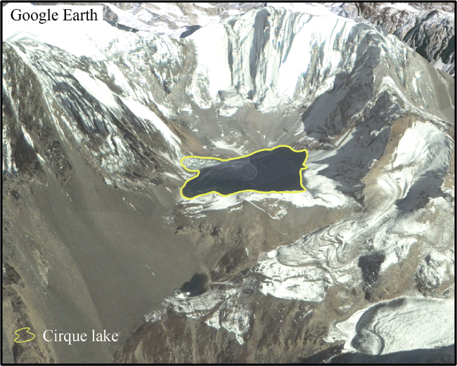
Due to the wide application of satellite remote sensing images in the inventory of glacial lakes and studies of their changes, the interpretation characteristics of different types of glacial lakes are given in the following. Before the interpretation of glacial lake types, it is noted that researchers should firstly determine the approximate distribution of glacial lakes based on the inventory of glaciers and digital elevation model (DEM) data; that is to say, lakes are only considered in the basin of modern glaciers. Meanwhile, although the lake is easily identified because of the obvious differences in the spectral characteristics of water body and its surrounding features in remote sensing images, it is very difficult to distinguish the types of glacial lakes scarcely by a single sensor or mono-phase remote sensing image. So other data sources and technologies should be needed, too. For instance, DEM data can be used to produce the mountain shadow so as to remove the wrong interpretation of glacial lakes; 3D visualization technology such as the Google Earth and high-resolution remote sensing images can be integrated to distinguish the type of glacial lakes.

3.1 Glacial erosion lake

Glacial erosion lake refers to the water body in the depression formed by erosion and abrasion of glacier in the process of glacier movement. At present, the common glacial erosion lakes were mostly formed by erosion of Quaternary glaciers. These glacial lakes were mainly supplied by atmospheric precipitation and had few modern glaciers in their upper part. As mentioned above, if no modern glaciers exist in the upper lakes, these lakes will not belong to glacial lakes. That is to say, ancient glacial erosion lakes should not be considered. According to the location and geomorphologic characteristics of glacial erosion lakes, they can be divided into the following 3 subclasses.
3.1.1 Cirque lake
The outstanding feature of the cirque lake is that it is located in the cirque. The typical cirque is like an arm-chair surrounded by three steep rock walls and a high reverse rock sill (see Figure 1, the centroid coordinates of the lake are 29°42'18"N, 96°18'32"E). Cirque lakes are usually small and near the equilibrium-line altitude (ELA) of glaciers. In the identification of cirque lake based on remote sensing images, it is necessary to use slope data derived from DEM data or Google Earth software to check the consistency between terrain features of glacial lakes and the cirque. If its terrain features satisfy the shape of the cirque, glacial lakes can be classified into cirque lake.
3.1.2 Glacial valley lake
Large glaciers usually formed a U-shaped valley being steep and straight on both sides and
flat at the bottom by laterally eroding in tributary and downward eroding on the glacier bed. Glacial meltwater and atmospheric precipitation flowed into the valley and then constituted a lake, namely glacial valley lake. This kind of glacial lakes were usually larger and far from modern glaciers. In order to expediently distinguish with moraine-dammed lakes since the Little Ice Age (LIA) and consider their potential danger on the downstream areas, some lakes in alpine region could been classified into glacial valley lake. According to the distance from the Akkol Lake to its supply glacier (Kanas Glacier) in the Altay Mountains and the area of Kanas Glacier (Figure 2), it is suggested that the identification of glacial valley lake can be based on the following criteria: (1) the morphology of lake should be U shaped; (2) there should be large glacier with an area of above 20 km2 in the upper lake; (3) the distance from lake to its supply glacier should be less than 15 km so as to distinguish with tectonic lakes.
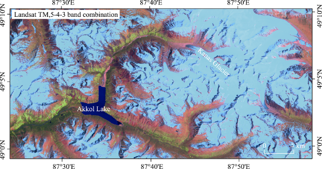
Figure 2 Glacial valley lake
3.1.3 Other glacial erosion lake
Glacial lakes formed by glacier erosion, which are difficult to be identified by morphological features and do not belong to the other types describing in the flowing, can be classified as other glacial erosion lake.

3.2 Moraine-dammed lake

Moraine-dammed lake is a water body between moraine ridge and glacier due to the obstruction of moraine ridge. According to the location, moraine-dammed lakes can be divided into 3 subclasses: end moraine-dammed lake, lateral moraine-dammed lake and moraine thaw lake.
3.2.1 End moraine-dammed lake
When glacier retreats, glacial meltwater accumulated in the space between glacier terminus and end moraine ridge, then formed a lake, namely end moraine-dammed lake. This kind of moraine-dammed lake is the main type causing glacial lake outburst flood or debris flow in the Himalayas and Nyainqentanglha Mountains. End moraine-dammed lakes are usually easy to distinguish in the remote sensing image because they are mostly linked to glacier terminus or the distance between them is very small (Figure 3a). In addition, the end moraine ridge uplifting is clear in the Google Earth software (Figure 3b), which can help to identify the end moraine-dammed lake, too. In the downstream of larger glacier terminus, there are usually several end moraine ridges and some lakes are formed among them. These lakes are mainly supplied by glacial meltwater and are formed by glaciation, so they can be classified as end moraine-dammed lake. Based on the measurement among these lakes in the Himalayas, the distance between the upper and the lower end moraine-dammed lakes is less than 2.0 km. In other words, the lakes with a distance being far from the upper end moraine-dammed lake than 2.0 km should be not identified as end moraine-dammed lake.
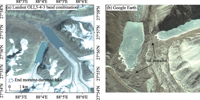
Figure 3 End moraine-dammed lake
3.2.2 Lateral moraine-dammed lake
Lateral moraine-dammed lake refers to the water body beside the lateral moraine ridge of glacier. These glacial lakes usually appear around the larger valley glacier and are formed by main valley glacier blocking the meltwater of tributary valley glacier. For instance, there are 5 lateral moraine-dammed lakes beside the Ngozumpa Glacier which is the largest glacier in the southern Mount Everest (Figure 4), and the third Gokyo Lake with an area of 0.59 km2 is the biggest one.
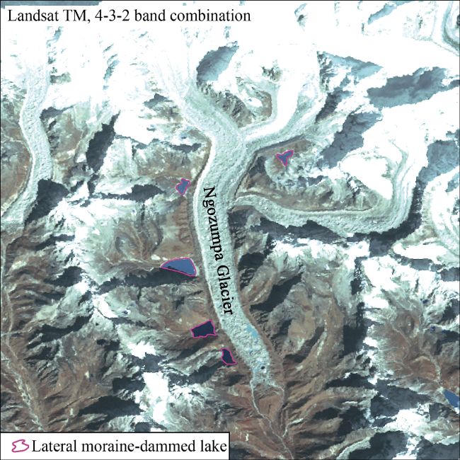
Figure 4 Lateral moraine-dammed lake
3.2.3 Moraine thaw lake
In the end/lateral moraine ridge of glacier, there are usually many but small ponds (Figure 5), which are named as glacial thaw lake or moraine-dammed lake (Yi and Cui, 1994; Wang et al., 2016). The principal agent controlling these lakes is freeze-thaw process. For example, dead ice within the moraine ridge melts due to the temperature rising, and then the surface sinks and forms the depression retaining water. Although these ponds do not receive glacial meltwater but are formed by the dead ice meltwater of glacier, they can be classified as glacial lakes, namely moraine thaw lake. It should be pointed out that thaw lakes widely distributed in rock glacier and frozen ground region do not belong to moraine thaw lake, and they should be eliminated in the inventory of glacial lakes.
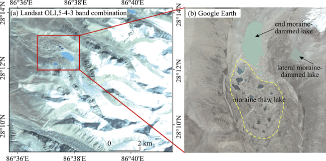
Figure 5 Moraine thaw lake (water body in blue-green color within the yellow-color polygon in (b)

3.3 Ice-blocked lake

Whether the glacier advanced and blocked the valley or the branch glacier rapidly retreated and was separated from the main glacier, they all resulted in the water accumulation, and then formed a lake. The common feature of these lakes is that their dams are composed of glacier ice, so they can be named as ice-blocked lake. According to their forming mechanism, ice-blocked lakes can be divided into advancing glacier-blocked lake and other glacier-blocked lake. The representation of the former is Kyagar Thso Lake located in the Yarkant River basin in China (Zhang et al., 1989; Wang et al., 2009). An example of the latter is Merzbacher Lake near the South Inylchek Glacier in Kyrgyzstan (Liu et al., 1998; Shen et al., 2009). Other glacier-blocked lakes also exist in the interior of the Tibetan Plateau (Figure 6), which has not been previously reported. For advancing glacier-blocked lakes, they usually survived for a few months to one year affected by temperature increase in low altitude and lake water erosion (Wang et al., 2009). For other glacier-blocked lakes, their evolution presented different characteristics. For example, Merzbacher Lake outburst floods mostly occurred in July - September and caused 50 GLOF events from 1932 to 1997 (Liu et al., 1998), showing a life cycle of glacier-blocked lake to some extent. But for glacier-blocked lakes in the interior of the Tibetan Plateau, they are usually stable.
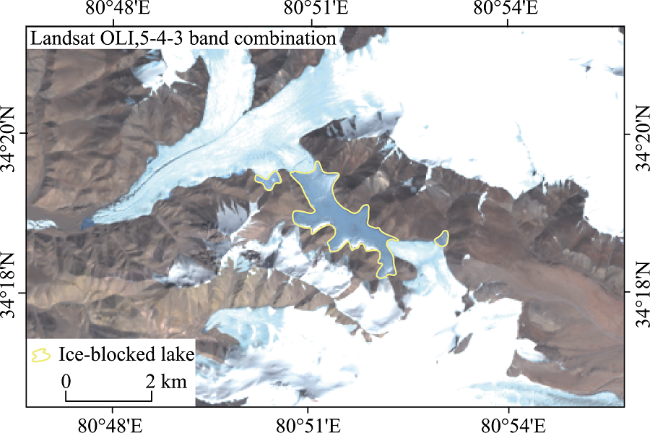
Figure 6 Ice-blocked lake over the Tibetan Plateau

3.4 Supraglacial lake

Supraglacial lake refers to the water body on the surface of glacier due to different ablation. These lakes usually appear on the surface of ablation zone of debris-covered glaciers. As seen in Figure 7, there are many supraglacial lakes in Rongbuk Glacier on the northern Mount Everest, the largest of which had an area of 0.47 km2 in 2016. In Tomur region of Tianshan Mountains, there are also many supraglacial lakes in some debris-covered glaciers, such as Tomur Glacier, Tugaibieliqi Glacier, Qong Terang Glacier, Koxkar Baxi Glacier, etc. When supraglacial lakes are connected with the drainage system inside the glacier, the lake water can be quickly exhausted. So supraglacial lakes change rapidly in annual and inter-annual scales. In view of the spatial resolution of Landsat TM/ETM+/OLI remote sensing images widely used, the quick variation of supraglacial lake, and being the origin of moraine-dammed lake (Richardson and Reynolds, 2000), it is suggested that the supraglacial lake with an area of above 0.02 km2 can be collected in the inventory of glacial lakes. The main difference between supraglacial lake and moraine thaw lake is their locations: the former is located on the surface of glacier; the latter is located on the moraine ridge of glacier.
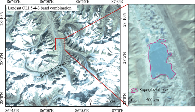
Figure 7 Supraglacial lake

3.5 Subglacial lake

The water body within the glacier can be named as subglacial lake. It had been found that there were more than 140 subglacial lakes under the Antartic ice sheet, the largest one was the Vostok Lake (Wingham et al., 2006). For alpine glaciers, lakes like subglacial lake had not been reported until now. However, small supraglacial lakes possibly exist in the distribution region of maritime glaciers such as southeastern Tibetan Plateau, because the drainage channels under the glacier are well developed. It is impossible to identify subglacial lake only relying on satellite remote sensing image, other instrument like ground penetrating radar (GPR) is needed. For building a complete classification system of glacial lake, subglacial lake is listed, but it can be removed in the inventory of glacial lakes based on satellite remote sensing images.

3.6 Other glacial lake

Except for 5 classes of glacial lake mentioned above, the water body formed by landslide, rock collapse, avalanche and debris flow blocking the valley in the glaciation area is named as other glacial lake. This kind of lake belongs to dammed lake and has a great potential harm to the downstream settlements, roads, hydropower stations and other infrastructures. Therefore, it should be taken into account in the inventory of glacial lakes. The first basis for identifying the other glacial lake is its dam which can be examined from the high-resolution remote sensing images. The second is that the appearance of the other glacial lake is usually related to the earthquake, debris flow and other geologic activities, and there is an obvious change of lake size around the time. For instance, the debris flow caused by Ranzeria Co Lake outburst formed two glacial lakes in Jiali County (Sun et al., 2014). The quantitative index of identifying the other glacial lake is suggested that the distance from the glacier terminus is below 10 km (Wang et al., 2013; Zhang et al., 2015).

4 Conclusions

As an important object of the cryospheric science, glacial lakes are not only closely related to the climate change and glacier movement, but also play a role on mountain disaster chain. Therefore, glacial lakes had been paid more and more attentions by many scientists and governments. In this paper, the definition of glacial lake was comprehensively discussed. It was noted that the definition was based on two perspectives of glaciation and glacial meltwater. But the fuzzy of spatial and temporal information made the poor operability in the inventory of glacial lakes. In short, it is difficult to determine whether one lake is a glacial lake or not. Theoretically, a glacial lake can be defined as the natural water body formed in the depression by glaciation since the LGM. However, the controversy of glacial coverage area in the LGM and researches’ knowledge deficiency of Quaternary glaciology also caused difficulties of identifying glacial lakes based on theoretical concept of glacial lake. On the consideration of the interest of glacial lakes’ studies, an alternative definition of glacial lake was proposed, i.e. glacial lake could be defined as the natural water mainly supplied by modern glacial meltwater or formed in glacier moraine’s depression. Meanwhile, a complete classification system of glacial lake was proposed based on its formation mechanism, topographic feature and geographical position. Glacial lakes were classified as 6 classes and 8 subclasses: glacial erosion lake (including cirque lake, glacial valley lake and other glacial erosion lake), moraine-dammed lake (including end moraine-dammed lake, lateral moraine-dammed lake and moraine thaw lake), ice-blocked lake (including advancing glacier-blocked lake and other glacier-blocked lake), supraglacial lake, subglacial lake and other glacial lake.
Although this paper attempted to provide the features or quantitative indices for identifying different types of glacial lakes using satellite remote sensing images, and emphasized that the existence of modern glaciers was the primary basis for distinguishing a glacial lake, there were still some problems in the inventory of glacial lakes. When glaciers previously existed in the First Chinese Glacier Inventory and there were glacial lakes in the downstream, if these glaciers disappeared in the Second Chinese Glacier Inventory, did these lakes belong to glacial lakes? So it is very important to ensure the consistency of subject. In addition, the quantitative indices proposed for identifying some types of glacial lakes were derived from the typical glacial lakes, and their representativeness needs to be further studied.

The authors have declared that no competing interests exist.

[1]
Björnsson H, 2003. Subglacial lakes and jökulhlaups in Iceland.Global & Planetary Change, 35(3/4): 255-271.Active volcanoes and hydrothermal systems underlie ice caps in Iceland. Glacier–volcano interactions produce meltwater that either drains toward the glacier margin or accumulates in subglacial lakes. Accumulated meltwater drains periodically in j02kulhlaups from the subglacial lakes and occasionally during volcanic eruptions. The release of meltwater from glacial lakes can take place in two different mechanisms. Drainage can begin at pressures lower than the ice overburden in conduits that expand slowly due to melting of the ice walls by frictional and sensible heat in the water. Alternatively, the lake level rises until the ice dam is lifted and water pressure in excess of the ice overburden opens the waterways; the glacier is lifted along the flowpath to make space for the water. In this case, discharge rises faster than can be accommodated by melting of the conduits. Normally j02kulhlaups do not lead to glacier surges but eruptions in ice-capped stratovolcanoes have caused rapid and extensive glacier sliding. J02kulhlaups from subglacial lakes may transport on the order of 10 7 tons of sediment per event but during violent volcanic eruptions, the sediment load has been 10 8 tons.

DOI

[2]
Cao X C, Liu Z Z, Li W S, 2016. Glacial lake mapping and analysis of the potentially dangerous glacial lakes before Nepal 4 25 Earthquake in 2015.Journal of Glaciology and Geocryology, 38(3): 573-583. (in Chinese)Because of the impact of earthquake,glacial slides,ice avalanches,landslides and debris flow s which were located in the upstream of glacial lakes would flow into the lakes,and the shock wave or heading up made ice dams or moraine dams collapsed suddenly,leading to the glacial lakes outburst quickly and causing floods or flood mudslides. By combining Landsat-8 remote sensing images and using the method of artificial interpretation,glacial lake data in Nepal earthquake affected zones before the earthquake occurred on April 25,2015 were reconstructed,which provided important data support for China and Nepal earthquake relief. Then using the history remote sensing images to extract glacial lakes data before the earthquake,making geospatial analysis of the history glacial lake data and the new est data,calculating area change and length change of the glacial lakes,finally combining the data of the seismic peak ground acceleration data of Nepal earthquake occurred on April25,2015,the potentially dangerous glacial lakes are identified. The results show that there were 1 847 glacial lakes with area more than 0. 02 km~2 in the study areas,with a total area of 263. 18 km~2,including 87 rapidly expanding glacial lakes and 49 potentially dangerous glacial lakes in the zones affected the earthquake; these potentially dangerous glacial lakes should be paid more attentions to.

[3]
Carey M, 2005. Living and dying with glaciers: People’s historical vulnerability to avalanches and outburst floods in Peru.Global & Planetary Change, 47(2-4): 122-134.Human populations worldwide are vulnerable to natural disasters. Certain conditions—such as geographical location or people's income level—can affect the degree to which natural disasters impact people's homes and livelihoods. This paper suggests that vulnerability to natural disasters increases when local people, scientists, and policymakers do not communicate and trust each other. Additionally, a breakdown in interaction and confidence among these groups can disrupt the implementation of sound science or well-intentioned policies. This case study analyzes how local people, scientists, and government officials responded to glacier hazards in Peru's Cordillera Blanca mountain range. Cordillera Blanca glacier retreat since the late-19th century has triggered some of the world's most deadly avalanches and glacial lake outburst floods. Although a Peruvian glaciology and lakes security office has “controlled” 35 Cordillera Blanca glacial lakes, 30 glacier disasters have killed nearly 30,000 people in this region since 1941. A lack of local faith in government officials and scientists as well as the State's failure to follow scientists' warnings about potential disasters have endangered or led to the death of thousands of local residents, many of which remain living in hazard zones today.

DOI

[4]
Cenderelli D A, Wohl E E, 2001. Peak discharge estimates of glacial-lake outburst floods and “normal” climatic floods in the Mount Everest region, Nepal.Geomorphology, 40(1): 57-90.Glacial-lake outburst floods (GLOFs) in the Mount Everest region of Nepal on 3 September 1977 and 4 August 1985 dramatically modified channels and valleys in the region by eroding, transporting, and depositing large quantities of sediment for tens of kilometers along their flood routes. Prior to this research, the GLOF discharges had not been determined and the hydrology of ormal climatic floods (SHFFs: seasonal high flow floods) was not known. A one-dimensional step-backwater flow model was utilized, in conjunction with paleostage indicators, to estimate the peak discharges of the GLOFs and SHFFs and to reconstruct the hydrology and hydraulic conditions of the GLOFs at 10 reaches and SHFFs at 18 reaches. The most reliable GLOF and SHFF peak discharge estimates were upstream from constrictions where there was critical-depth control. The peak discharge of the 1977 GLOF at 8.6 km from the breached moraine was approximately 1900 m 3/s. At 7.1 km downstream from the breached moraine, the 1985 GLOF discharge was estimated at 2350 m 3/s. At 27 km downstream from the breached moraine, the 1985 GLOF attenuated to an estimated discharge of 1375 m 3/s. The peak discharges of SHFFs ranged from 7 to 205 m 3/s and were positively correlated with increasing drainage area. The GLOF discharges were 7 to 60 times greater than the SHFF discharges with the greatest ratios occurring near the breached moraines. The downstream decline in the ratio between the GLOF discharge and SHFF discharge is the result of the downstream attenuation of the GLOF and the increased discharge of the SHFF because of increased contributing drainage area and the increased effects of monsoonal precipitation at lower elevations.

DOI

[5]
Chen C, Zheng J H, Liu Y Qet al., 2015. The response of glacial lakes in the Altay Mountains of China to climate change during 1992-2003.Geographical Research, 34(2): 270-284. (in Chinese)Glacial lakes of the Altay Mountains in China during the past 20 years were interpreted and classified based on the remote sensing images of Landsat TM(1992)/ETM+(2002)/OLI(2013) respectively, with properties including basin, altitude and slope gained from SRTM DEM by spatial overlay analysis in GIS. The features of temporal-spatial distribution and variation of glacial lakes during 1992-2013 and factors which impacted the evolution of glacial lakes in this area were discussed. The results indicate that:(1) there were 1147 glacial lakes in the Altay Mountains of China in 2013, with a total area of 101.628 km2, and both the number and area of glacial lakes increased during the past two decades.(2) The responses of ice-scour lakes and moraine-dammed lakes to climate change were totally different.(3) With temperature rising, the peak of profit and loss of ice-scour lakes reached a higher altitude, and the variation of moraine-dammed lakes became more unstable.(4) Westerly circulation had a significant influence on the glacial lakes, the precipitation on the west-facing slope was sufficient, therefore the west-facing ice-scour lakes varied little, while the west-facing moraine-dammed lakes kept expanding as the profit constantly overmatched the loss.(5) Owing to the lower elevation, glacial lakes in this region were sensitive to climate change than other alpine-plateau areas in western China over the past two decades, both surplus and deficit of water were of high quantity, resulting in few net increment after lake water balance.(6) The magnitude of temperature rise and precipitation reduction during 1992-2002 were larger compared with the period 2002-2013,and the quantity of water surplus and deficit of glacial lakes in spatial units of each size was greater compared with the 2002-2013 period. There is a positive correlation between water surplus and deficit of glacial lakes and the range of temperature rise and precipitation reduction.

DOI

[6]
Chen Y N, Xu C C, Chen Y Pet al., 2010. Response of glacial-lake outburst floods to climate change in the Yarkant River basin on northern slope of Karakoram Mountains, China.Quaternary International, 226(1/2): 75-81.Based on the glacial flood events and climate change in the Yarkant River basin during the past 50 years, the study investigated the long-term change of temperature and precipitation, the characteristics of glacial floods, the origin of sudden flood release, the suggested flood mechanism of glacial lakes and the relationship between glacial floods and climate change. Results showed that there was an obvious increase in the temperature of the basin since 1987. Specifically in the mountainous area, the significantly increasing temperature in the summer and autumn seasons accelerated the melting rate of glaciers and caused glacial-lake burst. Sudden flood release occurred frequently. The frequency of glacial-lake outburst floods was 0.4 times/a during the period 1959–1986 and increased to 0.7 times/a during 1997–2006. Peak discharge also increased. There were seven floods with peak discharge over 400002m 3 /s from 1959–2006, and three occurred after 1997. The increasing frequency and magnitude of glacial outburst floods mirrored the effect of climate warming on glaciers.

DOI

[7]
Clague J J, Evans S G, 2000. A review of catastrophic drainage of moraine-dammed lakes in British Columbia. Quaternary Science Reviews, 19(17/18): 1763-1783.Moraine-dammed lakes are common in the high mountains of British Columbia. Most of these lakes formed when valley and cirque glaciers retreated from advanced positions achieved during the Little Ice Age. Many moraine dams in British Columbia are susceptible to failure because they are steep-sided, have relatively low width-to-height ratios, comprise loose, poorly sorted sediment, and may contain ice cores or interstitial ice. In addition, the lakes commonly are bordered by steep slopes that are prone to snow and ice avalanches and rockfalls. Moraine dams generally fail by overtopping and incision. The triggering event may be a heavy rainstorm, or an avalanche or rockfall that generates waves that overtop the dam. The dam can also be overtopped by an influx of water caused by sudden drainage of an upstream ice-dammed lake (j kulhlaup). Melting of moraine ice cores and piping are other possible failure mechanisms. Failures of moraine dams in British Columbia produce destructive floods orders of magnitude larger than normal streamflows. Most outburst floods are characterized by an exponential increase in discharge, followed by an abrupt drop to background levels when the water supply is exhausted. Peak discharges are controlled by dam characteristics, the volume of water in the reservoir, failure mechanisms, and downstream topography and sediment availability. For the same potential energy at the dam site, floods from moraine-dammed lakes have higher peak discharges than floods from glacier-dammed lakes. The floodwaters may mobilize large amounts of sediment as they travel down steep valleys, producing highly mobile debris flows. Such flows have larger discharges and greater destructive impact than the floods from which they form. Moraine dam failures in British Columbia and elsewhere are most frequent following extended periods of cool climate when large lateral and end moraines are built. A period of protracted warming is required to trap lakes behind moraines and create conditions that lead to dam failure. This sequence of events occurred only a few times during the Holocene Epoch, most notably during the last several centuries. Glaciers built large moraines during the Little Ice Age, mainly during the 1700s and 1800s, and lakes formed behind these moraines when climate warmed in the 1900s. Twentieth-century climate warming is also responsible for recent moraine dam failures in mountains throughout the world. Warming from the late 1800s until about 1940 and again from 1965 to today destabilized moraine dams with interstitial or core ice. The warming also forced glaciers to retreat, prompting ice avalanches, landslides, and j kulhlaups that have destroyed some moraine dams.

DOI

[8]
Cui P, Chen R, Xiang L Zet al., 2014. Risk analysis of mountain hazards in Tibetan Plateau under global warming.Progressus Inquisitiones De Mutatione Climatis, 10(2): 103-109. (in Chinese)Based on the mountain hazards events in the Tibetan Plateau during the period of 1930-2010,the impacts of global wanning on mountain hazards in alpine area were analyzed.Under the circumstance of global warming,glacial lake outburst disaster and glacial debris tended to be more active.Disaster chain was apparent and showed a tendency of spatial and temporal extension,associated with the increasing occurrences of catastrophe.It showed a climatic characteristics of rain and heat occurring in the same period,which constituted a favorable combination for the formation of glacial debris in the southeast region of Tibet.Building distribution in debris-flow risky areas of Sangdeng Gully and Ganong Gully with an area of 0.014 km~2 in 1988 extended to 1.004 km~2 in 2012,economic activity overlapped with the high risk areas coupled with the increasing disaster risk due to climate change,and thus disaster risk in mountain regions significantly increased.The above results provide evidence about the impact of climate change on mountain hazards in Tibetan Plateau and preliminarily describe characteristics of the impact,which will help to reduce mountain hazards and further understand the corresponding impact mechanism.

DOI

[9]
Ding Y J, Liu S Y, Ye B Set al., 2006. Climatic implications on variations of lakes in the cold and arid regions of China during the recent 50 years.Journal of Glaciology and Geocryology, 28(5): 623-632. (in Chinese)The study objects in this work are lakes in the Tibetan Plateau,Inner Mongolia and Xinjiang regions.Dynamic relations between lake and climate change are revealed through analyzing the variations of typical lakes and climate change in each lake regions.The relationship between variations in area of lake and climate change in phase is analyzed in a regional scale.It is found that the lakes locating in the cold and the arid regions of China have highly sensitivity to the climate change.The lakes in the Inner Mongolia lake region are affected mainly by precipitation in view of climate.As a whole,precipitation has more noticeable impact on the lakes in the Xinjiang lake region.But Air temperature also has definite impact due to glaciers in the region.Precipitation and air temperature have the different effects on different lakes on the Tibetan Plateau.The relationship between lake and climate change is even more complicated in a regional scale.The lakes,as a whole,tend to shrink under the conditions of precipitation increasing and air temperature rising on the Tibetan Plateau.

DOI

[10]
Emmer A, Merkl S, Mergili M, 2015. Spatiotemporal patterns of high-mountain lakes and related hazards in western Austria.Geomorphology, 246: 602-616.We distinguished three phases of development of bedrock-dammed lakes: (a) a proglacial, (b) a glacier-detached, and (c) a nonglacial phase. The dynamics — and also the susceptibility of a lake to GLOFs — decrease substantially from (a) to (c). Lakes in the stages (a) and (b) are less prominent in our study area, compared to other glacierized high-mountain regions, leading us to the conclusion that (i) the current threat to the population by GLOFs is lower but (ii) the future development of emerging lakes has to be monitored carefully.

DOI

[11]
Engel Z, Sobr M, Yerokhin S A, 2012. Changes of Petrov Glacier and its proglacial lake in the Akshiirak massif, central Tien Shan, since 1977.Journal of Glaciology, 58(208): 388-398.A combination of remotely sensed data, field mapping, bathymetric survey and geophysical soundings is used to describe the recent changes in the terminal area of Petrov glacier, the largest glacier in the Akshiirak massif, central Tien Shan. According to our results, three periods of accelerated glacier retreat (1977–80, 1990–95 and 2008–09) can be distinguished since 1977. The largest recession occurred in 1990–95 when the glacier retreated by 54 8 m a. Accelerated glacier retreat affected the enlargement rate of Petrov lake, which increased by 0.04–0.1 kmaand by 1.3–2.2 10main the last three decades. Since 1995, the mean annual retreat rate of the lake-calving northern glacier section has been up to three times higher than the retreat rate of the land-terminating southern section. The calving flux ranged from 2.5 to 4.6 10main 2003–09, resulting in a total glacier mass loss of (17.7 0.4) 10m. The calving terminus of Petrov glacier was >65 m thick in 2009 according to ground-penetrating radar measurements.

DOI

[12]
Fujita K, Suzuki R, Nuimura Tet al., 2008. Performance of ASTER and SRTM DEMs, and their potential for assessing glacial lakes in the Lunana region, Bhutan Himalaya.Journal of Glaciology, 54(185): 220-228.To assess the potential volume of a glacial lake outburst flood (GLOF) more precisely than in previous studies, we analyze ground survey data and remote-sensing digital elevation models (DEMs) around glacial lakes in the Lunana region, Bhutan. Based on a DEM generated from differential GPS ground surveys, we first evaluate the relative accuracies of DEMs produced by the Advanced Spaceborne Thermal Emission and Reflection Radiometer (ASTER) and the Shuttle Radar Topography Mission (SRTM). Root-mean-square errors of the altitudinal difference between these DEMs and ground survey data were 11.0 m for ASTER and 11.3 m for SRTM. These errors are similar to those of previous studies. We show that a topographical classification allows a better estimate of elevation on lakes/ponds, riverbeds and glaciers due to their flat surfaces, while the relative accuracy is worse over moraines and hill slopes due to their narrow ridges and steep slopes. Using the optical satellite images and the ground survey data, we re-evaluate the GLOF volume in 1994 as (17.2 5.3) 10m. We show GLOF-related information such as distance, altitudinal difference and gradient at possible outburst points where the lake level is higher than the neighboring riverbed and/or glacial lake.

DOI

[13]
Gao X, Wu L Z, Pradeep K M, 2015. Analysis of the characteristics of glacial lake variation in the Koshi River basin, the Himalayas based on RS and GIS.Journal of Glaciology and Geocryology, 37(3): 557-569. (in Chinese)Glacier retreating and increasing number and area of glacial lakes are considered as an important evidence w hich indicates climate change; the increasing area of lakes makes the lake more dangerous. Therefore,study of the change of glacial lakes is of great significance for research of climate change and glacial lake disaster. Based on Landsat TM / ETM + remote sensing images,using the method of artificial interpretation,three sets of glacial lake data of the Koshi River basin in 1990,2000 and 2010,w ere obtained,the area and length change of 199 glacial lakes,w hich w ere surviving lakes w ith area greater than 0. 1 km2,were analyzed,the follow ings w ere revealed: 1) The total area of glacial lakes w ith area larger than 0. 1 km2 in the basin w as increasing,from 73. 59 km2 in 1990 to 86. 12 km2 in 2010; 2) In the basin,variation of glacial lakes on the southern slopes of the Himalayas w as different from that on the northern slopes of the Himalayas,for example,on the northern slopes,the more changed glacial lakes w ere located in betw een the elevations of 4 800 m and 5600 m,w hile on southern slopes,they w ere located in betw een the elevations of 4 300 m and 5 200 m. On the northern slopes,65% of glacial lakes w as expanding,and the main expanded area w as located in the contact of lake w ith glacier terminal; on the southern slopes,32% of glacial lakes w as expanding,and the main expanding w as supra-glacial lake expanding; 3) On the average,the change velocity of glacial lake on northern slopes is slightly greater than that on the southern slopes in the basin.

[14]
Huggel C, Kääb A, Haeberli Wet al., 2002. Remote sensing based assessment of hazards from glacier lake outbursts: A case study in the Swiss Alps.Canadian Geotechnical Journal, 39(2): 316-330.

DOI

[15]
Institute of Mountain Hazards and Environment, the Chinese Academy of Sciences and Water Conservancy Ministry, the Traffic Department of the Tibet Autonomous Region, 1999. Debris Flow and Environment in Tibet. Chengdu: Sichuan University Publishing House.

[16]
Janský B, Šobr M, Engel Z, 2010. Outburst flood hazard: Case studies from the Tien-Shan Mountains, Kyrgyzstan.Limnologica - Ecology and Management of Inland Waters, 40(4): 358-364.More than 2000 of mountain lakes covering more than 0.1 ha exist in a territory of Kyrgyzstan. Nearly 20% of them are dangerous because of instability of lake dams, frequent overflows and melting of buried ice inside the moraine dams. According to the Kyrgyz lake inventory, 328 lakes are at risk of outburst and 12 lakes are considered as actually dangerous. Since 1952 more than 70 disastrous cases of lake outbursts have occurred. The majority of the endangered lakes belong to one of the three genetic types: morainic-glacier, supraglacial and lake dammed by landslides and debris flows. Petrov, Adygine and Koltor lakes were selected and studied in the Tien-Shan Mountains as case studies of the most frequent genetic types of hazardous lakes. Observations were focused on the morphology of the lake basin and the surrounding relief, outflow pattern and processes controlling the development of lake. For the hazard assessment, evolution of glaciers and lakes was reconstructed using historical reports, aerial photographs and satellite images.

DOI

[17]
Kargel J S, Leonard G J, Shugar D Het al., 2016. Geomorphic and geologic controls of geohazards induced by Nepal’s 2015 Gorkha earthquake. Science, 351(6269): aac8353. DOI: 10.1126/science.aac8353.Abstract The Gorkha earthquake (M 7.8) on 25 April 2015 and later aftershocks struck South Asia, killing ~9,000 and damaging a large region. Supported by a large campaign of responsive satellite data acquisitions over the earthquake disaster zone, our team undertook a satellite image survey of the earthquakes' induced geohazards in Nepal and China and an assessment of the geomorphic, tectonic, and lithologic controls on quake-induced landslides. Timely analysis and communication aided response and recovery and informed decision makers. We mapped 4,312 co-seismic and post-seismic landslides. We also surveyed 491 glacier lakes for earthquake damage, but found only 9 landslide-impacted lakes and no visible satellite evidence of outbursts. Landslide densities correlate with slope, peak ground acceleration, surface downdrop, and specific metamorphic lithologies and large plutonic intrusions. Copyright 2015, American Association for the Advancement of Science.

DOI PMID

[18]
Le M H, Tang C, Zhang D Det al., 2014. Logistic regression model-based approach for predicting the hazard of glacial lake outburst in Tibet.Journal of Natural Disasters, 23(5): 177-184. (in Chinese)Based on field investigation, RS image and literature, this paper selects 32 glacial lakes as the research samples for hazard analysis. According to the regional characteristics of the research object, six predictor indices, crest width of the lake dam, ratio of the dam crest freeboard to dam crest height, lake-glacier distance, glacier tongue slope, lake area, and glacier area, were chosen as the variables, and then through the logistic regression analysis of the samples, a model of predicting the hazard of glacial-lake outburst in Tibet was proposed. With the cross-validation of logistic regression model based on the classification threshold value of 50%, the predictive model correctly classifies 82% of the lakes with outburst and 95% of the lakes without outburst, the overall accuracy being 91%. By probability ranges, the outburst hazards were classified as low(0.80).

DOI

[19]
Li J L, Sheng Y W, Luo J C, 2011. Automatic extraction of Himalayan glacial lakes with remote sensing.Journal of Remote Sensing, 15(1): 29-35. (in Chinese)The paper develops an automatic lake delineation algorithm based on"global-local"iterative scheme.The author uses NDWI(Normalized Difference Water Index) as the water identification index for the threshold segmentation process,and the slope maps and the shaded relief maps are applied in the algorithm to differentiate the shadow features from water features. Based on these methods,an automatic lakes delineation scheme is proposed to map the glacial lakes with Landsat Imagery in Himalayas mountains area.The results show that the proposed algorithm has good performance on lake mapping over the mountain areas,and lakes can be extracted automatically,accurately and efficiently,while most of melting glaciers and hill shadow features are eliminated from the segmentation processing.

DOI

[20]
Liao S F, Wang X, Xie Z Cet al., 2015. Changes of glacial lakes in different watersheds of Chinese Himalaya during the last four decades.Journal of Natural Resources, 30(2): 293-303. (in Chinese)

[21]
Liu C L, Tong L Q, Qi S Wet al., 2016. Remote sensing investigation and influence factor analysis of glacier lake outburst potential in the Himalayas.Remote Sensing for Land and Resources, 28(3): 110-115. (in Chinese)Under the impact of formation conditions and natural environment,moraine- dammed lake outbursts take place frequently and then give rise to floods and mudslides,which menaces people's production,life,survival and development and becomes one of the great geohazard hidden dangers in the Himalayas. Using Quick Bird and ETM data of remote sensing satellite and combining the investigations in field work,the authors studied the glacier lake outburst potential. The research results show that the areal distribution of glacier lakes presents a trend of decrease gradually from SE to NW in the Himalayas. Most of the glacier lakes are distributed in Shannan,Shigatse,Nyingchi and Ngari. The region of maximal distribution density is Lho- brag area of Shannan. It can be found that there are nineteen glacier lakes,all of which are moraine- dammed lakes that have outburst hazard potential.Among the nineteen glacier lakes,there are 13 glacier lakes having great outburst hazard potential and 6 glacier lakes having secondary great outburst hazard potential. It is also indicated that there are several trigger factors impacting instability of moraine- dammed lakes,whose foremost reasons are surge triggered by avalanche,bedrock collapse,and rock avalanche around the moraine- dammed lakes.

[22]
Liu J, Cheng Z, Su P, 2014. The relationship between air temperature fluctuation and glacial lake outburst floods in Tibet, China.Quaternary International, 321(2): 78-87.In recent years, disasters caused by Glacial Lake Outburst Floods (GLOFs) have taken place more frequently in Tibet than previously and have been the cause of considerable losses. Temperature fluctuations are believed a major influencing factor of GLOFs. However, if or how much climatic change influences GLOFs is a question that remains to be answered. In this paper, using 24 GLOFs related to 19 glacial lakes and temperature data from 14 meteorological stations, we explored the relationships between temperature variations on different temporal scales (annual, monthly, and daily) and GLOFs. There were three active periods for GLOFs in the 1960s, 1980s and 2000s in Tibet, when 16 of 24 GLOFs took place. All the studied GLOFs occurred in the ablation months (from May and September, and especially in July and August) and on ablation days with a monthly average temperature and daily average temperature that were both greater than 0 C. Based on the analysis of monthly and daily temperature, GLOFs depend on the coupled influence of ablation temperature and accumulation temperature; even the accumulation temperature may be important. Based on this, temperature increments were defined, representing the change from accumulation to ablation temperature with a significant impact on GLOFs. There is an altitude effect on GLOFs, in that lakes at lower altitude generally burst earlier, whereas those at a higher altitude burst later. The monthly and daily increments increase according to a similar power-law form with elevation.

DOI

[23]
Liu S Y, Cheng G D, Liu J S, 1998. Jokulhlaup characteristics of the Lake Mertzbakher in the Tianshan Mountains and its relation to climate change.Journal of Glaciology and Geocryology, 20(1): 30-35. (in Chinese)The relationship between jokulhlaup from the Lake Mertzbakher in the Tianshan Mts. and climatic parameters, esp. air temperatures, is analysed based on the long-term records of the outburst floods since 1956. It can be concluded that monthly air temperature variation, which gives rise to the change of ablation duration and rate of the South and North Inilchek Glaciers, play an important role in the fluctuations of the water level and the drainage of the Lake Mertzbakher. A general increasing trend has been prevailed in the temporal variation of peak and total discharges of the jokulhlaup floods of the lake. Such an increasing trend is well coincided with the regional warming in the Tianshan Mountains during the last few decades.

DOI

[24]
Liu X C, Xiao C D, 2011. Preliminary study of the Jiemayangzong Glacier and lake variations in the source regions of the Yarlung Zangbo River in 1974 - 2010.Journal of Glaciology and Geocryology, 33(3): 488-496. (in Chinese)Glaciers and lakes on the Tibetan Plateau play an important role in the earth's climatic system.Using 3S technology,the variations of Jiemayangzong Glacier and Lake in the last 37 a(1974—2010) are analyzed.Based on topographic map in 1974 and DEM derived from topographic map,TM,ETM+ and GPS data taken in 1990,2000,2005,2010 and 2009,the changes of the glacier and the terminal lake in different periods were studied.Results show that the glacierized area has decreased 5.02%(from 21.78 km2to 20.67 km2),the terminal of glacier has retreated 768m(in a rate of 21 m·a-1);Lake area has increased 63.7%(from 0.70 km2 to 1.14 km2),volume of the lake has increased about 9.8×10⁶ m3.Moreover,meteorologica1 record at Burang Station indicates that annua1 mean air temperature has had a dramatic increase,while precipitation has obviously decreased in the past 37 years;the warming/drying tendency of climate in this period is the major drive for the variations of Jiemayangzong Glacier and the terminal lake.More rapid glacial retreat and,probably,glacier-lake outburst would be expected if the climate warming and dry condition continue.

DOI

[25]
Ma R H, Yang G S, Duan H Tet al., 2011. China’s lakes at present: Number, area and spatial distribution.Science China Earth Sciences, 41(3): 394-401. (in Chinese)Based on 11004 satellite images from CBERS CCD and Landsat TM/ETM, changes in the spatial characteristics of all lakes in China were determined following pre-established interpretation rules. This dataset was supported by 6843 digital raster images (1:100000 and 1:50000), a countrywide digital vector dataset (1:250000), and historical literature. Comparative data were corrected for seasonal variations using precipitation data. There are presently 2693 natural lakes in China with an area greater than 1.0 km 2 , excluding reservoirs. These lakes are distributed in 28 provinces, autonomous regions and municipalities and have a total area of 81414.6 km 2 , accounting for 650.9% of China’s total land area. In the past 30 years, the number of newly formed and newly discovered lakes with an area greater than 1.0 km 2 is 60 and 131, respectively. Conversely, 243 lakes have disappeared in this time period.

DOI

[26]
O'Connor J E, Costa J E, 1993. Geologic and hydrologic hazards in glacierized basins in North America resulting from 19th and 20th century global warming.Natural Hazards, 8(2): 121-140.Alpine glacier retreat resulting from global warming since the close of the Little Ice Age in the 19th and 20th centuries has increased the risk and incidence of some geologic and hydrologic hazards in mountainous alpine regions of North America. Abundant loose debris in recently deglaciated areas at the toe of alpine glaciers provides a ready source of sediment during rainstorms or outburst floods. This sediment can cause debris flows and sedimentation problems in downstream areas. Moraines built during the Little Ice Age can trap and store large volumes of water. These natural dams have no controlled outlets and can fail without warning. Many glacier-dammed lakes have grown in size, while ice dams have shrunk, resulting in greater risks of ice-dam failure. The retreat and thinning of glacier ice has left oversteepened, unstable valley walls and has led to increased incidence of rock and debris avalanches.

DOI

[27]
Pradeep P K, Bajracharya S R, Joshi S P, 2001. Inventory of Glaciers, Glacial Lakes and Glacial Lake Outburst Floods. Monitoring and Early Warning Systems in the Hindu Kush-Himalayan Region: Nepal. Kathmandu: International Centre for Integrated Mountain Development.

[28]
Qin D H, Yao T D, Ding Y J et al., 2016. Glossary of Cryosphere Science. Beijing: China Meteorological Press.

[29]
Richardson S D, Reynolds J M, 2000. An overview of glacial hazards in the Himalayas.Quaternary International, 65/66: 31-47.Glaciers and snowfields can form potential hazards in the Himalayas, and in similarly glacierised regions of the world. Some glaciological phenomena can have significant impacts upon society over a short time scale (minutes–days), such as ice/snow avalanches and glacial floods. Other related hazards can be equally serious but less obvious when considered on a much longer time scale (months–years–decades), such as glacier volume fluctuations leading to water resource problems. Only when humans and their activities become vulnerable to glacier-related processes is there considered to be a hazard risk. As glaciers recede in response to climatic warming, the number and volume of potentially hazardous moraine-dammed lakes in the Himalayas is increasing. These lakes develop behind unstable ice-cored moraines, and have the potential to burst catastrophically, producing devastating Glacial Lake Outburst Floods (GLOFs). Discharge rates of 30,000 m 3 s 611 and run-out distances in excess of 200 km have been recorded. Despite the scale of the risk, it is possible to assess and mitigate hazardous lakes successfully. Hazard assessment using satellite images has been effective for remote areas of Bhutan, and remediation techniques successfully developed in the Peruvian Andes are now being deployed for the first time in Nepal.

DOI

[30]
Shen Y P, Wang G Y, Ding Y Jet al., 2009. Changes in Merzbacher Lake of Inylchek Glacier and glacial flash floods in Aksu River basin, Tianshan during the period of 1903-2009.Journal of Glaciology and Geocryology, 31(6): 993-1002. (in Chinese)The Kumarik River,which is the headwater of theAksu Riverand from the glaciated centre of Central Asia in the Mount Khan Tengry of Tianshan,drainage area of 12 816 km2(which of 2 306 km2in Kyrgyzstan) in which glacier area is 3 195 km2. Inylchek Glacier is the largest one with 61km length and an area cover of 748.4 km2. The glacial runoff is 54% of average annual runoff at Shehel Gauge Station. In the source region of Kumarik River,sandwiched between the South and the North Inylchek Glaciers,is the mysterious Merzbacher Lake,whichis thelargest glacial lakein Sary Jaz -Kumarik River Basin. Every year,and sometimes twice a year,the lake suddenly empties,only to refill again with the melted glaciers that surround. Merzbacher Lake glacial flash flood occurred 62 times and more than 90% frequency in the period of 1932-2008. Glaciers melt and glacier flash floods play a vital role in runoff supply and flood control security for theAksu River and the Tarim River in China. Over the past years,the Tianshan have started melting down with the increase in temperature leading to formation of increasing number of glacier-fed lakes. The total discharge of glacier flash floods is increasing to 3 108 4 108m3in 1990s from 1 108m3of 1960s-1970s,and the total flood volumeis up to 4.5 108m3. The Peak discharge has increased 32% from 1950s to 1990s.Glacier flash floods drainage in Merzbacher Lake by the river way under the ice to downstreamand the flood period often lasted a few days to more than two weeks. The changes in glacier mass balance in the Kumarik River Basin have significantly influences on glacial flash flood,the more glacier melt,the larger the peak discharge. With climate warming,the pressure of flood control is increasing in the lower reaches of the Aksu River. Therefore,it is vital to strengthen the observation and monitoring of the glaciers and the water levels of glacial lake,establish early warning systems for the forecasting of glacial lake outburst flood and downstream security.

DOI

[31]
Song C, Sheng Y, Ke Let al., 2016. Glacial lake evolution in the southeastern Tibetan Plateau and the cause of rapid expansion of proglacial lakes linked to glacial-hydrogeomorphic processes.Journal of Hydrology, 540: 504-514.Glacial lakes, as an important component of the cryosphere in the southeastern Tibetan Plateau (SETP) in response to climate change, pose significant threats to the downstream lives and properties of people, engineering construction, and ecological environment via outburst floods, yet we currently have limited knowledge of their distribution, evolution, and the driving mechanism of rapid expansions due to the low accessibility and harsh natural conditions. By integrating optical imagery, satellite altimetry and digital elevation model (DEM), this study presents a regional-scale investigation of glacial lake dynamics across two river basins of the SETP during 1988–201302and02further explores the glacial-hydrogeomorphic process of rapidly expanding lakes. In total 127802and021396 glacial lakes were inventoried in 198802and022013, respectively. Approximately 92.4% of the lakes in 2013 are not in contact with modern glaciers, and the remaining 7.6% includes 27 (1.9%) debris-contact lakes (in contact with debris-covered ice) and 80 (5.7%) cirque lakes. In categorizing lake variations, we found that debris-contact proglacial lakes experienced much more rapid expansions (6575%) than cirque lakes (657%) and non-glacier-contact lakes (653%). To explore the cause of rapid expansion for these debris-contact lakes, we further investigated the mass balance of parent glaciers and elevation changes in lake surfaces and debris-covered glacier tongues using time-series Landsat images, ICESat altimetry, and DEM. Results reveal that the upstream expansion of debris-contact proglacial lakes was not directly associated with rising water levels but with a geomorphological alternation of upstream lake basins caused by melting-induced debris subsidence at glacier termini. This suggests that the hydrogeomorphic process of glacier thinning and retreat, in comparison with direct glacial meltwater alone, may have played a dominant role in the recent glacial lake expansion observed across the SETP. Our findings assist in understanding the expansion mechanism of debris-contact proglacial lakes, which facilitates early recognition of potential glacial lake hazards in this region.

DOI

[32]
Song C, Sheng Y, Wang Jet al., 2017. Heterogeneous glacial lake changes and links of lake expansions to the rapid thinning of adjacent glacier termini in the Himalayas.Geomorphology, 280: 30-38.Glacier mass loss in the Himalayas has far-reaching implications for the alteration of regional hydrologic regimes, an increased risk of glacial lake outburst, downstream water resource abundance, and contributions to sea level rise. However, the mass losses of Himalayan glaciers are not well understood towing to the scarcity of observations and the heterogeneous responses of Himalayan glaciers to climate change and local factors (e.g., glacier surge, interacting with proglacial lakes). In particular, there is a lack of understanding on the unique interactions between moraine-dammed glacial lakes and their effects on debris cover on valley glacier termini. In this study, we examined the temporal evolution of 151 large glacial lakes across the Himalayas and then classified these glacial lakes into three categories: proglacial lakes in contact with full or partial debris-covered glaciers (debris-contact lakes), ice cliff-contact lakes, and non-glacier-contact lakes. The results show that debris-contact lakes experienced a dramatic areal increase of 36.5% over the years 2000 to 2014, while the latter two categories of lakes remained generally stable. The majority of lake expansions occurred at the glacier front without marked lake level rises. This suggests that the rapid expansion of these debris-contact lakes can be largely attributed to the thinning of debris-covered ice as caused by the melting of glacial fronts and the subsequent glacial retreat. We reconstructed the height variations of glacier fronts in contact with 57 different proglacial lakes during the years 2000 to 2014. These reconstructed surface elevation changes of debris-covered, lake-contact glacier fronts reveal significant thinning trends with considerable lowering rates that range from 1.0 to 9.7 m/y. Our study reveals that a substantial average ice thinning of 3.9 m/y occurred at the glacier fronts that are in contact with glacial lakes.

DOI

[33]
Stokes C R, Popovnin V, Aleynikov Aet al., 2007. Recent glacier retreat in the Caucasus Mountains, Russia, and associated increase in supraglacial debris cover and supra-/proglacial lake development.Annals of Glaciology, 46(1): 195-203.This paper reports changes in supraglacial debris cover and supra-/proglacial lake development associated with recent glacier retreat (1985-2000) in the central Caucasus Mountains, Russia. Satellite imagery (Landsat TM and ETM+) was used to map the surface area and supraglacial debris cover on six neighbouring glaciers in the Adylsu valley through a process of manual digitizing on a false-colour composite of bands 5, 4, 3 (red, green, blue). The distribution and surface area of supraglacial and proglacial lakes was digitized for a larger area, which extended to the whole Landsat scene. We also compare our satellite interpretations to field observations in the Adylsu valley. Supraglacial debris cover ranges from 25% on individual glaciers, but glacier retreat between 1985 and 2000 resulted in a 3-6% increase in the proportion of each glacier covered by debris. The only exception to this trend was a very small glacier where debris cover did not change significantly and remote mapping proved more difficult. The increase in debris cover is characterized by a progressive upglacier migration, which we suggest is being driven by focused ablation (and therefore glacier thinning) at the up-glacier limit of the debris cover, resulting in the progressive exposure of englacial debris. Glacier retreat has also been accompanied by an increase in the number of proglacial and supraglacial lakes in our study area, from 16 in 1985 to 24 in 2000, representing a 57% increase in their cumulative surface area. These lakes appear to be impounded by relatively recently lateral and terminal moraines and by debris deposits on the surface of the glacier. The changes in glacier surface characteristics reported here are likely to exert a profound influence on glacier mass balance and their future response to climate change. They may also increase the likelihood of glacier-related hazards (lake outbursts, debris slides), and future monitoring is recommended.

DOI

[34]
Sun M P, Liu S Y, Yao X Jet al., 2014. The cause and potential hazard of glacial lake outburst flood occurred on July 5, 2013 in Jiali county, Tibet.Journal of Glaciology and Geocryology, 36(1): 158-165. (in Chinese)Glacial lake outburst flood( GLOF),together with debris flow,is one of main natural hazards in Tibet Autonomous Region( TAR). On July 5,2013,a glacial lake outburst flood happened in Zhongyu Town of Jiali County,TAR. As a result,some persons were missing,numerous buildings were destroyed,and some infrastructures such as bridge and road were damaged. The economic loss was estimated as 270 million RMB Yuan. Based on topographic maps and remote sensing images in different periods,Ranzeria Co Lake was believed to be responsible for this GLOF event by using RS and GIS technology. According to the detailed meteorological data including precipitation and temperature in day,month and annual scale,avalanche and glacier calving possibly induced the outburst of Ranzeria Co Lake,and the indirectly cause was the continued heavy precipitation and quick temperature increase before the GLOF. Meanwhile,the steady expansion of Ranzeria Co Lake during 1970- 2013 provided abundant mass of the GLOF. Because all villages are located in the lowbanks of the narrowNiduzangbu valley,and the high altitude gap is between Ranzeria Co Lake and Zhongyu Town,the GLOF caused severe damage to this area. After the break,Ranzeria Co Lake was abruptly diminished and was separated into two parts with area of 0. 25 km2and 0. 01 km2,respectively. The re-occurrence probability of the GLOF from Ranzeria Co Lake is infinitesimal. However,after this GLOF,two dammed lakes form in the Luoqiong valley and Yibu valley of the Niduzangbu River. So far,the area of these two dammed lakes is 0. 33 km2and 0. 13 km2,respectively. Due to the large area of the watershed or the dammed lake being completed blocked,these two dammed lakes are considered to be in a high risk. So monitoring work and engineering measures on these dammed lakes should be strengthened in the future.

DOI

[35]
Tang S G, Liu F X, Zhao Z Y, 2014. Discuss on the temporal and spatial distribution characteristics and impact factors of the eastern Nyainqentanglha Mountain glacier lakes in Tibet.Science & Technology Information, 12(16): 35-36. (in Chinese)Glacial lake is one of the important indicators of climate change,to understand the characteristics of ice distribution and change, has important implications for understanding between the ice lake and climate and the relationship between the study of glacial lake outburst debris flow disaster.This paper using the 1976,1988,2001 and 2013 four times of glaciers, glacial lake remote sensing interpretation results were analyzed,the 1976-2013 Nyainqentanglha mountain glaciers and ice lake development and distribution characteristics of the Nyainqentanglha mountains,east of glaciers and climate changes in the vertical is an indication of the forecast and early warning for debris flow disaster,at the same time break the ice lake provides basis.

[36]
Wang D, Liu J S, Hu L Jet al., 2009. Monitoring and analyzing the glacier lake outburst floods and glacier variation in the upper Yarkant River, Karakoram.Journal of Glaciology and Geocryology, 31(5): 808-814. (in Chinese)Glacier dammed lakes play a prominent role in the landscape-shaping processes in the Karakoram Mountains. Glacier lake outburst floods (GLOFs) have been a source of many local and some regional disasters and cause serious hazard. Hydrological records at the downstream gauging station on the Yarkant River in the Karakoram Mountains show that GLOFs now frequently repeat from the glacier lakes 500 km upstream,after an inactive phase of 10 years (1987 1996). In this paper,an abnormal GLOF and a glacier-dammed lake are described and analyzed using Landsat7 ETM+ imagery in 2002. The GLOF was observed at the downstream station in August,2002,of which the maximum peak discharge and water volume were of 4 670 m35s-1 and 125 106 m3,respectively. The former was four times larger than the meltwater flood rate,and the latter exceeded the potential capacity of the glacier lake surveyed in 1987. Analyzing the Landsat7 ETM+ imagery,it is found that the dammed lake is clearly visible along the Shaksgam valley at 4 700 m to 4 860 m in summer,with a maximum length of 6^02 km and an area of 3^01 km2. It is believed that the GLOFs frequently occurrence caused by glacier advances at the lake basins results from the ice dam rise. It is estimated that the dam rose about 35 meters as compared with that in 1987. In the recent decades,a decrease in both summer air temperature and meltwater and an increase in winter precipitation due to the increasing Indian Monsoon resulted in glacier advancing,glacier lake expanding,which also cause GLOFs occurrence more frequent and more intensive.

DOI

[37]
Wang S, Zhang T, 2014. Spatial change detection of glacial lakes in the Koshi River Basin, the Central Himalayas.Environmental Earth Sciences, 72(11): 4381-4391.

DOI

[38]
Wang W, Yao T, Yang Wet al., 2012. Methods for assessing regional glacial lake variation and hazard in the southeastern Tibetan Plateau: a case study from the Boshula mountain range, China.Environmental Earth Sciences, 67(5): 1441-1450.Glaciers on the Tibetan Plateau are undergoing an accelerating retreat under climatic warming, with the immediate result of glacial lake outburst floods (GLOFs) becoming increasingly frequent. Glacial lakes in the southeast of the Tibetan Plateau are densely distributed. Due to the difficulties associated with field investigations of glacial lakes, including remote locations and harsh weather conditions, methods which combine remote sensing, geographic information systems and hydrodynamic modeling (HEC-RAS) with field investigation were developed to assess regional glacial lake variation and hazard. The methods can be divided into three levels. At the first level, multi-temporal satellite images were used to (1) study the variation of glacial lakes for the whole region during recent decades, as well as (2) qualitatively identify potentially dangerous glacial lakes (PDGLs). The second level is an in-depth evaluation of the degree of danger for selected PDGLs by ground-based surveys, and then verification of the first-level results. At the third level, the one-dimensional (1D) hydrodynamic model HEC-RAS was used to simulate the inundation characteristics of hypothetical outburst of PDGLs. The three levels downscale from the whole study area to individual PDGLs, and thus assess the hazard of glacial lakes progressively. The methods were then applied to a region of southeastern Tibet he Boshula mountain range o analyze the variation of glacial lakes and assess potential hazards posed by GLOFs. Since these methods employ easily accessible data and instruments, the application in other regions is promising.

DOI

[39]
Wang X, Ding Y, Liu Set al., 2013. Changes of glacial lakes and implications in Tian Shan, central Asia, based on remote sensing data from 1990 to 2010.Environmental Research Letters, 8(4): 575-591.

[40]
Wang X, Liu Q, Liu Set al., 2016. Heterogeneity of glacial lake expansion and its contrasting signals with climate change in Tarim Basin, Central Asia.Environmental Earth Sciences, 75(8): 1-11.Water conservation is critical under the current state of climate change and population growth; however, water-conservation programs and research in China have generally focused on technological rather than behavioral innovations. This paper focuses on the state of water-conservation behavior and water education in China to assess how education, particularly the 9-year compulsory education program, affects water-conservation behavior. A survey (237 participants) was conducted in Guangzhou, the third largest city in China, to determine the attitudes of citizens towards conserving water. Overall, the following observations were made: (1) although 9502% of the participants were aware of water conservation, only 4202% recognized that it is urgently needed; (2) water-conservation actions lag behind water-conservation awareness, and only 1902% of the participants were willing to perform more than five actions, including daily water reuse and conservation, whereas 4802% of the participants performed less than two actions; (3) additional education will result in improved water-conservation behavior; (4) more than half of the participants who had graduated from primary and secondary schools showed poor water-conservation behavior; and (5) water-conservation education in the 9-year compulsory education program was extremely rare (representing 0.2–1.402% of the curriculum) and only included in four compulsory courses. From these observations, it was concluded that water education seriously lags behind the economic development of Guangzhou. Water and environmental education should be emphasized in the 9-year compulsory education curriculum because this program has a relatively large number of students in China.

DOI

[41]
Wang X, Liu S Y, Ding Y J, 2016. Study on Evaluation Method and Application of Glacial Lake Outburst Flood in Chinese Himalayan Region. Beijing: Science Press. (in Chinese)

[42]
Wang X, Liu S Y, Yao X Jet al., 2010. Glacier lake investigation and inventory in the Chinese Himalayas based on the remote sensing data.Acta Geographica Sinica, 65(1): 29-36. (in Chinese)The criteria for glacier lake inventory were set up and two phases of glacier lake inventories work of the Chinese Himalayas were carried out on the basis of the 278 topography maps(1970s-1980s),38 ASTER images(2004-2008,including 7 Land-sat Thematic Mapper images from 2004-2008 were used to fill the minor gaps between ASTER images),the DEMs and slope maps generated from the 278 topography maps and etc.in this paper.In comparison to the two phases of glacier lake inventories data,we found that the glacier lake variations are characterized by a general trend of "the decrease in the number of glacier lakes and the increase in area of glacier lakes"in the Chinese Himalayas during the past 30 years.Further analysis shows that,in recent 30 years,(1) the number of glacier lake decreased from 1750 to 1680(with a rate of 4%) whereas the area of glacier lake increased from 166.48 km2 to 215.28 km2(with a rate of 29%);(2) A total of 294 glacier lakes disappeared and 224 glacier lakes formed;(3) among the 6 types of glacier lakes,66% that disappeared were glacier lakes and 88% of newly formed glacier lakes were moraine-dammed ones;(4) the glacier lakes varied more significantly at the edge of survival glaciers due to the fact that the climate was warming and glaciers were retreating in the region of Chinese Himalayas.

DOI

[43]
Wang X, Wu K P, Jiang L Het al., 2013. Wide expansion of glacial lakes in Tianshan Mountains during 1990-2010.Acta Geographica Sinica, 68(7): 983-993. (in Chinese)The variations and impacts of glacial lakes on glacier melting runoff in the Tianshan Mountains from 1990 to 2010 were assessed on the basis of Landsat TM/ETM images.In the 20 years,glacial lakes in the Tianshan Mountains expanded at a rate of 0.689 km2 a-1 or 0.8% a-1.The glacial lakes in the eastern Tianshan Mountains contributed over half of area expansion at a rate of 0.352 km2 a-1,followed by northern Tianshan Mountains(0.165 km2 a-1),with rates of 0.089 km2 a-1 and 0.083 km2 a-1 in western and central Tianshan respectively.The lake area increased in most of 100-elevation bands except altitudes of 2900 m and 4100 m.The fastest growth bands were observed between 3500 m and 3900 m with an average rate of 1.6% a-1.Both regional warming and wide glacier wastage led to glacial lake expansion,while small and medium-sized(0.6 km2) lakes were most sensitive to glacier retreat.To some degree,evident glacial lake expansion can slow down regional glacier melting water losses due to climate warming and ~0.006 Gt glacier melting water(or ~2 of total glacier melting water) was held in glacial lakes each year in the Tianshan Mountains from 1990 to 2010;however,it may simultaneously increase frequency and damages of the glacial lake outburst floods(GLOFs) or debris flows in this region.

[44]
Wang Y, Li J L, Li C Cet al., 2016. Spatialtemporal change of glacial lakes in the Biezhentao Mountain and its response to climate change.Arid Zone Research, 33(2): 299-307. (in Chinese)Glacial lakes are important and the sensitive indicators of climate change. Mapping of these lakes and their spatiotemporal change is of a great importance to understand the alpine climate change and the change of glacial lakes related to hazards. In this paper,12 time series of multi-source remote sensing images were used to map the change of glacial lakes in the Biezhentao Mountain and the west Tianshan Mountains,and the spatiotemporal change of the glacial lakes was analyzed from the sizes,elevations,slope aspects and lake types. Meteorological and glacier data were also used to discuss the driving forces of lake change. The results showed that the multi-temporal remote sensing data performed well in describing the temporal processes of lake change. Change of the glacial lakes in the Biezhentao Mountain could be divided into two different stages: the lakes shrank during the period of 1965-1978,but they expanded during the period of 1978- 2014. Compared with other glacial lakes in the Himalayas,these glacial lakes are much smaller,and most of them are located in an elevation range of 3 300 ~ 3 500 m. Glacial lakes in this elevation range change fast,especially on the northern slope,which is consistent with the distribution of glaciers. There are 4 types of glacial lakes in the study area,and moraine lakes are the main type. Glacial lakes with glacier melting water supply,such as moraine lakes and cirque lakes,change more significantly than those including the erosion lakes and valley lakes without glacier melting. There was a good correlation between the meteorological data and the change of glacial lakes in the last 50 years,and the expansion or shrinkage of the glacial lakes responses to climate change from the dry-cold trend to the wet-warm one.

[45]
Wingham D J, Siegert M J, Shepherd Aet al., 2006. Rapid discharge connects Antarctic subglacial lakes.Nature, 440(7087): 1033-1036.

DOI

[46]
Wortmann M, Krysanova V, Kundzewicz Z Wet al., 2014. Assessing the influence of the Merzbacher Lake outburst floods on discharge using the hydrological model SWIM in the Aksu headwaters, Kyrgyzstan/NW China.Hydrological Process, 28(26): 6337-6350.

DOI

[47]
Wu L, Li X, Liu Set al., 2011. Remote sensing based glacial lake inventory in the Hindu Kush-Himalaya region.International Conference on Remote Sensing, 1451-1454.Glacial lake inventory is the main method to investigate the glacial lakes in remote area and provides required information for glacier risk management and climate change research. A glacial lake inventory based on Landsat TM/ETM+ images has been carried in Hindu-Kush Himalaya regions, and 20204 glacial lakes with total area of 1955.75 kmare documented by this inventory. This paper introduced the method and material and discussed the merits and demerits of the method. Landsat based glacial lake inventory is effective method for large scale area, but more detail inventory with high resolution satellite images is necessary for glacier risk management and glacial lake change detection. The distribution characteristics is also analyzed by this paper, obvious regional difference was found by this inventory, the formation and distribution of glacial lake are controlled by terrain, glaciation and conditions. The selection of assessment method and criteria need to consider the regional feature of glacial lakes and their environment.

DOI

[48]
Yao X J, Liu S Y, Li Let al., 2014. Spatial-temporal characteristics of lake area variations in Hoh Xil region from 1970 to 2011.Journal of Geographical Sciences, 24(4): 689-702.

DOI

[49]
Yao X J, Liu S Y, Sun M Pet al., 2014. Study on the glacial lake outburst flood events in Tibet since the 20th century.Journal of Natural Resources, 29(8): 1377-1390. (in Chinese)Glacial lake outburst flood(GLOF) and debris flow is one of the main natural hazards in Tibet Autonomous Region. The investigation of characteristics of glacial lake outburst and its affected region and damage degree is the basis for the study on GLOFs or debris flow, such as judging the outburst conditions, building the evaluation index system of glacial lake outburst and modeling the GLOFs or debris flow. Based on the review on the numerous literatures, this paper systematically investigated 27 GLOF events took place in Tibet since the 20 th century by using the topographic maps, remote sensing images, Google Earth software, geomorphological characteristics records of GLOF??s damage and in-situ investigations. The geographical positions of 23 glacial lakes outburst were accurately identified from the annotation of glacial lake name in topographic map, the name of gully or village where GLOF occurred, the name or morphological characteristics of supply glacier, the feature or remain of glacial lake and new findings by field investigation. Finally, some mistakes on GLOF comprehension were rectified. Specifically, the GLOF event happened in Dinggy County on August 27, 1982 was caused by Yindapu Co Lake, not Jin Co Lake.And the break of Cuoga Lake, not Cila Co Lake resulted in the GLOF occurrence on July29, 2009 in Banbar County.

DOI

[50]
Yi C L, Cui Z J, 1994. Classification and sedimentary types of glacial lakes in the Halasi River catchment, the Altay Mountains, Xinjiang.Oceanologia et Limnologia Sinica, 25(5): 477-485. (in Chinese)On the basis of 1989-1990 field and indoor investigations, glacial lakes are classified and their sedimentary types in tLe Halasi River catchment of the Altay Mountains, Xinjiang, are discussed. The genetical types of glacial lakes are as follow: glacial-eroded lake, glacial-dammed lake, moraine-dammed lake, glacial thaw lake, and composite lake. Glaciogenetic lakes can also be classified, according to the characteristics of water supply, into glaciofluvial lake and non-glaciofluvial lake.Frost heaving, glaciation and thermal action are at work on glacial lakes, besides wave action, influent, mass mpvement and slope washing which exist in normal lakes.The various types of glaciolacustrine deposits are as follow: beach deposits, shallow-water deposits, still-water deposits and glacio-fluvial delta deposits.

[51]
Zhang G, Yao T, Xie Het al., 2015. An inventory of glacial lakes in the Third Pole region and their changes in response to global warming.Global & Planetary Change, 131: 148-157.61The first glacier lake inventory across the Third Pole was developed.61Glacial lakes were primarily located in Brahmaputra (39%), Indus (28%), and Amu Darya (10%) basins.61Glacier-fed lakes showed faster expansion than non-glacier-fed lakes.61Glacier-melt water may play a dominant source for most glacial lake expansion from 1990–2010.

DOI

[52]
Zhang X S, Li N J, You X Yet al., 1989. Jokulhlaups in the Yarkant River, Xinjiang. Science in China Series B, 11: 1197-1204. (in Chinese)

Outlines

/