
Journal of Geographical Sciences >
Spatial restructuring and land consolidation of urban-rural settlement in mountainous areas based on ecological niche perspective
Author: Yu Zhaowu (1990-), PhD Candidate, specialized in studies on urbanization and urban thermal environment effect. E-mail: zhyu@ign.ku.dk
Received date: 2017-02-03
Accepted date: 2017-04-18
Online published: 2018-02-10
Supported by
National Natural Science Foundation of China, No.41301621
Institute of Urban Environment, Chinese Academy of Sciences and National Scholarship Committee
Copyright
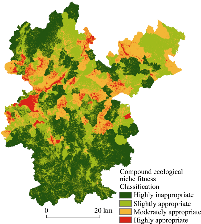
With the socio-economic development associated with urbanization, the urban-rural relationship has changed across the world. In China, due to the urban-rural dual structure, these changes turn out to be more complicated. Spatial restructuring are suggested as the main strategies and spatial supporting platforms for urban-rural development. However, the theory still lacks solid methodology and support from systematic empirical studies. This study seeks an adequate scientific methodology and discusses the difference of urban-rural transformation in plains and mountainous areas. A case in Shanghang County, China, demonstrates: 1) The compound ecological niche model can be a suitable approach in urban-rural restructuring, especially in mountainous areas. 2) The urban-rural development area with highly inappropriate, slightly appropriate, moderately appropriate, and highly appropriate areas are 1273.2 km2 (44.69%); 906.1 km2 (31.80%); 509.4 km2 (17.88%); and 160.1 km2 (5.62%), respectively. 3) The “deserting villages” in mountainous areas play positive synergistic roles in urbanization, in contrast to the “hollowing villages” common in plain areas. 4) The central town-village will become the most important settlement in mountainous areas. Therefore, we suggest more attention should be paid to environmental capacity in the construction of central town-villages. This study significantly extends the understanding of “hollowing village” theory and regional planning.
YU Zhaowu , XIAO Lishan , CHEN Xiji , HE Zhichao , GUO Qinghai , VEJRE Henrik . Spatial restructuring and land consolidation of urban-rural settlement in mountainous areas based on ecological niche perspective[J]. Journal of Geographical Sciences, 2018 , 28(2) : 131 -151 . DOI: 10.1007/s11442-018-1464-2
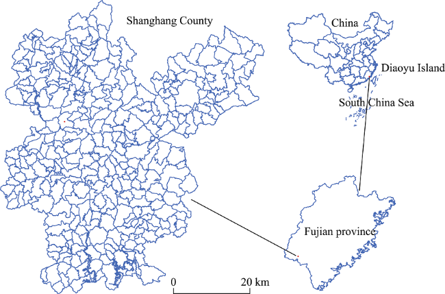
Figure 1 The study area |
Table 1 Suitability evaluation indicators and “realized” value in Shanghang County |
| Evaluation indicators | Index properties | Realized index value | Weight | Total weight | ||
|---|---|---|---|---|---|---|
| Range | Mean value | |||||
| Ecological factors | X1 | Continuity, has boundary conditions | 0-2.96 | 1.37 | 0.153 | 0.441 |
| X2 | Conceptual, no boundary conditions | — | — | 0.088 | ||
| X3 | Conceptual, no boundary conditions | — | — | 0.107 | ||
| X4 | Conceptual, has boundary conditions | — | — | 0.093 | ||
| Living factors | X5 | Continuity, no boundary conditions | 0-0.026 | 0.0013 | 0.115 | 0.354 |
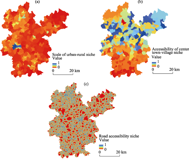
| X6 | Continuity, no boundary conditions | 0.48-8.55 | 3.71 | 0.123 | ||
| X7 | Continuity, no boundary conditions | 0-9.90 | 0.99 | 0.116 | ||
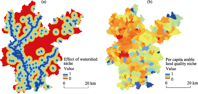
| Production factors | X8/km | Continuity, has boundary conditions | 0-14.46 | 2.83 | 0.099 | 0.205 |
| X9 | Continuity, no boundary conditions | 0-202.81 | 185.16 | 0.106 | ||
Annotation: X1: terrain niche; X2: aspect of slope; X3: soil erosion and geological disasters; X4: ecological function zone; X5: scale of town-village; X6: accessibility of central town-village; X7: road accessibility; X8: impact of watershed; X9: per capita arable land area and quality. |
Figure 2 The fitness value results of the ecological factors |
Figure 3 The fitness value results of the living factors |
Figure 4 The fitness value results of the production factors |
Table 2 The quantitative results of the aspect of slope |
| Aspect | Area proportion (%) | Fitness value | Aspect | Area proportion (%) | Fitness value |
|---|---|---|---|---|---|
| Horizontal | 0.19 | 1.00 | South | 12.76 | 1.00 |
| North | 5.97 | 0.25 | Southwest | 12.57 | 1.00 |
| Northeast | 11.80 | 0.50 | West | 13.37 | 0.75 |
| East | 12.76 | 0.75 | Northwest | 12.11 | 0.50 |
| Southeast | 12.40 | 1.00 | North | 6.05 | 0.00 |
Table 3 Soil erosion level quantitative indicator |
| Soil erosion sensitive level | Area (km2) | Area proportion (%) | Fitness value |
|---|---|---|---|
| Highly sensitive | 41.81 | 1.46 | 0.00 |
| Moderately sensitive | 1907.93 | 66.84 | 0.25 |
| Slightly sensitive | 718.03 | 25.15 | 0.50 |
| General sensitive | 187.02 | 6.55 | 0.75 |
Table 4 Geological disasters level quantitative indicator |
| Geological disasters level | Area (km2) | Area proportion (%) | Fitness value |
|---|---|---|---|
| Low risk area | 924.33 | 32.11 | 0.75 |
| Moderate risk area | 1600.81 | 55.60 | 0.50 |
| High risk area | 353.86 | 12.29 | 0.25 |
Figure 5 Classification of the urban-rural settlement lands suitability evaluation |
Table 5 The statistics of four type’s spatial restructuring area in Shanghang County |
| Types | Number of settlement | Percentage of number (%) | Area of settlement (hm2) | Percentage of area (%) | Mean area of settlement (hm2) | Shape index | AWMPFD |
|---|---|---|---|---|---|---|---|
| Priority development area | 126 | 15.52 | 1290.07 | 14.04 | 10.24 | 1.06 | 1.04 |
| Moderate development area | 188 | 23.15 | 6008.39 | 65.38 | 31.96 | 1.03 | 1.05 |
| Limited development area | 363 | 44.70 | 1309.46 | 14.25 | 3.61 | 1.31 | 1.12 |
| Migrate-regulate area | 135 | 16.63 | 518.60 | 6.33 | 4.31 | 1.57 | 1.22 |
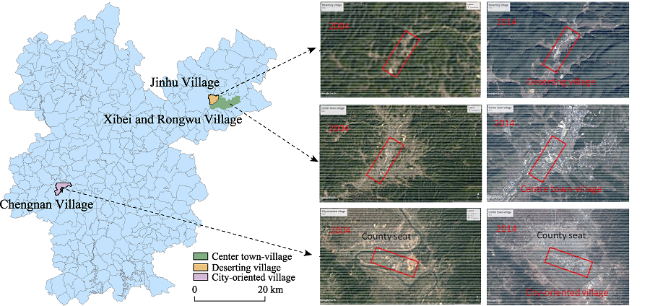
Figure 6 The images of three modes of change in rural settlements from the Google Earth |
Table 6 Landscape metrics analysis of urban-rural settlements in 2004 and 2014 |
| Year | Mean area of general settlement (hm2) | Mean area of center town- village (hm2) | Mean value of perimeter of central town-village (m) | Mean value of perimeter-area ratio of central town-village | Shape index of central town-village | AWMPFD |
|---|---|---|---|---|---|---|
| 2004 | 4.88 | 60.15 | 2576.12 | 122.71 | 1.21 | 1.06 |
| 2014 | 11.32 | 276.25 | 645080.18 | 74.01 | 1.54 | 1.07 |
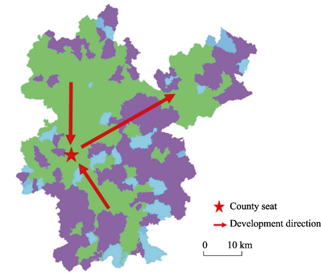
 This strategy in line with the topographic condition. The south-north direction along the Tingjiang River, which is the valley area. For the northeast direction, the areas are also rather flat than other areas in Shanghang County. This strategy in line with the development planning of Shanghang County. In the northeast of Shanghang County, we plan to build a new development area. This strategy in line with the high-speed railway planning. A high-speed railway will go through Shanghang County; one railway station (Gutian station) is in the northeast of Shanghang.
Figure 1 Urban-rural spatial restructuring and development direction in Shanghang County |
The authors have declared that no competing interests exist.
| [1] |
|
| [2] |
|
| [3] |
|
| [4] |
|
| [5] |
|
| [6] |
|
| [7] |
|
| [8] |
|
| [9] |
|
| [10] |
|
| [11] |
|
| [12] |
|
| [13] |
|
| [14] |
|
| [15] |
|
| [16] |
|
| [17] |
|
| [18] |
|
| [19] |
|
| [20] |
|
| [21] |
|
| [22] |
|
| [23] |
|
| [24] |
|
| [25] |
|
| [26] |
|
| [27] |
|
| [28] |
|
| [29] |
|
| [30] |
|
| [31] |
|
| [32] |
|
| [33] |
|
| [34] |
|
| [35] |
|
| [36] |
|
| [37] |
|
| [38] |
|
| [39] |
|
| [40] |
|
| [41] |
|
| [42] |
|
| [43] |
|
| [44] |
|
| [45] |
|
| [46] |
|
| [47] |
|
| [48] |
|
| [49] |
|
| [50] |
|
| [51] |
|
| [52] |
|
| [53] |
|
| [54] |
|
| [55] |
|
| [56] |
|
| [57] |
|
| [58] |
|
| [59] |
|
| [60] |
|
| [61] |
|
| [62] |
|
| [63] |
|
/
| 〈 |
|
〉 |
