Research Articles

Immediately downstream effects of Three Gorges Dam on channel sandbars morphodynamics between Yichang-Chenglingji Reach of the Changjiang River, China

  • WANG Jie 1 ,
  • MEI Xuefei 1 ,
  • LOU Yaying 1 ,
  • WEI Wen 1 ,
  • GE Zhenpeng 1
Expand
  • 1. State Key Laboratory of Estuarine and Coastal Research, East China Normal University, Shanghai 200062, China
  • 2. Laboratory for Marine Geology, Qingdao National Laboratory for Marine Science and Technology, Qingdao, 266061, China
*Corresponding author: Dai Zhijun, PhD and Professor, specialized in estuarine and coastal morphodynamics. E-mail:

Author: Wang Jie, Master Candidate, specialized in fluvial and estuarine morphodynamics. E-mail:

Received date: 2017-09-08

  Accepted date: 2017-12-07

  Online published: 2018-03-30

Supported by

National Natural Science Foundation of China, No.41576087

National Science Foundation for Young Scientists of China, No.41706093

Fund of the Key Laboratory of Coastal Science and Engineering, Beibu Gulf, Guangxi, No.2016ZZD01

Copyright

Journal of Geographical Sciences, All Rights Reserved

Abstract

Sandbars are of vital ecological and environmental significance, which however, have been intensively influenced by human activities. Morphodynamic processes of sandbars along the Yichang-Chenglingji Reach of the Changjiang River, the channel immediately downstream of the Three Gorges Dam (TGD), are assessed based on remote sensing images between 2000 and 2016. It can be found that the entire area of sandbars reduces drastically by 19.23% from 149.04 km2 in 2003 to 120.38 km2 in 2016, accompanied with an increase in water surface width. Owing to differences in sediment grain size and anti-erosion capacity, sandbar area in the upstream sandy gravel reach (Yichang-Dabujie) and downstream sandy reach (Dabujie-Chenglingji) respectively decreases by 45.94% (from 20.79 km2 to 11.24 km2) and 14.93% (from 128.30 km2 to 109.14 km2). Furtherly, morphological evolutions of sandbars are affected by channel type: in straight-microbend channel, mid-channel sandbars exhibit downstream moving while maintaining the basic profile; in meandering channel, point sandbars show erosion and deposition in convex and concave bank respectively, with mid-channel sandbars distributing sporadically; in bending-branching channel, point sandbars experience erosion and move downstream while mid-channel sandbars show erosion in the head part along with retreating outline. We document that the primary mechanism of sandbars shrinkages along the Yichang-Chenglingji Reach can be attributed to TGD induced suspended sediment concentration decreasing and increasing in unsaturation of sediment carrying capacity. Additionally, channel type can affect the morphological evolution of sandbars. Along the Yichang-Chenglingji Reach, sandbars in straight-microbend channel are more affected by water flow than that in bending-branching channel.

Cite this article

WANG Jie , MEI Xuefei , LOU Yaying , WEI Wen , GE Zhenpeng . Immediately downstream effects of Three Gorges Dam on channel sandbars morphodynamics between Yichang-Chenglingji Reach of the Changjiang River, China[J]. Journal of Geographical Sciences, 2018 , 28(5) : 629 -646 . DOI: 10.1007/s11442-018-1495-8

1 Introduction

A variety of alluvial sandbars are formed by riffle accumulations, floodplain avulsions, degradation of channel branches, and incision of existing bars (Knighton and Nanson, 1993; Xu, 1997; Wyrick and Klingeman, 2011), which undertake critical hydraulic and environmental functions, including stabilizing channel configurations, regulating floods and providing valuable habitats for a large number of organisms (Bridge, 1993; Ashworth et al., 2000). However, sandbars are one of the most threatened river geomorphological features as they are suffering from direct and accumulative hydrodynamic impacts (Kearsley et al., 1994; Phillips et al., 2005; Francis et al., 2010; Raška et al., 2017). Markedly, with the release of large-scale low suspended sediment concentration (SSC) flows from upstream dams, sandbars geomorphological systems can experience serious degradation in the channel immediately downstream of the dam (Petts, 1979; Friedman et al., 1998; Brandt, 2000a; Grams and Schmidt, 2005; Kleinhans et al., 2011). Understanding sandbars morphodynamics in response to water projects and the associated formation mechanisms is extremely pivotal critical and urgent for hydraulic engineering, channel regulation and fluvial management (Friedman et al., 1998; Graf, 2005; Magilligan and Nislow, 2005; Wyrick and Klingeman, 2011; Asaeda and Rashid, 2012; Dai et al., 2014; Grabowski and Gurnell, 2016).
To investigate how channel sandbars geomorphological processes respond to dam and reservoir construction, Petts (1979) reviewed potential sandbars variations subsequent to changes in discharge and bed-sediment load along multiple British rivers. Phillips et al. (2005) documented that the decreased channel slope and degradation in sandbars morphology can be attribute to the dam induced sediment supply decline with unchanged discharge regime. Raška et al. (2017) indicated that sediment starvation and erosion following the construction of dams and lock chambers caused island extinction in individual river segments. Generally, river sandbars formation and destruction are directly related with the dam induced downstream channel features variation, which have received special attentions in Britain (Petts, 1979), Australia (Erskine, 1985), New South Wales (Sherrard and Erskine, 1991), Bangladesh (Ashworth et al., 2000), American rivers (Graf, 2006; Hazel et al., 2006; Csiki and Rhoads, 2010; Skalak et al., 2013), Spain (Ibisate et al., 2013), France (Provansal et al., 2014) and Czech (Raška et al., 2017) rivers. Fluvial channel and drainage basin are critical zone of earth surface processes, especially for those immediately downstream of large dams. However, little information is available on the sandbars morphodynamics along the mega-river of Changjiang (Yangtze) River in China, which are regulated by Three Gorges Dam (TGD) since 2003, currently the world’s largest water conservancy dam.
The Changjiang River originates from the Qinghai-Tibet Plateau and flows eastward into the East China Sea, with a length more than 6300 km (Figure 1a). The catchment covers an area of over 1.8×10⁶ km2 and includes multitudinous geomorphological, vegetation and tributary types (Dai and Liu, 2013; Wei et al., 2014). Since June 2003, the TGD has trapped vast majority of sediment in its reservoir, without significantly modifying downstream flow magnitude (Dai et al., 2015). Thus coupling of drastically decreased suspended sediment concentration (SSC) and discharge (SSD) with almost unchanged water discharge produces remarkable erosion in the downstream riverbed (Yang et al., 2011; Mei et al., 2016; Dai et al., 2016). Xu and Milliman (2009) revealed that about 60% of SSD was trapped behind TGD during 2003-2006, which caused substantial erosion in the mainstream and Dongting Lake. Chang et al. (2010) estimated that the scouring amount along Jing River (Zhicheng to Chenglingji) accounts for 78.9% of that along the entire reach from Yichang to Chenglingji within 2003-2008. Luo (2012) found an abrupt longitudinal transition of sand-gravel of river bed sediment in the middle and lower Yangtze River during the post-TGD period. Meanwhile, Yuan (2012) documented that the most obvious scour occurred immediately adjacent to the TGD, due to the increased potential capacity of sediment carrying and transporting. Dai and Liu (2013) indicated that 10 years after TGD operation, channel down cutting along the thalweg throughout the river course and riverbed would be transformed from depositional before the dam construction to erosional afterwards. Yang et al. (2014) demonstrated that the alluvial and meandering channels along the mid-lower Changjiang River presented downcutting trends due to TGD impoundment. Zhang et al. (2017) showed that fluvial coarse and fine sand was restored in 2003-2014 after the construction of TGD, since river channels experienced scouring for supply new alluvial sediment.
Even though extensive studies have been carried out on the response of downstream sediment-geomorphology system to TGD induced fluvial hydrodynamic changes, few attentions are related to the evolution of sandbars morphodynamics along the Yichang-Chenglingji (YC) Reach immediately downstream of the TGD (Figure 1b). The YC Reach of the Changjiang River covers a large-scale of multiple sandbars (Figure 1b), which are sensitive to the complex changes in hydro-sediment dynamics due to the establishment of TGD. Thereafter, synthetic data of hydrology, suspended sediment and multi-remote satellite images are utilized to detect the sandbars morphodynamics along the YC Reach of the Changjiang River. The main aims of this study, therefore, are to: (1) explore the spatial-temporal characteristics of sandbars along the YC Reach; (2) discern their possible morphodynamics patterns; (3) identify the potential factors that may influence the morphodynamic processes of sandbars.

2 Research setting and methods

2.1 Study area

Immediately downstream of the TGD, YC Reach is located in the upper half of the Changjiang River’s middle reach, and it is where the river transforms from bedrock gorge to alluvial plain (Xia et al., 2016) (Figure 1a). Alluvial sandbars along the YC Reach are diversified, which can be classified as point bars and mid-channel bars, according to their developmental locations and patterns. Specifically, point bars and mid-channel bars respectively developed along the river bank and surrounded by the ambient flow, and can be converted to one another (Hooke, 1986; Birkeland, 1996; Wright and Kaplinski, 2011). According to the channel sediment composition and river shape, the YC Reach can be further divided into two sections: the upstream sandy gravel reach (Yichang-Dabujie) and the downstream sandy reach (Dabujie-Chenglingji) (Figure 1b). Specifically, the sandy gravel reach is composed of gravel sand, where the channel plane configuration and shoal landform remain basically stable (Yu and Lu, 2008; Chen et al., 2010; Xia et al., 2016). The sandy reach flows through the Jianghan and Dongting Lake alluvial plains, consisting of fine and medium sand, where channel patterns are meandering and branching with multiple point and mid-channel sandbars (Wang et al., 2009; Xia et al., 2014). The upstream sandy gravel reach mainly contains straight-microbend and bending-branching channel, while the downstream sandy reach is primarily composed by straight-microbend, meandering and bending-branching channel. The above channel patterns are classified according to the regional river regime and channel morphology from upstream to downstream. Moreover, the YC Reach discharges a fraction of water-sediment load to Dongting Lake through Songzikou, Taipingkou and Ouchikou, while obtaining water and sediment flux from the lake through Chenglingji (Figure 1b).
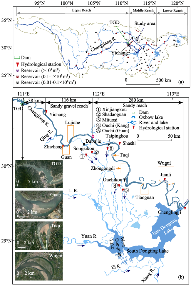
Figure 1 Map of the study area. (a) The location of Changjiang River and Yichang-Chenglingji Reach (blue box); (b) the Yichang-Chenglingji Reach. Four inserted satellite images indicate TGD and three typical sandbars are acquired from Google Earth map (http://www.google.cn/maps)

2.2 Data collection

The synthesis database of hydrology, sediment and multi-temporal Landsat satellite images can be further divided into two groups as follows:
The first group contains water discharge, SSC, flow velocity and sediment grain size measurements at Yichang, Zhicheng, Shashi and Jianli hydrologic stations (including measured and calculated values) (Figure 1b) between 1990 and 2014, covering the pre-TGD and post-TGD periods. These data were obtained from Bulletin of China River Sediment (http://www.cjw.gov.cn/).
The second group consists of remote-sensing images. Annual Landsat8 satellite images during 2000 to 2016 are acquired to examine the morphological evolution of sandbars through quantitative inversions, with occasional vacancy in 2012 and 2013 due to clouds (Table 1). Landsat images that correspond to similar water level in the dry season are selected to accurately describe the evolutions of alluvial sandbars. All available Landsat OLI (Operational Land Imager), TM (Thematic Mapper) and ETM+ (Enhanced Thematic Mapper Plus) imageries are downloaded from United States Geological Survey/Earth Resources Observation and Science Center (USGS/EROS) (https://www.usgs.gov/). A total of 16 standard Level 1 Terrain-Corrected products are obtained in this study.
Table 1 Summary of Landsat satellite products and corresponding water level (m) at four hydrologic stations
Date Sensor Yichang Zhicheng Shashi Jianli
Feb. 01, 2000 Landsat7 ETM+ 39.53 37.65 31.70 24.21
Jan. 10, 2001 Landsat5 TM 40.15 38.20 32.79 25.13
Jan. 05, 2002 Landsat7 ETM+ 39.68 38.80 32.22 24.74
Mar. 21, 2003 Landsat5 TM 38.92 37.45 31.24 25.72
Mar. 07, 2004 Landsat5 TM 40.49 38.66 32.96 25.82
Feb. 22, 2005 Landsat5 TM 38.63 37.42 30.86 26.07
Feb. 25, 2006 Landsat5 TM 40.15 38.26 32.20 25.57
Feb. 12,2007 Landsat5 TM 39.01 37.62 30.78 24.37
Feb. 15, 2008 Landsat5 TM 39.02 37.73 31.16 24.60
Jan. 16, 2009 Landsat5 TM 39.35 37.98 31.72 24.93
Feb. 20, 2010 Landsat5 TM 39.31 37.88 31.31 24.98
Jan. 06, 2011 Landsat5 TM 39.73 38.20 31.82 25.62
Jan. 14, 2014 Landsat8 OLI 39.85 38.08 31.62 25.38
Jan. 01, 2015 Landsat8 OLI 39.63 37.97 31.56 25.50
Feb. 05, 2016 Landsat8 OLI 39.99 38.16 31.34 26.30

2.3 Methods

2.3.1 Satellite image interpretation
Satellite remote sensing images and geostatistical methods have been widely adopted to explore terrain transformation analyses (Jiang et al., 2011, 2015a, 2015b; Tang et al., 2014, 2016; Messager et al., 2016). Preprocessing operations of Landsat images are all conducted via the software of Environment for Visualizing Images (ENVI), mainly through the tools of Radiometric Calibration and Fast Line-of-Sight Atmospheric Analysis of Spectral Hypercubes (FLAASH) Atmosphere Correction.
In this study, a modified normalized difference water index (MNDWI) is utilized to determine the geomorphology of mid-channel and point sandbars (Xu, 2006; Soti et al., 2009), which has been applied to identify waterbodies developments, reveal vegetation changes, environmental predictors, coastline changes and so on (Hui et al., 2008; Sun et al., 2012; Ullah et al., 2013; Tran et al., 2014; Ghosh et al., 2015). MNDWI differentiates sandbars terrestrial geomorphology from other physical features like water bodies through:
MNDWI=(Green-MIR)/(Green+MIR) (1)
where MNDWI is modified normalized difference water index, Green and MIR respectively represents a green and middle infrared band, such as TM bands 2 and 5. The MNDWI of water bodies has a higher value than other terrestrial covers like built-up land, soil and vegetation, because the spectral reflectance in the infrared wavelengths of water bodies is the lowest and significantly less than that in green band. Based on the MNDWI results and a proper threshold (distinct natural breakpoints of frequency distributions), the surface feature of the YC Reach can be categorized into sandbars and other surficial objects. Classification processes and corresponding statistics are accomplished by Esri-ArcGIS (Environment System Research Institute-Arc Geographic Information System) 10.2 software.
Once the area of total sandbars, mid-channel and point sandbars are obtained, they can be further analyzed using classified statistics technique. To study sandbars morphodynamics in detail, the YC Reach is divided into 500 subsections. For each subsection, its transverse centerline is extracted firstly, which thereafter excludes the section that covering the point and mid-channel sandbars, can be set as the subsection’s water surface width (WSW). The sum of WSW of all 500 subsections is set as total water surface width (TWSW).
2.3.2 Sediment carrying capacity
The classical theories of sediment carrying capacity (SCC) (Qian and Wan, 2003), that has been well applied to the Changjiang River by a certain of previous researchers (Yu et al., 2005; Li et al., 2011; Yuan et al., 2012), was adopted in this study to illustrate the downstream hydro-sediment processes. The related formulas are shown as follows:
where Svm is the suspended sediment carrying capacity (necessary SSC in balance); k and m are constants, in this study they are set as 0.07 and 1.14, respectively; U is water velocity; g is gravitational acceleration (9.8 m/s2); h is water depth; ω is sediment settling velocity; Sv is SSC; ω0 is setting velocity of given sediment with diameter D and density ρs (2650 kg/m3), ρw is water density (1000 kg/m3). Water velocity, water depth and SSC corresponding to various discharge scenarios for each year are calculated through power function fitting techniques. Moreover, the difference (unsaturation) between calculated Svm and measured SSC can reflect the morphodynamic condition along the downstream channel, when positive and negative value respectively indicates scour and deposition condition.
TGD starts to impound water in the June of 2003, therefore, the time series of 1990-2002 and 2003-2014 are respectively set to indicate the pre- and post-TGD stage. Note that the remote sensing image of 2003 is generated in March, which, accordingly describes the sandbars morphology in pre-TGD stage.
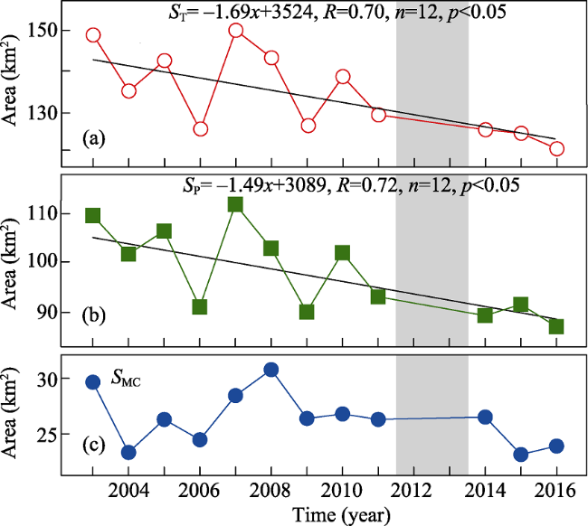
Figure 2 Temporal variation of sandbar area within Yichang-Chenglingji Reach from 2003 to 2016. (a) ST: total sandbars; (b) SMC: mid-channel sandbars; and (c) SP: point sandbars. The year with grey rectangle indicating data missing

3 Results

3.1 Changes of sandbar area between the Yichang-Chenglingji Reach

The total area of sandbars within the YC Reach decreases by 19.23% from 149.04 km2 in pre-TGD (03, 2003) to 120.38 km2 in 2016 (Figure 2a). While the point sandbars exhibits a similar observable decreasing trend in area from 109.65 km2 in 2003 to 86.49 km2 in 2016 (Figure 2b), the mid-channel sandbars only indicate a slight area decrease of 5.52 km2 over the same period (Figure 2c). Moreover, the upstream sandy gravel reach and downstream sandy reach show variant changing degrees in sandbars area. Specifically, the total sandbar area in the sandy gravel reach has a sharp decline from 20.79 km2 in 2003 to 11.24 km2 in 2016 (Figure 3a) while that in the sandy reach shows a greater erosion amount from 128.30 km2 in 2003 to 109.14 km2 in 2016 (Figure 3d). The area of mid-channel bars decreases substantially in the upstream reach but has no observable variation in the downstream reach (Figures 3b and 3e). At the same time, the area of point bars in the downstream reach exhibits a more significant decreasing trend than that of the upstream reach (Figures 3c and 3f). The multi-year average areas of total, mid-channel and point sandbars respectively decreased by 8.73%, 7.72% and 9.10% from 2000-2003 to 2004-2016 (Table 2). It needs to be stressed that the entire area of sandbars in the upstream reach only accounts for 20% of that in the downstream reach and appears a decreasing trend year by year (Figures 3a and 3d). Besides, TWSW along the entire reach, upstream sandy gravel reach and downstream sandy reach all exhibit significantly widening tendency, expending respectively by 9.29%, 9.73% and 9.10% from pre-TGD stage to 2016 (Figure 4 and Table 3). This means that the decrease of sandbar area has widened the TWSW to a certain extent.
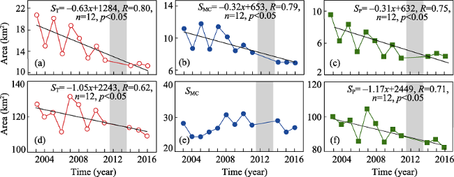
Figure 3 Temporal variation of sandbar area in (a-c) the upstream sandy gravel reach and (e-f) the downstream sandy reach, with ST, SMC, and SP respectively indicating areas of total sandbars, mid-channel sandbars and point sandbars. The year with grey rectangle indicating data missing

3.2 Geomorphological changes of sandbars along the upstream sandy gravel reach

The upstream sandy gravel reach mainly consists of two types of channel pattern, namely, bending-branching and straight-microbend channel. In this study, Guanzhou Channel and Liujiahe Channel are selected to characterize the geomorphological evolution of bending-branching and straight-microbend channels, which are respectively located 70 km and 85 km downstream of Yichang (Figure 1b).
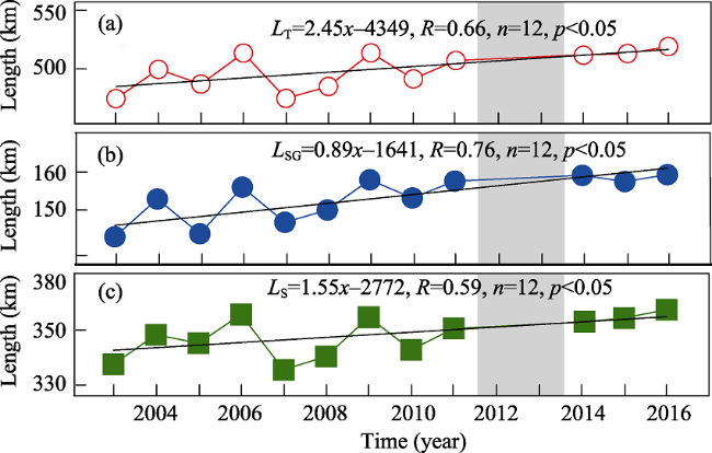
Figure 4 Temporal variation of the total water surface width (TWSW) of (a) the Yichang-Chenglingji Reach (LT); (b) the upstream sandy gravel reach (LSG); and (c) the downstream sandy reach (LS). The year with grey rectangle indicating data missing
Table 2 Summary of sandbar area variation within the Yichang-Chenglingji Reach
Area of total (km2) Area of mid-channel (km2) Area of point (km2)
Reach Whole Sandy gravel Sandy Whole Sandy gravel Sandy Whole Sandy gravel Sandy
Before TGD 145.35 20.45 126.75 38.93 10.73 26.31 106.42 10.08 100.45
After TGD 132.66 12.55 107.14 35.93 7.79 25.07 96.73 4.77 82.06
Decrease (%) 8.73 38.65 15.47 7.72 24.86 4.69 9.10 52.84 18.31

Note: pre-TGD: mean value between 2000 and 2003; post-TGD: mean value between 2004 and 2016

Table 3 Summary of channel width variation within the Yichang-Chenglingji Reach
Total reach (km) Sandy gravel reach (km) Sandy reach (km)
Before TGD 479.90 143.48 336.42
After TGD 501.51 152.98 348.53
Increase (%) 4.50 6.62 3.60

Note: Before TGD: mean value between 2000 and 2003; After TGD: mean value between 2004 and 2016

In Guanzhou Channel, the areas of sandbars, point-sandbars and mid-channel sandbars all show marked decreases from 2003 to 2013 and become stable thereafter. Specifically, point sandbars are located in the left bank of the channel with a serrated shape in 2003, which moves to the downstream thereafter and develops to an arc shape because of water erosion. In 2016, there is only a small scale of point sandbars remaining along the lower part of the left bank (Figures 5a-5d). The mid-channel sandbars appear to be spinning with an indented head in the initial stage at 2003, which move approximately 600-800 m downstream entirely in the following 14 years with its spindle contour becomes smaller. Correspondingly, the water width ratio between the left and right branch decreases from 0.92 in 2003 to 0.6 in 2016.
The straight-microbend Lujiahe Channel experiences sharp decrease in the area of sandbars, point sandbars as well as mid-channel bars during 2003-2016 (Figure 6). The channel contains a set of loosely coupled mid-channel sandbars and relatively rich point sandbars along the right bank between 2003 and 2006 (Figure 6a). In the following years from 2006-2008, the mid-channel sandbars exhibit considerable decrease both in numbers and areas (Figures 6b-6d). For instance, the area of the largest mid-channel sandbar reduces from 2.70 km2 to 1.66 km2 while a number of small mid-channel sandbars are completely disappeared. Meanwhile, the remaining mid-channel sandbars become relatively smooth owing to water erosion. Over the period of 2009-2011, the largest mid-channel sandbar turns to a slender shape while the point sandbar is further shirking (Figures 6c and 6d). In 2016, there are only two mid-channel sandbars left each with an area smaller than 0.15 km2 while the outline of the point sandbars runs almost parallel to the right bank.
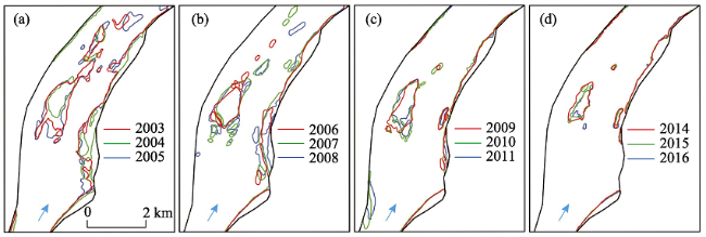
Figure 5 Sandbars geomorphological changes within Guanzhou Channel from 2003 to 2016
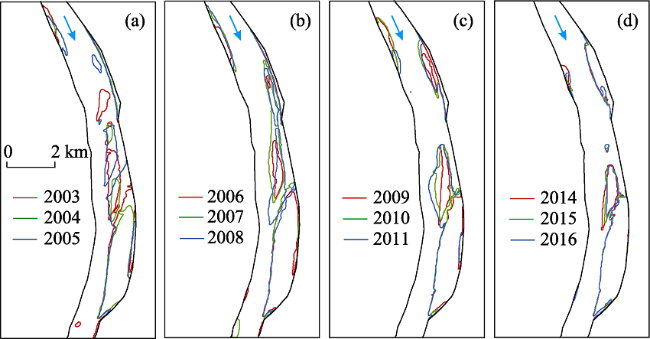
Figure 6 Sandbars geomorphological changes within Lujiahe Channel from 2003 to 2016

3.3 Geomorphological changes in sandbars along downstream sandy reach

There are three basic types of channel patterns along the downstream sandy reach: straight-microbend, meandering and bending-branching channel, which are analyzed in detail in three representative channels. Zhougongdi Channel, locating 245 km downstream of Yichang, is a typical straight-microbend channel. Sandbars along the Zhougongdi channel are made up of two mid-channel sandbars with a total area of 1.43 km2 and a fusiform point sandbar along the left bank in 2003 (Figure 7a). The two mid-channel sandbars are divided into 3-4 smaller sandbars in 2005 (Figure 7a). In the following year of 2006, there are only two mid-channel bars left, one has a small area of 0.04 km2 while the other one is adjacent to the point sandbar (Figures 7b-7d). Two line-like mid-channel sandbars appear during 2007 to 2009, which, however, disappear later in 2010 (Figures 7b-7d). Thus only a point sandbar existed in the Zhougongdi Channel since 2010.
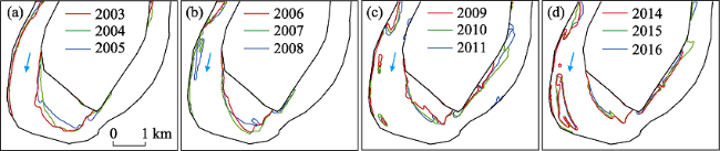
Figure 7 Geomorphological changes of sandbars within Zhougongdi Channel from 2003 to 2016
The meandering Tiaoguan Channel is located 300 km downstream of Yichang, with a large amount of point sandbars developed along its banks. The relatively large point sandbar along the convex bank suffers from extensive erosion during the past decade, with the area decreasing from 2.76 km2 in 2003 to 1.62 km2 in 2016 and the shoreline retreating 500 m (Figure 8). The long and narrow sandbar along the concave bank is relative stable during 2003-2005, followed by a considerable incision thereafter (Figure 8a). In 2008, due to the deposition of upstream sediment, there is a new mid-channel sandbar appear, with an area of 0.31 km2 (Figure 8b). Meanwhile, the point sandbars along the channel entrance gradually grow larger and continually generate small mid-channel sandbars (Figures 8c and 8d). A large scale of mid-channel sandbars is developed ultimately during 2014-2016, when, on the contrary, point sandbars continuously experiencing erosion along the concave bank. At the same time, new point sandbar is generated along the left bank of the lower reach, which develops gradually to the downstream (Figures 8c and 8d).
Jianli Channel is located 340 km downstream of Yichang, which is a typical example of bending-branching channel. At the initial stage of 2003, there are four mid-channel sand bars along the channel, with the largest Wugui Shoal covering an area of 8.87 km2. The total area of sandbars decreases from 13.14 km2 in 2003 to 11.59 km2 in 2005, when the small mid-channel sandbars are fully sourced (Figure 9a). From 2005 to 2009, a certain amount of sediment deposit along the concave bank of the channel entrance, with scared sandbars developing in terms of both mid-channel sandbars and point sandbars (Figure 9b). During this period, Wugui Shoal merges with the adjacent mid-channel sandbars, with the head developing to upstream. In the meantime, significant deposition occurs along the point sandbars that adjacent to the convex bank. In the rest 7 years from 2009 to 2016, sediment deposition continues along the left bank of the channel entrance, characterized by appearance of new sandbar (Figures 9c and 9d). While Wugui Shoal develops upstream further, the sandbars along the convex bank reaches a stable state after multiple incision and migration. Moreover, the outline of Wugui Shoal exhibits a drastic retreat of 240 m in the tail part. Small sandbars along the concave bank of the channel exit are completely eroded (Figure 9). Apparently, the channel branches develop with the evolution of mid-channel and point sandbars (Figure 9).
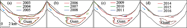
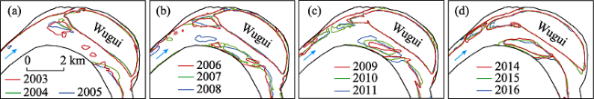
Figure 8 Geomorphological changes of sandbars within Tiaoguan Channel from 2003 to 2016
Figure 9 Geomorphological changes of sandbars within Jianli Channel from 2003 to 2016

4 Discussion

4.1 Impacts from water and suspended sediment discharge

Annual water discharges at the four stations along the YC Reach are relatively stable during 1990-2014, except the year of 2006, when an extreme drought occurs, indicating mild impacts from TGD impoundment (Figure 10a) (Yang et al., 2015; Zhao et al., 2015). Compared with those at Yichang and Zhicheng, water discharges at Shashi and Jianli are relatively small because of water diversion into Dongting Lake (Figures 10a and 1b) (Zhu et al., 2014; Li et al., 2015). However, the post-TGD SSC series show abrupt declines at all hydrometric stations, down 89.43%, 87.46%, 83.19% and 77.17%, respectively, in comparison with the pre-TGD period (Figure 10b). TGD impoundment induced sharp decreases in SSD coupled with relatively stable discharge can generate hungry (starving) water along the reach downstream of the dam, which trigger erosion of the riverbed as well as sandbars (Brandt, 2000b; Yang et al., 2011; Raška et al., 2017). The erosion tendency can be also detected in the grain size of SSD and riverbed sediment grading (Wang et al., 2009; Yang et al., 2016). For instance, in the downstream sandy reach, as the coarser sediment along the riverbed is swept to the discharge, the SSD50 at Shashi and Jianli respectively increases from 0.012 mm and 0.009 mm during 1990s-2002 to 0.024 mm and 0.059 mm during 2003-2012 (Figure 10c).

4.2 Mechanisms of sandbars morphodynamics variation

TGD regulation generates starving water along the downstream and a much smaller SSC in contrast to pre-TGD stage (Xu et al., 2013; Yang et al., 2014). In this study, Yichang hydrological station was selected to detect changes in unsaturation of sediment carrying capacities from 2003 to 2014 under different discharge scenarios, which can represent the reach that immediately downstream of the TGD because their water and sediment transport processes are similar after the impoundment of the TGD. SCC corresponding to dry (5000 m3/s), normal (10000 m3/s) and flood (20000 m3/s) scenarios are further calculated in this section. The relationships between flow discharge and flow velocity, water depth and SSC show similar fitting characteristics at different water discharge scenarios (Figure 11). It can be found that SCC respectively increases from 0.046 kg/m3 to 0.12 kg/m3 (dry scenario), from 0.17 kg/m3 to 0.32 kg/m3 (normal scenario) and from 0.90 kg/m3 to 1.00 kg/m3 (flood scenario), namely, an increase of 157%, 86% and 12% (Figures 12a-12c). Furthermore, the difference between calculated SCC and measured SSC series exhibit consistent statistical significant increase for the three scenarios (p<0.05) (Figures 12d-12f). The significant negative relationship between sandbar area and SCC shows that SCC increase is likely to decrease the sandbar area (Figure 13), indicating that sandbars within downstream channel was scoured when the measured SSC is less than calculated SCC (Brandt, 2000b; Grant et al., 2003; Phillips et al., 2005; Graf, 2006; Xiong et al., 2010; Yuan et al., 2012).
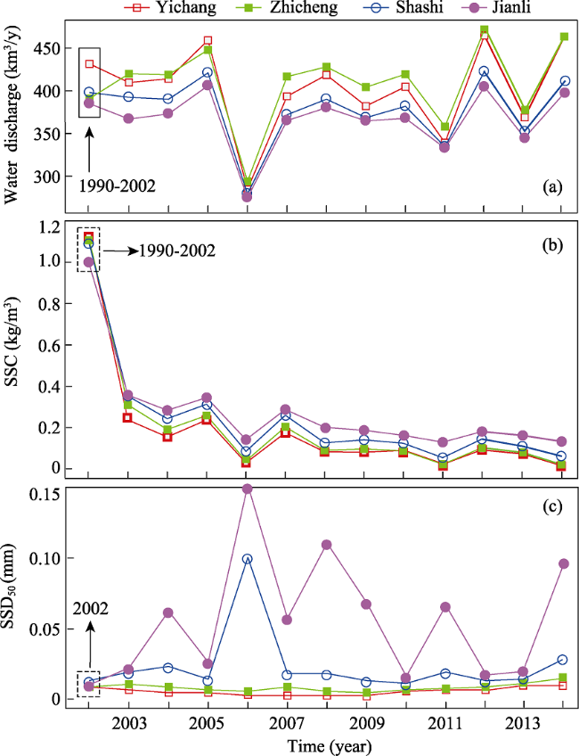
Figure 10 Temporal variation of (a) annual water discharge; (b) SSC; and (c) suspended sediment median diameter (D50) at four hydrological stations of Yichang, Zhicheng, Shashi, and Jianli
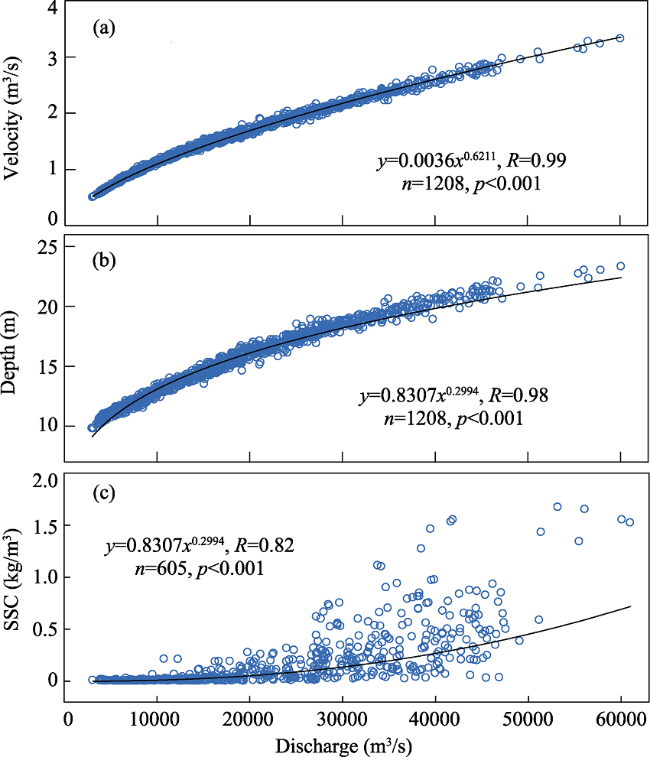
Figure 11 Relationship between flow discharge and (a) flow velocity; (b) water depth and (c) SSC
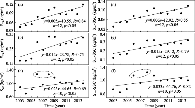
Figure 12 Temporal variation of (a-c) calculated sediment carrying capacity (Svm) and (d-e) the difference between calculated SCC and SSC (Svm-SSC) under different water discharge scenarios, with (a, d) 5000 m3/s; (b, e) 10000 m3/s; (c, f) 20000 m3/s

4.3 Impacts from multiple channel patterns

While TGD induced SCC variation causes substantial riverbed erosion along the area downstream of TGD (Yuan et al., 2012), channel morphology can also affect the morphodynamic evolution of sandbars to some extent, for establishing a new dynamic equilibrium process (Petts, 1975; Xu, 1997; Grams and Schmidt, 2005; Ibisate et al., 2013; Xia et al., 2017). In the straight-microbend channel, mid-channel sandbars suffer more severely erosion in comparison with the other types of channel because of sustained current scouring while its configuration remains basically unchanged (Figure 14a). In the meandering channel, the area of point sandbars along the convex bank decreases gradually because of hungry water erosion while its outline becomes smoother gradually. Meanwhile, the scoured sediment moves to downstream and deposits along the concave bank of the lower reach (Figure 14b). In the bending-branching channel, mid-channel sandbars indicate considerable erosion and thus retreat downstream owing to the flow branching. Point sandbars along the banks are scoured simultaneously because of current erosion (Figure 14c). Besides, riverbed sediment can affect the sandbar area to a certain degree (Sherrard and Erskine, 1991; Hazel et al., 2006; Wang et al., 2009; Brandt, 2000a; Luo et al., 2012). For example, the upstream sandy gravel reach shows a stronger anti-erosion capacity than the downstream sandy reach, and as a result, its sandbars suffer relatively weak erosion.
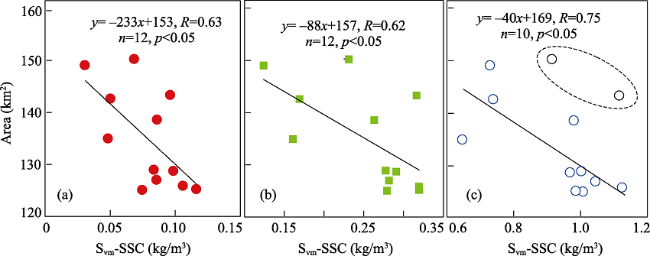
Figure 13 Relationship between sandbar area and Svm-SSC value under different water discharges scenarios: (a) 5000 m3/s; (b) 10000 m3/s; (c) 20000 m3/s
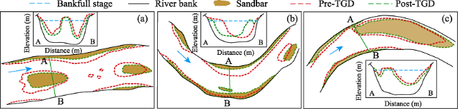
Figure 14 Evolution model of sandbars in different channel types along the Yichang-Chenglingji Reach following the impact of TGD: (a) straight-microbend channel; (b) meandering channel; and (c) bending-branching channel

5 Conclusions

River mid-channel and point sandbars provide critical and foundational functions for fluvial geomorphology and channel configuration stabilizing. However, sandbars along the Changjiang River has been significantly affected by the regulation of TGD, currently the world’s largest hydrologic engineering. Here the morphodynamics of the sandbars along the Yichang-Chenglingji Reach, immediately downstream of TGD is firstly assessed with the main conclusions shown as follows:
(1) Sandbar area along the Yichang-Chenglingji Reach decreases from 149.04 km2 in 2003 to 120.38 km2 in 2016, with the areas of point sandbars and mid-channel sandbars respectively decreases by 14.00% and 21.12%. Furtherly, sandbar area in the upstream sandy gravel reach decreases by 45.96% while that in downstream sandy reach decreases by 14.93% following the construction of TGD.
(2) Sandbars in different channel types exhibit different morphological features: mid- channel sandbars in straight-microbend channel exhibit downstream migrating, but maintain a basic profile; point sandbars in meandering channel respectively show erosion and deposition in the convex and concave banks with a certain mid-channel sandbars distributing sporadically; point sandbars in bending-branching channels experience erosion and downstream migrating while mid-channel sandbars show erosion in the head part.
(3) Three Gorges Dam induced remarkable unsaturation of sediment carrying capacity, which is the primary mechanism for sandbars scouring and shrinkage along the Yichang-Chenglingji Reach. Channel pattern can affect the geomorphological evolutions of sandbars to a certain extent, as sandbars in straight-microbend channels are more sensitive to water flow than bending-branching channels.

The authors have declared that no competing interests exist.

[1]
Asaeda T, Rashid M H, 2012. The impacts of sediment released from dams on downstream sediment bar vegetation.Journal of Hydrology, 430(8): 25-38.Sediment has been released from the dams of many rivers throughout the world to keep reservoirs operational. This huge flux of sediment resulted in deposition in downstream channels and bars and was followed by an intensive colonization of plants. An investigation was carried out to clarify the relationship between the colonization of herbaceous vegetation and a set of edaphic factors observed in downstream active river channel areas of the Kurobe River in Japan that were subject to different rates of deposition. Herbaceous plant biomass was strongly correlated (p<0.01) with surface sandy layer thickness. It had also a high correlation with a fraction of fine sediments (p<0.01). However, higher plant biomass due to fine sediment was associated with its total nitrogen (TN) concentration rather than total phosphorus (TP) or moisture content levels. The TN:TP ratio of substrate was smaller than that of the plants and suggests that the lack of nitrogen (N) was the primary factor for limiting plant growth. Following sediment release, N was no longer a limiting factor and as a result, vegetation growth was promoted. The increased depth of fine sediment in these areas also favored vegetative encroachment. Over 90% of TN and TP in the substrate were organic and originated from the nutrients that were in the sediment accumulated in the reservoir. The accumulation of sediment also changed the inundation pattern of the river channels and frequently submerged transects that were more fertile and productive for herbaceous plants as opposed to less inundated, higher spots, which represent the original unaffected portion of the river. After initial colonization, the encroachment of vegetation was accelerated by the intensified accumulation of fine sediment during inundation and added nutrients through litter mineralization. The history of sediment release in the Kurobe River and the rate of encroachment of channel vegetation follow a similar trend. The results of this study support the hypothesis that the downstream river channel morphology and ecosystem shift considerably due to multiple dam releases and create a substantial amount of sediment deposition that favorably change the nutrient stoichiometry and allow for vegetative encroachment. Therefore, any nutrient release program should consider the measurable costs and benefits when it comes to these releases and the amount of vegetative growth in these channels that result.

DOI

[2]
Ashworth P J, Best J L, Roden J Eet al., 2000. Morphological evolution and dynamics of a large, sand braid-bar, Jamuna River, Bangladesh.Sedimentology, 47(3): 533-555.

DOI

[3]
Birkeland G H, 1996. Riparian vegetation and sandbar morphology along the lower Little Colorado River, Arizona.Physical Geography, 17(6): 534-553.The distribution of riparian vegetation in relation to channel morphology is poorly understood in canyon rivers, which are characterized by in-channel fluvial sediment deposits rather than flood plains. This study focuses on vegetation and sandbar characteristics in two reaches of the lower Little Colorado River canyon in Arizonaone reach with ephemeral flow from the watershed, and another with perennial baseflow from a spring. Both reaches have been colonized by the exotic Tamarix chinensis, a riparian species known for its geomorphic influence on river channels. On the basis of a sampling of 18 bars, results show that vegetation frequency and density is significantly greater in the perennial study reach. However, sandbar morphology variables do not differ between reaches, despite a significantly narrower and deeper ephemeral channel. Hydraulic calculations of flood depths and Pearson correlations between bar and vegetation variables indicate reach-specific biogeomorphic relationships. In the ephemeral reach, higher bars are less affected by flood inundation, support older vegetation, and may be more stable habitat for vegetation. In the wider perennial reach where bars are lower and more expansive, vegetation patterns relate to bar size, Tamarix being most common on the largest bars. Overall results suggest that (1) vegetation variation relates to baseflow hydrology, (2) bar formation relates to high discharge events, and (3) vegetation patterns respond to, rather than influence, sandbar form in this canyon riparian system.

DOI

[4]
Brandt S A, 2000a. Prediction of downstream geomorphological changes after dam construction: A stream power approach.International Journal of Water Resources Development, 16(3): 343-367.A literature survey on methods of computing stable river-channel geometry, demanding a small amount of work effort and few input data, has been made and is presented. Besides the use of empirical regime equations and the use of an extremal hypothesis in conjunction with a sediment-transport and a flow-friction theory, new regression equations have been formulated which are used together with a sedimenttransport equation. These methods may prove efficient when predicting changes, such as after dam and reservoir construction, on an alluvial river. Calculations using the different methods have been exemplified on a natural river.

DOI

[5]
Brandt S A, 2000b. Classification of geomorphological effects downstream of dams.Catena, 40(4): 375-401.The effects of dams on downstream geomorphology are reviewed and a typology is devised, consisting of nine cases. The classification can be seen as a further development of Lane's balance between water discharge, sediment load, grain size, and river slope. Depending on changes in released water flow and changes in released sediment load, relative to the transport capacity of the flow, it is possible to estimate resulting cross-sectional geomorphology. The longitudinal extent of changes and their variability with time, and the tributary response to altered mainstream cross-section changes, are also discussed.

DOI

[6]
Chang J, Li J B, Lu D Qet al., 2010. The hydrological effect between Jingjiang River and Dongting Lake during the initial period of Three Gorges Project operation.Journal of Geographical Sciences, 20(5): 771-786.Based on the measured hydrological data from 1951 to 2008, the chain hydrological effect between Jingjiang River and Dongting Lake is analyzed by comparative method after the Three Gorges Project operation. The result indicates that 1) the scouring amount in Jingjiang River made up 78.9% of the total from Yichang to Chenglingji, and its average scouring intensity was higher than the latter; 2) the water and sand diversion rates at the three outlets of the Jingjiang River were reduced by 2.33% and 2.78% separately; 3) the proportion of multi-year average runoff and sediment through the three outlets in the total into the Dongting Lake decreased by 7.7% and 24.4% respectively; 4) in Dongting Lake, the speed of sediment accumulation was lowered by 26.7%, in flood season, the runoff amount was 20.2% less than the multi-year average value, leading to seasonal scarcity of water year by year. The former prolonged the lake life, while the latter induced droughts in summer and fall in successive years, shortage of drinking and industrial water, shipping insecurity, as well as ecological problems such as decrease of birds and quick increase of Microtus forUs; 5) The multi-year average values of sediment and flood transporting capacity at the lake outlet were respectively increased by 26.6% and 3.7%, the embankments were protected effectively. Then, to adapt to the new change of the river-lake relation, some suggestions were put forward, such as optimizing further operation program of the Three Gorges Reservoir, reexamining the idea of river and lake regulation, and maintaining connection of the river and the lake.

DOI

[7]
Chen Z Y, Wang Z H, Finlayson Bet al., 2010. Implications of flow control by the Three Gorges Dam on sediment and channel dynamics of the middle Yangtze (Changjiang) River, China.Geology, 38(11): 1043-1046.ABSTRACT The impacts of a dam on the river downstream in terms of hydrology and morphology are determined by a complex mix of variables that includes the patterns of release of water through the dam and the characteristics of the downstream channel. Scour of the downstream channel is a common response because large dams cause a significant interruption to sediment continuity. Here we show that in the case of China's Three Gorges Dam on the Yangtze River the outcome is complicated, as is commonly the case in large rivers. The downstream channel and floodplain system compose an area of long-term sediment accumulation and unstable channels with seasonally contrasting erosion and deposition patterns related to the migrating seasonal monsoon rainfall zones. In achieving one of the main purposes of this dam, that of flood control in the middle and lower basins, the pattern of flows released from the dam will closely resemble those seasonal flows that are responsible for channel instability in the middle catchment, thus effectively making erosive conditions the most common during a year. There is obviously concern about the ultimate impact of sediment storage in the dam on the dynamics of the delta and adjacent coast, and we show that this depends on the trajectory and duration of the erosive responses in the middle Yangtze basin. In this particular case, the outcome is of great significance to the well being of the densely populated riparian areas of the river.

DOI

[8]
Csiki S, Rhoads B L, 2010. Hydraulic and geomorphological effects of run-of-river dams.Progress in Physical Geography, 34(2): 755-780.ABSTRACT The practice of dam removal has received increasing attention as a consequence of maintenance and liability concerns related to the advanced age of many of these structures. Most dams that have been removed thus far are small run-of-river structures. As the number of removals of run-of-river dams increases, it is crucial to understand the effects that these structures have on river geomorphology and sedimentology while in place and how rivers respond to removals so that possible responses to future removals can be anticipated and predicted. This paper reviews current knowledge related to the influence of run-of-river dams on the hydraulics and geomorphology of rivers and suggests types of studies that need to be undertaken to address gaps in current knowledge. Compared to studies of large impoundment dams, field investigations of channel morphology and sedimentology upstream and downstream of run-of-river dams are few and limited in geographic scope. Available studies indicate that the response of rivers to the long-term existence of run-of-river dams is variable both in terms of upstream sediment storage and downstream channel erosion. Future research should focus on how geomorphological responses of rivers to run-of-river dams vary with geographical context and on integration of process-based field studies, numerical modeling and experimental investigations to determine the influence of these dams on flow structure, sediment transport, and patterns of channel erosion and deposition.

DOI

[9]
Dai Z J, Fagherazzi S, Mei X Fet al., 2016. Decline in suspended sediment concentration delivered by the Changjiang (Yangtze) River into the East China Sea between 1956 and 2013.Geomorphology, 268: 123-132.The temporal evolution of suspended sediment concentration (SSC) in a river debouching into the ocean provides vital insights into erosion processes in the watershed and dictates the evolution of the inner continental shelf. While the delivery of sediment from rivers to the ocean has received special attention in the recent past, few studies focused on the variability and dynamics of river SSC, especially in the Changjiang (Yangtze) river, China, the longest river in Asia. Here, variations in SSC delivered by the Changjiang River to the East China Sea and possible causes of its variability were detected based on a long-term time series of daily SSC and monthly water discharge measured at the Datong gauging station. The SSC data are further compared to a hydrological analysis of yearly precipitation covering the entire catchment. The results indicate the presence of a decline in SSC in the period 1956–2013, which can be divided into three phases: (i) high SSC (0.6902kg/m 3 ) in the wet season and low SSC (0.202kg/m 3 ) in the dry season from 1956 to 1970; (ii) relative high SSC (0.5802kg/m 3 ) in the wet season and low SSC (0.1502kg/m 3 ) in the dry season from 1971 to 2002; and (iii) low SSC (0.1902kg/m 3 ) in the wet season and very low SSC (0.0902kg/m 3 ) in the dry season after 2002. These three periods have a mean yearly SSC values of 0.62, 0.42, and 0.1802kg/m 3 , respectively. Compared with 1956–1970, the slope of the rating curve between SSC and water discharge decreased, respectively, by 2% and 30% during the period 1971–2002 and 2002–2013. Soil erosion, dam construction, and banks reinforcement along the Changjiang River are the main causes of SSC variations. Fluctuations in water discharge are also controlling the SSC long-term variations. Specifically, from 1956 to 1970, the effect of soil erosion overrules that of dam impoundment, which is likely responsible for the high SSC; during the period 1970–2002, the influence of dam impoundment increases while that of soil erosion decreases, which together produce a small reduction in SSC. Since 2002, the impact of soil erosion further decreases and large-scale sediment trapping behind the Three Gorges Dam is responsible for the occurrence of extremely low SSC. The results presented herein for the Changjiang River can inform a better management strategy of sediment resources and water quality for both the river and the coast. Our conclusions can be well applied to other rivers discharging in the ocean subject to similar human activities.

DOI

[10]
Dai Z J, Liu J T, 2013. Impacts of large dams on downstream fluvial sedimentation: An example of the Three Gorges Dam (TGD) on the Changjiang (Yangtze River).Journal of Hydrology, 480(4): 10-18.Under the influence of climate and human activities, fluvial systems have natural ability to make adjustments so that the river hydrology, sediment movement, and channel morphology are in dynamic equilibrium. Taking the Changjiang (Yangtze River) for example. In the early stages after the Three Gorges Dam (TGD) began operational ten years ago, the suspended sediment content (SSC) and fluxes in the middle and lower reaches of the river decreased noticeably. At present, they appear to be in a stable state on the decadal scale. Although the river runoff has not shown any trends, the water level in the river decreased appreciably in time. In the meantime, channel down cutting along the thalweg almost existed throughout the river course. The riverbed has turned from depositional before the dam construction to erosional afterwards. In other words, the riverbed had turned from being sediment sinks to sediment sources. In the main channel of the Changjiang between Yichang and Nanjing, a distance of 1300km, the riverbed sedimentation mode displays strong, intermediate, and weak erosion depending on the closeness to the TGD.

DOI

[11]
Dai Z J, Liu J T, Wei Wet al., 2014. Detection of the Three Gorges Dam influence on the Changjiang (Yangtze River) submerged delta.Scientific Reports, 4: 6600.While most large river-in the world are facing the risk of subsidence and in the Anthropocene, it is suspected that the Changjiang submerged () could be subjected to the impacts of the world's largest dam, the Three Gorges Dam (TGD). Here we firstly indicate that the went through high accumulation (1958-1978); slight accumulation (1978-1997), slight (1997-2002); and high accumulation (2002-2009), despite the 70% reduction of the sediment load from upstream since the operation of the TGD in 2003. Meanwhile, at the depocenter of the submerged , the accumulation maintained a high rate of 10 cm/yr during 1958-2009. This suggests on a longer term, the distal sediment source from the upstream had little effect on the . Within this time frame the changes in the partition of sediment load among the branching channels of the Changjiang Estuary could likely control the shifting of the depocenter of the on a decadal time scale. Episodic extreme floods and storm surges also increased the magnitude of deposition and of the on short-term scales. A re-evaluation of the impacts of TGD on the is urgently needed.

DOI PMID

[12]
Dai Z J, Liu J T, Xiang Y B, 2015. Human interference in the water discharge of the Changjiang (Yangtze River), china.Hydrological Sciences Journal, 60(10): 1770-1782.This study analysed 130-year-long river flow and 58-year-long meteorological records, the volume capacity of reservoirs and water consumption records over the last 60 years of the Changjiang (Yangtze River) basin. The results show that there are strong periodicities in the river discharge at seasonal, and at 3-, 7-, 11- and 14.6-year cycles. The results also show that the river discharge has decreased noticeably, and the discrepancy between flood and dry-season flows has also decreased in the last 130 years. However, the basin-wide water discharge also showed spatial and temporal variability. In the 70-year period prior to 1949, the water discharge in the middle and lower reaches of the Changjiang did not show declining trends. Between 1949 and 2011, the water discharge in the upper and middle reaches of the river showed apparent decreasing trends. Yet, because of the modulation by large lakes in the middle reaches, the water discharge to the sea did not show any noticeable changes. The primary causes of the changes in water discharge in the Changjiang basin were basin-wide dam construction and water consumption. Therefore, a regulated index (RI) is proposed to quantify human activities in the river basin. Based on RI, the Changjiang basin was weakly regulated between 1950 and 1980, intermediately regulated between 1980 and 2010, and is highly regulated at present. This is expected to worsen by 2030.

DOI

[13]
Erskine W D, 1985. Downstream geomorphic impacts of large dams: The case of Glenbawn Dam, NSW.Applied Geography, 5(3): 195-210.Downstream hydrologic effects since the closure of Glenbawn Dam, a large dual-purpose storage for water conservation and flood mitigation, include: (i) a reduction in mean annual runoff of about 21 × 10 6 m 3; (ii) a change in the probability distribution of mean daily flows involving a truncation of flows >;8 × 10 6 m 3 d 611, a much reduced frequency of flows >7 × 10 5 m 3 d 611 and an increased frequency of flows <7 × 10 5 m 3 d 611; and (iii) a reduction in flood magnitude of at least 80 per cent for all probabilities of exceedance. From suspended sediment samples collected before and after dam closure, sediment trap efficiency has been estimated at 99 per cent. An accommodation adjustment of the channel has occurred upstream of the first unregulated tributary because the bed is armoured, the banks are well vegetated, some bedrock and concrete controls are present and all regulated releases are incompetent to transport the bed material. Immediately downstream of the first unregulated tributary, the channel has contracted by up to 45 per cent and degraded by up to 69 per cent during lateral migration. Further downstream no channel changes were recorded although the bed material has progressively coarsened over time.

DOI

[14]
Francis B A, Francis L K, Cardenas M B, 2010. Water table dynamics and groundwater-surface water interaction during filling and draining of a large fluvial island due to dam-induced river stage fluctuations.Water Resources Research, 46(7): 7513.Dam-controlled river stage fluctuations alter groundwater-surface water interaction between persistent bars and islands and the rivers bounding them by rapidly changing hydraulic gradients and expanding hyporheic zones. A 300-m long and 80-m wide sand-gravel island with established vegetation located on the Colorado River (Austin, Texas, USA) is subjected to >1 m daily river stage variations due to upstream dam operations. Piezometer nests with probes monitored the evolution of the water table and groundwater flow paths through several cycles of dam-induced stage fluctuations. Results show that hydraulic head and the water table within the island closely track the river stage associated with dam release. Water table mounds and depressions which overlap in time were mapped through the course of one storage-release cycle over which >4,000 mof water moved in and out of the island. Dam operations have drastically altered groundwater-surface water connectivity between the Colorado River and the fluvial island aquifer by pumping substantial amounts of water in and out of the aquifer during dam release and storage cycles.

DOI

[15]
Friedman J M, Osterkamp W R, Scott M Let al., 1998. Downstream effects of dams on channel geometry and bottomland vegetation: Regional patterns in the Great Plains.Wetlands, 18(4): 619-633.The response of rivers and riparian forests to upstream dams shows a regional pattern related to physiographic and climatic factors that influence channel geometry. We carried out a spatial analysis of the response of channel geometry to 35 dams in the Great Plains and Central Lowlands, USA. The principal response of a braided channel to an upstream dam is channel-narrowing, and the principal response of a meandering channel is a reduction in channel migration rate. Prior to water management, braided channels were most common in the southwestern Plains where sand is abundant, whereas meandering channels were most common in the northern and eastern Plains. The dominant response to upstream dams has been channel-narrowing in the southwestern Plains (e.g., six of nine cases in the High Plains) and reduction in migration rate in the north and east (e.g., all of twelve cases in the Missouri Plateau and Western Lake Regions). Channel-narrowing is associated with a burst of establishment of native and exotic woody riparian pioneer species on the former channel bed. In contrast, reduction in channel migration rate is associated with a decrease in reproduction of woody riparian pioneers. Thus, riparian pioneer forests along large rivers in the southwestern Plains have temporarily increased following dam construction while such forests in the north and east have decreased. These patterns explain apparent contradictions in conclusions of studies that focused on single rivers or small regions and provide a framework for predicting effects of dams on large rivers in the Great Plains and elsewhere. These conclusions are valid only for large rivers. A spatial analysis of channel width along 286 streams ranging in mean annual discharge from 0.004 to 1370 cubic meters per second did not produce the same clear regional pattern, in part because the channel geometries of small and large streams are affected differently by a sandy watershed.

DOI

[16]
Ghosh M K, Kumar L, Roy C, 2015. Monitoring the coastline change of Hatiya Island in Bangladesh using remote sensing techniques.ISPRS Journal of Photogrammetry and Remote Sensing, 101(101): 137-144.A large percentage of the world population is concentrated along the coastal zones. These environmentally sensitive areas are under intense pressure from natural processes such as erosion, accretion and natural disasters as well as anthropogenic processes such as urban growth, resource development and pollution. These threats have made the coastal zone a priority for coastline monitoring programs and sustainable coastal management. This research utilizes integrated techniques of remote sensing and geographic information system (GIS) to monitor coastline changes from 1989 to 2010 at Hatiya Island, Bangladesh. In this study, satellite images from Thematic Mapper (TM) and Enhanced Thematic Mapper (ETM) were used to quantify the spatio-temporal changes that took place in the coastal zone of Hatiya Island during the specified period. The modified normalized difference water index (MNDWI) algorithm was applied to TM (1989 and 2010) and ETM (2000) images to discriminate the land-ater interface and the on-screen digitizing approach was used over the MNDWI images of 1989, 2000 and 2010 for coastline extraction. Afterwards, the extent of changes in the coastline was estimated through overlaying the digitized maps of Hatiya Island of all three years. Coastline positions were highlighted to infer the erosion/accretion sectors along the coast, and the coastline changes were calculated. The results showed that erosion was severe in the northern and western parts of the island, whereas the southern and eastern parts of the island gained land through sedimentation. Over the study period (1989-2010), this offshore island witnessed the erosion of 6476 hectares. In contrast it experienced an accretion of 9916 hectares. These erosion and accretion processes played an active role in the changes of coastline during the study period.

DOI

[17]
Grabowski R C, Gurnell A M, 2016. Hydrogeomorphology-ecology interactions in river systems.River Research and Applications, 32(2): 139-141.The European Union-funded REFORM (REstoring rivers FOR effective catchment Management) project has developed guidance and tools aimed at making river restoration and mitigation measures more effective. A major component of this work has been to investigate functional linkages between the hydrogeomorphology and ecology of rivers. This special collection presents some of the outputs from this work concerning interactions between hydrological, geomorphological and ecological processes in naturally functioning river systems. Together, this set of five papers reviews some of the existing knowledge on interactions and feedbacks between hydrogeomorphology and ecology in river systems and outlines how hydrogeomorphological processes, ecological processes and plant traits contribute to driving river corridor dynamics that create and sustain a diversity of aquatic and wetland habitats that support fish communities.

DOI

[18]
Graf W L, 2005. Geomorphology and American dams: The scientific, social, and economic context.Geomorphology, 71(1): 3-26.American geomorphologic research related to dams is embedded in a complicated context of science, policy, economics, and culture. Research into the downstream effects of large dams has progressed to the point of theory-building, but generalization and theory-building are from this research because (1) it is highly focused on a few locations, (2) it concerns mostly very large dams rather than a representative sample of sizes, (3) the available record of effects is too short to inform us on long-term changes, (4) the reversibility of changes imposed by dam installation and operation is unknown, and (5) coordinated funding for the needed research is scarce. In the scientific context, present research is embedded in a history of geomorphology in government service, with indistinct boundaries between -asic and applied- research. The federal policy that most strongly influences present geomorphological investigations connected with dams is related to habitat for endangered species, because the biological aspects of ecosystems are directly dependent on the substrate formed by the sediments and landforms that are influenced by dams. The economic context for research includes large amounts of public funds for river restoration, along with substantial private investments in dams; and geomorphology is central to these expensive issues. The cultural context for research is highly contentious and dominated by advocacy procedures that include intense scrutiny of any geomorphologic research related to dams. Advocates are likely to use the products of geomorphological research to make cases for their own positions.

DOI

[19]
Graf W L, 2006. Downstream hydrologic and geomorphic effects of large dams on American rivers.Geomorphology, 79(3): 336-360.The hydrology and geomorphology of large rivers in America reflect the pervasive influence of an extensive water control infrastructure including more than 75,000 dams. One hundred thirty-seven of the very large dams, each storing 1.2 km 3 (10 6 acre feet) of water or more, alter the flows of every large river in the country. The hydrologic effects of these very large dams emerge from an analysis of the stream gage records of 72 river reaches organized into 36 pairs. One member of each pair is an unregulated reach above a dam, whereas the other is a regulated reach downstream from the same structure. Comparison of the regulated and unregulated reaches shows that very large dams, on average, reduce annual peak discharges 67% (in some individual cases up to 90%), decrease the ratio of annual maximum/mean flow 60%, decrease the range of daily discharges 64%, increase the number of reversals in discharge by 34%, and reduce the daily rates of ramping as much as 60%. Dams alter the timing of high and low flows and change the timing of the yearly maximum and minimum flows, in some cases by as much as half a year. Regional variation in rivers, dams, and responses are substantial: rivers in the Great Plains and Ozark/Ouachita regions have annual maximum/mean flow ratios that are 7 times greater than ratios for rivers in the Pacific Northwest. At the same time, the ratio of storage capacity/mean annual water yield for dams is greatest for Interior Western, Ozark/Ouachita and Great Plains rivers and least for Pacific Northwest streams. Thus, in many cases those rivers with the highest annual variability have the greatest potential impact from dams because structures can exert substantial control over downstream hydrology. The hydrologic changes by dams have fostered dramatic geomorphic differences between regulated and unregulated reaches. When compared to similar unregulated reaches, regulated reaches have 32% larger low flow channels, 50% smaller high flow channels, 79% less active flood plain area, and 3.6 times more inactive flood plain area. Dams also affect the area of active areas, the functional surfaces that are functionally connected to the present regime of the river. Regulated reaches have active areas that are 72 smaller than the active areas of similar unregulated reaches. The geomorphic complexity (number of separate functional surfaces per unit of channel length) is 37% less in regulated reaches. Reductions in the size of hydrologically active functional surfaces are greatest in rivers in the Great Plains and least in Eastern streams. The largest differences in geomorphic complexity are in interior western rivers. The shrunken, simplified geomorphology of regulated large rivers has had direct effects on riparian ecology, producing spatially smaller, less diverse riparian ecosystems compared to the larger, more complex ecosystems along unregulated reaches of rivers.

DOI

[20]
Grams P E, Schmidt J C, 2005. Equilibrium or indeterminate? Where sediment budgets fail: Sediment mass balance and adjustment of channel form, Green River downstream from Flaming Gorge Dam, Utah and Colorado.Geomorphology, 71(1): 156-181.These findings demonstrate that sediment budgets that show a balance between inputs and outputs cannot necessarily be interpreted to indicate channel equilibrium. A sediment mass balance for 150-km reach between the dam and the first long-term gage indicates approximate balance of inputs and outputs for the pre- and post-dam periods. When uncertainty in budget components is considered, the mass balance is indeterminate. Although the Green River may have been in approximate equilibrium in the pre-dam period, we have shown that channel width is decreasing in the post-dam period. The post-dam deposits constitute a small but a significant component of the sediment budget upstream from the first major tributary. Sediment is supplied to this reach by small tributaries and, to a lesser extent, erosion of pre-dam alluvium. Downstream from the study area, the volume of the post-dam deposits is tiny relative to the volume of sediment input from the first major tributary.

DOI

[21]
Grant G E, Schmidt J C, Lewis S L, 2003. A Geological Framework for Interpreting Downstream Effects of Dams on Rivers. American Geophysical Union.Summary This chapter contains sections titled: Introduction A Geologic Framework for Interpreting Geomorphic Effects of Dams Combining Hydrogeomorphic and Geologic Controls to Predict Downstream Impacts of Dams Examples of Downstream Response to Dams: The Role of Geology Implications for Interpreting Downstream Responses to Dams: An Example from the Oregon Cascades Conclusions

DOI

[22]
Hazel J E, Topping D J, Schmidt J Cet al., 2006. Influence of a dam on fine-sediment storage in a canyon river.Journal of Geophysical Research: Earth Surface, 111(F1): 272-288.1] Glen Canyon Dam has caused a fundamental change in the distribution of fine sediment storage in the 99-km reach of the Colorado River in Marble Canyon, Grand Canyon National Park, Arizona. The two major storage sites for fine sediment (i.e., sand and finer material) in this canyon river are lateral recirculation eddies and the main-channel bed. We use a combination of methods, including direct measurement of sediment storage change, measurements of sediment flux, and comparison of the grain size of sediment found in different storage sites relative to the supply and that in transport, in order to evaluate the change in both the volume and location of sediment storage. The analysis shows that the bed of the main channel was an important storage environment for fine sediment in the predam era. In years of large seasonal accumulation, approximately 50% of the fine sediment supplied to the reach from upstream sources was stored on the main-channel bed. In contrast, sediment budgets constructed for two short-duration, high experimental releases from Glen Canyon Dam indicate that approximately 90% of the sediment discharge from the reach during each release was derived from eddy storage, rather than from sandy deposits on the main-channel bed. These results indicate that the majority of the fine sediment in Marble Canyon is now stored in eddies, even though they occupy a small percentage (17%) of the total river area. Because of a 95% reduction in the supply of fine sediment to Marble Canyon, future high releases without significant input of tributary sediment will potentially erode sediment from long-term eddy storage, resulting in continued degradation in Marble Canyon.

DOI

[23]
Hooke J M, 1986. The significance of mid-channel bars in an active meandering river.Sedimentology, 33(6): 839-850.Mid-channel bars are common on many active meandering gravel-bed rivers, but specific information on timescales of development and on the occurrence of bars is lacking. Data from the River Dane in Cheshire, NW England, are presented here which indicate that a sequence of formation from accumulations of coarse gravel on the centre of riffles through to attachment of bars to floodplains is common and takes a period of 5-15 years. The sedimentological and vegetation changes through the sequence are described and the r1e of flow events is discussed. About 10% of bends in this meandering reach contain mid-channel bars at any time. Bars develop in steeper sections of the channel and downstream of sharp corners and rapidly eroding apices. Many of the bars are caused by excessive erosion of the banks which overwidens the channel. In the longer-term the bars become incorporated in the developing meanders.

DOI

[24]
Hui F M, Xu B, Huang H Bet al., 2008. Modelling spatial-temporal change of Poyang Lake using multitemporal Landsat imagery.International Journal of Remote Sensing, 29(20): 5767-5784.Poyang Lake is a seasonal lake, exchanging water with the lower branch of the Yangtze River. During the spring and summer flooding season it inundates a large area while in the winter it shrinks considerably, creating a large tract of marshland for wild migratory birds. A better knowledge of the water coverage duration and the beginning and ending dates for the vast range of marshlands surrounding the lake is important for the measurement, modelling and management of marshland ecosystems. In addition, the abundance of a special type of snail (Oncomelania hupensis), the intermediate host of parasite schistosome (Schistosoma japonicum) in this region, is also heavily dependent on the water coverage information. However, there is no accurate digital elevation model (DEM) for the lake bottom and the inundated marshland, nor is there sufficient water level information over this area. In this study, we assess the feasibility of the use of multitemporal Landsat images for mapping the spatial‐temporal change of Poyang Lake water body and the temporal process of water inundation of marshlands. Eight cloud‐free Landsat Thematic Mapper images taken during a period of one year were used in this study. We used the normalized difference water index (NDWI) and the modified normalized difference water index (MNDWI) methods to map water bodies. We then examined the annual spatial‐temporal change of the Poyang Lake water body. Finally we attempted to obtain the duration of water inundation of marshlands based on the temporal sequence of water extent determined from the Landsat images. The results showed that although the images can be used to capture the snapshots of water coverage in this area, they are insufficient to provide accurate estimation of the spatial‐temporal process of water inundation over the marshlands through linear interpolation.

DOI

[25]
Ibisate A, Díaz E, Ollero Aet al., 2013. Channel response to multiple damming in a meandering river, middle and lower Aragón River (Spain).Hydrobiologia, 712(1): 5-23.Small hydropower plants (SHP) affect river flow and sediment transport and thus impact river morphology. Eight hydropower schemes were studied along the meandering middle and lower reaches of Aragn River (Spain) to assess their effects on channel morphology and sediment dynamics from 1927 to 2010. GIS tools were used to measure changes in fluvial surfaces, channel planform and lateral and vertical dynamics. Three periods (early, middle and late twentieth century) were analysed to discern the effects of the main pressures, such as changes in land use, large reservoirs upstream and SHPs. Results were combined with field and topographical measurements and hydrological analysis. Active channel width and channel migration suffered a clear reduction in the whole period. They started as a consequence of land cover changes in the drainage basin, but their speed increased after a large reservoir was built upstream. More recent changes occurred since most of the SHPs were put into operation in the 1990s, especially in their short-circuited reaches and in the four more downstream ones. These changes are interpreted as a consequence of reduced discharge, transitory sediment trapping and reactivation of sediment transport after weirs became filled as well as by the impact of flood hydrology.

DOI

[26]
Jiang W G, Jia K, Wu J Jet al., 2015. Evaluating the vegetation recovery in the damage area of Wenchuan Earthquake using MODIS data.Remote Sensing, 7(7): 8757-8778.The catastrophic 8.0 Richter magnitude earthquake that occurred on 12 May 2008 in Wenchuan, China caused extensive damage to vegetation due to widespread landslides and debris flows. In the past five years, the Chinese government has implemented a series of measures to restore the vegetation in the severely afflicted area. How is the vegetation recovering? It is necessary and important to evaluate the vegetation recovery effect in earthquake-stricken areas. Based on MODIS NDVI data from 2005 to 2013, the vegetation damage area was extracted by the quantified threshold detection method. The vegetation recovery rate after five years following the earthquake was evaluated with respect to counties, altitude, fault zones, earthquake intensity, soil texture and vegetation types, and assessed over time. We have proposed a new method to obtain the threshold with vegetation damage quantitatively, and have concluded that: (1) The threshold with vegetation damage was 13.47%, and 62.09% of the field points were located in the extracted damaged area; (2) The total vegetation damage area was 475,688 ha, which accounts for 14.34% of the study area and was primarily distributed in the central fault zone, the southwest mountainous areas and along rivers in the Midwest region of the study area; (3) Vegetation recovery in the damaged area was better in the northeast regions of the study area, and in the western portion of the Wenchuan-Maoxian fracture; vegetation recovery was better with increasing altitude; there is no obvious relationship between clay content in the topsoil and vegetation recovery; (4) Meadows recovered best and the worst recovery was in mixed coniferous broad-leaved forest; (5) 81,338 ha of vegetation in the damage area is currently undergoing degradation and the main vegetation types in the degradation area are coniferous forest (31.39%) and scrub (34.17%); (6) From 2009 to 2013, 41% has been restored to the level before the earthquake, 9% has not returned but 50% will continue to recover. The Chinese government usually requires five years as a period for post-disaster reconstruction. This paper could be regarded as a guidance for Chinese government departments, whereby additional investment is encouraged for vegetation recovery.

DOI

[27]
Jiang W G, Peng H, Zhu X Het al., 2011. Analysis of vegetation response to rainfall with satellite images in Dongting Lake.Journal of Geographical Sciences, 21(1): 135-149.We analyzed the Normalized Difference Vegetation Index (NDVI) from satellite images and precipitation data from meteorological stations from 1998 to 2007 in the Dongting Lake wetland watershed to better understand the eco-hydrological effect of atmospheric precipitation and its relationship with vegetation. First,we analyzed its general spatio-temporal distribution using its mean,standard deviation and linear trend. Then,we used the Empirical Orthogonal Functions (EOF) method to decompose the NDVI and precipitation data into spatial and temporal modes. We selected four leading modes based on North and Scree test rules and analyzed the synchronous seasonal and inter-annual variability between the vegetation index and precipitation,distinguishing time-lagged correlations between EOF modes with the correlative degree analysis method. According to our detailed analyses,the vegetation index and precipitation exhibit a prominent correlation in spatial distribution and seasonal variation. At the 90% confidence level,the time lag is around 110 to 140 days,which matches well with the seasonal variation.

DOI

[28]
Jiang W G, Yuan L H, Wang W Jet al., 2015. Spatio-temporal analysis of vegetation variation in the Yellow River Basin.Ecological Indicators, 51: 117-126.To understand the variation and patterns of vegetation coverage in the Yellow River Basin, as well as to promote regional ecological protection and maintain ecological construction achievements, MOD13Q1 data at a resolution of 250 m were used to calculate the annual average normalised difference vegetation index (NDVI) in a time series from 2000 to 2010. Using a variation coefficient, a Theilen Median trend analysis, the Mann-endall test, and the Hurst index method, this study investigated the temporal and spatial variations of vegetation coverage characteristics of the Yellow River Basin. The results showed that (1) the vegetation coverage of the Yellow River appeared to have an overall trend of high in the southeast and west and low in the northwest; (2) the averaged NDVI of the whole basin fluctuated in a range of 0.3 to 0.4 from 2000 to 2010 (from 2000 to 2004 there were larger variations and these have been growing rapidly since 2005); (3) the NDVI was stable, 73.4% of the vegetation-coverage area fluctuated with a low-to-medium amplitude, while 27.6% of the area varied by a large amplitude; (4) the regions with improved vegetation coverage (62.9%) were far greater than the degraded regions (27.7%), while the sustained invariant area accounted for 9.4% of the total vegetation coverage regions; and (5) 86% of the vegetation-covered area was positively sustainable. The areas with sustainable improvement accounted for 53.7% of the total vegetation coverage area; the invariant area accounted for 7.8%. The area with sustainable degradation was 24.5%; the future variation in trends of the residual (14%) could not be determined. Therefore, continuous attention must be given to the variation in trends of vegetation in the sustainably degraded and underdetermined regions.

DOI

[29]
Kearsley L H, Schmidt J C, Warren K D, 1994. Effects of Glen Canyon dam on Colorado River sand deposits used as campsites in Grand Canyon National Park, USA.River Research and Applications, 9(3): 137-149.Abstract Glen Canyon Dam, located on the Colorado River 24km upstream from Grand Canyon National Park, has affected downstream alluvial sand deposits which are used as campsites by recreational boaters. Inventories of campsite numbers and sizes conducted in 1973, 1983 and 1991, and comparison of aerial photograph series taken in 1965, 1973, 1984 and 1990 show that there has been a system-wide decrease in the number and size of campsites. Campsites are unevenly distributed along the river, and availability is regarded as ‘critical’ along reaches comprising 45% of the river, based on interviews with river guides. During the first 10 years of Glen Canyon Dam operations, at least 30% of all campsites decreased in size. During the next 18 years, between 1973 and 1991, 32% of all campsites decreased in size, and campsite capacity decreased by 44%. High annual dam releases in excess of power plant capacity in 1983 caused a net system-wide increase in the number of campsites, but decreased campsite capacity in two critical reaches. The ‘benefit’ of sand aggradation due to the 1983 high flow was short-lived, and by 1991 only a few campsites were larger than they had been in 1973. In contrast, other sites, especially in critical reaches, were eroded by the 1983 high flows and have not recovered in size. Options for future dam management must consider the variable response of campsites to high flows in critical and non-critical reaches and the duration over which ‘beneficial’ high flow effects persist.

DOI

[30]
Kleinhans M G, Berg J H V D, 2011. River channel and bar patterns explained and predicted by an empirical and a physics-based method.Earth Surface Processes and Landforms, 36(6): 721-738.Our objective is to understand general causes of different river channel patterns. In this paper we compare an empirical stream power-based classification and a physics-based bar pattern predictor. We present a careful selection of data from the literature that contains rivers with discharge and median bed particle size ranging over several orders of magnitude with various channel patterns and bar types, but no obvious eroding or aggrading tendency. Empirically a continuum is found for increasing specific stream power, here calculated with pattern-independent variables: mean annual flood, valley gradient and channel width predicted with a hydraulic geometry relation. ‘Thresholds’, above which certain patterns emerge, were identified as a function of bed sediment size. Bar theory predicts nature and presence of bars and bar mode, here converted to active braiding index (Bi). The most important variables are actual width–depth ratio and nonlinearity of bed sediment transport. Results agree reasonably well with data. Empirical predictions are somewhat better than bar theory predictions, because the bank strength is indirectly included in the empirical prediction. In combination, empirical and theoretical prediction provide partial explanations for bar and channel patterns. Increasing potential-specific stream power implies more energy to erode banks and indeed correlates to channels with high width–depth ratio. Bar theory predicts that such rivers develop more bars across the width (higher Bi). At the transition from meandering to braiding, weakly braided rivers and meandering rivers with chutes are found. Rivers with extremely low stream power and width–depth ratios hardly develop bars or dynamic meandering and may be straight or sinuous or, in case of disequilibrium sediment feed, anastomosing. Copyright 08 2010 John Wiley & Sons, Ltd.

DOI

[31]
Knighton A D, Nanson G C, 1993. Anastomosis and the continuum of channel pattern.Earth Surface Processes and Landforms, 18(7): 613-625.Anastomosing rivers are characterized by multiple channels separated by islands excised from the floodplain. Their status relative to the continuum concept of channel pattern is assessed with channel pattern defined in terms of three variables - flow strength, bank erodibility and relative sediment supply. Using an ordinal scaling (L(ow)-M(oderate)-H(igh)), the traditional forms of straight, meandering and braided have respective representations of (L,L,L), (M,L/M,L/M) and (H,H,M/H) in terms of those variables. The anastomosing pattern is on average represented by (L,L,M/H) but not so definitively as other forms. Specification of the third element (sediment supply) is particularly hampered by the paucity of data but aggradation, a characteristic of many anastomosing rivers, can be thought of as symptomatic of a moderately high rate of supply relative to the ability for onward transport. A sufficiently high rate of supply to a channel with low flow strength and resistant banks would induce shoaling and/or lateral constriction that locally forces flow out of the main channel and ultimately leads to the cutting of anabranches. A flow regime characterized by concentrated floods of relatively large magnitude is also regarded as highly conducive to the formation of new channels where low bank erodibility constrains channel capacity. Anastomosis may in certain cases represent a transitional form of channel pattern but there is no denying the longevity of some anastomosing systems.

DOI

[32]
Li Y B, 2015. Flow-sediment Transport and Riverbed Evolutions of the Middle Reaches of the Yangtze River. Beijing: China Communications Press. (in Chinese)

[33]
Li Y T, Sun S H, Deng J Y et al., 2011. Water and Sediment Control Theory and Application of Changjiang River. Beijing: Science Press. (in Chinese)

[34]
Luo X X, Yang S L, Zhang J, 2012. The impact of the Three Gorges Dam on the downstream distribution and texture of sediments along the middle and lower Yangtze River (Changjiang) and its estuary, and subsequent sediment dispersal in the East China Sea.Geomorphology, 179(1): 126-140.

DOI

[35]
Magilligan F J, Nislow K H, 2005. Changes in hydrologic regime by dams.Geomorphology, 71(1): 61-78.Dams have major impacts on river hydrology, primarily through changes in the timing, magnitude, and frequency of low and high flows, ultimately producing a hydrologic regime differing significantly from the pre-impoundment natural flow regime. This paper presents the analysis of pre- and post-dam hydrologic changes from dams that cover the spectrum of hydrologic and climatic regimes across the United States. Our overall goals are to document the type, magnitude, and direction of hydrologic shifts because of impoundment. Using the entire database for the National Inventory of Dams (NID) for dams possessing longstanding U.S. Geological Survey (USGS) gages downstream, we identified 21 gage stations that met length-of-record criteria encompassing an array of types of dams and spanning four orders of magnitude in contributing watershed area. To assess hydrologic changes associated with dams, we applied a hydrologic model, the Indicators of Hydrologic Alteration (IHA), supplemented with orientation statistics for certain hydrograph parameters. Dams had significant impacts on the entire range of hydrologic characteristics measured by IHA. For many characteristics, the direction and significance of effects were highly consistent across the 21 sites. The most significant changes across these sites occurred in minimum and maximum flows over different durations. For low flows, the 1-day through 90-day minimum flows increased significantly following impoundment. The 1-day through 7-day maximum flows decreased significantly across the sites. At monthly scales, mean flows in April and May tend to decline while mean flows in August and September increase. Other significant adjustments included changes in annual hydrograph conditions, primarily in the number of hydrograph reversals that has generally increased for almost all sites following impoundment. The number of high pulses has increased following impoundment but the average length declines. The mean rate of hydrograph rise and fall has declined significantly. These results indicate that the major pulse of dam construction during the previous century has modified hydrologic regimes on a nationwide scale, for large and small rivers.

DOI

[36]
Mei X F, Dai Z J, Fagherazzi Set al., 2016. Dramatic variations in emergent wetland area in China’s largest freshwater lake, Poyang Lake.Advances in Water Resources, 96: 1-10.Freshwater wetlands are important ecosystems experiencing rapid degradation around the world. As much as 64% of world's wetland area has been lost since 1900; the situation is even more serious in Asia, where land reclamation and anthropogenic modifications of rivers are increasing the rate of wetland disappearance. In this study, we provide a first complete estimation of daily Emergent Wetland Area (EWA) in Poyang Lake, China's largest freshwater lake, from 1955 to 2012. A wavelet analysis indicates a strong periodicity in the monthly EWA time series with two oscillations having a period of 12 and 60-72 months, respectively. A dramatic increase in mean annual EWA is detected since 2003, when the Three Gorges Dam (TGD) was completed, mainly due to the seasonal drying of 1078 km 2 of wetlands in October. It is found that the timing of wetland emergence during the dry season has been anticipated of one month, from November to October, since the establishment of TGD. It is argued that a significant increase in wetland exposure and an observable shift in the seasonal timing of flooding and drying will seriously degrade the wetland system and threaten the endangered migratory birds that inhabit it unless effective countermeasures are implemented.

DOI

[37]
Mei X F, Dai Z J, Wei Wet al., 2015. Dams induced stage-discharge relationship variations in the upper Yangtze River basin.Hydrology Research, 47(1): 157-170.Although stage–discharge relationships are crucial for discharge estimations and hydrological analyses, few efforts have been taken to assess their temporal alterations in the context of dam regulation. Here, the upper Yangtze River basin serves as an example to demonstrate the influence of hydraulic structures on stage–discharge relationships evolution. Daily records of water level and river discharge from 1950 to 2013 at Yichang hydrometric station were grouped and analyzed. Back-propagation artificial neural network was used to model the stage–discharge relationships. The obtained curves revealed substantial shifts since the Gezhouba Dam (GD) and Three Gorges Dam (TGD) were put into practice sequentially. In low flow scenarios, the decline of water levels due to GD and TGD regulation were variable with river discharge, whereas in normal flow scenarios, the rating curves indicate equilibrium state with almost the same slopes regardless of GD and TGD influence. In high flow scenarios, the rating curves representing natural condition, GD, and TGD regulation intersect with each other. Moreover, the detected changes in stage–discharge relationship were mainly in response to dam regulation, channel erosion and sand exploitation, while irrelevant to precipitation variability. The contribution of sand mining, GD regulation, and TGD regulation on rating curve variations at Yichang station were 36%, 11%, and 53%, respectively.

DOI

[38]
Messager M L, Lehner B, Grill Get al., 2016. Estimating the volume and age of water stored in global lakes using a geo-statistical approach.Nature Communications, 7: 13603.Lakes play a key role in our ecosystems and thus it is vital to understand their distribution and volume.

DOI PMID

[39]
Petts G E, 1979. Complex response of river channel morphology subsequent to reservoir construction.Progress in Physical Geography, 3(3): 329-362.Abstract Seeks to provide a unified approach to the effect of reservoir construction of river channels and to eliminate the process and feedback mechanism which effect the complex response of river channels to flow regulation. Examples of degradation, aggradation and channel metamorphoses are given, and there is a section on channel adjustment below dams. There is also a section on river responses to impoundment. The immediate response after dam construction may not reflect the final equilibrium conditions. -Keith Clayton

DOI

[40]
Phillips J D, Slattery M C, Musselman Z A, 2005. Channel adjustments of the lower Trinity River, Texas, downstream of Livingston Dam.Earth Surface Processes and Landforms, 30(11): 1419-1439.Abstract Channel cross-sectional changes since construction of Livingston Dam and Lake Livingston in 1968 were studied in the lower Trinity River, Texas, to test theoretical models of channel adjustment, and to determine controls on the spatial extent of channel response. High and average flows were not significantly modified by the dam, but sediment transport is greatly reduced. The study is treated as an opportunistic experiment to examine the effects of a reduction in sediment supply when discharge regime is unchanged. Channel scour is evident for about 60 km downstream, and the general phenomena of incision, widening, coarsening of channel sediment and a decrease in channel slope are successfully predicted, in a qualitative sense, by standard models of channel response. However, there is no consistent channel response within this reach, as various qualitatively different combinations of increases, decreases or no change in width, depth, slope and roughness occur. These multiple modes of adjustment are predicted by the unstable hydraulic geometry model. Between about 60 km and the Trinity delta 175 km downstream of the dam, no morphological response to the dam is observed. Rather than a diminution of the dam's effects on fluvial processes, this is due to a fundamental change in controls of the fluvial system. The downstream end of the scour zone corresponds to the upstream extent of channel response to Holocene sea level rise. Beyond 60 km downstream, the Trinity River is characterized by extensive sediment storage and reduced conveyance capacity, so that even after dam construction sediment supply still exceeds transport capacity. The channel bed of much of this reach is near or below sea level, so that sea level rise and backwater effects from the estuary are more important controls on the fluvial system than upstream inputs. Copyright 2005 John Wiley & Sons, Ltd.

DOI

[41]
Provansal M, Dufour S, Sabatier Fet al., 2014. The geomorphic evolution and sediment balance of the lower Rhône River (southern France) over the last 130years: Hydropower dams versus other control factors.Geomorphology, 219: 27-41.61Geomorphic changes and a 130-year sediment budget are shown for the lower Rh00ne River.61Sediment supply reduction to the river mouth over the last 130years has been drastic.61The role of dams versus other control factors on the sediment budget is analysed.61Early river navigation works and catchment changes are the main control factors.61Hydropower dams have had hardly any impact on the lower Rh00ne's sediment budget.

DOI

[42]
Qian N, Wan Z H, 2003. Mechanics of Sediment Transport. Beijing: Science Press. (in Chinese)

[43]
Raška P, Dolejš M, Hofmanová M, 2017. Effects of damming on long-term development of fluvial islands, Elbe River (N Czechia).River Research and Applications, 33(4): 471-482.Abstract Damming and water impoundment have fundamental influences on the geomorphology and ecological processes of lotic systems. Although these engineering projects affect all segments of the river channel, fluvial (mid-channel, river) islands are among the most threatened features because of their link to both hydrostatic and hydrodynamic effects of damming. In this study, we used historical maps (1843, 1852) and aerial photos (1954, 2014), as well as other written and iconographic documentary sources, to document the long-term development of the fluvial islands and channel planform in the Lower Labe (Elbe) River area (Northern Czechia) over the past ~170 years. Our results indicate the decrease of fluvial islands from 16 (1843), resp. 20 (1852) in the mid-19th century to eight in 1954, and finally to five in 2014. Most islands have disappeared because of the construction of dams and lock chambers for the purpose of river navigation in the first half of the 20th century. The possible processes responsible for island extinction in individual river segments include sediment starvation (downstream of the dam), erosion by overflow (near upstream of the dam) and decreased flow in inter-island branches (far upstream of the dam). The islands most susceptible to extinction are those with a smaller size and elliptical or irregular shape. Based on visual evaluation of historical photos and survey of present day temporary islands, the medium and fine sedimentary fraction and absence of a vegetation cover seem to be another predictor of island extinction. Finally, we stress the relevance of our findings for the current discussion on the construction of new lock chambers downstream of the study area. Copyright

DOI

[44]
Sherrard J J, Erskine W D, 1991. Complex response of a sand-bed stream to upstream impoundment.River Research and Applications, 6(1): 53-70.Mangrove Creek Dam, the eighth highest dam in NSW, Australia has induced a complex response of the downstream, sand-bed channel. Since dam closure on 1 October 1981, mean daily flows and the peak instantaneous discharge of floods have been reduced greatly (up to 94 per cent) and nearly 100 per cent of the incoming sediment load has been trapped behind the Dam. The magnitude of the hydrologic effects decreases with distance downstream. River response varies in direct proportion to the magnitude of the altered hydrologic regime and includes alternating but localized bed aggradation and degradation as well as channel contraction. Contraction has occurred by a combination of in-channel bench construction, the formation and bank attachment of longitudinal bars and bank deposition. Leptospermum polygalifolium has rapidly colonized these in-channel deposits and will result in the stabilization of benches. Armouring has not been a significant feedback process to date because of the limited degradation and low gravel supply. It is postulated that the above trends will continue, thus converting the former large, straight, active sand-bed channel into a small, sinuous, well- vegetated sand-bed stream.

DOI

[45]
Skalak K J, Benthem A J, Schenk E Ret al., 2013. Large dams and alluvial rivers in the Anthropocene: The impacts of the Garrison and Oahe Dams on the Upper Missouri River.Anthropocene, 2: 51-64.The Missouri River has had a long history of anthropogenic modification with considerable impacts on river and riparian ecology, form, and function. During the 20th century, several large dam-building efforts in the basin served the needs for irrigation, flood control, navigation, and the generation of hydroelectric power. The managed flow provided a range of uses, including recreation, fisheries, and habitat. Fifteen dams impound the main stem of the river, with hundreds more on tributaries. Though the effects of dams and reservoirs are well-documented, their impacts have been studied individually, with relatively little attention paid to their interaction along a river corridor. We examine the morphological and sedimentological changes in the Upper Missouri River between the Garrison Dam in ND (operational in 1953) and Oahe Dam in SD (operational in 1959). Through historical aerial photography, stream gage data, and cross sectional surveys, we demonstrate that the influence of the upstream dam is still a major control of river dynamics when the backwater effects of the downstream reservoir begin. In the “Anthropocene”, dams are ubiquitous on large rivers and often occur in series, similar to the Garrison Dam Segment. We propose a conceptual model of how interacting dams might affect river geomorphology, resulting in distinct and recognizable morphologic sequences that we term “Inter-Dam sequence” characteristic of major rivers in the US.

DOI

[46]
Soti V, Tran A, Bailly J Set al., 2009. Assessing optical earth observation systems for mapping and monitoring temporary ponds in arid areas.International Journal of Applied Earth Observations and Geoinformation, 11(5): 344-351.Remote sensing methods for locating and monitoring temporary ponds over large areas in arid lands were tested on a study site in Northern Senegal. Three main results are presented, validated with field data and intended to highlight different spectral, spatial and temporal characteristics of the methods: (1) Among several water indices tested, two Middle Infrared-based indices (MNDWI—Modified Normalized Difference Water Index and NDWI—Normalized Difference Water Index) are found to be most efficient; (2) an objective method is given prescribing the necessary sensor spatial resolution in terms of minimal detected pond area; and (3) the potential of multi-temporal MODIS imagery for tracking the filling phases of small ponds is illustrated. These results should assist in epidemiological studies of vector-borne diseases that develop around these ponds, but also more generally for land and water management and preservation of threatened ecosystems in arid areas.

DOI

[47]
Sun F D, Sun W X, Chen Jet al., 2012. Comparison and improvement of methods for identifying water bodies in remotely sensed imagery.International Journal of Remote Sensing, 33(21): 6854-6875.This article first examines three existing methods of delineating open water features, i.e. the normalized difference water index (NDWI), the modified normalized difference water index (MNDWI) and a method combining the near-infrared (NIR) band and the maximum likelihood classification. We then propose two new methods for the fast extraction of water features in remotely sensed imagery. Our first method is a pixel-based procedure that utilizes indices and band values. Based on their characteristic spectral reflectance curves, waterbodies are grouped into three types - clear, green and turbid. We found that the MNDWI is best suited for identifying clear water. Green water has its maximum reflectance in Landsat Thematic Mapper (TM) band 4 (NIR band), whereas turbid water has its maximum reflectance in TM band 5 (mid-infrared band). Our second method integrates our pixel-based classification with object-based image segmentation. Two Landsat scenes in Shaanxi Province, China, were used as the primary data source. Digital elevation models (DEMs) and their derived slope maps were used as ancillary information. To evaluate the performance of the proposed methods, extraction results of the three existing methods and our two new methods were compared and assessed. A manual interpretation was made and used as reference data. Results suggest that our methods, which consider the diversity of waterbodies, achieved better accuracy. Our pixel-based method achieved a producer's accuracy of 92%, user's accuracy of 90% and kappa statistics of 0.91. Our integrated method produced a higher producer's accuracy (95%), but a lower user's accuracy (72%) and kappa statistics (0.72), compared with the pixel-based method. The advantages and limitations of the proposed methods are discussed.

DOI

[48]
Tang Z H, Li R P, Li Xet al., 2014. Capturing lidar-derived hydrologic spatial parameters to evaluate playa wetlands.Jawra Journal of the American Water Resources Association, 50(1): 234-245.The digital elevation model data from traditional stereo photogrammetric methods are inadequate in providing accurate vertical parameters to feed hydrologic models for low-lying, extremely flat areas. High-resolution light detection and ranging (LiDAR) data provide the robust capability of capturing small variations in low-relief playa wetlands. The Rainwater Basin in south-central Nebraska includes a complex of seasonally shallow playa wetlands that attract millions of migratory waterfowl every spring and fall. This research focuses on the development of a procedure with applicable protocols to produce LiDAR-derived three-dimensional wetland maps and to extract the critical surface parameters (i.e., watershed boundaries, flow direction, flow accumulation, and drainage lines) for playa wetlands. The topo-hydrologic conditions of playa wetlands were evaluated at the watershed level. The results show that in the Rainwater Basin, 70.7% of the historic hydric soil footprints identified in the Soil Survey Geographic (SSURGO) database were not functioning as topographically depressional wetlands. This finding was confirmed by a recent five-year Annual Habit Survey showing that 69.8% of the historic hydric soil footprints did not function during the spring migratory bird seasons between 2004 and 2009. The majority of playa wetlands' topographic conditions have been substantially changed and the SSURGO data cannot fully reflect current topographic reality in the Rainwater Basin.

DOI

[49]
Tang Z H, Li Y, Gu Yet al., 2016. Assessing Nebraska playa wetland inundation status during 1985-2015 using Landsat data and Google Earth engine.Environmental Monitoring and Assessment, 188(12): 654.Playa wetlands in Nebraska provide globally important habitats for migratory waterfowl. Inundation condition is an important indicator of playa wetland functionality. However, there is a lack of long-

DOI PMID

[50]
Tran A, Sudre B, Paz Set al., 2014. Environmental predictors of west Nile fever risk in Europe. International Journal of Health Geographics, 13(1): 26.Background West Nile virus (WNV) is a mosquito-borne pathogen of global public health importance. Transmission of WNV is determined by abiotic and biotic factors. The objective of this study was to examine environmental variables as predictors of WNV risk in Europe and neighboring countries, considering the anomalies of remotely sensed water and vegetation indices and of temperature at the locations of West Nile fever (WNF) outbreaks reported in humans between 2002 and 2013. Methods The status of infection by WNV in relationship to environmental and climatic risk factors was analyzed at the district level using logistic regression models. Temperature, remotely sensed Normalized Difference Vegetation Index (NDVI) and Modified Normalized Difference Water Index (MNDWI) anomalies, as well as population, birds- migratory routes, and presence of wetlands were considered as explanatory variables. Results The anomalies of temperature in July, of MNDWI in early June, the presence of wetlands, the location under migratory routes, and the occurrence of a WNF outbreak the previous year were identified as risk factors. The best statistical model according to the Akaike Information Criterion was used to map WNF risk areas in 2012 and 2013. Model validations showed a good level of prediction: area under Receiver Operator Characteristic curve-=-0.854 (95% Confidence Interval 0.850-0.856) for internal validation and 0.819 (95% Confidence Interval 0.814-0.823) (2012) and 0.853 (95% Confidence Interval 0.850-0.855) (2013) for external validations, respectively. Conclusions WNF incidence is increasing in Europe and WNV is expanding into new areas where it had never been observed before. Our model can be used to direct surveillance activities and public health interventions for the upcoming WNF season.

DOI PMID

[51]
Ullah S, Skidmore A K, Groen T Aet al., 2013. Evaluation of three proposed indices for the retrieval of leaf water content from the mid-wave infrared (2-6 μm) spectra.Agricultural and Forest Meteorology, 171: 65-71.The retrieval of leaf water content based on various indices derived from the visible to shortwave infrared (0.4–2.502μm) has been frequently reported. The mid-wave infrared (2.5–6.002μm) domain has surprisingly received little attention, though the main water absorption bands are located in the mid-wave infrared. This research aimed to investigate the potential of three newly proposed narrowband indices for retrieving leaf water content from the mid-wave infrared. The proposed indices were named as Mid-wave infrared Normalized Difference Water Index (MNDWI), Mid-wave infrared Simple Ratio Water Index (MSRWI) and Mid-wave infrared Simple Difference Water Index (MSDWI). Linear relations were established between the indices (calculated from all possible two-band combinations) and leaf water content. The performance of each index was evaluated based on R 2 and RMSE. The proposed indices yielded high correlation with leaf water content, and among them MNDWI produced the most accurate model ( R 2 02=020.89 and RMSE02=027.65%) followed by MSDWI ( R 2 02=020.86 and RMSE02=028.66%) and MSRWI ( R 2 02=020.85 and RMSE02=028.86%). In conclusion, the findings of this study suggest that mid-wave infrared has the potential to retrieve leaf water content.

DOI

[52]
Wang Z Q, Chen Z Y, Li M Tet al., 2009. Variations in downstream grain-sizes to interpret sediment transport in the middle-lower Yangtze River, China: A pre-study of Three-Gorge Dam.Geomorphology, 113(3): 217-229.In 2000 and 2003 before the closure of 3-Gorges Dam, numerous sediment samples were taken from the middle-lower Yangtze River channel to examine sediment transport processes and associated hydromorphological nature of the river. Analytical results show that the riverbeds consist mostly of medium to coarse sands and gravelly sands, and fine sand occurs locally, especially near the river coast. The results further indicate a downstream fining trend in riverbed sediment from Yichang to the river mouth, totaling about 190002km long with 12 sediment zones (I-XII). These were identified as alternate coarse- and fine-grained sediment on the riverbed, although the zonation of I–III below Three-Gorges Dam site is weaker. The mode of sediment transport in the river is dominated by saltation (20–80%), followed by bed-load transport with 3–15%; transport by suspension is quite low. Grain-sizes associated with hydrological parameters have greater values in the Jingjiang Reaches (from Yichang to Chenglingji; unit stream power: 5–1802N m 61 1s 61 1, boundary shear stress: 1402Nm 61 2 and mean flow velocity: 2–3.202ms 61 1), whereas the values obtained from Chenglingji downstream are considerably low (< 502N m 61 1s 61 1, 1–402Nm 61 2 and < 0.7–1.502ms 61 1). These values, when compared with on-site measured velocity of the ADP flow column, revealed the erosive riverbed sediment transport in the Jingjiang Reaches, and the accumulative riverbed transport downstream, from Wuhan to the river coast. Hydrological parameters together with distribution of grain-sizes indicate a coarsening riverbed in the Jingjiang river, largely because damming peaked since the last half-century. This corroborates the weakening sediment zonation in the Jingjiang Reaches, which is expected to extend further downstream towards the river coast in response to the potential impact of 3-Gorges Dam in the coming decades.

DOI

[53]
Wang Z Y, 2009. Integrated Management of Hydro-sediment and Ecology in the Yangtze River Basin. Beijing: Science Press. (in Chinese)

[54]
Wei W, Chang Y P, Dai Z J, 2014. Streamflow changes of the Changjiang (Yangtze) River in the recent 60 years: Impacts of the East Asian summer monsoon, ENSO, and human activities.Quaternary International, 336(12): 98-107.Streamflow in the Changjiang River has experienced significant changes in recent decades due to the coupling of environmental factors and intensive anthropogenic activities in associated catchments. Based on a long-term data set, including water discharge, precipitation, temperature, East Asian Summer Monsoon (EASM), El Niño - Southern Oscillation (ENSO), and reservoir volumes in the most recent 60 years, the modes of streamflow changes along the Changjiang and associated factors was discussed. Analysis of streamflow observations by empirical mode decomposition show that streamflow along the Changjiang consist of a trend and four intrinsic components. Trend component in streamflow had obvious downward changes, which could be mainly attributed to dam construction. In addition, increased snowmelt caused by a warming climate led to more water being discharged into the upper reaches. The resultant intrinsic component of streamflow changes can be characterized by two modes using empirical orthogonal function analysis. The main mode represents periodic oscillations in baseflow due to the coupling of a weak EASM and weak ENSO. The secondary mode reflects differences in streamflow changes between the upper and lower reaches of the Changjiang River, which is anti-phased relative to changes in streamflow between the upper and lower reaches. These differences may be caused by a weak EASM and intensive ENSO. Moreover, the combination of a weak EASM and ENSO can lead to extreme flood. Extreme drought years may be significantly impacted by intensive EASM and ENSO.

DOI

[55]
Wright S A, Kaplinski M, 2011. Flow structures and sandbar dynamics in a canyon river during a controlled flood, Colorado River, Arizona.Journal of Geophysical Research: Atmospheres, 116(F1): 132-140.1] In canyon rivers, debris fan constrictions create rapids and downstream pools characterized by secondary flow structures that are closely linked to channel morphology. In this paper we describe detailed measurements of the three-dimensional flow structure and sandbar dynamics of two pools along the Colorado River in the Grand Canyon during a controlled flood release from Glen Canyon Dam. Results indicate that the pools are characterized by large lateral recirculation zones (eddies) resulting from flow separation downstream from the channel constrictions, as well as helical flow structures in the main channel and eddy. The lateral recirculation zones are low-velocity areas conducive to fine sediment deposition, particularly in the vicinity of the separation and reattachment points and are thus the dominant flow structures controlling sandbar dynamics. The helical flow structures also affect morphology but appear secondary in importance to the lateral eddies. During the controlled flood, sandbars in the separation and reattachment zones at both sites tended to build gradually during the rising limb and peak flow. Deposition in shallow water on the sandbars was accompanied by erosion in deeper water along the sandbar slope at the interface with the main channel. Erosion occurred via rapid mass failures as well as by gradual boundary shear stress driven processes. The flow structures and morphologic links at our study sites are similar to those identified in other river environments, in particular sharply curved meanders and channel confluences where the coexistence of lateral recirculation and helical flows has been documented.

DOI

[56]
Wyrick J R, Klingeman P C, 2011. Proposed fluvial island classification scheme and its use for river restoration.River Research and Applications, 27(7): 814-825.Abstract Fluvial islands are present in nearly all natural and regulated rivers. They are important from hydrological, biological, geopolitical and socio-economic points of view. As ubiquitous as islands are, consideration of islands is relatively absent in most river restoration concepts. The natural river processes that allow for island formation can easily be integrated into typical river classifications. To begin, an island classification scheme is proposed that can become a tool for improved river classifications and restoration projects. In developing an island classification scheme, the objectives are similar to those of previous river classification methods. By observing island characteristics, inductive generalizations may be made about the river's hydrologic and ecologic potential. In river hierarchies, the distinguishing variables used to describe streams were characteristics that could easily be discerned from their appearances, i.e. field-determinable features. A similar approach is sought for island classification. The distinguishing characteristics of any island may be sorted into three basic categories: those that can be measured from a topographic map or an aerial photograph; those that can be measured in situ at the island and those that can be inferred from either a known history of the island or from the other characteristics of the island. Once all the suitable characteristics were identified, a matrix for island classification was created which can be used to classify island origin and type. The better that the inter-relationship between island formation, channel processes and watershed processes are understood, the better the natural bio-physical regime of the river corridor can be identified and incorporated into restoration plans. Copyright 2010 John Wiley & Sons, Ltd.

DOI

[57]
Xia J Q, Deng S S, Zhou M Ret al., 2017. Geomorphic response of the Jingjiang Reach to the Three Gorges Project operation.Earth Surface Processes and Landforms, 42(6): 866-876.Upstream damming often causes significant downstream geomorphic adjustments. Remarkable channel changes have occurred in the Jingjiang Reach of the Middle Yangtze River, since the onset of the Three Gorges Project (TGP). Therefore, it is important to investigate the variations in different fluvial variables, for better understanding of the channel evolution characteristics as an example of the Jingjiang Reach. Recent geomorphic adjustments in the study reach have been investigated quantitatively, including variations in sediment rating curve, fluvial erosion intensity, channel deformation volume and bankfull channel geometry. These fluvial variables adjusted in varying degrees in response to the altered flow and sediment regime caused by the TGP operation. A focus of this study has been especially on variation in the bankfull channel geometry. Calculated bankfull dimensions at section‐ and reach‐scale indicate that: (i) there were significant bank‐erosion processes in local regions without bank‐protection engineering, with empirical relations being developed to reproduce the variation in bankfull widths at four typical sections; (ii) the variation in the reach‐scale channel geometry occurred mainly in the component of bankfull depth, owing to the construction of large‐scale bank‐revetment works, with the depth increasing from 13.765m in 2002 to 15.065m in 2014, and with an increase in the corresponding bankfull area of about 11%; and (iii) the reach‐scale bankfull channel dimensions responded to the previous 5‐year average fluvial erosion intensity during flood seasons at Zhicheng, with higher correlations for the depth and area being obtained when calibrated by the measurements in 2002–2012. Furthermore, these relations developed for the section‐ and reach‐scale bankfull channel geometry were also verified by the observed data in 2013–2014, with encouraging results being obtained. Copyright 08 2016 John Wiley & Sons, Ltd.

DOI

[58]
Xia J Q, Zong Q L, Zhang Yet al., 2014. Prediction of recent bank retreat processes at typical sections in the Jingjiang Reach after the TGP operation.Science China Technological Sciences, 57(8): 1490-1499.

DOI

[59]
Xiong M, Xu Q X, Yuan Jet al., 2010. Study of the influences of Three Gorges Project’s initial operation on river regime of the middle and lower Yangtze River.Journal of Hydroelectric Engineering, 29(1): 120-125. (in Chinese)Since the impoundment and power generation of the Three Gorges project on June 1,2003,river regime of the lower reach has experienced a great change.Up to 2006,the sediment runoffs at Yichang,Hankou and Datong are 0.0702,0.134 and 0.163 billion tons,or 86%,67% and 62% less than the mean annual values,respectively.Sediment grain size at all the hydrologic stations is coarsened,particularly at Jianli where an increase from 0.009mm to 0.150mm in grain size was observed.Meanwhile,bed erosion has been intensified significantly resulting in a lower water level.Between Yichang to Hukou where main channel erosion dominates,the erosion volume in the main channel below flood plain from Oct.2002 to Oct.2006 is 6.1410~8m~3.In comparison with 2002,the water level at Yichang after the flood season of 2006 is lowered by about 0.07m and 0.49m at flow rates 4000m~3/s and 10000m~3/s,respectively.

[60]
Xu H Q, 2006. Modification of normalised difference water index (NDWI) to enhance open water features in remotely sensed imagery.International Journal of Remote Sensing, 27(14): 3025-3033.The normalized difference water index (NDWI) of McFeeters (1996) was modified by substitution of a middle infrared band such as Landsat TM band 5 for the near infrared band used in the NDWI. The modified NDWI (MNDWI) can enhance open water features while efficiently suppressing and even removing built‐up land noise as well as vegetation and soil noise. The enhanced water information using the NDWI is often mixed with built‐up land noise and the area of extracted water is thus overestimated. Accordingly, the MNDWI is more suitable for enhancing and extracting water information for a water region with a background dominated by built‐up land areas because of its advantage in reducing and even removing built‐up land noise over the NDWI.

DOI

[61]
Xu J X, 1997. Evolution of mid-channel bars in a braided river and complex response to reservoir construction: An example from the middle Hanjiang River, China.Earth Surface Processes and Landforms, 22(10): 953-965.

DOI

[62]
Xu X B, Tan Y, Yang G S, 2013. Environmental impact assessments of the Three Gorges Project in China: Issues and interventions.Earth-science Reviews, 124(9): 115-125.The paper takes China's authoritative Environmental Impact Statement for the Yangzi (Yangtze) Three Gorges Project (TGP) in 1992 as a benchmark against which to evaluate emerging major environmental outcomes since the initial impoundment of the Three Gorges reservoir in 2003. The paper particularly examines five crucial environmental aspects and associated causal factors. The five domains include human resettlement and the carrying capacity of local environments (especially land), water quality, reservoir sedimentation and downstream riverbed erosion, soil erosion, and seismic activity and geological hazards. Lessons from the environmental impact assessments of the TGP are: (1) hydro project planning needs to take place at a broader scale, and a strategic environmental assessment at a broader scale is necessary in advance of individual environmental impact assessments; (2) national policy and planning adjustments need to react quickly to the impact changes of large projects; (3) long-term environmental monitoring systems and joint operations with other large projects in the upstream areas of a river basin should be established, and the cross-impacts of climate change on projects and possible impacts of projects on regional or local climate considered.

DOI

[63]
Xu K H, Milliman J D, 2009. Seasonal variations of sediment discharge from the Yangtze River before and after impoundment of the Three Gorges Dam.Geomorphology, 104(3): 276-283.Over the past decades, > 50,000 dams and reforestation on the Yangtze River (Changjiang) have had little impact on water discharge but have drastically altered annual and particularly seasonal sediment discharge. Before impoundment of the Three Gorges Dam (TGD) in June 2003, annual sediment discharge had decreased by 60%, and the hysteresis of seasonal rating curves in the upper reaches at Yichang station had shifted from clockwise to counterclockwise. In addition, the river channel in middle-lower reaches had changed from depositional to erosional in 2002. During the four years (2003–2006) after TGD impoundment, ~ 60% of sediment entering the Three Gorges Reservoir was trapped, primarily during the high-discharge months (June–September). Although periodic sediment deposition continues downstream of the TGD, during most months substantial erosion has occurred, supplying ~ 7002million tons per year (Mt/y) of channel-derived sediment to the lower reaches of the river. If sand extraction (~ 4002Mt/y) is taken into consideration, the river channel loses a total of 11002Mt/y. During the extreme drought year 2006, sediment discharge in the upper reaches drastically decreased to 902Mt (only 2% of its 1950–1960s level) because of decreased water discharge and TGD trapping. In addition, Dongting Lake in the middle reaches, for the first time, changed from trapping net sediment from the mainstem to supplying 1402Mt net sediment to the mainstem. Severe channel erosion and drastic sediment decline have put considerable pressure on the Yangtze coastal areas and East China Sea.

DOI

[64]
Yang S L, Milliman J D, Li Pet al., 2011. 50000 dams later: Erosion of the Yangtze River and its delta.Global and Planetary Change, 75(1): 14-20.Using 50 years of hydrologic and bathymetric data, we show that construction of ~ 50,000 dams throughout the Yangtze River watershed, particularly the 2003 closing of the Three Gorges Dam (TGD), has resulted in downstream channel erosion and coarsening of bottom sediment, and erosion of the Yangtze's subaqueous delta. The downstream channel from TGD reverted from an accretion rate of ~ 90 Mt (1Mt = 1000 000 t)/yr between the mid-1950 s and mid-1980 s to an erosion rate of ~ 60 Mt/yr after closing of the TGD. The delta front has devolved from ~ 125 Mm 3 (1 Mm 3 = 1000 000 m 3)/yr of sediment accumulation in the 1960 s and 1970 s, when river sediment load exceeded 450 Mt/yr, to perhaps 100 Mm 3/yr of erosion in recent years. As of 2007 erosion seemed to have been primarily centered at 5-8 m water depths; shallower areas remained relatively stable, perhaps in part due to sediment input from eroding deltaic islands. In the coming decades the Yangtze's sediment load will probably continue to decrease, and its middle-lower river channel and delta will continue to erode as new dams are built, and the South-to-North Water Diversion is begun.

DOI

[65]
Yang S L, Milliman J D, Xu K Het al., 2014. Downstream sedimentary and geomorphic impacts of the Three Gorges Dam on the Yangtze River.Earth-Science Reviews, 138: 469-486.Although large dams have been constructed and continue to be constructed on many rivers, the lack of long-term gauging data often makes it difficult to document either reservoir sedimentation or the dams' downstream impacts. More than 50years of water and sediment data from 20 gauging stations within the Yangtze River's basin provide us a unique opportunity to delineate the impacts from the Three Gorges Dam (TGD), the world's largest dam. During the first decade after TGD completion in 2003, 1.8Gt of sediments were trapped in the Three Gorges Reservoir (TGR). The TGR's sediment retention rate increased from ~65% during the first three years of operation to ~85% by 2008-2012, when the TGD was in normal operation; in the low-discharge drought years of 2006 and 2011, reservoir retention exceeded 90%. Sedimentation in the TGR has been discontinuous, the most prominent depocenters being at the broad section near the up-river entrance to the reservoir and just upstream of the dam, where sediment thickness locally exceeds 60m. Median size of the sediments trapped in the TGR is 11 m, whereas sediments discharged from the TGR are finer than 5 m. As a result of sediment retention in the TGR, the river downstream has been eroded at a rate of 65Mt/yr. Riverbed sediments have coarsened considerably in the first several hundred kilometers downstream of TGD. Sediment discharge into the Yangtze estuary, as measured at the Datong downstream gauging station, decreased by 130Mt/yr relative to the normal water years of 2001-2002, nearly 90% of which can be attributed to the TGD. With planned construction of large upstream Cascade Reservoirs, the amount of sediment entering the TGR will decline dramatically, thus reducing sedimentation in the TGR and thereby extending its lifespan; by the end of the 21st century, the TGR should have retained more than 80% of its original storage capacity. Sediment outflow from the TGR will likely be less than 15Mt/yr, compared to 50Mt/yr at present. Even with downstream channel erosion, the long-term average sediment discharge into the Yangtze estuary in future decades most likely will decrease to ca. 110Mt/yr, only 20% of its level in the 1960s, and further delta erosion is expected.

DOI

[66]
Yang S L, Xu K H, Milliman J Det al., 2015. Decline of Yangtze River water and sediment discharge: Impact from natural and anthropogenic changes.Scientific Reports, 5: 12581.The increasing impact of both climatic change and human activities on global river systems necessitates an increasing need to identify and quantify the various drivers and their impacts on fluvial water and sediment discharge.

DOI PMID

[67]
Yang Y P, Zhang M J, Li Y Tet al., 2016. Suspended sediment recovery and bedsand compensation mechanism affected by the Three Gorges Project.Acta Geographica Sinica, 71(7): 1241-1254. (in Chinese)Construction of basin reservoir projects can change the water and sediment transport processes in the lower reaches. The effects of the Three Gorges Project(TGP) on water and sediment transport in lower reaches are emerging. Specifically:(1) The duration and volume of floods in the lower reaches of TGP declined sharply. The sediment value was of such a low concentration that the water was nearly clear. The suspended sediment discharge gradually recovered downwards but its total amount still could not outcompete the annual average of that before the impoundment of TGP.(2) The sediment with d 0.125 mm recovered to some extent in 2003- 2014(more in 2003- 2007 than in 2008- 2014) and basically recovered to the average value before the impoundment at the Jianli Station. After recovery, its transport trend in the lower reaches was in line with that before the impoundment.(3) After the impoundment,sediment with d 0.125 mm recovered to some extent but its total amount was still less than the average of before the impoundment.(4) The recovery of sediment with d 0.125 mm was mainly from river- bed erosion but with an amount not exceeding 44 million t/y which was primarily limited by duration and average flow of floods and secondarily by the upper mainstream, tributaries between river sections and the sub- sink effects of lakes. Recovery of the suspended sediment with d 0.125 mm was controlled by the upper mainstream, tributaries between river sections, the sub- sinks of lakes and river- bed compensation. The suspended sediment compensation from river- bed decreased due to the coarsening of bedsands.(4) In2003- 2007 and 2008- 2014, both coarse and fine sands were eroded in the Yichang- Zhicheng section in the upper Jingjiang River while coarse sands deposited and fine sands eroded in the lower Jingjiang River. In the Hankou- Datong section, coarse sands deposited and fine sands eroded. From 2003 to 2007, coarse sands deposited while fine sands eroded in the ChenglingjiHankou section. In 2008- 2014, both coarse and fine sands eroded in the Chenglingji- Hankou section. The differences were caused by the duration and volume of the floods in the Luoshan Station.

DOI

[68]
Yu W C, Lu J Y, 2005. River Channel Evolution and Governance of Changjiang River. Beijing: China Water Power Press. (in Chinese)

[69]
Yu W C, Lu J Y, 2008. Bank Erosion and Protection in the Yangtze River. Beijing: China Water and Power Press. (in Chinese)

[70]
Yuan W H, Yin D W, Finlayson Bet al., 2012. Assessing the potential for change in the middle Yangtze River channel following impoundment of the Three Gorges Dam.Geomorphology, 147(8): 27-34.The geomorphic impacts of dams on downstream river channels are complex, not readily predictable for specific cases, but widely reported in the literature. For the Three Gorges Dam on the Yangtze (Changjiang) River in China, no studies of the impact of the changed flow and sediment conditions below the dam on the behaviour of the channel were included in the pre-dam feasibility report. We have assembled a database of flow and sediment data for the middle Yangtze River from Yichang to Hankou and used this to analyse changes following the closure of the dam. While total flow is little affected, the operating strategy for the dam that provides for storage of part of the summer high flows to maintain hydroelectric power generation in winter (the low flow season) is reflected in changes to the seasonal distribution of flow below the dam. We calculated potential sediment carrying capacity and compared it with measured sediment concentrations for both pre- and post-dam conditions. While channel sedimentation is indicated along the middle Yangtze for pre-dam conditions, scour is indicated for post-dam conditions, highest at Yichang immediately below the dam and decreasing downstream.

DOI

[71]
Zhang W, Yang Y P, Zhang M Jet al., 2017. Mechanisms of suspended sediment restoration and bed level compensation in downstream reaches of the Three Gorges Projects (TGP).Journal of Geographical Sciences, 27(4): 463-480.River basin reservoir construction affects water and sediment transport processes in downstream reaches. The downstream impact of the Three Gorges Projects (TGP) has started to become apparent: (1) reduction in flood duration and discharge, and significant reduction in sediment load. Although there was some restoration in downstream sediment load, the total amount did not exceed the pre-impoundment annual average; (2) in 2003–2014, the d > 0.125 mm (coarse sand) load was restored to some degree, and to a maximum at Jianli Station, which was mainly at the pre-impoundment average. After restoration, erosion and deposition characteristics of the sediment was identical to that before impoundment. The degree of restoration during 2008–2014 was less than during 2003–2007; (3) after TGP impoundment, there was some restoration in d 0.125 mm sediment load recovered to a certain degree after impoundment, however, the total did not exceed 4400×10 4 t/y. This was mainly limited by flood duration and the average flow rate, and was less affected by upstream main stream, tributaries, or lakes. Restoration of d < 0.125 mm suspended sediment was largely controlled by upstream main stream, tributaries, and lakes, as well as by riverbed compensation. Due to bed armoring, riverbed fine suspended sediment compensation capability was weakened; (5) during 2003–2007 and 2008–2014, Yichang to Zhicheng and upper Jingjiang experienced coarse and fine erosion, lower Jingjiang experienced coarse deposition and fine erosion, Hankou to Datong had coarse deposition and fine erosion, and Chenglingji and Hankou was characterized by coarse deposition and fine sand erosion in 2003–2007, and coarse and fine erosion in 2008–2014. This difference was controlled by flood duration and number at Luoshan Station.

DOI

[72]
Zhao Y F, Zou X Q, Gao J Het al., 2015. Quantifying the anthropogenic and climatic contributions to changes in water discharge and sediment load into the sea: A case study of the Yangtze River, China.Science of the Total Environment, 536: 803-812.Based on data from the Datong hydrological station and 147 meteorological stations, the influences of climate change and human activities on temporal changes in water discharge and sediment load were examined in the Yangtze River basin from 1953 to 2010. The Mann–Kendall test, abrupt change test (Mann–Kendall and cumulative anomaly test), and Morlet wavelet method were employed to analyze the water discharge and sediment load data measured at the Datong hydrological station. The results indicated that the annual mean precipitation and water discharge exhibited decreasing trends of 61020.006402mm/1002yr and 61021.4102×0210 8 02m 3 /yr, respectively, and that the water sediment load showed a significant decreasing trend of 610246.502×0210 6 02t/yr. Meanwhile, an abrupt change in the water discharge occurred in 2003. The sediment load also exhibited an abrupt change in 1985. From 1970 to 2010, the climate change and human activities contributed 72% and 28%, respectively, to the water discharge reduction. The human-induced decrease in the sediment load was 914.0302×0210 6 02t/yr during the 1970s and 3301.7902×0210 6 02t/yr during the 2000s. The contribution from human activities also increased from 71% to 92%, especially in the 1990s, when the value increased to 92%. Climate change and human activities contributed 14% and 86%, respectively, to the sediment load reduction. Inter-annual variations in water discharge and sediment load were affected by climate oscillations and human activities. The effect of human activities on the sediment load was considerably greater than those on water discharge in the Yangtze River basin.

DOI PMID

[73]
Zhu L L, Chen J C, Yuan Jet al., 2014. Sediment erosion and deposition in two lakes connected with the middle Yangtze River and the impact of Three Gorges Dam.Advances in Water Science, 25(3): 348-357. (in Chinese)As the largest freshwater lakes in China,the Poyang and Dongting Lakes enter a complicate coupling with the middle reach of Yangtze River,which plays a significant role in flood control and eco-environment protection. Based on the field flow-sediment and topography data,the leading factors to the characteristics of sediment erosion and deposition in both Lakes have been studied,of which the Three Gorges Reservoir is highlighted. The results indicate that the rate of siltation in both Lakes shows visibly slowdown to occasional erosion in the recent decade. The decrease of sedimentation rate in Dongting Lake is basically induced by the reduction of incoming sediment due to the operation of Three Gorges Reservoir,while the erosion dominated in Hukou reach of Poyang Lake is mainly caused by excessive sand mining rather than the Three Gorges Reservoir which still remains uncertain.

DOI

Outlines

/