Research Articles

Understanding spatial structures and organizational patterns of city networks in China: A highway passenger flow perspective

  • CHEN Wei , 1, 2, 3 ,
  • Liu Weidong , 1, 2 ,
  • KE Wenqian 4 ,
  • WANG Nyuying 5
Expand

Author: Chen Wei (1989-), PhD Candidate, specialized in economic geography and regional development. E-mail:

*Corresponding author: Liu Weidong (1967-), PhD and Professor, specialized in economic geography and regional development. E-mail:

Received date: 2017-05-23

  Accepted date: 2017-06-26

  Online published: 2018-03-30

Supported by

National Natural Science Foundation of China, No.41530751, No.41471113, No.41601165

Copyright

Journal of Geographical Sciences, All Rights Reserved

Abstract

The use of multi-perspective and multi-scalar city networks has gradually developed into a range of critical approaches to understand spatial interactions and linkages. In particular, road linkages represent key characteristics of spatial dependence and distance decay, and are of great significance in depicting spatial relationships at the regional scale. Therefore, based on highway passenger flow data between prefecture-level administrative units, this paper attempted to identify the functional structures and regional impacts of city networks in China, and to further explore the spatial organization patterns of the existing functional regions, aiming to deepen our understanding of city network structures and to provide new cognitive perspectives for ongoing research. The research results lead to four key conclusions. First, city networks that are based on highway flows exhibit strong spatial dependence and hierarchical characteristics, to a large extent spatially coupled with the distributions of major megaregions in China. These phenomena are a reflection of spatial relationships at regional scales as well as core-periphery structure. Second, 19 communities that belong to an important type of spatial configuration are identified through community detection algorithm, and we suggest they are correspondingly urban economic regions within urban China. Their spatial metaphors include the administrative region economy, spatial spillover effects of megaregions, and core-periphery structure. Third, each community possesses a specific city network system and exhibits strong spatial dependence and various spatial organization patterns. Regional patterns have emerged as the result of multi-level, dynamic, and networked characteristics. Fourth, adopting a morphology-based perspective, the regional city network systems can be basically divided into monocentric, dual-nuclei, polycentric, and low-level equilibration spatial structures, while most are developing monocentrically.

Cite this article

CHEN Wei , Liu Weidong , KE Wenqian , WANG Nyuying . Understanding spatial structures and organizational patterns of city networks in China: A highway passenger flow perspective[J]. Journal of Geographical Sciences, 2018 , 28(4) : 477 -494 . DOI: 10.1007/s11442-018-1485-x

1 Introduction

Towards the end of the second millennium of the Christian era, in concert with the deepening processes of globalization and digitalization, massive developments in information technology, telecommunications, and modern transportation led to dramatic regional economic revolutions (Taylor et al., 2002; Castells, 2010). Data show that both growth in production and spatial organization follow a diversified trend, while a transformation took place that led to contemporary regional economies being gradually dominated by functional networked space rather than hierarchal space based on administrative units (Liu and Zhen, 2004). Thus, alongside the “space of flows”, cities have become increasingly involved in the diversified flows of global production factors. The study of city networks, as examples of flow systems, has emerged as a consequence of this background. As a new type of spatial organization that originated in the age of globalization and information, city network refers to horizontal and non-hierarchical relational geographies between similar or complementary cities and emphasizes specialized division of labor and externality (Camagni and Capello, 2004). In current research, hierarchical structures have long provided the traditional perspective underlying understanding of urban systems. However, in the contemporary context of urban geography, more attention has been placed on the structure, function, and relationships of city networks within multi-scalar spaces (Taylor et al., 2010).
Inspired by the “space of flows” theory (Castells, 1996), a new research agenda has developed within urban studies that emphasizes relational geography. In this context, research on multi-level and multi-scalar city networks has substantially enriched our understanding of both spatial logic and regional cognition. These approaches have even led to breakthroughs and innovations in methods and theory. Thus, at present, research on city network can be broadly divided into two main schools including “world city network” (Taylor et al., 2001) and “polycentric urban region” (Hall and Pain, 2006) that are focused respectively at either global (or national) or regional scales (Malecki, 2002; Hoyler et al., 2008; Taylor et al., 2009). In empirical studies, measurements of city networks at different spatial scales have mainly been conducted using infrastructural networks (Alderson and Beckfield, 2004; Derudder and Witlox, 2008), enterprise organizations (Beaverstock and Smith, 1996; Taylor et al., 2009), or social culture relationships (Taylor, 2004).
Compared to other approaches, the use of infrastructural networks appears most efficient. This approach can be subdivided into two categories, the first of which deals with transport infrastructure, including the intercity passenger and cargo flows of air, railway and so on, as representative of the linkages between cities. The second category is communication infrastructure, specifically the use of the Internet, telephone communications, and postal service flows to describe city network structures. Research on Chinese city networks has flourished in recent years, characterized by emphasis on transport infrastructure (Yu et al., 2008; Zhong and Lu, 2011), the organization of enterprise (Derudder et al., 2010; Zhao et al., 2015), and Internet communication (Dong et al., 2014; Zhen et al., 2016). As a consequence, the research methods in this field tend to employ social and complex networks to calculate topological properties, which contribute to the extraction of city network structural features. Previous studies, however, have more or less ignored the influence of geographical space and have not incorporated a comprehensive understanding of the internal logic of city networks.
City networks can be mapped using intercity relationships, which to some extent are affected by city hierarchy, geographical distance, and their spatial interactions (Chen et al., 2015). These factors mean that high-ranking cities have tended to overcome the constraints of geographical distance and achieve frequent intercity factor flows. Because the strength of these flows decays as geographical distance increases, it is worthwhile to investigate the interactions between city hierarchy and city network development, as well as the role played by geographical distance in this process. Interregional flows of passengers and goods are important indexes used to effectively reflect city networks as they are naturally sensitive to geographical distance. However, because of data acquisition limits, contemporary research on city network from the perspective of traffic infrastructure has mainly utilized flow data of airway and railway. Research on highway flows has mostly been conducted relatively recently and so limited attention has been given to city networks and regional interactions at macroscopic scales. Highways enable short distance transportation and so exhibit significant spatial dependence and distance decay characteristics. For these reasons, highway flows can adequately and clearly describe the functional interactions between cities within an entire regional system.
Thus, incorporating highway flow data between 289 prefecture-level administrative units, the community detection method and spatial visualization are applied in this study to investigate the roles played by city hierarchy and geographical distance in the network development of cities. The aim of this research is to describe the functional structure and regional effects of China’s city networks from the perspective of highway flows. At the same time, spatial organizational patterns are also extracted and used to determine inherent rules. In addition to providing a new approach and cognitive perspective to the study of city networks, this research also enables a deeper understanding of the process of spatial reorganization in the ongoing localization and globalization context.

2 Data sources and methods

2.1 Data sources

Although statistical data derived from flights and railway movements have been widely applied in previous studies to analyze traffic flows, limited highway passenger flow data has been available at the national scale. Similarly, data that is available is often flawed due to sampling shortcomings and poor instantaneity. These issues can be overcome, to some extent, by utilizing data grabbing from Internet as this is more dynamic and has broader coverage. In this paper, we utilize raw data from intercity bus schedules that link 289 prefecture-level administrative units. We constituted these schedules into a 289 × 289 symmetrical matrix that comprises a total of 83,232 relational values as proxies for the strength of spatial interactions between Chinese cities. To mitigate the potentially huge workload involved in data collection for this study, we mainly employed a web page retrieval strategy, accessing passenger service websites (e.g., checi.cn) and then extracting intercity linkage data using a cyclic query technique. All data were also randomly extracted manually and cross-examined to ensure their completeness and accuracy. To be more specific, except national holidays, the bus schedules of most cities in China are relatively fixed, so we consider schedule data for one day to be representative. The data extraction was carried out under C# language environment, and the operation date was April 15th, 2014.

2.2 Methods

2.2.1 Community detection
In the study of network science, a community refers to a network subset. The nodes of the network can be grouped into sets of nodes so that each community is closely connected internally with sparser connections between groups. The identification of densely connected groups, based on topological relationships and network attributes, is referred to as community detection. Community detection, which is crucial for understanding network structures in the real world, has long been one of the outstanding issues in complex network, and the mainstream algorithms at present include Girvan-Newman (Girvan and Newman, 2002), Walktrap (Pons and Latapy, 2006), Fast-greedy (Clauset et al., 2004), Multi-level (Blondel et al., 2008), Label Propagation (Raghavan et al., 2007), and Infomap (Rosvall and Bergstrom, 2008) algorithms.
Among these algorithms, Rosvall and Bergstrom (2008) proposed the well-known Infomap algorithm based on flow and information theory. The main idea is to measure connectivity between nodes through information flow within the entire network, making information flow inside community significant larger than that between communities (Figure 1). Specifically, the Infomap algorithm identifies communities within directed and weighted networks via the combined use of random walks and compression principles. First of all, each node within a network can be denoted by a unique codeword based on the visiting frequency of the random walk. Further, shorter codewords are assigned to more frequently visited nodes using Huffman coding. Then, the random walk trajectory of a network can be described by applying two levels, prefixed community codewords and the suffixed codewords of nodes inside the communities. Therefore, the clustering problem can be expressed as finding the partition that yields the minimum description code length. Essentially, this algorithm incorporates code length of the random walk as an objective function and thus transforms the issue of network partition into the problem of code compression of minimum description length.
According to Shannon’s source coding theorem, if we use n codewords to describe the n states of a random variable X that occur with frequencies pi, the average length of a codeword can be no less than the entropy of the random variable X itself:
This expression provides a lower bound on the average length of codewords in each codebook. To calculate the average length of the code describing a step of the random walk, we need only to weight the average length of codewords from the index codebook and the module codebooks based on their rates of use. This is the map equation:
In this expression, L(M) denotes the expectation of average code length that the random walk spends inside and outside communities; q is the probability to exit module i; H(Q) is the frequency-weighted average length of codewords in the index codebook; pi is the probability to visit any node that the random walk spends in module i; H(Pi) is the frequency- weighted average length of codewords in module codebook i.
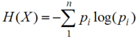
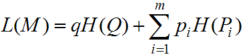
Figure 1 Detecting communities of information flows within networks
In terms of network data, node weight, edge weight, and linkage direction are important attributes for illustrating community structures in the real world network. However, most of the traditional algorithms are currently unable to take directed and weighted networks into consideration and so often implement network partitioning that does not incorporate actual attribute information of linkage weight and direction. Thus, different algorithms exhibit variable performance characteristics depending on environment and may even be significantly biased compared to reality. The Infomap algorithm, which is almost the only algorithm that can consider topological properties such as node weight, edge weight and linkage direction and also can take higher-order network data into consideration, exhibits significant adaptability and consistent performance. The related research has shown that the Infomap method has been one of the best performing community detection algorithms (Lancichinetti and Fortunato, 2009; Zhong et al., 2014) suitable for weighted and directed networks. Here, we see a city as a node of networks and the linkage strength of a city as the weight of a node. Thus, the network edges can be expressed via the intercity linkages and the edge weights can be expressed via the linkage frequencies between cities. All data processing and algorithm implementation were performed on the R platform (Csardi and Nepusz, 2006).
2.2.2 Network visualization
Geographical science emphasizes spatial patterns, processes, and internal logic of “space of flows”; thus, statistical modeling and visualization provide key approaches to quantitatively measure “space of flows”. Generally speaking, topological networks can have a good performance in describing topological relationships and attributes, especially accurately depicting the detailed characteristics of networks. However, they often tend to lose effectiveness when indicating geographical space. Geographical networks have natural advantages in expressing spatial structures and forms of real geographical environments, while their drawbacks in portraying detailed features emerge when facing large data volume in complex network analysis. Therefore, we attempt to integrate topological and geographical networks in this study in order to enable a deeper understanding of the spatial structures and organizational patterns of city networks in China based on highway flows.
Chord Diagram, as a new-type topological network visualization method, enables us to convert network data into graphical representation that has been widely adopted to interpret topological relationships and attributes of nodes in networks. Specifically, chord diagram takes each node as an arc and the linkage between arcs as a chord; the arcs with different colors indicate different nodes while the chords with different colors express different topological relationships between different nodes, and the relative sizes of arcs and chords depend on the attributes of nodes and linkages between nodes.

3 The macro-spatial configuration of China’s city networks

In traditional studies, the connections between cities and regions, which can be measured through geographical factor distribution or the use of gravity models, have been used to illustrate hierarchical structures and static patterns. Nevertheless, contemporary urban studies based on relational data have led to new perspectives that are more open, dynamic, and networked; the highway flow values are typical examples of such new relational data. As demonstrated in Figure 2, the macro- spatial configuration of city networks in China was visualized. The spatial distribution of highway flows shows significant spatial heterogeneity and the spatial correlation form of city networks represents strong spatial dependence and hierarchical characteristics. Furthermore, these macro-spatial patterns also reveal obvious spatial coupling with major megaregions in China and predominantly reflect the spatial relationships and core-periphery structures at regional scales.
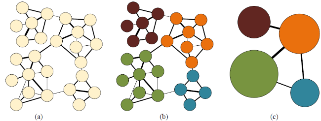
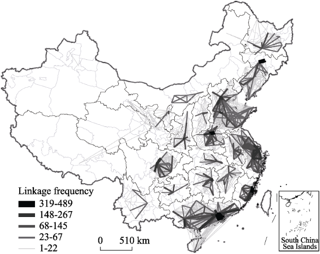
Figure 2 The macro-spatial configuration of China’s city networks
On the whole, the intercity highway flows are mainly distributed in eastern coastal areas, especially within the megaregions of Beijing-Tianjin-Hebei (BTH), Shandong Peninsula (SDP), Yangtze River Delta (YRD), Western Taiwan Straits (WTS), and Pearl River Delta (PRD), together constituting a dense and spatially-correlated urban belt in China. In addition to these regions, the major economic zones of northeastern, central, and western China, based on the core cities, form the city regions of intense external flows. In terms of intercity spatial correlation, the YRD megaregion comprises a polycentric, multi-level city network pattern. The urban areas within this region tend to be closely interconnected, while the economic impact of the YRD megaregion has spread into neighboring Anhui Province. Similarly, the PRD megaregion, including the core cities of Guangzhou and Shenzhen, is characterized by a morphology that consists of highly external linkages and a certain degree of connectivity to neighboring provincial units of Fujian and Guangxi. The BTH megaregion, in contrast, centered on the megacity of Beijing, is characterized by the formation of radial associations with surrounding regions. Some of these connections extend southwards to cities in western Shandong Province, establishing the Beijing-Tianjin-Hebei-Shandong city networks. The Chengdu-Chongqing (CCQ) region is also characterized by the presence of intertwined city networks with surrounding cities, showing typical dual-nuclei driving development dynamics. In contrast, although the Central Plains Economic Zone (CPL) is characterized by a relatively high average network density, it nevertheless still conforms overall to a monocentric trend in development. In northeastern China, it has constituted a radial spatial correlation pattern based on the central city of Harbin in the northern part, and the central Jilin megaregion is characterized by the highest connectivity between the cities of Changchun and Jilin, and the Liaoning Peninsula (LNP) megaregion is concentrated on the nodal city of Shenyang in the south. Although interactive networks within provincial units are also seen in other regions of China, their overall connectivity remains relatively weak compared to the above major megaregions.

4 Regional effects of city networks in China

Based on highway flows between cities, we subdivided 289 prefecture-level administrative units into 19 communities using the community structure detection method (Infomap algorithm), in which nodes are more closely interconnected than nodes outside the communities, as shown in Figure 3. In terms of the spatial scale, these communities are smaller than the traditional regional division of “the Three Regions”(Traditionally, China has long been divided into eastern, central, and western regions on the basis of the natural background and the socioeconomic development status in the national macro policy system for a long time.) and “Four Major Economic Regions”(In recent years, in order to scientifically reflect the socioeconomic development status, Chinese government agencies have divided the national economic region into the eastern, the central, the western, and the northeastern China.), they are nevertheless larger than either metropolitan areas or megaregions. In this study, we suggest they are correspondingly urban economic regions for identifying the regional structures of intercity relationships within China. Urban economic region, as an emerging spatial organization mode in the functional regional system of China, has engendered a fresh perspective and understanding in terms of framing urban and regional space. In comparison with the previous division schemes (Gu, 1991; Zhou and Zhang, 2003), our empirical findings show some similarity, but some new urban and regional structures have been identified. Specifically, the spatial implications are demonstrated as follows:
(1) Administrative region economy
Administrative boundary is a fundamental element to understand regional economy and spatial interaction. The urban economic regions identified on the basis of spatial linkages, are certainly consistent with the provincial administrative boundaries to a great extent, showing significant characteristics of administrative economy. On the one hand, some provincial administrative boundaries are basically resulted from the natural geographical borders. For example, the Taihang Mountains are the borders between Shanxi and Hebei provinces; the Wuyi Mountains running along the boundary between Jiangxi and Fujian provinces; and the Nanling Mountains are the natural boundaries separating Guangdong Province and Guangxi Zhuang Autonomous Region from Fujian, Jiangxi and Hunan provinces. Due to these physical geographical barriers, some regions form relatively closed or semi-closed regional economic spaces, such as the provinces of Fujian, Jiangxi, Hunan and Sichuan. In these regions, there are internally higher connections between cities, while lower intensities with cities outside these areas. On the other hand, under the institutional framework of “dominant government, weak market” and ”top-down decentralization” in contemporary China, cities tend to exhibit significant advantages in terms of resource allocation, factor mobility, infrastructure sharing, and regional division and coordination within the same province and thus develop into individual regional economic system within the inherent territories. Indeed, due to these factors such as administrative governance system and policy barrier, factor mobility across administrative borders can usually be constrained and hindered to a considerable degree.
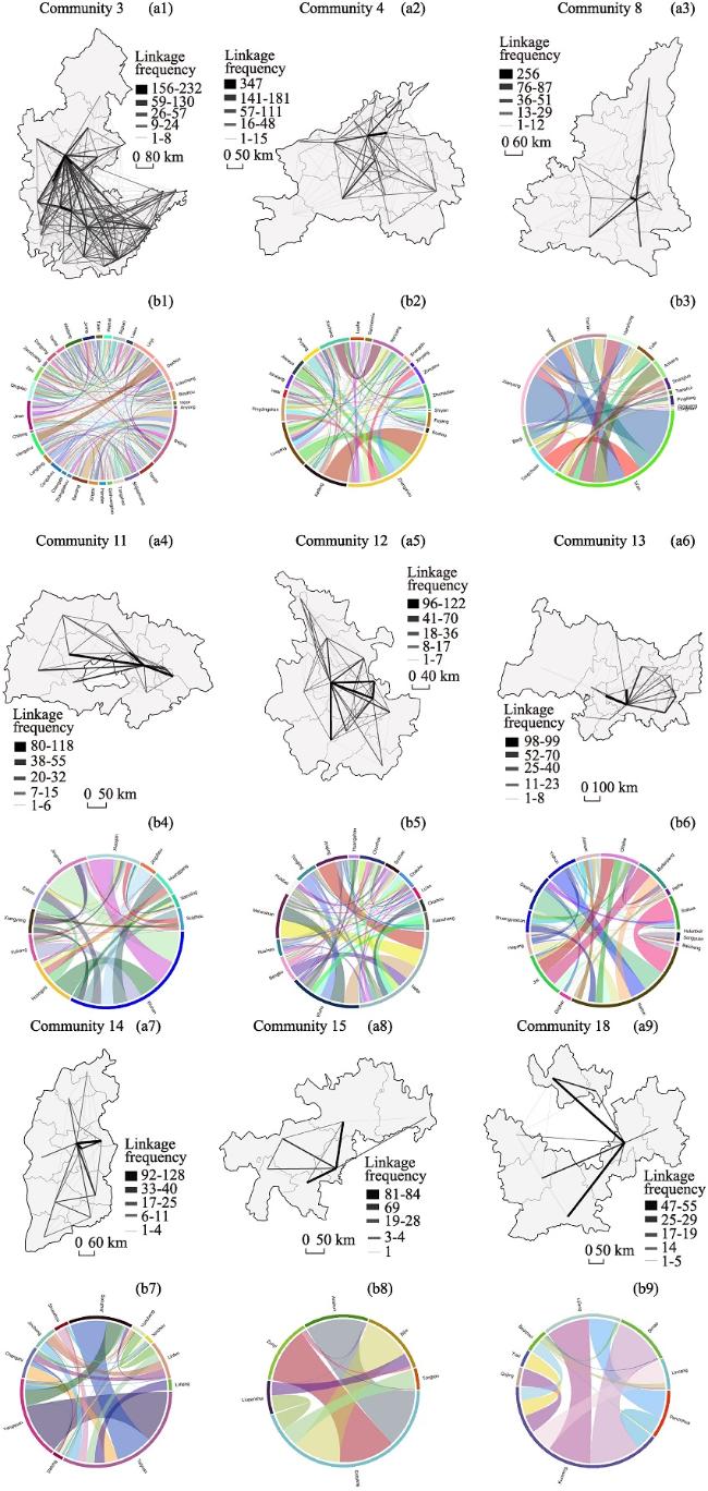
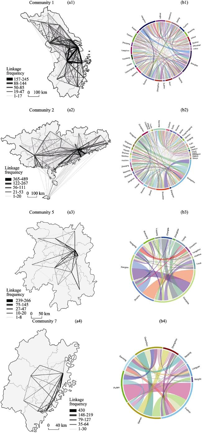
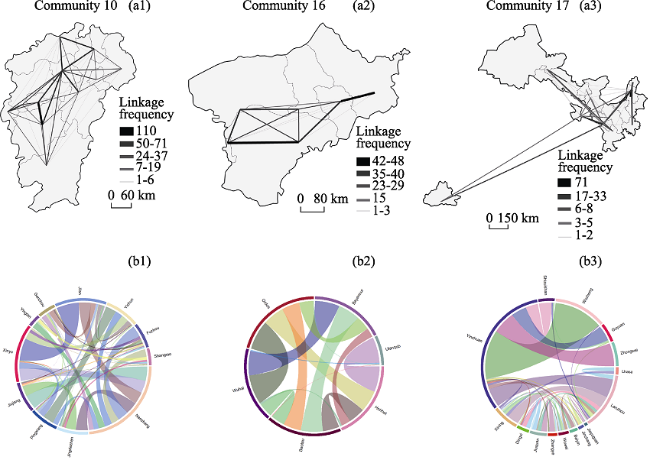
Figure 3 Community structures based on spatial linkages
(2) Spatial spillover effects of megaregions
Megaregions, as globalization’s new urban form, constitute trans-metropolitan landscapes comprising networked urban centers and their surrounding areas (Harrison and Hoyler, 2015). Within megaregions, the presence of enhanced socioeconomic activities has exerted correspondingly strong influence on the formation of dense inter-regional or even inter-provincial linkages that span administrative borders and has thus led to marked spatial spillover effects. As is mapped in Figure 3, there are some urban economic regions crossing provincial administrative boundaries including Community 1, Community 2 and Community 3. In eastern China, Shanghai, Jiangsu and Zhejiang provinces are divided into one community (Community 1). The YRD megaregion centered on Shanghai, as the most developed region in China, has strong economic radiation capacities and frequent factor flows. Regional spatial structures tend to be polycentric and networked development stage with significant tendency for regional economic integration. In southern China, Guangdong and Guangxi are classified into the same community (Community 2). The PRD has been one of the most developed megaregions with dramatically driving and influencing capacities on the surrounding regions. Guangxi and Guangdong are both located on the south of Nanling Mountains and belong to the Pearl River Basin. They share similarity in the physical geography, historical accumulation and sociocultural context. They have close social and economic relations for a long time and now the Zhujiang-Xijiang economic belt has been proposed as national strategy. In northern China, Beijing, Tianjin, and provinces of Hebei and Shandong are divided into the same group. Beijing and Tianjin, as the nodal cities, have acted as the engines for economic growth within the BTH megaregion; as a result, its economic radiation capacity has spread to the neighboring Shandong Province that finally formed the Beijing, Tianjin, Hebei and Shandong community.
(3) Core-periphery structure
The division of urban economic regions, based on highway flows, has shown obvious characteristics of administrative region economy and provincial administrative boundaries have also acted as important dividing lines within different regions. At the same time, however, it is also clear that some cities located near provincial borders have become disconnected from their own administrative frameworks and have consequently been incorporated into the economic zones of neighboring provinces. For example, the Tongliao city of Inner Mongolia Autonomous Region has close links with Liaoning and Jilin provinces so that they together form Community 9. Similarly, the cities of Chifeng and Anyang, located in the border regions of Inner Mongolia and Henan, respectively, are both divided into the Beijing-Tianjin-Hebei-Shandong community (Community 3); the cities of Fuyang and Bozhou in the northwest of Anhui Province are attracted into the Central Plain economic region (Community 4); the cities of Tianshui, Pingliang, Qingyang, and Longnan in southern Gansu Province all exhibit close connections with the Shaanxi community centered around the city of Xi’an (Community 8); the cities of Chengdu and Chongqing with surrounding small and medium-sized cities are integrated into one group (Community 6); the cities of Baicheng and Songyuan in Jilin Province have deeper connections with neighboring Heilongjiang Province (Community 13); the Panzhihua city as the southernmost city in Sichuan Province is grouped into Yunnan community (Community 18). Indeed, because of their geographical locations and physical surroundings, many cities in provincial border regions usually receive limited economic influence from economic centers in their own provinces and tend to be shadow regions of resource allocation and policy coverage. Therefore, these cities are more easily attracted by powerful economic centers in neighboring provinces and get rid of administrative constraints to amalgamate with adjacent cities and regions.

5 Regional network structures and spatial organization

In previous sections, we applied the community detection method to subdivide Chinese prefecture-level administrative units into 19 urban economic regions (or communities). These urban economic regions, as important components of the spatial configuration in Chinese urban system, portray clear spatial patterns of regional city networks from a spatial linkage perspective and help to understand the spatial dependence structures in different territorial systems. We build on these results to further visualize the geographical space and topological properties of individual territorial systems based on the spatial dimensions of urban economic regions (Figure 4).
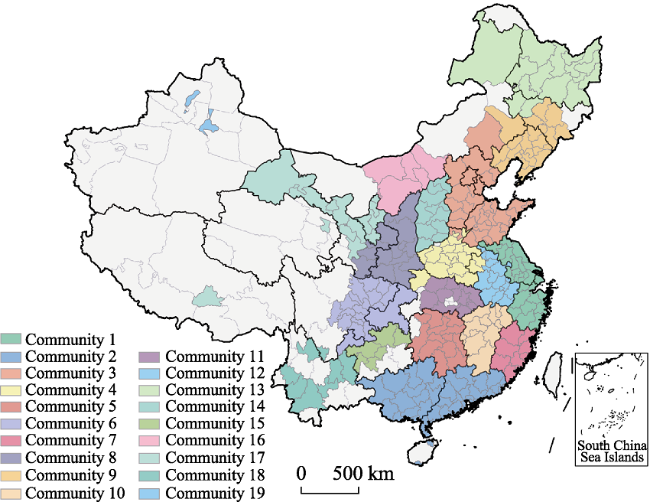
Figure 4 The spatial configuration of China’s city networks based on community detection
Overall, each of the communities is characterized by a marked city network system that exhibits strong spatial dependence and various spatial organization patterns. Specifically, the densest communities identified in this research are those that comprise Shanghai-Jiangsu-Zhejiang, Guangdong-Guangxi, and Beijing-Tianjin-Hebei-Shandong, followed by Chengdu-Chongqing, Henan, and Liaoning-Jilin. It is therefore clear that highway flows can be utilized to most effectively illustrate the important role played by spatial distances in regional structures of interactions. Results also reveal that within a single regional system, spatial correlation patterns have often formed with a central city at the core and with intercity connectivity spreading outwards from the central city to the surrounding cities due to the law of distance decay. Thus, from a morphological perspective, the spatial structure of regional city networks can be broadly classified as either monocentric, dual-nuclei, polycentric, or low-level equilibration structures. Most regional city networks in China have developed following a monocentric pattern; this kind of regional development system characterizes Community 3, Community 4, Community 8, Community 11, Community 12, Community 13, Community 14, Community 15, and Community 18, while a dual-nuclei regional system characterizes Community 6 and Community 9, a polycentric regional system characterizes Community 1, Community 2, Community 5, and Community 7, and a regional system with a low-level of equilibrium structure characterizes Community 10, Community 16, and Community 17.

5.1 Monocentric development model

A monocentric regional system often centers on a single large city as its core; this large city is closely connected to adjacent small and medium-sized cities and, the system thus encapsulates a spatial organization pattern of core-periphery structure. Such a monocentric urban system also tends to display rank-size structures and the characteristics of vertical linkage, as the single core city dominates the entire region and surrounding small and medium-sized cities show obviously spatial directivity towards this regional center. Thus, during the initial stage of regional economic development, the regional central city tends to enter the status of agglomeration and expansion, and often has strong siphonic effects on all kinds of resources and policies, such as capital, investment, talent, population, and information. These all lead to varying degrees of spatial polarization. Due to the regional circulation and accumulated effect, increased volumes of high quality resources and development opportunities tend to flow to the core city or larger urban areas and so a monocentric regional structure gradually develops. The monocentric spatial structure is therefore a natural geographic phenomenon alongside the processes of socioeconomic development, which enables both rationality and inevitability in a particular development stage.
From a spatial morphology perspective, regional city networks in China based on highway flows mainly demonstrate monocentric development model, and the spatial structures include radial, ring-shaped, and fan-shaped spatial interaction morphology. In these regions, central cities tend to occupy dominant positions while sub-center cities tend to be under-developed, indicative to a certain extent of current situation of regional economic development in China. Among the 19 communities identified above, nine of the whole communities exhibit monocentric spatial structures to some extent. Detailed results are shown in Figure 5, among which the label (a) represents the geographic network, the label (b) represents the topological network.
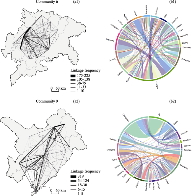
Figure 5 The spatial organization of regional city networks based on monocentric structures

5.2 Dual-nuclei development model

A dual-nuclei development model is, as the name implies, a spatial operation mechanism of regional development driven by two central cities. Within a territorial system, the dual-nuclei spatial structure usually comprises two central cities acting as core development engines that are closely interconnected with a series of surrounding small and medium-sized cities; taken together, these cities constitute a multi-level, networked urban system. In com parison with monocentric spatial structure, dual-nuclei spatial structure owns its distinguished characteristics. On the one hand, the two central cities are often separated by a certain
distance in geographical space and respectively form their own city network systems in individual hinterland. On the other hand, however, these two urban systems often have considerable crossover and overlap that some cities in one urban system also have certain linkages with cities in the other urban system and high-ranking cities tend to be frequently interconnected beyond administrative boundaries. In such a situation, the regional development model driven by “two engines” that integrates rank-size and functional network is likely to take shape.
In China’s regional city networks, both Chengdu-Chongqing region (Community 6) and Liaoning-Jilin region (Community 9) show, to some extent, dual-nuclei development model (Figure 6). In these two communities, the nodal cities respectively develop their own subsystems, and dense connectivity also exists between the subsystems, finally forming relatively typical regional development model driven by “two engines”.
Figure 6 The spatial organization of regional city networks based on dual-nuclei structures

5.3 Polycentric development model

Along with socioeconomic development, production factors such as population, industries, and resources tend to constantly concentrate towards central cities. As a result, urban areas and populations of central cities continue to expand, often leading to urban development problems such as urban sprawl, traffic congestion, shortages of housing, and resources and environment deterioration. Previous work has shown that such ‘urban’ or ‘regional diseases’ are more likely to occur in cities and regions that have monocentric spatial structures. Thus, given this background, governments and academic researchers around the world have noted that a polycentric spatial structure appears to provide a more efficient and stable
model for regional development; as a result, this kind of spatial organization of polycentric structure has gradually become more and more critical in the promotion of urban and regional sustainable development. The polycentric spatial structure proposes that the regional economy should be transformed from one that is dominated by administrative divisions to one that is orientated towards relational geographies, and the traditional monocentric spatial structures should be promoted to evolve into new spatial organizational models of regional development that are multi-level, dynamic, and networked.
Generally speaking, the polycentric development model would encompass several central cities as the cores and would rely on well-developed infrastructural networks, forming substantial spatial relationships and functional networks for resource sharing, factor mobility and division cooperation with surrounding small and medium-size cities. In the divided communities, Shanghai-Jiangsu-Zhejiang community (Community 1), Guangdong-Guangxi community (Community 2), Hunan community (Community 5), and Fujian community (Community 7) all conform to varying degrees with a polycentric development model. In terms of spatial morphology, the Shanghai-Jiangsu-Zhejiang community centered on the YRD megaregion and the Guangdong-Guangxi community centered on the PRD megaregion are both characterized by sophisticated polycentric structure developmental morphologies. Similarly, the Hunan community centered on Changsha-Zhuzhou-Xiangtan megaregion and the Fujian community centered on Fuzhou and Xiamen display some characteristics consistent with the early regional development of morphological polycentricity although they remain in a primary stage.
Figure 7 The spatial organization of regional city networks based on polycentric structures

5.4 Low-level equilibration development model

Given a specific set of spatiotemporal circumstances, cities within a given region can share similar socioeconomic development characteristics while their socioeconomic activities and linkages in this context remain relatively balanced. As this region has no significant economic centers and growth poles, cities will tend to be characterized by relatively balanced levels and patterns of development. In terms of spatial organization, in addition to monocentric, dual-nuclei, and polycentric structures, the city networks in some communities in this context are also at a low, but balanced, stage of development. No obvious core engines are present within these regions, and they are characterized by small economic scale, slow factor mobility, and limited linkage strength. These regions (or communities) are not balanced and integrated regions driven by the highly-developed regional economy and in fact they are usually under-developed areas. As shown in Figure 8, the Jiangxi region (Community 10), the central and western Inner Mongolia (Community 16), the Gansu-Ningxia-Qinghai-Tibet region (Community 17), and the Xinjiang region (Community 19) all comprise these kinds of regions (Figure 8).
Figure 8 The spatial organization of regional city networks based on low-level equilibration structures

6 Conclusions and discussion

Urban and regional studies utilizing relational data enable new perspectives of more open, dynamic and networked. As a result, the use of multi-perspective and multi-scalar city network has gradually become more and more important as the basis of our understanding of spatial interactions and linkages. Road linkages provide some distinguishing characteristics that reveal spatial dependence and distance decay, and have proven to be of great significance in depicting spatial relationships at the regional scale. Utilizing data on highway passenger flows between prefecture-level administrative units, the aim of this paper was to identify functional structures and regional impacts on city networks in China, and to further explore patterns in the spatial organization of existing functional regions. The results of this study enable a deeper understanding of the structures of city networks and provide a number of new cognitive perspectives for future research. The empirical results are shown as follows.
(1) It is immediately evident that highway flows are markedly concentrated within the megaregions of eastern coastal China and major economic zones in central and western China. And city networks constructed on the basis of highway flow data exhibit strong spatial dependence and hierarchical characteristics, spatially coupled to a large extent with the distribution of major megaregions in China. This trend is therefore more of a reflection of spatial relationships at the regional scale as well as core-periphery structures.
(2) Nineteen communities that belong to an important type of spatial configuration are identified through community detection algorithm, and we suggest they are correspondingly urban economic regions within urban China. Their spatial metaphors can be concluded in three aspects. Firstly, many of these communities share the same boundaries with provincial-level administrative units, demonstrating significant administrative regional economy still exists in contemporary China. Secondly, trans-provincial linkages can be formed though the spatial spillover effects of megaregions within specific communities. Thirdly, cities located in marginal areas of provinces that are attracted by powerful central cities in neighboring provinces, are likely to become increasingly disconnected with their own provinces and be enrolled into communities of neighboring provinces, which contributes to the formation of the trans-provincial core-periphery structures.
(3) Each community can be characterized by a particular city network system, demonstrating strong spatial dependence and various spatial organization patterns. Regional patterns have emerged with the features of multi-level, dynamic, and networked. From the point-of-view of morphology, the spatial structures of regional city networks can basically be divided into monocentric, dual-nuclei, polycentric, and low-level equilibration structures. The majority, however, have developed according to a monocentric pattern.
In contemporary urban geography, both the research directions and spatial scales have been gradually enhanced while the empirical studies of multi-perspective and multi-scalar city networks have significantly deepened the regional cognition of city network development in China. The aim of this paper was therefore to depict the spatial structures and organization patterns of China’s city networks using highway passenger flows. The main contribution of this study is its attempt to rectify existing weaknesses inherent to the use of macro-scale highway flow data in the portrayal of regional interrelated structures and spatial organizations, which will broaden the existing research perspective on city network that are subject to strong distance decay and promote a clearer understanding of the roles played by geographical distance and city hierarchy in city network development. Nevertheless, taking into account the inaccessibility of real traffic flows, the bus schedule data used in this study is necessarily a type of parameter substitution to real flow data. Due to the limitations of data sources and web crawling techniques, this research neglects the spillover effect of actual schedules caused by “station stops along the road networks” in real highway passenger transportation. Meanwhile, we were unable to obtain highway flow data at finer scales and it will be of great value to the identification of regional structures and interconnected patterns of city networks at the county-level scale. Research on multi-scalar city network is continuously deepening the fundamental urban system theory, enabling a range of new perspectives and theoretical cognition for spatial relationships at different spatial scales, which is also an important development direction in future urban studies.

The authors have declared that no competing interests exist.

[1]
Alderson A S, Beckfield J, 2004. Power and position in the world city system.American Journal of Sociology, 109(4): 811-851.Globalization has renewed interest in the place and role of cities in the international system. Recent literature proposes that the fate of cities (and their residents) has become increasingly tied to their position in international flows of investment and trade. Data on the branch locations of the world’s 500 largest multinational enterprises in 2000 are subjected to two broad types of network analytic techniques in order to analyze the “world city system.” First, 3,692 cities are analyzed in terms of three measures of point centrality. Second, blockmodeling techniques are employed to generalize further about the positions and roles played by cities in the system. These techniques are used to trace out the structure of the world city system, locate cities in the context of a global urban hierarchy, and explore the degree to which this diverges from a simple one‐to‐one matching of cities onto nation‐states in the world system.

DOI

[2]
Beaverstock J V, Smith J, 1996. Lending jobs to global cities: Skilled international labour migration, investment banking and the city of London.Urban Studies, 33(8): 1377-1394.

DOI

[3]
Blondel V D, Guillaume J L, Lambiotte Ret al., 2008. Fast unfolding of communities in large networks.Journal of Statistical Mechanics: Theory and Experiment, 2008(10): P10008.

DOI

[4]
Camagni R, Capello R, 2004. The city network paradigm: Theory and empirical evidence. In: Capello R, Nijkamp P (eds). Urban Dynamics and Growth: Advances in Urban Economics. Amsterdam: Elsevier.

[5]
Castells M, 2010. Globalisation, networking, urbanisation: Reflections on the spatial dynamics of the information age.Urban Studies, 47(13): 2737-2745.The network society is a global society because networks have no boundaries. Spatial transformation is a fundamental dimension of this new social structure. The global process of urbanisation that we are experiencing in the early 21st century is characterised by the formation of a new spatial architecture in our planet, made up of global networks connecting major metropolitan regions and their areas of influence. Since the networking form of territorial arrangements also extends to the intrametropolitan structure, our understanding of contemporary urbanisation should start with the study of these networking dynamics in both the territories that are included in the networks and in the localities excluded from the dominant logic of global spatial integration.

DOI

[6]
Chen W, Xiu C L, Ke W Qet al., 2015. Hierarchical structures of China’s city network from the perspective of multiple traffic flows.Geographical Research, 34(11): 2073-2083. (in Chinese)Traffic flow acts as a major carrier of other flows (including people, goods, capital, etc.), thus the study on traffic flow is of great significance to understand intercity interaction. Based on the 321 cities at prefecture level or above, this article explores spatial linkage of China's city network using intercity linkage data of road, rail and air transport. The research results show that: (1) The spatial correlation of city network based on road linkage displays strong spatial dependence, which is very useful to identify urban agglomerations and assess developments. Besides the most developed regions including Yangtze River Delta, Pearl River Delta and Beijing-Tianjin-Hebei urban agglomerations, some important urban agglomerations have emerged, such as Zhongyuan, Harbin-Daqing-Qiqihar, Central Jilin, Central-southern Liaoning, Shandong Peninsula, Guanzhong, West coast of Taiwan Straits, Wuhan, Central Yunnan, Changsha-Zhuzhou-Xiangtan. (2) The railway linkage flow reflects intercity external connection pattern, regional element relevancy and regional accessibility along with national railway artery. "Two horizontal and three longitudinal" zonal distribution patterns composed of Beijing-Guangzhou, Beijing-Harbin, Beijing-Shanghai Railway and Longhai-Lanxin, Shanghai-Kunming Railway, constitute the urban network backbone and have become the most important economic axial belts for national territorial development. (3) The "diamond structure" as the core framework basically forms the skeleton of urban network system from the perspective of air passenger flow, whose vertices are Beijing, Shanghai, Guangzhou-Shenzhen and Chengdu-Chongqing. Generally speaking, different types of traffic flows reflect different patterns of intercity linkage, namely, there also exists internal relationship. Air passenger flow constitutes the backbone of intercity linkage pattern, railway linkage flow acts as supporting axis belts for the core framework, and road linkage is a bridge connecting main skeleton and supporting belts. All types of traffic flows collectively form interdependent and indispensable element correlation and spatial relationship among regions.

DOI

[7]
Clauset A, Newman M E J, Moore C, 2004. Finding community structure in very large networks.Physical Review E, 70(6): 066111.Abstract The discovery and analysis of community structure in networks is a topic of considerable recent interest within the physics community, but most methods proposed so far are unsuitable for very large networks because of their computational cost. Here we present a hierarchical agglomeration algorithm for detecting community structure which is faster than many competing algorithms: its running time on a network with n vertices and m edges is O (md log n) where d is the depth of the dendrogram describing the community structure. Many real-world networks are sparse and hierarchical, with m approximately n and d approximately log n, in which case our algorithm runs in essentially linear time, O (n log(2) n). As an example of the application of this algorithm we use it to analyze a network of items for sale on the web site of a large on-line retailer, items in the network being linked if they are frequently purchased by the same buyer. The network has more than 400 000 vertices and 2 x 10(6) edges. We show that our algorithm can extract meaningful communities from this network, revealing large-scale patterns present in the purchasing habits of customers.

DOI PMID

[8]
Csardi G, Nepusz T, 2006. The igraph software package for complex network research.InterJournal, Complex Systems, 1695(5): 1-9.The igraph software package provides handy tools for researchers in network science. It is an open source portable library capable of handling huge graphs with millions of vertices and edges and it is also suitable to grid computing. It contains routines for creating, manipulating and visualizing networks, calculating various structural properties, importing from and exporting to various file formats and many more. Via its interfaces to high-level languages like GNU R and Python it supports rapid development and fast prototyping.

[9]
Derudder B, Taylor P J, Hoyler Met al., 2013. Measurement and interpretation of connectivity of Chinese cities in world city network, 2010.Chinese Geographical Science, 23(3): 261-273.

DOI

[10]
Derudder B, Witlox F, 2008. Mapping world city networks through airline flows: Context, relevance, and problems.Journal of Transport Geography, 16(5): 305-312.This paper contextualises and reviews the burgeoning research in which data on air passenger flows are used to analyse a network of world cities. Rather than taking the relevance of such airline statistics on trust, we consider their advantages and drawbacks in the context of the different approaches devised in the empirical research at large. To assess the potential of data on air passenger flows in this context, we construct a taxonomy of approaches that distinguishes between information on global corporate organization and large-scale infrastructure networks. While this evaluation suggests that information on air passenger flows may indeed be a prime data source in this context, it is equally clear that the relevance of such research is potentially undermined by inadequate statistics. It is argued that future research should explore and/or construct alternative airline datasets that allow for more meaningful analyses.

DOI

[11]
Dong C, Xiu C L, Wei Y, 2014. Network structure of ‘space of flows’ in Jilin Province based on telecommunication flows.Acta Geographica Sinica, 69(4): 510-519. (in Chinese)Information communication is an important expression of interaction between two cities, and it is also a key element to build the city network. This study proposes to map the network structure of 'space of flows' based on the actual observed telecommunication flows,with Jilin Province as the case area. Specifically, the call durations via fixed- line telephone are employed to measure the information flows occurred between cities. The cities at the county level or above are treated as research units. To be reliable, a synthetic method composed of principal component analysis, C-Value and D-Value hierarchy analysis, dominant flow analysis, the minimum spanning tree method is utilized to map out the structure. The research reveals the following aspects.(1) The 'space of flows' in Jilin Province is a hierarchical network, which centers on Changchun. In this network, Changchun, Yanji,Tonghua and Gongzhuling are the 1st-level leading cities; Jilin, Baicheng, Baishan, Liaoyuan,Songyuan and Siping are 2nd-level leading cities, and the other cities in Jilin are subordinate cities.(2) Administrative division plays a fundamental role in the formation of the current pattern.(3) Changchun is a unique center, but on the contrary to our previous understanding,Jilin is not that 'centric', and the interaction between Changchun and Jilin is not that strong either.(4) Surprisingly, the two cities of Gongzhuling and Dunhua at the county level, play important roles in the network of 'space of flows'. Gongzhuling tends to be blended in the Changchun metropolitan area, and Dunhua becomes a key node in the eastern Jilin. The regional connectivity functions of the two cities need to be improved.(5) Siping and Lishu,have strong interaction with each other, and are supporting a further integration strategy of the two neighboring cities.

DOI

[12]
Girvan M, Newman M E J, 2002. Community structure in social and biological networks.Proceedings of the National Academy of Sciences, 99(12): 7821-7826.

DOI

[13]
Gu C L, 1991. A preliminary study on the division of urban economic regions in China.Acta Geographica Sinica, 46(2): 129-141. (in Chinese)If a nodel point exist in a nodal region, there is a link figure through two or more delta-shaped regions. This paper applies d system theory and Rd chain method for the division of urban economic region. 434 cities in China have been evaluated by their urban comprehensive strength index by R type factors analysis method. 102 cities of them are regarded as nodel points in Chinese nodal region. The author further classify them into three levels. In different levels, these nodal points are linked each other and formed dA system and Rad .chain. According to levels of dA system and Rd chain, China can be delineated into two pars, three economic developing axes, and nine urban economic regions.

[14]
Hall P, Pain K, 2006. The Polycentric Metropolis: Learning from Mega-city Regions in Europe. London: Earthscan.ABSTRACT Book description: 'Large polycentric city-regions pose perplexing problems to social scientists and policy-makers. Not only do they represent complex socio-economic systems in their own right, but they also increasingly function as the main locational anchors of wider globalization processes. This book provides a masterful analysis of these issues, with a particular focus on the emergence, dynamics, and planning of polycentric city-regions in contemporary Europe' Allen Scott of University of California, and author of Global City-Regions. A new 21st century urban phenomenon is emerging: the networked polycentric mega-city region. Developed around one or more cities of global status, it is characterized by a cluster of cities and towns, physically separate but intensively networked in a complex spatial division of labour. This book describes and analyses eight such regions in North West Europe. For the first time, this work shows how businesses interrelate and communicate in geographical space - within each region, between them, and with the wider world. It goes on to demonstrate the profound consequences for spatial planning and regional development in Europe - and, by implication, other similar urban regions of the world. The Polycentric Metropolis introduces the concept of a mega-city region, analyses its characteristics, examines the issues surrounding regional identities, and discusses policy ramifications and outcomes for infrastructure, transport systems and regulation. Packed with high quality maps, case study data and written in a clear style by highly experienced authors, this will be an insightful and significant analysis suitable for professionals in urban planning and policy, environmental consultancies, business and investment communities, technical libraries, and students in urban studies, geography, economics and town/spatial planning.

DOI

[15]
Harrison J, Hoyler M, 2015. Megaregions: Globalization’s New Urban Form? Cheltenham: Edward Elgar.

[16]
Hoyler M, Kloosterman R C, Sokol M, 2008. Polycentric puzzles-emerging mega-city regions seen through the lens of advanced producer services.Regional Studies, 42(8): 1055-1064.This paper introduces a special issue of Regional Studies on 'Globalization, City-Regions and Polycentricity in North West Europe'. The issue focuses on the thematic core of the EU-funded project POLYNET: the analysis of economic connections and information flows generated by advanced producer services in eight European polycentric city-regions. The paper first discusses key elements of the current debate on global city-regions and points out some unresolved gaps. A summary of the main findings of the contributions to the special issue is followed by a research agenda for future work on emerging mega-city regions.

DOI

[17]
Lancichinetti A, Fortunato S, 2009. Community detection algorithms: A comparative analysis.Physical Review E, 80(5): 056117.

DOI

[18]
Liu W D, Zhen F, 2004. Spatial implications of new information and communication technologies.Acta Geographica Sinica, 59(S1): 67-76. (in Chinese)Recent decades have witnessed extraordinary advances in information and communication technologies (ICTs), which have helped to change social and economic life. Such changes have drawn much attention from scholars in various academic fields, and have initiated fervent debates on the spatial implications of new ICTs. Geographers have been prominent, particularly in contesting the popular view that distance no longer matters and that "the end of geography" is at hand. With these debates, urban and regional development under new ICTs has become a hot issue in geographical studies. This paper, mainly based on literature in English journals, tries to review and summarize the studies on spatial impacts of new ICTs at three levels, i.e. regional restructuring, urban restructuring and firm-level restructuring. Existing literature reveals that new ICTs have played an increasingly important role in the spatial transformations of the economy in the last several decades, but they are "an enabling or facilitating agent". Since there exists a gap between the introduction of new ICTs and changes in the spatial pattern of firms, empirical evidence is still insufficient for drawing firms on new ICT impacts. Overally, the spatial transformations at firm level have not yet been given enough attention by geographers.

[19]
Malecki E J, 2002. The economic geography of the Internet’s infrastructure.Economic Geography, 78(4): 399-424.

DOI

[20]
Pons P, Latapy M, 2006. Computing communities in large networks using random walks.Journal of Graph Algorithms and Applications, 10(2): 191-218.Abstract: Dense subgraphs of sparse graphs (communities), which appear in most real-world complex networks, play an important role in many contexts. Computing them however is generally expensive. We propose here a measure of similarities between vertices based on random walks which has several important advantages: it captures well the community structure in a network, it can be computed efficiently, it works at various scales, and it can be used in an agglomerative algorithm to compute efficiently the community structure of a network. We propose such an algorithm which runs in time O(mn^2) and space O(n^2) in the worst case, and in time O(n^2log n) and space O(n^2) in most real-world cases (n and m are respectively the number of vertices and edges in the input graph). Experimental evaluation shows that our algorithm surpasses previously proposed ones concerning the quality of the obtained community structures and that it stands among the best ones concerning the running time. This is very promising because our algorithm can be improved in several ways, which we sketch at the end of the paper.

DOI

[21]
Raghavan U N, Albert R, Kumara S, 2007. Near linear time algorithm to detect community structures in large-scale networks.Physical Review E, 76(3): 036106.Community detection and analysis is an important methodology for understanding the organization of various real-world networks and has applications in problems as diverse as consensus formation in social communities or the identification of functional modules in biochemical networks. Currently used algorithms that identify the community structures in large-scale real-world networks require a priori information such as the number and sizes of communities or are computationally expensive. In this paper we investigate a simple label propagation algorithm that uses the network structure alone as its guide and requires neither optimization of a predefined objective function nor prior information about the communities. In our algorithm every node is initialized with a unique label and at every step each node adopts the label that most of its neighbors currently have. In this iterative process densely connected groups of nodes form a consensus on a unique label to form communities. We validate the algorithm by applying it to networks whose community structures are known. We also demonstrate that the algorithm takes an almost linear time and hence it is computationally less expensive than what was possible so far.

DOI PMID

[22]
Rosvall M, Bergstrom C T, 2008. Maps of random walks on complex networks reveal community structure.Proceedings of the National Academy of Sciences, 105(4): 1118-1123.Abstract: To comprehend the multipartite organization of large-scale biological and social systems, we introduce a new information theoretic approach that reveals community structure in weighted and directed networks. The method decomposes a network into modules by optimally compressing a description of information flows on the network. The result is a map that both simplifies and highlights the regularities in the structure and their relationships. We illustrate the method by making a map of scientific communication as captured in the citation patterns of more than 6000 journals. We discover a multicentric organization with fields that vary dramatically in size and degree of integration into the network of science. Along the backbone of the network -- including physics, chemistry, molecular biology, and medicine -- information flows bidirectionally, but the map reveals a directional pattern of citation from the applied fields to the basic sciences.

DOI

[23]
Taylor P J, 2001. Specification of the world city network.Geographical Analysis, 33(2): 181-194.Abstract World cities are generally deemed to form an urban system or city network but these are never explicitly specified in the literature. In this paper the world city network is identified as an unusual form of network with three levels of structure: cities as the nodes, the world economy as the supranodal network level, and advanced producer service firms forming a critical subnodal level. The latter create an interlocking network through their global location strategies for placing offices. Hence, it is the advanced producer service firms operating through cities who are the prime actors in world city network formation. This process is formally specified in terms of four intercity relational matrices鈥攅lemental, proportional, distance, and asymmetric. Through this specification it becomes possible to apply standard techniques of network analysis to world cities for the first time. In a short conclusion the relevance of this world city network specification for both theory and policy-practice is briefly discussed.

DOI

[24]
Taylor P J, 2004. The new geography of global civil society: NGOs in the world city network.Globalizations, 1(2): 265-277.Recent research on the geography of NGOs in Global Civil Society yearbooks has emphasized a north-west European bias. This has been taken to imply that global civil society is but a pale geographical shadow of the power concentrations in global economy and governance. Using an interlocking network model and data on 74 global NGOs with offices across 178 cities, NGO connectivity values for cities show that there is a ‘global South’, especially sub-Saharan African, geographical bias. Nairobi is the most connected world city with respect to NGO activities. This marked contrast to recent received wisdom implies a diffuse network power relationship. To the extent that global NGOs reveal the new geography of global civil society in a space of flows, these results support a positive interpretation for NGOs contributing to an emancipatory global agenda.Loughborough University where he co-directs the Globalization and World Cities (GaWC) Study Group and Network (70http://www.lboro.ac.uk/gawc71). An adjunct professor at the College of Architecture and Urban Studies (Virginia Tech), he is currently visiting the University of Ghent as the holder of the International Francqui Chair. His latest book is World City Network: A Global Urban Analysis (Routledge). The Metropolitan Institute at Virginia Tech, 1021 Prince Street, Suite 100, Alexandria, VA 22314, USA. Loughborough University where he co-directs the Globalization and World Cities (GaWC) Study Group and Network (70http://www.lboro.ac.uk/gawc71). An adjunct professor at the College of Architecture and Urban Studies (Virginia Tech), he is currently visiting the University of Ghent as the holder of the International Francqui Chair. His latest book is World City Network: A Global Urban Analysis (Routledge). The Metropolitan Institute at Virginia Tech, 1021 Prince Street, Suite 100, Alexandria, VA 22314, USA. The Metropolitan Institute at Virginia Tech, 1021 Prince Street, Suite 100, Alexandria, VA 22314, USA.

DOI

[25]
Taylor P J, Catalano G, Walker D R F, 2002. Measurement of the world city network.Urban Studies, 39(13): 2367-2376.The purpose of this paper is to describe the construction of a set of data that can be used to measure intercity relations. Building on a specification of the world city network as an 'interlocking network' in which business service firms play the crucial role in network formation, information is gathered from global service firms about the size of their presence in a city and about any 'extra-territorial' functions of their offices. This information is converted into data to provide the 'service value' of a city for a firm's provision of its service in a 316 (cities) 070705 100 (firms) matrix. These data are used to measure the global network connectivity of the cities. In an initial analysis, the paper concludes with a simple correlation exercise that shows New York and London to be 'exceptions' rather than 'exemplars' amongst contemporary world cities.

DOI

[26]
Taylor P J, Evans D M, Hoyler Met al., 2009. The UK space economy as practised by advanced producer service firms: Identifying two distinctive polycentric city-regional processes in contemporary Britain.International Journal of Urban and Regional Research, 33(3): 700-718.Cities and city regions are back on the research agenda in the UK. Taking the world city literature as a guide, this article uses advanced producer service firms to study contemporary inter-city relations in the UK space economy. We employ an interlocking network model, initially developed for global scale analysis, to assess signs that recent globalization is effecting a revival outside the London region, and to identify leading urban areas in the UK national economy. Two different analyses are presented: a connectivity analysis, which indicates how well cities and towns are linked into the UK space economy, and a fuzzy clustering analysis, which classifies the cities and towns in order to search out hierarchical and regional tendencies. From these findings, we identify two distinctive polycentric city-regional processes in contemporary Britain: a Jacobs-style polycentric mega-city regional process out of London, which creates new important service centres and reaches selected smaller cities and towns; and a polycentric multi-city regional process beyond London, which mainly enhances the service capacities of selected larger cities. A concluding section considers the implications of the two processes for spatial planning in the UK. Résumé Les villes et régions urbaines reviennent en force dans la recherche britannique. Orienté par les publications sur les villes mondiales, ce travail utilise les entreprises de services avancés à la production pour étudier les relations contemporaines entre villes dans l'économie spatiale britannique. 08 l'aide d'un modèle de maillage, mis au point à l'origine pour une analyse à l'échelon mondial, nous mesurons les signes indiquant que la récente mondialisation provoque une relance hors de la région de Londres et nous identifions les zones urbaines dominantes de l'économie nationale. Sont présentées deux analyses différentes: une analyse de la connectivité, montrant dans quelle mesure les villes et grandes villes sont reliées au sein de l'économie spatiale britannique, et une analyse des groupements flous qui classe villes et grandes villes afin de trouver les tendances hiérarchiques et régionales. 08 partir de ces résultats, sont identifiés deux processus distincts de région urbaine polycentrique dans la Grande-Bretagne contemporaine: un processus de méga-région urbaine polycentrique, proche de la description de Jacobs, à la périphérie de Londres, qui crée de nouveaux centres de services importants et atteint certaines villes et grandes villes plus petites; un processus de multi-région urbaine polycentrique au-delà de Londres, qui renforce principalement les capacités de services de certaines grandes villes. La conclusion étudie les implications des deux processus sur l'aménagement spatial au Royaume-Uni.

DOI

[27]
Taylor P J, Hoyler M, Verbruggen R, 2010. External urban relational process: Introducing central flow theory to complement central place theory.Urban Studies, 47(13): 2803-2818.Central place hierarchies have been the traditional basis for understanding external urban relations. However, in contemporary studies of these relations, a new emphasis on urban networks has emerged. Rather than either abandoning or extending central place thinking, it is here treated as representing one of two generic processes of external urban relations. Town-ness is the making of 'local' urban-hinterland relations and 'city-ness' is the making of 'non-local' interurban relations. Central place theory describes the former through an interlocking hierarchical model; this paper proposes a central flow theory to describe the latter through an interlocking network model. The key difference is the level of complexity in the two processes.

DOI

[28]
Yu T F, Gu C L, Li Z G, 2008. China’s urban systems in terms of air passenger and cargo flows since 1995.Geographical Research, 27(6): 1407-1418. (in Chinese)This paper examines patterns and changes of China′s urban systems in terms of air traffic flows since the 1990s.The related analysis approach is mainly based on the gravity model and the fuzzy variable method.The main findings are as follows: Firstly,the pattern,the interaction and changes of China′s urban systems conform to the law of"Distance Decay".The global cities,or the mega-cities,such as Beijing and Shanghai have enforced their position nationwide.While in some economic centers of the western region,such as Chengdu,Kunming,and Urumqi,the hub airports gradually grow up into regional centers. Secondly,cities of Beijing,Xiamen,Xi'an,Shenzhen,Guanghzou and Shanghai are evident as regional hubs.Most of these cities are located in the urban agglomerations,such as the Beijing-Tianjin-Hebei Region,the Yangtze Delta Region,the Xiamen-Zhangzhou-Quanzhou Region,the Pearl River Delta Region,the Guanzhong Region,and the Chengdu-Chongqing Region etc.While cities in Liaoning,Shandong and Hubei provinces,their airports do not show evident regional hubness.And also other cities,such as Nanjing,Hangzhou,Fuzhou and Chongqing have small hubness index,because of the influence of related gateway cities or primary cities,such as Shanghai,Xiamen and Chengdu. Thirdly,the types of changes of China′s main economic centers include the following ones: the steady type(eg Shenyang,Shanghai,Nanjing),the growing type(eg Tianjing,Hangzhou,Qingdao),the decaying types(eg Guangzhou,Fuzhou,Xiamen,Wuhan,Xi′an),the "increasing-decreasing" types and the "decreasing-increasing" ones.Generally speaking,cities in the Yangtze Delta Region show strong roles of regional motors,while those in the Pearl River Delta and the Beijing-Tianjin-Hebei Region show steadiness.Hubness of cities in Liaoning Province,the coastal Fujian Province,the Guanzhong Region,and the Jianghan Region,show slow growth,even remarkable decreasing tendency.

DOI

[29]
Zhao M, Wu K, Liu Xet al., 2015. A novel method for approximating intercity networks: An empirical comparison for validating the city networks in two Chinese city-regions.Journal of Geographical Sciences, 25(3): 337-354.

DOI

[30]
Zhen F, Wang B, Chen Y, 2016. Research on China’s city network based on users’ friend relationships in online social networks: A case study of Sina Weibo.GeoJournal, 81(6): 937-946.Cities no longer develop independently but exist in a large city network in the globalization era because of the rapid development of information and communication technologies. Instead of attribute d

DOI

[31]
Zhong C, Arisona S M, Huang Xet al., 2014. Detecting the dynamics of urban structure through spatial network analysis.International Journal of Geographical Information Science, 28(11): 2178-2199.Urban spatial structure in large cities is becoming ever more complex as populations grow in size, engage in more travel, and have increasing amounts of disposable income that enable them to live more diverse lifestyles. These trends have prominent and visible effects on urban activity, and cities are becoming more polycentric in their structure as new clusters and hotspots emerge and coalesce in a wider sea of urban development. Here, we apply recent methods in network science and their generalization to spatial analysis to identify the spatial structure of city hubs, centers, and borders, which are essential elements in understanding urban interactions. We use a ‘big’ data set for Singapore from the automatic smart card fare collection system, which is available for sample periods in 2010, 2011, and 2012 to show how the changing roles and influences of local areas in the overall spatial structure of urban movement can be efficiently monitored from daily transportation. In essence, we first construct a weighted directed graph from these travel records. Each node in the graph denotes an urban area, edges denote the possibility of travel between any two areas, and the weight of edges denotes the volume of travel, which is the number of trips made. We then make use of (a) the graph properties to obtain an overall view of travel demand, (b) graph centralities for detecting urban centers and hubs, and (c) graph community structures for uncovering socioeconomic clusters defined as neighborhoods and their borders. Finally, results of this network analysis are projected back onto geographical space to reveal the spatial structure of urban movements. The revealed community structure shows a clear subdivision into different areas that separate the population’s activity space into smaller neighborhoods. The generated borders are different from existing administrative ones. By comparing the results from 302years of data, we find that Singapore, even from such a short time series, is developing rapidly towards a polycentric urban form, where new subcenters and communities are emerging largely in line with the city’s master plan. To summarize, our approach yields important insights into urban phenomena generated by human movements. It represents a quantitative approach to urban analysis, which explicitly identifies ongoing urban transformations.

DOI

[32]
Zhong Y X, Lu Y Q, 2011. Hierarchical structure and distribution pattern of Chinese urban system based on railway network.Geographical Research, 30(5): 785-794. (in Chinese)The rail transportation has become an important conveyance carrying passengers and cargos.Railway network which is comprised of stations and railways influences the hierarchical structure and distribution pattern of the national urban system.This paper screens out the study objects including 186 prefectural-level cities having starting trains by timetable,and analyzes the hierarchical structure and distribution pattern of the urban system based on the data of starting trains.This paper demonstrates that the number of railway trains at starting station is positively correlated with the hierarchy of urban system.On this basis,it uses the methods of charts discriminance and the clustering analysis to classify all the 186 cities into four hierarchies.There are 3 national central cities,8 regional central cities,30 sub-regional central cities and 145 local central cities.From a unique perspective of railway network,the article reveals the following characteristics of the hierarchical structure and distribution pattern of Chinese urban system.(1) The urban hierarchy system presents a typical pyramidal structure,which means the higher the hierarchy of the cities is in the system,the smaller the number of the cities is.(2) The administrative,topographical and economic factors affect the railway network markedly,consequently affect the urban hierarchy system greatly.(3) The distribution of cities in eastern China is different from that in western China,which means the higher-hierarchy cities are mainly distributed in the east,and the railways of the west cities are mostly in east-west direction.(4) High-hierarchy cities are evenly distributed in eastern China,which constitutes the fundamental framework of Chinese urban railway network and coincides with the "T"-shaped development strategy of the national land.(5) Six pairs of dual-core structure of urban patterns have been formed among high-hierarchy central cities due to the close connection of railway network.

DOI

[33]
Zhou Y X, Zhang L, 2003. China’s urban economic region in the open context.Acta Geographica Sinica, 58(2): 271-284. (in Chinese)Based on the research of city centrality and economic core areas of China and the analysis of foreign trade freight flow, railway passenger flow, railway freight flow, transmigrant flow and letter flow, this paper summarizes the characteristics of domestic and foreign hinterlands of the economic core areas. (1) Beijing-Tianjin Area, the Yangtze River Delta and the Pearl River Delta have become more and more dominant in China's regional economy since the reform and opening up started in 1978. (2) The Central-and-Southern Liaoning Area has been dropped behind by the other three core areas in economic development. The North-East China has degraded from first-class into second-class UERs. (3) As China's economy being gradually integrated into the world, there is a huge steering effect on domestic economic linkages of China's. (4) The distributions of the three core areas' hinterlands in domestic and foreign linkages are different, which reflect their different functional divisions in economic linkages. (5) The foreign economic linkages of Shandong and Fujian provinces almost depend completely on their own foreign ports, including Qingdao, Xiamen and Fuzhou. (6) The foreign economic linkages of frontier provinces bordering foreign countries are playing an important role in their economic development through landway channel.

Outlines

/