Research Articles

Sediment flux from the Zhoushan Archipelago, eastern China

  • LI Gaocong , 1, 3 ,
  • Gao Shu , 2 ,
  • WANG Yaping 1 ,
  • LI Chunyan 3
Expand
  • 1. Collaborative Innovation Center of South China Sea Studies, Nanjing University, Nanjing 210023, China
  • 2. State Key Laboratory for Estuarine and Coastal Research, East China Normal University, Shanghai 200062, China
  • 3. Department of Oceanography and Coastal Sciences, Louisiana State University, Baton Rough 70803, USA

Author: Li Gaocong (1987-), PhD Candidate, specialized in estuarine and coastal sciences. E-mail:

*Corresponding author: Gao Shu (1956-), Professor, E-mail:

Received date: 2017-05-09

  Accepted date: 2017-08-25

  Online published: 2018-03-30

Supported by

National Natural Science Foundation of China, No.41530962, No.41625021

The National Basic Research Program of China, No.2013CB956500

Natural Science Foundation of Jiangsu Province, No.BK20130056

Copyright

Journal of Geographical Sciences, All Rights Reserved

Abstract

Knowledge of the sediment flux derived from different sources is critical for interpreting the sedimentary records associated with large river sedimentary systems. For the Changjiang River system, previous studies hardly focused on the sediment load from the adjacent Zhoushan Archipelago (ZA). Based on four prediction models, aiming to improve the understanding of the sediment load from the ZA during the Holocene, we show that the predicted sediment flux of the ZA ranges from ~0.7 to 26.5 Mt·yr-1, with an average value of 10.7 Mt·yr-1, and the islands with a relatively large area or high relief contribute greatly to the total flux. This sediment load is an order of magnitude lower than that of the Changjiang River, but it is similar to those of the local small rivers. Located in the core area of the southward dispersal path of the Changjiang River plume, the ZA also influences the sediment transport into Hangzhou Bay and over the Zhejiang-Fujian coastal seas. On the Holocene temporal scale, e.g., for the period from 6 ka BP to 2 ka BP, the sediments discharged from the ZA had a considerable effect on the shelf sedimentary system. This study provides evidence for an important role an archipelago can play in terms of sediment supply and transport in coastal and inner continental shelf regions.

Cite this article

LI Gaocong , Gao Shu , WANG Yaping , LI Chunyan . Sediment flux from the Zhoushan Archipelago, eastern China[J]. Journal of Geographical Sciences, 2018 , 28(4) : 387 -399 . DOI: 10.1007/s11442-018-1479-8

1 Introduction

Grouped continental shelf islands (i.e., an archipelago) are located between the mainland and the adjacent deep-sea regions. They were once connected to the mainland during low sea level periods of the Quaternary ice ages (Whittaker and Fernández-Palacios, 2007). They are of importance not only for the studies of paleogeography (Ogasawara, 1994; Bover et al., 2008) and biogeographic evolution (Stankowski et al., 2014; Blackburn et al., 2013), but also in many other aspects such as sediment supply (Milliman and Syvitski, 1992; Milliman et al., 1999), fishery resources (Fukuta et al., 2017; Jackson et al., 2014), habitat (Carvajal-Endara et al., 2017), tourism (Baldacchino, 2016; Kurniawan et al., 2016), and territorial sovereignty (Mountz, 2015; Palestini, 2016). In terms of sediment dispersal and accumulation, they contribute to the overall shelf deposits which are otherwise only linked with the mainland’s rivers. In such places, the huge sedimentary systems consisting of river deltas and distal mud deposits (Gao et al., 2015; Hanebuth et al., 2015) are best records of past climate, environment and ecosystem changes (Bianchi and Allison, 2009; Gao and Collins, 2014; Gao et al., 2016), but the knowledge of sediment flux from the islands in addition to the mainland input (Syvitski, 2003) is crucial to an appropriate interpretation of the sedimentary records.
Regarding the above mentioned situations, the Zhoushan Archipelago (ZA) in eastern China represents a typical example. For the Holocene period, the Changjiang River sedimentary system (CRSS) has been formed on the inner continental shelf of the East China Sea, including the Changjiang River delta, Hangzhou Bay mud deposits, and Zhejiang-Fujian inner shelf mud deposits (Liu et al., 2006; Xu et al., 2012; Gao, 2013; Gao et al., 2015). The ZA, located to the south of the Changjiang River mouth, lies over the corridor of the southward dispersal of the Changjiang Diluted Water (CDW), and in between the Hangzhou Bay and the East China Sea (ECS) (Hu et al., 2009). Apparently, the intensity of sediment transport associated with the CDW and the cross-shelf transport between the Hangzhou Bay and the ECS is to some degree affected by the ZA.
A number of studies have been carried out on the role of terrestrial sediment supply from the Changjiang River (Liu et al., 2006; Xu et al., 2012) and small coastal rivers (Chen et al., 1990; Gao, 2013; Gao and Collins, 2014). However, there has not yet been a holistic analysis on the role played by the ZA. Previous investigations are mainly focused either on the grain size and chemical characteristics of the surficial sediment (Yan et al., 1981; Sha, 2007; Liu et al., 2012), or on the processes of sediment transport, resuspension and deposition around the ZA (Su and Wang, 1989; Hu et al., 2009; Xie et al., 2017). The major obstacle to evaluate the sediment load from the ZA is the lack of gauging station records on these islands. However, previous studies (Milliman and Syvitski, 1992; Syvitski et al., 2003; Milliman and Farnsworth, 2013; Gao and Collins, 2014) have shown that river sediment flux depends upon the catchment characteristics, e.g., drainage area, lithology, tectonic movement, relief, rainfall, air temperature and anthropogenic activities. Here, we use four existing models to calculate the sediment flux, using a previously published islands’ topography dataset of the ZA (Xia, 2014). On such a basis, we discuss the influence of the sedimentary materials derived from the ZA on the deposition of the CRSS during the Holocene.

2 Regional setting

The ZA is located in the northwest of the East China Sea, south of the Changjiang Estuary and east of the Hangzhou Bay (Figure 1a). It is the biggest archipelago in China, consisting of 1814 islands with a total surface area of 1331 km2 and a shoreline length of 2388 km (Xia, 2014). These islands are aligned in a northeast-southwest orientation. The islands in the south are larger and higher than those in the north (Figure 1b). The Zhoushan Island is the largest in this region, with a surface area of ~491 km2, and the Taohua Island is the highest, with a maximum elevation of ~545 m above sea level (Xia, 2014).
The region is characterized by a subtropical monsoon climate: northerly winds prevail in winter but southerly winds are predominant in summer. The annual average air temperature is 16℃, and on average the annual rainfall exceeds 1200 mm (Xia, 2014). The waves are generally moderate except for the summer time when the region is influenced by typhoons, and the tides are mainly semi-diurnal (Gao et al., 2016). The ZA is in the convergence zone of low salinity and high nutrients waters from the Zhejiang coast, cool and medium salinity and relative high nutrients water from the Yellow Sea, and high salinity and low nutrients waters from the Taiwan Warm Current (TWC) (Wang and Yu, 1992; Zhang et al., 2007). The mixing of cool and warm waters, together with the mixing of low and high salinity and nutrient content waters, provide favorable conditions of reproduction, growth, feeding, and overwintering for various fishes (Wang et al., 2016). Consequently, the ZA and its surrounding areas form the largest fishing ground in China (Liu et al., 1991), although at the moment the Zhoushan Fishing Ground is experiencing reductions in fishery catch due to long-term overfishing (Wang and Yu, 1992; Wang et al., 2016).
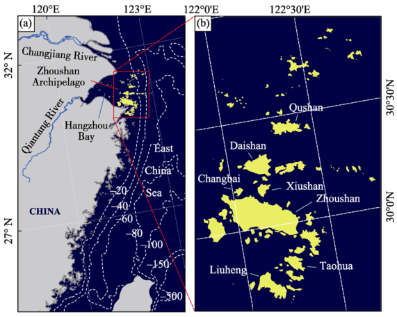
Figure 1 Location of the study area (a) and the major islands of the Zhoushan Archipelago (b)

3 Methods

3.1 Data source

The dataset contained in Xia’s study (2014) is used in the present study. The islands’ area ranges from ~4 to 490,913,910 m2, with an average area of 734,495 m2. For these islands, 2, 18 and 60 islands have their areas of more than 108, 107, and 106 m2, accounting for 44.87%, 86.02% and 95.69% of the total area of the ZA, respectively (Figure 2). Among these, 304 islands are without maximum relief data, and their total area is 401,690 m2, ranging between 10 and 100,710 m2, which occupied about 0.03% of the total area of the ZA. For convenience, the maximum relief of these islands is assumed to be 17.7 m, which is the same as the average value for the islands with the same land area range, based on the dataset. Thus, for all of the islands, the maximum relief ranges from 0.4 to 544.7 m, with an average of 27.7 m. Meanwhile, 2, 23, 80 and 210 islands have a maximum relief larger than 500, 200, 100, and 50 m, respectively (Figure 2). Volcanic rocks are widely distributed in the ZA, accounting for about 80% of the islands’ area, of which extrusive rocks (mainly composed of lava and volcanic clastic rocks) are most widely distributed, followed by crypto volcanic rocks (mainly composed of shallow felsophyre and dacite-porphyrite) (Sha, 2007). Meanwhile, intrusive rocks account for 14% of the areal coverage, and are mainly composed of quartz-diorite, quartz-monzobiorite, monzonitic-granite and granite (Sha, 2007).
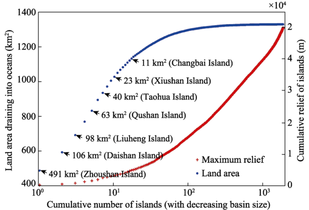
Figure 2 Cumulative area and maximum relief of 1814 islands of the Zhoushan Archipelago in relation to drainage basin size

3.2 Analytical methods

Based on the database of hundreds of globally distributed rivers, a close correlation between sediment load and parameter(s) of basin has been identified. Milliman and Syvitski (1992) pointed out that there is a strong correlation between sediment load and catchment area. Mulder and Syvitski (1996) improved the sediment load-catchment area curve by introducing the maximum relief into the relationship. With considerations of climate zones, Syvitski et al. (2003) suggested that the basin air temperature must affect a river’s sediment flux, which should be also included in the model. Furthermore, Syvitski and Milliman (2007) took into account of the factor of human activities, which led to the establishment of a global predictor of sediment load, i.e., the BQART Model. In this study, the above four models were used to predict the sediment flux of the islands in the ZA. The output values of the four models play a role for mutual validation to overcome the shortcoming of the lack of gauging station records.
For small islands, the maximum reliefs of the different basins are relatively consistent, and the sum of the sediment load of the individual islands is almost equal to a basin with the same maximum relief and catchment area. Therefore, it was assumed that each island in the ZA can be regarded as a single river basin.
In the model (MS1992) proposed by Milliman and Syvitski (1992), sediment load (QS, Mt·yr-1) is a piecewise function of basin area (A, M km2), depending on the maximum elevation range (R, m) of the river basin:
In the Mulder and Syvitski (1996) model (MS1996), QS is an exponential function of basin area (A, km2) and maximum elevation (R, m):
where α is a constant (0.0315) due to unit conversion from kg·s-1 to Mt·yr-1.
In the Syvitski et al. (2003) model (S2003), QS is a function of average discharge, maximum relief and basin-average temperature:
where Q is average discharge (m3·s-1), α = 0.0315 is a constant of proportionality, A is drainage basin area (km2), T is basin-average temperature (16.3℃), and R is maximum relief from sea level to the mountain top (m).
Finally, in the Syvitski and Milliman (2007) model (SM2007), QS is estimated based upon geomorphic and tectonic influences (basin area and relief), geography (temperature, runoff), geology (lithology, ice cover), and human activities (reservoir trapping, soil erosion):
Q=0.075A0.8 (5)
where Q is fluvial discharge (m3·s-1), A is drainage area (km2), and ω = 0.0006 is a constant of proportionality; B = IL(1-TE)Eh accounts for geological and land use factors; I is glacier erosion factor (1 in this case); L is an average basin-wide lithology factor; and TE and Eh account respectively for the trapping efficiency of lakes and man-made reservoirs and human-influenced soil erosion factor, which we assumed to cancel out (Syvitski and Milliman 2007; Nienhuis et al., 2015). Since the basins of the ZA are mainly composed of volcanic rocks (Sha, 2007), we took L = 1 on the basis of Syvitski and Milliman (2007), R as the relief (km) and T = 16.3 as the basin average temperature, for the ZA.

4 Results

Based on the predictive models, QS values for each island in the ZA have been derived, and their statistical characteristics are shown in Figures 3-5. The order of magnitude for QS varies from model to model. Among them, the MS1992 output has the least range, from 102 to 105 t·yr-1, and those of MS1996 and SM2007 have relatively wider ranges, with magnitudes from 100 to 105 t·yr-1. The S2003 output has the widest range, with magnitudes from 100 to 106 t·yr-1.
The different orders of magnitude for QS showed significant variations among the four models. When using the model of MS1992, in terms of the highest frequency of occurrence, 1464 islands have the QS value with the order of magnitude of 103 t·yr-1, whereas for the models of MS1996, S2003 and SM2007, 882, 714 and 1463 islands have the values with the orders of magnitude of 101, 100 and 100 t·yr-1, respectively (Figure 3a). Similarly, the magnitude of a secondary highest frequency of occurrence is 104 t·yr-1 for MS1992, associated with 262 islands, whilst those for the latter three models are 100, 103 and 101 t·yr-1, associated with 533, 428 and 233 islands, respectively (Figure 3a).
In terms of the relative importance, the islands associated with the sediment load that has an order of magnitude of 105 t·yr-1 contribute 42.29% of the total flux, according to the model of S2003. However, for the model of MS1992, MS1996 and SM2007, the islands associated with a magnitude of 104 t·yr-1 are the most important, which account for 44.44%, 53.52% and 42.35% of the total flux, respectively (Figure 3b). In general, for all the models, there are only a few islands that have a QS magnitude of 105 t·yr-1 or higher, but their contribution accounts for 16%-34.80% of the total flux.
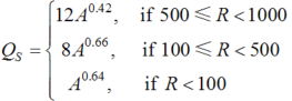
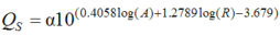
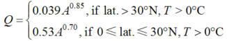
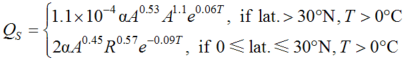
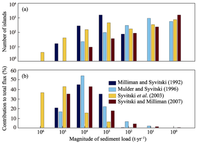
Figure 3 Statistical characteristics of the sediment load (QS) data: (a) the number of the islands associated with different magnitudes of sediment load; and (b) the relationship between the island category represented by the sediment load and the contribution to the total sediment discharge (in percentage) made by the different island categories
The magnitude of QS is closely related to the topographic characteristics (area or/and maximum relief) of the islands (Figure 4). The regional difference in QS is obvious: for the S2003 model, the QS values are larger (i.e., 104-106 t·yr-1) to the south of 30°N, than those to the north of 30°N (i.e., 100-103 t·yr-1) (Figure 4e). For the MS1992, MS1996 and SM2007 models, this difference is reduced to some extent (Figures 4c, 4d, and 4f)
In terms of the total sediment flux, the S2013 output (26.5 Mt·yr-1) represents the largest predicted value, the SM2007 output (~0.7 Mt·yr-1) is the smallest, and the data based on MS1992 (14.4 Mt·yr-1) and MS1996 (1.4 Mt·yr-1) lie in between the two extremes. On average, the sediment flux of the ZA is around 10.7 Mt·yr-1. Meanwhile, the cumulative QS curves show rapid increase on the left side (in terms of either basin size or maximum relief (Figure 5), suggesting that the islands with a large basin area or a maximum relief dominate the total flux of the ZA.
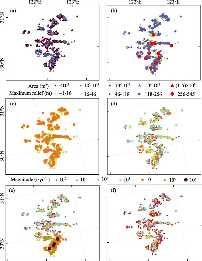
Figure 4 Spatial distribution patterns of island area (a), maximum relief (b), QS predicted by Milliman and Syvitski (1992) model (c), Mulder and Syvitski (1996) model output (d), Syvitski et al., (2003) model output (e), and Syvitski and Milliman (2007) model output (f)
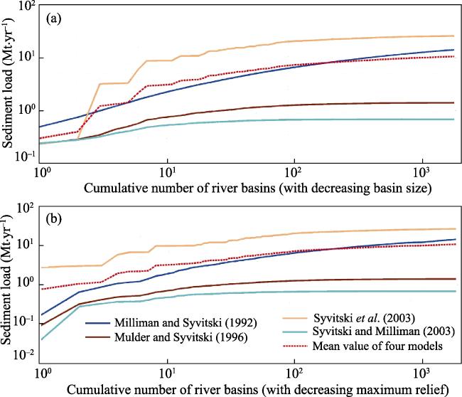
Figure 5 Cumulative sediment load of the Zhoushan Archipelago calculated by the four predictive models

5 Discussion

The information on sediment provenance is fundamental in the interpretations of sedimentary records associated with the Holocene sedimentary systems, especially those of large rivers (Gao et al., 2015). The sedimentary materials supplied by the Changjiang River are the largest source to the CRSS, with a sediment flux of 486 Mt·yr-1 (Milliman et al., 1985) before the building of the many dams in the catchment areas. Compared with the Changjiang River, the sediment supplied by the mountainous rivers along the Zhejiang, Fujian and Taiwan coastlines are also important for the CRSS. In this study, the results from the four models indicate that the QS values of the ZA range from ~0.7 to 26.5 Mt·yr-1, with an average of 10.7 Mt·yr-1. This is at least one order of magnitude lower than those of the Changjiang
River and the Choshui River of the Taiwan Island (30-60 Mt·yr-1) (Liu et al., 2008), but comparable to those of Jiaojiang River (0.8 Mt·yr-1) (Sun and Huang, 1984), Oujiang River (2.7 Mt·yr-1), Minjiang River (7.3 Mt·yr-1) (Compilation Committee of China Bays, 1998), or Qiantang River (7.9 Mt·yr-1) (Su and Wang, 1989) (Figure 6a) in the region. Although the accurate value of this estimate is yet to be verified, there is no doubt that the ZA discharges a considerable amount of sediment into the adjacent shelf waters, both from the drainage basins discharge and/or the erosion of rocky coasts. Thus, more attention should be paid to the evaluation of the ZA sediment input, which is important for understanding any temporal shifts in sediment supply to the CRSS.
A number of publications provide insights into the ZA sediment supply for the adjacent areas. Based on a study on physical and chemical characteristics of the coastal sediments of Putuo Island, Yan et al. (1981) pointed out that here the supertidal, intertidal and even upper part of subtidal areas are mainly composed of gravels, coarse- and fine-grained sands, mostly derived from the erosion of volcanic rocks of this island. A similar result by Li et al. (2002) showed that the weathering products of islands were the main sources of coarse particles of surficial sediments in the Qiqu Archipelago region. Sha (2007) showed that the clastic minerals of the seabed sediments in the ZA sea area are characterized by a quartz-feldspar- hornblende-epidote-flakey mineral-metallic mineral group, indicating that the sediments were derived from adjacent rivers and nearby areas. Moreover, Hu et al. (2009) pointed out that the grain size parameters of surficial sediments are obviously affected by the archipelago, and the bottom sediments generally become finer, well sorted and more negatively skewed with the increasing distance to the islands (Figures 7a, 7b, and 7c). For the Hang zhou Bay, the surficial sediments can be classified into three geochemical provinces (Liu et al., 2012). Province I covers the northern Hangzhou Bay, dominated by suspended sediments derived from the Changjiang River. Sediments from Qiantang River dominate Province II, located in the western Hangzhou Bay. Province III occupies the middle and eastern Hangzhou Bay, which is characterized by relatively high contents of quartz, feldspar and amphibole, and the sediment sources include not only the above two rivers, but also the weathering of the volcanic rocks, i.e., granite and granodiorite. The general pattern is that the coarse sediments derived from the ZA are mainly deposited near the island shorelines, and the fine-grained materials may deposit further away from the shoreline, e.g., in the inner Hangzhou Bay and over the Zhejiang-Fujian coastal seas (Figure 7).
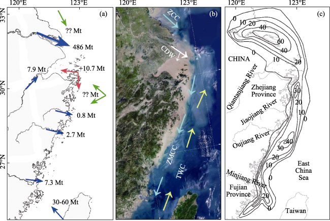
Figure 6 Sediment source and sink patterns of the CRSS: (a) annual sediment supply rates from the various sources; (b) remote sensing imagery (based on Baidu Map (http://map.baidu.com/)), and the major shelf currents (compiled on the basis of Chen (2009)) which affect sediment transport; and (c) isopach map (in meters) of the Changjiang River-dominated deposits formed over the last 7000 years on the inner shelf of the East China Sea (after Liu et al., 2006)
The southward dispersal of fine-grained sediments derived from the Changjiang River contributes to the formation of large areas of mud deposits, in Hangzhou Bay and on the inner shelf off the Zhejiang-Fujian coast (Figure 6). The processes for such southward dispersal are associated with the interaction of tides, waves, the Changjiang Diluted Water (CDW), the China Coastal Current (especially the Zhejiang-Fujian Coastal Currents, ZMCC), winter storms, and the Taiwan Warm Current (TWC) (Su and Wang, 1989; Lin et al., 2005; Liu et al., 2006; Xu et al., 2012) (Figure 6b). Located in the core area of the southward dispersal path of the Changjiang River sediments, the ZA not only supplies additional sediments, but also serves as an obstacle for the sediments to enter Hangzhou Bay and Zhejiang-Fujian coastal seas (Figures 6a, 6b, and 7d). When the suspended sediment plume passes the ZA, the coarse particles is filtered and fine particles may flow through the island areas, a mechanism known as the “archipelago effect” (Hu et al., 2009). Detailed analyses on the sediment budget of the Changjiang River by Wu et al., (2006), Xie et al., (2013), Yang et al., (2015) and Xie et al., (2017) indicate that before the 1980s the net sediment flux across the Luchaogang, Hangzhou Bay and Zhoushan transects were 230, 135 and 85 Mt yr-1, respectively. For the last 30 years, however, the effects of human activities, especially the building of the Three Gorges Dam in 2003, on the sediment load from Changjiang River have changed; the annual sediment discharge decreased from more than 400 Mt yr-1 before the 1980s to below 150 Mt yr-1 after 2003 (Gao and Wang, 2008; Yang et al., 2014). Consequently, the net sediment flux of the first two of the above mentioned three transects decreased to 186 and 122 Mt yr-1, but that of the third one did not change much (Xie et al., 2017). Under such a condition, the sediment supply from the ZA to the adjacent sedimentary systems may become more important than that of the 1980s.
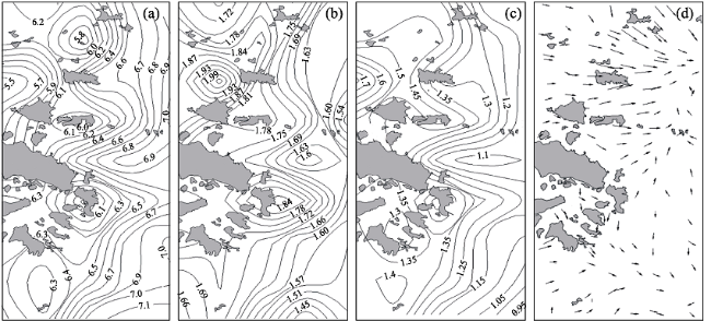
Figure 7 The distribution of mean grain size in φ (a), sorting efficient (b), and skewness (c), and sediment transport pathways of sea-bed sediment (d) in the Zhoushan Archipelago sea area (after Hu et al., 2009)
Based on the sedimentary records of Cores SE1, SE2, DC2 and EC2005 (Zhang, 2014; Xu et al., 2012), the 14C age profiles reveal a significant hiatus at 2 ka BP in the Holocene sequences, and only the upper sections of the deposits are related to the modern Changjiang River (Gao, 2013). A reasonable hypothesis is that the initial bathymetry of the Hangzhou Bay incised valley had a significant influence on the spatial distribution of the sediment discharge from both the Changjiang and Qiantang rivers. With a relatively small flux, the sediments supplied from the Qiantang River were almost entirely deposited to infill the incised valley, in the form of estuarine deposits, which is still an ongoing process nowadays. With the abundant sediment flux from the Changjiang River, rapid infilling took place in the early to middle Holocene periods, i.e., 5 ka BP, and the sediments were deposited mainly in the lower reaches of the Qiantang River and the bay-head areas of the estuary. During the 5-2 ka BP, the sediment started to enter the present-day Changjiang River delta on a large scale; during the last 2000 years, the sediments of the Changjiang River began to escape from the estaurine waters, resulting in accumulation of fine-grained sediment in Hangzhou Bay and on the Zhejiang-Fujian inner shelf (Gao, 2013) (Figure 6c). With a relative smaller sediment flux compared with Changjiang River, the ZA, as mentioned above, has continued to supply sediments to its adjacent regions. If the life scale of the CRSS is taken as 6000 years (Hori et al., 2001), then the total sediment flux of the ZA reaches a quantity of 64.2 Gt. This amount equals to the total amount of sediment load from the Changjiang River for about 130 years. In particular, during the periods when the sediment supply from the Changjiang River was not large, i.e., 6-2 ka BP, the sediments from the ZA would represent a major source to its adjacent sedimentary systems. As such, the ZA sediment supply, when the Holocene temporal scale is taken into consideration, should have certain influence on the growth of the two sedimentary systems mentioned above.
To better understand the role of the ZA in the formulation of the CRSS during the Holocene, future research may focus on the following aspects. (1) Observations of sediment load at key locations in the ZA requires detailed gauging station records or measurements along key transects, against which the sediment flux predicted by existing models can be calibrated. (2) Numerical modeling of sediment transport should be carried out. At present, few numerical experiments associated with the effect of sediment input from the ZA have been undertaken to identify the relevant morphodynamic behavior of the Changjiang River sedimentary system. (3) Comparative studies on the role played by the archipelago in the formation of the sedimentary systems may be conducted for different systems. For instance, similar to the relationship between the ZA and Changjiang River, there are also many islands in the Zhujiang Estuary, from which it can be inferred that relatively large amount of sediment would have yielded during the Holocene. The different evolutionary stages of estuarine infilling, different distribution patterns of islands within the estuarine areas and different dispersal processes and sediment loads (Gao et al., 2015) make the Changjiang River and Zhujiang River sedimentary systems suitable comparable study areas for land-sea-islands interaction studies.

6 Concluding remarks

In this study we investigate the sediment supply from the Zhoushan Archipelago and its influence on the sedimentary systems associated with the Changjiang River. The models proposed by Milliman and Syvitski (1992), Mulder and Syvitski (1996), Syvitski et al., (2003) and Syvitski and Milliman (2007) were used to predict sediment load of the ZA. The estimated total sediment flux of the ZA ranges from ~0.7 to 26.5 Mt·yr-1, with an average value of 10.7 Mt·yr-1. The islands with a larger area or a maximum relief contribute greatly to the total flux of the ZA. This sediment load is an order of magnitude lower than those of the Changjiang and Choshui rivers, but has the same order of magnitude as those of the local Jiaojiang, Oujiang, Minjiang and Qiantang rivers. The ZA not only supplies sediments, but also serves as a geomorphic obstacle to influence the sediment transport into Hangzhou Bay and the Zhejiang-Fujian coastal seas. On a Holocene temporal scale, especially during 6-2 ka BP, the sediments from the ZA had an important effect on the Changjiang River sedimentary systems. Future research should focus on the observations of sediment load and numerical modeling of sediment transport at key locations in the ZA, and comparative studies on different large river sedimentary systems, in order to better understand the role played by an archipelago in the formulation of the sedimentary systems.

The authors have declared that no competing interests exist.

[1]
Baldacchino G, 2016. Archipelago Tourism: Policies and Practices. London: Routledge, 10-20.Archipelago tourism : policies and practices edited by Godfrey Baldacchino (New directions in tourism analysis / series editors, Kevin Meethan, Dimitri Ioannides) Ashgate, c2015 : hbk.

DOI

[2]
Bianchi T S, Allison M A, 2009. Large-river delta-front estuaries as natural “Recorders” of global environmental change.Proceedings of the National Academy of Sciences, 106(20): 8085-8092.Large-river delta-front estuaries (LDE) are important interfaces between continents and the oceans for material fluxes that have a global impact on marine biogeochemistry. In this article, we propose that more emphasis should be placed on LDE in future global climate change research. We will use some of the most anthropogenically altered LDE systems in the world, the Mississippi/Atchafalaya River and the Chinese rivers that enter the Yellow Sea (e.g., Huanghe and Changjiang) as case-studies, to posit that these systems are both "drivers" and "recorders" of natural and anthropogenic environmental change. Specifically, the processes in the LDE can influence ("drive") the flux of particulate and dissolved materials from the continents to the global ocean that can have profound impact on issues such as coastal eutrophication and the development of hypoxic zones. LDE also record in their rapidly accumulating subaerial and subaqueous deltaic sediment deposits environmental changes such as continental-scale trends in climate and land-use in watersheds, frequency and magnitude of cyclonic storms, and sea-level change. The processes that control the transport and transformation of carbon in the active LDE and in the deltaic sediment deposit are also essential to our understanding of carbon sequestration and exchange with the world ocean--an important objective in global change research. U.S. efforts in global change science including the vital role of deltaic systems are emphasized in the North American Carbon Plan (www.carboncyclescience.gov).

DOI PMID

[3]
Blackburn D C, Siler C D, Diesmos A Cet al., 2013. An adaptive radiation of frogs in a Southeast Asian island archipelago.Evolution, 67(9): 2631-2646.Living amphibians exhibit a diversity of ecologies, life histories, and species-rich lineages that offers opportunities for studies of adaptive radiation. We characterize a diverse clade of frogs (Kaloula, Microhylidae) in the Philippine island archipelago as an example of an adaptive radiation into three primary habitat specialists or ecotypes. We use a novel phylogenetic estimate for this clade to evaluate the tempo of lineage accumulation and morphological diversification. Because species-level phylogenetic estimates for Philippine Kaloula are lacking, we employ dense population sampling to determine the appropriate evolutionary lineages for diversification analyses. We explicitly take phylogenetic uncertainty into account when calculating diversification and disparification statistics and fitting models of diversification. Following dispersal to the Philippines from Southeast Asia, Kaloula radiated rapidly into several well-supported clades. Morphological variation within Kaloula is partly explained by ecotype and accumulated at high levels during this radiation, including within ecotypes. We pinpoint an axis of morphospace related directly to climbing and digging behaviors and find patterns of phenotypic evolution suggestive of ecological opportunity with partitioning into distinct habitat specialists. We conclude by discussing the components of phenotypic diversity that are likely important in amphibian adaptive radiations.

DOI PMID

[4]
Bover P, Quintana J, Alcover J A, 2008. Three islands, three worlds: Paleogeography and evolution of the vertebrate fauna from the Balearic Islands.Quaternary International, 182(1): 135-144.The Balearic Islands are an archipelago located in the Western Mediterranean Sea. Their isolation from the mainland allowed the establishment of different faunas on each island. In Mallorca, the Pliocene fauna was composed of the so-called Myotragus-fauna (mainly consisting of a bovid, a glirid and a soricid). In Menorca, it was constituted by the giant rabbit-fauna (mainly consisting of a giant rabbit and a tortoise), and in the Pityusics by a tortoise, a lizard and two rodents. A main faunal turnover took place during the Late Pliocene or Early Pleistocene: the Myotragus-fauna reached Menorca and replaced the giant rabbit fauna. In the Pityusics, all mammals and the tortoise became extinct before the Late Pleistocene for unknown reasons, leaving birds and the lizard as the only vertebrates of these islands. Almost all the endemic vertebrates of the Balearics became extinct probably due to the first human arrival to the islands.

DOI

[5]
Carvajal-ndara S, Hendry A P, Emery N Cet al., 2017. Habitat filtering not dispersal limitation shapes oceanic island floras: Species assembly of the Galápagos archipelago.Ecology Letters, 20(4): 495.Abstract Remote locations, such as oceanic islands, typically harbour relatively few species, some of which go on to generate endemic radiations. Species colonising these locations tend to be a non-random subset from source communities, which is thought to reflect dispersal limitation. However, non-random colonisation could also result from habitat filtering, whereby only a few continental species can become established. We evaluate the imprints of these processes on the Gal谩pagos flora by analysing a comprehensive regional phylogeny for ~ 39 000 species alongside information on dispersal strategies and climatic suitability. We found that habitat filtering was more important than dispersal limitation in determining species composition. This finding may help explain why adaptive radiation is common on oceanic archipelagoes 鈥 because colonising species can be relatively poor dispersers with specific niche requirements. We suggest that the standard assumption that plant communities in remote locations are primarily shaped by dispersal limitation deserves reconsideration.

DOI PMID

[6]
Chen C T A, 2009. Chemical and physical fronts in the Bohai, Yellow and East China seas.Journal of Marine Systems, 78(3): 394-410.These fronts are generally strongest in winter when southward flowing coastal currents are influenced most by winter monsoons, and the contrasts between these cold, fresh, nutrient-rich currents and the northward flowing warm, saline but nutrient-poor Kuroshio are strongest. Surface fronts are generally weakest in summer when coastal currents may be weaker and temperature, salinity and nutrient contrasts are diminished. The existence of fronts and why some are disconnected are mainly related to oceanic features such as topography, boundaries between water masses and current flow patterns. Three latitudinal temperature and nutrient fronts in the southern East China Sea in winter may suggest eastward flowing currents. These currents have not been described previously.

DOI

[7]
Chen J Y, Li C Z, Chongle Zet al., 1990. Geomorphological development and sedimentation in Qiantang Estuary and Hangzhou Bay.Journal of Coastal Research, 6(3): 559-572.The Qiantang Estuary which fronts on Hangzhou Bay is a typical funnel- shaped estuary. It formed under specific geomorphological and hydrological conditions. This article discusses the development processes of the estuary and the large bar that occurs in it. The funnel-shape is a prerequisite for the formation of the bar which conditions the existence of the Hangzhou bore. There is a temporal sequence that extends from the time of the formation of the funnel-shaped estuary through that of the bar to the bore. /// L'estuaire du Qiantang, faisant face a la Baie de Hangzhou, est une estuaire en entonnoir. II s'est form茅 dans des conditions geomorphologiques et hydrodynamiques particulieres. On expose les modalites du processus du developpement de l'estuaire et de son importante barre. La forme en entonnoir est une condition pr^alable a la formation de la barre, laquelle conditionne l'existence du mascaret de Hangzhou. La sequence se de>oule ainsi dans le temps: formation d'un estuaire en entonnoir, d'une barre, d'un mascaret.-Catherine Bressolier (Giomorphologie EPHE, Montrouge, France). /// El estuario de Quiantang frente a la bahia de Hangzhou es el tipico estuario con forma de embudo. Se form茅 bajo unas condiciones geomorfologicas e hidrol茅gicas especificas. Este articulo discute los procesos de desarrollo del estuario y la gran barra que se forma en 茅1. La forma del embudo es un requisito previo para la fomaci贸n de la barra en la entrada de Hangzhou. Hay una secuencia temporal que se extiende desde la formaci贸n del estuario, en forma de embudo, hasta la de la barra en la entrada.-Department of Water Sciences, University ofCantabria, Santander, Spain. /// Der Qiantangastuar, der der Hangzhoubucht gegeniiberliegt, ist ein typischer trichterformiger Astuar. Er bildete sich unter spe-ziellen geomorphologischen und hydrologischen Bedingungen. Dieser Artikel diskutiert die Entwicklungsprozesse des Astuars und der langgestreckten Sandbank, die in ihm auftritt. Die Trichterform ist eine Voraussetzung fur die Entstehung der Sandbank, welche die Hangzhou-Gezeitenwelle bedingt. Es existiert eine zeitliche Abfolge, die sich von der Bildung des trichterformigen Astuars iiber diejenige der Sandbank bis zur Ausbildung der Gezeitenwelle erstreckt.-Helmut Bruckner, Geographisches Institut, Universitdt Dusseldorf, F.R.G.

[8]
Dong Y F, 1991. Grain size features of bed material and sedimentary source in the Hangzhou Bay.Shanghai Geology, 12(3): 22-51. (in Chinese)The distribution of bed material of the Hangzhou Bay is related to sedimentary sources underthe action of current and wave.As a macro-tidal estuary of the Hangzhou Bay,the tidal actionis the major dynamic factor,the grain size of bed material corresponds to the hydrodynamicstrenth.The type of bed material consists of mainly muddy silt and silt.The distributionregularity of bed material is as follows:the grain size is from fine to coarse and its sorti-ng is from poor to good landward from the mouth of bay.The sedimentary sources of Hangzhou Bay come mainly from the sea,among of them,thesediments are transported mainlyfrom the Changjiang estuary into the bay by flood tidal current.

[9]
Fukuta A, Kamimura Y, Hori Met al., 2017. Offshore currents explain the discontinuity of a fish community in the seagrass bed along the Japanese archipelago.Fisheries Oceanography, 26(1): 65-68.Abstract Oceanographic conditions can affect spatial variability in fish community structures by influencing the temperature-dependent latitudinal distribution of adult fishes and transport during their young stages. In order to examine latitudinal variability in the fish community structure within a single coastal ecosystem, quantitative sampling was conducted in the sub-tidal zone of seagrass Zostera marina beds over a broad latitudinal scale (31.31鈥43.0掳N: from subtropical to sub-boreal zones, covering 80% of the latitudinal range of seagrass distribution in Japan) in the western North Pacific based on a uniform methodology. Cluster analysis with the similarity of fish communities showed that 13 sampling sites were divided into two clusters. The border between the two clusters corresponded with the area of mixing of two dominant currents, Oyashio and Kuroshio, which form a border between the warm temperate zone and the cool temperate zone off the Pacific coast of Japan. Oceanographic properties, such as major currents off the coast, are suggested to affect the latitudinal variability in the fish communities in the coastal ecosystem in the western North Pacific.

DOI

[10]
Jackson A M, Erdmann M V, Toha A H Aet al., 2014. Phylogeography of commercial tuna and mackerel in the Indonesian Archipelago.Bulletin of Marine Science, 90(1): 471-492.While numerous population genetics studies have investigated phylogeographic patterns of coral reef organisms in the Coral Triangle, few have addressed whether fishes in the pelagic environment exhibit concordant patterns of genetic subdivision. We analyzed approximately 400 base pairs of the mitochondrial control region to compare population structure and phylogeography of five pelagic tuna and mackerel within a subset of their geographic ranges (i.e., the Indonesian Archipelago). Focal species include frigate tuna [(Lac茅p猫de, 1800)], kawakawa [(Cantor, 1849)], skipjack tuna [(Linnaeus, 1758)], Indian mackerel [(Cuvier, 1816)], and narrow-barred Spanish mackerel [(Lac茅p猫de, 1800)]. Observed patterns of regional genetic subdivision were consistent with the role of Pleistocene vicariance in structuring populations. Divergence dates of all pelagic fish lineages dated to the Pleistocene epoch. Concordant barriers to larval dispersal found near sumatra, sulawesi, and Papua suggested that the Halmahera and Mindanao eddies and the Indonesian flowthrough may be contemporary forces maintaining genetic divergence between demes of pelagic fishes. Given the economic importance of these species, we suggest that the scale of management for pelagics in Indonesia be re-evaluated to reflect regional differences in the genetic composition of fishes.

DOI

[11]
Kurniawan F, Adrianto L, Bengen D Get al., 2016. Vulnerability assessment of small islands to tourism: The case of the Marine Tourism Park of the Gili Matra Islands, Indonesia. Global Ecology and Conservation, 6(C): 308-326.The Indonesian government is currently directing its focus of development on the optimum uses of marine and coastal ecosystem services including the marine and coastal tourism. One of the main locus of coastal and marine tourism is the small islands tourism such as Gili Matra Islands among others. Small islands tourism is one of the favourite touristic activities because the destination provides beauty, exotism, aesthetic and a diversity of natural habitats including the warm, clear and attractive water. Tourism is being considered as a development instrument in order to boost a country鈥檚 economy and has become part of the global industry. However, tourism is also one of the actors that is responsible for environmental depletion, due to the constructions of buildings and tourism activities. This paper aims to study the level of vulnerability in small islands to tourism as a basis of integrated small islands management in Indonesian conservation area. The group of islands in this study consists of three islands namely Gili Ayer Island, Gili Meno Island and Gili Trawangan Island (known as Gili Matra Islands) that were observed using Small Islands Vulnerability Index (SIVI). The results indicate that Gili Matra Islands have a vulnerability status from low into moderate, ranging from 2.25 to 2.75. Gili Ayer Island has the highest vulnerability with SIVI of 2.75 (Moderate), followed by Gili Meno Island with SIVI of 2.50 (Low) and Gili Trawangan Island with SIVI of 2.25 (Low). The driving factor of vulnerability is the intensive utilization of marine tourism activities. Tourism is the sole stress to Gili Matra Island鈥檚 ecosystem due to its direct damaging impact and reducing its environmental quality. The vulnerability index which was built from the coastline, coral reef, live coral reef, and development area was applicable to assess the small island鈥檚 vulnerability in Indonesia, especially for coral island.

DOI

[12]
Gao S, 2013. Holocene shelf-coastal sedimentary systems associated with the Changjiang River: An overview.Acta Oceanologica Sinica, 32(12): 4-12.

DOI

[13]
Gao S, Collins M B, 2014. Holocene sedimentary systems on continental shelves.Marine Geology, 352(3): 268-294.61Holocene continental shelf deposits are related to sediment dynamic processes.61The sedimentary records associated with shelf deposits are high-resolution slices.61Modeling approaches to the formation of sedimentary records can be developed.

DOI

[14]
Gao S, Liu Y, Yang Yet al., 2015. Evolution status of the distal mud deposit associated with the Pearl River, northern South China Sea continental shelf.Journal of Asian Earth Sciences, 114: 562-573.The sedimentary characteristics of distal mud deposits, a product of along shore transport of river-discharged suspended sediment, contain information on their different evolutionary stages. In the present study, the distal mud associated with the Pearl River, southern China, is investigated using the data sets obtained from seabed sediment sample analysis, shallow geophysical survey and 210 Pb dating. The results indicate that although the mud deposit in consideration occupies an area of more than 800002km 2 , the thickness is small with a young age (i.e., <10 2 02yrs). Shallow seismic survey reveals that the Holocene strata have a thickness of around 1002m or less, with the lower layers being characterized by reworked deposits, rather than the distal mud deposits. The internal sedimentary structure shows that clinoforms are poorly developed. Compared with the distal muds of the Yangtze River (on the inner shelf of the East China Sea) and Yellow River (in the northern Yellow Sea), the distal mud here is still at its young stage. In contrast, those associated with the Yangtze and Yellow Rivers have already reached their growing and mature stages, respectively. This difference in the evolution stage is caused by the estuarine processes that control the timing and duration of the distal mud formation. Furthermore, since both river mouth deltas and distal mud deposits, at their mature stage, would be recognized as deltaic deposits in the geological record, it is necessary to establish appropriate criteria that can be used to distinguish between the two types of deposits. They contain different signals of sea level positions; hence, caution should be taken in interpreting the formation of “shelf edge deltas”, which have been found on the outer shelf regions of the South China Sea and in many places elsewhere.

DOI

[15]
Gao S, Wang D, Yang Yet al., 2016. Holocene sedimentary systems on a broad continental shelf with abundant river input: Process-product relationships.Geological Society, London, Special Publications, 429(1): 223-259.Abstract The region consisting of the Bohai, Yellow and East China seas represents a typical wide continental shelf environment with abundant terrestrial sediment supply. Here a variety of sedimentary systems have been formed during the Holocene period. These systems have unique characteristics in terms of spatial distribution, material composition, deposition rate, and the timing and duration for their formation, which are related to active sediment transport processes induced by tides and waves, shelf circulations and sediment gravity flows. The sedimentary records contained within the deposits have a high temporal resolution, but each with a limited temporal coverage. However, if these records are connected, then they may form a complete archive for environmental change studies. In the field of process-product relationship studies, the mid-Holocene coastal deposits on the Jiangsu coast, the early to middle Holocene sequences of the Hangzhou Bay, the Holocene mud deposits off the Zhejiang-Fujian coasts and the other mud areas over the region are of importance. These systems may be understood by identifying the material supply (from both sea bed reworking during the sea level rise events and river discharges), transport-accumulation processes, the formation of sediment sequences and the future evolution of the sediment systems, for which numerical modeling becomes increasingly important.

DOI

[16]
Gao S, Wang Y P, 2008. Changes in material fluxes from the Changjiang River and their implications on the adjoining continental shelf ecosystem.Continental Shelf Research, 28(12): 1490-1500.This study aims to examine the changing patterns of Changjiang material fluxes, which are influenced by anthropogenic activities, and the resultant modifications to the coastal and shelf oceanographic conditions, and to propose future research about the effect of these changes on the estuarine and shelf ecosystem. Within the catchment basin of the Changjiang River, the construction of more than 48,000 dams has caused significant sediment discharge reduction, together with modifications to the timing of seasonal freshwater discharge. In the future, the mean freshwater discharge will decrease following the completion of the water-diverting project for water supply to northern China. At the same time, the riverine nutrient loadings (N and P) have increased due to the extensive use of chemical fertilizers and the large discharge of industrial wastewater and domestic sewage. These changes are modifying the oceanographic conditions of the estuarine and shelf waters. The flushing time for the river water becomes longer in wet seasons but shorter in dry seasons. An increase in salinity can be expected after the completion of the water-diverting project. Nutrient concentrations will be enhanced in the shelf waters. In contrast to the decrease in the suspended sediment concentration of the river water, field measurements have not shown well-defined patterns of changes within the estuary; nevertheless, net sediment accumulation and carbon burial rates would be reduced in the deltaic areas because of the reduced sediment discharge. Finally, increase in the nutrient input appears to enhance the primary production in the East China Sea region, which, in turn, may enhance the fishery catch.

DOI

[17]
Hanebuth T J, Lantzsch H, Nizou J, 2015. Mud depocenters on continental shelves: Appearance, initiation times, and growth dynamics.Geo-Marine Letters, 35(6): 487-503.Mud accumulates on continental shelves under a variety of environmental conditions and results in a diverse formation of mud depocenters (MDCs). Their three-dimensional architectures have been in the...

DOI

[18]
Hori K, Saito Y, Zhao Qet al., 2001. Sedimentary facies of the tide-dominated paleo-Changjiang (Yangtze) estuary during the last transgression.Marine Geology, 177(3): 331-351.The nature of the estuary was very different from other representative tide-dominated estuaries in sediment facies, its distribution, and sediment source for estuarine fill. Unlike the other estuaries that receive sediments mainly from the sea, the paleo-Changjiang estuarine fill deposits were supplied largely from the river. This difference would also have a great influence on the sedimentological and morphological component in the estuary. The sediment distribution of the estuary showed fining-seaward and estuary-mouth sand bodies fed by marine-source sand were absent. The architecture model of tide-dominated estuaries should be divided into two types by the degree of fluvial sediment supply. The paleo-Changjiang estuary shows a good example for an estuary of large rivers.

DOI

[19]
Hu R, Wu J, Li Get al., 2009. Characteristics of sediment transport in the Zhoushan Archipelago sea area.Acta Oceanologica Sinica, 28(5): 116-127.

[20]
Li Y Z, Cheng S L, Gu G C, 2002. Modern sedimentation environment in Qiqu Archipelago.Shanghai Geology, 23(2): 11-16. (in Chinese)The suspended sediments in the Yangtze diluted water and weathering products form islands in Qiqu Archipelago are the main sources surficial sediments in the study area. The major factors controlling the modern sedimentation environment there have topography, tide, the Yangtze diluted water and wind waves. Based on these factors , the study area could be divided four parts, such as outside the archipelago, around the archipilago, inside the main strait of the archipilago and inside the tidal channels beside the main strait. Outside the archipelago, the sedimpentation environment mainly controlled by tidal current, wind waves and the Yangtze diluted water and the surficial sediments mainly consist of clay. Inside the main strait, the sedimentation environment mainly controlled by reciprocation tidal current and the suficial sediments in the west of the strait are coarse and in the east of the deep strait are fine, such as clay and sub - clay, which may be deposited during former period.

[21]
Lin C M, Zhuo H C, Gao S, 2005. Sedimentary facies and evolution in the Qiantang River incised valley, eastern China.Marine Geology, 219(4): 235-259.This paper deals with the sedimentary facies and evolution of the Qiantang River (QR) estuary, and the characteristics and formation of the incised valley sequences and the related shallow biogenic gas reservoir, on the basis of analysis of over 500 cores. The result shows that, since the last glaciation, the Late Quaternary formation of the QR estuary area underwent three stages: (1) deep-cutting stage; (2) rapid-filling stage; and (3) burial stage. The fall of global sea level during the last glacial maximum enhanced the fluvial gradient and river cutting, resulting in the formation of the large-scale QR and Taihu incised valleys, with the interfluve being exposed to air on both flanks of the incised valley. Fluvial terraces at the elevations are present near the present QR estuarine mouth, corresponding to 60鈥70, 90鈥100 and 115鈥125 m burial depths. The valleys were filled rapidly with fluvial sediments during the post-glacial period; with the rise of sea level, the river mouth migrated to landward, and backwater and retrogressive aggradation was enhanced. The QR and Taihu incised valleys are associated with an early filling and transgressive channel-infilling sequence formation, and a late filling and transgressive floodplain-estuary formation. Subsequently, the QR valley was buried under estuarine-marine and estuarine sand bar sediments. From bottom to top, the incised valley successions can be grouped into four sedimentary facies: river channel, floodplain-estuary, estuary-shallow marine, and estuary sand bar. The thickness of the river channel-infilling deposits is controlled mainly by base level rising, backwater, retrogressive aggradation and neotectonism. Further, localized thickening took place where deeper scour pools were present in the incised valley or fluvial terraces were formed during the fall of elative sea level. During the deposition of the floodplain-estuary facies, the conditions of sea level rise, tidal regime, sediment supply and accommodation space were suitable for the development of a tidal ridge system; the sand lenses associated with this facies may represent a tidal ridge system in the incised valley. At the later stage when the estuarine sand bars were formed, the sedimentary conditions were no longer favourable, resulting in absence of sand ridge deposits. Biogenic gas is stored in the floodplain-estuary sand lenses of the incised valleys. The Changjiang River provides the major sediment supply for the QR estuary sand bar, and the QR carried sediments constitute only a small portion of the deposits.

DOI

[22]
Liu J P, Li A C, Xu K Het al., 2006. Sedimentary features of the Yangtze River-derived along-shelf clinoform deposit in the East China Sea.Continental Shelf Research, 26(17): 2141-2156.A predominant sigmoidal clinoform deposit extends from the Yangtze River mouth southwards 800 km along the Chinese coast. This clinoform is thickest (鈭40 m) between the 20 and 30 m isobaths and progressively thins offshore, reaching water depths of 60 and 90 m and distances up to 100 km offshore. Clay mineral, heavy metal, geochemical and grain-size analyses indicate that the Yangtze River is the primary source for this longshore-transported clinoform deposit. 210Pb chronologies show the highest accumulation rates (>3 cm/yr) occur immediately adjacent to the Yangtze subaqueous delta (north of 30 掳N), decreasing southward alongshore and eastward offshore. The interaction of strong tides, waves, the China Coastal Current, winter storms, and offshore upwelling appear to have played important roles in trapping most Yangtze-derived sediment on the inner shelf and transporting it to the south.

DOI

[23]
Liu J P, Liu C S, Xu K Het al., 2008. Flux and fate of small mountainous rivers derived sediments into the Taiwan Strait.Marine Geology, 256(1): 65-76.High-resolution CHIRP sonar profiles across the Taiwan Strait reveal a large silt–sand-dominated deltaic clinoform, up to 50-m thick, overlying the postglacial transgressive sea floor across the southeastern, central, and northern strait. Delta-like configuration and internal depositional sequences indicate a northwestward progradation from western Taiwan, primarily from the Choshui (Zhuoshui) River. Grain-size and mineral data confirm the sediment's Taiwanese derivation. The CHIRP profiles, together with existing radiocarbon and geomagnetic dates, suggest that the clinoform has formed over the past 1002kyr. The estimated volume of 37502km 3 of sediment (mainly sand and silt) suggests a mean annual accumulation of 60 × 10 602t/yr. Presumably much of fine mud delivered by Taiwanese rivers has been washed away by the local currents, and escaped either northeastward into the Southern Okinawa Trough or southward into the South China Sea. Numerous shallow borings onshore over the central western Taiwan coastal plain reveal an additional 35002km 3 of fluvial sediment that has accumulated over the past 1002kyr. The combined onshore–offshore Holocene accumulation, together with an unknown amount of finer sediment that escapes the system, indicates that the long-term sediment flux from Western Taiwanese rivers exceeds 100 × 10 602t/yr, which is not different from the present-day combined annual discharges from the Choshui, Tsengwen, Ehrjen and Wu rivers into the Taiwan Strait.

DOI

[24]
Liu P, Yu Y, Liu C, 1991. Studies on the situation of pollution and countermeasures of control of the oceanic environment in Zhoushan fishing ground: The largest fishing ground in China.Marine Pollution Bulletin, 23: 281-288.Zhoushan fishing ground is located in the eastern part of Hangzhou Bay of China close to the continental seashore of Zhejiang Province and Shanghai Municipality; and links up the Yangtze River, Qiantang River, Yong river and Caoe River. The total length of continental coastline is 1500 km and the total sea area of the fishing ground is about 100,000 km 2 . It is a spawning and growing place for various fishes, shrimps and crabs; and the species of fish are as many as 360 with hairtail, larger yellow croaker, little yellow croaker and cuttlefish well-known throughout the country. The annual catch of fish is about 800 thousand ton, occupying one-third of the national total. However, of the late years, the product of the fishing ground goes straight downwards, and drops by 50% at present. Besides the problem of overfishing, another important factor is the pollution of occanic environment. Coastline is the most developed economic area in China, where the waste water discharged into the sea area of fishing ground comes up to two billion ton causing serious organic pollution and the heavy metals such Cu, Zn, Pb and Cr violating the standards in different degrees and directly affecting the structure and stability of occanic ecosystem, changing the migration route of fishes and the emigration of spawning ground, and the continuous increase of residual toxics in the aquatic products. These problems have brought to the attention of Chinese government; and measures are under way to improve the occanic environmental quality of the fishing ground. The present paper describes in detail the natural conditions and the pollution situation of the fishing ground, and also the contents of studies on the comprehensive programme of environmental protection, including prediction of the developing trend of seawater pollution, the characteristics of ocean current and the route of transference and conversion of petroleum, COD and heavy metals and the receiving capability of sea area for main pollutants; the impact assessment of environmental pollution on the aquatic resources and the countermeasures of oceanic environmental protection.

DOI

[25]
Liu S, Liu Y, Yang Get al., 2012. Distribution of major and trace elements in surface sediments of Hangzhou Bay in China.Acta Oceanologica Sinica, 31(4): 89-100.

DOI

[26]
Milliman J D, Sheng H T, Yang Z Set al., 1985. Transport and deposition of river sediment in the Changjiang estuary and adjacent continental shelf.Continental Shelf Research, 4(1/2): 37-45.Hydrographic observations, suspended-sediment measurements, and historical data indicate transport paths and sinks for sediment within the Changjiang estuary and adjacent shelf. Most of the sediment transported by the Changjiang to the ocean is carried through the North Channel of the South Branch. Sediment transport is directly related to river stage, but tidal phase (spring vs neap tides) also plays an important role. An estimated 40% of the sediment load in the river is deposited in the estuary, mostly in and seaward of the South Channel. The remaining sediment is deposited directly offshore during flood seasons, but much is resuspended and carried southward by subsequent winter storms.

DOI

[27]
Milliman J D, Syvitski J P, 1992. Geomorphic/tectonic control of sediment discharge to the ocean: The importance of small mountainous rivers.The Journal of Geology, 100(5): 525-544.

DOI

[28]
Milliman J D, Farnsworth K L, 2013.River Discharge to the Coastal Ocean: A Global Synthesis. London: Cambridge University Press, 12-35.

[29]
Milliman J D, Farnsworth K L, Albertin C S, 1999. Flux and fate of fluvial sediments leaving large islands in the East Indies.Journal of Sea Research, 41(1/2): 97-107.Because of their generally small drainage basin areas, high topographic relief, relatively young and erodible rocks, and heavy rainfall, rivers draining the high-standing islands of the East Indies transport a disproportionately large amount of sediment to the ocean. Rivers on the islands of Sumatera (Sumatra), Jawa (Java), Borneo, Sulawesi (Celebes), Timor and New Guinea are calculated to discharge about 4.2脳10 t of sediment annually. Although these six islands only account for about 2% of the land area draining into the global ocean, they may be responsible for as much as 20 to 25% of the sediment export. Fluvial sediment leaving these islands is discharged into several distinctly different provinces: shallow epicontinental seas such as the Sunda Shelf, Gulf of Papua and Sea of Arafura; and narrow-shelf, active margins along the western and southern sides of Sumatra and Java, and the north coast of New Guinea. High-resolution seismic profiles in the Gulf of Papua (New Guinea) show a clinoform sequence of Holocene sediments pinching out on the mid- to outer shelf, with sediment thickness locally greater than 40 m near the coast; some 鈥 but perhaps not much 鈥 sediment escapes to the outer shelf and the deeper Papua Trough beyond. In contrast, seismic profiles off northern New Guinea show river-derived sediment prograding over and by-passing a narrow shelf that locally has buried a relict barrier reef. A small fraction of the sediment escaping the northern shelf may be transported to the eastern equatorial Pacific by way of the Equatorial Counter Current, where it may help fertilize equatorial upwelling.

DOI

[30]
Mountz A, 2015. Invisibility and the securitization of migration shaping publics through border enforcement on islands.Cultural Politics, 11(2): 184-200.

DOI

[31]
Mulder T, Syvitski J P M, 1996. Climatic and morphologic relationships of rivers: Implications of sea-level fluctuations on river loads.The Journal of Geology, 104(5): 509-523.The characteristics of 279 rivers that discharge into the world oceans are analyzed in terms of their basin hydrology (river discharge), morphometry (basin slope and area, river length, extension of the continental shelf seaward of the river mouth), and climate (precipitation). Statistically reliable relationships are found between discharge and basin area, and between sediment load and a combined function of basin area and slope. These functions are used to demonstrate how river hydrologic features would be strongly influenced by sea-level fluctuations, particularly under the influence of continental shelf emergence. A fall in sea level toward a glacioeustatic lowstand would induce the merging of rivers on the subaerial continental shelf, thereby allowing giant rivers to form. For example, rivers of western Europe would reorganize themselves into two or three very large rivers. Sediment concentration carried by these mega-rivers would decrease, and thus the number of hyperpycnal plumes generated at river mouths would be reduced. There would, however, be a strong increase in global sediment delivery and thus in the frequency of undrained delta-front failures because of both the progressive concentration of depocenters at the mouths of giant rivers and delta migration toward the shelf breaks. The global increase of sedimentation rate should then be empha-sized at giant river mouths. Associated with a global increase of hypsometry would be a significant increase in the frequency and volume of turbidity currents, since high slopes facilitate flow acceleration and slope erosion.

DOI

[32]
Nienhuis J H, Ashton A D, Giosan L, 2015. What makes a delta wave-dominated?Geology, 43(6): 511-514.River deltas, low-lying landforms that host high concentrations of human population and ecosystem services, face a new, and mostly unknown, future over the coming decades and centuries. Even as some deltas experience decreased sediment supply from damming, others will see increased sediment discharge from land-use changes. There are proposals to actively use riverine sediment supply to build new land and counteract delta loss. We present a novel approach to understanding the morphology of deltas by quantifying the balance between river inputs and the largely overlooked ability of waves to spread sediments along the coast. Defining a fluvial dominance ratio鈥攔iver sediment input versus the potential maximum alongshore sediment transport away from the delta mouth鈥攁llows a quantitative assessment of this sediment transport balance. For a series of deltas on Java, Indonesia, that exhibit a large range of sediment loads but have a homogeneous drainage lithology and wave climate, and for more eclectic global examples, shoreline deflection increases along with this fluvial dominance ratio. The fluvial dominance ratio also predicts the observed transition from cuspate, wave-dominated deltas to fluvially dominated deltas with protruding, crenulated shorelines. Not only does this approach provide a more quantitative foundation for paleoenvironmental reconstructions and delta management, perhaps more importantly, this simple metric of fluvial dominance has a predictive application in determining potential morphology of deltas created by engineered sediment diversions.

DOI

[33]
Ogasawara K, 1994. Neogene paleogeography and marine climate of the Japanese Islands based on shallow-marine molluscs.Palaeogeography, Palaeoclimatology, Palaeoecology, 108(3/4): 335-351.Early Pliocene and Plio-Pleistocene molluscan faunas of Japan and the Northeast Pacific display a remarkable convergence of subtropical and subarctic/cool-temperate realms.

DOI

[34]
Palestini L L, 2016. The territorial and maritime dispute (Nicaragua v. Colombia): On Territorial Sovereignty and the International Court of Justice’s “Failure to Rule” on the geographical scope of the Archipelago of San Andrés. The Law & Practice of International Courts and Tribunals, 15(1): 56-80.Abstract What is the geographical scope of the Archipelago of San Andrés? What are “the other islands, islets and reefs” which, together with Providencia, Santa Catalina and San Andrés, constitute an integral part of this unit according to the 1928 Bárcenas-Esguerra Treaty? While publicists will learn from the 2007 and 2012 Judgments that all the maritime features claimed in the Territorial and Maritime Dispute case are Colombian, they will not find an answer to the question posed by reading those decisions. Indeed, as so eloquently put by Judge Abraham, the Court has “failed to rule” on this matter of treaty interpretation. Yet, the Court could not excuse itself from solving this issue, which was determinative of the territorial dispute, in the present case. Although the Court was right in upholding Colombian sovereignty, its reasoning in this respect is disconcerting. This is why, after having assessed the Court’s methodology, I will provide my own interpretation of the geographical extent of the archipelago. The maritime delimitation effected by the Court will not, however, be analysed.

DOI

[35]
Pan C, Huang W, 2010. Numerical modeling of suspended sediment transport affected by tidal bore in Qiantang Estuary.Journal of Coastal Research, 26(6): 1123-1132.Study of suspended sediment transport in an estuary affected by tidal bore is important for coastal engineering and management because the tidal bore can cause strong sediment resuspension and scour in shallow waters. Numerical modeling of suspended sediment transport in a natural estuary affected by tidal bore is such a challenging research topic that there are few articles on the subject available in the literature. In this study, a two-dimensional, numerical model was developed to investigate suspended sediment transport induced by a tidal bore. The hydrodynamic component of the model employs the Godunov-type scheme with second-order accuracy in space, which effectively describes the rapid supercritical flow and sharp horizontal pressure gradients of the tidal bore. To preserve balance between the source terms and the internal forces, both the water level鈥攂ottom topography formulation (WLTF) method and a special technique for triangular mesh have been applied to solve the source term in the model equations to account for the irregular bottom topography. The wet/dry boundary issue was solved by using the improved exact-Riemann solver on the dry bed. The coupled sediment transport model incorporates more reliable equations from recent publications to characterize the rapid increase of sediment resuspension in the water column. The model test against an analytical solution of convection transport shows that the sharp gradient of scalar transport is satisfactorily estimated in the model simulations. The model in the application has been validated to simulate hydrodynamics and suspended sediment transport affected by a tidal bore in the Qiantang River of China. The results compare well with a time series of observations to characterize the rapid increases of surface elevation, currents, and suspended sediment concentration resulting from the tidal bore. Results of spatial distributions of water levels and currents indicate that the model adequately describes the sharp horizontal gradients of the surface elevation and the tidal currents during the passage of the tidal bore and characterizes the suspended concentrations in the estuary.

DOI

[36]
Sha X G, 2007. Sedimentary characteristics and provenance of the mud sediments in the Zhoushan area of the East China Sea [D]. Changchun: Jilin University, 165. (in Chinese)

[37]
Stankowski S, Johnson M S, 2014. Biogeographic discordance of molecular phylogenetic and phenotypic variation in a continental archipelago radiation of land snails.BMC Evolutionary Biology, 14(1): 2.Background In island archipelagos, where islands have experienced repeated periods of fragmentation and connection through cyclic changes in sea level, complex among-island distributions might reflect...

DOI PMID

[38]
Su J L, Wang K S, 1989. Changjiang river plume and suspended sediment transport in Hangzhou Bay.Continental Shelf Research, 9(1): 93-111.Hangzhou Bay is situated immediately south of the mouth of Changjiang, the fourth largest river in the world in both water and sediment discharge. Synoptic and anchor-station observations of hydrography and suspended sediment during July 1981, December 1982, and December 1983 have been used to describe the water and sediment discharge from Changjiang into Hangzhou Bay. A secondary Changjiang river plume is found to play an important role in both the circulation and sediment transport inside the bay. The plume front serves as a guide for sediment transport and it may be related to the rapid accretion at the south shore of Hangzhou Bay.

DOI

[39]
Sun Y, Huang W S, 1984. The siltation process and silt sources of the Zhejiang coast.Donghai Marine Science, 2(4): 34-42. (in Chinese)Based on historical data of the coast line changes over the years, siltation process of the Zhejiang coast is discussed and four silt sources are clarified. According to analyses of the grain size and mineral and chemical composition of the coastal sediments and data of alongshore currents, dispersion of the fine-grain silt of the Changjiang River emptying into the sea and the fine-grain sediments of the inner shelf are considered as two important silt sources of the siltation.

[40]
Syvitski J P, Peckham S D, Hilberman Ret al., 2003. Predicting the terrestrial flux of sediment to the global ocean: a planetary perspective.Sedimentary Geology, 162(1): 5-24.A new model for predicting the long-term flux of sediment from river basins to the coastal ocean is applied to a global data set of 340 river basins. The model is based on relief, basin area (or, averaged discharge), and basin-averaged temperature. Basin-averaged temperature is determined from basin location (latitude, longitude) and the lapse rate across the basin relief (hypsometric approximation). The sediment flux model incorporates climate through basin temperature and hydrologic runoff. Solutions are provided for each of the major hemispheric climate regions (polar, temperate and tropic). The model successfully predicts the pre-anthropogenic flux of sediment to within the uncertainties associated with the global observations (within a factor of two for 75% of rivers that range across five orders of magnitude in basin area and discharge). Most of the 鈥減roblem鈥 rivers are associated with low observational loads (often smaller rivers where anthropogenic impacts are often magnified, and temporal variability is high). Model predictions provide a baseline for researchers: (1) to question the quality of observational data where available and disagreement is greatest, (2) to examine a river basin for unusually large anthropogenic influences (i.e. causes of erosion or causes of hinterland sediment retention), and (3) to uncover secondary factors not addressed by our model (lithology, lakes). The model provides a powerful tool to address the impact of paleo-climate fluctuations (warmer/colder; wetter/drier) on the impact of sediment flux to the coastal ocean.

DOI

[41]
Syvitski J P M, Milliman J D, 2007. Geology, geography, and human’s battle for dominance over the delivery of fluvial sediment to the coastal ocean.Journal of Geology, 115(1): 1-19.Sediment flux to the coastal zone is conditioned by geomorphic and tectonic influences (basin area and relief), geography (temperature, runoff), geology (lithology, ice cover), and human activities (reservoir trapping, soil erosion). A new model, termed “BQART” in recognition of those factors, accounts for these varied influences. When applied to a database of 488 rivers, the BQART model showed no ensemble over‐ or underprediction, had a bias of just 3% across six orders of magnitude in observational values, and accounted for 96% of the between‐river variation in the long‐term (±30 years) sediment load or yield of these rivers. The geographical range of the 488 rivers covers 63% of the global land surface and is highly representative of global geology, climate, and socioeconomic conditions. Based strictly on geological parameters (basin area, relief, lithology, ice erosion), 65% of the between‐river sediment load is explained. Climatic factors (precipitation and temperature) account for an additional 14% of the variability in global patterns in load. Anthropogenic factors account for an additional 16% of the between‐river loads, although with ever more dams being constructed or decommissioned and socioeconomic conditions and infrastructure in flux, this contribution is temporally variable. The glacial factor currently contributes only 1% of the signal represented by our globally distributed database, but it would be much more important during and just after major glaciations. The BQART model makes possible the quantification of the influencing factors (e.g., climate, basin area, ice cover) within individual basins, to better interpret the terrestrial signal in marine sedimentary records. The BQART model predicts the long‐term flux of sediment delivered by rivers; it does not predict the episodicity (e.g., typhoons, earthquakes) of this delivery.

DOI

[42]
Wang Q, Yu C D, 1992. Development, use and management of the Zhoushan fishing ground, China.Naga, the ICLARM Quarterly, 15(1): 11-15.No abstract is available for this item.

[43]
Wang Y B, Wang Y, 2016. Estimating catches with automatic identification system (AIS) data: A case study of single otter trawl in Zhoushan fishing ground, China.Iranian Journal of Fisheries Sciences, 15(1): 75-90.

[44]
Whittaker R J, Fernández-Palacios J M, 2007. Island Biogeography: Ecology, Evolution, and Conservation. Cambridge: Oxford University Press, 16-90.

[45]
Wu H L, Shen H T, Yan Y Xet al., 2006. Preliminary study on sediment flux into the sea from Changjiang Estuary.Journal of Sediment Research, 12: 6-13.The paper analyzed the relationships of different Depth Datum Levels adopted in different historical nautical charts.By using GIS,DEMs of Changjiang Estuary and Hangzhou Bay were founded as the references of evolution analyses and flux calculations.Based on the great area deposition analyses in the time scale of about a century,combining sediment dynamics and sedimentation method,the paper set up the mode of sediment budget of Changjiang Estuary.According to these results,sediment fluxes for some important cross sections in Changjiang Estuary were calculated.

DOI

[46]
Xia X M, 2014. China’s Islands: Zhejiang (Volume II: Zhoushan Archipelago). Beijing: China Ocean Press, 9-929. (in Chinese)

[47]
Xie D F, Gao S, Wang Z Bet al., 2013. Numerical modeling of tidal currents, sediment transport and morphological evolution in Hangzhou Bay, China.International Journal of Sediment Research, 28(3): 316-328.

DOI

[48]
Xie D F, Pan C H, Wu X Get al., 2017. The variations of sediment transport patterns in the outer Changjiang Estuary and Hangzhou Bay over the last 30 years.Journal of Geophysical Research: Oceans, 122: 2999-3020. doi: 10.1002/2016JC012264.The research objective is to investigate the variations of sediment transport in outer Changjiang Estuary and adjacent Hangzhou Bay, induced by the decline of Changjiang River sediment discharge and massive land reclamation in the last three decades. A synchronous hydrographic survey was conducted along two transects (at the bay-mouth and outer Changjiang Estuary, respectively) during the spring-neap tides of January and July 2014. The results show that the suspended sediment grain size, current velocity, suspended sediment concentration (SSC), and the water and sediment fluxes varied with the tidal cycles. Quantitative correlations with the tidal range were found for SSC and fluxes. These data have been compared with those at the same hydrographic stations in the summer and winter of the early 1980s. Along the outer Changjiang Estuary transect, the SSCs and sediment fluxes decreased in the winter, but no apparent changes occurred in the summer. The SSCs in the northern Hangzhou Bay decreased in both summer and winter, while the southern bay mouth has evolved from a low SSC region to a high SSC region. The findings clarify that the SSC and sediment flux changes in this area have only an indirect connection to the dramatic riverine sediment decline, because the sediment resuspension by the strong tidal currents provided a major source. At the present stage, the impact of the riverine sediment decline is insignificant for the SSC variation off the Changjiang River mouth. Finally, a sediment flux model is proposed to explain and predict the morphological evolution trends.

DOI

[49]
Xu K, Li A, Liu J Pet al., 2012. Provenance, structure, and formation of the mud wedge along inner continental shelf of the East China Sea: A synthesis of the Yangtze dispersal system.Marine Geology, 291: 176-191.78 Sediment along the inner shelf in East China Sea is mainly derived from the Yangtze River. 78 Two depocenters and four acoustic units were found in CHIRP seismic profiles. 78 Yangtze sediment accumulation was unsteady during past 10kyr BP. 78 Two high (8–5 and 2–0kyr BP) and one low (5–2kyr BP) accumulation periods.

DOI

[50]
Yan Q S, Xiang L S, Zhang G Det al., 1981. Modern coastal sediments of Putuo Island, Zhoushan Archipelago.Acta Geologica Sinica, 55(3): 205-214. (in Chinese)Four sub-facies of modern coastel sediments of Putuo Island have been distinguished: sub-facies of the sand dune, supratidal, intertidal and subtidal belts. Each sub-facies is characterized by distinctive surface features, biotic association and sediments with differing composition, texture and structure.It is worth noting that, The water body encircling Putuo Island is strongly influenced by the southward longshore current issuing from the Yangtze River mouth. Tremendous amount of suspended matters, i.e., silt and mud, being carried by the longshore current, become the chief source of modern subtidal sediments around Putuo Island and superficial sediments of the nearby continental shelf. Along the western and southern coasts of the island, where wave energy is low, mud flats have been developed in the main portion of intertidal belt. However, along the eastern and northern coasts of high wave energy, the supertidal, intertidal and even upper part of subtidal flats are mainly composed of gravels, coarse- to fine-grained sands which are caused by erosion of indigenous granitic rocks and basic dykes.As a whole, the grain size of tidal flat of Putuo Island decreases seaward, thus, it differs markedly from that of tidal flats of the North Sea described in the literature.

DOI

[51]
Yang S L, Milliman J D, Xu K Het al., 2014. Downstream sedimentary and geomorphic impacts of the Three Gorges Dam on the Yangtze River.Earth-Science Reviews, 138: 469-486.Although large dams have been constructed and continue to be constructed on many rivers, the lack of long-term gauging data often makes it difficult to document either reservoir sedimentation or the dams' downstream impacts. More than 50years of water and sediment data from 20 gauging stations within the Yangtze River's basin provide us a unique opportunity to delineate the impacts from the Three Gorges Dam (TGD), the world's largest dam. During the first decade after TGD completion in 2003, 1.8Gt of sediments were trapped in the Three Gorges Reservoir (TGR). The TGR's sediment retention rate increased from ~65% during the first three years of operation to ~85% by 2008鈥2012, when the TGD was in normal operation; in the low-discharge drought years of 2006 and 2011, reservoir retention exceeded 90%. Sedimentation in the TGR has been discontinuous, the most prominent depocenters being at the broad section near the up-river entrance to the reservoir and just upstream of the dam, where sediment thickness locally exceeds 60m. Median size of the sediments trapped in the TGR is 11渭m, whereas sediments discharged from the TGR are finer than 5渭m. As a result of sediment retention in the TGR, the river downstream has been eroded at a rate of 65Mt/yr. Riverbed sediments have coarsened considerably in the first several hundred kilometers downstream of TGD. Sediment discharge into the Yangtze estuary, as measured at the Datong downstream gauging station, decreased by 130Mt/yr relative to the normal water years of 2001鈥2002, nearly 90% of which can be attributed to the TGD. With planned construction of large upstream Cascade Reservoirs, the amount of sediment entering the TGR will decline dramatically, thus reducing sedimentation in the TGR and thereby extending its lifespan; by the end of the 21st century, the TGR should have retained more than 80% of its original storage capacity. Sediment outflow from the TGR will likely be less than 15Mt/yr, compared to 50Mt/yr at present. Even with downstream channel erosion, the long-term average sediment discharge into the Yangtze estuary in future decades most likely will decrease to ca. 110Mt/yr, only 20% of its level in the 1960s, and further delta erosion is expected.

DOI

[52]
Yang Y P, Zhang M J, Li Y Tet al., 2015. The variations of suspended sediment concentration in Yangtze River Estuary.Journal of Hydrodynamics, Ser. B, 27(6): 845-856.

DOI

[53]
Zhang Q L, Wang F, Zhao W Het al., 2007. Seasonal characteristics in the water masses in Zhoushan Fishing Ground and adjacent region.Acta Oceanologica Sinica, 29(5): 1-9.The Zhoushan fishing ground is located in the shallowwater area of the northwest East China Sea.The formation and displacement of the fishing ground and variations in fishing season and fish crop are mainly affected by hydrologic conditions and nutrient contents there,whose variations,to a great extent,depend on the occupancy range and vanishing-growing changes in water masses.Using the data observed before the year of 1990,the water masses in the northwest East China sea have been studied by some scientists at home and abroad,but the study on the water mass in this sea area after completion in the three gorges engineering has been not reported so far.In this work,based on CTD and nutrient data obtained during the summer of 2001 and the winter of 2002,the water masses in Zhoushan fishing ground and adjacent region were divided by using the fuzzy clustering method,and the seasonal characteristics in distributions,thermohaline properties and nutrient contents in the water masses in this area were analyzed.The results showed that there are distinct seasonal characteristics in the distributions,ranges,thermohaline property and nutrient contents of the water masses in this area.In the whole study area,there are three water masses,namely,Jiang-Zhe Coastal Water(JCW),Taiwan Warm Current Surface Water(TWCSW) and Yellow Sea(Huanghai Sea) Mixing Water(YSMW) in winter,while there are four water masses,namely,the JCW,the TWCSW,Taiwan Warm Current Deep Water(TWCDW) and the YSMW in summer.The JCW has a relative small occupancy range,low temperature,high salinity and high nutrients in winter;while it has a relative large occupancy range,high temperature,low salinity and low nutrients in summer.The TWCSW extends farther northwards in winter than in summer and its thickness is much larger in winter than in summer.In the TWCSW,temperature is low,salinity is high,SiO3-Si and NO3-N are relative high,and PO4-P is low in winter,while the temperature high,salinity low,SiO3-Si and NO3-N relative low,and PO4-P high in summer.The TWCDW is a seasonal water mass,and there are relative rich nutrients in it.There are some seasonal characteristics in the occupancy range and nutrient contents of the YSMW.

[54]
Zhang X, Lin C M, Dalrymple R Wet al., 2014. Facies architecture and depositional model of a macrotidal incised-valley succession (Qiantang River estuary, eastern China), and differences from other macrotidal systems.Geological Society of America Bulletin, 126(3/4): 499-522.Filling of the modern coastal-zone portion of the Qiantang River (QR) in eastern China was initiated by marine inundation during the transgression after the Last Glacial Maximum and has continued during the Holocene sea-level stillstand. The early part of the fi ll is transgressive in character, while the younger part is regressive. This paper deals with the sedimentary facies, surfaces, architecture, and depositional model of the QR incised-valley fi ll based on the detailed analysis of the newly drilled core SE2 and its correlation with more than 800 boreholes. The incised-valley deposits are grouped into fi ve stacked facies: amalgamated channel, floodplain and channel, paleo-estuary, offshore shallow marine, and present-day estuary. A paleo-estuary facies had never been identifi ed before, making these observations novel. This facies is characterized by a sedimentary succession and sediment distribution that are distinct from those of the present-day estuary because of a change in sediment supply from the sea fl oor beyond the estuary mouth. It also contains large numbers of tidal-channel sand bodies that are signifi cant reservoirs for shallow biogenic gas. Since the last glaciation, there have been three stages in the development of the QR incised-valley fi ll sequence: (1) a formation stage associated with sea-level fall, (2) a fi lling stage during the early transgression with rapid sea-level rise, and (3) a burial stage corresponding to the slowing of sea-level rise and the onset of progradation. This fill consists of four longitudinal segments, each of which is distinguished by a distinct stratigraphic succession and different degrees of marine and fluvial influence. The basal erosion surface and sidewalls of the incised valley, the top of stiff clay on the interfl uves, and the top of falling-stage fluvial-terrace deposits compose the sequence boundary. The initial flooding surface and maximum flooding surface are located with in the amalgamated channel and offshore shallow-marine sediments, respectively. These observations indicate that: (1) relative sea-level changes determine the stratal stacking patterns, but local environmental factors, such as physical processes, accommodation, sediment supply, and coastal confi guration control the nature of the facies, surfaces, and sediment-distribution patterns; and (2) the tripartite facies organization and wave ravinement surfaces typifying wavedominated or mixed-energy (wave and tide) incised-valley fi lls are absent in the macrotidal QR succession, and the tidal ravinement and erosion surfaces of the macrotidal QR incised valley are more extensive and numerous than those of the wave-dominated or mixed-energy succession.

DOI

Outlines

/