Research Articles

Modelling the integrated effects of land use and climate change scenarios on forest ecosystem aboveground biomass, a case study in Taihe County of China

  • WU Zhuo , 1, 2 ,
  • DAI Quansheng , 1 ,
  • GE Quansheng 1 ,
  • XI Weimin 3 ,
  • WANG Xiaofan 1, 2, 4
Expand
  • 1. Key Laboratory of Land Surface Pattern and Simulation, Institute of Geographic Sciences and Natural Resources Research, CAS, Beijing 100101, China
  • 2. University of Chinese Academy of Sciences, Beijing 100049, China
  • 3. Department of Biological and Health Sciences, Texas A&M University, Kingsville, Texas 78363, USA
  • 4. Key Laboratory of Land Use, Ministry of Land and Resources, China Land Surveying and Planning Institute, Beijing 100035, China

Author: Wu Zhuo, PhD Candidate, specialized in climate change and simulation of LUCC. E-mail:

*Corresponding author: Dai Erfu (1972-), PhD and Professor, E-mail:

Received date: 2016-08-30

  Accepted date: 2016-10-09

  Online published: 2017-04-10

Supported by

National Basic Research Program of China (973 Program), No.2015CB452702

National Natural Science Foundation of China, No.41571098, No.41371196, No.41530749

National Key Technology R&D Program, No.2013BAC03B04

Copyright

Journal of Geographical Sciences, All Rights Reserved

Abstract

Global and regional environmental changes such as land use and climate change have significantly integrated and interactive effects on forest. These integrated effects will undoubtedly alter the distribution, function and succession processes of forest ecosystems. In order to adapt to these changes, it is necessary to understand their individual and integrated effects. In this study, we proposed a framework by using coupling models to gain a better understanding of the complex ecological processes. We combined an agent-based model for land use and land cover change (ABM/LUCC), an ecosystem process model (PnET-II), and a forest dynamic landscape model (LANDIS-II) to simulate the change of forest aboveground biomass (AGB) which was driven by land use and climate change factors for the period of 2010-2050 in Taihe County of southern China, where subtropical coniferous plantations dominate. We conducted a series of land use and climate change scenarios to compare the differences in forest AGB. The results show that: (1) land use, including town expansion, deforestation and forest conversion and climate change are likely to influence forest AGB in the near future in Taihe County. (2) Though climate change will make a good contribution to an increase in forest AGB, land use change can result in a rapid decrease in the forest AGB and play a vital role in the integrated simulation. The forest AGB under the integrated scenario decreased by 53.7% (RCP2.6 + land use), 57.2% (RCP4.5 + land use), and 56.9% (RCP8.5 + land use) by 2050, which is in comparison to the results under separate RCPs without land use disturbance. (3) The framework can offer a coupled method to better understand the complex and interactive ecological processes, which may provide some supports for adapting to land use and climate change, improving and optimizing plantation structure and function, and developing measures for sustainable forest management.

Cite this article

WU Zhuo , DAI Quansheng , GE Quansheng , XI Weimin , WANG Xiaofan . Modelling the integrated effects of land use and climate change scenarios on forest ecosystem aboveground biomass, a case study in Taihe County of China[J]. Journal of Geographical Sciences, 2017 , 27(2) : 205 -222 . DOI: 10.1007/s11442-017-1372-x

1 Introduction

Land use and climate change are the two prongs of global change and global ecology, contributing to changes in both local environment and forest ecosystem services (Hansen et al., 2001; Schroter et al., 2005). Multiple human-induced global changes, such as climate change, land use change, deforestation and other global environmental changes are complex and are interacting in the context of a multi-system (e.g., climate system, land system, forest ecosystem). These changes are modifying the atmospheric composition and the land surface’s landscape, resulting in a complex impact on the forest ecosystem (Karl and Trenberth, 2003; Foley et al., 2005). Traditionally, climate, land use, and forest ecological response studies have been operated relatively separately, dealing with specific questions in respective research fields on different space and time scales (Parmesan and Yohe, 2003; Drummond and Loveland, 2010; Rounsevell et al., 2012). However, as research continues, these factors separating studies cannot satisfy the needs of human-earth system coupling and multidisciplinary integrated development, nor can they keep up with the policy makers’ overall planning (Schindler and Hilborn, 2015). Therefore, to better adapt to and mitigate the future global change, it is necessary to explore and anticipate the individual and combined impacts of land use and climate change on forest.
As a result of continued anthropogenic disturbances, climate change has and will continue to affect the forest ecosystem from species to communities, including tree species richness, forest productivity, forest composition and distribution, and forest biomass (Boisvenue and Running, 2006; Bertrand et al., 2011; Michaletz et al., 2014; Dai et al., 2016). Among them, the change of forest biomass is the most significant criterion for evaluating the quality of the forests and has been widely used in the studies of forest ecological responses to climate change and other disturbances (Fearnside, 2000; Mickler et al., 2002). In general, climate change and its impact on forest ecosystems show a long-term process (Payette et al., 1989). Much attention has been focused on the interaction between atmospheric composition changes (e.g., COB2B, N) and the tree species or forest communities (Medlyn et al., 2001; Xu et al., 2007). However, compared with the long-term effects caused by climate change, land use change (such as urbanization, deforestation, farmland expansion and transition, and engineering construction) can bring more direct, short-term effects on forest landscape and forest biomass (Rudel et al., 2005). Due to the complex relationships between forest ecosystem, climate system and land system, it is difficult to explore and predict the key ecosystem characteristics except by going through coarse estimates (Gustafson et al., 2010). In recent years, however, multi-scale and multi-model approaches have provided a new method for some organizations, communities and researchers to deal with these comprehensive issues. For example, global land project (GLP) presented a framework that incorporates human behavior processes in land use and climate system models to quantitatively analyze dynamic changes in terrestrial ecosystems by using agent-based land use and land cover change models (ABM/LUCC) and some dynamic global vegetation models (DGVMs) (Rounsevell et al., 2012). And for another example, the European advanced terrestrial ecosystem analysis and modeling (ATEAM) project proposed using multiple internally consistent scenarios and models to assess the vulnerability of agriculture, forestry, and other human sectors that rely on ecosystem services with respect to global change (Schröter et al., 2004). In terms of more specific issues for forest ecosystems, many studies have also been conducted at the regional or landscape levels. Nepstad et al. (2008) used global circulation models (GCMs), dynamic vegetation models and economic models to explore the interactions among ecosystems, economy and climate to make prospects for a near-term forest tipping point in the Amazon. Thompson et al. (2011) used the LANDIS-II model to evaluate regional forest growth and composition change in Massachusetts, USA over a period of 50 years. They found that, while climate change may enhance growth rates, it will be more than offset by land use, primarily by forest conversion for developed use. ABM has many advantages in simulating land use change and it is designed to integrate human decision processes into a location-specific context in order to explain patterns of land use and test the understanding of land use functions (Matthews et al., 2007). For forest landscape simulation, the LANDIS-II model is a forest disturbance and succession model that can simulate significant ecological characteristics of forested landscapes, such as tree composition, distribution, disturbances, and seed dispersal, as well as the spatial arrangement of aboveground biomass (AGB) (Scheller et al., 2007). Meanwhile, this model was specifically designed to address the effect of land use and climate change on forest landscape (Xu et al., 2007, 2011; 
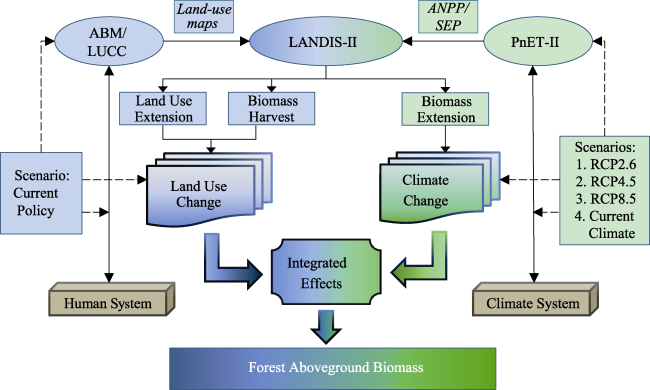
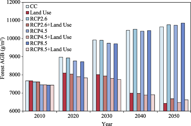
Thompson et al., 2016). Based on the above, we combined an ABM/LUCC model, an ecosystem process model (PnET-II) and the LANDIS-II to simulate and analyze the variations in forest AGB under various land use and climate scenarios.
In southern China, the forested regions are vast, and the plantations are widely distributed in the hilly red soil region, which accounts for 63% of the total area and 62% of the total stocking volume of those in the whole of China (Liu et al., 2014). In the past decades, though the rapid expansion of plantations has made a significant contribution to industrial production and ecosystem services, several issues and challenges always exist, such as unitary tree species, low volumes in growing stock, etc. (Liu et al., 2011). At the same time, the development of plantations is under pressure from both changes. With the acceleration of urbanization and township in China nowadays, the demand for land is increasing and the corresponding climate change will exert intense pressure on the regional forest management (Rudel et al., 2005). In this paper, our objectives were (1) to estimate the land use changes, including the town expansion, deforestation and forest conversion in Taihe County, Jiangxi Province, China, (2) to build a research framework to explore the integrated and relative effects by using simply coupled models, and (3) to simulate the integrated effects of climate change and land use change on forest AGB under various scenarios over the next 40 years from 2010 to 2050. We chose this period for simulation based on following aspects. Firstly, land use changes are greatly influenced by policy which may change with economy, population and other environmental factors. In this study, we chose the relative recent period of 2010-2050 to simulate the land use change. Secondly, this period can also reflect an overall trend of climate change in the near future. So, we chose this period by considering the tradeoff of temporal scale effects between land use and climate change to simulate the integrated effects on forest ecosystem.

2 Materials and methods

2.1 Study area

Our study area is Taihe County (26.45°-26.98°N, 114.95°-115.33°E),which is located in south-central Jiangxi Province, a typical hilly red soil region of southern China (Figure 1). The total area of the study area is 266,700 ha, and the study area is a major component of the Jitai Basin. This area has a subtropical monsoon climate with mild winters (with a mean January temperature of 6.5°C) and warm summers (with a mean July temperature of 29.7°C), and the average annual temperature is 18.6°C. The average annual precipitation is 1370 mm, most of which (approximately 60%) falls between March and June (Wang et al., 2011). The main land use type in the study area includes forest land, town land, farmland, river, and the other land. The total forest area is 163,200 ha, contributing 61.2% to the study area, and the area of plantations is 73,292 ha, which accounts for 44.9% of the total forested area according to forestry resource survey data in Jiangxi Province in 2009. The forests within the study area are comprised of 18 dominant species including: masson pine (Pinus massoniana), slash pine (Pinus elliottii), Chinese fir (Cunninghamia lanceolata), Chinese weeping cypress (Cupressus funebris), camphor tree (Cinnamomum camphora), zhennan (Phoebe zhennan), crenate gugertree (Schima superba), beautiful sweetgum (Liquidambar formosana), Chinese sassafras (Sassafras tzumu), eyer evergreenchinkapin (Castanopsis eyrei), myrsinaleaf oak (Cyclobalanopsis gracilis), fortune chinabells (Alniphyllum fortunei), farges evergreenchinkapin (Castanopsis fargesii), longpeduncled alder (Alnus cremastogyne), faber oak (Quercusfabri), shinybark birch (Betula luminifera), chinaberry (Melia azedarach) and poplar (Populus deltoids). The Qianyanzhou Experiment Station for Comprehensive Development of Natural Resources in the Red Earth Hilly Area (QYZ ecological station, see Figure 1) is also located within our study area.
Figure 1 Location and land use types of Taihe County, Jiangxi Province, China. QYZ station: Qianyanzhou ecological station

2.2 Climate change

The future climatic data were compiled from the projections of 21 climate models in the Coupled Model Intercomparison Project Phase 5 (CMIP5) of the World Climate Research Programme (WCRP) multi-model dataset, which was provided by the National Climate Center of China Meteorological Administration (http://www.climatechange-data.cn). The main climatic factors include monthly mean temperature, monthly maximum temperature, monthly minimum temperature, and monthly precipitation. In this study, the climatic data were under the Representative Concentration Pathways (RCPs) scenarios, including the RCP2.6, RCP4.5 and RCP8.5 scenarios from 2010 to 2050. From the climate prediction dataset, it can be found that the annual mean temperature will have a 1.09-1.73°C increase in our study area in all RCPs scenarios (Figure 2). However, due to the subtropical monsoon climate, the inter-annual variation of precipitation shows a slightly increasing trend and obvious fluctuation from 2010-2050 under various RCPs scenarios. In addition, we designed a control scenario by extrapolating current climate conditions, whereby the temperature and precipitation data were the means of the observations during the last 10 years (2001-2011) from the QYZ ecological station in our study area.
Figure 2 Variation trend of annual mean temperature and precipitation in the study area under RCPs scenarios from 2010 to 2050. (a) annual mean temperature (°C); (b) annual total precipitation (mm) under RCPs scenarios

2.3 Land use change simulation

In our study area, there are mainly four types of land use, including town land, forest land, farmland and other land. The land use data in 1990, 1995, 2000, 2005, and 2010 were obtained from the land and resources survey by the department of land and resources of Jiangxi Province, China. Based on these, we found that the land use types did not change dramatically, and land use changes mainly occurred as town land sprawl and forest land loss. Therefore, farmland and other land were not modeled in the future land use simulation, with their changes depending on the simulated results of forest land and town land. The town land sprawl was of interest in our study, as it had a close relationship with human activities and human decisions. In this study, we used a GIS-based agent based model built by Agent Analyst software. Agent Analyst is an open-source software developed to integrate an ABM development platform - the Recursive Porous Agent Simulation Toolkit (Repast) - within a GIS (ArcGIS). Agent Analyst is a mid-level integration tool that takes advantage of both modeling environments. Specifically, we used the modified and simplified urban growth model to investigate how the behavior of residential household agents affects landscape sprawl for Taihe County. In this model, there is a town center agent placed in the center of Chengjiang Town, which is the center of economy, politics and population in the study area. Residential household agents evaluated the utility by calculating a score for each sample cell’s distance from the town center, the probability of development, and the importance of the resident agent placed on distance and development probability. The utility was calculated from several environmental variables. First of all, the distance from each cell to the town center (tcdist) was selected because the resident agent would give priority to the cells which were close to the town center. Secondly, the development probability for each cell was calculated by evaluating the physical condition and population. In this study, the development of town land use is limited by surroundings. For example, the development has a slope-limiting under 15 degrees, and land use type is not the water body in general. In the meantime, the area that is close to the roads may get a higher probability. We made a buffer of 30 m from the main roads, which have a higher development probability of town land use. In addition, the population in different zones had been considered. The population of different administrative division of the town units was standardized. These variables above, including slope, roads, and population, were weighted them equally and were overlaid to a map of development probability (devpro). Finally, we assumed that all the resident agents had the equal preference on the distance and development probability. This method can simplify the model code, as well as achieve our study objectives more directly. As a result, the agents may prefer cells that are closer to the town center and have a higher development probability. The utility formula is shown in Eq. 1:
\[\ Utility=(1-|\beta_p-devpro|^{\alpha_p})\times (1-|\beta_d-tcdist|^{\alpha_d})\ \ (1)\]
where devpro stands for the development probability, tcdist stands for the distance from each cell to the town center; βBdB represents that the resident agents prefer the cells closer to the town center, βBpB means that they prefer a higher development probability. Here, βBdB, βBpB=1. The importance resident agents place on development probability (αBp) and the distance to the town center (αBdB), αBpB + αBdB = 1. For the sake of simplicity code, all resident agents have the same utility function and parameter values in this model. In terms of the inputs of the model, the land use map and the development probability map take the form of raster maps with a 100-m resolution. The initial land use map is the rasterized land use data from 2010. The development probability map is calculated by some limiting factors, as shown in Eq. 2:
Development probability=f(αp swr) (2)
where αBpB stands for the standardized population in respective administrative towns in Taihe County, and βBsB stands for the slope. In this study, we limited the developed cells’ slope to less than 15 degrees. When the slope is above 15 degrees, the development probability is set to zero; γBwB stands for the water body area, which is also defined as undeveloped area and the development probability set to 0. λBrB stands for the buffer of the roads, which is frequently affected by human activities, and the probability is set to 0.8. The development probability is within the range of 0-1, and the development probability map is shown in Figure 3.
Figure 3 The map of development probability for resident agents to settle, where 0.0 means no development at all and 1.0 means full development
Based on the overall plans for land use in Taihe County from 2006 to 2020, we determined how many cells to develop for the resident agents in the future simulation. The overall plan for land use in part reflects the land use change policy in the near future, which indicates the choice tendency of the local government. The overall plan has a binding effect and a guiding function on the implementation of land use policies. Especially in China, the land use plan has a more profound effect and the local government plays a predominant role in the process of land use. Therefore, the land use plan data is relatively reliable to use as the basic data for the model in our study. The area of town land was 14,773 ha in 2010, and the total town planning area will reach 17,173 ha in 2020 according to the overall plan goal. Accordingly, about 240 new cells were selected at each time step (one year) for the resident agents to settle in and turn into town land. In this study, we assumed that the land use policy and developing rate will sustain and extrapolate current conditions in the coming decades up until 2050.
For deforestation and forest conversion modeling, we used the land use extension and biomass harvest extension from the LANDIS-II model. Land use extension can incorporate a sequence of maps depicting land use or land cover change into LANDIS-II simulations. Maps were developed from the output of the urban sprawl model in Agent Analyst. With this extension, the model can simulate how cohorts will be removed if changes in the land use or land cover results in forest loss. In addition, land use extension is integrated into the biomass harvest extension, resulting in corresponding land use and AGB changes. The harvest experiment in the simulation was designed to match the current forest management policy, which keeps ten percent for different forest management area at each time step (ten years) for the LANDIS-II model.

2.4 Forest AGB simulation

In this study, we used LANDIS-II and PnET-II to conduct the simulation of forest AGB. The LANDIS-II model is a cell-based spatially dynamic forest landscape model of disturbance, succession and management (Scheller et al., 2007). It can simulate forest dynamics by tracking the changes in species age cohorts, which is driven by species life history attributes, species establishment probability (SEP), maximum aboveground net primary production (ANPP), and spatial heterogeneity (Mladenoff and He, 1999). LANDIS-II is specifically designed to address the effects of climate change on forests and has been widely applied in analyzing complex interactions (Scheller and Mladenoff, 2005; Xu et al., 2009). In this study, we used the LANDIS-II model with the biomass succession extension, land use extension, and biomass harvest extension. With these extensions, LANDIS-II can address climate change and land use change effects on forest AGB (Gustafson et al., 2010; Thompson et al., 2011). The main inputs for LANDIS-II include spatial inputs (initial species maps, ecoregion maps and land use maps) and non-spatial inputs (species life history attributes, ANPP and SEP). The initial species map was derived from forestry resource survey data by the sub-compartment division of Jiangxi Province in 2009. The ecoregions map was divided into five ecoregions, four forested regions and one non-forested region, which were based on relatively homogeneous geomorphic forms (Figure 4). The parameters of the species life history attributes were mainly compiled from literature, plot investigation and consultations with local forestry experts (Chen et al., 1996; ECFC, 2000) (Table 1).
Figure 4 Ecoregions of the study area. Ecoregion 1 is non-forestland and un-active in our simulation. Ecoregions 2 to 5 stand for low hills (under 100 m), medium hills (100-250 m), high hills (250-500 m) and mountains (above 500 m), respectively
The ANPP and SEP for each species were derived from the PnET-II model. The PnET-II is a process based model for carbon and water balance in forest ecosystems (Aber and Federer, 1992). It can simulate the effect of climate change on forest photosynthesis by applying adjustable factors, including light, temperature, water availability, water vapor deficit and COB2B concentration (Xu et al., 2009). In this study, we applied version 5.1 of the PnET-II model to calculate the ANPP and SEP of 18 tree species under RCPs and a control scenario. The most primary parameters in PnET-II, such as the water-holding capacity (WHC) and photosynthetically active radiation (PAR), were based on observation in the QYZ ecological station. The other parameters were obtained from literature published for this area, including foliar nitrogen concentration (FolNCon) (Yu et al., 2014), minimum temperature for photosynthesis (PsnTMin) (Wu, 1984), optimum temperature for photosynthesis (PsnTOpt) (ECECA, 1989), and water use efficiency (WUE) (Sheng et al., 2011).

2.5 Modelling framework

To explore the integrated and relative effects of land use and climate change on forest AGB, we simply coupled the ABM/LUCC model, the PnET-II model and the LANDIS-II to build a framework and to combine the human system and the climate system (Figure 5). Firstly, we used the ABM/LUCC model to simulate the development of town land under the current land use policy. A series of land use maps were created from the output of the ABM model, as well as the input for land use extension for LANDIS-II. Secondly, we used the PnET-II model to calculate the ANPP and SEP for tree species under various climate scenarios, including RCP2.6, RCP4.5, RCP8.5, and a current climate (CC) scenario, as well as the inputs for the biomass succession extension of LANDIS-II. Finally, the LANDIS-II model was used as the core of the framework to simulate the forest AGB change under the pressure of human and climate factors. This framework offers a coupled method to better understand the interaction of ecological processes, and it may give some supports for improving and optimizing the plantations’ structure and function.
Table 1 Species life history attributes in Taihe County, Jiangxi Province, China
Species Common name Longevity
(year)
Sexual maturity
(year)
Shade tol. Seed dispersal dist.
Effective (m) Maximum (m)
Cunninghamia lanceolata Chinese fir 200 10 1 200 500
Cupressus funebris Chinese weeping cypress 500 35 2 70 200
Pinus massoniana Masson pine 200 10 1 200 500
Pinus elliottii Slash pine 200 10 1 200 500
Schima superba Crenate gugertree 300 20 5 20 200
Cinnamomum camphora Camphor tree 1000 15 4 50 120
Phoebe zhennan Zhennan 1000 50 5 40 120
Castanopsis eyrei Eyer evergreenchinkapin 200 20 5 50 120
Castanopsis fargesii Farges evergreenchinkapin 150 30 5 60 250
Quercus fabri Faber oak 120 15 4 20 200
Cyclobalanopsis gracilis Myrsinaleaf oak 200 7 4 20 50
Liquidambar formosana Beautiful sweetgum 130 8 3 100 375
Betula luminifera Shinybark birch 100 15 2 150 400
Alnus cremastogyne Longpeduncled alder 125 5 3 15 60
Alniphyllum fortunei Fortune Chinabells 120 15 2 250 500
Sassafras tzumu Chinese sassafras 120 20 3 50 150
Melia azedarach Chinaberry 80 5 2 200 400
Populusdeltoids Poplar 90 10 2 150 500

Notes: Shade tol. stands for the species’ tolerance to shade. The value is an integer between 1and 5, where 1 means the least tolerance and 5 means the most tolerance. Seed dispersal dist. stands for the species’ effective or maximum distance for dispersing seeds.

Figure 5 The framework for the integrated effects of land use and climate change on forest AGB

3 Results

3.1 Land use change modelling

The results of the town land change under the ABM/LUCC model is shown in Figure 6. In this section, we are only interested in the town land sprawl, so the output maps are shown as town land over the upcoming 40 years. The results show area percentages of town land in 2020, 2030, 2040 and 2050 account for 6.4%, 7.3%, 8.2% and 9.0% of the total area, respectively. Rapid town land expansion is built on the current town center, which forms an overall sprawling trend of the town center into the surrounding area. The development of town land occurs in Chengjiang Town, which has the highest population in Taihe County. In addition, the results show that urban and town fringe is the transition belt, which is the most active portion of the town land sprawl process. The spatial pattern of the town land development reflects the rules and behaviors of the decision-making of the resident agents. They prefer to settle in areas closer to the town center.
Figure 6 The results of town land change from the ABM/LUCC model

3.2 ANPP

The ANPP from the PnET-II model is an important parameter and offers important input for forest AGB calculation in the LANDIS-II model. Therefore, the ANPP change is of interest in this section and the ANPP change for the 18 tree species under the three RCPs scenarios is shown in Figure 7. The ANPP under the current climate scenario is unchanged during the simulation, so the results were not shown here. The mean values of the ANPP are calculated from the mean values in four active ecoregions from ecoregion 2 to 5. The results of the simulation show that the overall trend of the ANPP for all species increases during 2010-2050, and the ANPP of broad-leaved species is significantly higher than that of coniferous species. Under different climate change scenarios, the variation in the ANPP shows a significant difference between species, especially for certain broad-leaved species, such as crenate gugertree, eyer evergreenchinkapin and farges evergreenchinkapin. Under the RCP2.6 scenario, the range of the ANPP for all species is 489 g mP-2P·yrP-1P (Chinese weeping cypress) to 1043 g mP-2P·yrP-1P (eyer evergreenchinkapin). By 2050, the percentage of the increase for each species is in the range of 5.7% (Chinese fir) to 12.5% (eyer evergreenchinkapin). Under RCP4.5 scenario, the range of the ANPP for all species is 483 g mP-2P·yrP-1P (Chinese weeping cypress) to 1097 g mP-2P·yrP-1P (eyer evergreenchinkapin). By 2050, the percentage of increase for each species is in the range of 7.7% (Chinese fir) to 23.4% (eyer evergreenchinkapin). Under the RCP8.5 scenario, the range of the ANPP for all species is 483 g mP-2P·yrP-1P (Chinese weeping cypress) to 1143 g mP-2P·yrP-1P (eyer evergreenchinkapin). By 2050, the percentage of increase for each species is in the range of 6.9% (Chinese fir) to 26.5% (eyer evergreenchinkapin). The forest AGB is influenced by many factors, such as ANPP, spatial distribution and SEP. The variation on ANPP is the dominant factor to affect the forest biomass, reflecting the AGB accumulation rate for different species. In terms of 18 species in our study area, the rate of change for each species from 2010 to 2050 was selected to show the effect of ANPP on forest AGB. The main tree species includes eyer evergreenchinkapin, chinaberry, longpeduncled alder, shinybark birch, faber oak and camphor tree. The effect degree of ANPP on forest AGB for these tree species gradually increase under RCP2.6, RCP4.5 and RCP8.5 scenarios.
Figure 7 Aboveground net primary production (ANPP) for 18 species simulated by PnET-II under RCPs scenarios. (a) RCP2.6; (b) RCP4.5; (c) RCP8.5

3.3 Forest AGB

In order to ensure that the simulated result of forest AGB is relatively correct, we first compared the simulated and investigated values with the first year in order to validate the LANDIS-II simulation results.The investigated values come from the observational stand volume at each forest sub-compartment from the forestry inventory data. The method for converting between AGB and stock volume is referenced from Fang et al. (2001). The biomass expansion factor (BEF) was calculated as a function of stand timber volume (x), BEF = a + b/x, where a and b are constants for a specific forest type (Fang et al., 2001). These variables for specific species were obtained through field measurements and from previous studies in the area (Wu et al., 2011). Specifically, five hundred sub-compartments were randomly selected as the verification points, which were based on the distribution of the main species in our study area (Figure 8a). The results showed a positive linear correlation between the simulated and investigated values (RP2P=0.6463, p<0.001), which indicated that the method’s feasibility and the simulation results can be considered reliable (Figure 8b).
Figure 8 Spatial distribution of the points for model validation and the comparison between simulated and investigated values of forest AGB
The forest AGB of the different tree species simulated by the LANDIS-II model under various scenarios is shown in Figure 9. The results show that all the forest AGB increase under the CC, RCP2.6, RCP4.5 and RCP8.5 scenarios from 2010 to 2050 (shown as the blue histogram in Figure 9). However, the results of the forest AGB show initial increase and then decrease under all land use and integrated scenarios (shown as the red histogram in Figure 9). As to the climate change, variation in the AGB shows a difference between various climate scenarios. By 2050, the forest AGB under CC, RCP2.6, RCP4.5 and RCP8.5 increases by 2965.9 g mP2P, 3163.1 g mP2P, 3281.1 g mP2P and 3416.4 g mP2P, respectively. As to the isolated effect of land use, the forest AGB increases to 8109.3 g mP2P in 2020, then decreases to 6441.2 g mP2P by 2050 only under the land use scenario. In terms of the integrated effect of land use and climate change, the results show an increase first, and then show a decreasing trend after 2020 under land use that is integrated with RCPs scenarios. When compared to the results under separate RCPs without land use disturbance, the forest AGB under the integrated scenario decreases by 53.7% (RCP2.6+land use), 57.2% (RCP4.5+land use), and 56.9% (RCP 8.5+land use), respectively by 2050. Land use change plays a vital role in the integrated simulation. It has a more significant effect on forest AGB than climate change, and this effect will become more noticeable as the simulation time progresses.
Figure 9 Forest AGB of the total forest area under various scenarios. CC: current climate scenario

4 Discussion

4.1 Results interpretation

Our results suggest that land use and climate change is likely to significantly change forest AGB in our study area under various scenarios. Land use change, including town sprawl and harvest, makes a great contribution to the integrated effects and becomes the dominant factor in the simulation. These simulation results show consistence with the results of Thompson et al. (2011) and Gustafson et al. (2010). Thompson et al. (2011) found in Massachusetts, USA, while climate change may enhance growth rates, this will be more than offset by land use. Gustafson et al. (2010) also found that the direct effects of climate change in south-central Siberia are not as significant as timber harvest and other disturbances. For the simulation results of land use change, primarily forest conversion is the town land sprawl. We used the simplified ABM/LUCC model to simulate this conversion process of land use. The results help to specify the behavioral rules of individuals, identify the situations in which the agents reside, and determine possible outcomes according to the appropriate contexts. From an object-oriented point of view, these resident agents are self-directed objects, and their evaluation of the utility of the landscape location will influence their actions. The environmental factor is also an important contributor to ABM in this study. This method can directly represent the interior driving factors of land use change. According to our results, population and the physical environment are the two main factors that influence the agents’ decisions. For the ANPP results, we found that forest productivity increased with temperature and precipitation in the subtropical monsoon climate zone under RCPs, which shows consistence with the result of Mi et al. (2008). Except for temperature and precipitation, change in other environmental factors also leads to ANPP change. For example, the changing atmospheric concentrations, such as COB2B (Wittig et al., 2005), OB3B (Cojocariu et al., 2005) and N (Huang et al., 2014), may also affect forest productivity. In our study, we incorporated the effect of COB2B concentrations on the stomata conductance of different species. However, we did not consider the effects of COB2B fertilization on ANPP.
During simulation, the forest AGB accumulation is calculated by the ecosystem process rates and the quantity of aboveground living biomass for each tree species-age cohort without regard to disturbances (Scheller and Mladenoff, 2004). The biomass module conducted three process rates, ANPP, aboveground mortality, and woody biomass decomposition (Scheller and Mladenoff, 2005). These critical calculations and assumptions can help to implement the coarse simulation at the forest landscape scale (Scheller et al., 2007). As to the disturbances in our simulation, they are land use change (primarily town land sprawl and forest transition), climate change (primarily temperature and precipitation) and forest harvest (biomass removal). In the simulation, the biomass accumulation has a positive correlation with the increase of temperature and precipitation, irrespective of the land use change. This increasing trend of AGB is consistent with the results of Wu et al. (2011). Under all land use scenarios, the total forest AGB first experiences a slight increase and then quickly decreases. Forest transition and tree species removal that is caused by town land sprawl, and by plantation timber harvest done every ten years have resulted in a sharp decrease in the total forest AGB. These human-induced actions can result in even more direct influence on the forest AGB than climate change and biomass accumulation.

4.2 Uncertainties and limitations of simulating the integrated effects

Land, climate and forest are interacting and are in the process of mutual restraint in the multisystem. Land system change is mainly caused by anthropogenic activity, which is accompanied by a series of forest landscape changes, including forest transitions, deforestation, forest conversion and reforestation (Rudel et al., 2005). Climate system change is also affected by anthropogenic activity and land use change, and it has effect and feedback mechanisms involved with the forest and the climate (Karl and Trenberth, 2003). For the forest ecosystem, spatial interactive processes, succession, disturbances, migration and transition occurred simultaneously (Hansen et al., 2001; Cottenie, 2005). Therefore, it is difficult to study longtime successive responses of this integrated effect on the forest at the landscape scale.
In this study, we offer a framework to explore the integrated and relative effects by using some simply coupled models. This framework can help us to assemble the models for different systems to conduct the integrated effects on forests, and to gain a better understanding of the complex, interacting ecological processes. However, there are also uncertainties and limitations of simulating the integrated effects in our study. Firstly, uncertainties exist in the data and in the parameterization process, which is limited by the available data and the literature. For climate data, the RCPs dataset resulting from the multi-model ensemble is still an important issue, though it is more acceptable than a single model (Tebaldi and Knutti, 2007). In addition, the accuracy of climate data is hard to obtain by spatial resolution at the regional and landscape scale. As to parameterization for the PnET-II and LANDIS-II, a large amount of tree species life history parameters may potentially arouse some uncertainty in the simulation. Even though these uncertainties and limitations are inevitable in the simulation process, our results are still credible based on the forestry survey data, plot investigation, model validation, and consultation with local forestry experts. Secondly, the limitations in the simulation were derived from the models. In this study, we used the highly simplified ABM/LUCC model. ABM is based on the complexity theory and can represent feedback in multilevel systems where the higher and lower levels simultaneously influence and limit one another (Yu et al., 2011). Meanwhile, the agents in the modeling are intelligent, so they can be influenced by the environment and by changes in the behavior of other agents. In order to simplify the code in the Agent Analyst and easily achieve our goals, we only concentrated on the resident agents and the town land change. The humans are the main actors in land use and other activities, and they are as well as the main sources of uncertainty in the simulation. The selection mechanism of human activities to land use will change with the physical condition and the relationship between different agents. In our study, we ignored some complex interaction process between agents which may lead to some uncertainty. However, this method can bring some conveniences for modeling in turn, and can make our study objectives to be achieved. The future studies should be improved to reduce uncertainty. (1) Differences of agent types should be considered to simulate the real world as much as possible. The main agent types should be selected depending on the specific research goals. (2) The key selection activities of different agents should be screened based on the research goals. We should consider the interaction and mutual influence between the agents. (3) The environmental and economic factors will change over time. This point should also be included and the extreme events can be added in the future simulation. (4) We should build the agent’s self-learning mechanism according to the change of the agents and the environment, so as to find a balance between the reality and simulation to reduce uncertainty. For the other ecological models, the PnET-II and LANID-II models are also the simplifications of complex ecosystem processes. In terms of LANDIS-II, the model simulates broad spatial and long temporal scale dynamics for cells that incorporate species not with individual stems but with cohorts (Scheller et al., 2007). Finally, the coupled simulation that dealt with the integrated effects was based on some reasonable assumptions. For example, the species life-history attribute parameters and the landscape heterogeneity (e.g. landform, soil texture hydrologic conditions and phenology) would not change with time. Moreover, although the RCPs scenarios were developed from human activities like land use effect, we assumed that land use change was not affected by climate change, which could lead to some uncertainties in the simulation. Though there are cumulative uncertainties and limitations in simulating the integrated effects, we considered these to be trade-offs between the technical and ecological insights. Our objective is not to predict the forest biomass precisely in the near future, but to explore the change of forest landscape under multiple factors, which is a new exploration for the comprehensive simulation. This framework has scientific significance in the study of the effect of land use and climate change on forest landscape.

5 Conclusions

From our study we can draw the following conclusions. (1) Land use (including town expansion, deforestation and forest conversion) and climate change are likely to influence forest AGB in the near future in Taihe County. (2) Though climate change will make a good contribution to the forest AGB increase, land use change can result in a rapid decrease in the forest AGB and play a vital role in the integrated simulation. Under the integrated scenario, forest AGB decreased by 53.7% (RCP2.6+land use), 57.2% (RCP4.5+land use), and 56.9% (RCP8.5+land use) by 2050, which is in comparison to the results under separate RCPs. (3) The framework for simulating the integrated effects on forest AGB can offer a coupled method to gain a better understanding of the complex, interacting ecological processes.

The authors have declared that no competing interests exist.

[1]
Aber J D, Federer C A, 1992. A generalized, lumped-parameter model of photosynthesis, evapotranspiration and net primary production in temperate and boreal forest ecosystems.Oecologia, 92: 463-474.PnET is a simple, lumped-parameter, monthlytime-step model of carbon and water balances of forests built on two principal relationships: 1) maximum photosynthetic rate is a function of foliar nitrogen concentration, and 2) stomatal conductance is a function of realized photosynthetic rate. Monthyly leaf area display and carbon and water balances are predicted by combining these with standard equations describing light attenuation in canopies and photosynthetic response to diminishing radiation intensity, along with effects of soil water stress and vapor pressure deficit (VPD). PnET has been validated against field data from 10 well-studied temperate and boreal forest ecosystems, supporting our central hypothesis that aggregation of climatic data to the monthly scale and biological data such as foliar characteristics to the ecosystem level does not cause a significant loss of information relative to long-term, mean ecosystem responses. Sensitivity analyses reveal a diversity of responses among systems to identical alterations in climatic drivers. This suggests that great care should be used in developing generalizations as to how forests will respond to a changing climate. Also critical is the degree to which the temperature responses of photosynthesis and respiration might acclimate to changes in mean temperatures at decadal time scales. An extreme climate change simulation (+3掳 C maximum temperature, 鈭25% precipitation with no change in minimum temperature or radiation, direct effects of increased atmospheric CO 2 ignored) suggests that major increases in water stress, and reductions in biomass production (net carbon gain) and water yield would follow such a change.

DOI PMID

[2]
Bertrand R, Lenoir J, Piedallu C,et al.., 2011. Changes in plant community composition lag behind climate warming in lowland forests.Nature, 479: 517-520.Abstract Climate change is driving latitudinal and altitudinal shifts in species distribution worldwide, leading to novel species assemblages. Lags between these biotic responses and contemporary climate changes have been reported for plants and animals. Theoretically, the magnitude of these lags should be greatest in lowland areas, where the velocity of climate change is expected to be much greater than that in highland areas. We compared temperature trends to temperatures reconstructed from plant assemblages (observed in 76,634 surveys) over a 44-year period in France (1965-2008). Here we report that forest plant communities had responded to 0.54 掳C of the effective increase of 1.07 掳C in highland areas (500-2,600 m above sea level), while they had responded to only 0.02 掳C of the 1.11 掳C warming trend in lowland areas. There was a larger temperature lag (by 3.1 times) between the climate and plant community composition in lowland forests than in highland forests. The explanation of such disparity lies in the following properties of lowland, as compared to highland, forests: the higher proportion of species with greater ability for local persistence as the climate warms, the reduced opportunity for short-distance escapes, and the greater habitat fragmentation. Although mountains are currently considered to be among the ecosystems most threatened by climate change (owing to mountaintop extinction), the current inertia of plant communities in lowland forests should also be noted, as it could lead to lowland biotic attrition. 漏2011 Macmillan Publishers Limited. All rights reserved

DOI PMID

[3]
Boisvenue C, Running S W, 2006. Impacts of climate change on natural forest productivity: Evidence since the middle of the 20th century.Global Change Biology, 12: 862-882.Changes to forest production drivers (light, water, temperature, and site nutrient) over the last 55 years have been documented in peer-reviewed literature. The main objective of this paper is to review documented evidence of the impacts of climate change trends on forest productivity since the middle of the 20th century. We first present a concise overview of the climate controls of forest production, provide evidence of how the main controls have changed in the last 55 years, followed by a core section outlining our findings of observed and documented impacts on forest productivity and a brief discussion of the complications of interpreting trends in net primary production (NPP). At finer spatial scales, a trend is difficult to decipher, but globally, based on both satellite and ground-based data, climatic changes seemed to have a generally positive impact on forest productivity when water was not limiting. Of the 49 papers reporting forest production levels we reviewed, 37 showed a positive growth trend, five a negative trend, three reported both a positive and a negative trend for different time periods, one reported a positive and no trend for different geographic areas, and two reported no trend. Forests occupy 鈮52% of the Earth's land surface and tend to occupy more temperature and radiation-limited environments. Less than 7% of forests are in strongly water-limited systems. The combined and interacting effects of temperature, radiation, and precipitation changes with the positive effect of CO 2 , the negative effects of O 3 and other pollutants, and the presently positive effects of N will not be elucidated with experimental manipulation of one or a few factors at a time. Assessments of the greening of the biosphere depend on both accurate measurements of rates (net ecosystem exchange, NPP), how much is stored at the ecosystem level (net ecosystem production) and quantification of disturbances rates on final net biome production.

DOI

[4]
Chen Xiaoyang, Li Wengang, Pan Qimin,et al.., 1996. Studies on spacial distribution and the spread distance of pollen in Chinese fir seed orchards.Journal of Beijing Forestry University, 18: 24-30. (in Chinese)The atmospheric pollen density,pollen amount in the pollen chamber of ovuleand the effective distance of pollen migration were measured at Chinese fir seed orchards ofLiping,Jinping and Tianzhu counties,Guizhou province during 1991锝1992.The results ofexperiments show that:the amount of pollen collected at crown increase from the bottom tothe top of crown;the density of pollen cloudy at the area with sparse forest are more thanthe area with thick forest in a seed orchard;pollen amount collected at different height anddirections also are influenced by the forest density;the effective distance of pollen migrationis different with years and directions of pollen spread.In order to reduce pollen contamination ,the isolation distance for the seed orchard should not be less than 600m.

[5]
Cojocariu C, Escher P, Häberle K H,et al.., 2005. The effect of ozone on the emission of carbonyls from leaves of adultFagus sylvatica. Plant, Cell and Environment, 28: 603-611.Under the site conditions of a temperate forest, the exchange of short-chained oxygenated carbonyls (aldehydes, ketones) was assessed from leaves of adult European beech trees. The crowns of the trees were either exposed to an elevated O3 regime as released by a free-air fumigation system (2 x O3) or to the unchanged O3 regime at the site (1 x O3, 'control'). Daily fluctuations of oxygenated carbonyls were quantified in relation to environmental and physiological factors. In particular, the effect of O3 on carbonyl exchange was studied. Measurements of leaf gas exchange were performed with a dynamic cuvette system, and carbonyl fluxes were determined using 2,4-dinitrophenylhydrazine (DNPH)-coated silica gel cartridges. Leaves mainly emitted acetaldehyde, formaldehyde and acetone. Acetaldehyde dominated the emissions, amounting up to 100 nmol m-2 min-1, followed by formaldehyde (approximately 80 nmol m-2 min-1) and acetone (approximately 60 nmol m-2 min-1). Carbonyl emissions were highest during midday and significantly lowered at night, irrespective of the O3 exposure regime. Trees exposed to 2 x O3 emitted acetaldehyde and acetone at enhanced rates. The findings are of particular significance for future climate change scenarios that assume increased O3 levels.

DOI

[6]
Cottenie K, 2005. Integrating environmental and spatial processes in ecological community dynamics.Ecology Letters, 8: 1175-1182.

[7]
Dai Erfu, Wu Zhuo, Ge Quansheng,et al.., 2016. Predicting the responses of forest distribution and aboveground biomass to climate change under RCPs scenarios in southern China.Global Change Biology, 22: 3642-3661. doi: 10.1111/gcb.13307.Abstract In the past three decades, our global climate has been experiencing unprecedented warming. This warming has and will continue to significantly influence the structure and function of forest ecosystems. While studies have been conducted to explore the possible responses of forest landscapes to future climate change, the representative concentration pathways (RCPs) scenarios under the framework of the Coupled Model Intercomparison Project Phase 5 (CMIP5) have not been widely used in quantitative modeling research of forest landscapes. We used LANDIS-II, a forest dynamic landscape model, coupled with a forest ecosystem process model (PnET-II), to simulate spatial interactions and ecological succession processes under RCP scenarios, RCP2.6, RCP4.5 and RCP8.5, respectively. We also modeled a control scenario of extrapolating current climate conditions to examine changes in distribution and aboveground biomass (AGB) among five different forest types for the period of 2010鈥2100 in Taihe County in southern China, where subtropical coniferous plantations dominate. The results of the simulation show that climate change will significantly influence forest distribution and AGB. (i) Evergreen broad-leaved forests will expand into Chinese fir and Chinese weeping cypress forests. The area percentages of evergreen broad-leaved forests under RCP2.6, RCP4.5, RCP8.5 and the control scenarios account for 18.25%, 18.71%, 18.85% and 17.46% of total forest area, respectively. (ii) The total AGB under RCP4.5 will reach its highest level by the year 2100. Compared with the control scenarios, the total AGB under RCP2.6, RCP4.5 and RCP8.5 increases by 24.1%, 64.2% and 29.8%, respectively. (iii) The forest total AGB increases rapidly at first and then decreases slowly on the temporal dimension. (iv) Even though the fluctuation patterns of total AGB will remain consistent under various future climatic scenarios, there will be certain responsive differences among various forest types.

DOI PMID

[8]
Drummond M A, Loveland T R, 2010. Land-use pressure and a transition to forest-cover loss in the eastern United States.BioScience, 60(4): 286-298.Contemporary land-use pressures have a significant impact on the extent and condition of forests in the eastern United States, causing a regional-scale decline in forest cover. Earlier in the 20th century, land cover was on a trajectory of forest expansion that followed agricultural abandonment. However, the potential for forest regeneration has slowed, and the extent of regional forest cover has declined by more than 4.0%. Using remote-sensing data, statistical sampling, and change-detection methods, this research shows how land conversion varies spatially and temporally across the East from 1973鈥2000, and how those changes affect regional land-change dynamics. The analysis shows that agricultural land use has continued to decline, and that this enables forest recovery; however, an important land-cover transition has occurred, from a mode of regional forest-cover gain to one of forest-cover loss caused by timber cutting cycles, urbanization, and other land-use demands.

DOI

[9]
Editorial Committee of Encyclopedia of Chinese Agriculture (ECECA), 1989. Encyclopedia of Chinese Agriculture: Forestry Volume. Beijing: China Agriculture Press. (in Chinese)

[10]
Editorial Committee of Forest of China (ECFC), 2000. Forest in China (Vol. 2 & 3). Beijing: China Forestry Publishing House. (in Chinese)

[11]
Fang Jingyun, Chen Anping, Peng Changhui,et al.., 2001. Changes in forest biomass carbon storage in China between 1949 and 1998.Science, 292: 2320-2322.The location and mechanisms responsible for the carbon sink in northern mid-latitude lands are uncertain. Here, we used an improved estimation method of forest biomass and a 50-year national forest resource inventory in China to estimate changes in the storage of living biomass between 1949 and 1998. Our results suggest that Chinese forests released about 0.68 petagram of carbon between 1949 and 1980, for an annual emission rate of 0.022 petagram of carbon. Carbon storage increased significantly after the late 1970s from 4.38 to 4.75 petagram of carbon by 1998, for a mean accumulation rate of 0.021 petagram of carbon per year, mainly due to forest expansion and regrowth. Since the mid-1970s, planted forests (afforestation and reforestation) have sequestered 0.45 petagram of carbon, and their average carbon density increased from 15.3 to 31.1 megagrams per hectare, while natural forests have lost an additional 0.14 petagram of carbon, suggesting that carbon sequestration through forest management practices addressed in the Kyoto Protocol could help offset industrial carbon dioxide emissions.

DOI PMID

[12]
Fearnside P M, 2000. Global warming and tropical land-use change: Greenhouse gas emissions from biomass burning, decompotition and soils in forest conversion, shifting cultivation and secondary vegetation.Climatic Change, 46: 115-158.Tropical forest conversion, shiftingcultivation and clearing of secondary vegetation makesignificant contributions to global emissions ofgreenhouse gases today, and have the potential forlarge additional emissions in future decades. Globally, an estimated 3.1×10 9 t of biomasscarbon of these types is exposed to burning annually,of which 1.1×10 9 t is emitted to the atmospherethrough combustion and 49×10 6 t is converted tocharcoal (including 26–31×10 6 t C of blackcarbon). The amount of biomass exposed to burningincludes aboveground remains that failed to burn ordecompose from clearing in previous years, andtherefore exceeds the 1.9×10 9 t of abovegroundbiomass carbon cleared on average each year. Above-and belowground carbon emitted annually throughdecomposition processes totals 2.1×10 9 t C. Atotal gross emission (including decomposition ofunburned aboveground biomass and of belowgroundbiomass) of 3.41×10 9 t C year -1 resultsfrom clearing primary (nonfallow) and secondary(fallow) vegetation in the tropics. Adjustment fortrace gas emissions using IPCC Second AssessmentReport 100-year integration global warming potentialsmakes this equivalent to 3.39×10 9 t ofCO 2 -equivalent carbon under a low trace gasscenario and 3.83×10 9 t under a high trace gasscenario. Of these totals, 1.06×10 9 t (31%)is the result of biomass burning under the low tracegas scenario and 1.50×10 9 t (39%) under thehigh trace gas scenario. The net emissions from allclearing of natural vegetation and of secondaryforests (including both biomass and soil fluxes) is2.0×10 9 t C, equivalent to 2.0–2.4×10 9 t of CO 2 -equivalent carbon. Adding emissions of0.4×10 9 t C from land-use category changesother than deforestation brings the total for land-usechange (not considering uptake of intact forest,recurrent burning of savannas or fires in intactforests) to 2.4×10 9 t C, equivalent to 2.4–2.9×10 9 t of CO 2 -equivalent carbon. The totalnet emission of carbon from the tropical land usesconsidered here (2.4×10 9 t C year -1 )calculated for the 1981–1990 period is 50% higherthan the 1.6×10 9 t C year -1 value used by the Intergovernmental Panel on Climate Change. The inferred (= `missing') sink in the global carbonbudget is larger than previously thought. However,about half of the additional source suggested here maybe offset by a possible sink in uptake by Amazonianforests. Both alterations indicate that continueddeforestation would produce greater impact on globalcarbon emissions. The total net emission of carboncalculated here indicates a major global warmingimpact from tropical land uses, equivalent toapproximately 29% of the total anthropogenic emissionfrom fossil fuels and land-use change.

DOI

[13]
Foley J A, Defries R, Asner GP,et al.., 2005. Global consequences of land use.Science, 309: 570-574.Land use has generally been considered a local environmental issue, but it is becoming a force of global importance. Worldwide changes to forests, farmlands, waterways, and air are being driven by the need to provide food, fiber, water, and shelter to more than six billion people. Global croplands, pastures, plantations, and urban areas have expanded in recent decades, accompanied by large increases in energy, water, and fertilizer consumption, along with considerable losses of biodiversity. Such changes in land use have enabled humans to appropriate an increasing share of the planet's resources, but they also potentially undermine the capacity of ecosystems to sustain food production, maintain freshwater and forest resources, regulate climate and air quality, and amelio-rate infectious diseases. We face the challenge of managing trade-offs between immediate human needs and maintaining the capacity of the biosphere to provide goods and services in the long term.

DOI PMID

[14]
Gustafson E J, Shvidenko A Z, Sturtevant B R,et al.., 2010. Predicting global change effects on forest biomass and composition in south-central Siberia.Ecological Applications, 20: 700-715.Multiple global changes such as timber harvesting in areas not previously disturbed by cutting and climate change will undoubtedly affect the composition and spatial distribution of boreal forests, which will, in turn, affect the ability of these forests to retain carbon and maintain biodiversity. To predict future states of the boreal forest reliably, it is necessary to understand the complex interactions among forest regenerative processes (succession), natural disturbances (e.g., fire, wind, and insects), and anthropogenic disturbances (e.g., timber harvest). We used a landscape succession and disturbance model (LANDIS-II) to study the relative effects of climate change, timber harvesting, and insect outbreaks on forest composition, biomass (carbon), and landscape pattern in south-central Siberia. We found that most response variables were more strongly influenced by timber harvest and insect outbreaks than by the direct effects of climate change. Direct climate effects generally increased tree productivity and modified probability of establishment, but indirect effects on the fire regime generally counteracted the direct effects of climate on forest composition. Harvest and insects significantly changed forest composition, reduced living aboveground biomass, and increased forest fragmentation. We concluded that: (1) Global change is likely to significantly change forest composition of south-central Siberian landscapes, with some changes taking ecosystems outside the historic range of variability. (2) The direct effects of climate change in the study area are not as significant as the exploitation of virgin forest by timber harvest and the potential increased outbreaks of the Siberian silk moth. (3) Novel disturbance by timber harvest and insect outbreaks may greatly reduce the aboveground living biomass of Siberian forests and may significantly alter ecosystem dynamics and wildlife populations by increasing forest fragmentation.

DOI PMID

[15]
Hansen A J, Neilson R P, Dale V H,et al.., 2001. Global change in forests: Responses of species, communities, and biomes.BioScience, 51(9): 775-779.This article serves as a primer on forest biodiversity as a key component of global change. We first synthesize current knowledge of interactions among climate, land use, and biodiversity. We then summarize the results of new analyses on the potential effects of human-induced climate change on forest biodiversity. Our models project how possible future climates may modify the distributions of environments required by various species, communities, and biomes. Current knowledge, models, and funding did not allow these analyses to examine the population processes (e.g., dispersal, regeneration) that would mediate the responses of organisms to environmental change. It was also not possible to model the important effects of land use, natural disturbance, and other factors on the response of biodiversity to climate change. Despite these limitations, the analyses discussed herein are among the most comprehensive projections of climate change effects on forest biodiversity yet conducted. We conclude with discussions of limitations, research needs, and strategies for coping with potential future global change.

DOI

[16]
Huang Wenjuan, Zhou Guoyi, Liu Juxiu,et al.., 2014. Shifts in soil phosphorus fractions under elevated COB2B and N addition in model forest ecosystems in subtropical China.Plant Ecology, 215: 1373-1384.

[17]
Karl T R, Trenberth K E, 2003. Modern global climate change.Science, 302: 1719-1723.

[18]
Liu Shirong, Wu Shuirong, Wang Hui, 2014. Managing planted forests for multiple uses under a changing environment in China.New Zealand Journal of Forestry Science, 44(Suppl 1): S3.Abstract Background Planted forests are expanding throughout the world, and now account for 7% of global forest cover and provide more than 60% of global industrial round wood. Negative ecological and social impacts of the establishment of planted forests and the challenges of their multi-purpose management have also given rise to concern. China has been playing an important role in global expansion of planted forests while reducing emission from deforestation and forest degradation. Methods This article attempts to conduct an overall analysis and review of the current status, challenges and future perspectives of planted forests in China to obtain a better understanding on how to manage planted forests for multiple uses under a changing environment. Data from several national forest inventories and other sources, as well as new empirical data, were used for a statistical analysis on the dynamics of planted forests in China. Results Planted forests in China have undergone a continuous expansion in the past 20 years, which has significantly contributed to an increase in total forest cover and timber supply as well as other ecosystem services like carbon sequestration. The three key driving forces for this expansion were government programmes, and market and technology development. However, the predominance of very few tree species in the plantations, uneven spatial distribution, skewed age-class distribution, and low volumes in growing stock, coupled with increasing complexity of multiple purpose forestry management under a changing environment, have generated several major challenges confronting planted forests in China. Conclusions A strategic transition in the management of Chinese planted forests is needed, with a shifting emphasis from area expansion to stand productivity and quality enhancement, from traditional timber production to multi-purpose management for forest goods and services, and from monoculture plantations to biodiversity rich mixed forests. A landscape-design approach and adaptive management practices should be put in place to meet the diversified demands of stakeholders for different goods and ecosystem services while enhancing forest resilience under the changing climate.

DOI

[19]
Liu Shirong, Lin Yong, Zhang Yuandong et al., 2011. Landscape ecology contributions to forestry and forest management in China: Progresses and research needs. In: Li C, Lafortezza R, Chen J Q (eds.). Landscape Ecology in Forest Management and Conservation. Beijing: Springer, Higher Education Press.

[20]
Matthews R B, Gilbert N G, Roach A,et al.., 2007. Agent-based land-use models: A review of applications.Landscape Ecology, 22: 1447-1459.

[21]
Medlyn B, Barton C, Broadmeadow M,et al.., 2001. Stomatal conductance of forest species after long-term exposure to elevated COB2B concentration: A synthesis.New Phytologist, 149: 247-264.Abstract 6168 Data from 13 long-term (>1 yr), field-based studies of the effects of elevated CO 2 concentration ([CO 2 ]) on European forest tree species were analysed using meta-analysis and modelling. Meta-analysis was used to determine mean responses across the data sets, and data were fitted to two commonly used models of stomatal conductance in order to explore response to environmental conditions and the relationship with assimilation. 6168 Meta-analysis indicated a significant decrease (21%) in stomatal conductance in response to growth in elevated [CO 2 ] across all studies. The response to [CO 2 ] was significantly stronger in young trees than old trees, in deciduous compared to coniferous trees, and in water stressed compared to nutrient stressed trees. No evidence of acclimation of stomatal conductance to elevated [CO 2 ] was found. 6168 Fits of data to the first model showed that growth in elevated [CO 2 ] did not alter the response of stomatal conductance to vapour pressure deficit, soil water content or atmospheric [CO 2 ]. Fits of data to the second model indicated that conductance and assimilation responded in parallel to elevated [CO 2 ] except when water was limiting. 6168 Data were compared to a previous meta-analysis and it was found that the response of g s to elevated [CO 2 ] was much more consistent in long-term (>1yr) studies, emphasising the need for long-term elevated [CO 2 ] studies. By interpreting data in terms of models, the synthesis will aid future modelling studies of responses of forest trees to elevated [CO 2 ].

DOI

[22]
Mi Na, Yu Guirui, Wen Xuefa,et al.., 2008. Responses of subtropical conifer plantation to future climate change: A simulation study.Chinese Journal of Applied Ecology, 19(9): 1877-1883. (in Chinese)The responses of subtropical conifer plantation to climate change scenarios were investigated in Qianyanzhou by the process-based physiological-ecological model EALCO(ecological assimilation of land and climate observation).The results showed that CO2 concentration had the greatest effects on the carbon and water fluxes of the plantation,followed by temperature,and precipitation.CO2 concentration was the main driving factor for the gross photosynthesis productivity of this plantation ecosystem,and temperature and CO2 concentration were the key environmental factors controlling the ecosystem respiration.Increasing temperature accelerated the respiration of aboveground part dramatically,while increasing CO2 concentration had greater effects on soil respiration.The evapotranspiration was enhanced by increasing temperature,but reduced by increasing CO2 concentration.Under the future climate changing scenario(the year 2100),the net primary productivity of this plantation ecosystem would be increased by 22%,suggesting that this ecosystem is still capable of sequestrating carbon.

DOI PMID

[23]
Michaletz S T, Cheng D, Kerkhoff A J,et al.., 2014. Convergence of terrestrial plant production across global climate gradients.Nature, 512: 39-43.Variation in terrestrial net primary production (NPP) with climate is thought to originate from a direct influence of temperature and precipitation on plant metabolism. However, variation in NPP may also result from an indirect influence of climate by means of plant age, stand biomass, growing season length and local adaptation. To identify the relative importance of direct and indirect climate effects, we extend metabolic scaling theory to link hypothesized climate influences with NPP, and assess hypothesized relationships using a global compilation of ecosystem woody plant biomass and production data. Notably, age and biomass explained most of the variation in production whereas temperature and precipitation explained almost none, suggesting that climate indirectly (not directly) influences production. Furthermore, our theory shows that variation in NPP is characterized by a common scaling relationship, suggesting that global change models can incorporate the mechanisms governing this relationship to improve predictions of future ecosystem function.

DOI PMID

[24]
Mickler R A, Earnhardt T S, Moore J A, 2002. Regional estimation of current and future forest biomass.Environmental Pollution, 116: S7-S16.Abstract The 90,674 wildland fires that burned 2.9 million ha at an estimated suppression cost of $1.6 billion in the United States during the 2000 fire season demonstrated that forest fuel loading has become a hazard to life, property, and ecosystem health as a result of past fire exclusion policies and practices. The fire regime at any given location in these regions is a result of complex interactions between forest biomass, topography, ignitions, and weather. Forest structure and biomass are important aspects in determining current and future fire regimes. Efforts to quantify live and dead forest biomass at the local to regional scale has been hindered by the uncertainty surrounding the measurement and modeling of forest ecosystem processes and fluxes. The interaction of elevated CO2 with climate, soil nutrients, and other forest management factors that affect forest growth and fuel loading will play a major role in determining future forest stand growth and the distribution of species across the southern United States. The use of satellite image analysis has been tested for timely and accurate measurement of spatially explicit land use change and is well suited for use in inventory and monitoring of forest carbon. The incorporation of Landsat Thematic Mapper data coupled with a physiologically based productivity model (PnET), soil water holding capacity, and historic and projected climatic data provides an opportunity to enhance field plot based forest inventory and monitoring methodologies. We use periodic forest inventory data from the USDA Forest Service's Forest Inventory and Analysis (FIA) project to obtain estimates of forest area and type to generate estimates of carbon storage for evergreen, deciduous, and mixed forest classes for use in an assessment of remotely sensed forest cover at the regional scale for the southern United States. The displays of net primary productivity (NPP) generated from the PnET model show areas of high and low forest carbon storage potential and their spatial relationship to other landscape features for the southern United States. At the regional scale, predicted annual NPP in 1992 ranged from 836 to 2181 g/m2/year for evergreen forests and 769-2634 g/m2/year for deciduous forests with a regional mean for all forest land of 1448 g/m2/year. Prediction of annual NPP in 2050 ranged from 913 to 2076 g/m2/year for evergreen forest types to 1214-2376 g/m2/year for deciduous forest types with a regional mean for all forest land of 1659 g/m2/year. The changes in forest productivity from 1992 to 2050 are shown to display potential areas of increased or decreased forest biomass. This methodology addresses the need for spatially quantifying forest carbon in the terrestrial biosphere to assess forest productivity and wildland fire fuels.

DOI PMID

[25]
Mladenoff D J, He H S, 1999. Design and behavior of LANDIS, an object-oriented model of forest landscape disturbance and succession. In: Mladenoff D J, Baker W L (eds.). Spatial Modeling of Forest Landscape Change: Approaches and Applications. Cambridge: Cambridge University Press.

[26]
Nepstad D C, Stickler C M, Filho B S,et al.., 2008. Interactions among Amazon land use, forests and climate: Prospects for a near-term forest tipping point.Philosophical Transactions of the Royal Society B, 363: 1737-1746.Some model experiments predict a large-scale substitution of Amazon forest by savannah-like vegetation by the end of the twenty-first century. Expanding global demands for biofuels and grains, positive feedbacks in the Amazon forest fire regime and drought may drive a faster process of forest degradation that could lead to a near-term forest dieback. Rising worldwide demands for biofuel and meat are creating powerful new incentives for agro-industrial expansion into Amazon forest regions. Forest fires, drought and logging increase susceptibility to further burning while deforestation and smoke can inhibit rainfall, exacerbating fire risk. If sea surface temperature anomalies (such as El Ni帽o episodes) and associated Amazon droughts of the last decade continue into the future, approximately 55% of the forests of the Amazon will be cleared, logged, damaged by drought or burned over the next 20 years, emitting 15-26Pg of carbon to the atmosphere. Several important trends could prevent a near-term dieback. As fire-sensitive investments accumulate in the landscape, property holders use less fire and invest more in fire control. Commodity markets are demanding higher environmental performance from farmers and cattle ranchers. Protected areas have been established in the pathway of expanding agricultural frontiers. Finally, emerging carbon market incentives for reductions in deforestation could support these trends.

DOI PMID

[27]
Parmesan C, Yohe G, 2003. A globally coherent fingerprint of climate change impacts across natural systems. Nature, 421: 37-42.Abstract Causal attribution of recent biological trends to climate change is complicated because non-climatic influences dominate local, short-term biological changes. Any underlying signal from climate change is likely to be revealed by analyses that seek systematic trends across diverse species and geographic regions; however, debates within the Intergovernmental Panel on Climate Change (IPCC) reveal several definitions of a 'systematic trend'. Here, we explore these differences, apply diverse analyses to more than 1,700 species, and show that recent biological trends match climate change predictions. Global meta-analyses documented significant range shifts averaging 6.1 km per decade towards the poles (or metres per decade upward), and significant mean advancement of spring events by 2.3 days per decade. We define a diagnostic fingerprint of temporal and spatial 'sign-switching' responses uniquely predicted by twentieth century climate trends. Among appropriate long-term/large-scale/multi-species data sets, this diagnostic fingerprint was found for 279 species. This suite of analyses generates 'very high confidence' (as laid down by the IPCC) that climate change is already affecting living systems.

DOI PMID

[28]
Payette S, Filion L, Delwaide A,et al.., 1989. Reconstruction of tree-line vegetation response to long-term climate change.Nature, 341: 429-432.KNOWLEDGE of the vegetation response to climate change is necessary to assess and predict realistic ecosystem development in the anticipated, CO 2 -induced warmer world, particularly at high latitudes where greater warming is expected 1–3 . Reconstruction of vegetation development over the past 1,000 years may be helpful in this respect, because this period was characterized by contrasting climatic conditions 4–9 . Here we report the reconstruction of wind-exposed, tree-line vegetation associated with long-term climate change in northern Canada, using tree-ring and growth-form analyses of spruce subfossils. Three major types of growth form within the exposed, but stable, lichen–spruce community successively predominated in response to climate forcing: high krummholz (dwarf spruce, 2–3 m high) and high krummholz (AD 1435–1570, warm period) and low krummholz ( 6750 cm) (little ice age to present: AD 1570 onwards, cold period and present climate, respectively). Whereas the expansion of a marginal lichen–spruce woodland climaxed during the late Middle Ages (AD 1435–1570), present development of a low-krummholz vegetation at these sites seems to be out of phase with the twentieth century warming. This suggests that ecosystem recovery to global warming is not straightforward, depending on the nature of vegetation structure present at the time climate change occurred. The implications of such ecosystem resilience for the detection and monitoring of the expected CO 2 -induced warming is discussed, particularly for the climate-sensitive arctic and subarctic regions.

DOI

[29]
Rounsevell M D A, Arneth A, Brown D G,et al.., 2012. Incorporating human behaviour and decision making processes in land use and climate system models. São José dos Campos: GLP Report No.7. GLP-IPO.

[30]
Rudel T K, Coomes O T, Moran E,et al.., 2005. Forest transitions: Towards a global understanding of land use change.Global Environmental Change, 15: 23-31.Places experience forest transitions when declines in forest cover cease and recoveries in forest cover begin. Forest transitions have occurred in two, sometimes overlapping circumstances. In some places economic development has created enough non-farm jobs to pull farmers off of the land, thereby inducing the spontaneous regeneration of forests in old fields. In other places a scarcity of forest products has prompted governments and landowners to plant trees in some fields. The transitions do little to conserve biodiversity, but they do sequester carbon and conserve soil, so governments should place a high priority on promoting them.

DOI

[31]
Scheller R M, Domingo J B, Sturtevant B R,et al.., 2007. Design, development, and application of LANDIS-II, a spatial landscape simulation model with flexible temporal and spatial resolution.Ecological Modelling, 201: 409-419.We introduce LANDIS-II, a landscape model designed to simulate forest succession and disturbances. LANDIS-II builds upon and preserves the functionality of previous LANDIS forest landscape simulation models. LANDIS-II is distinguished by the inclusion of variable time steps for different ecological processes; our use of a rigorous development and testing process used by software engineers; and an emphasis on collaborative features including a flexible, open architecture. We detail the variable time step logic and provide an overview of the system architecture. Finally, we demonstrate model behavior and sensitivity to variable time steps through application to a large boreal forest landscape. We simulated pre-industrial forest fire regimes in order to establish base-line conditions for future management. Differing model time steps substantially altered our estimates of pre-industrial forest conditions. Where disturbance frequency is relatively high or successional processes long, the variable time steps may be a critical element for successful forest landscape modeling.

DOI

[32]
Scheller R M, Mladenoff D J, 2004. A forest growth and biomass module for a landscape simulation model, LANDIS: Design, validation, and application.Ecological Modelling, 180: 211-229.Predicting the long-term dynamics of forest systems depends on understanding multiple processes that often operate at vastly different scales. Disturbance and seed dispersal are landscape-scale phenomena and are spatially linked across the landscape. Ecosystem processes (e.g., growth and decomposition) have high annual and inter-specific variation and are generally quantified at the scale of a forest stand. To link these widely scaled processes, we used biomass (living and dead) as an integrating variable that provides feedbacks between disturbance and ecosystem processes and feedbacks among multiple disturbances. We integrated a simple model of biomass growth, mortality, and decay into LANDIS, a spatially dynamic landscape simulation model. The new biomass module was statically linked to PnET-II, a generalized ecosystem process model. The combined model simulates disturbances (fire, wind, harvesting), dispersal, forest biomass growth and mortality, and inter- and intra-specific competition. We used the model to quantify how fire and windthrow alter forest succession, living biomass and dead biomass across an artificial landscape representative of northern Wisconsin, USA. In addition, model validation and a sensitivity analysis were conducted.

DOI

[33]
Scheller R M, Mladenoff D J, 2005. A spatially interactive simulation of climate change, harvesting, wind, and tree species migration and projected changes to forest composition and biomass in northern Wisconsin, USA.Global Change Biology, 11: 307-321.

[34]
Schindler D E, Hilborn R, 2015. Sustainability: Prediction, precaution, and policy under global change.Science, 347: 953-954.

[35]
Schröter D, Acosta-Michlik L, Arnell A W,et al.., 2004. ATEAM Final Report 2004. Potsdam: Potsdam Institute for Climate Impact Research.

[36]
Schröter D, Cramer W, Leemans R,et al.., 2005. Ecosystem service supply and vulnerability to global change in Europe.Science, 310: 1333-1337.Global change will alter the supply of ecosystem services that are vital for human well-being. To investigate ecosystem service supply during the 21st century, we used a range of ecosystem models and scenarios of climate and land-use change to conduct a Europe-wide assessment. Large changes in climate and land use typically resulted in large changes in ecosystem service supply. Some of these trends may be positive (for example, increases in forest area and productivity) or offer opportunities (for example, "surplus land" for agricultural extensification and bioenergy production). However, many changes increase vulnerability as a result of a decreasing supply of ecosystem services (for example, declining soil fertility, declining water availability, increasing risk of forest fires), especially in the Mediterranean and mountain regions.

DOI PMID

[37]
Sheng Wenping, Ren Shujie, Yu Guirui,et al.., 2011. Patterns and driving factors of WUE and NUE in natural forest ecosystems along the North-South Transect of Eastern China.Journal of Geographical Sciences, 21: 651-665.From July 2008 to August 2008, 72 leaf samples from 22 species and 81 soil samples in the nine natural forest ecosystems were collected, from north to south along the North-South Transect of Eastern China (NSTEC). Based on these samples, we studied the geographical distribution patterns of vegetable water use efficiency (WUE) and nitrogen use efficiency (NUE), and analyzed their relationship with environmental factors. The vegetable WUE and NUE were calculated through the measurement of foliar 未 13 C and C/N of predominant species, respectively. The results showed: (1) vegetable WUE, ranging from 2.13 to 28.67 mg C g 鈭1 H 2 O, increased linearly from south to north in the representative forest ecosystems along the NSTEC, while vegetable NUE showed an opposite trend, increasing from north to south, ranging from 12.92 to 29.60 g C g 鈭1 N. (2) Vegetable WUE and NUE were dominantly driven by climate and significantly affected by soil nutrient factors. Based on multiple stepwise regression analysis, mean annual temperature, soil phosphorus concentration, and soil nitrogen concentration were responding for 75.5% of the variations of WUE ( p <0.001). While, mean annual precipitation and soil phosphorus concentration could explain 65.7% of the change in vegetable NUE ( p <0.001). Moreover, vegetable WUE and NUE would also be seriously influenced by atmospheric nitrogen deposition in nitrogen saturated ecosystems. (3) There was a significant trade-off relationship between vegetable WUE and NUE in the typical forest ecosystems along the NSTEC ( p <0.001), indicating a balanced strategy for vegetation in resource utilization in natural forest ecosystems along the NSTEC. This study suggests that global change would impact the resource use efficiency of forest ecosystems. However, vegetation could adapt to those changes by increasing the use efficiency of shortage resource while decreasing the relatively ample one. But extreme impacts, such as heavy nitrogen deposition, would break this trade-off mechanism and give a dramatic disturbance to the ecosystem biogeochemical cycle.

DOI

[38]
Tebaldi C, Knutti R, 2007. The use of the multi-model ensemble in probabilistic climate projections.Philosophical Transactions of the Royal Society A: Mathematical, Physical and Engineering Sciences, 365: 2053-2075.

[39]
Thompson J R, Foster D R, Scheller R M,et al.., 2011. The influence of land use and climate change on forest biomass and composition in Massachusetts, USA.Ecological Applications, 21: 2425-2444.Land use and climate change have complex and interacting effects on naturally dynamic forest landscapes. To anticipate and adapt to these changes, it is necessary to understand their individual and aggregate impacts on forest growth and composition. We conducted a simulation experiment to evaluate regional forest change in Massachusetts, USA over the next 50 years (2010-2060). Our objective was to estimate, assuming a linear continuation of recent trends, the relative and interactive influence of continued growth and succession, climate change, forest conversion to developed uses, and timber harvest on live aboveground biomass (AGB) and tree species composition. We examined 20 years of land use records in relation to social and biophysical explanatory variables and used regression trees to create "probability-of-conversion" and "probability-of-harvest" zones. We incorporated this information into a spatially interactive forest landscape simulator to examine forest dynamics as they were affected by land use and climate change. We conducted simulations in a full-factorial design and found that continued forest growth and succession had the largest effect on AGB, increasing stores from 181.83 Tg to 309.56 Tg over 50 years. The increase varied from 49% to 112% depending on the ecoregion within the state. Compared to simulations with no climate or land use, forest conversion reduced gains in AGB by 23.18 Tg (or 18%) over 50 years. Timber harvests reduced gains in AGB by 5.23 Tg (4%). Climate change (temperature and precipitation) increased gains in AGB by 17.3 Tg (13.5%). Pinus strobus and Acer rubrum were ranked first and second, respectively, in terms of total AGB throughout all simulations. Climate change reinforced the dominance of those two species. Timber harvest reduced Quercus rubra from 10.8% to 9.4% of total AGB, but otherwise had little effect on composition. Forest conversion was generally indiscriminate in terms of species removal. Under the naive assumption that future land use patterns will resemble the recent past, we conclude that continued forest growth and recovery will be the dominant mechanism driving forest dynamics over the next 50 years, and that while climate change may enhance growth rates, this will be more than offset by land use, primarily forest conversion to developed uses.

DOI PMID

[40]
Thompson J R, Simons-Legaard E, Legaard K,et al.., 2016. A LANDIS-II extension for incorporating land use and other disturbances.Environmental Modelling & Software, 75: 202-205.Forest landscape models (FLMs) are widely used to examine the influence of disturbances on long-term and broad-scale forest ecosystem dynamics. However, FLMs are not well-suited to simulating some types of management or disturbance regimes, including land-use change. Consequently, there are situations in which a researcher may wish to estimate the timing and location of events externally, either from a different model, empirical observations, or some other source, and then incorporate them into an FLM. We present Land Use Plus (LU+), an extension for the LANDIS-II FLM that allows users to integrate externally-developed, spatially and temporally explicit representations of land use or other disturbance into simulations. LU+ allows users to model the proximate effects of these events on forest composition and biomass, as well as subsequent dynamics, including tree establishment and the potential for future management. LU+ will significantly increase the breadth of research questions for which LANDIS-II may be appropriately used.

DOI

[41]
Wang Yidong, Li Qingkang, Wang Huimin,et al.., 2011. Precipitation frequency controls interannual variation of soil respiration by affecting soil moisture in a subtropical forest plantation.Canadian Journal of Forest Research, 41: 1897-1906.Malgré l'importance de la variation interannuelle de la respiration du sol (R

DOI

[42]
Wittig V E, Bernacchi C J, Zhu X G,et al.., 2005. Gross primary production is stimulated for three Populus species grown under free-air COB2B enrichment from planting through canopy closure.Global Change Biology, 11: 644-656.Abstract How forests will respond to rising [CO 2 ] in the long term is uncertain, most studies having involved juvenile trees in chambers prior to canopy closure. Poplar free-air CO 2 enrichment (Viterbo, Italy) is one of the first experiments to grow a forest from planting through canopy closure to coppice, entirely under open-air conditions using free-air CO 2 enrichment technology. Three Populus species: P . alba , P . nigra and P . x euramericana , were grown in three blocks, each containing one control and one treatment plot in which CO 2 was elevated to the expected 2050 concentration of 550ppm. The objective of this study was to estimate gross primary production (GPP) from recorded leaf photosynthetic properties, leaf area index (LAI) and meteorological conditions over the complete 3-year rotation cycle. From the meteorological conditions recorded at 30min intervals and biweekly measurements of LAI, the microclimate of leaves within the plots was estimated with a radiation transfer and energy balance model. This information was in turn used as input into a canopy microclimate model to determine light and temperature of different leaf classes at 30min intervals which in turn was used with the steady-state biochemical model of leaf photosynthesis to compute CO 2 uptake by the different leaf classes. The parameters of these models were derived from measurements made at regular intervals throughout the coppice cycle. The photosynthetic rates for different leaf classes were summed to obtain canopy photosynthesis, i.e. GPP. The model was run for each species in each plot, so that differences in GPP between species and treatments could be tested statistically. Significant stimulation of GPP driven by elevated [CO 2 ] occurred in all 3 years, and was greatest in the first year (223–251%), but markedly lower in the second (19–24%) and third years (5–19%). Increase in GPP in elevated relative to control plots was highest for P. nigra in 1999 and for P. x euramericana in 2000 and 2001, although in 1999 P. alba had a higher GPP than P. x euramericana . Our analysis attributed the decline in stimulation to canopy closure and not photosynthetic acclimation. Over the 3-year rotation cycle from planting to harvest, the cumulative GPP was 4500, 4960 and 4010gCm 612 for P. alba , P. nigra and P. x euramericana , respectively, in current [CO 2 ] and 5260, 5800 and 5000gCm 612 in the elevated [CO 2 ] treatments. The relative changes were consistent with independent measurements of net primary production, determined independently from biomass increments and turnover.

DOI

[43]
Wu Dan, Shao Quanqin, Liu Jiyuan,et al.., 2011. Spatiotemporal dynamics of forest carbon storage in Taihe County of Jiangxi Province in 1985-2030.Chinese Journal of Applied Ecology, 22(1): 41-46. (in Chinese)Based on the sixth forest inventory data of Taihe County,Jiangxi Province,this paper analyzed the curve relations between the carbon densities and ages of major forest types by using Logistic equation,and estimated the total amounts and change trends of the biomass and carbon storage of forest vegetation from 1985 to 2003 by the method of biomass expansion factor. The carbon storage in 2020 and 2030 was estimated by setting 2003 as the baseline year and assuming that the area of forest vegetation remained stable and without consideration of forest rotation. In 2003,the total forest area of Taihe County was 15.74脳104 hm2,the total biomass was 6.71 Tg,the vegetation carbon storage was 4.14 Tg C,and the average carbon density was 26.31 t C路hm-2. In 1985,1994,2003,2020,and 2030,the forest carbon storage was 1.06,2.83,4.14,5.65,and 6.35 Tg C,respectively. The carbon density of the forest vegetation in Taihe County decreased from the eastern and western regions to the central. Artificial afforestation contributed significantly to the increase of forest stand area,and consequently,to the improvement of forest carbon sequestration capacity.

DOI PMID

[44]
Wu Zhonglun, 1984. Chinese Fir. Beijing: China Forestry Publishing House. (in Chinese)

[45]
Xu C G, Gertner G Z, Scheller R M, 2007. Potential effects of interaction between COB2B and temperature on forest landscape response to global warming.Global Change Biology, 13: 1469-1483.

[46]
Xu C G, Gertner G Z, Scheller R M, 2009. Uncertainties in the response of a forest landscape to global climatic change.Global Change Biology, 15: 116-131.

[47]
Xu C G, Gertner G Z, Scheller R M, 2011. Importance of colonization and competition in forest landscape response to global climatic change.Climatic Change, 110: 53-83.

[48]
Yu Qiangyi, Wu Wenbin, Tang Huajun et al., 2011. Complex system theory and agent-based modeling: Progresses in land change science.Acta Geographica Sinica, 66(11): 1518-1530. (in Chinese)

[49]
Yu Quanzhou, Wang Shaoqiang, Shi Hao,et al.., 2014. An evaluation of spaceborne imaging spectrometry for estimation of forest canopy nitrogen concentration in a subtropical conifer plantation of southern China. Journal of Resources and Ecology, 5(1): 1-10.

Outlines

/