Orginal Article

Geochemical characterization of loess-paleosol
sequences: Comparison between the upper reaches of the Hanjiang and Weihe river valleys, China

  • BIAN Hongyan , 1, 2 ,
  • HUANG Chunchang 2 ,
  • ZHOU Yali 2
Expand

Author: Bian Hongyan (1986-), PhD and Lecturer, specialized in resource development and environmental changes. E-mail:

*Corresponding author: Pang Jiangli (1963-), PhD and Professor, E-mail:

Received date: 2015-12-30

  Accepted date: 2016-06-10

  Online published: 2017-02-10

Supported by

National Natural Science Foundation of China, No.41271108, No.41471071, No.41371029

The Fundamental Research Funds for the Central Universities, No.XDJK2016C091, No.SWU114067

Copyright

Journal of Geographical Sciences, All Rights Reserved

Abstract

This paper aims to compare the geochemical characteristics of loess-paleosol sequences in the upper reaches of the Hanjiang and Weihe river valleys, which are located in the semi-humid temperate zone and humid subtropical zone, respectively. The Mituosi (MTS) profile in the upper reaches of the Hanjiang River valley and the Yaohecun (YHC) profile in the Weihe River valley were selected for this comparative research. The stratigraphic characteristics, composition, chemical weathering intensity, leaching rates of Ca and Na, mobility of major elements, and transport features of Na and Fe were analyzed with respect to depth and compared between the two profiles. This study reached the following conclusions. (1) The composition of the loess-paleosol sequences in two regions are quite similar to the average composition of the upper continental crust (UCC), indicating that the loess in the two regions came from multiple sources and was mixed well. Therefore, the loess in the two regions is considered aeolian loess. (2) Compared with the loess-paleosol sequence in the Weihe River valley, the loess-paleosol sequence in the upper reaches of the Hanjiang River valley features a darker color; a higher chemical index of alteration (CIA) value; higher leaching rates of Na and Ca; higher migration ratio (relative to K) of Al, Si, Mg, and Na; and lower migration ratio of Fe and Ca. This evidence indicates that the loess-paleosol sequence in the humid subtropical environment experienced stronger chemical weathering intensity than the loess-paleosol sequence in the semi-humid temperate zone. (3) Both the YHC profile and MTS profile record a period of climate deterioration at 6000-5000 a BP. The period punctuated the mid-Holocene Climatic Optimum (8500-3100 a BP) in the study area.

Cite this article

BIAN Hongyan , HUANG Chunchang , ZHOU Yali . Geochemical characterization of loess-paleosol
sequences: Comparison between the upper reaches of the Hanjiang and Weihe river valleys, China[J]. Journal of Geographical Sciences, 2017
, 27(1) : 95 -108 . DOI: 10.1007/s11442-017-1366-8

1 Introduction

Revealing the mechanisms and causes of past global changes is the basic goal of researching global environmental changes. The climate variability of the last glaciation and the Holocene is the focus of the Past Global changes (PAGES) project (Oldpeld, 1999). Loess-paleosol sequences on the Chinese Loess Plateau have been regarded as one of the best media to reflect global paleo-climatic changes (Liu, 1988; Liu et al., 1990; Guo et al., 2000).The differences in weathering intensity between the loess and paleosols were essentially caused by element recombination and element transport. Chemical weathering is not only the main form of interaction between the spheres of the Earth on the continental surface and the geochemical circulation of supergene elements but also a record of the paleo-climatic and paleo-environmental changes (Chen et al., 2008). Numerous field studies on both chemical and physical weathering have been performed in various parts of the world (Stallard and Edmond, 1981; Meybeck, 1987; Amiotte Suchet and Probst, 1993; Land et al., 1999; Dalai et al., 2002; Singh et al., 2008; Zhang et al., 2013). These studies were mainly directed at: (1) calculating chemical weathering rates; (2) understanding the biogeochemical cycles of major and trace elements; (3) estimating the role of major parameters, such as terrain, climate, lithology, vegetation, and soil erosion, in the chemical weathering processes; and (4) quantifying the potential climate change caused by the chemical weathering of rock (Viers et al., 2000).
Geochemical studies of loess-paleosol sequences in recent years have mainly been conducted in semi-humid temperate zones, such as the Loess Plateau, Xinjiang Uygur Autonomous Region, and western Sichuan province, China. Much fewer studies have been conducted in the humid subtropical climate zone, and few studies have compared the geochemical differences and similarities between the two zones (Sun, 1994; Pang and Huang, 2006; Chen et al., 2008). The Mituosi (MTS) profile in the upper reaches of the Hanjiang River valley and the Yaohecun (YHC) profile in the Weihe River valley were selected to study the geochemical differences and similarities between the upper reaches of the Hanjiang River valley and the Weihe River valley.

2 Geographic setting

The Weihe River valley and Hanjiang River valley are located on two sides of the Qinling Mountains. The upper reaches of the Hanjiang River valley are located in the southern Qinling Mountains and feature a humid subtropical monsoonal environment (Figure 1). The mean annual temperature varies from 14-18°C, and the mean annual precipitation is 873 mm, with a dust storm frequency of approximately 30 days per year. Yellow cinnamon soils (Claypani-Udic Argosols) are spread throughout the region. The Weihe River valley is situated in the northern Qinling Mountains and features a semi-humid temperate monsoon environment. The mean annual temperature varies from 6-14°C, and the mean annual precipitation is 577.8 mm, with a dust storm frequency of approximately 45 days per year. Cinnamon soils (Hapli-Ustic Argosols) are widely distributed in the Weihe valley.

3 Methods

To perform a scientific comparative study of the loess-paleosol sequences in the upper reaches of the Hanjiang and Weihe river valleys, extensive field investigations were conducted in the study area during the years 2010-2013. Representative profiles were chosen based upon the following criteria: (1) The terrace/tableland surface is wide and flat, ensuring that the process of dust deposition was not affected by soil erosion. (2) The sampling area has not been disturbed by human activity, ensuring dust accumulation was mainly affected by the evolution of the natural environment. (3) The thickness of the profile is > 1.5 m and the pedo-stratigraphy of the profile does not contain hidden layers. Based on detailed observations, the Mituosi profile (MTS, 32º49′23″N, 110°34′46″E, 170 m asl) and Yaohecun profile (YHC, 35º15′57″N, 109°29′5″E, 960 m asl) were selected as representative profiles (Figure 1).
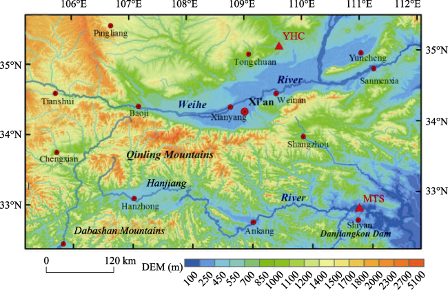
Figure 1 Site map showing the position of the Weihe River valley and the upper reaches of the Hanjiang River valley. The locations of the studied loess-paleosol sequences in the upper reaches of the Hanjiang and Weihe river valleys are marked with “▲”.
Samples were taken at depth intervals of 2 cm in the MTS profile, and 300 samples were collected in total. Samples were taken at depth intervals of 5 cm in the YHC profile, and 150 samples were collected for major element and magnetic susceptibility analysis. At the critical depth in the MTS profile (Figure 2), 10 samples were taken for the optically simulated luminescence (OSL) dating at the same time and tightly packed with lightproof materials. Magnetic susceptibility was measured using a Bartington MS2 magnetic susceptibility meter (0.47/4.7 kHz). Fe, Al, Si, K, and Na were analyzed using a PANalytical X-ray fluorescence spectrometer (XRF). Blue lighting-stimulated OSL dating was performed on a Risø-TL/OSL-DA15 Dating System using the fine-grain regeneration method in the TL/OSL Dating Laboratory of Shaanxi Normal University, China.
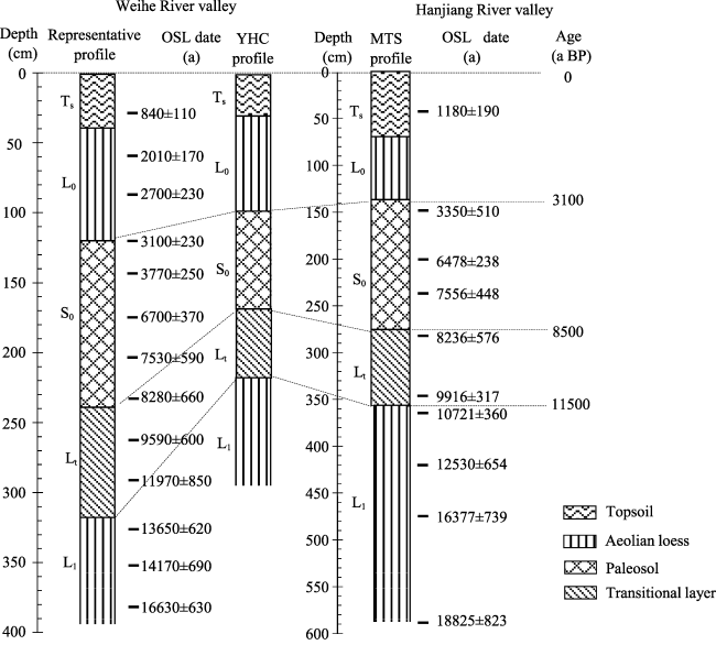
Figure 2 Pedo-stratigraphic correlations of the studied loess-paleosol sequences in the upper reaches of the Hanjiang and Weihe river valleys, China

4 Stratigraphy and chronology

Both the MTS and YHC profiles are well preserved. They were identified as accretionary profiles of aeolian origin based on their colors, texture and stratigraphic structure, and they share the same stratigraphic characteristics: Ts-L0-S0-Lt-L1 (Figure 2). Compared with the YHC profile, the topsoil layer (Ts) of the MTS profile has a darker color and more well-rounded spherical pellets; the aeolian loess layer (L0/L1) and transitional layer (Lt) of the MTS profile have similar textures and colors; and the paleosol layer (S0) of the MTS profile has a darker color and more red-brown ferri-argillans on structural surface (Table 1).
Table 1 Pedo-sedimentary descriptions of the loess-paleosol sequences at the MTS and YHC sites
Stratigraphy YHC profile in the Weihe valley MTS profile in the upper reaches of the Hanjiang valley
Topsoil (Ts) 0-30 cm, pale orange (10YR6/4),
silt, medium granular-blocky structure, friable, some bio-pores
0-70 cm, pale brown (7.5YR/5/4), silt, medium granular-blocky structure, friable, some bio-pores, moderately abundant well-rounded spherical pellets
Upper loess (L0) 30-100 cm, pale orange (10 YR 6/3), silt, blocky structure 70-140 cm, pale orange (10YR/6/4), silt, blocky-massive structure, weak pedogenesis
Paleosol (S0) 100-170 cm, pale brown (5YR 6/3), clay silt, blocky structure, relatively firm, some secondary calcite deposits 140-280 cm, dull brown (7.5YR/3/4), clayey silt, prismatic, angular blocky structure, firm, abundant bio-pores, abundant red-brown ferri-argillans on structural surfaces
Transitional loess (Lt) 170-220 cm, pale orange (10YR 7/3), blocky structure, silt, abundant secondary calcite deposits (pseudo-mycelia) 280-360 cm, pale yellow orange (10YR/7/4), silt, blocky structure, few red-brown ferri-argillans in the fissure plane
Malan loess (L1) 220-300 cm, pale orange (10YR 7/4), silt, constant massive structure, very friable, uniform structure 360-600 cm, pale yellow orange (10YR/7/3), silt, constant massive structure, very friable, few bio-pores, thickness greater than 3.0 m, covering a riverbed phase layer of coarse gravel
The field observations indicate that the Ts layer and the paleosol S0 layer of the MTS profile experienced stronger weathering intensity than those of the YHC profile, but this conclusion should be supported by more experimental data.
The chronological framework of the pedo-stratigraphy in the profiles was established using the OSL dating method and stratigraphic correlation method (Figure 2). Although the OSL age of the YHC loess-paleosol sequence was not experimentally determined, it was obtained indirectly via correlation with the representative pedo-stratigraphy in the Weihe River valley (Huang et al., 2000; Wang et al., 2012; Zhang et al., 2012). The OSL age of the pedo-stratigraphy at the MTS site in the upper reaches of the Hanjiang River valley was close to the calibrated age of the representative loess-paleosol sequence in the Weihe River valley. The pedo-stratigraphic boundary between the Malan loess (L1) deposited during the last glaciation and the lower Holocene transitional loess (Lt) in the MTS and YHC profiles was dated to be 11,500 a BP. The paleosols (S0) in the two profiles were dated to the mid-Holocene Climatic Optimum (8500-3100 a BP). In other words, the chronological frameworks of the loess-paleosol sequences in the Weihe and Hanjiang river valleys were essentially consistent.

5 Results and interpretations

5.1 Major element compositions

The average contents of major elements in the YHC and MTS profiles are listed in Table 2. The data show the following characteristics. (1) The main components of the loess-paleosol sequences are SiO2, Al2O3, and Fe2O3, together comprising 83.24% and 77.41% of the MTS and YHC profiles, respectively. The order of the major element concentrations in the two profiles is Si > Al > Fe > K > Mg > Na > Ca. The coefficient of variance (CV) values for Si, Al, Fe, K, Mg, and Na in the two profiles are all lower than 11%, which indicates that the major elements are consistent throughout both profiles. These data support the hypothesis that the loess in both the Hanjiang River valley and the Weihe River valley is aeolian in origin. (2) Comparing the concentrations of mobile elements (MgO, Na2O, and CaO) and immobile elements (Fe2O3, Al2O3 and K2O) between the MTS profile and YHC profile, the mobile element concentration is lower in the MTS profile than in the YHC profile. The immobile element concentration is higher in the MTS profile than in the YHC profile. This pattern implies that the soluble elements were leached more extensively (thereby enriching the insoluble element) with depth in the loess-paleosol sequence in the upper reaches of the Hanjiang River valley, which experienced relatively stronger weather intensity than the profile in the Weihe River valley.
Table 2 Comparison of the major element contents, magnetic susceptibility, CIA and CIW between the MTS profile in the upper reaches of the Hanjiang valley and the YHC profile in the Weihe valley, China
Profile Stratigraphy Sample SiO2 CaO Fe2O3 Al2O3 MgO K2O Na2O Χlf CIW CIA
Quantities ×10-8 m3/
kg
MTS
profile
TS 36 620.4 10.9 59.2 150.9 20.2 32.8 11.2 313.44 80.28 67.50
L0 35 630.3 11 54.1 143.9 20.6 31.1 13.6 192.5 77.26 65.10
S0 70 630.5 10.8 57.3 146.6 19.8 31.7 12.3 271.6 79.46 67.09
Lt 40 633.1 10.7 55.6 146.1 21.6 30.7 12 67.61 78.80 66.79
L1 58 640.8 11.5 52.6 140.7 21.4 29.9 14.2 54.11 74.01 64.36
CV 1.36 7.21 5.2 3.02 4.18 3.62 10.2
YHC profile TS 15 541.4 13.6 46.7 130.2 24.6 23 13.6 110.7 74.85 65.15
L0 40 551.2 13.5 48.2 131.5 25.4 23.7 13.5 115.8 74.64 65.28
S0 40 597.6 12.9 49.1 138 24.2 24.4 12.9 127.9 75.92 66.68
Lt 10 561 13.5 46.5 130.8 24.5 23 13.5 78.3 75.81 65.38
L1 20 591.2 13.9 44.7 129.2 24.6 22.7 13.9 51.2 73.59 64.69
CV 4.29 27.17 4.05 2.96 3.51 3.18 3.42
Compared with the average chemical composition of the upper continental crust (UCC) (Gallet, 1998), the major element distribution patterns are almost flat and close to those of the UCC, with the exception of Na and Ca in the two representative profiles (Figure 3). These patterns indicate that the loess of the Hanjiang River valley and the Weihe River valley is from multiple sources and is well mixed. The concentrations of Na and Ca deviate from the average concentration of the UCC, which might be attributable to the chemical weathering during the process of pedogenesis, as Na and Ca are prone to leaching in warm and humid climates and enrichments in cold and arid regions. Compared with data of Ca in the paleosol (S0)/Malan loess (L1) layers between the two study areas, the concentration of Ca in paleosol (S0)/Malan loess (L1) layers of the Hanjiang River valley is much higher. This is possibly attributable to a different paleoclimate; the Hanjiang River valley is warmer and more humid than the Weihe River valley. In addition, the leaching rate of Na in the Hanjiang River valley was similar to that of the Weihe River valley, indicating that Na might have been leached out in the source area and was little affected by the process of pedogenesis.
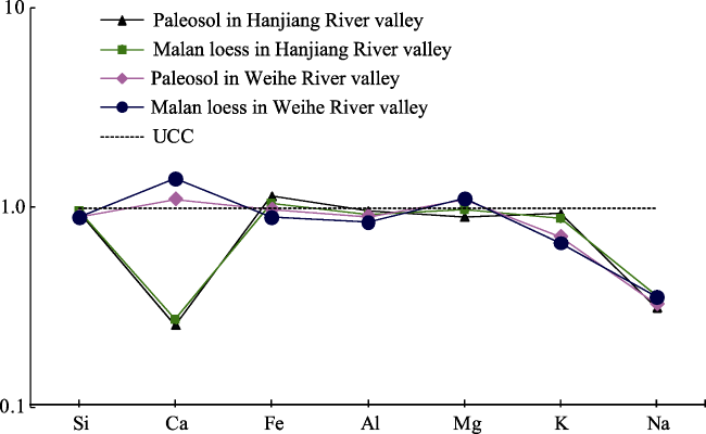
Figure 3 The UCC-normalized pattern of major elements of the loess-paleosol sequences in the Weihe River valley and upper reaches of the Hanjiang River valley

5.2 Chemical weathering intensity

5.2.1 Chemical indices (CIA and CIW)
The upper crust is dominated by plagioclase and K-feldspar-rich rocks and their weathering products, clay minerals (Nesbitt and Young, 1984, 1989). Plagioclase and K-feldspar account for 41% and 21% of the mineral composition of the crust, respectively (Wedepohl, 1969). Feldspar is the main mineral affected by chemical weathering in the upper crust. Alkali metal elements are leached out of feldspar in ionic form and participate in the formation of clay minerals. The molar fraction of Al2O3 (the main component in the weathering products) varies with the chemical weathering intensity. Thus, the chemical index of alteration (CIA) was proposed by Nesbitt and Young to evaluate the degree of chemical weathering (Table 2):
CIA=[Al2O3/(Al2O3+CaO*+K2O+Na2O)]×100 (1)
Several papers on the geochemistry of sedimentary rocks and paleosols have reported that K is typically more abundant than might be predicted based on the basement sources, which led Harnois (Harnois, 1988) to propose a new weathering index, the chemical index of weathering (CIW):
CIW= [Al2O3/ (Al2O3+CaO* +Na2O)] ×100 (2)
The two indices are calculated using molecular proportions, in which the CaO* represents the content of CaO in silicates, excluding the CaO in carbonates and phosphates. Generally, the ratio of CaO to Na2O in silicate rocks is 1:1. Therefore, McLennan suggested that if the concentration of CaO is higher than that of Na2O, one can assume mCaO*=mNa2O; otherwise, mCaO*=mCaO (McLennan, 1993). All values of mCaO* in this paper are calculated according to this method. According to the research of Li and Feng (Feng et al., 2003; Li et al., 2007), a CIA value between 50 and 65 indicates that the aeolian dust experienced a degree of weak weathering intensity under cold and dry climate conditions. If the CIA value is between 65 and 85, the aeolian dust experienced a moderate chemical weathering intensity under a warm and moist environment. If the CIA value is between 85 and 100, the loess experienced a strong weathering intensity under hot and humid climate conditions.
The CIA values of different layers in the MTS loess-paleosol sequence range from 64.36 to 67.50, and the values in the YHC profile are somewhat lower than those of the MTS profile, ranging from 64.69 to 66.68 (Table 1). Both the CIA values of the YHC and MTS profiles are significantly higher than that of the UCC (47.92) and approach the moderate chemical weathering intensity. Compared with the YHC profile, the CIW value of the MTS is slightly higher, and the mean values of CIW at YHC and MTS sites are 74.885 and 77.9, respectively. These values indicate that the loess-paleosol profile of the Hanjiang valley experienced stronger chemical weathering than that of the Weihe valley. In the two profiles, the different layers of the loess-paleosol sequence exhibit the following order in terms of chemical weathering intensity: Malan loess (L1) < transitional loess (Lt) < upper loess (L0) < paleosol (S0). Comparing the chemical weathering intensities of the same layer in the two profiles, the difference in the Malan loess was minimal, whereas the difference in the paleosol was the greatest. Therefore, the parent rocks of the two profiles were compositionally similar to the Malan loess (lowest CIA value), and the differences in temperature and humidity were most obvious during the period of paleosol formation.
5.2.2 A-CN-K diagram
Nesbitt and Young (1982) developed the A-CN-K (Al2O3-CaO*+Na2O-K2O) ternary diagram to predict the continental chemical weathering trend. This diagram can reflect the chemical weathering trend and changes in the main components and minerals during the chemical weathering process. Terrestrial shale is the typical chemical weathering product of the UCC. Thus, the direction from UCC to terrestrial shale on the diagram represents the typical trend of continental chemical weathering.
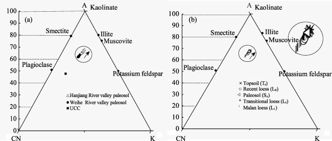
Figure 4 A-CN-K ternary diagrams of the loess-paleosol sequences (the arrows indicate the weathering trend)
(a) Comparison of the paleosol layers between the Hanjiang valley (MTS site) and the Weihe valley (YHC site); (b) The different layers of the MTS site in the upper reaches of the Hanjiang River valley. A=Al2O3; CN=CaO*+Na2O; K=K2O
Both the MTS and YHC loess sediments are plotted along the chemical weathering trend line of UCC to terrestrial shale (Figure 4a). This pattern demonstrates that both the sediments of the two regions are derived from rocks with an overall composition similar to the UCC. The weathering trend line of the loess sediments parallels the CN-A boundary, which means that plagioclase weathered first, thereby rapidly releasing Ca and Na, whereas potassium feldspar was relatively stable. In the MTS profile (Figure 4b), the leaching rate of Na and Ca increases in the order of Malan loess (L1) → recent loess (L0) → transitional loess (Lt) → paleosol (S0). Compared with the paleosol in the Weihe River valley, the data points from the Hanjiang River valley are plotted closer to the A-K boundary. Therefore, the silicates have experienced stronger weathering intensity, and plagioclase was weathered into smectite and illite via Ca and Na leaching, whereas K was not leached, and little kaolinite was produced.

5.3 Mobility of major elements

5.3.1 Mobility sequence of major elements
The major element absolute concentrations are somewhat variable due to differences in active element transport. However, their removal increases the proportion of stable elements during chemical weathering, which confuses the true characteristics of element migration. Thus, the variation ratio of an element compared to a stable element was selected to show the real features of element migration and enrichment. The formula is as follows:
=[(XsIs)∕(Xp/Ip)-1]×100%
where Xs and Is represent the concentrations of element X and stable element I in the paleosol, respectively; and Xp and Ip represent the concentrations of element X and stable element I in the parent rocks, respectively (Malan loess was used as a substitute for unweathered rock). When △<0, X is relatively leached compared to I. If △>0, element X is relatively enriched. The variation percentage of each element is calculated by using K as the stable element (Figure 5).
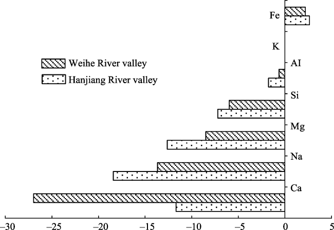
Figure 5 Comparison of the migration ratio of major elements in the paleosol layer between the upper reaches of the Hanjiang valley (MTS site) and the Weihe valley (YHC site) calculated relative to the stable element K
According to Figure 5, the major element migration characteristics of the paleosol layer in the Hanjiang River valley are very similar to those of the Weihe River. (1) The △ of most elements, such as Ca, Na, Mg, Si, and Al, is <0, which demonstrates that these elements were leached during the chemical weathering. In contrast, the △ value of Fe is slightly greater than 0, suggesting that Fe2O3 is relatively stable and inactive in the profile. Consequently, the relative concentration of Fe increased in the two profiles. (2) The activity and mobility sequence of the major elements in the Hanjiang River valley is as follows: Na>Mg>Ca>Si>Al>K>Fe. According to mobility, the major elements, listed in descending order, in the Weihe River valley exhibit the following order: Ca>Na>Mg>Si>Al>K>Fe. (3) Compared with the Weihe River valley, the △ values of Al, Si, Mg, and Na are obviously higher, indicating that the active elements in Hanjiang were leached to a greater degree during aeolian dust deposition and pedogenesis. The paleosol layer in the Hanjiang River valley has experienced stronger chemical weathering than the paleosol layer in the Weihe River valley.
5.3.2 Geochemical characteristics of the loess-paleosol sequences
We choose four representative geochemical indices (the migration ratios of Fe and Na calculated relative to the stable element K and the values of CIA and CIW) and magnetic susceptibility to discuss the differences and similarities of the geochemical characteristics of the loess-paleosol sequences at the MTS site and YHC site (Figure 6).
The immobile element Fe and the most mobile element Na were selected to explore their migration behaviors in the different layers.The most mobile element is Na, which is easily leached in the humid and warm environments. In terms of the mobility of Na, the different layers in the Weihe and Hanjiang river valleys exhibited the following descending order: paleosol (S0) > transitional loess (Lt) > recent loess (L0) > Malan loess (L1). The mobility ratio of Na is really higher in the paleosols, demonstrating that the environment was warm and humid during paleosol formation. Thus, a certain amount of Na was leached out as the aeolian dust interacted with biologic and pedogenic processes. In contrast, the mobility of Na is lower in the loess layer, which indicates that the environment was cold and dry during the period of dust accumulation and that the dust experienced weak chemical weathering. Compared with the YHC site, the mobility ratio of Na in the MTS site is significantly higher. The average migration ratios of Na in the MTS and YHC sites are -11.9% and -5.9%, respectively, indicating that the aeolian loess experienced stronger chemical weathering in the Hanjiang River valley. The variation curve of Fe with depth in the profile is contrary to the pattern of Na in the YHC and MTS profiles. Fe is stable; thus, when active elements are leached out of the system, the concentration of Fe relatively increases; otherwise, the migration ratio of Fe would decrease. Therefore, Fe is relatively enriched in the paleosol layer, and the mobility is relatively low in the loess layers (including the Malan loess, recent loess, and transitional loess). These patterns indicate that the paleosol layer developed in a warm and humid environment and that the loess formed in a dry and cold environment. According to the enrichment ratio of Fe, the layers in the Weihe and Hanjiang river valleys can be listed in the following descending order: paleosol (S0) > transitional loess (Lt) / recent loess (L0) > Malan loess (L1). The variations in the migration ratio of Fe in the two profiles agrees with the morphological characteristics and structures, such as the layer of paleosol composed of dull brown clayey silt with abundant red-brown ferri-argillans on the structural surfaces and the layers of loess composed of pale yellow-orange silt with porous structures and few ferri-argillans on the structural surfaces. The CIA and CIW values are widely used to interpret the chemical weathering intensity of feldspar in modern and ancient sediments (Nesbitt and Young, 1982). The variation curves of the CIA and CIW values synchronously change with the element migration and magnetic susceptibility variations. These patterns show that the paleosols (S0) of the YHC and MTS sites experienced moderate chemical weathering intensity and a degree of chemical weathering that is significantly higher than that of the topsoil and loess layers (Lt, L0, and L1). Comparing the CIW value and magnetic susceptibility values of the MTS and YHC sites, the values of the MTS site are significantly higher than those of the YHC site. Therefore, the loess-paleosol sequence in the upper reaches of the Hanjiang River valley experienced stronger chemical weathering than that in the Weihe River valley.
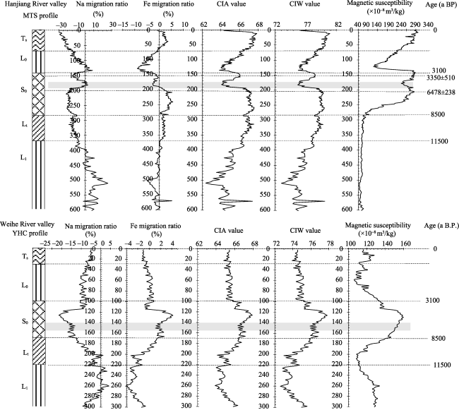
Figure 6 Comparison of the variations in CIA, CIW, magnetic susceptibility and migration ratios of elements Fe and Na throughout the loess-paleosol sequences in the Hanjiang valley (MTS site) and Weihe valley (YHC site)
Notably, at the depth of 170-190 cm in the paleosol layer (S0) at the MTS site, the four geochemical indices of this section exhibit obvious fluctuations that indicate that the pedogenic environment of this section was cold and dry. Compared with the MTS site, the chemical index fluctuations in response to climate are not particularly evident at the YHC site. This may be due to micro-topographic and micro-climatic factors. However, at the depth of 140-150 cm, the data still effectively indicate that this section experienced weak chemical weathering. According to the OSL ages of the MTS profile and the interpolated ages of the YHC profile (Figure 6), the sections with weak pedogenesis were dated to 6000-5000 a BP. This period has been shown to feature a period of climate deterioration that resulted in a section of weak pedogenesis in the midst of the paleosols (S0) in the two profiles. This period of climate deterioration was also recorded by various climatic proxies, including ice cores, pollen, peat and marine sediments. Bond observed an ice-rafted debris (IRD) event at 5900 a BP in a North Atlantic deep-sea core (Bond G et al., 1997). O’Brien found that the concentration of sea salt and dust increased during the period of 6100-5000 a BP (O’Brien, 1993). Studying worldwide Holocene glacier fluctuations, Denton proposed a third major interval of glacier advances at approximately 5800-4900 a BP (Denton and Karlén, 1973). Many lines of evidence, including climate proxies based on ice cores, peat, pollen, and marine sediment, suggest that drought and flood events occurred during 6000-5000 a B P in Jilin, Qinghai, Sichuan, Guangdong, and Qinghai provinces and in the South China Sea (Wang et al., 1999; Hong et al., 2005; Liu et al., 2000; Zhou et al., 2001).

5.4 The controlling factor of chemical weathering

The chemical composition and CIA value of the Malan loess in the Weihe River valley and Hanjiang River valley were very similar, suggesting that the parent rocks of the two regions were very similar. However, the weathering intensities of their paleosols exhibit obvious differences. Compared with the paleosol in the Weihe River valley, the paleosol in the upper reaches of the Hanjiang valley experienced stronger pedogenesis, based on the geochemical indices (CIA and CIW), A-CN-K diagrams, and major element mobility data. The factors that usually influence chemical weathering include topography, drainage conditions, soil erosion, environmental conditions, etc. The selection process of the studied profiles has avoided some influencing factors, such as topography, drainage conditions, and soil erosion; therefore, the factor controlling the chemical weathering intensity differences is the environment. According to the doctrine “the present is the key to the past”, the precipitation and temperature values of the upper reaches of the Hanjiang River valley are clearly higher than those of the Weihe River valley and may be the two important factors influencing the pedogenic intensity.
The mobility characteristics of Fe and Na with depth in the YHC and MTS profiles indicate that the period of paleosol (S0) formation (8500-3100 a BP) was humid and warm, whereas the periods of loess deposition (3100-1500 a BP, 11,500-8500 a BP, and >11,500 a BP) were relatively cold and dry.

6 Conclusions

A comparative study of the chemical weathering intensity and element transport features of loess-paleosol sequences in the upper reaches of the Hanjiang River valley and the Weihe River valley was conducted. This research has reached the following conclusions.
(1) The main components of the loess-paleosol sequences in the Hanjiang and Weihe river valleys are SiO2, Al2O3, and Fe2O3, and the major element compositions are consistent throughout the profiles. Furthermore, these compositions are quite similar to the composition of the upper continental crust, indicating that the loess of the two regions came from multiple sources and was well mixed. Thus, these sediments are interpreted to be aeolian loess.
(2) The loess-paleosol sequences in the Hanjiang and Weihe river valleys both experienced moderate chemical weathering. The chemical index values (CIA and CIW), the leaching rates of Ca and Na, and the mobility of the major elements were obviously higher in the paleosol layer. Thus, the chemical weathering intensity of the paleosol is stronger than the loess layers. The mobility of the elements in the paleosol layer was as follows: Fe<K<Al<Si<Mg<Na.
(3) Compared with the morphological and color characteristics, magnetic susceptibility, chemical index values (CIA and CIW), and major element mobilities of the Weihe River valley profile, the profile in the upper reaches of the Hanjiang River valley experienced stronger chemical weathering. The precipitation and temperature differences between the Hanjiang River valley and the Weihe River valley are the primary controlling factors that explain the differences in pedogenic intensity between the two regions.
(4) Both the YHC and MTS profiles record a period of climate deterioration at 6000-5000 a BP based on the variations in Fe and Na mobilities, CIA and CIW values, and magnetic susceptibility at the depth ranges of 140-150 cm and 170-190 cm, respectively.

The authors have declared that no competing interests exist.

[1]
Amiotte Suchet P, Probst J L, 1993. Modelling of atmospheric CO2 consumption by chemical weathering of rocks: Application to the Garonne, Congo and Amazon basins.Chemical Geology, 107(3): 205-210.Modelling of atmospheric CO, consumption by chemical weathering of rocks: Application to the Garonne, Congo and Amazon basins

DOI

[2]
Bond G, Showers W, Cheseby M, 1997. A pervasive millennial-scale cycle in north Atlantic Holocene and glacial climates.Science, 278: 1257-1266.

[3]
Chen J, An Z, Head J, 1999.Variation of Rb/Sr ratios in the loess-paleosol sequences of central China during the last 130,000 years and their implications for monsoon paleoclimatology.Quaternary Research, 51(3): 215-219.Rb, Sr, and magnetic susceptibility have been measured in the last interglacial090009glacial loess profiles at Luochuan and Huanxian, central China. A high degree of similarity between the parameters in both profiles suggests that variations of Rb/Sr ratios in the sequence can be regarded as an indicator of East Asian summer monsoon strength. Matching the Rb/Sr record with the SPECMAP 020718O curve suggests that the Rb/Sr ratio responds sensitively to changes of the East Asian monsoon induced by global ice-volume variation.

DOI

[4]
Chen Y, Li X, Han Z, Yang S,et al., 2008. Chemical weathering intensity and element migration features of the Xiashu loess profile in Zhenjiang, Jiangsu Province.Journal of Geographical Sciences, 18(3): 341-352.The chemical weathering intensity and element migration features of the Xiashu loess profile in Zhenjiang are studied in this paper.(1)The Xiashu loess profile underwent moderate chemical weathering.It seems that the precipitation is a more important factor than the temperature in controlling the process of the chemical weathering.(2)The major elements such as Si,K,Na,Ca,Mg,Mn and P were migrated and leached,while the elements Fe and Ti were slightly enriched.The migration features of the major elements reveal that the Xiashu loess finished the primary process of chemical weathering characterized by leaching of Ca and Na,and almost reached the secondary process characterized by leaching of K.Except the elements Sr and Ga,other trace elements such as Th,Ba,Cu,Zn,Co,Ni,Cr and V were enriched.It might be caused by both the biogeochemical process and the adsorption of trace elements by clay mineral and organic materials.(3)The difference of element migration down the Xiashu loess profile reveals that the climate was warm and wet at the early-middle stage of the middle Pleistocene.At the end of the middle Pleistocene,it became dry and cool.At the early stage of the Late Pleistocene,the paleoclimate became warm and wet again.As a whole,the paleoclimate generally became drier and cooler in this region from the beginning of the middle Pleistocene.

DOI

[5]
Dalai T K, Krishnaswami S, Sarin M M, 2002. Major ion chemistry in the headwaters of the Yamuna river system: Chemical weathering, its temperature dependence and CO2 consumption in the Himalaya.Geochimica et Cosmochimica Acta, 66(19): 3397-3416.This study brings to light the sources contributing to major ions, enhanced chemical weathering rates in the Yamuna River Basin and interdependence of silicate weathering on physical erosion and temperature.

DOI

[6]
Denton G H, Karlén W, 1973. Holocene climatic variations: Their pattern and possible causes.Quaternary Research, 3: 155-205.

[7]
Feng L J, Chu X L, Zhang Q R,et al., 2003. CIA and its applications in Neoproterozoic clastic rocks.Earth Science Frontier, 10(4): 539-544. (in Chinese)

[8]
Gallet S, Jahn B, Van Vliet Lanoë B,et al., 1998. Loess geochemistry and its implications for particle origin and composition of the upper continental crust.Earth and Planetary Science Letters, 156(3): 157-172.

[9]
Guo Z, Biscaye P, Wei L,et al., 2000.Summer monsoon variations over the last 1.2 Ma from the weathering of loess-soil sequences in China.Geophysical Research Letters, 27(12): 1751-1754.The loess-soil sequence in northern China contains a near continuous record of Quaternary paleoclimate. Magnetic susceptibility and grain size have so far been the only proxies available to address the long-term changes of the East-Asian paleomonsoon extending back to more than one million years. In this study, the ratio of CBD (citrate-bicarbonate-dithionite)-extractable free FeO(FeD), a measure of iron liberated by chemical weathering, versus the total FeOavailable (FeT) was measured on samples at 10 cm intervals taken from two loess sections deposited over the last 1.2 Ma. Variations of this index are highly consistent with other pedological indicators, but in addition provide a quantitative measurement of the degree of pedogenesis in the Loess Plateau. Since chemical weathering in the region mainly depends upon summer precipitation and temperature, weathering intensity primarily reflects changes in the East-Asian summer monsoon. The new proxy has been used to document a series of summer monsoon changes of global significance, which are not necessarily recorded by magnetic susceptibility.

DOI

[10]
Harnois L, 1988. The CIW index: A new chemical index of weathering.Sedimentary Geology, 55(3/4): 319-322.The value of this index increases as the degree of weathering increases, and the difference between CIW index values of the silicate parent rock and soil or sediment reflects the amount of weathering experienced by the weathered material.

DOI

[11]
Hong Y T, Hong B, Lin Q H,et al., 2005. Inverse phase oscillations between the East Asian and Indian Ocean summer monsoons during the last 12000 years and paleo-EI Nino.Earth and Planetary Sciences Letters, 231(3/4): 337-34654.The inverse phase variations between the East Asian and Indian Ocean summer monsoons on the interannual timescale result from the El Ni09o-Southern Oscillation activity in the tropical Pacific, which potentially provides a new way for studying paleo-ENSO. Here we reconstruct a 1202000-yr proxy record for the East Asian summer monsoon from δ 13 C time series of the plant cellulose of the Hani peat bog in the northeastern China. The comparison of it with the peat proxy record of the Indian Ocean summer monsoon suggests that the El Ni09o conditions are coincident with strong East Asian summer monsoons, weak Indian summer monsoons, and drift ice events in the North Atlantic at both orbital and millennial time scales. The orbital-scale inverse phase relationships between the monsoons indicate the occurrence of a long-term ENSO-like pattern, confirming the sensitivity of the monsoon systems associated with ENSO to insolation forcing. The nine inverse phase variations on the millennial time scales may suggest the nine El Ni09o-like patterns superimposing the long-term ENSO-like pattern. The inverse phase variations between the monsoons also show close correspondence to the drift ice events at high northern latitudes. In every case when the abrupt ice-rafted debris events occurred in the North Atlantic, the inverse phase relationship established, and the El Ni09o-like pattern occurred in the tropical Pacific correspondingly. The discussions on the influence of ocean thermohaline circulation on these global linkages have been made.

DOI

[12]
Huang C C, Zhou J, Pang J L,et al., 2000. A regional aridity phase and its possible cultural impact during the Holocene Megathermal in the Guanzhong Basin, China. Holocene, 10: 135-142.Evidence of climatic variations and the impact of past farming was identified in a Holocene loess profile near Xi'an in the Guanzhong Basin, China. Detailed studies of the profile indicate that crop cultivation began at 7000 yr BP in the Neolithic and carried on to present in the area. Disturbance of the profile by cultivation has not masked evidence of changes in aeolian dust deposition and bio-pedogenic processes caused by climatic variations. Increased dust deposition indicates that a remarkable aridity phase occurred from 6000 to 5000 yr BP during the Holocene Megathermal (8500-3000 yr BP). The aridity and intensified aeolian dust deposition interrupted the formation of the brown soil developing under a warm-humid subtropical climate during the Megathermal. The palaeosol S

DOI

[13]
Land M, Ingri J, Öhlander B, 1999. Past and present weathering rates in northern Sweden.Applied Geochemistry, 14(6): 761-774.Past and present chemical weathering rates in granitic till have been estimated. The Kalix River watershed in northern Sweden was used as a study area in which 17 evenly distributed soil profiles were investigated. The two estimations are based on elemental depletion trends in soil profiles and input/output budgets for the elements in the watershed, respectively. In the calculations of the past weathering rate it was assumed that zircon is resistant, and thus Zr was considered to be immobile during weathering. The long-term average chemical erosion rate since the area was deglaciated 8700 a ago, expressed as the sum of major element oxides (SiO 2 , Al 2 O 3 , CaO, Fe 2 O 3 , K 2 O, MgO, MnO, Na 2 O), was estimated to be 5.8 g·m 612 ·a 611 . In terms of base cation (Ca 2+ , Mg 2+ , Na + , K + ) depletion this corresponds to 0.36 keq·ha 612 ·a 611 . All elements analysed have been depleted from the E-horizon, and the most affected elements are P with an average mass loss of 86% (as P 2 O 5 ), La 81%, Co 78%, Cu 77% and Ni 76%. The present-day weathering rate was calculated as the difference between outputs and inputs in the Kalix River watershed. The input was considered as the contribution from precipitation, while the output was calculated as the sum of (1) the river-transported dissolved fraction, (2) the river-transported suspended non-detrital fraction (chemically precipitated Fe- and Mn-oxy-hydroxides and matter sorbed on these particles), and (3) the biotic nutrient net uptake. River-transported outputs were measured for an annual cycle starting in September 1991 and ending in August 1992. The present-day chemical erosion rate of the till was estimated to be 6.3 g·m 612 ·a 611 (sum of major element oxides), or a base cation flux of 1.42 keq·ha 612 ·a 611 . Part of this present-day rate is related to carbonate weathering in the Caledonian mountain range which makes it difficult to compare the present weathering rate with the historical weathering rate. After correction for carbonate weathering the resulting present-day weathering rate of granitic till in terms of base cation flux was estimated to be 0.65–0.75 keq·ha 612 ·a 611 . This result indicates that the present cation flux has increased by a factor of 1.8–2.1 compared to the long-term average. However, given the uncertainties introduced by the carbonates in the Caledonian mountain range it is not possible to prove any significant difference between the mean post-glacial and the present-day weathering rate with the methods used in this study.

DOI

[14]
Li X S, Han Z Y, Yang S Y, 2007. Chemical weathering intensity and element migration features of the Xiashu loess profile in Zhenjiang.Acta Geographica Sinica, 62(11): 1174-1184. (in Chinese)The chemical weathering intensity and element migration features of the Xiashu loess profile in Zhenjiang are studied in this paper.Based on the comparison with other aeolian-dust deposits,i.e.Quaternary loess-palesol and late-tertiary red-clay profiles in the Loess Plateau,and aeolian dust red earth in Xuancheng of Anhui province,we draw the following conclusions:(1)The Xiashu loess profile underwent moderate chemical weathering,which was stronger than that of the loess and palesol in Luochuan,much weaker than that of the aeolian dust red earth in Xuancheng,and similar to that of late-tertiary red-clay in Xifeng.The chemical weathering differences among the studied aeolian-dust deposits were mainly induced by the distinction of the climate condition,which imposed important influence on the geochemical environment through the mean annual temperature and annual precipitation.It seems that the annual precipitation has more important influence on the chemical weathering process.(2)The major elements such as Si,K,Na,Ca,Mg,Mn and P were migrated and leached,while the elements Fe and Ti were slightly enriched during the chemical weathering process.According to the migration ability,the major elements are ranked in the following order:P Na Ca Mg K Fe2+ Si Mn Al Ti Fe3+.The migration features of the major elements reveal that the Xiashu loess finished the primary process of chemical weathering characterized by leaching of Ca and Na,and almost reached the secondary process characterized by leaching of K.Except the elements Sr and Ga,other trace elements such as Th,Ba,Cu,Zn,Co,Ni,Cr and V were enriched during the chemical weathering process.And this enrichment might be caused by both the biogeochemical process and the adsorption of trace elements by clay mineral and organic materials during the chemical weathering.(3)The difference of element migration down the Xiashu loess profile reveals that the climate was warm and wet at the early-middle stage of the Middle Pleistocene(before 0.24 Ma),however,bearing the feature of an alternate dry and wet fluctuation.At the end of the Middle Pleistocene,it became dry and cool,which resulted in the weakest weathering and element migration.At the early stage of the Late Pleistocene,the paleoclimate became warm and wet again,which led to rather strong pedogenesis and the formation of the paleosol S1 in the Xiashu loess profile.As a whole,the paleoclimate generally became drier and cooler in this region from the beginning of the Middle Pleistocene.

DOI

[15]
Liu X, Heller F, Xu T, 1990. Frequency-dependent susceptibility of loess and quaternary paleoclimate.Quaternary Sciences, 10(1): 42-50. (in Chinese)A continuous loess stratigraphy provides a basis for study of Quaternary climate. There is a correlation between the loess profiles in Xifeng and Baicaoyuan, Gansu Province, and Baoji and Luochuan, Shaanxi Province, some common features of the loess-pedostratigraphic development on the Loess Plateau are verified. A comparison between the curves of deep-sea oxygen isotope and magnetic susceptibility of loess within stage 1鈥5 suggests the continuity of the loess stratigraphy although pedostratigraphic research gives some small interfaces in it. Evident difference in thickness or depositional rate of loess appeared mainly since about 1.7 Ma B. P. The intensity of paleoclimatic information from the loess strata is inversely proportional to the resolution of paleoclimate over the plateau. The intensity increases gradually from NW to SE Loess Plateau, and the resolution vice versa. The paleoclimatic information in the loess strata is composed of two parts: global and regional signals. The gradual increase of signal intensity from NW to SE Loess Plateau is a reflection of the regional signal, and the same cycles of loess (dry-cold period) and paleosol (wet-warm period) in different profiles on the plateau represent the global change of paleoclimate. The variation in frequency-dependent susceptibility (x_(fd)) of loess stratum, i.e. its wave peak and valley is associated regularly with the appearance of paleosol and loess layers in the profiles. It indicates formation of ultrafine-grained (0.03渭m) ferromagnetic minerals in the pedogenic processes, which may be the most important factor for higher susceptibility of paleosol than loess. The content of the ultrafine-grained magnetic minerals reflects the warm and humid degree of the paleoclimate. The frequency-dependent susceptibility has a clear implication for paleoclimate. It is sensitive for the slight variation of paleoclimate, and provides an important information on the paleoclimatic (gradual or sudden) change.

DOI

[16]
Liu X, Xu T, Liu T, 1988. The Chinese loess in Xifeng, II. A study of anisotropy of magnetic susceptibility of loess from Xifeng.Geophysical Journal International, 92(2): 349-353.Measurements of specimens from the loess profile of Xifeng, Gansu province, China, all show original magnetic fabric for sediments, i.e. nearly horizontal foliation and the commonly oblate magnitude ellipsoid. The degree of anisotropy always shows a strong correlation with the foliation rather than with the lineation Specimens from wind-blown loess, redeposited water-lain loess and red clay show their own distribution areas respectively in a diagram of versus . Magnetic fabric provides evidence for the suggestion that the red clay, like the overlying wind-blown loess, is aeolian in origin, the data points from the red clay all falling within the distribution area of the wind-blown loess data points. The magnetic fabric measured from present-day palaeosols may still represent the features of the parent loess although the orientation of fabric has been slightly weakened through pedogenesis, as shown in the present study.

DOI

[17]
McLennan S M, 1993. Weathering and global denudation.Journal of Geology 101(2): 295-303.

[18]
Meybeck M, 1987. Global chemical weathering of surficial rocks estimated from river dissolved loads.American Journal of Science, 287(5): 401-428.Abstract This article starts from the representative water analyses for major rock types commonly found on the continents. A theoretical world average is then set up on the basis of global outcrop proportions and compared to the observed composition. After discussion, this theoretical average is apportioned into the individual contributions from various minerals and rocks. As the water analyses are mostly derived from a previous study of unpolluted monolithologic French watersheds, this approach is called the Temperature Stream Model.

DOI

[19]
Nesbitt H W, Young G M, 1982. Early Proterozoic climates and plate motions inferred from major element chemistry of lutites.Nature, 299(5885): 715-717.The early Proterozoic Huronian Supergroup of the north shore of Lake Huron (Fig. 1) is a thick (up to 12,000 m) succession of sedimentary and volcanic rocks deposited between about 2,500 and 2,100 Myr ago 1 . Here we present a palaeoclimatic interpretation of the Huronian based on approximately 200 major elements analyses of lutites. Most of these are new analyses from the Gowganda and Serpent Formations (Fig. 2). The remainder are from published sources cited in Fig. 4. The composition of lutites from the Huronian Supergroup records an early period of intense, probably tropical, weathering followed by climatic deterioration that culminated in widespread deposition of glaciogenic sediments of the Gowganda Formation. Climatic amelioration followed during deposition of the succeeding Huronian formations. The Huronian succession can be interpreted using a uniformitarian approach in that present day seafloor spreading rates and latitude-related climatic variations are compatible with available geochronological and palaeomagnetic data.

DOI

[20]
Nesbitt H W, Young G M, 1984. Prediction of some weathering trends of plutonic and volcanic rocks based on thermodynamic and kinetic considerations.Geochimica et Cosmochimica Acta, 48(7): 1523-1534.Experimentally determined release rate constants are not available for a wide range of volcanic glass compositions, but the limited data indicate that compositional trends are predictable in weathering profiles developed on volcanic rocks. The kinetic data available for rhyolitic glasses accurately predict the initial weathering trends observed in a recent rhyolite weathering profile.

DOI

[21]
Nesbitt H W, Young G M, 1989. Formation and diagenesis of weathering profiles.The Journal of Geology, 97: 129-147.Weathering reactions mainly involve the transformation of feldspars, phyllosilicates, amphiboles, pyroxenes, and volcanic glass to the secondary mineral groups, kandites, illites, smectites, vermiculites, and/or chlorites. Although mineralogical changes are complex, bulk compositional changes to weathering profiles, resulting from chemical weathering, are simple and predictable from kinetic, thermodynamic, and mass balance considerations. Predicted bulk compositional changes are corroborated by studies of Recent weathering profiles developed on a variety of plutonic and volcanic rocks under different climatic regimes. Unlike the mineralogical compositions of profiles, the bulk compositional trends are not noticeably modified by climate; consequently, the simple, predictable bulk compositional trends observed in recent profiles provide a "norm" to which ancient weathering profiles can be compared. Early diagenetic reactions may occur prior to burial of the profile by reaction of groundwaters with secondary weathering products. These often result in abnormally high accumulations of Si, $CO_{2}$, Ca, and Mg to form clay minerals (smectites) and carbonates. The accumulations may be used as indicators of (paleo-)water tables. Late diagenetic reactions occur during and following burial through reaction of basin waters, trapped seawater, or brines with minerals of profiles. Metasomatism is common and includes production of illites, smectites, and chlorites at the expense of kaolinite and reconstitution of partially degraded feldspars to form potash feldspar and albite. Reaction with seawater (high Na/K and Mg/K) results in Na- and Mg-metasomatism, yielding albite and chlorite at the expense of partially degraded feldspars and clay minerals. In contrast, K-metasomatism of buried weathering profiles is favored around the periphery of subsiding continental sedimentary basins where dilute continental ground waters display low Na/K values. NaCl-rich brines and high temperatures in the deep central parts of basins favor the formation of albite at the expense of K-feldspar.

DOI

[22]
O’Brien E M, 1993. Climatic gradients in woody plant species richness-towards an explanation based on an analysis of southern Africa’s woody lora.Journal of Biogeography, 20(2): 181-198.

[23]
Oldfield F, 1999. The past global changes (PAGES) project: A personal perspective.Quaternary Science Reviews, 18(3): 317-320.ABSTRACT The present note seeks to provide a personal overview of the questions that dominate the research agenda of the PAGES project. These questions will be to the fore as PAGES research leaders develop a synthesis of the project and look ahead to the next stages in its development. An outline is presented of plans for considering, within the PAGES framework, the interplay of human activities and climate variability in the recent past.

DOI

[24]
Pang J L, Huang C C, 2006. Mid-Holocene soil formation and the impact of dust input in the middle reaches of the Yellow River, northern China.Soil Science, 171(7): 552-563.ABSTRACT Loess-paleosol sequences of the Chinese Loess Plateau provide important records of the late Pleistocene through Holocene climate change. The mid-Holocene paleosol S0 in the sequence has had limited study. During the Holocene Megathermal between 8500 and 3100 years B.P., there was a warm-wet climate in both the middle reaches of the Yellow River and the middle-lower reaches of the Yangtze River in China. Luvisols (Cinnamon soils) developed in the loess region in the middle reaches of the Yellow River, whereas Ferric-Luvisols (Yellow Brown Earth) formed in the middle-lower reaches of the Yangtze River. Our stratigraphic, micromorphological, and geochemical studies show that the mid-Holocene Luvisols in the middle reaches of the Yellow River developed on the contemporarily accumulated dust. The Ferric-Luvisol in the middle-lower reaches of the Yangtze River formed on the Xiashu Loess of the last glaciation. The difference in pedogenesis between the two regions during the mid-Holocene was caused by continuous eolian dust input into the soil body in the middle reaches of the Yellow River. The addition of the eolian dust caused the soil profile to extend both downward and upward simultaneously. Thus, the degree of pedogenesis was retarded between 8500 and 3100 years B.P. in the middle reaches of the Yellow River.

DOI

[25]
Qiao Y, Zhao Z, Wang Y,et al., 2009.Variations of geochemical compositions and the paleoclimatic significance of a loess-soil sequence from Garzê County of western Sichuan Province, China.Chinese Science Bulletin, 54(24): 4697-4703.The West Sichuan Plateau is located in the southeast margin of the Tibetan Plateau, where the climate is mainly influenced by the Indian southwest summer monsoon and the Tibetan Plateau monsoon. In this study, detailed geochemical analysis has been carried out on Ganzisi loess-paleosol sequence in Ganz锚 County of western Sichuan Province. The results indicate that Ganz锚 loess and paleosol have experienced the incipient stage of chemical weathering in dust source regions, characterized by the decomposition of plagioclase which caused the depletion of mobile elements Na and Ca. The post-depositional chemical weathering is characterized by carbonate dissolution and oxidation of Fe2+. The variations of some geochemical indexes (such as CIA values, Na/K and Fe2+/ Fe3+ ratios) in Ganzisi loess-paleosol sequence indicate a gradually decreased chemical weathering intensity in the dust source regions and deposition areas since 1.15 Ma BP consistent with the general increase of global ice volume, reflecting that the arid trend since 1.15 Ma BP in the southeast Tibetan Plateau is a regional response to the global climate change. The geochemical indexes in this section also reveal an obvious drying step occurred at about 250 ka BP in this region. We interpret this drying step as a result of decreased influence of the Indian southwest summer monsoon. This decrease in monsoon moisture is probably attributable to the uplift of the southeast margin of the Tibetan Plateau at about 250 ka BP.

DOI PMID

[26]
Singh A K, Mondal G C, Kumar S,et al., 2008. Major ion chemistry, weathering processes and water quality assessment in upper catchment of Damodar River basin, India.Environmental Geology, 54(4): 745-758.The chemical characteristics of surface, groundwater and mine water of the upper catchment of the Damodar River basin were studied to evaluate the major ion chemistry, geochemical processes controlling water composition and suitability of water for domestic, industrial and irrigation uses. Water samples from ponds, lakes, rivers, reservoirs and groundwater were collected and analysed for pH, EC, TDS, F, Cl, HCO 3 , SO 4 , NO 3, Ca, Mg, Na and K. In general, Ca, Na, Mg, HCO 3 and Cl dominate, except in samples from mining areas which have higher concentration of SO 4 . Water chemistry of the area reflects continental weathering, aided by mining and other anthropogenic impacts. Limiting groundwater use for domestic purposes are contents of TDS, F, Cl, SO 4 , NO 3 and TH that exceed the desirable limits in water collected from mining and urban areas. The calculated values of SAR, RSC and %Na indicate good to permissible use of water for irrigation. High salinity, %Na, Mg-hazard and RSC values at some sites limit use for agricultural purposes.

DOI

[27]
Stallard R F, Edmond J M, 1981.Geochemistry of the Amazon: 1. Precipitation chemistry and the marine contribution to the dissolved load at the time of peak discharge.Journal of Geophysical Research, 86(C10): 9844-9858.Analyses of precipitation and surface water are used to estimate the fluxes of marine cyclic salts through that part of the Amazon River system draining past Obidos (80% of the basin) at the time of peak discharge in June. Amazon precipitation chemistry can be devided into two principal components: marine and terrestrial. The marine component (determined from analyses of marine rain) consists of Na, K, Mg, Ca, and Cl in approximately sea-salt proportions, with S doubly enriched. The excess sulfur is probably derived from gas phase inputs. The terrestrial component makes an important contribution of K, Ca, S, and N, much of which can be related to biological emissions. The emission of reduced sulfur in the marine and terrestrial environment and nitrogen in the terrestrial environment is responsible for a natural 090004acid rain090005 in the Amazon region with a pH from 4.7 to 5.7. This is about one tenth the acidity of polluted urban rain. The chloride content of lowland rivers, which drain regions lacking significant geologic sources of chloride, shows a systematic decrease in chloride with increasing distance from the ocean. This trend is used to define the cyclic salt background for Amazonian surface waters. Cyclic salts, in general, make only a minor contribution, relative to terrestrial inputs, to the chemistry of Amazon Basin rivers, even those draining intensely weathered terrains. An estimated 17.6%-Cl, 6.9%-Na, 1.3%-Mg, 3.6%-S, 0.4%-K, and 0.1%-Ca of the dissolved load at Obidos during peak discharge is cyclic.

DOI

[28]
Viers J, Dupré B, Braun J,et al., 2000. Major and trace element abundances, and strontium isotopes in the Nyong basin rivers (Cameroon): Constraints on chemical weathering processes and elements transport mechanisms in humid tropical environments.Chemical Geology, 169(1): 211-241.

[29]
Wang H S, Huang C C, Zhou Y L,et al., 2012. OSL dating of Holocene loess-paleosol profiles in the middle reaches of Weihe River and paleoflood events.Acta Geologica Sinica, 86(6): 994-1004.Through extensive field investigation,paleoflood stagnant zones were found to occur in layers of the loess-paleosol profiles in the middle reaches of Weihe River.Authors carried out chronological and sedimentological study on the samples collected from the stagnant zones.Analyses of grain-size distribution and magnetic susceptibility for the samples collected from the Holocene strata suggest that the sediments hosted in the profiles are the paleoflood stagnant material and have recorded climatic and hydrological information of paleofloods during that period.Nine Optically Stimulated Luminescence(OSL) ages were obtained using the post IR SAR dating method,indicating that flooding occurred frequently during 3.2~2.8ka in middle reach of Weihe River.This study then reconstructed the chronology framework of the palaeoflood events in the middle reaches of Weihe River.The results reveal that palaeoflood occurred very frequently at the turning period from the middle Holocene to the late Holocene,during which the climate in the Weihe reaches turned to be dry.The leading reasons for extraordinary palaeofloods were unstable atmosphere system,dramatic changing climate,and variable precipitation.

DOI

[30]
Wang L, Sarnthein M, Erlenkeuser H,et al., 1999. Holocene variations in Asian monsoon moisture: A bidecadal sediment record from the South China Sea.Geophysical Research Letters, 26(18): 2889-2892.The East Asian monsoon system involves extensive transport of sensible/latent heat between land and sea and from low to high latitudes. Our high resolution, bidecadal marine records present a first detailed history of monsoon climate change over the Holocene. The high-amplitude perturbation in monsoon moisture centered at 8,150 years ago and the monsoon maximum in the Early Holocene show interhemispheric teleconnections to both a cool episode in Greenland and to the Indian monsoon monitored in the Arabian Sea. Periodicities of 84, 102 and, especially, near 775 years in monsoon variation suggest a climatic forcing both by long-term oscillations in thermohaline circulation and (possibly) solar activity cycles. [References: 19] 19

DOI

[31]
Wedepohl K H, 1969. Handbook of Geochemistry. Berlin: Springer Verlag.

[32]
Sun X, Du N, Weng C,et al., 1994. Paleovegetation and paleoenvironment of Manasi Lake, Xinjiang, N.W. China during the last 14000years.Quaternary Sciences, 14(3): 239-248.Abstract:A vegetational and environmental history of Manasi basin during the last 14 000yrs has been outlined on the basis of palynological data. Very low pollen influx andlow A/C ratio (Pollen percent ratio of Artemisia to Chenopodiaceae) before ca.10 500 aB.P. indicate a desert vegetation predominated by Chenopodiaceae around thelake and a cold and dry climate. Especially during 11 000-10 500 a B.P. extremelylow pollen influx and diversity imply further deterioration of the climate then presumably corresponding to the Younger Dryas in Northern Europe. Later, between10 500-9 000 aB.P., a desert-steppe vegetation might have appeared around the Lakejudging from the rise of pollen influx, A/C ratio and pollen proportions of mesicand aquatic plants. The climate should be warmer and moister than before. During9 000-4 200 aB.P., further increased pollen influx and A/C ratio suggest a steppe vegetation, composed mainly of Atremisia, around the lake, which might have beenarid in nature as indicated by poverty of pollen of mesic and aquatic plants.Over the last 4 200 years, the percentage ratios between various pollen types haveremained more or less stable, whereas the pollen influx have changed greatly withseveral times of significant rise and fall. Noticeable are some characteristcs displayedby the significant pollen influx fluctuation: The simultaneous increase or decreaseof pollen influx of both arid and mesic plants; out-of-phase variations of polleninflux and lithology; co-occurrance of high pollen influx with low A/C ratio.All these show that the pollen influx values have no direct relation to the vegetation abundance, rather they may be ralated to the intensity of west wind circulation.It is suggested, therefore, that the area of interest has been covered by desert-steppeduring the last 4 200 years with several intervals when intensified wind could bringmore pollen grains into the lake from outside

[33]
Zhang F, Jin Z, Li F,et al., 2013. The dominance of loess weathering on water and sediment chemistry within the Daihai Lake catchment, northeastern Chinese Loess Plateau.Applied Geochemistry, 35: 51-63.

[34]
Zhang Y, Huang C C, Pang J L,et al., 2012. Comparative study of the modern flood slackwater deposits in the upper reaches of Hanjiang and Weihe river valleys, China.Quaternary International, 282: 184-191.Modern flood slackwater deposits (SWD) were investigated and sampled in the upper reaches of Hanjiang River and the Weihe River valleys, China. Magnetic susceptibility and grain-size distribution were analyzed in the laboratory. The results show that the magnetic susceptibility values of the modern flood SWD vary between 2002×021061802m302kg611 and 6002×021061802m302kg611, very close to that of the Malan Loess over the Weihe River basin. These sediments were newly deposited and uninfluenced by weathering and pedogenesis. The grain-size distribution of the modern flood SWD is dominated by silt, with sand and clay, indicating that these sediments were sourced from the suspended sediment load of floodwater. However, the grain-size distribution of the modern flood SWD has more sand-sized sediments in the upper reaches of Hanjiang River valley than that in the Weihe River valley. The modern flood SWD are defined as sandy silt and silty sand in the upper reaches of Hanjiang River valley, whereas the modern flood SWD are defined as silt, sandy silt and clayey silt in the Weihe River valley. The modern flood SWD have different sediment sources and transporting forces. The modern flood SWD are sourced mainly from the Qinling and the Bashan bedrock mountains and the related residual deposits, slopewash and mud-rock flow deposits in the upper reaches of Hanjiang River valley. During rainstorms, torrential tributary rivers can bring much coarse deposits into the mainstream of the Hanjiang River. However, the sources of the modern flood SWD are the eolian loess and the related surface soil in the Weihe River valley. Comparative study shows different sedimentary features between the modern flood SWD in the upper reaches of Hanjiang River valley and that in the Weihe River valley. These results give insight into the different sediment sources and transporting force of the modern flood SWD, which provide a basic reference to mitigate flood disasters, and to soil and water conservation.

DOI

[35]
Zhou W J, Lu X F, Wu Z K,et al., 2001. Holocene climate change recorded by peat in Zoige Plateau and 14C AMS dating.Science Bulletin, 46: 1040-1044. (in Chinese)

Outlines

/