Research Articles

Mechanisms of suspended sediment restoration and bed level compensation in downstream reaches of the Three Gorges Projects (TGP)

  • ZHANG Wei , 1 ,
  • YANG Yunping , 2, * ,
  • ZHANG Mingjin 2 ,
  • LI Yitian 1 ,
  • ZHU Lingling 3 ,
  • YOU Xingying 1, 4 ,
  • WANG Dong 5 ,
  • XU Junfeng 2
Expand
  • 1. State Key Laboratory of Water Resources and Hydropower Engineering Science, Wuhan University, Wuhan 430072, China
  • 2. Key Laboratory of Engineering Sediment, Tianjin Research Institute for Water Transport Engineering, Ministry of Transport, Tianjin 300456, China
  • 3. Bureau of Hydrology, Changjiang Water Resources Commission, Wuhan 430010, China
  • 4. Hubei Provincial Water Resources and Hydropower Planning Survey and Design Institute, Wuhan 430064, China
  • 5. Changjiang River Scientific Research Institute, Wuhan 430010, China
*Corresponding author: Yang Yunping (1985-), PhD, E-mail:

Author: Zhang Wei, specialized in river and coastal dynamics, sediment transport, mathematical modelling of fluvial processes. E-mail:

Received date: 2016-06-30

  Accepted date: 2016-11-18

  Online published: 2017-04-20

Supported by

National Natural Science Foundation of China, No.51479146, No.51579123, No.51509012

Fundamental Research Funds for Central Welfare Research Institutes, No.TKS160103;No.TKS150102;The National Key Research & Development Programs, No.2013BAB12B01

National Key Research Program of China, No.2016YFC0402106

Copyright

Journal of Geographical Sciences, All Rights Reserved

Abstract

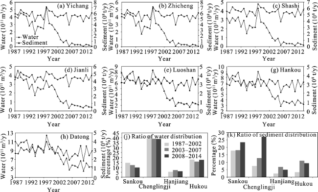
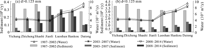
River basin reservoir construction affects water and sediment transport processes in downstream reaches. The downstream impact of the Three Gorges Projects (TGP) has started to become apparent: (1) reduction in flood duration and discharge, and significant reduction in sediment load. Although there was some restoration in downstream sediment load, the total amount did not exceed the pre-impoundment annual average; (2) in 2003-2014, the d > 0.125 mm (coarse sand) load was restored to some degree, and to a maximum at Jianli Station, which was mainly at the pre-impoundment average. After restoration, erosion and deposition characteristics of the sediment was identical to that before impoundment. The degree of restoration during 2008-2014 was less than during 2003-2007; (3) after TGP impoundment, there was some restoration in d < 0.125 mm (fine sand) sediment load, however, it was lower than the pre-impoundment average; (4) due to riverbed compensation, the d > 0.125 mm sediment load recovered to a certain degree after impoundment, however, the total did not exceed 4400×104 t/y. This was mainly limited by flood duration and the average flow rate, and was less affected by upstream main stream, tributaries, or lakes. Restoration of d < 0.125 mm suspended sediment was largely controlled by upstream main stream, tributaries, and lakes, as well as by riverbed compensation. Due to bed armoring, riverbed fine suspended sediment compensation capability was weakened; (5) during 2003-2007 and 2008-2014, Yichang to Zhicheng and upper Jingjiang experienced coarse and fine erosion, lower Jingjiang experienced coarse deposition and fine erosion, Hankou to Datong had coarse deposition and fine erosion, and Chenglingji and Hankou was characterized by coarse deposition and fine sand erosion in 2003-2007, and coarse and fine erosion in 2008-2014. This difference was controlled by flood duration and number at Luoshan Station.

Cite this article

ZHANG Wei , YANG Yunping , ZHANG Mingjin , LI Yitian , ZHU Lingling , YOU Xingying , WANG Dong , XU Junfeng . Mechanisms of suspended sediment restoration and bed level compensation in downstream reaches of the Three Gorges Projects (TGP)[J]. Journal of Geographical Sciences, 2017 , 27(4) : 463 -480 . DOI: 10.1007/s11442-017-1387-3

1 Introduction

Reservoirs and associated dams can have a tremendous effect on river runoff, changing the natural hydrological cycle and sediment transport processes in downstream reaches, especially with the powerful regulatory capacity of cascade reservoirs (Benn and Erskine., 1994). Reservoir operating rules differ on various rivers, as do the arrangement of tributaries and lakes, riverbed erosion, river adjustment, and other conditions. Moreover, there are differences in water discharge amounts in the same river throughout a year. There is some sediment load restoration along reaches downstream of the reservoir after its construction; however, the amount never exceeds the annual average before reservoir construction. Williams, et al. analyzed 21 reservoirs in the United States, with respect to sediment sources from erosion. They found that the proportion of sediments from the riverbed increases with proximity to the dam, while the proportion of sediments from the river bank and beach increases as distance from the dam increases (Williams and Wolman, 1984). After construction of the Danjiangkou Reservoir, during 1970-1979 and 1980-1985, different components of the sediment load were restored in reaches downstream of the dam. Due to a high water volume during 1980-1985, the level of restoration was higher than during 1970-1979, however, the total sediment load was still lower than the average before reservoir impoundment (HB, CWRC, 2002). After construction of the Sanmenxia reservoir on the Yellow River, sediments with grain size d < 0.05 mm were restored. Restoration of sediments with grain size 0.05 mm < d < 0.1 mm decreased after a certain distance downstream, and sediments with grain size d > 0.1 mm showed an increasing trend after Huayuankou, which was possibly due to the convergence of tributaries, choice of time period of study, and other factors (Chen et al., 2002). In summary, coarse and fine sands were restored to a certain degree in reaches downstream of the dam after reservoir construction. At certain stations, coarse sands were restored to a level similar to that before reservoir construction, and downstream sediment transport identical to that before reservoir construction. The degree of restoration of coarse and fine sand in reaches downstream of a dam is determined by total discharge and runoff processes, riverbed composition, tributaries and lakes, and other factors. Riverbed sediment compensation capability is dependent on riverbed composition, hydrodynamic power, erosion layer thickness, and other factors.
Since the impoundment of the Three Gorges Projects (TGP) in June 2003, a large data collection has accumulated and formed the basis of many research projects by Chinese scholars. In terms of total sediment load, there has been a decreasing trend in the middle and lower reaches of the Yangtze River (Dai et al., 2008, 2009). The reduction in sediment load gradually decreases toward the lower reaches, to the Hekou area (Yang et al., 2014a, 2015a). Based on data before TGP impoundment, it was predicted that riverbed erosion would occur, and that during the restoration process sediment load in the different grain size fractions would not exceed average values before TGP construction (Li et al., 2003). This prediction was verified by data collected after the TGP impoundment during 2003-2011 (Chen et al., 2010; Guo et al., 2014). Data from 2003-2007 showed that long distance erosion in downstream reaches was mainly due to a lack of riverbed compensation, especially for fine sand in the riverbed (Chen et al., 2010). During 2003-2011, sediment of grain size d < 0.125 mm was slowly restored along the middle reaches of the Yangtze River, however, the total amount was much less than the average before impoundment, which promoted long distance erosion. The load of grain size fractions d > 0.125 mm was restored relatively quickly, within 200 km downstream of the dam, which indicated that erosion mainly occurred in Jinjiang after the TGP impoundment (Guo et al., 2014). In terms of riverbed composition, there was a coarsening trend in the middle and lower reaches of the Yangtze River, which was most pronounced in reaches within 200 km of the dam (Luo et al., 2013). With the increased water level of the TGP, there is enhanced ability to regulate downstream flow. Changes in flow distribution during flood and dry seasons (Li et al., 2011), and in flow quantity and duration (Ban et al., 2014), could alter the sediment transportation capability of downstream water bodies. However, the impact of such flow changes on transport of different sediment size fractions sizes has not been adequately investigated in existing studies. Since impoundment, downstream riverbed composition has undergone constant adjustment. Riverbed compensation to suspended sediments has been limited by interchange of coarse and fine sands, and by flow. Meanwhile, lakes and tributaries in the middle and lower reaches of the Yangtze River also affect the amount of sediment transport in the main stream. In view of the above issues, for the period 1987-2014, in this study we investigate process and patterns of change in river runoff, sediment load, and suspended sediment composition at hydrologic stations along the main stream, tributaries, and lakes of the middle and lower reaches of the Yangtze River, and identify mechanisms of suspended sediment restoration and bed sand compensation.

2 Survey area and data sources

2.1 Survey area

The downstream reach of the TGP between Yichang and Datong is 1183 km in length, and riverbed composition can be classified as sand/gravel or sand. The reach between Yichang and Zhicheng (61 km) is mainly composed of sand/gravel; the reach from Zhicheng to Dabujie (56.4 km) is the transition region; and the section from Dabujie to Datong (1065.6 km) is sand bedded (Figure 1). The main stream reaches studied include Yichang, Zhicheng, Shashi, Jianli, Luoshan, Hankou, Datong, and other hydrologic stations. Also included in the study, are tributaries of Dongting Lake, the Songzikou River, Taipingkou River, and Ouchikou River, which are often called the Dongting Lake Three Outlets. The hydrologic stations at the confluences of Dongting Lake, Hanjiang, and Poyang Lake are Chenglingji Station, Huangzhuang Station, and Hukou Station, respectively.
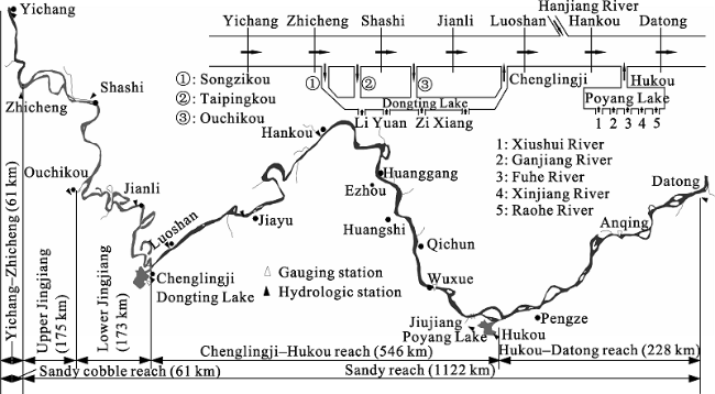
Figure 1 Location of the survey areas in downstream reaches of the Three Gorges Projects (TGP)

2.2 Data sources and time periods

A range of data was obtained for the time period 1987-2014, including hydrological sediment and suspended sediment grading data from the main stream, tributaries, and lakes downstream of the TGP, riverbed grain size and composition for the reach between Yichang and Datong, and total annual erosion and deposition for the reach between Yichang and Datong (Table 1). The study time period can split into two phases: the pre-impoundment period (1987- 2002) and post-impoundment period (2003-2014). During 2003-2007 cofferdam impoundment and initial impoundment took place, with a water level of 135-156 m. The impoundment water level reached 172.8 m in 2008 and was maintained at 175 m after 2009. The time period during 2008-2014 was termed the pilot impoundment period. Each time period was characterized by different degrees of flow regulation and sediment interception, which could help explain the impact on suspended sediment restoration and sand bed compensation downstream of the dam. The load of different sediment sizes was determined based on the amount of sediment with grain size greater than, less than, or between certain ranges on the sediment grading curve. A particle size of d = 0.125 mm was the criteria used to classify suspended sediment and sand bed in the middle and lower reaches of the Yangtze River.
Table 1 Source of hydrological and sediment data for middle and lower reaches of the Yangtze River
Number Hydrologic station Data Period Data source
1 Yichang, Zhicheng, Shashi, Jianli, Luoshan, Hankou, Datong Water discharge, sediment load, flow, suspended sediment and sand bed grading 1987-2014 Yangtze River Middle and Lower Reach Region Hydrological Yearbook
2 Songzikou, Tiapingkou, Ouchikou (Dongting Lake Three Outlets), Chenglingji, Hukou Water discharge, sediment load, flow, suspended sediment grading 1987-2014 Yangtze River Middle and Lower Reach Region Hydrological Yearbook;
Changjiang Waterway Planning Design and Research Institute
3 River reach between Yichang and Datong Typical river and section sand bed grading 2002-2014

2.3 Hydrological and sedimentological characteristics

Figure 2 shows changes in water flux and sediment load at hydrologic stations of Yichang, Zhicheng, Shashi, Jianli, Luoshan, Hankou, and Datong during 1987-2014. The maximum water flux at each hydrologic station occurred in 1998 and the minimum in 2006. The average water flux during 2003-2014 was lower than that during 1987-2002, with a reduction of 5%-10%. The flow split at the Three Outlets showed a decreasing trend; the inflow from Chenglingji at Luoshan Hydrologic Station reduced, the inflow from Hanjiang at Hankou Hydrologic Station first decreased and then increased, and the ratio of inflow from Poyang Lake at Datong Hydrologic Station first decreased and then increased. The overall sediment load at each station showed a decreasing trend, with a 58%-90% reduction in 2003-2014 as compared to 1987-2002. Yichang Station had the largest reduction, and the sediment load reduction decreased downstream. Sediment flux at Dongting Lake Three Outlets decreased, a large portion of the sediment flux at Luoshan Station was from Chenglingji Station, the sediment flux from Hanjiang at Hankou Station first increased and then decreased, the sediment flux from Poyang Lake at Datong Station also increased first and then decreased.
Figure 2 Variation in water and sediment flux in the middle and lower reaches of the Yangtze River
Water flux and sediment load in downstream reaches of TGP are subject to the influences of rainfall, urban water consumption, TGP, other dams, soil and water conservation, and other factors (Yang et al., 2015b). After due to TGP impoundment, during 2003-2005, 2006-2007, and 2008-2012, sediment flux at Yichang Station reduced by 63%, 84%, and 87%, respectively, compared to before impoundment. The reduction at Hankou Station was 43%, 58%, and 59%, respectively, and at Datong it was 35%, 45%, and 49% (Yang et al., 2014b). Compared to the 1993 to 2002 period, the contribution of rainfall, urban water consumption, the TGP, other dams, and soil and water conservation to water flux reduction was 61%, 2%, 3%, 5% and 9%, respectively, during 2003-2012. Their contribution to sediment flux reduction was 14%, 1%, 65%, 10%, and 10%, respectively, during 2003-2012 (Yang et al., 2015b). In extremely dry years like 2006, downstream water reduction was more pronounced due to reduced rainfall, as was the decrease in sediment flux. As a result, 2006 was the year with the lowest water and sediment flux since TGP impoundment (Dai et al., 2011). In summary, rainfall contributed the most to water reduction, and retention of sediment by TGP contributed most to the reduced sediment load.

3 Restoration of suspended sediment in the downstream reaches of the TGP

3.1 Median suspended sediment size

Variations in median sediment size at hydrologic stations along the main stream, tributaries, and downstream of the TGP are shown in Figure 3. The main trends are:
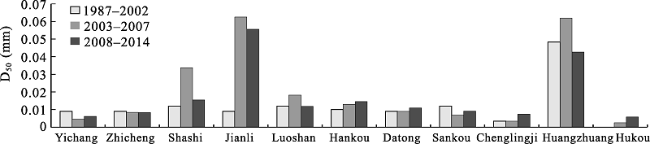
Figure 3 Variations in median suspended sediment size in downstream reaches of the TGP (1987-2014)
• Yichang Station: increase first and then decrease
• Zhicheng Station: slight decrease
• Shashi, Jianli and Luoshan stations: increase first and then decrease
• Hankou Station: increasing
• Datong Station: slight increase
• Dongting Lake Three Outlets: increase first and later decrease
• Chenglingji Station: increasing
• Huangzhuang Station: increase first and later decrease; change much greater than at Luoshan and Hankou stations.
Water flow and sediment transport from Hanjiang accounts for a small proportion of those at Hankou Station. Meanwhile, between Huangzhuang Station and the estuary suspended sediment composition was under constant adjustment, with coarse sand deposition and fine sand erosion (Han, 2003). However, the total sediment load from Hanjiang was relatively small, so it only had a small effect on suspended sediment sizes in the main stream. Median suspended sediment diameter at Hukou Station was less than 0.006 mm, and the proportion of suspended sediment with grain size d > 0.125 mm was only 1.23%. The small grain size of suspended sediments from Poyang Lake indicates that they did not contribute to bed formation processes; the sediments would be transported downstream to Datong Station within the water, causing the median suspended sediment diameter to be slightly smaller at Datong Station than that at Hankou Station.

3.2 Restoration of suspended sediment composition

Figure 4a shows that during 2003-2014, the annual average sediment load for d > 0.125 mm was lower than during 1987-2002. During 2003-2007, sediment load significantly decreased at Yichang Station, changed little at Jianli Station, and was higher than that before impoundment at Luoshan Station and Hankou Station in some cases. This indicates that the d > 0.125 mm sediment load was completely restored between Jianli Station and Hankou Station. For the same period, there was a decrease at Datong Station. During 2008-2014, d > 0.125 mm sediment load showed a decreasing trend between Yichang Station and Hankou Station, and slightly increased at Datong Station. We then analyzed the relationship between water flux and d > 0.125 mm suspended sediment load during 2008-2014 and 2003-2007. We found that water flux during 2003-2007 was lower than that during 2008-2014, however, d > 0.125 mm suspended sediment load showed the opposite pattern (except for Datong Station). This suggests that the total amount of water was not the major factor affecting sediment load variations.
Figure 4 Suspended sediment (d < 0.125 mm and d > 0.125 mm) transport in downstream reaches of the TGP
Figure 4b shows relatively large d < 0.125 mm sediment load during 1987-2002, with first increasing and then decreasing. Differences in sediment load after the establishment of Jianli Station were small. During 2003-2007 and 2008-2014, d < 0.125 mm sediment load showed an increasing trend. The sediment load during 2008-2014 was lower than that during 2003-2007. Overall, d < 0.125 sediment load during 2003-2007 and 2008-2014 was lower than that during 1987-2002, which is consistent with observations worldwide that sediment load downstream of dams is lower than that before impoundment.

3.3 Relationship between the sediment load of different size fractions and flow flux

The relationship between monthly average flow flux and sediment load in 1987-2002, 2003-2007, and 2008-2014 is shown in Figure 5. Sediment load slightly decreased during the dry season, and increased with flow flux, but showed an overall decrease over time. Total water discharge in 2008-2014 was higher than that in 2003-2007. However, both the d > 0.125 mm and d < 0.125 mm sediment load showed a decreasing trend, which is contradictory. Since flow flux was adjusted in the downstream reaches of the TGP within a year after the impoundment, its impact on sediment load needs to be fully considered.
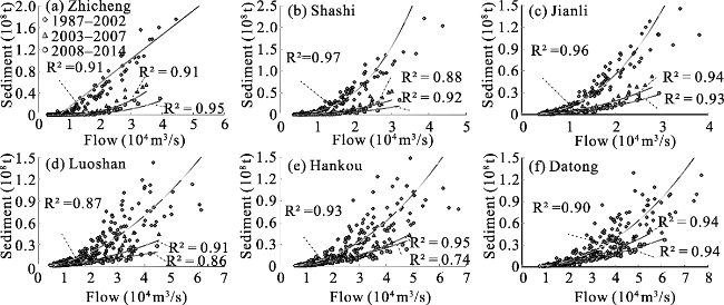
Figure 5 Relationship between monthly sediment load and flow flux in downstream reaches of the TGP
The relationship of monthly average flow and d > 0.125 mm sediment load at each main stream hydrologic station at the downstream of the TGP was fitted using a power function (Figure 6a). The results demonstrate that the d > 0.125 mm sediment load in reaches between Zhicheng and Jianli was gradually restored with the increase in discharge, and increased downstream. Moreover, the larger the flow flux, the higher the degree of restoration. Reaches between Jianli and Hankou were affected by inflow from Dongting Lake. The d > 0.125 mm sediment load at Chenglingji Station was very small, 250,000 t during 2003-2009, which was negligible in terms of total river sediment load. Therefore, with the same monthly average flow flux, d > 0.125 mm sediment load at Luoshan Station was lower than that at Jianli Station. The relationship between d > 0.125 mm sediment load and flow flux at Hankou Station was identical to that at Luoshan Station. In the section of the Yangtze River between Hankou and Datong, sediment from Poyang Lake was mainly composed of fine sand. During 2009-2014, the total d > 0.125 mm suspended sediment load at Hukou Station was 94.46×10⁴ t (yearly average 15.74×10⁴ t). Its contribution to the total sediment load at Datong Station was insignificant. Due to the inflow of Poyang Lake into the Yangtze River, flow discharge increased at Datong Station and sediment of the d > 0.125 mm size group deposited. The combined effect was that the coarse sand sediment load was lower at Datong Station than at Hankou Station. The relationship of monthly average flow flux and the d < 0.125 mm sediment load at each main stream hydrologic station downstream of the TGP was fitted using a power function (Figure 6b). The results show that the sediment load of this size group increased in river reaches between Zhicheng and Jianli, suggesting that it was significantly restored under different flow regimes. Also, the d < 0.125 mm sediment load showed an increasing trend with the increase in flow flux at each station. Considering river reaches between Jianli and Hankou, the d < 0.125 mm sediment load at Luoshan Station was significantly lower than that at Jianli Station due to the convergence at Dongting Lake. Because of the inflow from Hanjiang, most of the data points of d < 0.125 mm sediment load at Hankou Station lie below those at Luoshan Station. For river reaches between Hankou and Datong, due to the convergence at Poyang Lake, sediment inflow was mainly composed of fine sand with d < 0.125 mm. Sediment load at Hukou Station was lower than that at Hankou Station. Due to riverbed compensation and convergence at lakes, the d < 0.125 sediment load at Datong Station was higher than that at Hankou Station.
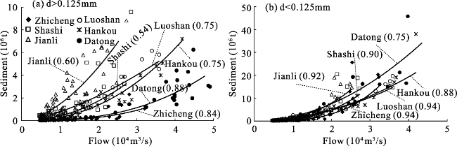
Figure 6 Relationship between sediment load (grain sizes d > 0.125 mm and d < 0.125 mm) and flow flux in the middle and downstream reaches of the TGP

3.4 The influence of flow flux on the restoration of suspended sediment

Since sediment transport in the middle and lower reaches of the Yangtze River mainly occurs in the flood season, and coarse sand transport is concentrated during the high flow period, changes of flow during the year need to be further investigated. Flood discharge varies in different sections of the middle and lower reaches of the Yangtze River. We chose flood discharge thresholds (where Q is discharge) of Q≥2.5×10⁴ m3/s for the section between Yichang and Jianli, Q≥3.0×10⁴ m3/s at Luoshan Station, Q≥3.5×10⁴ m3/s at Hankou Station, and Q≥4.5×10⁴ m3/s for Datong Station. During 2008-2014, the average flow above the thresholds downstream of the dam was less than that of 2003-2007, which reduced sediment transport capability during the flood season. Meanwhile, the flood duration at each station (except Luoshan and Datong) showed a decreasing trend. The combined effect was that the d > 0.125 mm sediment load during 2008-2014 was lower than 2003-2007 (Figure 7).
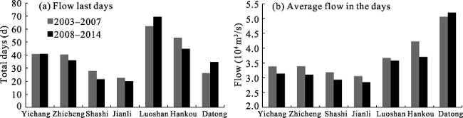
Figure 7 Variations in flood flow and duration at hydrologic stations in downstream reaches of the TGP
The d < 0.125 mm sediment in the middle and lower reaches of the Yangtze River mainly comes from upper basin, tributary inflow, and riverbed compensation. Using the sediment load at Yichang Station to represent incoming sediment load, sediment at Zhicheng contributed to the load increase. Downstream of Zhicheng, the proportion of d < 0.125 mm sediment to the total sediment at Yichang Station decreased no matter whether there were tributary or lake inputs (Figure 8). During the time periods 2003-2007 and 2008-2014, changes in d < 0.125 mm suspended sediment transport were as follows:
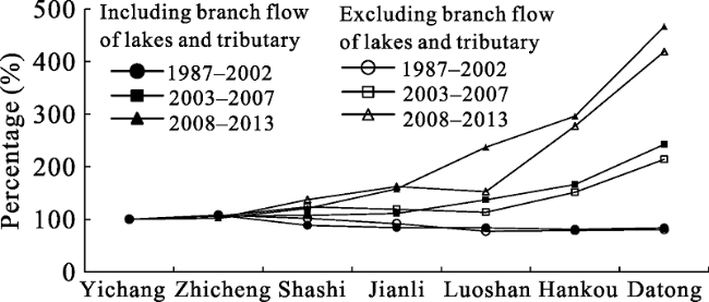
Figure 8 Suspended sediment (d < 0.125 mm) compensation from tributaries and lakes in the downstream reaches of the TGP
• a slight increase from Yichang to Zhicheng, which was consistent with that in 1987-2002, before impoundment
• a trend of restoration from Zhicheng to Jianli, which might have been larger if there were no water diversion at Dongting Lake Three Outlets
• a trend of restoration from Jianli to Datong, which was higher during 2008-2014 than during 2003-2007
The amount of d < 0.125 mm sediment at Yichang Station decreased substantially during 2008-2014. Riverbed compensation in the main stream reaches played a positive role in the restoration of sediments. However, the annual average sediment load during 2008-2014 was still lower than 2003- 2007.

4 Mechanism of riverbed compensation in downstream reaches

4.1 Change in sediment grain size

Figure 9 shows variations in median grain size. There was a coarsening trend in the years 2003, 2007, and 2010, with the greatest degree of coarsening in reaches between Yichang and Zhicheng. There was a universal coarsening in reaches between Zhicheng and Luoshan, the degree of which decreased downstream. Reaches downstream of Luoshan Station showed an overall coarsening trend, but with alternating coarsening and fining. In general, riverbed armoring is not conducive to the sediment restoration of sizes d > 0.125 mm or d < 0.125 mm.
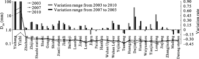
Figure 9 Variations in median size of bed sands in downstream reaches of the TGP

4.2 The riverbed compensation process

Figure 10 shows bed load variations in downstream reaches of the TGP. The d < 0.125 mm component near the dam showed a decreasing trend and was close to zero in reaches from Yichang to Zhicheng. This indicates that the compensation for suspended sediment from the d < 0.125 mm component in the riverbed decreased, and the riverbed might no longer provide compensation. As a result, the d < 0.125 mm sediment load in the same reach showed a decreasing trend, and did not return to the average pre-impoundment level. Although the percentage of the d < 0.125 mm component in the riverbed downstream of Zhicheng decreased, the ratio was still above 10% and the riverbed could still compensate for suspended sediment. Therefore, the percentage of the d < 0.125 mm component of the riverbed in downstream reaches decreased after impoundment. If the amount of incoming sediment from upstream reaches continued to keep at a low level, suspended sediment load could still be restored to a certain degree along downstream reaches, but it would be hard to return to the average pre-impoundment level. The percentage of the d > 0.125 mm component showed an increasing trend (Figure 10). Compensation by this riverbed component depends on flood flow and duration. As both flood flow and duration in downstream reaches of the TGP showed a decrease, sediment compensation from this component group would be reduced and its total load would further decrease.
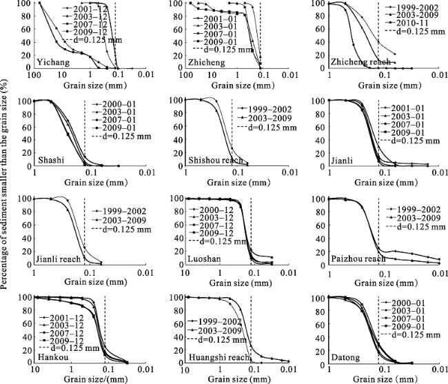
Figure 10 Variations in bed surface load (%) in the downstream reaches of the TGP
Since the water flow was under unsaturated conditions, the riverbed surface would undergo gradual erosion to compensate for suspended sediment. However, the amount and capability of the compensation are limited by the hydrodynamic strength and composition of the bed surface. The amount of compensation is also limited by the thickness of the scourable layer of the riverbed. The reach from Yichang and Zhicheng is of sand/gravel type. It can be seen from Figure 11 that the d < 0.125 mm component is close to zero. Data from 2009 show that the 0.125 mm < d < 0.5 mm components of the riverbed were all scoured away. As a result, suspended sediment compensation from the riverbed between Yichang and Zhicheng was very small. Although there was compensation from coarse sand, compensation from river channels was depleted. Figure 11c shows variations in sediment and sand/gravel top layer in the sand/gravel-sand transition reach between Zhicheng and Changmen (Lujiahe is at the end of the sand/gravel river reach). The scourable layer of the bed surface was thin before impoundment, with a large amount of sand and gravel in deeper layers. With continuous erosion of the reach, compensation from the deep sand/gravel layer decreased. Although the thickness of the riverbed scourable layer in Lujiahe reach became zero after the appearance of deep grooves, the scouring layer of the riverbank was still significant. In the reach between Zhicheng and Lujiahe, both d > 0.125 mm and d < 0.125 mm suspended sediment were restored. After impoundment, there were frequent riverbank collapses along the Jinjiang reach (Xia et al., 2014), which further demonstrated that the sediment compensation was from riverbank erosion. In the reach between Zhijiang and Jiangkou, the thickness of the main channel sand/gravel cover layer decreased, and scourable layer thickness increased. In recent years, there has been thalweg incision and decrease in the sand layer above the gravel layer. Therefore, there will be a shortage for suspended sediment compensation. The deep incision of the sandy scouring layer of reaches at Shashi was less than 10 m, and the sandy cover layer of the bank and river was still relatively thick. Hence, coarse sand compensation was still abundant in the sandy river beach.
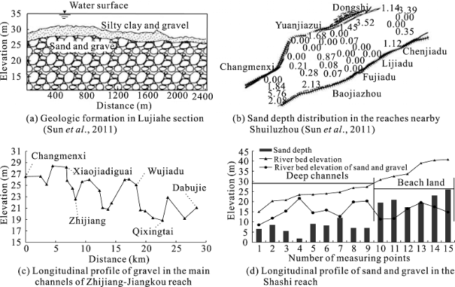
Figure 11 Geological composition of the riverbed in the middle reaches of the Yangtze River

4.3 Relationship of riverbed adjustment and suspended sediment restoration with riverbed compensation

Downstream reaches of the TGP comprise: Yichang to Zhicheng, Upper Jingjiang (Zhicheng to Ouchikou), lower Jingjiang (Ouchikou to Chenglingji), Chenglingji to Hankou, Hankou to Hukou, and Hukou to Datong. Channel erosion and deposition intensity per unit river length in the above river reaches is shown in Figure 12. The main conclusions are as follows:
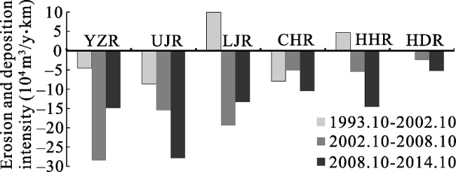
Figure 12 Variations in erosion and deposition intensity in downstream reaches of the TGP
Yichang to Zhicheng reach (YZR). Erosion was recorded in four periods of 1987-2002, 2003-2007, and 2008 -2014. Erosion intensity was higher after impoundment than before, and was weaker in 2008-2014 than 2003-2007. The main reason was the great degree of armoring of the sand/gravel riverbed. As a result, the d < 0.125 mm sediment component of the riverbed was almost zero, causing a shortage in the suspended sediment compensation for this size group. Meanwhile, both the duration and average flood discharge were decreased, leading to reduced erosion of the d > 0.125 mm component of the riverbed. Therefore, the suspended sediment compensation capacity of the riverbed for this size range was reduced, which also contributed to erosion.
Upper Jingjiang reach (UJR), between Zhicheng Station and Jianli Station. Riverbed erosion intensity showed an increasing trend and d > 0.125 mm suspended sediment was gradually restored. The divergence and convergence at Dongting Lake had little effect on suspended sediment restoration of this size group, indicating that the increase in d > 0.125 mm sediment load in this reach was mainly from riverbed erosion. The d < 0.125 mm sediment was also gradually restored, suggesting that there was erosion of both coarse and fine sand from the riverbed in the upper Jingjiang reach. This made it a region with concentrated, and relatively high degree, of erosion compared to other reaches after impoundment.
Lower Jingjiang Reach (LJR), between Jianli Station and Luoshan Station. The degree of suspended sediment restoration decreased. During 1987-2002, 2003-2007, and 2008-2014, the d > 0.125 mm sediment load at Luoshan Station was lower than that at Jianli Station. Deposition of d > 0.125 mm sediment occurred during all three time periods, suggesting that this fraction was restored to a level similar to that before impoundment. There is convergence of tributaries at Dongting Lake. The differences in d < 0.125 mm sediment load in reaches between Luoshan Station, Chenglingji Station and Jianli Station were -2680×104 t/y, 150×104 t/y, and 60×104 t/y during 1987-2002, 2003-2007, and 2008-2014, respectively. Thus, the pattern changed from erosion and deposition before impoundment, to just erosion after impoundment. In the lower Jingjiang reach, both coarse and fine sand showed erosion and deposition in 1987-2002, but this changed to coarse sand deposition and fine sand erosion in 2003-2007 and 2008-2014. A shortage in fine sand compensation was due to the reduced flood discharge and duration at Jianli Station, and riverbed armoring. The combined effect was that erosion intensity in the lower Jingjiang reach was lower during 2008-2014 as compared with 2003-2007.
Chenglingji to Hankou reach (CHR), between Luoshan Station and Hankou Station. The trend here was for riverbed erosion in 1987-2002, 2003-2007, and 2008-2014. The d > 0.125 mm component of suspended sediments showed a trend of erosion in 1987-2002, deposition in 2003-2007 and erosion in 2008-2014. The number and duration of Q > 35000 m3/s floods increased during 2008-2013 as compared to 2003-2007, which changed the characteristics of erosion and deposition during the two time periods. This is different from the findings in previous studies, and is mainly due to the fact that data used in previous studies were from 2007 and earlier (Chen et al., 2010), or data from 2003-2011 were analyzed as a whole (Guo et al., 2014), which minimized the impact of flow flux. When the erosion/deposition relationship is calculated at Hankou Station, the inflow from Hanjiang needs to be taken into account as the confluence of the Hanjiang River is located 1.15 km above the Station. Therefore, the sediment load from Hanjiang into the Yangtze River at Huangzhuang Station needs to be excluded from sediment balance calculations in the river reaches between Chenglingji and Hankou. The differences of d < 0.12 5 mm sediment load at Hankou, Hanjiang Huangzhuang and Luoshan Stations during 2003-2007 and 2008-2014 were -1890×104 t/y, 890×104 t/y, and 1240×104 t/y, respectively. The trend was for erosion and deposition before impoundment, changing to just erosion after impoundment. The pattern of erosion and deposition in reaches from Chenglingji to Wuhan was coarse sand erosion and fine sand deposition in 1987-2002 before impoundment, changing to coarse sand deposition and fine sand erosion in 2003-2007, and coarse and find sand erosion in 2008-2014. This led to variations in erosion and deposition of both coarse and fine sands. Due to the impact of combined flow flux at Dongting Lake and the main stream Yangtze River, flood duration increased at Luoshan Station, but with a slightly lower average flow level. As a result, the total flood season water discharge had an increasing trend. This increased erosion power, which caused the transition from “coarse sand deposition fine sand erosion” in 2003-2007 to “both coarse and fine sand erosion” in 2008-2014. Due to the increase in flood discharge at Luoshan Station, and the sandy riverbed from Chenglingji and Hankou, there was sufficient sediment compensation from the riverbed. Therefore, erosion intensity was higher during 2008-2014 than during 2003-2007.
Hankou to Datong reach (HDR), between Hankou Station and Datong Station. The period 1987-2002 showed a small scale deposition trend, and the scouring intensity during 2008-2014 was higher than that during 2003-2007. As sediment from Poyang Lake is mainly composed of fine suspended sediment, it was excluded from erosion and deposition calculations of d > 0.125 mm sediment between Hankou and Datong. The differences in d > 0.125 mm suspended sediment load at Datong Station, Hukou Station and Hankou Station were 100×104 t/y, -1800×104 t/y, and -700×104 t/y, respectively, in 1987-2002, 2003-2007, and 2008-2014. The pattern was small scale erosion before impoundment, becoming erosion and deposition after impoundment. As for the change of erosion and deposition of d > 0.125 mm suspended sediments, previous research has shown that the d > 0.125 mm sediment deposition was caused by the decrease in runoff after impoundment (Chen et al., 2010). The differences in d < 0.125 mm suspended sediment load at Datong Station, Hukou Station, and Hankou Station were -130×104 t/y, 2950×104 t/y, and 3120×104 t/y during 1987-2002, 2003-2007, and 2008-2014. The trend was for small scale deposition before impoundment and erosion after impoundment. In general, erosion and deposition of sediments in river reaches from Hankou to Datong was minor before impoundment, and kept in balance. After impoundment, it changed to erosion. We used the sediment balance method to calculate erosion and deposition intensity in reaches from Hankou to Datong. Average annual erosion and deposition during 1987-2002, 2003-2007, and 2008-2014 was -600×104, 1200×104, and 2100×104 t/y, respectively. Erosion was higher during 2008-2014 than 2003-2007, which corresponds to the period of erosion intensity associated with the geological composition of the riverbed. There were clear differences in erosion intensity in reaches between Hankou to Hukou and Hukou to Datong. From Hankou to Hukou, fine sand erosion had, to a certain degree, been restored. Inflow of fine sand from Poyang Lake increased the amount of sediment in unsaturated water in reaches from Hukou to Datong, which reduced riverbed erosion intensity. Under their combined influences, erosion and deposition intensity was lower from Hukou to Datong than from Hankou to Hukou.
From the above analysis, it can be seen that there was a good correlation between the amount of sediment and riverbed erosion and deposition intensity in reaches between Yichang and Datong. Combined with post-impoundment changes in flood amount and duration, erosion and deposition variations during 2003-2007 and 2008-2014 could be explained. However, there were relatively large differences between the amount of sediment erosion and deposition and the amount of riverbed erosion and deposition. This was probably caused by the combined effect of instream sand mining, waterway dredging, and other factors. Instream sand mining can, to a certain extent, exacerbate riverbed erosion, channel widening, and stream gradient adjustment. The “keeping fine sand and leaving gravel” technique in operation during sand mining accelerates the process of sand bed coarsening (Hu et al., 2015). Instream sand mining data in the main stream reaches of the Yangtze River for 2003-2011 is summarized in Table 2. It can be seen that sand mining had a large impact, for example, it accounted for 63.2% of the total sediment load at Datong Station in 2009. However, not all sand mining was below the bankfull channel, and its proportion will decrease. In addition, the river waterway departments in the middle and lower reaches of the Yangtze River conducted large scale dredging. The amount of dredging was relatively large, even during the unfavorable years (Table 3). Due to the impact of sand mining and dredging, riverbed erosion and deposition intensities calculated using topographic survey and discharge balance methods were not consistent, and could be quite different.
Table 2 Annual sand mining limits in the middle and lower reaches of the Yangtze River (Wang et al., 2014)
Year 2004 2005 2006 2007 2008 2009 2010 2011
Sand mining controlled amount (104 t) 1186 1602 1240 1690 5140 7020 4430 4407
Table 3 Dredging amounts in the Yichang-Datong section (Huang et al., 2015)
Year 2008 2009 2010 2011 2012 2013
Dredging amount (104 m3) 25.9 69.9 51.5 466.7 147.5 608.9

4.4 Discussion on the trend of sediment load change in middle and lower reaches of the TGP after the operation of cascade reservoirs

TGP intercepts a large amount of sediment. Clear water discharge causes water bodies downstream of the dam to be under long-term unsaturated conditions. Due to the restoration of suspended sediments, reaches downstream of the dam are under long-term erosion. Fine sand in the riverbed of the reaches between Yingchang and Zhicheng was completely washed away. The coarse grain transport capacity, especially of gravel, was weakened due to the reduced flood discharge. Meanwhile, the surface gravel layer concealed the underneath riverbed, which enhanced the anti-erosion capability of the riverbed. Large or catastrophic floods promote coarse sand transport and increase riverbed erosion intensity, although with limited transport distance. In sandy river reaches, there is a large amount of d > 0.125 mm coarse sand and a limited amount of d < 0.125 mm fine sand in the riverbed. As a result, the restoration of fine suspended sediments in sandy river reaches is limited. Although d > 0.125 mm suspended sediment recovery was relatively fast, recovery was lower during 2008-2013 compared with 2003-2007. Upper Jingjing reaches experienced the largest erosion during 2003-2007. Erosion had advanced to the downstream reaches in 2008-2014; preliminary findings showed erosion had reached the lower Jingjiang region. With cascade reservoirs in the upper reaches of Changjian being put into operation successively, it will further exacerbate clear water discharge. As time goes by, the area of major erosion will move to downstream reaches. Because of the large amount of d > 0.125 mm sediments in the sandy river reaches, the d > 0.125 mm sediment load will continue to recover. However, due to flow leveling, especially the relative decrease in flood duration and amount, the sediment load of this size group will decrease. According to a recent plan, the TGP will implement small and medium flood regulation, which could further increase the flow leveling amplitude (Zheng, 2015). The d > 0.125 mm suspended sediment showed a relatively large degree of restoration at Jianli Station, Luoshan Station, and Hankou Station. The largest sediment load was observed at Jianli Station. Therefore, Jianli Station was chosen as representative hydrologic station for predicting downstream coarse sediment load after the joint operation of the TGP and upstream cascade reservoirs. During 2003-2004, the maximum d > 0.125 mm sediment load at Jianli Station was 5300×104 t/y. Using the difference between Yichang Station and Shankou Station as the riverbed supply amount between Yichang and Jianli, the maximum sediment compensation was calculated at 4400×104 t/y, with an average of 3000×104 t/y (Figure 13). In summary, after the operation of TGP and upper stream cascade reservoirs, the maximum d > 0.125 m suspended sediment load did not exceed 5300×104 t/y in the middle and lower reaches of the Yangtze River due to the impact of small and medium flood regulation by TGP, riverbed coarsening, and other factors. Because of the substantial decrease in d > 0.125 mm sediment in the riverbed, riverbed compensation did not exceed 4400×104 t/y (annual average from 2003- 2007).
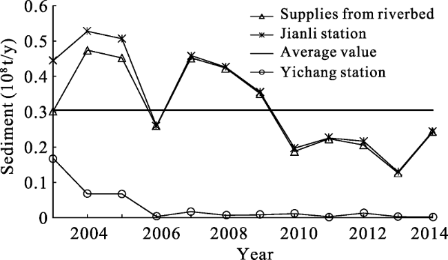
Figure 13 Changes in sediment with grain size d > 0.125 mm in the Yichang to Jianli reach from 2003 to 2014

5 Conclusions

The effect of the TGP impoundment on sediment load in downstream reaches has become apparent. In this paper, we analyzed data from 1987-2014 for the middle and lower reaches of the Yangtze River, and revealed mechanisms of suspended sediment restoration and riverbed compensation. The main conclusions are as follows:
(1) After the TGP impoundment, flood duration and amount were substantially reduced in downstream reaches. Sediment load was close to clear water discharge, and gradually restored along the downstream reaches over time. However, the sediment load did not exceed the annual average before impoundment.
(2) During 2003-2014, the d > 0.125 mm suspended sediment in downstream reaches recovered to a certain degree. The level of restoration was the highest at Jianli Station, which was close to the pre-impoundment level, and erosion and deposition characteristics were consistent to that before impoundment. The degree of recovery was lower during 2008-2014 than during 2003-2007.
(3) In 2003-2007 and 2008-2014, the d < 0.125 mm suspended sediment load in downstream reaches of the TGP was restored to a certain degree. However, the total amount did not exceed the average amount before impoundment. The level of restoration during 2008-2014 was lower than during 2003-2007.
(4) The restoration of d > 0.125 mm sediment mainly came from riverbed erosion after the TGP impoundment. However, the supply did not exceed 4400×104 t/y, which was limited by average flood flow and duration. The effect of upper reach main stream, tributaries, and lakes was less important. The restoration of d < 0.125 mm suspended sediments was controlled by upper reach main stream, tributaries, lakes, and riverbed compensation. Due to armoring, the riverbed compensation capability for suspended sediments decreased.
(5) After TGP impoundment, the d > 0.125 mm and d < 0.125 mm sediment erosion and deposition characteristics varied in different river reaches. During the time periods of 2003-2007 and 2008-2014, the Yichang to Zhieng reach in upper Jingjiang recorded coarse and fine sand erosion, lower Jingjiang recorded coarse sand deposition and fine sand erosion. Chenglingji to Hankou was characterized by coarse sand deposition and fine sand erosion in 2003-2007, and erosion in 2008-2014. This difference was controlled by flood amount and duration at Luoshan Station. The Kankou to Datong reach recorded coarse sand deposition and fine sand erosion.

The authors have declared that no competing interests exist.

[1]
Ban Xuan, Jiang Liuzhi, Zeng Xiaohui et al., 2014. Quantifying the spatio-temporal variation of flow and sediment in the middle Yangtze River after the impoundment of the Three Gorges.Advances in Water Science, 25(5): 650-657. (in Chinese)In the present work,spatial and temporal changes of hydrological regime in the middle reaches of the Yangtze River after the impoundment of the Three Gorges Project were quantitatively evaluated,which provides a scientific evidence for the ecological protection of the middle reaches of the Yangtze River and regional water resources management. The range of variability approach was used to analyze average daily data for discharge and sediment concentration from five hydrological stations on the stem stream of the Yangtze River. Thus,river sections with the maximum water and sediment variation degree in the middle reach of Yangtze River and hydrological index categories and their corresponding ecological effects after the impounding of Three Gorges Project were quantitatively evaluated. The results showed that the changes of sediment concentration downstream were far greater than that of discharge after the impounding of the Three Gorges Project,which had a large scale decline compared with that of before the impounding except for Chenglingji station. Decrease range of sediment concentrations in Yichang station attained to one order of magnitude. The regulations of Dongting Lake on sediment concentration were obvious. Variation of discharge decreased with the increase of the distance from the dam,with a decrease of flow obvious between July and November.These changes in hydrological regime will affect both the fish-spawning habitat downstream and the growth of the aquatic organisms in the retarding area and the surrounding vegetation.

[2]
Benn Patrick C, Erskine Wayne D, 1994. Complex channel response to flow regulation: Cudgegong River below Windermere Dam, Australia. Applied Geography, 14(2): 153-168. doi: 10.1016/0143-6228(94)90058-2.Windamere Dam is located on the Cudgegong River near Mudgee, Australia, and was built for irrigation and town water supply. It is operated in a similar manner to the other large irrigation dams in New South Wales. The response of the Cudgegong River to flow regulation since dam closure in February 1984 was determined for 13 km of river downstream of the dam where the channel is a bedrock-confined gravel-bed stream. Mean daily flows for durations less than 70 per cent have been reduced by between 20 and 73 per cent and those for durations greater than 70 per cent have been increased by between 58 and 496 per cent. The dam has reduced downstream flood magnitudes for all recurrence intervals by between 57 and 72 per cent. The dam's sediment trap efficiency is estimated at greater than 95 per cent of the incoming sediment load. Complex river response was induced by flow regulation, and included simultaneous channel contraction, degradation, aggradation, accommodation adjustment, formation of tributary-mouth bars and in-channel benches, and massive vegetation encroachment at different locations. Mean bed-material size decreased at all aggrading sites. Regulated flows are incompetent for the transport of the bed material but large floods generated in unregulated tributaries below the dam exceed the threshold of motion at channel constrictions. These unregulated tributaries now supply the majority of sediment to the channel. This material is reworked by dam releases which preferentially remove the fines and deposit them in downstream pools and on in-channel benches. Vegetation has invaded these recent deposits.

DOI

[3]
Chen Fei, Li Yitian, Tang Jinwu et al., 2010. Analysis of group-sized sediment transports downstream a reservoir.Journal of Hydroelectric Engineering, 9(1): 164-170. (in Chinese)Analysis and comparison of the field data of group-sized sediment transport for the two cases before and after the dam construction show a great difference of coarse particle transport in different reaches.In the natural river case,deposition of coarse particles is often caused by a dramatic decrease of flow velocity in some reaches,while in the case of reservoir operation the erosion of nearly all sizes of sediment are a consequence of supply shortage from the bed.In the reach closer to the dam site the erosion is more serious than the reaches far from the dam.In a reach far enough,the transport of some size groups will be similar to that of a natural river if the supply from the upstream is sufficient, as these groups are easily saturated.Long-distance erosion downstream a reservoir is caused by shortage of the supply from riverbed,particularly shortage of fine particles.

[4]
Chen Jianguo, Zhou Wenhao, Yuan Yuping, 2002. Transportation and adjustment of different grain sized sediment along the Lower Yellow River under typical operation modes of Sanmenxia Reservoir.Journal of Sediment Research, (2): 15-22. (in Chinese)The degradation and aggradation of the Lower Yellow River are affected by the operation modes of the Sanmenxia Reservoir. Under the influences of clear water or water of low sediment concentration released from the reservoir, the channel of the Lower Yellow River was eroded and the sediment concentration was recovered, but the concentration of fine sediment recovered slowly in a long distance, while the coarse and medium sediment recovered fast in a rather short distance. When the reservoir was flushed, the Lower Yellow River was serious silted because of the low discharge, high sediment concentration and coarse sediment sluiced from the reservoir. The quantity of siltation accounted for 60%~70% of the incoming sediment load, in non\|flood season, the channel of the Lower Yellow River was eroded by clear water from the reservoir. The eroded sediment from the channel bed was relatively coarse in the reach upstream of Huayuankou. The eroded coarse and medium sediment accounted for 30%~40% respectively with the median size of 0 04mm. The erosive distance was increased with the increasing of discharge. After the Spring flood, the capabilities of sediment transport for different sized sediment were decreased because of the armouring of the composition of the channel bed, and the quantities of eroded sediment were also decreased correspondingly. When the reservoir was flushed in pre\|flood season, the grain size of flushed sediment was 0.005~ 0.042mm. The deposition mainly occurred in the reach upstream of Huayuankou. The quantities of deposition for different sized sediment were determined by the incoming sediment and were not related to the incoming discharge. The grain size also was a significant factor affecting the quantities of deposition.

DOI

[5]
Dai S B, Lu X X, Yang S L et al., 2008. A preliminary estimate of human and natural contributions to the decline in sediment flux from the Yangtze River to the East China Sea.Quaternary International, 186(1): 43-54. doi: 10.1016/j.quaint.2007.11.018.This paper attempts to give a comprehensive explanation of the sediment discharge decrease from the Yangtze River to the East China Sea, taking into consideration its large scale and the basin wide complexity of changing human activities and precipitation. We examined various influencing factors include climate change, water and soil conservation measures, sand dredging, floodplain deposition and channel erosion, and dam construction. Correlation/regression analysis was used to examine the relations between data such as precipitation and water discharge, erosion or deposition in the river channel and sediment supply from the river basin. The sediment and water discharge of two major stations (Yichang and Datong) on the main river and 13 stations of the major tributaries were provided. The average precipitation in each tributary and its relationship with the water and sediment discharge were examined, and contributions of water and soil conservation measures, sand dredging, floodplain deposition and channel erosion, and dam construction to the sediment decrease were discussed. A quantitative estimation of the contribution of each impact factors to the sediment decline was attempted. Dam construction was the dominant factor ( 88%) contributing to the decline in sediment influx, followed by the water and soil conservative measures (15 5%). Climate change is responsible for a slight increase in sediment influx, approximately 3%. Floodplain deposition and channel erosion had an adverse effect, and the contribution of sand dredging was very limited.

DOI

[6]
Dai S B, Yang S L, Li M, 2009. The sharp decrease in suspended sediment supply from China’s rivers to the sea: Anthropogenic and natural causes.Hydrological Sciences Journal, 54(1): 134-146. doi: 10.1623/hysj.54.1.135.Based on data from river gauging stations, the multi-year variations in suspended sediment flux (SSF) from China's nine major rivers to the sea were examined. The decadal SSF decreased by 70.2%: from 1.81 Gt/year for 1954–1963 to 0.54 Gt/year for 1996–2005. The decrease in SSF was more dramatic in the arid northern region than in the wet southern region; from north to south, the SSF decreased by 84% in the Yellow River, 42% in the Yangtze River, and 22% in the Pearl River. Dam construction was the principal cause for the decrease in SSF. At present, approximately 2 Gt/year of sediment is trapped in the reservoirs within the nine river basins. Reduced precipitation and increased water extraction and sand mining have also played a role in the decrease in SSF. Although water and sediment conservation programmes have not counteracted the influence of deforestation, they have enhanced the decrease in SSF in recent years. It is concluded that human activity has become a governing factor on riverine sediment delivery to the sea in China.

DOI

[7]
Dai Zhijun, Chu Ao, Stive Marcel et al., 2011. Is the Three Gorges Dam the cause behind the extremely low suspended sediment discharge into the Yangtze (Changjiang) Estuary of 2006?Hydrological Sciences Journal, 56(7): 1280-1288. doi: 10.1080/02626667.2011.585136.In 2006, the suspended sediment discharge (SSD) into the Yangtze (Changjiang) Estuary, China, reached the historical low value of 8565×65106 t. One hypothesis is that this was caused by the second impoundment, i.e. the second stage of the water-level increase behind the Three Gorges Dam (TGD). However, coincidentally, a significant drought occurred in the same year. From our analysis of long-term data on discharge and SSD, we conclude that the SSD decrease in the upstream catchment area resulting from the extreme drought is primarily responsible for the historical low SSD into the Yangtze Estuary. We quantified the contributions of the extreme drought and the second impoundment to the reduction of SSD into the Yangtze Estuary in 2006 as 82% and 18%, respectively. Even though the TGD is the largest dam in the world, the results indicate that the extreme drought conditions had a greater impact than such a manmade river regulation. Citation Dai, Z. J., Chu, A., Stive, M, Du, J. Z. & Li, J. F. (2011) Is the Three Gorges Dam the cause behind the extremely low suspended sediment discharge into the Yangtze (Changjiang) Estuary of 2006? Hydrol. Sci. J. 56(7), 1280–1288.

DOI

[8]
Guo Xiaohu, Li Yitian, Qu Geng et al., 2014. Analysis of sediment transport in Middle Yangtze River after filling of the Three Gorges Reservoir.Journal of Sediment Research, (5): 11-17. (in Chinese)Sediment concentrations would not be saturation in a long-term after filling of the Three Gorges Reservoir. As a result,sediment concentration recovery will cause long distance erosion in Middle Yangtze River. Sediment transport in Middle Yangtze River is analyzed based on the field data after filling of the Three Gorges Reservoir in this paper. The result shows that,there was no obvious changes in diversion ratios of flow and sediment through 3 diversion branches,which is less affection to sediment concentration recovery. Sediment discharge recovery of diameter less than 0. 125 mm is slow,and the degree of recovery is far less than before. This is the fundamental mechanism that long distance erosion occurs downstream dam. However,sediment discharge recovery of diameter larger than 0. 125 mm is fast on the reach of Yichang ~ Jianli,and sediment saturation concentration is almost recovered at Jianli station,this is the main reason that scour focuses on the Jingjiang River.

[9]
Han Qiwei, 2003. Reservoir Siltation. Beijing: Science Press, 582-607. (in Chinese)

[10]
Hu Chaoyang, Wang Erpeng, Wang Xinqiang,2015. Analysis of channel evolution under combined action of reservoir and channel sand excavation. Journal of Water Resources & Water Engineering, 26(3): 178-183.(in Chinese) DOI:1011705/j.issn.1672-643X.2015.03.37.

[11]
Huang Zhaobiao, Li Ming, 2016. The prototype observation report of Yichang to Anqing reaches of the Yangtze River. Wuhan: Changjiang Waterway Planning Design and Research Institute, 15-16. (in Chinese)

[12]
Hydrology Bureau, Changjiang Water Resource Commission (HB, CWRC), 2002. Analysis of river bed erosion downstream from Danjiangkou reservoir in period of retardation and period of water impoundment. In: Sediment Research of Three Gorge Project (Vol. 7). Beijing: Beijing Intellectual Property Press, 75-82. (in Chinese)

[13]
Li Qiongfang, Yu Meixiu, Lu Guobin et al., 2011. Impacts of the Gezhouba and Three Gorges reservoirs on the sediment regime in the Yangtze River, China.Journal of Hydrology, 403(3/4): 224-233. doi: 10.1016/j.jhydrol. 2011.03.043.The sediment regime of the Yangtze River (Changjiang) has been altered by intensified human activities over the past decades, particularly dam construction. To investigate the impacts of dam building on the sediment regime in the Yangtze River, two of the largest reservoirs on the upper reach, i.e. the Gezhouba reservoir and the Three Gorges reservoir, have been selected as case study sites. To analyze the changes in sediment regime between pre-dam and post-dam periods, the whole study period was divided into three sub-periods according to the years when these two reservoirs started to store water. On the basis of the time series of daily water discharge and sediment concentration from four key hydrological stations, i.e. Cuntan, Yichang, Hankou and Datong, the alterations of annual, seasonal, monthly and daily sediment regimes in different sub-periods were investigated and the driving forces were explored. The results revealed: the impacts varied with reservoir storage capacity, operation modes and the distance between the target reservoir and the case study site; Sediment trapping in reservoirs together with soil and water conservation measures was of significant impacts on different time scales of sediment regimes. The results of the study could provide references for the assessment of impacts of dam construction on the health and stability of the Yangtze River ecosystem.

DOI

[14]
Li Yitian, Sun Zhaohua, Deng Jinyun, 2003. A study on riverbed erosion downstream from the Three Gorges Reservoir.Journal of Basic Science and Engineering, 11(3): 283-295. (in Chinese)In this article, riverbed erosion process downstream from the Three Gorges Reservoir before and after the reservoir operation is reviewed and analyzed. Field data from the Danjiangkou and Sanmenxia Reservoirs indicate that through the riverbed erosion and sediment concentration recovery process, sediment transportation capacity of each grain group size after the reservoir operation can′t exceed its original level before the reservoir′s operation. This is a common law and has little relation with river types. Results of current related researches about the middle reaches of the Yangtze River conflicts with the common erosion behavior of river reaches downstream from reservoirs. This suggests that the present predicted process of sediment concentration recovery and riverbed erosion is improbable.

[15]
Luo X X, Yang S L, Zhang J, 2012. The impact of the Three Gorges Dam on the downstream distribution and texture of sediments along the middle and lower Yangtze River (Changjiang) and its estuary and subsequent sediment dispersal in the East China Sea.Geomorphology, 179(1): 126-140. doi: 10.1016/j.geomorph.2012.05. 034.

DOI

[16]
Sun Zhaohua, Li Yitian, Ge Hua et al., 2011. Channel erosion processes of transitional reach from gravel river bed to sand bed in middle Yangtze River.Journal of Hydraulic Engineering, 42(7): 789-797. (in Chinese)Based on gauged data of hydrology,topography and geology obtained in the past 30 years,especially in the period after the impoundment of the Three Georges Project,the channel erosion processes in the reach of Zhicheng to Chenjiawan in the middle Yangtze River is investigated.In this reach,it is demonstrated by geology data that river bed material changes with the feature of gravel component decreasing and sand component increasing gradually in the streamwise direction.However,abrupt changes were found in the vicinity of Changmenxi-Majiadian section which lies in the middle of this reach.This abrupt changes is revealed by the differences of sand bar deformation,thalweg degradation,channel erosion volume and water level lowering.After the impoundment of the Three Georges Project,although secondary branch erosion and cross section enlargement are commonly occurred in this reach,the great changes of river regime will not take place due to the resistance of bed material.In the meanwhile,backward erosion caused by downstream water level lowering will develop and move upstream continuously,which will result in high gradient,swift velocity and shallow water depth in the unstream of Majiadian.

DOI

[17]
Wang Yangui, Liu Xi, Shi Hongling, 2014. Variations and influence factors of runoff and sediment in the Lower and Middle Yangtze River.Journal of Sediment Research, (5): 38-47. (in Chinese)Human activities in the basin severely affected flow and sediment in the Lower and Middle Yangtze River. In order to study the relationship between variations in flow and sediment and human activities,runoff and sediment during the period from 1950 to 2011 in the trunk stream,main tributaries and two lakes( the Dongting Lake and the Poyang Lake) of the Middle and Lower Yangtze River were investigated with the cumulative curve analysis method and the Mann-Kendall test method. Changes in human activities were also analyzed in this paper. Data analysis shows that there is no obvious changing trend for annual runoff in the Hankou station and the Datong station in the trunk steam,main tributaries and the Poyang Lake in the Middle and Lower Yangtze River. There is an obvious reducing trend in the Yichang station at the trunk and the Chenglingji station in the Dongting Lake. Annual sediment load reduced significantly in the main tributaries,the Dongting Lake and the trunk stations except for the Poyang Lake without obvious changing trends. The impacts of human activities such as sediment trapping by reservoirs,soil and water conservation,water and sediment changes in the both lakes and sand mining in river on water and sediment changes of the river are analyzed according to the characteristics of water and sediment variations in the Middle and Lower Yangtze River. The different human activity plays a different role in the changes of river runoff and sediment. The influence of the trapping sediment by reservoirs is more obvious than other factors,and the Three Gorges Reservoir takes a great role in the water and sediment variations in the trunk of the Middle and Lower Yangtze River.

[18]
Williams G P and Wolman M G, 1984. Downstream effects of dams on alluvial rivers. In: Geological Survey Professional Paper 1286 U. S. Government Printing Office, Washington, DC, v q83pp.Abstract This study describes changes in mean channel-bed elevation, channel width, bed-material sizes, vegetation, water discharges, and sediment loads downstream from 21 dams constructed on alluvial rivers. Most of the studied channels are in the semiarid western US. Flood peaks generally were decreased by the dams, but in other respects the post-dam water-discharge characteristics varied from river to river. Sediment concentrations and suspended loads were decreased markedly for hundreds of kilometers downstream from dams; post-dam annual sediment loads on some rivers did not equal pre-dam loads anywhere downstream from a dam. Bed degradation varied from negligible to about 7.5 meters in the 287 cross sections studied. In general, most degradation occurred during the first decade or two after dam closure. Bed material initially coarsened as degradation proceeded, but this pattern may change during later years. Channel width can increase, decrease, or remain constant in the reach downstream from a dam. Despite major variation, changes at a cross section in stream bed elevation and in channel width with time often can be described by simple hyperbolic equations. Equation coefficients need to be determined empirically. Riparian vegetation commonly increased in the reach downstream from the dams, probably because of the decrease in peak flows. 120 references, 49 figures, 14 tables.

[19]
Xia Junqiang, Zong Quanli, Deng Shanshan et al., 2014. Seasonal variations in composite riverbank stability in the Lower Jingjiang Reach, China.Journal of Hydrology, 9(Part D): 3664-3673. doi: 10.1016/j.jhydrol.2014. 10.061.Bank erosion is a key process in a fluvial system in the context of river dynamics and geomorphology. Since the operation of the Three Gorges Project (TGP), the Lower Jingjiang Reach (LJR) below the dam has experienced continuous channel degradation, with the phenomenon of bank erosion occurring frequently in local reaches. Therefore it is necessary to quantitatively investigate seasonal variations in the stability of composite riverbanks along the reach in order to better understand the fluvial processes in the reach. Laboratory tests were conducted for the sampled soils at six riverbanks during a field survey, with various bank soil properties being presented for the first time. These test results show that: the cohesive bank soils are relatively loose due to the high water contents of 28.5–40.0% and the low dry densities of 1.31–1.4702tonnes/m 3 ; and the cohesion or angle of internal friction generally decreases with an increase in water content of the cohesive soil. Based on the measured cross-sectional profiles and interpolated hydrological data, the near-bank hydrodynamic conditions and soil parameters of two typical composite riverbanks were then determined during the 2007 hydrological year. An improved method was proposed for calculating the stability at the mode of cantilever failure for the overhanging block of a composite riverbank, and the stability degrees of these two riverbanks were calculated at different stages. These results reveal that: (i) the incipient velocity of the non-cohesive lower bank had a magnitude of 0.402m/s, less than the mean near-bank velocity of about 1.002m/s, which led to intensive basal erosion especially during the flood season; (ii) the cohesive upper bank before failure had sufficient strength to resist direct fluvial erosion, but the failed soil mass deposited in the near-bank zone was disintegrated easily with the submerged immersion and was then transported downstream by fluvial entrainment; (iii) the degree of bank stability was relatively lower during the flood season, caused by the integrated effects of a process of severe basal erosion and a lower unit weight of 8.602kN/m 3 for the submerged soil; and (iv) the degree of bank stability was lowest at the recession stage, which was caused by the vanishing of the hydrostatic confining pressure and the larger unit weight of 18.002kN/m 3 for the saturated cohesive soil, because of a rapid drawdown in the in-channel water levels with the TGP operation.

DOI

[20]
Yang S L, Milliman J D, Xu K H et al., 2014b. Downstream sedimentary and geomorphic impacts of the Three Gorges Dam on the Yangtze River.Earth-Science Reviews, 138: 469-486. doi: 10.1016/j.earscirev.2014. 07.006.Although large dams have been constructed and continue to be constructed on many rivers, the lack of long-term gauging data often makes it difficult to document either reservoir sedimentation or the dams' downstream impacts. More than 5002years of water and sediment data from 20 gauging stations within the Yangtze River's basin provide us a unique opportunity to delineate the impacts from the Three Gorges Dam (TGD), the world's largest dam. During the first decade after TGD completion in 2003, 1.802Gt of sediments were trapped in the Three Gorges Reservoir (TGR). The TGR's sediment retention rate increased from ~0265% during the first three years of operation to ~0285% by 2008–2012, when the TGD was in normal operation; in the low-discharge drought years of 2006 and 2011, reservoir retention exceeded 90%. Sedimentation in the TGR has been discontinuous, the most prominent depocenters being at the broad section near the up-river entrance to the reservoir and just upstream of the dam, where sediment thickness locally exceeds 6002m. Median size of the sediments trapped in the TGR is 1102μm, whereas sediments discharged from the TGR are finer than 502μm. As a result of sediment retention in the TGR, the river downstream has been eroded at a rate of 6502Mt/yr. Riverbed sediments have coarsened considerably in the first several hundred kilometers downstream of TGD. Sediment discharge into the Yangtze estuary, as measured at the Datong downstream gauging station, decreased by 13002Mt/yr relative to the normal water years of 2001–2002, nearly 90% of which can be attributed to the TGD. With planned construction of large upstream Cascade Reservoirs, the amount of sediment entering the TGR will decline dramatically, thus reducing sedimentation in the TGR and thereby extending its lifespan; by the end of the 21st century, the TGR should have retained more than 80% of its original storage capacity. Sediment outflow from the TGR will likely be less than 1502Mt/yr, compared to 5002Mt/yr at present. Even with downstream channel erosion, the long-term average sediment discharge into the Yangtze estuary in future decades most likely will decrease to ca. 11002Mt/yr, only 20% of its level in the 1960s, and further delta erosion is expected.

DOI

[21]
Yang S L, Xu K H, Milliman J D et al., 2015b. Decline of Yangtze River water and sediment discharge: Impact from natural and anthropogenic changes.Scientific Reports, 5:12581. doi: 10.1038/srep12581.The increasing impact of both climatic change and human activities on global river systems necessitates an increasing need to identify and quantify the various drivers and their impacts on fluvial water and sediment discharge. Here we show that mean Yangtze River water discharge of the first decade after the closing of the Three Gorges Dam (TGD) (2003-2012) was 67 m(3)/yr (7%) lower than that of the previous 50 years (1950-2002), and 126 m(3)/yr less compared to the relatively wet period of pre-TGD decade (1993-2002). Most (60-70%) of the decline can be attributed to decreased precipitation, the remainder resulting from construction of reservoirs, improved water-soil conservation and increased water consumption. Mean sediment flux decreased by 71% between 1950-1968 and the post-TGD decade, about half of which occurred prior to the pre-TGD decade. Approximately 30% of the total decline and 65% of the decline since 2003 can be attributed to the TGD, 5% and 14% of these declines to precipitation change, and the remaining to other dams and soil conservation within the drainage basin. These findings highlight the degree to which changes in riverine water and sediment discharge can be related with multiple environmental and anthropogenic factors.

DOI PMID

[22]
Yang Yunping, Deng Jinyun, Zhang Mingjin et al., 2015a. The synchronicity and difference in the change of suspended sediment concentration in the Yangtze River Estuary.Journal of Geographical Sciences, 25(4): 399-416. doi: 10.1007/s11442-015-1176-9.

DOI

[23]
Yang Yunping, Li Yitian, Sun Zhaohua et al., 2014a. Suspended sediment load in the turbidity maximum zone at the Yangtze River Estuary: The trends and causes.Journal of Geographical Sciences, 24(1): 129-142. doi: 10.1007/s11442-014-1077-3.在河口,人的活动的影响和河口规定基于推迟的沉积元素的分析混浊最大值地区上的工程根据在 1959 和 2011 之间的测量数据被学习。当在流量的沉积体积和集中的锋利的减少在河口导致了混浊最大值地区的锋利的减少时,人的活动在朝海的方向水上有小效果,这被发现当在流量的沉积体积和集中的锋利的减少在河口导致了混浊最大值地区的锋利的减少时。集中在外面,海和 Hangzhou 海湾没变化,并且那也有点沿着 Subei 海岸减少,它没在混浊最大值地区上有影响。与在 1959 和 1999 之间的集中相比,在河口在上游的移动的集中的山峰,和在 20002009 的集中沿着河与一个更狭窄的变化范围在大约 24.73% 减少了到海。在诺思经过的推迟的沉积集中是低的在因为朝海的方向沉积的减少在上游、下游、床材料变粗,当它由于沉积的影响在中间相对高时,穿过北方突堤。

DOI

[24]
Zheng Shouren, 2015. Risk analysis of implementing middle-small flood dispatch by Three Gorges Project and countermeasures.Yangtze River, 46(5): 7-12. (in Chinese)In order to dispatch and utilize the flood storage scientifically and utilize the flood resources reasonably,during the trial impoundment operation of Three Gorges Project at 175 m water level,the scheme of dispatching the middle-small flood and advancing the impoundment to the end of flood season was implemented.The risks of flood control and sedimentation,and the adverse effect on the ecological environment are analyzed.The implementation standard for middle-small flood dispatch was set to control the flood risk,and the release discharge was controlled at right time to test the flood control capacity of downstream levee,so as to prevent the channel shrinkage and reduce the flood risk.Through carrying out sediment discharge dispatch in the flood season and the sedimentation reduction dispatch in the reservoir tail,a new dispatch mode of storing clear and releasing muddy is proposed.The measures of strengthening the experimental research and monitoring to mitigate the adverse affect on ecological environment are put forward.It provides technical support for giving full play to the comprehensive benefits of Three Gorges Project and the risk control.

Outlines

/