
Journal of Geographical Sciences >
Impact of land use conversion on soil organic carbon stocks in an agro-pastoral ecotone of
Inner Mongolia
Author: Zhao Wei (1982-), PhD Candidate, specialized in global carbon cycle and climate change. E-mail: zhaow.12b@igsnrr.ac.cn
*Corresponding author: Li Shenggong, Professor, specialized in global carbon and water cycle. E-mail: lisg@igsnrr.ac.cn
Received date: 2016-08-26
Accepted date: 2016-12-09
Online published: 2017-08-31
Supported by
The Strategic Priority Research Program of CAS, No.XDA 05050201
The Funding for Talented Young Scientists of IGSNRR, No.2013 RC203
Youth Innovation Promotion Association of CAS, No.2015037
Copyright
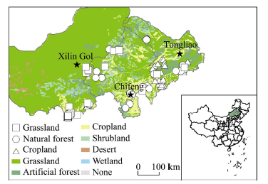
Soil organic carbon (SOC) stocks in terrestrial ecosystems vary considerably with land use types. Grassland, forest, and cropland coexist in the agro-pastoral ecotone of Inner Mongolia, China. Using SOC data compiled from literature and field investigations, this study compared SOC stocks and their vertical distributions among three types of ecosystems. The results indicate that grassland had the largest SOC stock, which was 1.5- and 1.8-folds more than stocks in forest and cropland, respectively. Relative to the stock in 0-100 cm depth, grassland held more than 40% of its SOC stock in the upper 20 cm soil layer; forest and cropland both held over 30% of their respective SOC stocks in the upper 20 cm soil layer. SOC stocks in grazed grasslands were remarkably promoted after ≥20 years of grazing exclusion. Conservational cultivation substantially increased the SOC stocks in cropland, especially in the 0-40 cm depth. Stand ages, tree species, and forest types did not have obvious impacts on forest SOC stocks in the study area likely due to the younger stand ages. Our study implies that soil carbon loss should be taken into account during the implementation of ecological projects, such as reclamation and afforestation, in the arid and semi-arid regions of China.
Key words: soil organic carbon; soil carbon profile; land use change; grazing; tillage; forest age
ZHAO Wei
,
HU Zhongmin
,
LI Shenggong
,
GUO Qun
,
YANG Hao
,
ZHANG Tonghui
. Impact of land use conversion on soil organic carbon stocks in an agro-pastoral ecotone of
Inner Mongolia[J]. Journal of Geographical Sciences, 2017
, 27(8)
: 999
-1010
.
DOI: 10.1007/s11442-017-1417-1
Figure 1 Geographical position of the study area and distribution of sampling sites. This figure was produced using ArcGIS 10.2 (Environmental Systems Research Institute). The background is the vegetation map according to the Editorial Committee of Vegetation Map of China (ECVMC, 2007). |
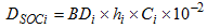

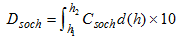
Figure 2 Box plot of soil carbon stocks (a) and their vertical distributions (b) for grassland, forest and cropland. Different letters indicate a significant difference in the total soil carbon stocks and soil carbon stocks of different depths between different land use types at the 0.05 level. NS signifies no significant difference. Bars denote standard error. Values in parentheses indicate the number of samples. Box plots display the median (solid line), mean (dotted line), interquartile range (upper and lower edge of box), 10-90 percentile (whiskers) and outliers (circles). |
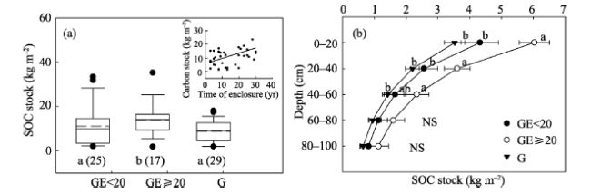
Figure 3 Comparison of SOC stocks (a) and their vertical distributions (b) between grazing-excluded (GE) (GE<20a, GE≥20a) and grazed (G) grasslands. The inset panel shows the relationship between SOC stock and the duration of GE. G, GE<20, and GE≥20 represent grazed grasslands, <20 years GE, and≥20 years GE grasslands, respectively. Different letters indicate a significant difference (p<0.05) in the total SOC stocks and SOC stocks at different depths among grassland types. Bars denote standard error. NS signifies no significant difference. Values in parentheses indicate the number of samples. |
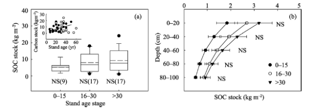
Figure 4 Effects of forest stand age on SOC stocks (a) and their vertical distribution (b). The inset panel in (a) shows the relationship between SOC stocks and forest stand age. Bars denote standard error. NS signifies no significant difference. Values in parentheses indicate the number of samples. |
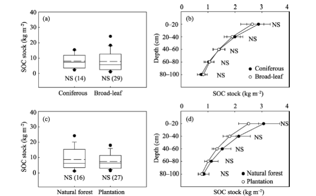
Figure 5 Comparisons of SOC stocks (a, c) and their vertical distribution (b, d) between coniferous and broadleaf forests (a, b) and between natural forests and plantation (c, d). Bars denote standard error. NS signifies no significant difference. Values in parentheses indicate the number of samples. |
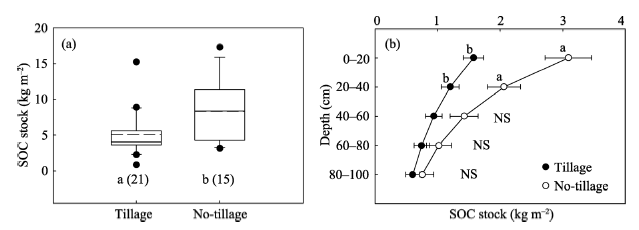
Figure 6 Comparisons of SOC stocks (a) and their vertical distributions (b) between conventional (tillage) and conservation cultivation (no-tillage) croplands. Different letters indicate a significant difference in the SOC stocks of different depths between tillage and no-tillage at the 0.05 level. Bars denote standard error. NS signifies no significant difference. Values in parentheses indicate the number of samples. |
The authors have declared that no competing interests exist.
| 1 |
|
| 2 |
|
| 3 |
|
| 4 |
|
| 5 |
|
| 6 |
|
| 7 |
|
| 8 |
|
| 9 |
Editorial Committee of Vegetation Map of China (ECVMC), 2007. Vegetation Map of the People’s Republic of China (1:1000000)
|
| 10 |
|
| 11 |
|
| 12 |
|
| 13 |
|
| 14 |
|
| 15 |
|
| 16 |
|
| 17 |
Intergovernmental Panel of Climate Change (IPCC), 2007. Fourth Assessment Report: Climate Change 2007 (AR4). IPCC, Geneva, Switzerland, 2007.
|
| 18 |
|
| 19 |
|
| 20 |
|
| 21 |
|
| 22 |
|
| 23 |
|
| 24 |
|
| 25 |
|
| 26 |
|
| 27 |
|
| 28 |
|
| 29 |
|
| 30 |
|
| 31 |
|
| 32 |
|
| 33 |
|
| 34 |
|
| 35 |
|
| 36 |
|
| 37 |
|
| 38 |
|
| 39 |
|
| 40 |
|
| 41 |
|
| 42 |
|
| 43 |
|
| 44 |
|
| 45 |
|
| 46 |
|
| 47 |
|
| 48 |
|
| 49 |
|
| 50 |
|
/
| 〈 |
|
〉 |