Orginal Article

Holocene environmental changes around Xiaohe Cemetery and its effects on human occupation, Xinjiang, China

  • ZHANG Yifei , 1, * ,
  • MO Duowen , 1 ,
  • HU Ke 2 ,
  • BAO Wenbo 3 ,
  • LI Wenying 4 ,
  • Idilisi Abuduresule 4 ,
  • Michael J. STOROZUM 5 ,
  • Tristram R. KIDDER 5
Expand
  • 1. Laboratory for Earth Surface Process, Ministry of Education, College of Urban and Environmental Sciences, Peking University, Beijing 100871, China
  • 2. Shaanxi Provincial Institute of Archaeology, Xi’an 710054, China
  • 3. College of Archaeology and Museology, Peking University, Beijing 100871, China
  • 4. Xinjiang Cultural Relics and Archaeology Institute, Urumqi 830000, China
  • 5. School of Anthropology, Washington University in St. Louis, C.B. 1114, St. Louis, MO 63130, USA

Author: Zhang Yifei (1988-), PhD Candidate, specialized in geomorphology and environmental change. E-mail:

*Corresponding author: Mo Duowen (1955-), Professor, E-mail:

Received date: 2016-09-14

  Accepted date: 2016-11-25

  Online published: 2017-06-10

Supported by

Major Program of National Social Science Foundation of China, No.11&ZD183

National Key Project of Scientific and Technical Supporting Program of China, No.2013BAK08B02

National Natural Science Foundation of China, No.41171006

Copyright

Journal of Geographical Sciences, All Rights Reserved

Abstract

The Xiaohe Cemetery archaeological site (Cal. 4-3.5 ka BP) is one of the most important Bronze Age sites in Xinjiang, China. Although the surrounding environment is an extremely arid desert now, abundant archaeological remains indicate that human occupation was common during certain periods in the Holocene. Field investigations and laboratory analyses of a sediment profile near the Xiaohe Cemetery indicate that while the regional environment was arid desert throughout the Holocene there were three episodes of lake formation near the site in the periods 4.8-3.5 ka BP, 2.6-2.1 ka BP and 1.2-0.9 ka BP. Geomorphic and hydrological investigations reveal that a lake or lakes formed in a low-lying area when water was derived initially from the Kongque River and then shunted into the Xiaohe River basin. Low amounts of active chemical elements in lacustrine sediment between 4.8-3.5 ka BP indicate abundant and continuous water volume in the lake; the content of active chemical elements increased between 2.6-2.1 ka BP but was still at a relatively low level, suggesting a declining amount of water and diminished inflow. Between 1.2-0.9 ka BP there was a very high content of active elements, suggesting decreased water volume and indicating that the lake was stagnate. In contrast, the general climate condition shows that there had a warm-humid stage at 8-6 ka BP, a cool-humid stage at 6-2.9 ka BP and a warm-dry stage at 2.9-0.9 ka BP in this region. The hydrological evolutions around Xiaohe Cemetery did not have one-to-one correspondence with climate changes. Regional comparison indicates that broad-scale climatic conditions played an important role through its influences on the water volume of the Tarim River and Kongque River. But, the formation of the lakes and their level were controlled by geomorphic conditions that influenced how much water volume could be shunted to Xiaohe River from Kongque River. Human occupation of the Xiaohe Cemetery and nearby regions during the Bronze Age and Han-Jin period (202 BC-420 AD) corresponded to the two earlier lake periods, while no human activities existed in the third lake period because of the decreased water volume.

Cite this article

ZHANG Yifei , MO Duowen , HU Ke , BAO Wenbo , LI Wenying , Idilisi Abuduresule , Michael J. STOROZUM , Tristram R. KIDDER . Holocene environmental changes around Xiaohe Cemetery and its effects on human occupation, Xinjiang, China[J]. Journal of Geographical Sciences, 2017 , 27(6) : 752 -768 . DOI: 10.1007/s11442-017-1404-6

1 Introduction

In recent years the close relationship between paleoenvironmental changes and ancient cultural evolution has been repeatedly demonstrated (Sandweiss et al., 1999; Mo et al., 2010; Berglund, 2003; Kuper and Kropelin, 2006; Guo et al., 2013; Li et al., 2014). With detailed case studies from different archaeological sites and ancient cultures in diverse geographic regions, scholars have recognized there are many ways that humans are affected by the environment. While climate changes have been widely accepted as an important influence on cultural evolution in many areas (Gupta et al., 2004; Piao et al., 2010; Chen et al., 2015), other environmental processes, such as changing fluvial regimes (Zong et al., 2007; Kidder et al., 2012; Li et al., 2014), or the rise and fall of lake levels (Nunez et al., 2002; Canellas-Bolta et al., 2013) are understood to have equally important effects. Similarly, vegetation changes (An et al., 2014; Li et al., 2015; Yue et al., 2015) or altered geomorphic conditions (Wu et al., 2014; Zhou et al., 2014) must be considered. An important challenge for paleoenvironmental researchers is to sort out the cause-and-effect relationships among and between the many possible factors that affect human social and cultural development. Thus, while climate change may be important, its effects may be mediated through other physical processes that must be understood in regards to how humans respond to the environment.
The Xiaohe Cemetery archaeological site (Figure 1, Cal. 4-3.5 ka BP; Li et al., 2013), has attracted considerable attention because its exceptionally preserved mummified human remains and abundant cultural relics (Xie et al., 2007; Li et al., 2011; Qiu et al., 2014; Yang et al., 2014; Yang et al., 2014; Mai et al., 2016). The Cemetery was extensively investigated by the Xinjiang Cultural Relics and Archaeology Institute, Urumchi, China (henceforth, XCAI) in 2002. The site is a human-made mound constructed on a natural dune and standing about 7.75 m tall. At least 167 boat-shaped coffins, deposited in five layers, were discovered in the cemetery. All coffins were made of populus wood and some were wrapped in cowhide and covered with mud. Mummified human remains inside the coffins were wearing felt caps, fur coats, leather boots, and fur cloak wrappings. Artifacts associated with mummies included straw baskets, some copper and jade ornaments, and feathers; large quantities of wood items, especially Ephedra and Tamarix twigs, were also found in the coffins. Grains of bread wheat (Triticum aestivum) and broomcorn millet (Panicum miliaceum) were found in straw baskets in most coffins (XCAI, 2004, 2007; Yang et al., 2014).
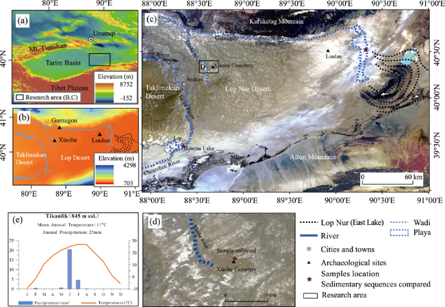
Figure 1 The location of Xiaohe Cemetery in Xinjiang, China

(a) Black rectangle marks the location of research area b and c. (b) The elevation of the research area based on DEM data (resolution of the Digital Elevation Model data is 90 m). (c) The geomorphic situation of the area based on satellite map (the map was created by merging bands 1, 2, and 3 of four 30 m-resolution Landsat-5 pictures). (d) Samples’ location and the landscape around Xiaohe Cemetery. (e) The modern monthly changes of temperature and precipitation, observed by the Tikanlik meteorological station (2013).

An environment suitable for cultivation of these crops clearly existed for the people who buried their dead at Xiaohe Cemetery. The inhabitants lived on a mixed diet of hunting and gathering supplemented by growing wheat and millet and herding cow and sheep. Today, the area around Xiaohe Cemetery is extremely dry and is in a barren desert; sand dunes, dry wadis and desiccated playas are common in the region. No human live here now (Wang et al., 2008) and the area is known as “dead land” in historical records and foreign adventurers’ writings (Bergman, 1939). Clearly, the environment that supported such a sophisticated culture has changed significantly over the past 4000 years.
Palynological analysis shows that reed (Phragmites sp.), Typha, lovegrass (Eragrostis) and Aster-type Asteraceae were present in the mud wrapping applied to the coffins (Li et al., 2013). These are the only paleoenvironmental data for the Xiaohe Cemetery, and they indicate that there was a well-watered oasis near the site at the time it was occupied. Our analysis focuses on understanding the evolution of this oasis and why it eventually dried up. In addition, we are interested in understanding how the evolution of the oasis affected human cultural occupation at Xiaohe and in the nearby region. We conducted a hydrological and geomorphic survey in research area and apply laboratory analyses of sediment sequences to understand the history of Holocene environmental changes and their influences on culture occupation in the area.

2 Study area

2.1 Environmental and geographical setting

The Xiaohe Cemetery is located in the Lop Nur Desert (Figure 1b), which is in the eastern part of the Tarim Basin, Xinjiang (Figures 1a-c). The Lop Nur Desert is the lowest area of the Tarim Basin and is very flat, with an elevation of 790-810 m asl (Figure 1b). The lower channels of the Tarim River and Kongque River flow along the western and northern margins of the Lop Nur Desert and end at Taitema Lake and Lop Nur (Figure 1c), respectively. These two rivers flow along the edges of an extensive alluvial fan located between the Kuruketag Mountains on the north and the Taklimakan Desert to the west, and Altun Mountains on the south (Figure 1c). Because of the low gradient of the fan and the significant amount of sediment carried by these rivers as they emerge from the mountains the channels of the Tarim and Kongque rivers have freely migrated across the fan and are interlaced in the area from Yuli to Su-Klein. Channel switching of the two rivers has been common through time (Wang, 1996; Fan et al., 2006; Xia et al., 2008; Han and Xie, 2010). The Xiaohe River (Small River) is a distributary of Kongque River that flows from northwest to southeast ending in the desert (Figure 1c). The paleochannel of the Xiaohe River is 5 km away from the west side of Xiaohe Cemetery (Figure 2b). Today, these rivers and lakes are drying up.
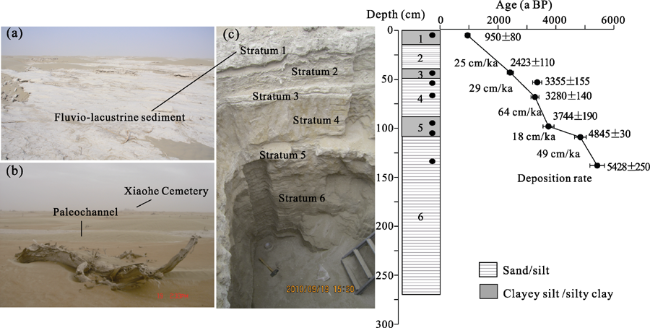
Figure 2 The environment around Xiaohe Cemetery (a and b) and the stratigraphy of the XH-N profile with ages (c)
The climate of the Lop Nur Desert belongs to a temperate continental type. Precipitation is about 20-30 mm per year and summer-winter temperature differences are considerable (Figure 1e). Meteorological records (1961-1990) at Lop Nur reveal that the average evaporation rises to 2902 mm per year and windy days occur one-third of the year (Luo et al., 2008). Plants mainly grow in the middle reaches of the Tarim River and along both sides of the Cheercheng River today. Existing vegetation is dominated by Populus euphratica and Tamarix chinensis. However, almost nothing grows within the Lop Nur Desert.

2.2 Archaeological background

No Neolithic archaeological sites have been found in the Lop Nur Desert. The Xiaohe Cemetery is one of the most important archaeological sites of Bronze Age in Xinjiang and also the earliest archaeological relics discovered to date within the Xiaohe River basin. After the Xiaohe Cemetery was abandoned, human vacated the Xiaohe River basin until the Han Dynasty. Archaeological sites, graves, artifacts and other relics dating to the Han and Jin dynasties (202 BC-420 AD) have been discovered within the Xiaohe River basin. An ancient city site radiocarbon dated to ca. 440-500 AD was found at about 6.3 km to the northwest of the Xiaohe Cemetery (Lv et al., 2010). Following this occupation, no human settlements existed until the modern era.
The Gumugou Cemetery (ca. 3.8 ka BP), situated 50 km to the north is contemporary with Xiaohe Cemetery (Figure 1b). In the Han and Jin Dynasty periods (202 BC-420 AD), Loulan City (Figure 1b) was one of the centers of trade and exchange in the area. Other major sites, such as Milan City site (Milan, Figure 1c) and Qieerqiduke City site (near the Charkhlik, Figure 1c) were abandoned at latest in the Tang Dynasty (618-907 AD) (Wang, 1998; Han and Xie, 2010).

3 Materials and methods

3.1 Sedimentary sequence and sampling

Fluvio-lacustrine sediments of wadi and playa are present around the site today (Figures 2a-b). In 2010 a 3-m deep trench (labeled XH-N, Figure 2c) was excavated into the playa bed ~800 m north of the Xiaohe Cemetery (Figure 1d). The profile (Figure 2c) was divided into six strata based on physical and visual characteristics of the sediment (Table 1). We collected 55 sediment samples at 5 cm interval and obtained 7 chronological samples (6 for OSL and 1 for radiocarbon dating) (Figure 2).
Table 1 Sedimentary sequence of the XH-N profile
Stratum No. Depth (cm) Sedimentary description
1 0-15 Fluvio-lacustrine sediment, light greyish clayey silt with plant rootlets
2 15-40 Greyish fine sand with some silt layers, laminar structure
3 40-50 Fluvio-lacustrine sediment, light greyish clayey silt
4 50-90 Yellowish grey fine sand mixed with coarse sand, laminated and yellow rust spots
5 90-110 Fluvio-lacustrine sediment, light greyish silty clay with snail shells in the bottom
6 110-275 Brownish fine sand and medium sand, laminar structure

3.2 Laboratorial analysis of the samples

Chronological research was conducted in the Technology Archaeology Laboratory of the School of Archaeology and Museology, Peking University. We chose 7-11 μm-sized quartz grains as the OSL material to ensure the luminescence signal was exposed before deposition. The radiocarbon date was obtained from snail shell and the result was calibrated using OxCal v3.10 (Ramsey, 2005). All chronological data were unified to be relative to AD1950 (referred to as “a BP”).
Fifty-five samples from the XH-N were analyzed for grain size and geochemical elements in the Laboratory for Land Surface Processes, Peking University and the Laboratory for the Orogenic Belt and Tectonic Movement, Peking University, respectively. Grain size was obtained by the Laser Particle Analyzer (Mastersizer 2000 manufactured by Malvern Company). Geochemical elements were investigated by using X-ray fluorescence spectroscope and the analytical results are reported as oxide compound form and percentage (10% is equivalent to 100 mg/g). The deviation based on repeat sample analysis was between 3% and 5%.

4 Results

4.1 Stratigraphy and chronological dating

Seven chronological samples (Table 2) were taken at 10-15 cm, 45-50 cm, 55-60 cm, 70-75 cm, 95-100 cm, 100-105 cm and 135-140 cm below the ground surface. The ages are in stratigraphic order except for sample XHB-3 (Figure 2 and Table 2). The data indicate an average sedimentation rate of 37.4 cm/ka for this profile (Figure 2); strata 2, 4 and 6, which are mainly composed of silt and sand, have a faster deposition rate than the fluvio-lacustrine strata 1, 3 and 5. The two data from stratum 4 are reversed, but the age differences are within the error ranges. This inversion may be because stratum 4 has the fastest deposition rate of the whole profile (64 cm/ka, Figure 3), resulting in incomplete exposure of quartz grains.
Table 2 Detailed information of every chronological sample
Sample No. Stratum No. Depth (cm) Dating method Dating material Age
XHB-1 1 10-15 OSL Silty clay 950±80 a BP
XHB-2 3 45-50 OSL Clayey silt 2423±110 a BP
XHB-3 4 55-60 OSL Silt and sand 3355±155 a BP
XHB-4 4 70-75 OSL Silt and sand 3280±140 a BP
XHB-5 5 95-100 OSL Silty clay 3744±190 a BP
XHB-6 5 105-110 14C, AMS Snail shell 4845±30 Cal. a BP
XHB-7 6 135-140 OSL Silt and sand 5428±250 a BP
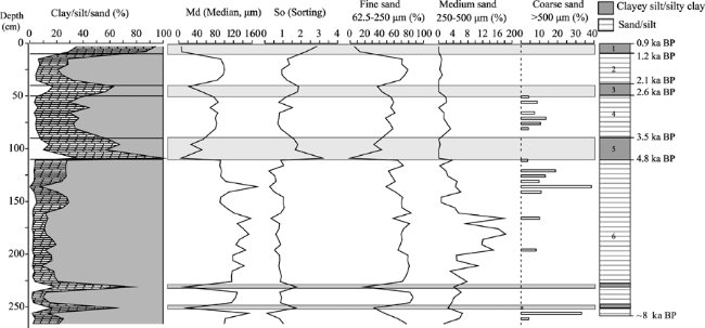
Figure 3 Variations of grain size parameters with the depth of the XH-N profile (Gray shading indicates the fine-grained strata)
With the deposition rate in different stratum (Figure 2), we defined the age range of each stratum of the XH-N profile. The bottom of the stratum 6 presumably reaches to ~8 ka BP of the late early-Holocene or early middle-Holocene. So, the XH-N profile involves the Holocene sediment between 0.9-8 ka BP and the age intervals of each stratum are: (1): 0.9-1.2 ka BP; (2): 1.2-2.1 ka BP; (3): 2.1-2.6 ka BP; (4): 2.6-3.5 ka BP; (5): 3.5-4.8 ka BP; and (6): 4.8-8 ka BP. The Xiaohe Culture period corresponds to stratum 5.

4.2 Grain size results

Grain size is generally interpreted as a proxy for past changes in transport and deposition dynamic (Zhang et al., 2010; An et al., 2012). We classified grain size using the Wentworth scale; sand composition was divided into fine sand (62.5-250 μm), medium sand (250-500 μm) and coarse sand (500-2000 μm). Md (median size) is the 50% value of the accumulation probability curve; the sorting index (So) is defined by the formula (ф8416)/4+ (ф955)/6.6 (Folk, 1957; ф84 is the 84% accumulated value of the accumulation probability curves). Five representative types of accumulation probability curves of grain size (Figure 4) in different strata indicate the sedimentary process and grain source.
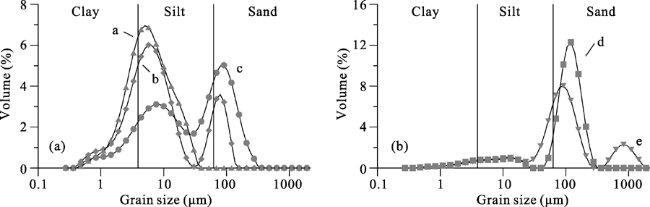
Figure 4 Five representative types of the frequency curves of grain size distribution in different strata
The results (Figure 3) of grain size analysis verify the characteristic of sedimentary changes we observed from the profile and that are indicated by the deposition rate changes: strata 1, 3 and 5 (and two samples at the bottom of stratum 6) are mainly composed of silt and clay (40%-60% and 10%-35%, respectively); strata 2, 4 and 6 are made up of relatively coarse grains of sand and silt (60%-80% and 10%-20%, respectively). The sand found in strata 2, 4 and 6 are mostly fine; medium sand comprises only 15%-20% in the middle of stratum 6 and coarse sand makes up only 10%-35% of strata 4 and 6.
Frequency curve types a, b and c (Figure 4) are mainly present in strata 1, 3 and 5; two peaks are observed for types a and c, indicating two different sedimentary processes existed simultaneously. Frequency curve Type d (Figure 4) is present in strata 2, 4 and 6 and there is only one peak of the curve, indicating a single sedimentary process existed at that time. These differences can also be seen in the sorting index: the sorting value of strata 2, 4 and 6 is lower than in strata 1, 3 and 5 (So, Figure 3), revealing a relative well sorted single sedimentary process in these strata. The frequency curve of a few samples in strata 4 and 6 is Type e (Figure 4), which corresponds with the high values of coarse sand content in Figure 4. Type c is also present in the middle of stratum 2, indicating that there is some variability in the sedimentary processes that were occurring at this time.

4.3 Geochemical elements results

We tested for ten major geochemical elements (Figure 5). SiO2 accounts for more than 60% of the total volume, on average, while MnO is the lowest, with no more than 0.1% of the total volume. The transport and gathering processes of the geochemical elements in the sediments are complex and the distribution of geochemical elements in different strata demonstrates various environmental characteristics and climate information (Zhong et al., 2005; Luo et al., 2008; Jia et al., 2012).
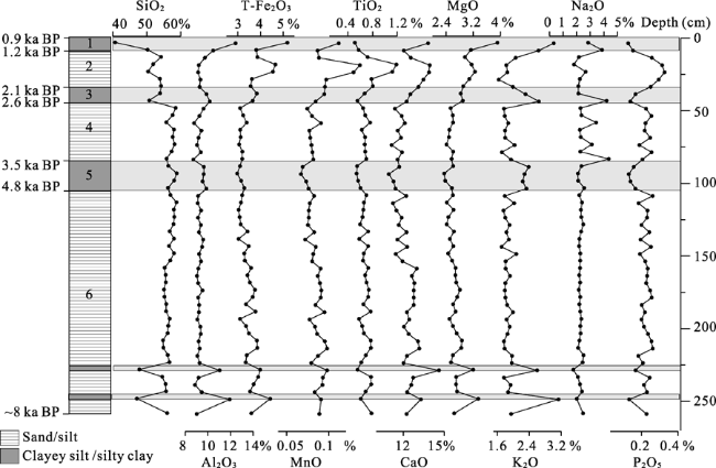
Figure 5 Variations of ten major geochemical elements with the depth of the XH-N profile (Gray shading indicates the fine-grained strata)
Most chemical elements have a close correlation with the changes in grain size indexes. Specifically, SiO2, Al2O3, K2O and P2O5 are strongly correlated (Figure 5). Al2O3 and K2O have an obvious positive correlation with the fine-grain content and SiO2 and P2O5 have a negative correlation in these strata. TiO2 and Na2O have a narrow range (Figure 5), but, TiO2 has an obviously higher percentage composition in the middle of stratum 2, as do T-Fe2O3, MnO, CaO and P2O5. The percentage composition curve of Na2O has a high value in stratum 1, and at the bottom of strata 3 and 4. The content changes of T-Fe2O3, MnO, CaO and MgO, which are generally higher in the upper ~70 cm and lower ~100 cm of the profile, correlate with episodes of fine-grain deposition. However, this correlation does not hold in the middle of the profile where these four chemical elements do not show a clear relationship with the fine-grain deposits of stratum 5.

5 Discussion

5.1 Sedimentary facies and environmental interpretation

The deposition history around Xiaohe Cemetery as revealed by analysis of the XH-N profile varies between two facies: fine-grained and coarse-grained. We analyzed these changes from the bottom of the profile to the top.
Stratum 6 (~8-4.8 ka BP): Sediments in this stratum are primarily composed of sand (~ 70%) with low amounts of clay and silt (Figure 3). the main grain size frequency curve is Type d (Figure 4). The curve is well peaked and the peak value ranges between ~100 and 125 μm (very fine sand); this curve is similar to the grain size distribution of the sediments found in modern Taklimakan Desert sand (Yin et al., 2009) and in the fluvial sand of Tarim River (Feng et al., 1999). Stratum 6 has the highest Md value (Figure 3, 130-140 μm), the lowest clay and silt content (Figure 3, average 20%), and the best sorting (Figure 3, So < 1) of the profile; the sorting index here is close to the characteristic of aeolian sand. The high content of SiO2 and relative lower percentage of T-Fe2O3 and Al2O3 indicate a weak weathering intensity, typical of an aeolian sand environment. Coarse sand was being transported by high-energy processes as indicated by the Type e curve (Figure 4), with a peak value ranging between ~750 and 1000 μm. In the Lop Nur, coarse sand in the sedimentary sequence is considered an indication of strong sand storms (Ma et al., 2008). The high percentage composition of coarse sand (Figure 3) at 120-140 cm (~5.2-5.8 ka BP) and 255-265 cm (approx. 8 ka BP), corresponds to periods of Holocene cold climate events (Bond et al., 1999). There are two stratigraphically brief episodes of fine-grain deposition in stratum 6, indicating periods of lesser aridity. However, the geochemical signatures of these events suggest that if there was standing water it was subject to high evaporation and would have been shallow and stagnant.
Stratum 5 (4.8-3.5 ka BP): Sediments of the stratum are composed of silt and clay (60%-80%) with relatively little sand (Figure 3). The grain size frequency curves are Types a and b (two peaks, Figure 4). The value of main peak ranges between 5 and 8 μm (fine silt), which we interpret as lentic sediments associated with a lake or standing water. The secondary peak of the frequency curves range between 90 and 100 μm and we interpret this peak to show that the lake environment was surrounded by desert at that time. The high percentage composition of Al2O3 is also attributed to the lake environment because the stable chemical element Al accumulates from strong weathering intensity (Zhang et al., 2008). Normally, lake environments in arid deserts are characterized by sediments that develop as carbonate and sulfate minerals precipitate out of solution as a result of evaporation. Ca, Mg and Na are very active chemical elements which are easily transported or leached by water flow (Sun et al., 2010). The gathering of active elements in lacustrine sediments indicates high concentration of minerals, and the lake would be shrinking with decreased water and/or enhanced evaporation intensity, high content of Na would be expected if the lake was nearly stagnant and endorheic. In stratum 5, however, low percentages of CaO, MgO and Na2O suggest the abundant water in the lake with weak evaporation capacity at this time.
Stratum 4 (3.5-2.6 ka BP): Sediments of this stratum are mainly composed of sand (around 65%) and have low clay and silt content (Figure 3). The sedimentary characteristics of this stratum are similar to those found in stratum 6. The main grain size frequency curve is Type d (Figure 4), indicating that an aeolian sand environment was dominant at this time. The high percentage composition of SiO2 and the low content of Al2O3 and T-Fe2O3 confirm this interpretation. The high content of coarse sand (Figure 3) that appears at 75-85 cm (~3-3.5 ka BP), along with short-lived but relatively large changes in elements such as AL2O3, MnO, K2O and Na2O, suggest a brief but intense cool-dry episode at this time (Bond et al., 1999).
Stratum 3 (2.6-2.1 ka BP): Sediments of the stratum are mainly composed of silt and clay (60%) with a low content of sand (Figure 3). The grain size frequency curves are Types b and c (Figure 4). The fine-grained sediments and relatively high percentage composition of Al2O3 and T-Fe2O3 indicates that a lake emerged at this time, similar to what was seen in stratum 5. However, increasing percentage composition of CaO and MgO indicates the decreased water and relatively enhanced evaporation capacity. A high value of Na2O content presents in the bottom of the stratum and a low one after that shows that the lake was relative stagnant compared to the lake that emerged in stratum 5.
Stratum 2 (2.1-1.2 ka BP): Sediments of this stratum are predominantly sand (around 65%) with modest clay and silt content (Figure 3). The primary grain size frequency curve is Type d (Figure 4) but samples in the middle of stratum 2 are Type c. The sedimentary characteristics are largely similar to strata 6 and 4 but the geochemical data suggest a more humid situation than in earlier times. The peak value of P2O5 indicates well vegetated conditions because the elevated concentration of P is associated with the deposition of organic materials (Costa et al., 2013). The high percentage composition of T-Fe2O3 and CaO reveal a lakeside or fluvial environment with high evaporation intensity. Considerable environmental variation is suggested by the varying signals suggesting both more humid conditions but also the presence of aeolian sand encroaching on the profile area around 1.5 ka BP.
Stratum 1 (1.2-0.9 ka BP): Sediments of this stratum are dominated by silt and clay (90%) with little sand (Figure 3). The grain size frequency curves are Types a and b (Figure 4). The fine-grained sediments and the relative high quantities of Al2O3 and T-Fe2O3 indicate that there was a standing lake, somewhat similar to what we saw in strata 5 and 3. In stratum 1, however, the very high percentage composition of CaO and MgO indicates the reduced water volume and strong evaporation capacity. The high value of Na2O shows that this lake was shallow and stagnant compared to the lakes that developed in strata 5 and 3.

5.2 Regional differences and affect factors of environmental changes

Interpretation of the grain size and chemical element data indicates that the environment around Xiaohe Cemetery was mainly a desert throughout the Holocene but that it was punctuated with three episodes of lake/oasis formation ca. 4.8-3.5 ka BP, 2.6-2.1 ka BP and 1.2-0.9 ka BP (Figure 6g). The lake that emerged at ca. 4.8-3.5 ka BP had relative abundant and continuous water, and water inflow exceeded evaporation in a long time; the lake that formed ca. 2.6-2.1 ka BP had a relative higher evaporation capacity and reduced more water volume than the previous one; and the one that emerged ca. 1.2-0.9 ka BP, was very shallow and stagnant with strong evaporation capacity.
Figure 6 Comparisons of climate conditions and hydrological conditions of the indexes of the XH-N profile to the other researches, two periods of human occupation observed as black rectangles in bottom.

(a. δ18O from Guliya ice core (Thompson et al., 1999); b. 65° summer insolation (Berger and Loutre, 1991); c. Average moisture index in ACA (Chen et al., 2008); e. A/C ratio of Taitema Lake (Zhong et al., 2005); f: Clay content of Lop Nur (Ma et al., 2008); d and g: This research)

5.2.1 Climate background
Climate in the research area is dominated today by westerlies (Chen et al., 2008; Zhao et al., 2015). The δ18O record from Guliya ice core (Figure 6a) indicates rising temperatures beginning ca. 8 ka BP, which corresponds to increasing solar insolation (Figure 6b). The Arid Central Asia (ACA) moisture index (Chen et al., 2008) shows a rising trend from 8 ka BP (Figure 6c). The central part of the Bosten lake basin was cover by meters of aeolian sand then a layer of dark peat formed around 8.2 ka BP (Mischke and Wunnemann, 2006); after 8 ka BP, a stable lake formed in the basin (Huang et al., 2009). The low value of Si/Fe ratio in our XH-N profile also reveals strong weathering intensity in the Early Holocene (Figure 6d). These indicators suggest that climatic conditions in eastern Xinjiang were relatively warm and humid in the early to middle Holocene.
Diminishing δ18O values of Guliya ice core (Figure 6a), and decreased solar insolation (Figure 6b), suggest a cooler climate emerged following ~6.8 ka BP. The ACA moisture index (Figure 6c) declined slightly but was still above average. At Balikun Lake, the climate was generally cool and humid during this period, as indicated by lower carbonate content, higher organic content and relative high A/C ratio (Artemisia and Chenopodiaceae, An et al., 2012). From 5.5-4 ka BP, the A/C ratio from Lake Sayram suggests that the humidity was generally high (Jiang et al., 2013). The decreasing Si/Fe ratio in the XH-N profile indicates a lower weathering intensity (Figure 6d). The climate was relatively cool and humid in this period.
After 2.8 kaBP, the decreasing ACA moisture index (Figure 6c) indicates that climate conditions were trending towards increasing aridity. Palynological research indicates that the percentage composition of drought-resistant plants increases (Yao et al., 2015). The Guliya record shows a slow warming trend (Figure 6a) despite the fact that solar insolation was still declining (Figure 6b). The Bosten Lake record indicates rising temperatures, which are indicated by stronger evaporation as measured by an increase in carbonate content (Huang et al., 2009). The Si/Fe ratio in the XH-N profile shows that weathering intensity was growing (Figure 6d). The rapid increase in the Si/Fe ratio demonstrates the high evaporation of the lake environment seen in stratum 1. The climate was warm and dry through this period.
In light of the broad climate trends discussed here it is evident that the three episodes of lake formation around Xiaohe Cemetery did not occur when there were clear signals of humid climate conditions in the region. This is especially notable for the lakes that formed ca. 2.6-2.1 ka BP and 1.2-0.9 ka BP; these lakes developed at a time of regionally increasingly arid climatic circumstances. The desiccation of the lakes is also negatively correlated with regional climatic changes.
5.2.2 Regional comparison
From the above discussion it is evident that lake evolution in the Xiaohe Cemetery area was not directly driven by the regional climate. Instead, we argue that the Xiaohe Cemetery environment was affected more by local geomorphic circumstances than acted on by larger climate processes. The Xiaohe River is situated on the alluvial fan formed by the Tarim and Kongque rivers. The low gradient of this fan and the relatively coarse composition of the fan sediments encourage the formation of multiple braided channels with high rates of anastomization (Makasake, 2001). Water flow in the fan was evidently alternating back and forth as channels filled or cut into the fan surface. The proclivity for channel switching by the Tarim and Kongque rivers had been discussed before (Wang, 1996; Fan et al., 2006; Xia et al., 2008; Han and Xie, 2010). The river networks on the alluvial fan are sensitive to geomorphological changes and erosion, which could have substantially changed water allocation and distribution in the area.
The influence of local geomorphology and especially channel switching on the alluvial fan can be seen by comparing the Xiaohe Basin with Taitema Lake, which gets flow from the Tarim River, and Lop Nur, which receives its inflow from the Kongque River (Figures 6e and 6f). In the Early Holocene, Taitema Lake (Figure 6e) had good hydrological conditions and the environment was well vegetated, as indicated by the rising A/C ratio in early-mid Holocene, which reached its peak value ca. 7 to 6 ka BP. The Lop Nur had an increased clay content from 8 ka BP which then slowly dropped down after 7 ka BP (Figure 6f); the relative low percentage composition of clay indicates the hydrological conditions of Lop Nur were not as good as those in Taitema Lake. These data suggest the water from Tarim-Kongque River mainly flowed through the Tarim River into Taitema Lake; only a small quantity of water flowed into the Lop Nur, which is the downstream basin of the Kongque River. The environment around Xiaohe Cemetery was desert at this time because water barely flowed into Xiaohe River basin.
A substantial oasis evolved in the Xiaohe Cemetery area at ca. 4.8-3.5 ka BP. This oasis could only develop if abundant water flowed into Xiaohe River basin and could only happen if the Kongque River carried substantial flow. At this same time, decreased A/C ratio (Figure 6e) and low percentage composition of clay (Figure 6f) reveals that hydrological conditions in Lop Nur and Taitema Lake were relatively poor. High A/C ratio in Taitema Lake ca. 4-3 ka BP indicates some amount of water flowed into the downstream basin of the Tarim River, but most of the water flow was in the Kongque River basin where a channel shift allowed it to be shunted into the Xiaohe River, thus allowing for the formation of lakes and an oasis. A gradual channel switch, perhaps caused by sediment accumulation near the head of the Xiaohe River, may be responsible for the desiccation of the lakes/oasis around Xiaohe Cemetery and thus the decline of Xiaohe culture. The rise in A/C ratio of Taitema Lake just prior to 3.5 ka BP corresponds with a decline in clay percentages in Lop Nur and indicates an increasing diversion of water flow from the Kongque to the Tarim River.
After ca. 3 ka BP, lakes formed around Xiaohe Cemetery at 2.6-2.1 ka BP and 1.2-0.9 ka BP but the water was relative shallow, with strong evaporation intensity; these poor hydrological conditions are especially seen in the lake that emerged around 1 ka BP. Clearly there was sufficient flow in the Xiaohe River to sustain lakes in these two periods. At the same time, desert vegetation was common around Taitema Lake, as indicated by an A/C ratio < 0.5 following 2.5 ka BP. In contrast, at Lop Nur, the percentage composition of clay increases considerably (Figure 6f) and snails and phytoliths were found in sediment layers dated to this time, indicating that this was a period of very good hydrological conditions (Ma et al., 2008). The <Shui Jing Zhu> (Li, ~400AD) records that the Lop Nur was a “very vast lake with a great amount of water” and noted that “the water quantity was big enough that the lake level didn’t fall even when seasons shift”. These data indicated that water mainly flowed in the Kongque River and that the Tarim River was relative dry or underfit. Despite the flow in the Kongque River, however, water was not regularly diverted into the Xiaohe, possibly because of siltation and gradient shifts.
Even though they were within the same watershed and were being affected by similar climatic circumstances through time, the hydrological evolution of the Xiaohe River Basin, Lop Nur, and Taitema Lake varied considerably. Clearly, climate was not the direct influence on the hydrological evolution in the research area. Modern precipitation in the research area is only 20-30 mm/yr but even increased moisture availability caused by the Holocene climatic optimum was not enough to trigger the change from desert to lake around Xiaohe Cemetery. Instead, river water in the Kongque and Tarim rivers was influenced by glacial melting, which was affected by climate change. However, the flow of water into the Xiaohe Basin was the direct result of channel switching upstream. When the Kongque was the primary drainage system water was shunted into the Kongque River but when the Tarim River captured the main flow the Kongque River and the Xiaohe River ran dry. In the very late Holocene when the Kongque had become the principal drainage, the Xiaohe did not reactive because of changes to the local geomorphic situation.

5.3 Environmental changes and human occupation

In an arid desert with a fragile ecosystem the presence or absence of surface water available for human use was a primary influence on the settlement pattern through time. In times when there was standing surface water we see significant cultural development around Xiaohe Cemetery. This is especially notable during the Xiaohe and Loulan (late Western Han) periods, when cultural developments were most notable and correspond with the formation of lake oases.
The lake/oasis at Xiaohe Cemetery first formed 4.8-3.5 ka BP; the lake supplied enough fresh water to sustain the Xiaohe culture’s rise and development. A cool-humid climate also benefited the maintenance of the oasis. Human habitation expanded around 4 ka BP and people were able to practice agricultural activities in the flat plain among the rivers and lakes of the alluvial fan and to build the Xiaohe Cemetery on the dunes near the river. This situation lasted for about 500 years. Chronological and sedimentary evidence shows that lacustrine sediments were no longer being deposited after 3.5 ka BP. The desiccation of the lake and the reduction of the surface water resources correspond to the decline of the Xiaohe culture and the abandonment of the area. An arid environment existed between ca. 3.5-2.6 ka BP and standing surface water was minimal or absent; no human sites have been discovered in the downstream section of the Kongque River at this time (XCAI, 2008).
A lake re-emerged in the study area at 2.6-2.1 ka BP and some surface water for human use was still available for a short time up to ca. 1.5 ka BP. The development of this lake corresponds with the expansion of the Silk Road in Han times. Though the climatic condition was warm and dry, enough water inflow to Xiaohe River maintained the human activities here. After 2.1 ka BP, most of the water in the Kongque River gradually flowed to Lop Nur. Despite these environmental challenges, extensive human activities are documented around Xiaohe Cemetery and a prosperous culture developed around the nearby Loulan ancient city.
A shallow, stagnant lake was present between 1.2-0.9 ka BP. This lake was not a suitable environment for human use. Unsurprisingly, archaeological remains are absent at this time.

6 Conclusions

Analysis of the sediments in the XH-N profile reflects environmental changes around Xiaohe Cemetery over the period 8.2-0.9 ka BP: lakes formed as a result of steady fluvial input at 4.8-3.5 ka BP, 2.6-2.1 ka BP and 1.2-0.9 ka BP while a relative dry environment with weak fluvial activity predominated at other times. Geochemical analysis further demonstrates the environmental changes and indicates that the lake in the period 4.8-3.5 ka BP and 2.6-2.1 ka BP had better hydrological condition and the lake of 1.2-0.9 ka BP was shallow and stagnant.
The formation and transition of the hydrological environment in the research area was not solely affected by climate conditions. The formation of a lake and its associated environment depended on a continuous and abundant water supply, which was derived initially from the Kongque River and then shunted into the Xiaohe River basin. Climate change obviously controlled moisture availability at the broader scale, but suitable geomorphic and hydrological conditions dictated if water could flow into the Xiaohe River basin.
Abundant evidence indicates that the presence or absence of an oasis and available surface water had direct influence on the rise and development of culture during the Xiaohe and Han periods in the research area. These results suggest that even in extreme environments, climate change is not the sole driver of human occupation and land use. Archaeological and paleoenvironmental research must consider a wide array of factors when exploring the rise and fall of human cultures.

The authors have declared that no competing interests exist.

[1]
An Chengbang, Li Hu, Dong Weimiaoet al., 2014. How prehistoric humans use plant resources to adapt to environmental change: A case study in the western Chinese Loess Plateau during Qijia Period.The Holocene, 24(4): 512-517.Fossilized charcoals can document how prehistoric humans used wood resources. Here, we present a quantitative result of charcoal fossil records, compiled with archaeobotanical data of Qijia Culture (4.3-3.8 cal. kyr BP) in the western Chinese Loess Plateau, to study how prehistoric people used plant resources and adapted to their environment. The charcoal records showed that Quercus, Ulmus, Pyrus, Acer, Picea, Prunus, and Bambusoideae were abundant during the Qijia Period, implying a warmer and wetter environment at that time. It also clearly showed that Qijia people had a strong preference to select woods in their daily life. Quercus was the most favorable wood, and thus, it was found in all samples. Many fruit trees planted in the Chinese Loess Plateau today were found in charcoal records. These fruit trees were, during the Qijia Period, at least in the process of being domesticated. Qijia people expanded the scope of using plant resources, and many new crops appeared during that time. These results provide a new insight into economic management and human adaption strategies in the Neolithic Age.

DOI

[2]
An Chengbang, Lu Yanbing, Zhao Jiajuet al., 2012. A high-resolution record of Holocene environmental and climatic changes from Lake Balikun (Xinjiang, China): Implications for central Asia.Holocene, 22(1): 43-52.Our country land all sorts of different utilization and related planning for different environmental factors and these factors together constitute the ecological system are far-reaching,environment evaluation for our designers better land planning guidance,to prevent various adverse situations is also very important.This paper mainly studies our country land use planning various evaluation system based on the theory,and the combination of these different theoretical foundation to put forward our country land use planning may affect the evaluation of the different working procedures,the main purpose of this is to establish a suitable index system,so as to better our country land use and planning for the environment puts forward related suggestions and make suitable countermeasures.

DOI

[3]
Berger A, Loutre M, 1991. Insolation values for the climate of the last 10 million years. Quaternary Science Reviews, 10(4): 297-317.New values for the astronomical parameters of the Earth's orbit and rotation (eccentricity, obliquity and precession) are proposed for paleoclimatic research related to the Late Miocene, the Pliocene and the Quaternary. They have been obtained from a numerical solution of the Lagrangian system of the planetary point masses and from an analytical solution of the Poisson equations of the Earth-Moon system. The analytical expansion developed in this paper allows the direct determination of the main frequencies with their phase and amplitude. Numerical and analytical comparisons with the former astronomical solution BER78 are performed so that the accuracy and the interval of time over which the new solution is valid can be estimated. The corresponding insolation values have also been computed and compared to the former ones. This analysis leads to the conclusion that the new values are expected to be reliable over the last 5 Ma in the time domain and at least over the last 10 Ma in the frequency domain.

DOI

[4]
Berglund R E, 2003. Human impact and climate changes: Synchronous events and a causal link?Quaternary International, 105(1): 7-12.Interaction between cultural development and the natural environment is generally accepted. Holocene climate change is described as one of the main environmental factors behind a step-wise development of the cultural landscape in Northwest Europe. Seven periods of human impact changes—5900, 5500, 4500, 3800, 3000–2800, 1500 and 1100 cal. BP—are defined and compared with reconstructed climatic scenarios, based on insolation, glacier activity, lake and sea levels, bog growth, tree line, and tree growth. There is a positive correlation between human impact/land-use and climate change, although precise correlations are difficult because of weaknesses in the chronology. Future studies of annually laminated (varved) lake sediments and wiggle-matched radiocarbon sequences are emphasized, as well as a combination of palaeoecology and archaeology. It is hypothesized that agrarian society and the landscape developed step-wise, dependent on the interaction between the technological/social complex and the ecological capacity of a region, highly influenced by climate.

DOI

[5]
Bergman F, 1939. Archaeological Researches in Sinkiang-Especially the Lop-Nor Region. The Sino-Swedish Expendition, 7. Stockholm: Bokforlags Aktiebolaget Thule.

[6]
Bond G, Showers W, Cheseby Met al., 1997. A pervasive millennial-scale cycle in North Atlantic Holocene and glacial climates.Science, 278: 1257-1266.Evidence from North Atlantic deep sea cores reveals that abrupt shifts punctuated what is conventionally thought to have been a relatively stable Holocene climate. During each of these episodes, cool, ice-bearing waters from north of Iceland were advected as far south as the latitude of Britain. At about the same times, the atmospheric circulation above Greenland changed abruptly. Pacings of the Holocene events and of abrupt climate shifts during the last glaciation are statistically the same; together, they make up a series of climate shifts with a cyclicity close to 1470 卤 500 years. The Holocene events, therefore, appear to be the most recent manifestation of a pervasive millennial-scale climate cycle operating independently of the glacial-interglacial climate state. Amplification of the cycle during the last glaciation may have been linked to the North Atlantic's thermohaline circulation.

DOI

[7]
Canellas-Bolta N, Rull V, Saez Aet al., 2013. Vegetation changes and human settlement of Easter Island during the last millennia: A multiproxy study of the Lake Raraku sediments.Quaternary Science Reviews, 72: 36-48.ABSTRACT Root-knot nematodes (RKNs) induce inside the vascular cylinder the giant cells (GCs) embedded in the galls. The distinctive gene repression in early-developing GCs could be facilitated by small RNAs (sRNA) such as miRNAs, and/or epigenetic mechanisms mediated by 24nt-sRNAs, rasiRNAs and 21-22nt-sRNAs. Therefore, the sRNA-population together with the role of the miR390/TAS3/ARFs module were studied during early gall/GC formation. Three sRNA libraries from 3-d-post-inoculation (dpi) galls induced by Meloidogyne javanica in Arabidopsis and three from uninfected root segments were sequenced following Illumina-Solexa technology. pMIR390a::GUS and pTAS3::GUS lines were assayed for nematode-dependent promoter activation. A sensor line indicative of TAS3-derived tasiRNAs binding to the ARF3 sequence (pARF3:ARF3-GUS) together with a tasiRNA-resistant ARF3 line (pARF3:ARF3m-GUS) were used for functional analysis. The sRNA population showed significant differences between galls and controls, with high validation rate and correspondence with their target expression: 21-nt sRNAs corresponding mainly to miRNAs were downregulated, whilst 24-nt-sRNAs from the rasiRNA family were mostly upregulated in galls. The promoters of MIR390a and TAS3, active in galls, and the pARF3:ARF3-GUS line, indicated a role of TAS3-derived-tasiRNAs in galls. The regulatory module miR390/TAS3 is necessary for proper gall formation possibly through auxin-responsive factors, and the abundance of 24-nt sRNAs (mostly rasiRNAs) constitutes a gall hallmark.

DOI

[8]
Chen Fahu, Dong Guanghui, Zhang Dongjuet al., 2015. Agriculture facilitated permanent human occupation of the Tibetan Plateau after 3600 BP.Science, 347(6219): 248-250.

DOI

[9]
Chen Fahu, Yu Zicheng, Yang Meilinet al., 2008. Holocene moisture evolution in arid central Asia and its out-of-phase relationship with Asian monsoon history.Quaternary Science Reviews, 27(3/4): 351-364.We synthesize palaeoclimate records from the mid-latitude arid Asian region dominated today by the Westerlies (“arid central Asia” (ACA)) to evaluate spatial and temporal patterns of moisture changes during the Holocene. Sediment records from 11 lakes with reliable chronologies and robust proxies were selected to reconstruct moisture histories based on a five-class ordinal wetness index with assigned scores from the driest to wettest periods at individual sites for 200-year time slices. The proxies used in these records include pollen and diatom assemblages, sediment lithology, lake levels, and geochemistry (mainly isotope) data. The results of our synthesis show that ACA as a whole experienced synchronous and coherent moisture changes during the Holocene, namely a dry early Holocene, a wetter (less dry) early to mid-Holocene, and a moderately wet late Holocene. During the early Holocene most of the lakes experienced very low water levels and even dried out before ca 802ka (102ka=100002cal02a02BP). Hence the effective-moisture history in ACA is out-of-phase with that in monsoonal Asia as documented by numerous palaeoclimate records. In monsoonal Asia, a strong summer monsoon and humid climate characterized the early Holocene, and a weakened summer monsoon and drier climate prevailed during the late Holocene, which were mainly controlled by changes in low-latitude summer insolation. In contrast, we propose that the pattern of Holocene effective-moisture evolution in the westerly dominated ACA was mainly determined by North Atlantic sea-surface temperatures (SSTs) and high-latitude air temperatures that affect the availability, amount and transport of water vapor. Also, topography of the Tibetan Plateau and adjacent Asian highlands could have contributed to the intensification of dry climate in ACA during the early Holocene, as a result of strengthening the subsidence of dry air masses, associated with stronger uplift motion on the plateau by intense heating under a stronger summer insolation. Summer insolation might have played a key role in directly controlling moisture conditions in ACA but only after the northern hemisphere ice-sheets had disappeared in the mid- and late Holocene.

DOI

[10]
Chen Jing’an, Wan Guojiang, Zhang Fenget al., 2004. Environmental records of lacustrine sediments in different time scales: Sediment grain size as an example.Science China B, 33(6): 563-568Sediment grain size is a conventional proxy of climatic changes. Larger sediment grain size is often interpreted to indicate dry climate during lower lake level while smaller sediment grain size implies wet climate during higher lake level. Through detailed study on sediment grain sizes in Lake Erhai and Lake Chenghai, this paper reveals the different indication significances of sediment grain sizes in different time scales, different resolution investigations. For long time-scale and low resolution (10 2 a or 10 3 a) studies, larger sediment grain size indicates lower lake level, smaller lake area and drier climate while smaller sediment grain size indicates higher lake level, larger lake area and wetter climate. For short time-scale and high resolution (a or 10a) studies, larger sediment grain size reflects more rainfall and wetter climate while smaller sediment grain size reflects less rainfall and drier climate. Environmental information revealed by lacustrine sediment records is often different in different time scales because of the variance of sedimentation resolution, sampling resolution and dating precision. Therefore, paleoclimate implications of environmental proxies in long time-scale and low resolution investigations could not be mechanically applied to short time-scale and high resolution studies. Only after synthetically analyzing the influence manner and extent of all factors on the sediment records in different time scales, can credible conclusions be obtained.

DOI

[11]
Costa J, Lima D, Kern D, 2013. Analysis of the spatial distribution of geochemical signatures for the identification of prehistoric settlement patterns in ADE and TMA sites in the lower Amazon Basin.Journal of Archaeological Science, 40(6): 2771-2782.The Archeological Dark Earth (ADE) and Terra Mulata (TMA) anthrosols found at Juruti, on the lower Amazon River, extend over a wide area located within the local ferralsol domain. The ADE soils are dark in color and contain large quantities of fragmented ceramics, while the TMA soils are also relatively dark, but lack ceramics. Multi-element chemical analyses of soil samples of ADE and TMA from the A2 horizon (depths of 10 20cm) indicated that the ADE soils are characterized by higher concentrations of P 2 O 5 , CaO, K 2 O, MgO, Cu, Mn, and Zn, while the TMAs have median levels of these compounds, and the ferralsols have much lower concentrations. These chemical elements make up the geochemical signature of these anthrosols, whereas Al 2 O 3 , Fe 2 O 3 , TiO 2 , Cr, Sr, La, Li, Ni, Pb, V, Y, and Zr characterize the geochemical signature of the ferralsols, which was identified partially in the ADEs and TMAs. The isoline maps of these two geochemical associations permitted the delimitation of the different areas and the identification of the ADEs as sites of long-term human occupancy, and the TMA as an area of temporary occupation associated with agricultural activities. Seven villages were delimited within the study area, and were separated by corridors of ferralsols. These settlements were established on the riverbank, with the more temporary cultivated areas behind them, running almost parallel to the river. The identification of functional patterns based on geochemical associations, the abundance of ceramic material, and concentrations of organic matter, indicated that an area of more than 350ha was occupied.

DOI

[12]
Fan Zilin, Chen Yaning, Wang Yajun, 2006. Study on the Tarim River and its watercourse evolution in Xinjiang: Recorded in the “records of rovers”.Arid Zone Research, 23(1): 8-15. (in Chinese)Water is one of the most active factors in geographical environment evolution,especially in arid areas.Most of the abandoned oases,land desertification and traffic obstruction of roads are related to the shift and evolution of watercourses of rivers.Therefore,it is very important to research the shift and evolution of watercourses of rivers.It was recorded in a historical literature named the "Records of Rivers" that there were two Tarim rivers in history,i.e.,the "South Tarim River" and "North Tarim River".However,there is only one Tarim River on the current maps,i.e.,the "North Tarim River".There are two opposite viewpoints about the existence of the "South Tarim River" all along,some scientists consider that the "South Tarim River" existed in history,but some others do not think so.After carrying out many times of field investigation and some research work and referring the investigated data,RS data and historical literatures,the authors consider that the "South Tarim River" did exist in history,and the stream flow of the "South Tarim River" was cut off and the "South Tarim River" disappeared during the period from 18th century to the 19th century,because the watercourse of the Hotan River,a tributary of the "South Tarim River",shifted westward and its stream flow flowed into the Keriya River,a tributary of the current Tarim River.Moreover,the records about the Tarim River in the "Records of Rivers" and the different viewpoints about the "South Tarim River" are reviewed,and the geographical location and the disappearance causes of the "South Tarim River" are analyzed.

DOI

[13]
Feng Qi, Jin Huijun, Su Zhizhu, 1999. Desert evolution and climatic changes in the Tarim River basin since 12 ka BP. Science in China Series D (Earth Sciences), 42(1): 101-112.正 Climatic changes in the Tarim River basin since 12 kaBP were divided into four stages based on the analyses of sedimentary phase, the features of some climatic and environmental biomarks in the sedimentary strata and desert evolution. During the Holocene, cool-dry and temperate-dry climates result

DOI

[14]
Folk R L, 1954. The Distinction between grain size and mineral composition in sedimentary-rock nomenclature.The Journal of Geology, 62(4): 344-359.A system of grain-size nomenclature of terrigenous sediments and sedimentary rocks is introduced wherein fifteen major textural groups are defined on the ratios of gravel, sand, silt, and clay. Further subdivision of each class is based on the median diameter of each size fraction present. Next, the mineral composition of terrigenous sedimentary rocks is considered. A triangular diagram is used to define eight rock types (orthoquartzite, arkose, graywacke, and five transitional types) based on the mineralogy of the silt-sand-gravel fraction and ignoring clay content. The writer contends that the current practice of calling all clayey sandstones "graywackes" is not valid, inasmuch as it represents a confusion of texture with composition. It is suggested that sedimentary rocks may be best defined by the use of a tripartite name, based on the following pattern-(grain size): (textural maturity) (mineral composition).

DOI

[15]
Guo Yuanyuan, Mo Duowen, Mao Longjianget al., 2013. Settlement distribution and its relationship with environmental changes from the Neolithic to Shang-Zhou dynasties in northern Shandong. Journal of Geographical Sciences, 23(4): 679-694.In this paper, the spatial and temporal distribution of the settlement sites of six periods from the Neolithic Age to the Shang and Zhou dynasties in northern Shandong was investigated using the ArcGIS program, and the relationship between settlement distribution and environmental changes was discussed, based on the proxy records of climatic and environmental change contained in the sediments from three sections at the Shuangwangcheng site and the previous work. The results show that the climate was warm and humid and the sea level was relatively high during the period of 8000 5000 a BP in the study area, and the ancient people lived in the relatively flat (slope of <2 掳) areas at high elevation (20 300 m above sea level), such as diluvial tableland and alluvial plain. On the other hand, few archaeological sites in the low-lying plain in the west of the study area indicate that few people lived there during that period. This might be attributed to frequent flooding in the area. After 5000 years ago, the scope of human activity extended to the area close to the sea because the relatively colder and drier climate results in sea-level fall, meanwhile the low-lying plain in the west was occupied by the ancient people. The study area of this period was characterized by the rapid development of prehistoric culture, the intensified social stratification and the emergence of early city-states. However, around 4000 a BP, the abrupt change in climate and the increase in frequency and intensity of floods severely disrupted human activities, and eventually led to the decline of the Yueshi culture. During the Shang and Zhou dynasties, the climatic conditions gradually stabilized in a mild-dry state, which promoted the redevelopment and flourish of the Bronze Culture. The previous situation, which was characteristic of sparse human settlements due to freshwater shortage and unfitted conditions for sedentary agriculture, changed during the Shang and Zhou dynasties in northern coastal wetlands. Local residents effectively adapted themselves to the tough environmental conditions by producing sea-salt, which led to the rapid growth of human activities.

DOI

[16]
Gupta A K, 2004. Origin of agriculture and domestication of plants and animals linked to early Holocene climate amelioration.Current Science, 87(1): 54-59.Domestication of plants and animals was necessary for the evolution of agriculture, spatial expansion and population increase of humans during the Holocene, which facilitated the evolution of technically innovative societies. The agricultural practices enabled people to establish permanent settlements and expand urbanbased societies. Domestication of plants and animals transformed the profession of the early humans from hunting and gathering to selective hunting, herding and settled agriculture. The earliest archaeological evidences, found throughout the tropical and subtropical areas of southwestern and southern Asia, northern and central Africa and Central America, suggest rapid and large-scale domestication of plants and animals ca. 10,000-7000 cal years BP. This interval corresponds to an intense humid phase and equable climates, as observed in numerous paleo records across the regions. I suggest that domestication of plants and animals and subsequent beginning of agriculture were linked to climate amelioration in the early Holocene.

[17]
Han Chunxian and Xie Xuemei, 2010. Historical environment vicissitudes of lower reaches of the Tarim River reflected by change of administrative zones and transportation.Journal of Desert Research, 30(3): 477-482. (in Chinese)The change of administration zone and transportation in the lower reaches of the Tarim River during historical times was analyzed on the base of historical documents,archaeological discoveries and field investigations,and then the historical environment vicissitudes features in the study region was extracted from it.From stone age to Han-Jin Dynasty,the climate was wet and the ecological environment was good;human civilization evolved steadily and the inter-regional transportation was convenient,so a strong independent country named Shanshan(Loulan Kingdom) appeared.Since East Jin Dynasty,the climate turned to be dry gradually,consequently the transportation centers and transportation lines were discarded,along with wihich the Loulan Kingdom was ruined;the oasis in the lower reaches of the Tarim River became a sort of inaccessible nomadic area.Since the middle of the 18th Century,the climate became wet,this area was under the administration of Turpan administrative zone and a convenient inter-regional transportation was built again.In the end of the 19th Century,the climate became dry again;the transportation and regional administrative connection were interrupted.

DOI

[18]
Han Wenxia, Yu Lupeng, Lai Zhongpinget al., 2014. The earliest well-dated archeological site in the hyper-arid Tarim Basin and its implications for prehistoric human migration and climatic change.Quaternary Research, 82(1): 66-72.The routes and timing of human occupation of the Tibetan Plateau (TP) are crucial for understanding the evolution of Tibetan populations and associated paleoclimatic conditions. Many archeological sites have been found in/around the Tarim Basin, on the northern margin of the Tibetan Plateau. Unfortunately, most of these sites are surface sites and cannot be directly dated. Their ages can only be estimated based on imprecise artifact comparisons. We recently found and dated an archeological site on a terrace along the Keriya River. Our ages indicate that the site was occupied at ~7.00900097.6 ka, making it the earliest well-dated archeological site yet identified in the Tarim Basin. This suggests that early human foragers migrated into this region prior to ~7.00900097.6 ka during the early to mid-Holocene climatic optimum, which may have provided the impetus for populating the region. We hypothesize that the Keriya River, together with the other rivers originating from the TP, may have served as access routes onto the TP for early human foragers. These rivers may also have served as stepping stones for migration further west into the now hyper-arid regions of the Tarim Basin, leading ultimately to the development of the Silk Road.

DOI

[19]
Huang Xiaozhong, Chen Fahu, Fan Yuxinet al., 2009. Dry late-glacial and early Holocene climate in arid Central Asia indicated by lithological and palynological evidence from Bosten Lake, China.Quaternary International. 194(1/2): 19-27.Stratigraphical and chronological investigations of four sediment cores from Bosten Lake, the largest inland freshwater lake in China, provide a reliable regional environmental evolution record since the late-glacial. The stratigraphy of the four cores has been well correlated according to their lithology and chronology (OSL and 14C dates). Pollen and grain size data from Bosten Lake show evidence for a dry regional climate during late-glacial and early Holocene (16–8 cal ka BP) indicated by a thick layer of aeolian sand deposit (>100 cm). Although the climate became humid after 8 cal ka BP, analysis of pollen assemblages (pollen A/C ratio and Ephedra percentage) also indicates that the climate was relatively dry in the Bosten Lake area between 8 and 6 cal ka BP, while afterwards more humid conditions (ca 6–1.5 cal ka BP) are assumed. Comparison with other lake records from arid central Asia influenced by the westerly winds generally supports the assumption of late-glacial to early Holocene dry climates in westerly dominated regions. Hence, they contrast the Holocene climate development in monsoon Asia. Relatively wet conditions during the late Holocene (6–1.5 cal ka BP) might be induced by stronger westerly circulation.

DOI

[20]
Idilisi A, Li Wenying, Liu Gguorui (XCAI), 2004. Investigation and excavation of the Xiaohe Cemetery, cultural relics of Xinjiang in 2002.Research of China's Frontier Archaeology, 70: 8-64. (in Chinese)

[21]
Idilisi A, Li W Y, Hu Xinjun (XCAI), 2007. Investigation and excavation of the Xiaohe Cemetery, cultural relics of Lop Nor in 2003.Cultural Relics, 617. (in Chinese)

[22]
Idilisi A, Liu Guorui, Li Wenyinget al. (XCAI), 2008. The archaeological investigation in Xiaohe Valley, Lop Nor.Research of China’s Frontier Archaeology, 7. (in Chinese)An archaeological research of Xiaohe Cemetery was carried out by Xinjiang Institute of Cultural Relics and Archaeology between 2002 and 2007.Seven graveyards,five remains and seven sites were discovered.The graves all belong to Han and Jin.According to the items excavated from the remains and sites,they can be divided into two parts,the earlier and the later. The earlier part belongs to prehistory;however the later mostly belongs to Han and Jin.The discovery of the prehistoric remains from Xiaohe Valley proves that there was a nice ecological environment and wide range of tribe activities in Xiaohe Valley from the beginning to the middle of the 2nd millennium BC.The graves and the remains discovered this time are basically located along the valley of Xiaohe River and extended to the north and the south.This,in fact, shows a south - north road crossed with the famous Lou Lan Road in the north of Lop Nor.We can have a clearer picture of the ancient traffic condition in Lop Nor from that.

[23]
Jia Hongjuan, Qin Xiaoguang, Liu Jiaqi, 2012. Environmental changes recorded by major elements in Loulan stupa stratum during early-middle Holocene.Journal of Earth Science, 23(2): 155-160.

DOI

[24]
Jiang Qingfeng, Ji Junfeng, Shen Jiet al., 2013. Holocene vegetational and climatic variation in westerly-dominated areas of Central Asia inferred from the Sayram Lake in northern Xinjiang, China.Science China: Earth Sciences, 56: 339-353. (in Chinese)Changes in the vegetation and climate of the westerly-dominated areas in Central Asia during the Holocene were interpreted using pollen-assemblages and charcoal data from a 300-cm-long sediment core of the Sayram Lake,northern Xinjiang.Accele-rator Mass Spectrometry(AMS) radiocarbon dating methods were applied to bulk organic matter of the samples.Artemisia spp./Chenopodiaceae ratios and results from principal component analysis were used to infer that the lake basin was dominated by desert vegetation before ca.9.6 cal.ka BP,which suggests a warm and dry climate in the early Holocene.Desert steppe/steppe expanded during 9.6-5.5 cal.ka BP,indicating a remarkable increase both in the precipitation and temperature during the mid-Holocene.Desert vegetation dominated between 6.5 and 5.5 cal.ka BP,marking an extreme warmer and drier interval.The steppe/meadow steppe recovered,and temperatures decreased from 5.5 cal.ka BP in the late Holocene,as indicated by the increased abundance of Artemisia and the development of meadows.Holocene temperatures and moisture variations in the Sayram Lake areas were similar to those of adjacent areas.This consistency implies that solar radiation was the main driving factor for regional temperature changes,and that the effect of temperature variations was significant on regional changes in humidity.The evolution of climate and environment in the Sayram Lake areas,which were characterized as dry in the early Holocene and relatively humid in the middle-late Holocene,are clearly different from those in monsoonal areas.Dry conditions in the early Holocene in the Sayram Lake areas were closely related to decreased water vapor advection.These conditions were a result of reduced westerly wind speeds and less evaporation upstream,which in turn were caused by seasonal changes in solar radiation superimposed by strong evaporation following warming and drying local climate.

DOI

[25]
Kidder T, Liu Haiwang, Xu Qinghaiet al., 2012. The alluvial geoarchaeology of the Sanyangzhuang Site on the Yellow River floodplain, Henan Province, China. Geoarchaeology, 27(4): 324-343.The Sanyangzhuang site, Henan Province, China, has a 12-m-deep stratigraphic sequence with remains from the Tang (A.D. 618–907), late Western Han (ca. 140 B.C.–A.D. 23), Warring States (475–221 B.C.), Late Neolithic or Early Bronze Age (ca. 5000–1500 B.C.), Middle Holocene, and Early Holocene times. All of the paleosols are deeply buried. We investigate four issues relevant to the archaeology of the lower Yellow River Valley. First, we confirm that the Yellow River flowed north toward Bohai Bay throughout most of the Holocene. Second, we expand understanding of Holocene paleoenvironments. Long episodes of landscape stability punctuated by brief periods of Yellow River flooding represent the dominant environmental pattern. Third, we investigate how the complex relationships between climate, culture, and the environment affect Yellow River flooding, which in turn shapes Chinese civilization and history. Flooding in late Western Han times affected a vast area of north-central China; this catastrophe contributed to the downfall of the late Western Han Dynasty. Finally, this research sheds light on the role of Yellow River alluviation in site burial and preservation. Rapid alluviation in the region has buried many archaeological sites. Settlement pattern research needs to take seriously the limitations placed on site visibility in quickly aggrading floodplains. However, gentle alluviation has also preserved settlements and entire landscapes providing unparalleled opportunities to explore the archaeological and historical record of the lower Yellow River Valley.

DOI

[26]
Kuper R, Kropelin S, 2006. Climate-controlled Holocene occupation in the Sahara: Motor of Africa's evolution.Science, 313(5788): 803-807.Radiocarbon data from 150 archaeological excavations in the now hyper-arid Eastern Sahara of Egypt, Sudan, Libya, and Chad reveal close links between climatic variations and prehistoric occupation during the past 12,000 years. Synoptic multiple-indicator views for major time slices demonstrate the transition from initial settlement after the sudden onset of humid conditions at 8500 B.C.E. to the exodus resulting from gradual desiccation since 5300 B.C.E. Southward shifting of the desert margin helped trigger the emergence of pharaonic civilization along the Nile, influenced the spread of pastoralism throughout the continent, and affects sub-Saharan Africa to the present day.

DOI PMID

[27]
Li Chunxiang, Dianel L, Li Hongjieet al., 2011. Ancient DNA analysis of desiccated wheat grains excavated from a Bronze Age cemetery in Xinjiang.Journal of Archaeological Science, 38(1): 115-119.Wheat has been one of the most important crop in Eurasia since the Neolithic period. Understanding the spread of wheat cultivation is crucial to understanding the spread of agriculture as a whole and the interactions between prehistoric populations across the Eurasian continent. However, the routes by which wheat cultivation spread eastwards have been poorly understood to date, due to the scarcity of plant remains recovered from archaeological sites. Desiccated wheat grains excavated from the Xiaohe cemetery in Xinjiang, and dated to the early Bronze Age, show excellent DNA preservation. Here we present an ancient DNA (aDNA) analysis of wheat ( Triticum sp.) grains excavated from Xiaohe and provide the first definitive evidence for bread wheat in China during the Bronze Age. The nuclear ribosomal DNA internal transcribed spacer regions (ITS1 and ITS2) and the intergenic spacer region (IGS) were amplified. The IGS region within the D genome of wheat has a 71 bp insertion that is absent from corresponding regions in the A and B genomes. The results showed that the Xiaohe wheat showed most sequence similarity to hexaploid bread wheat ( Triticum aestivum), including the characteristic insertion into the D genome. The presence of bread wheat at the Xiaohe cemetery is discussed in relation to it having spread into Xinjiang by the Bronze Age, providing new insight into the origins of bread wheat in East Asia.

DOI

[28]
Li Daoyuan, AD 368-534. Shui Jing Zhu. Beijing: Zhonghua Book Company, 2009.

[29]
Li Guoqiang, Dong Guanghui, Wen Lijuanet al., 2014. Overbank flooding and human occupation of the Shalongka site in the Upper Yellow River Valley, northeast Tibet Plateau in relation to climate change since the last deglaciation.Quaternary Research, 82(2): 354-365.Increased flooding caused by global warming threatens the safety of coastal and river basin dwellers, but the relationship of flooding frequency, human settlement and climate change at long time scales remains unclear. Paleolithic, Neolithic and Bronze Age cultural deposits interbedded with flood sediments were found at the Shalongka site near the north bank of the upper Yellow River, northeastern Tibetan Plateau. We reconstruct the history of overbank flooding and human occupation at the Shalongka site by application of optically stimulated luminescence and radiocarbon dating, grain size, magnetic susceptibility and color reflectance analysis of overbank sediment and paleosols. The reliability of OSL dating has been confirmed by internal checks and comparing with independent 14 C ages; alluvial OSL ages have shown a systematic overestimation due to poor bleaching. Our results indicate that the Yellow River episodically overflowed and reached the Shalongka site from at least ~021602ka and lasting until ~02302ka. Soil development and reduced flooding occurred at ~0215, ~028.3–5.4, and after ~02302ka, and prehistoric populations spread to the Shalongka site area at ~028.3, ~025.4, and ~02302ka. We suggest that climate change influenced the overbank flooding frequency and then affected prehistoric human occupation of the Shalongka site.

DOI

[30]
Li Jinfeng, Idelisi A, Francis Met al., 2013. Buried in sands: Environmental analysis at the archaeological site of Xiaohe Cemetery, Xinjiang, China. PLOS One, 8(7).Palynomorphs extracted from the mud coffins and plant remains preserved at the archaeological site of Xiaohe Cemetery (Cal. 3980 to 3540 years BP) in Lop Nur Desert of Xinjiang, China were investigated for the reconstruction of the ancient environments at the site. The results demonstrate that the Xiaohe People lived at a well-developed oasis, which was surrounded by extensive desert. The vegetation in the oasis consisted of Populus, Phragmites, Typha and probably of Gramineae, while the desert surrounding the oasis had some common drought-resistant plants dominated by Ephedra, Tamarix, Artemisia and Chenopodiaceae. This present work provides the first data of the environmental background at this site for further archaeological investigation.

DOI PMID

[31]
Li Manyue, Xu Qinghai, Zhang Shengruiet al., 2015. Indicator pollen taxa of human-induced and natural vegetation in northern China.The Holocene, 25(4): 686-701.Research on modern pollen assemblages of human-induced vegetation is conducive to extracting human impact information, and provides basis for determining human impact intensity. The use of 189 surface soil pollen samples from human-induced and natural vegetation shows that there were significant discrepancies of indicator pollen taxa and human impact intensity between different vegetation types in Northern China. The results demonstrate that forest and grassland pollen assemblages are dominated by natural vegetation pollen taxa, which show little effect from human impact. Farmlands are dominated by Cereal Poaceae pollen. Cultivation methods, climate conditions and human impact intensity are the main reasons that cause discrepancy in different regions. Uncultivated lands could be effectively distinguished based on common human-companion plant pollen types and certain amount of crop pollen, which display the first step of secondary succession from human-induced to natural vegetation. Indicator species analysis shows that Cereal Poaceae, Trilete spore, Humulus and Brassicaceae indicate farmlands; weeds Poaceae, Chenopodiaceae, Ranunculaceae and Selaginella sinensis indicateuncultivated lands; grasslands have the largest number of indicator pollen taxa, in which Convolvulaceae, Artemisia, Asteraceae, Liliaceae, Polygonaceae, and Nitraria pollen have the highest indicator values; in forests, Betula, Larix and Quercus have the highest indicator values with statistical significance. Meanwhile, Human Influence Index (HII) values can be used to differentiate human-induced and natural vegetation. The calibration model of pollen-HII based on the weighted averaging plus partial least squares (WA-PLS) method exhibits a good statistical performance (R2 = 0.69), and the HII values have the same trend of change with Cereal Poaceae percentage. Our results confirm that pollen from human-induced vegetation can provide reliable estimates of HII, which provides a good reference for restoring human impact intensity in fossil pollen assemblage.

DOI

[32]
Li Tuoyu, Mo Duowen, Kidder Tet al., 2014. Holocene environmental change and its influence on the prehistoric culture evolution and the formation of the Taosi site in Linfen basin, Shanxi province, China.Quaternary International, 348(28): 402-408.The Taosi site (4300 4000BP) in the southern Linfen basin of Shanxi province is regarded as one of the most important large settlement sites prior to the origin of Chinese civilization, but the environmental context of its formation remains unclear. In this paper, we reconstruct the Holocene environment, based on analyses of OSL dates, pollen, grain sizes, magnetic susceptibilities, and trace elements of the two loess-paleosol profiles in Linfen basin, and discuss its influence on Neolithic cultural evolution in the area, and the formation of the Taosi site. The results indicate that the climate was warm and wet ca. 9.0 4.9ka, promoting the development of the Neolithic cultures during that period in the Linfen basin. Climate turned cool and dry after 4.9ka, and settlements concentrated in the valleys of the large rivers resulting in greater culture development and increasing political centralization. The development of Neolithic cultures coupled with paleosol enriched in micronutrient elements in Linfen basin provided a cultural basis and material basis for the Taosi culture. The central geographic location of the Taosi culture amidst various other early Chinese cultures contributed to the flourishing of the culture and the formation of the Taosi site as a major protourban settlement that influenced further evolution of Chinese social systems.

DOI

[33]
Liu Xingxing, Vandenberghe J, An Zhishenget al., 2016. Grain size of Lake Qinghai sediments: Implications for riverine input and Holocene monsoon variability. Palaeogeography, Palaeoclimatology, Palaeoecology, 449: 41-51.61Grain-size proxies are sensitive to monsoon-induced riverine input in Lake Qinghai.61Grain-size inferred summer monsoon intensity weakened from early to late Holocene.61Centennial monsoon variability is evident with distinct periods at 0.35 and 0.23 kyr.61Solar forcing plays an important role in driving centennial monsoon variability.

DOI

[34]
Luo Chao, Yang Dong, Peng Zichenget al., 2008. Multi-proxy evidence for Late Pleistocene-Holocene climatic and environmental changes in Lop-Nur, Xinjiang, Northwest China.Chinese Journal of Geochemistry, 27(3): 257-264.A 10.35-m-long sediment core from the Luobei depression in Lop-Nur, Xinjiang, Northwest China, provides detailed information about environmental changes during the Late Pleistocene. The samples taken every 5 cm of the core were analyzed for 10 environmental proxies, including magnetic susceptibility, granularity, chroma, carbonate and loss on ignition (LOI), and pH value. The chronology data are provided by the uranium/thorium disequilibrium dates. The sediments of the section were deposited during the last 32000 years. The results of analysis of 10 proxies were examined using multivariate statistical analysis, and the principal components were calculated. According to the results, the Late Pleistocene sequence contains four climatic and environmental stages appearing in the cycles of cold-wet and warm-dry changes. During 10-9 ka BP, it was the earliest warm episode in the Holocene. Environmental changes in this district were restricted by global change, as suggested by the analysis of glacial-interglacial cycles. But it was different from the mutative trend of a monsoon region in East China because of its own characteristics, which was the situation of cold-wet and warm-dry climate-environment change. The candidate reason may be the uplift of the Tibet Plateau and the westerly wind circulation.

DOI

[35]
Lv Houyuan, Xia Xuncheng, Liu Jiaqiet al., 2010. A preliminary study of chronology for a newly-discovered ancient city and five archaeological sites in Lop Nor, China.Chinese Science Bulletin, 55(1): 63-71.In the past century, it has long been debated in the archeological, historical, geographical, and many other related communities where the capital of the Luolan and Shanshan states was in the Lop Nor region. This paper presents three AMS radiocarbon ages from a newly-discovered ancient city at about 6.3 km to the northwest of the Xiaohe Graveyard, and fifteen new radiocarbon ages from the Loulan (LA), LE, Qieerqiduke, Milan, and Tuyin sites in Lop Nor. The new investigation shows that the age of newly-discovered ancient city is at ca. 440–500 AD, belonging to the Northern Wei Dynasty (386–534 AD). This is about 100–300 years younger than Loulan (ca. 100–230 AD), LE (ca. 230–300 AD), Qieerqiduke (ca. 200 AD), and Tuyin (ca. 100 AD). A wooden beam from Milan fortress is dated to ca. 370 AD, while the age on north wall at west gate of the fortress is younger, around 770 AD, suggesting that its construction time might be at the Tang Dynasty. According to 14 C ages, cultural relic style, and the geographical location, the newly-discovered ancient city is probably attributed to “Zhubin City”, as documented in the historical literature. Temporally, we name the city “ancient Zhubin River City”. However, the characteristics and functions of this ancient city are largely unknown and need more detailed archaeological excavation and investigation in the future. Given its location near the ancient postal relay of Alagan on the crossroad, there is no doubt that the newly-discovered city was at an important geographical position on the Silk Road, no matter whether it was called “Zhubin City”, or “Lielo City”, or the capital of Loulan state—“Yuni City”. Our findings provide new evidence for the temporal and spatial distribution of ancient relic sites and the development of civilization in western China, thus contributing to our understanding of the relationship between human activities and environmental change in the Lop Nor region.

DOI

[36]
Ma Chunmei, Wang Fubao, Cao Qiongyinget al., 2008. Climate and environment reconstruction during the Medieval Warm Period in Lop Nur of Xinjiang.Chinese Science Bulletin, 53(19): 3016-3027.We made multi-proxy analysis of 14C, grain size, microfossils, plant seeds, and geochemical elements on samples from a profile in the central West Lake of Lop Nur. The grain size suggests relatively stable sedimentary environment around the Medieval Warm Period (MWP) with weak storm effect, which is followed by frequent strong storm events. Abundant microfossils and plant seeds in this stage indicate a warm and humid fresh to brackish lake environment. C, N, and stable elements are high in content in the sediments while Rb/Sr, Ba/Sr, and Ti/Sr are in a steady low level. In addition, plenty of red willows lived here prior to about 700 a B.P., indicating a favorable environmental condition. The results indicate that the environment in Lop Nur and its west bank turned to be favorable at about 2200 a B.P., where the Loulan Culture began to thrive. Then the climate and environment came to be in the good condition in the Tang and Song Dynasties, when the storm effect became weaker, rainfall increased and the salty lake water turned to be brackish to fresh lake water. Hence, limnic biomass increased with higher species diversity.

DOI

[37]
Mai Huijuan, Yang Yimin, Abuduresule Iet al., 2016. Characterization of cosmetic sticks at Xiaohe Cemetery in early Bronze Age Xinjiang, China.Scientific Reports, 6: 18939.Cosmetics have been studied for a long time in the society and culture research, and its consumption is regarded as a cultural symbol of human society. This paper focuses on the analysis of the red cosmetic sticks, found in Xiaohe Cemetery (1980 1450BC), Xinjiang, China. The structure of the red cosmetic sticks was disclosed by SR-CT scanning (Synchrotron Radiation Micro-computed Tomography), while the chemical components were characterized by FTIR (Fourier Transform Infrared Spectroscopy), Raman Spectroscopy and Proteomics. The results suggested that the cosmetic sticks were made from the cattle heart and covered with a layer of hematite powders as the pigment. Given the numerous red painted relics in Xiaohe Cemetery, this kind of cosmetic sticks might be used as a primitive form of crayon for makeup and painting. The usage of cattle hearts as cosmetic sticks is firstly reported up to our knowledge, which not only reveals the varied utilizations of cattle in Xiaohe Cemetery but also shows the distinctive religious function. Furthermore, these red cosmetic sticks were usually buried with women, implying that the woman may be the painter and play a special role in religious activities.

DOI PMID

[38]
Makaske B, 2001. Anastomosing rivers: A review of their classification, origin and sedimentary products.Earth-Science Reviews, 53: 149-196.Anastomosing rivers constitute an important category of multi-channel rivers on alluvial plains. Most often they seem to form under relatively low-energetic conditions near a (local) base level. It appears to be impossible to define anastomosing rivers unambiguously on the basis of channel planform only. Therefore, the following definition, which couples floodplain geomorphology and channel pattern, is proposed in this paper: an anastomosing river is composed of two or more interconnected channels that enclose floodbasins. This definition explicitly excludes the phenomenon of channel splitting by convex-up bar-like forms that characterize braided channels. In present definitions of anastomosing rivers, lateral stability of channels is commonly coupled with their multi-channel character. Here, it is suggested that these two properties be uncoupled. At the scale of channel belts, the terms ‘straight’, ‘meandering’ and ‘braided’ apply, whereas at a larger scale, a river can be called anastomosing if it meets the definition given above. This means that, straight, meandering and braided channels may all be part of an anastomosing river system. Straight channels are defined by a sinuosity index; i.e., the ratio of the distance along the channel and the distance along the channel-belt axis is less than 1.3. They are the type of channel that most commonly occurs in combination with anastomosis. The occurrence of straight channels is favoured by low stream power, basically a product of discharge and gradient, and erosion-resistant banks. Anastomosing rivers are usually formed by avulsions, i.e., flow diversions that cause the formation of new channels on the floodplain. As a product of avulsion, anastomosing rivers essentially form in two ways: (1) by formation of bypasses, while bypassed older channel-belt segments remain active for some period; and (2) by splitting of the diverted avulsive flow, leading to contemporaneous scour of multiple channels on the floodplain. Both genetic types of anastomosis may coexist in one river system, but whereas the first may be a long-lived floodplain-wide phenomenon, the latter only represents a stage in the avulsion process on a restricted part of the floodplain. Long-lived anastomosis is caused by frequent avulsions and/or slow abandonment of old channels. Avulsions are primarily driven by aggradation of the channel belt and/or loss of channel capacity by in-channel deposition. Both processes are favoured by a low floodplain gradient. Also of influence are a number of avulsion triggers such as extreme floods, log and ice jams, and in-channel aeolian dunes. Although some of these triggers are associated with a specific climate, the occurrence of anastomosis is not. A rapid rise of base level is conductive to anastomosis, but is not a necessary condition. Anastomosing rivers can be considered an example of equifinality, since anastomosis may result from different combinations of processes or causes. Anastomosing river deposits have an alluvial architecture characterized by a large proportion of overbank deposits, which encase laterally connected channel sand bodies. Laterally extensive, thick lenses of lithologically heterogeneous, fine-grained avulsion deposits can be an important element of the overbank deposits of anastomosing rivers. These deposits may also fully surround anastomosing channel sandstones. Anastomosing channel sand bodies frequently have ribbon-like geometries and may possess poorly developed upward-fining trends, as well as abrupt flat tops. The overbank deposits commonly comprise abundant crevasse splay deposits and thick natural levee deposits. Lacustrine deposits and coal are common in association with anastomosing river deposits. None of these characteristics is unique to anastomosing river deposits, and in most cases, anastomosis (coexistence of channels) cannot be demonstrated in the stratigraphic record.

DOI

[39]
Mischke S, Wunnemann B, 2006. The Holocene salinity history of Bosten Lake (Xinjiang, China) inferred from ostracod species assemblages and shell chemistry: Possible palaeoclimatic implications.Quaternary International, 154: 100-112.A sediment core from Bosten Lake, the largest freshwater lake in the Tianshan Mountains and in the northwesternmost province of China provided a high-resolution record of environmental change covering the last 658500 cal a BP. Higher salinity levels of Bosten Lake were reconstructed from assemblages, the stable isotope composition and Sr/Ca and Mg/Ca ratios of ostracod shells between 657800 and 5600 cal a BP. A period of low and moderate salinities between 655600 and 4900 cal a BP was followed by the re-establishment of higher salinities between 654900 and 4300 cal a BP. Since then, Bosten Lake has recorded fluctuating conditions with a number of multi-centennial phases of low and moderate salinities. Although the salinity–lake level relationship of Bosten Lake is not fully understood, a higher salinity at the core site seems to correspond to periods of higher lake levels. This contradictory interpretation is explained tentatively by the changing distance of the core site to the freshwater-providing river mouth with changing lake levels and potentially resulting lateral shifts of the salinity-distribution pattern within the lake. Assuming this explanation is correct, the record from Bosten Lake reflects higher moisture availability and a strong climatic influence of the Indian Monsoon in the early mid-Holocene until about 4000 cal a BP, and more unstable drier conditions susceptible to minor changes in the regional circulation patterns and temperature variations afterwards.

DOI

[40]
Mo Duowen, Zhao Zhijun, Xia Zhengkai et al., 2010. Holocene environmental changes and the evolution of the Neolithic cultures in China. In: Martini I P, Chesworth W (eds.). Landscapes and Societies: Selected Cases. Netherlands: Springer, 299-319.

[41]
Nunez L, Grosjean M, Cartajena I, 2002. Human occupations and climate change in the Puna de Atacama, Chile.Science, 298(5594): 821-824.Abstract Widespread evidence for human occupation of the Atacama Desert, 20 degrees to 25 degrees S in northern Chile, has been found from 13,000 calibrated 14C years before the present (cal yr B.P.) to 9500 cal yr B.P., and again after 4500 cal yr B.P. Initial human occupation coincided with a change from very dry environments to humid environments. More than 39 open early Archaic campsites at elevations above 3600 meters show that hunters lived around late glacial/early Holocene paleolakes on the Altiplano. Cessation of the use of the sites between 9500 and 4500 cal yr B.P. is associated with drying of the lakes. The mid-Holocene collapse of human occupation is also recorded in cave deposits. One cave contained Pleistocene fauna associated with human artifacts. Faunal diversity was highest during the humid early Holocene.

DOI PMID

[42]
Piao Shilong, Ciais P, Huang Yaoet al., 2010. The impacts of climate change on water resources and agriculture in China.Nature, 467(7311): 43-51.Abstract China is the world's most populous country and a major emitter of greenhouse gases. Consequently, much research has focused on China's influence on climate change but somewhat less has been written about the impact of climate change on China. China experienced explosive economic growth in recent decades, but with only 7% of the world's arable land available to feed 22% of the world's population, China's economy may be vulnerable to climate change itself. We find, however, that notwithstanding the clear warming that has occurred in China in recent decades, current understanding does not allow a clear assessment of the impact of anthropogenic climate change on China's water resources and agriculture and therefore China's ability to feed its people. To reach a more definitive conclusion, future work must improve regional climate simulations-especially of precipitation-and develop a better understanding of the managed and unmanaged responses of crops to changes in climate, diseases, pests and atmospheric constituents.

DOI PMID

[43]
Qiu Zhenwei, Yang Yimin, Shang Xueet al., 2014. Paleo-environment and paleo-diet inferred from Early Bronze Age cow dung at Xiaohe Cemetery, Xinjiang, NW China.Quaternary International, 349: 167-177Well preserved Early Bronze Age cow dung in Xinjiang provides a unique opportunity to investigate important issues concerning environment, landscape, and livestock at about 3.4 3.7 ka in northwestern China. In this study, pollen and phytolith analyses, in conjunction with identification of macrofossil plant remains in the cow dung were carried out. Seeds, plant fragments, pollen and phytoliths extracted from four cow pies from the Xiaohe Cemetery indicate that the area was a typical oasis, where reeds (Phragmites australis), lovegrass (Eragrostis), and Aster-type Asteraceae probably served as the main cattle feed. Xerophilous taxa, such as Chenopodiaceae and Artemisia, were present as well. The paleo-diet of these cattle mainly consisted of C3 plants, accompanied by small numbers of C4 plants. Archaeological and archaeobotanical evidence reveals that the environmental conditions of ancient Xiaohe and the surrounding area were very different to that of the present day, surrounded by desert.

DOI

[44]
Ramsey C, 2005. OxCal v3.10 Program.

[45]
Sandweiss D, Maasch K, Anderson D, 1999. Transition in the mid-Holocene.Science, 283: 499-500.

DOI

[46]
Sun Qianli, Wang Sumin, Zhou Jieet al., 2010. Sediment geochemistry of Lake Daihai, north-central China, implications for catchments weathering and climate change during the Holocene.Journal of Paleolimnology, 43: 75-87.A 12.87-m-long sediment core was retrieved from closed-basin Lake Daihai in the monsoon–arid transition zone of north-central China. Oxides of major elements and their ratios normalized to Al in the AMS- 14 C-dated core were employed to evaluate chemical weathering intensity (CWI) in the lake drainage basin, which reflects hydrothermal conditions in the study area. Lower CWI periods occurred prior to 14.5kaBP, and during the intervals ca. 11.7–10.3, 3.5–3.2, 2.6–1.7kaBP, and 1.2–0kaBP, indicating relatively low temperatures and moisture availability. Greater CWI during the intervening periods ca. 14.5–11.7, 10.3–9.0, 3.2–2.6, and 1.7–1.2kaBP, with the maximum CWI at ca. 6.7–3.5kaBP, imply ameliorated hydrothermal conditions in the lake basin, i.e. higher temperatures and precipitation. Exceptionally low CWI, associated with high CaO/MgO ratio during ca. 9.0–6.7kaBP, suggests higher evaporation rates in the area under warmer temperature. Overall, CWI displays in-phase variations with changes in organic matter (TOC, TN), carbonate (CaCO 3 ) and pollen assemblages, all of which are related to variations in monsoon effective precipitation. High CWI indicates strong monsoon-induced precipitation, whereas low CWI reflects a weak precipitation regime. The optimum hydrothermal status, recorded by the strongest CWI and maximum monsoon effective precipitation during ca. 6.7–3.5kaBP defines the Holocene climate optimum (HCO) in the Lake Daihai region. These results indicate that the HCO prevails after the early Holocene in the monsoon–arid transition zone of north-central China. Temperature and precipitation variations during most of the Holocene, inferred from the lake sediments, are due largely to insolation forcing. Dry but warm conditions ca. 9.0–6.7kaBP, however, probably reflect the complex interactions between insolation and geography (e.g. altitude and local topography).

DOI

[47]
Thompson L, Bolzan J, Yao Tandonget al., 1997. Tropical climate instability: The Last Glacial Cycle from a Qinghai-Tibetan ice core.Science 276(5320): 1821-1825.An ice core record from the Guliya ice cap on the Qinghai-Tibetan Plateau provides evidence of regional climatic conditions over the last glacial cycle.

DOI

[48]
Wang Fubao, Ma Chunmei, Xia Xunchenget al., 2008. Environmental evolution in Lop Nor since Late Pleistocene and its response to the global changes.Quaternary Sciences, 28(1): 150-153. (in Chinese)Lop Nur,with the water area of 5400km2 just before desiccated,dried up completely in 1962 along with the interfering by huamn utilization of the water for agricultural irrigation in the upper reaches of the main rivers.At present,the altitude of the lowest part of the playa surface,which covered by 20~40cm salt is about 780m a.s.l.Geomorphological and stratigraphical investigations revealed that three types of lake terraces developed at the northern and the eastern of paleo-Lop Nur and the elevation of these terraces are 783~785m,789m and 810~820m,with the corresponding lake area of 9250km2,20000km2 and over 55000km2 respectively.According to the limited thermoluminescence(TL)and14C ages,it could be primaryly deduced that these lake terraces were formed at 7.0kaB.P.to 7.5kaB.P.,30kaB.P.and 90kaB.P.to 130kaB.P.,and could be correlated to MIS5c and MIS3.If this conclusion is acceptable,then it means that the climatic changes in hypearid Central Asia have been controlled by the global changes and the area has a strong response to global changes.

[49]
Wang Shouchun, 1996. The changes of lower course of Tarim River in historical period.Arid Land Geography, 19(4): 10-18. (in Chinese)The Tarim fover is the greatest interior river in China flowing from its origin placeson the Pamir Plateau and the north-west of the Tibet Plateau across the Tarim Basin toits east end. This river changed greatly in historical period. The researching on thechanges of lower course in historical period is very important for following two reasons.The one is that the Tarim River was a passage along which the Silkroad extended in timeand the famous citv Lou-Lan on the road was located at the end of ancient Tarim Xiver.And the another is that the changes of the lower course impacted greatly on the environment of the eastern part of Tarim Basin and the famous lake "Lop". According to the find-ings of archeaology and the records in ancient Chinese tvrittings, this paper makes following conclusions, The lower course of Tarim mver was a steady river from approx. 2,000 BC to 4 Cent. A D flowing along the dried Kong-Que fover course today. And this steadylower course of the ancient Tarim River nowed from west to east nearby the ancient Lou-Lan city and emptied to the north -west end of ancient Lop lake. And there were twobranches diverged from the main course to the south-east during the period of Han andJin Dynasties (from 2 Cent. B C to 4 Cent. A D), and the one nowed nearby the ruinsLK, LL, LM, LN. However the lower course changed tremendousely between 330-400A. D. and the main course of the ancient Tarim River from west to east nearby Lou-Lancity dried up, and the ancient city Lou-Lan was abandoned,and the main course of theancient silkroad was changed. At the same time the two branches also dried up. And themain course of the Tarim kiver changed to south and flowed nearby Tiegan-lik and Ala-gan, and turned to north-east in the north of Ruo Qiang city, Located on the foot of themountain range Aitun Tagh on the north edge of Tibet Plateau l and emptied to the south-west end of Lop Lake until 1921 A D, but during this period the lower course of theTarim mver had changed frequently and these changes were only in short distance and limited in scope. The lower course of the Tarim River changed tremendousely once again in1921 by man-made reason and flowed along the dried course of Kong-Que fover fromwest to east nearby the ruins of Lou Lan city and emptied to the north-west end of LopLake. But the change of the lower course of the Tarim fover between 330 and 400 A. D.was a very important event in the history of environmental changes of Tarim Basin and inthe history of the Silkroad.

[50]
Wu Li, Zhu Cheng, Zheng Chaoguiet al., 2014. Holocene environmental change and its impacts on human settlement in the Shanghai area, East China.Catena, 114: 78-89.Archaeological excavations and environmental archaeological studies over many years in the Shanghai Area have provided a wealth of information for Holocene environmental changes, growth and decline of human settlements and man and interaction. Distribution of archaeological sites between 7000 and 3000 cal. yr BP indicates a regression process and a southward advance of the coastline in the study area. Temporal and spatial analyses of 14 C dates for archaeological sites, shell ridges, buried trees, and peat suggest that Holocene environmental changes may well have been a major cause of the rise and fall of human settlements and their civilization. A relative sea-level curve of the Shanghai Area was derived from dated shell ridges and peat, and correlates well with the reconstructed sea-level curves of the Yangtze Delta and East China. The development of human settlements was interrupted at least four times in the Shanghai Area, matching four periods of high sea-level, peat accumulation, and increase in shell ridges, after which Neolithic communities moved onto the plain and reclaimed their lowlands for rice cultivation. The Chenier Ridges played an important role in sheltering the Neolithic settlers. The collapse of Liangzhu Culture about 4000 cal. yr BP was followed by the less-developed Maqiao Culture. These studies suggest that extreme environmental and hydrological conditions such as terrestrial inundation caused by sea-level rise and heavy rainfall, contributed to the cessation of paddy exploitation and to the social stress that led to the Liangzhu Culture demise.

DOI

[51]
Xia Xuncheng, Zhao Yuanjie, Wang Fubaoet al., 2008. Features of river and lake landform and its forming factors in west region of Lop Nor, Xinjiang.Arid Land Geography, 31(4): 496-501. (in Chinese)In west region of Lop Nur,the Tarim River valley landform zone,the first natural bank is formed in few centuries ago,the second natural bank is formed earlier than 100 200 a BP,the third bank and the forth bank is formed in latter time.The environment in about 2 000 a BP is becoming better,and becoming atrocious in about 1 700 a BP The formation reason of wind-sandy landforms in west section of Lop Desert is its movement to western to cover the original alluvial plain formed by river and lake.Lop Nur's lacustrine tableland largely distributed in Loulan ancient city,with Ground erosion depth of about 6m.End river course of Kongi River in forepart of Kongi r iver's delta has the characteristics of transference form south to north,the first ancient river course is formed in 2 000 a BP,the second and the third are formed in about 2 000 a BP,and the forth is formed in 1920s-1950s of 20th Century.The relationship between landforms process of river and lake and environment change is closely related.Lop Nut in latter time could be divided into East lake and West lake,which are separated by a peninsula with the height of 3-5 m extending from north to south.The East lake had been dried up in about 3 000 a BP The dried up time of West Lake of Lop Nur maybe is in middle-later stage of 1960s.

[52]
Xie Chengzhi, Cui Yinqiu, Li Chunxianget al., 2007. Quantification of polymerase chain reaction designs to analyze the ancient deoxyriboncleic acid samples excavated in Xiaohe Cemetery, Xinjiang, China. Chinese Journal of Analytical Chemistry, 35(5): 658-662.Human DNA quantification has become an essential means to evaluate the preservation of ancient samples and to ensure the authentication of the results in ancient DNA research. SYBR green I real-time polymerase chain reaction (PCR) was used to quantify five samples, which were excavated in Xiaohe Cemetery, China. Three different fragment sizes (138 bp, 209 bp and 363 bp) within the mitochondrial DNA hypervariable region I (HVR-I) and the AMG gene (121/115 bp) of the nuclear DNA were analyzed. The quantification results of mitochondrial DNA showed an inverse correlation between amplicon length and amplification efficiency, and only the copy numbers of 138 bp DNA were all higher than 150 copies μ1 611. Although majority of the copy numbers of AMG gene were lower than 30 copies μl 611, STR and SNP of nuclear DNA could also be analyzed. This study also showed that tooth samples had more DNA copies than bone samples.

DOI

[53]
Yang Ruiping, Yang Yimin, Li Wenyinget al., 2014. Investigation of cereal remains at the Xiaohe Cemetery in Xinjiang, China.Journal of Archaeological Science, 49: 42-47.61Xiaohe Cemetery is one of the earliest sites in Xinjiang.61Nearly all the plant remains were well preserved without deformation.61First identification of multiple use of Eragrostis sp. in China.

DOI

[54]
Yang Xinghua, Li Hongjun, He Qinget al., 2012. Blown sand activities in spring in the desert transitional zone of the Taklimakan Desert: A case in Xiaotang Area.Journal of Desert Research, 32(4): 915-920.The characteristics of blown-sand activities in spring in the desert transitional zone(Xiaotang area) of the Taklimakan Desert are studied through data statistics and calculation of wind velocity,saltation particles number and sand transporting quantity.At the height of 2 m above ground surface,the instant sand-laden wind velocity for naturally mixed sands is about 4.9 m·s-1 at one-second interval,and it is about 4.4 m·s-1 at one-minute interval.With the increase of wind velocity,its frequency decreases gradually,and the most are from 4.4 m·s-1 to 8.4 m·s-1.Similar to the distribution of t sand-laden wind velocity,the distribution of drift potential and sand transporting quantity is mainly in ENE,E and ESE directions.During the observation period from April 15 to May 14,the total drift potential is 80.8 VU,the resultant drift potential is 13.7 VU,resultant drift potential direction is 241°;the total maximum possible sand transporting quantity is 1 921.8 kg·m-1,the resultant sand transporting quantity is 286.8 kg·m-1,and the resultant sand-transporting direction is 235.

[55]
Yang Yimin, Shevchenko A, Knaust Aet al., 2014. Proteomics evidence for kefir dairy in Early Bronze Age China.Journal of Archaeological Science 45: 178-186.61Organic masses from Xiaohe cemetery tombs analyzed by quantitative proteomics.61Masses were identified as a kefir cheese likely made from skimmed ruminant milk.61At Xiaohe milk was not curdled by ruminant rennet.61First material evidence on a lactose-free scalable probiotic dairy in East Eurasia.61Kefir dairy was a key technological advance supporting Eastward expansion of milking.

DOI

[56]
Yao Yifeng, Wang Xia, Xie Ganet al., 2015. Holocene vegetation succession and climate-environment change in Xinjiang Region.Chinese Science Bulletin, 60: 2963-2976. (in Chinese)Xinjiang Uygur Autonomous Region is located in the internal arid area of Eurasia which is highly sensitive to global climate change. A large number of publications related to Holocene environmental change in dry area of Xinjiang are available based on different time scales. This paper reviews the Holocene high-resolution pollen records in Xinjiang during the last two decades. By means of temporal and spatial comparison, we recognize the evolution of climate-environment and desert vegetation in the Holocene in Xinjiang. During the early Holocene, desert vegetation occurred in northern Xinjiang and desert-steppe and desert vegetation covered in southern Xinjiang, reflecting a warm and dry climate condition. However, occurrence and duration times of desert vegetation were different in each region. In the middle Holocene, the climate and environment developed toward a better condition. The vegetation shifted to desert-steppe and steppe in northern Xinjiang, while desert and desert-steppe still dominated in southern Xinjiang. In the late Holocene, the climate and environment became more and more arid. The desert-steppe and meadow-steppe dominated in northern Xinjiang with an increasing of dry-tolerant elements. Sothern Xinjiang was covered by desert vegetation. Holocene vegetation succession in each region of Xinjiang is comparable and also has difference due to the geographical position, topography and altitude of the study site, obstruction of the Tianshan Mountains, and evolution of the westerly circulation.

DOI

[57]
Yin Zhiqiang, Qin Xiangguang, Wu Jinshuiet al., 2009. The multimodal grain-size distribution characteristics of loess, desert, lake and river sediments in some areas of northern China.Acta Sedimentologica Sinica, 27(2): 343-351. (in Chinese)By using high-resolution laser grain size instrument Mastersizer 2000,the multimodal characteristics of grain size distribution of loess,desert,lake and river sediments are measured and carefully studied. The standard patterns and their grain size characteristics of various sediments are systemically summarized,the discrepancies of multimodal distribution among these sediments are concluded and the comparisons of grain size multimodal distribution of them are also discussed in this paper. The major conclusions are followed:1)The multimodal characteristic of grain size distribution is a common feature in all sediments and results from properties of transportation medium,dynamic intensity,transportation manner and other factors; 2) There are three modes in loess grain size distribution:fine,median and coarse (the median size is 1 μm,1~10 μm,10~70 μm,respectively) and suspended particles which diameters are less than 70 μm are dominant; 3) There is a predominant coarse saltation mode in grain size distribution of sandy dunes,which median size is about 100~300 μm and the content is larger than that of other modes; 4) There are 6 modes (median size are 1 μm,2~10 μm,10~70 μm,70~150 μm,150~700 μm,700 μm respectively) in grain size distribution of lake sediments. The former 4 modes are suspense and others are saltated and rolling. Lake sediments can be divided into three types:lake shore facies,transitional facies and central lake facies; 5) The grain size distribution of river sediments is the most complex and it's consist of suspension,saltation and rolling modes.6) The windblown depositions and aqueous sediments of predominant mode gradually decreases form sandy dunes to loess and river to lake sediments. But the grain size of modes of windblown depositions is usually finer than that of corresponding modes of aqueous sediments.

DOI

[58]
Yue Yuanfu, Zheng Zhuo, Rolett Bet al., 2015. Holocene vegetation, environment and anthropogenic influence in the Fuzhou Basin, southeast China. Journal of Asian Earth Sciences, 99: 85-94.A 654002m sediment core (FZ4) was collected from the Fuzhou Basin, near the lower reaches of the Min River, in Fujian Province on the southeast coast of China. The sediment and pollen record contributes to our understanding of Holocene paleogeography, including local changes in vegetation and climate in the context of Neolithic cultural developments. The sediment record reveals a fluvial environment in the Fuzhou Basin during the late Pleistocene, and it demonstrates that a change from fluvial to estuarine conditions at 65900002cal02yr BP resulted from postglacial sea level rise. Evidence of abundant marine diatoms and tidal flat laminations observed in the FZ4 sediments, implies that the Fuzhou Basin was under marine influence between 659000 and 65200002cal02yr BP. After 200002cal02yr BP, a rapid retreat in coastline associated with fluvial aggradation and coastal progradation produced more shallow water for wetlands and initiated formation of the floodplain landscape. The pollen record reveals the presence of a dense subtropical forest between ca. 9000 and 700002cal02yr BP, representing the Holocene thermal maximum, which is linked with rising sea level and marine transgression in the Fuzhou Basin. Between ca. 5500 and 200002cal02yr BP, the thermophilous forest dominated by Castanopsis retreated and coniferous forest expanded, reflecting moderate climatic cooling during this period. Timing of the high frequencies for Pinus and ferns correspond with the mid-late Holocene cooling trend recorded in local mountain peatland and coastal regions of the lower Yangtze and Hanjiang deltas. Anthropogenically induced land cover change was negligible prior to the Tanshishan cultural period, which marks the beginning of Neolithic era sedentary village life on the Fujian coast around 5500 BP. The pollen transition at ca. 3000–150002cal02yr BP, distinguished by rising frequencies of Poaceae and taxa (including Cyperaceae and Artemisia ) closely associated with agricultural land cover, indicates exploitation of newly formed lowlands in the emerging Min River floodplain. The historic era intensification of rice agriculture is reflected in this trend of rising frequencies of Poaceae. After ca. 200002cal02yr BP, we observe the onset of a marine regression followed by evidence for an intensely human-impacted environment characterized by sharp rises in pioneer plants such as Poaceae and Dicranopteris . This transition coincides with a rapid retreat of coastline and emergence of the Fuzhou Basin floodplain.

DOI

[59]
Zhang Chengjun, Feng Zhaodong, Yang Qiliet al., 2010. Holocene environmental variations recorded by organic-related and carbonate-related proxies of the lacustrine sediments from Bosten Lake, northwestern China.Holocene, 20(3): 363-373.We reconstructed a multiproxy record of the Holocene climate changes from a 9.53 m core from Bosten Lake in the southern Xinjiang of northwestern China based on a chronology supported by nine AMS (14)C dates in the hope that the previous reconstructions can be improved. Our data exhibited three timescales of variation in the water salinity of the lake. First, the upward-increasing parallel trends of major salinity proxies suggest that the salinity has been gradually increasing in the past similar to 8000 years. This constant increase in the salinity is most likely to have resulted from the shrinking of glacial cover in the central Tianshan Mountains where the inflowing river (i.e. Kaidu River) originated. Second, the C/S ratio and carbonate-based salinity proxies suggest that the lake was formed around similar to 8060 cal. yr BP and reached its maximum depth around similar to 7250 cal yr BP. The lake level then declined to the mid-and late-Holocene average level around similar to 6370 cal. yr BP and has varied drastically around a relatively constant mean during the past similar to 6370 years. Third, the past similar to 8060 yr history of the Bosten Lake can be divided into five salinity stages. That is, three high salinity intervals are separated by two low salinity intervals. The two low salinity stages occurred between similar to 6370 and similar to 5170 cal. yr BP and between similar to 3000 and similar to 2170 cal. yr BP. Each one of the three high salinity stages can be further divided into less saline and more saline substages. Specifically, less saline time intervals are: substage 2-1 (similar to 8060-similar to 7250 cal. yr BP), substage 4-2 (similar to 4370-similar to 3830 cal. yr BP) and substage 6-2 (similar to 1250-similar to 0 cal. yr BP). Also, saltier time intervals are: substage 2-2 (similar to 7250-similar to 6370 cal. yr BP), substage 4-1 (similar to 5170-similar to 4370 cal. yr BP), substage 4-3 (similar to 3830-similar to 3000 cal. yr BP) and substage 6-1 (similar to 2170-similar to 1250 cal. yr BP). It should be stressed that the phase relationships between the carbonate-based salinity proxy and diatom-based temperature proxy suggest that the salinity was mainly controlled by temperature. Finally, the comparison between the Bosten Lake salinity record and the high northern latitudinal climate pattern suggests that the lower salinity and cooler periods in Bosten Lake area correspond with abrupt climatic events (i.e. cooling events) in the high northern latitudes.

DOI

[60]
Zhang Chengjun, Zheng Mianping, Prokopenko Aet al., 2009. High-resolution records of the Holocene paleoenvironmental variation reflected by carbonate and its isotopic compositions in Bosten Lake and response to glacial activities.Acta Geologica Sinica-English Edition, 83(6): 1101-1115.

DOI

[61]
Zhao Hui, Li Shenghua, Li Boet al., 2015. Holocene climate changes in westerly-dominated areas of Central Asia: Evidence from optical dating of two loess sections in Tianshan Mountain, China.Quaternary Geochronology, 30: 188-193.Optical dating was applied to two loess-paleosol sections (Lujiaowan and Shuixigou) from the northern piedmont of Tianshan Mountain, Xinjiang province, China. The two sections are over 20002km apart and have a similar depositional sequence, which consists of two paleosol layers embedded by one loess layer. Two difficulties were met in optical dating. First, because the sections are located on the slope of the mountain, it was found that some cliff debris, with coarse grains (>20002μm), were mixed with the eolian sediments by rainfall, especially in the paleosol layers. Second, the optically stimulated luminescence (OSL) signals of quartz grains from the deposits were too dim to obtain a reliable equivalent dose (De). The 63–9002μm K-feldspar grains were separated to decrease the debris portion, and they yielded bright infrared stimulated luminescence (IRSL) signals. A multiple-elevated-temperature post-IR IRSL (MET-pIRIR) procedure was applied to determine De. Comparing the optical dating ages of the two sections, the Lujiaowan (LJW) and Shuixigou (SXG) sections recorded almost the same depositional process during the Holocene. The ages of the two loess layers (2.44–3.3802ka at LJW; 2.47–4.3602ka at SXG) suggested that one drought event happened widely in this westerly dominated area. The same drought event 2.5–3.502ka ago also happened in the Chinese Loess Plateau (CLP), where the summer monsoon dominated. However, the paleosol development period (6.6–402ka) in the study area was distinguished from the monsoon dominated area (8–402ka), which suggests an arid early Holocene in the westerly area.

DOI

[62]
Zhong Wei, Tuerxun K, Shu Qianget al., 2005. Paleoclimatic and plaeoenvironmental evolution since about 25 ka B.P. in the Taitema Lake area, south Xinjiang.Arid Land Geography, 28(2): 183-187. (in Chinese)Studies on paleoclimatic and paleoenvironmental evolution in the Taitema Lake area,Lop Nur Lake region in the Tarim Basin, south Xinjiang, are not so sufficient. In order to reveal the characteristics of paleoclimatic and environmental evolution in this area,in this paper,the lacustrine sediments from a drilling core since 25 Ka B.P. in the Taitema Lake area in Lop Nur region are analyzed based on the stable carbonate isotopic composition,susceptibility,pollen and geochemical data of lacustrine sediments. The study reveals that the paleoclimate fluctuated frequently during the past 25 Ka B.P. Features of paleoclimatic evolution in the Taitema Lake area were basically identical to those revealed by other geological records in Xinjiang and other regions in the world. Paleoclimatic changes were characterized by: during the cold periods,the relative humidity increased and the lake water level was risen;but during the warm periods,the aridity became more serious,and the lake water level was lowered;and 7 warm-dry periods,5 cold-humid periods and 1 warm-humid period can be identified.

[63]
Zhou Na, Zhang Chunlai, Wu Xiaoxuet al., 2014. The geomorphology and evolution of aeolian landforms within a river valley in a semi-humid environment: A case study from Mainling Valley, Qinghai-Tibet Plateau.Geomorphology, 224: 27-38.This paper systematically analyzes a valley's aeolian landforms in a semi-humid region and presents a model of its contemporary evolution. Mainling Valley of the Yarlung Zangbo River on the Qinghai ibet Plateau was chosen as the case study for the analysis of morphometric characteristics and the evolution sequence of aeolian landforms via field data and remote sensing images. The aeolian landforms were primarily composed of aeolian sand belts on river terraces and dunes (sheets) on hillside slopes. Three types of aeolian sand belts were identified based on their dune types. In type I belts, an erosive air stream combined with relatively high vegetation cover (10%) produced sparsely distributed parabolic dunes with a high variability of dune heights; in type II belts, the continual reworking by the erosive air stream in combination with low vegetation cover (3%) formed more densely distributed barchans and transitional dunes with a moderate variability of dune heights; and in type III belts, the gradual evolution from an erosive sand-laden air stream to a saturated sand-laden air stream in combination with low vegetation cover (2%) produced the densest crescentic dunefields but with the least variability in dune heights. Dune sizes increase, dune shapes become uniform, and dune distribution becomes close from type I to III belts. Lateral linking and merging of the dunes were also observed within the belts. Together this evidence indicates that an evolution sequence may exist. Aeolian dunefields in the belt appear to evolve from embryonic parabolic dunefields to adolescent barchan dunefields and, subsequently, to mature compound crescentic dunefields. As the aeolian sand belt evolves into the mature stage, sand accumulations at the foot of the mountain valley can be steps for sand accumulation on valley-side slopes.

DOI

[64]
Zong Yongqiang, Chen Zhongyuan, Innes Jet al., 2007. Fire and flood management of coastal swamp enabled first rice paddy cultivation in east China.Nature, 449(7161): 454-459.The adoption of cereal cultivation was one of the most important cultural processes in history, marking the transition from hunting and gathering by Mesolithic foragers to the food-producing economy of Neolithic farmers. In the Lower Yangtze region of China, a centre of rice domestication, the timing and system of initial rice cultivation remain unclear. Here we report detailed evidence from Kuahuqiao that reveals the precise cultural and environmental context of rice cultivation at this earliest known Neolithic site in eastern China, 7,700 calibrated years before present (cal. yr bp). Pollen, algal, fungal spore and micro-charcoal data from sediments demonstrate that these Neolithic communities selected lowland swamps for their rice cultivation and settlement, using fire to clear alder-dominated wetland scrub and prepare the site for occupation, then to maintain wet grassland vegetation of paddy type. Regular flooding by slightly brackish water was probably controlled by 'bunding' to maintain crop yields. The site's exploitation ceased when it was overwhelmed by marine inundation 7,550 cal. yr bp. Our results establish that rice cultivation began in coastal wetlands of eastern China, an ecosystem vulnerable to coastal change but of high fertility and productivity, attractions maximized for about two centuries by sustained high levels of cultural management of the environment.

DOI PMID

Outlines

/