Orginal Article

Examining the influence of the implementation of Major Function-oriented Zones on built-up area expansion in China

  • LIU Wenchao , 1, 2, 3, * ,
  • LIU Jiyuan , 1, * ,
  • KUANG Wenhui , 1 ,
  • NING Jia 1
Expand
  • 1. Key Laboratory of Land Surface Pattern and Simulation, Institute of Geographic Sciences and Natural Resources Research, CAS, Beijing 100101, China
  • 2. College of Urban and Environment Science, Tianjin Normal University, Tianjin 300387, China
  • 3. University of Chinese Academy of Sciences, Beijing 100049, China

Author: Liu Wenchao (1986-), PhD and Lecturer, specialized in remote sensing of natural resources and environment, land use and cover change (LUCC) and ecological effect. E-mail:

*Corresponding author: Liu Jiyuan (1947-), Professor, E-mail: ;Kuang Wenhui (1978-), PhD and Associate Professor, E-mail:

Received date: 2016-04-21

  Accepted date: 2016-12-30

  Online published: 2017-06-10

Supported by

Key Project of National Natural Science Foundation of China, No.41371409

National Key Technology R&D Program, No.2013BAC03B00

Copyright

Journal of Geographical Sciences, All Rights Reserved

Abstract

China had implemented the national strategies for Major Function-oriented Zones (MFOZs) to realize the goal of national sustainable development since 2010. This study analyzed and compared spatio-temporal characteristics and differences in built-up area for China’s MFOZs using a China’ s Land Use Database (CLUD) derived from high-resolution remotely sensed images in the periods of 2000-2010 and 2010-2013. To sum up: (1) The percentage of built-up area in each of the MFOZs was significantly different, revealing the gradient feature of national land development based on the distribution of the main functions. (2) Annual growth in built-up area in optimal development zones (ODZs) decreased significantly during 2010-2013 compared with the period 2000-2010, while annual growth in built-up area in key development zones (KDZs), agricultural production zones (APZs) and key ecological function zones (KEFZs) increased significantly. (3) In ODZs, the average annual increase in built-up area in the Yangtze River Delta region was significantly higher than in other regions; the average area increase and rate of increase of built-up area in KDZs was faster in the western region than in other regions; average annual area growth of built-up area in APZs in the northeast, central and western regions was twice as high as the previous decade on average; the annual rate of change and increase in the dynamic degree of built-up area were most notable in KEFZs in the central region. (4) The spatial pattern and characteristics of built-up area expansions in the period 2010-2013 reflected the gradient feature of the plan for MFOZs. But the rate of increase locally in built-up area in ODZs, APZs and KEFZs is fast, so the effective measures must be adopted in the implementation of national and regional policies. The conclusions indicated these methods and results were meaningful for future regulation strategies in optimizing national land development in China.

Cite this article

LIU Wenchao , LIU Jiyuan , KUANG Wenhui , NING Jia . Examining the influence of the implementation of Major Function-oriented Zones on built-up area expansion in China[J]. Journal of Geographical Sciences, 2017 , 27(6) : 643 -660 . DOI: 10.1007/s11442-017-1398-0

1 Introduction

Human alterations to ecosystems and landscapes have led to changes in the global climate and environment, which in turn has affected the ability of the biosphere to sustain life. Land Use and Cover Change (LUCC) has attracted widely attention worldwide as a major cause of global environmental change (Turner et al., 1995; Foley et al., 2005; Salazar et al., 2015; Liu et al., 2014; Shi et al., 2000). Since the 1990s, LUCC research has become a key field of global environmental research. In 1995, the International Geosphere-Biosphere Program (IGBP) and International Human Dimensions Program (IHDP) jointly launched the Land-Use and Land-Cover Change—Science/Research Plan, which proposed three prior research themes including the land-use change driving forces, the land-coverage change driving forces and developing a regional and global model (Lambin et al., 1995; Turner et al., 1995). In late 2005, the Global Land Project, a core research program jointly proposed by the IGBP and IHDP, was officially launched, the focus of which was to study the relationship between humans and earth system in land systems and attempt to measure and model the coupled human-environment system, thereby helping humans to enhance their understanding of changes to the land system and its social and economic consequences (GLP, 2005). Therefore land-use and land-change research had widely been focused on the coupled human-environment system (McMahon et al., 2005; Liu et al., 2005).
Rapid urbanization and industrialization since the late 1970s have resulted in accelerated land use changes across China. Widespread resources exploitation and sprawling development that ignores their sustainability has resulted in the deterioration of the ecological environment (Lu et al., 2009; Chen et al., 2004). In order to effectively protect resource and realize the sustainable development of China, China proposed a set of guiding principles to serve government regulations on national top-down space protection, involving a practical, innovative and forward-looking draft plan for Major Function-oriented Zones (MFOZs) in China. Back in 2010, this plan was published by the State Council as the National Plan for Major Function-oriented Zones, and was subsequently upgraded to the Major Function-oriented Zones Strategy in the 12th Five-Year Plan for National Economic and Social Development published by the National People’s Congress. It was later referred to as the “Major Function-oriented Zones system” in the resolution from the Third Plenary Session of the 18th CPC Central Committee (Fan, 2015). The plan divided national land into four categories and two levels based on regional functions and according to specific development content. The four categories were urbanization zones, agricultural production (food security) zones, key ecological function (ecological security) zones, and natural and cultural heritage protection zones, while the two levels were national and provincial (Fan et al., 2012; Fan et al., 2012). These were then divided into four Major Function-oriented Zones based on development methods: optimal development zones, key development zones, restricted development zones and prohibited development zones. The development method, level of protection and primary development tasks of each type of Major Function-oriented Zones are different.
Monitoring national land-use and land-cover change using high resolution remotely sensed images had the great significance for evaluating the spatio-temporal characteristics of built-up area in different MFOZs in China (Liu, 1996; Liu et al., 2003). On the basis of a CLUD with a scale of 1:100,000 comprising data from 2000 and 2010 and a 1 km proportion component classification grid database interpreted by our research group (Liu et al., 2010; Kuang et al., 2013; Zhang et al., 2012), we updated the 2013 national land use database. Then we developed the database of built-up area for the two periods 2000-2010 and 2010-2013. Based on these data sets, we analyzed the spatiotemporal characteristics of built-up area in China from 2000 to the present and revealed regional differences in the development of built-up area in different MFOZs for the periods 2000-2010 and 2010-2013, as well as the adjusting degree to which they correspond to the plan for MFOZs, with a view to providing policy support for future regulation strategies in optimizing national land development in China.

2 Datasets and methods

2.1 Land use datasets

On the basis of CLUD from 2000 and 2010 (Liu et al., 2010; Kuang et al., 2013; Zhang et al., 2012), we updated the land use datasets in 2013 by human-computer interactive method. This method specifically identified the land use changing objectives by comparing the remote sensing images for two periods in 2010 and 2013. We updated a national land use database with a scale of 1:100,000. Then we developed the database of built-up area for the two periods 2000-2010 and 2010-2013. High resolution remote sensing image covered the whole country were used to update CLUD. Although data from Landsat TM did not cover the whole of China or was of poor quality for some regions, data was used from the Resources satellite third (ZY3) and the high precise image from the Google Earth to supplement it, and better data from different sensor types and time phases was selected as appropriate to improve interpretation and mapping accuracy. The vector datasets were applied to extract and calculate the area of each type of land including cultivated land, woodland, grassland, water body, urban and industrial land, and unused land and their 25 sub-class from CLUD classification system. To ensure the quality and accuracy of data, a nationwide field survey was carried out during the preliminary interpretation of the 2013 data, and samples equivalent to 10% of all counties were randomly selected for the field survey data and field records for the sake of verifying accuracy. The accuracy of first-level land categories was higher than 94.3% and that of sub-class was higher than 91.2%, which was enough for 1:100,000 scale mapping accuracy.
In addition, the study further divided built-up area into three second-level land use categories, namely urban land, rural residential land, and factory, mine and transportation land. Urban land refers to built-up areas of land in large, medium-sized and small cities and towns. Rural residential land refers to land of residential areas smaller than towns. Factory, mine and transportation land refers to land occupied by factories, mines, large industry, oilfields and quarries, or special sites such as airports and ports.

2.2 China’s Major Function-oriented Zones

The data on Major Function-oriented Zones used in this study mainly came from the National Plan for Major Function-oriented Zones issued by the State Council and the Scheme for Major Function-oriented Zoning in China (V1.0) (Fan, 2015). Major Function-Oriented Zones were divided into optimal development zones, key development zones, restricted development zones and prohibited development zones according to their development methods, and restricted development zones were further divided into agricultural production zones and key ecological function zones. Optimal development zones, such as the Bohai Rim, the Yangtze River Delta and Pearl River Delta regions, are relatively strong overall, have large-scale economies, relatively sound systems of urban and rural construction, relatively strong internal economic ties and a strong scientific foundation for innovation. Key development zones, such as the middle reaches of the Yangtze River, central and southern Hebei and Central Plains economic zone, are regions that usually have strong economic foundations, the beginnings of systems for urban development and can promote development in surrounding areas. Restricted development zones are agricultural production zones and key ecological function zones where large-scale and intensive urban construction are restricted. Prohibited development zones are areas of strict ecological protection where industrialization and urbanization are prohibited (Fan, 2015). Since prohibited development zones are function-oriented zones superimposed on the former three types of function-oriented zones, and there is relatively few of them compared to the other types, this study chose not to deal with them. MFOZs are also designated as national-level or provincial-level zones based on the regional function hierarchy, and this paper focuses on national-level Major Function-oriented Zones, with no consideration given to provincial-level zones. The Draft of Major Function-oriented Zoning in China (V1.0) primarily dealt with provincial administrative zones. But attempts to coordinate with other indicators and plans meant that some zones had two or more zoning classifications. Where this study has dealt with provincial administrative zones, zones that contain two or more types of major functions have been removed, leaving only those counties that have one type of major function (Figure 1 and Table 1).
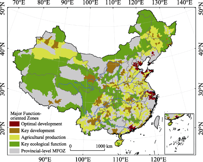
Figure 1 Major Function-oriented Zones of China (Fan, 2015)
Table 1 The summary on Major Function-oriented Zones
National-level functions Number of counties Land area
Number Percentage (×104 km2) Percentage (%)
Optimal development zones 134 8.50 13.87 2.15
Key development zones 361 23.46 67.76 10.51
Agricultural production zones 692 41.98 181.90 28.21
Key ecological function zones 419 26.06 381.25 59.13

Note: The number of counties is taken from statistics provided in the 2012 edition of the China county territories administrative boundary vector data, and statistical results are not consolidated with administrative districts in accordance with municipal districts.

2.3 National developing zones

In order to better reveal the characteristics and regional differences between each major function-oriented zone, this study divided China into four major zones (eastern, central, western and northeastern regions - see Figure 2 and Table 2) based on economic and social development factors. As the majority of optimal development zones are located along the coast, during the discussion of optimal development zones we have subdivided them into those in the Beijing-Tianjin-Hebei region, the Yangtze River Delta, the Pearl River Delta, central and southern Liaoning, and the Shandong Peninsula.
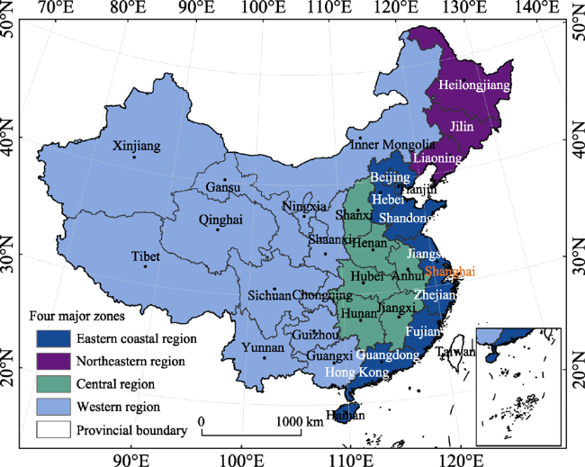
Figure 2 The distribution of major development zones
Table 2 Area and percentage of built-up area of Major Function-oriented Zones in 2013
Major Function-oriented Zones area (×104 km2) Built-up area
(×104 km2)
Proportion of national land area (%)
Optimal development zones 13.87 3.74 27.02
Key development zones 67.76 4.25 6.27
Agricultural production zones 181.90 7.61 4.18
Key ecological function zones 381.25 1.63 0.43

2.4 Rate and dynamic degree of built-up area expansion

In order to better show the speed and intensity of development of built-up area, this study used the indicators “built-up area expansion rate” and “dynamic degree of built-up area expansion”, both of which are stated as a percentage per year (%/yr). The formula for calculating the built-up area expansion rate is as follows:
$K=\left\{ \sum\limits_{ij}^{n}{\left( \Delta {{S}_{ij}}/{{S}_{i}} \right)} \right\}\times \left( 1/t \right)\times 100%$ (1)
where Si is the area at the start of monitoring built-up area, ΔSij is the total area of changed land type from and to built-up area during the monitored period, and t is time. The rate of change of built-up area, K, therefore reflects the built-up area expansion rate within the study area during the certain period.
The formula for calculating the dynamic degree of built-up area expansion is as follows:
$S=\left\{ \sum\limits_{ij}^{n}{\left( \Delta {{S}_{i-j}}/{{S}_{a}} \right)} \right\}\times \left( 1/t \right)\times 100%$ (2)
where Sa is the study area, ΔSi-j is the total area of changed land type from and to built-up area during the monitored period, and t is time. S is the dynamic degree of built-up area expansion, which reflects the intensity of change from others to built-up area within the study area during the certain period.

3 Results and analysis

3.1 Distribution of built-up area from Major Function-oriented Zones in 2013

The total area of built-up area in national Major Function-oriented Zones was 17.22×10⁴ km2 in 2013, accounted for 1.79% of China’s land area. Of this, optimal development zones, key development zones, agricultural production zones and key ecological function zones accounted for 3.74×10⁴ km2, 4.25×10⁴ km2, 7.61×10⁴ km2 and 1.63×10⁴ km2, respectively, or 27.02%, 6.27%, 4.18% and 0.43%, respectively, of the total land area within each of their function-oriented zones (Table 3). It is therefore possible to see the gradient feature of land development in different MFOZs. The area proportion of built-up area sub-class in different Major Function-oriented Zones is clearly different. The amount of urban land in optimal development zones has reached 50.82%, which reflects the urban-centered development model in those regions. The area proportion of urban land, rural residential land and land for factories, mines and transportation in key development zones was 36.4%, 44.41% and 19.19%, respectively, which reflected the equal condition on urban, rural and industrial development in key development zones. Rural residential areas accounted for 71.03% of agricultural production zones and 68.01% of key ecological function zones, which reflect the fact that the focus of these two types of zones is on rural development (Table 4). Thus, the area proportion of built-up area sub-class clearly reflected the different development stages of the MFOZs.
Table 3 The percentage of sub-classes of built-up area from Major Function-oriented Zones in 2013
Area of built-up
area (×104 km2)
Proportion of urban land (%) Proportion of rural residential land (%) Proportion of land used for factory, mining and transportation (%)
Optimal development zones 3.74 50.82 31.82 17.35
Key development zones 4.25 36.40 44.41 19.19
Agricultural production zones 7.61 18.33 71.03 10.64
Key ecological function zones 1.63 16.85 68.01 15.14
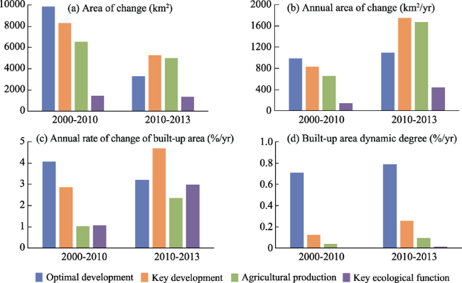
Table 4 The related indexes of urban expansion from Major Function-oriented Zones in 2000-2010 and 2010- 2013
Zones Total area of MFOZs (km2) Indicator 2000-2010 2010-2013
Optimal development zones 138,677.75 Area of change (km2) 9863.24 3277.02
Annual area of change (km2/yr) 986.32 1092.34
Built-up area annual rate of change (%/yr) 4.07 3.20
Built-up area dynamic degree (%/yr) 0.71 0.79
Key development zones 677,553.16 Area of change (km2) 8300.64 5238.82
Annual area of change (km2/yr) 830.06 1746.27
Built-up area annual rate of change (%/yr) 2.86 4.68
Built-up area dynamic degree (%/yr) 0.12 0.26
Agricultural production zones 1,819,041.33 Area of change (km2) 6551.95 5016.57
Annual area of change (km2/yr) 655.19 1672.19
Built-up area annual rate of change (%/yr) 1.02 2.35
Built-up area dynamic degree (%/yr) 0.04 0.09
Key ecological function zones 3,812,537.64 Area of change (km2) 1449.10 1337.47
Annual area of change (km2/yr) 144.91 445.82
Built-up area annual rate of change (%/yr) 1.07 2.98
Built-up area dynamic degree (%/yr) 0.004 0.012
In 2013, built-up area of optimal development zones was mainly located in Beijing and Tianjin of the Beijing-Tianjin-Hebei region, the Yangtze River Delta and the Pearl River Delta, and crossing area across central and southern Liaoning and the Shandong Peninsula. Built-up area of key development zones was mainly located in eastern coastal regions, Tianjin Binhai New Area, southern Hebei, the border region between Shandong and Jiangsu, central Shanxi, northern Henan and eastern Hubei, with relative concentrations in central Sichuan, central Shaanxi and Chongqing. Built-up area of agricultural production zones was mainly located in eastern coastal region, including large parts of Hebei, Shandong and Jiangsu, central region including large parts of Henan and Anhui, as well as western parts of the northeastern region. Built-up area of key ecological function zones was relatively dispersed and scattered across the country (Figure 3).
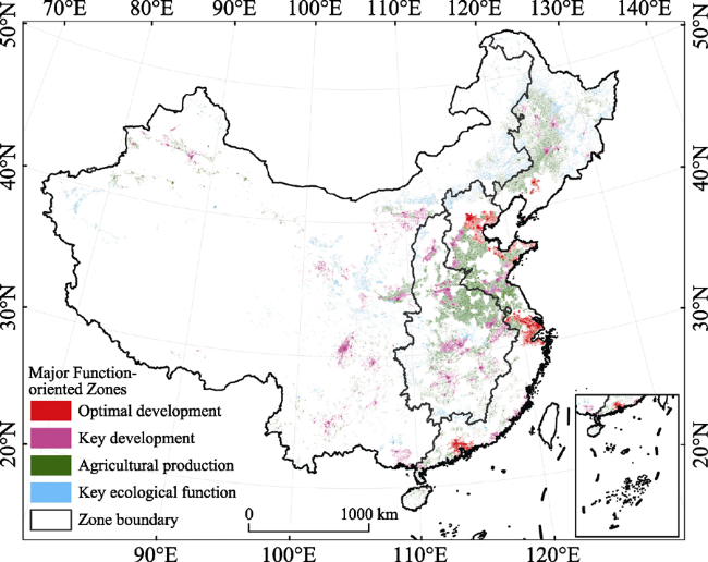
Figure 3 Spatial distribution of built-up area from Major Function-oriented Zones in 2013

3.2 Characteristics and regional differences of built-up area from Major Function-oriented Zones

The national expansion in built-up area in the period 2000-2010 mostly took place in the eastern coastal and central regions, with fast expansion also occurring in southern areas of China’s northeast and southern Gansu, eastern Sichuan and Chongqing in the west. Of these, areas with the most obvious increases in built-up area were located in Beijing and Tianjin, the Yangtze River Delta, the Pearl River Delta, Chongqing and Chengdu, with relatively increases in built-up area also occurring around provincial capitals in the central region (Figure 4a). Areas with the most notable increases in built-up area during the period 2010-2013 were mainly located in the Yangtze River Delta, followed by the Bohai Sea region, with insignificant increases in most of the northeastern regions (Figure 4b).
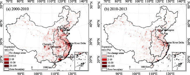
Figure 4 Urban expansion for Major Function-oriented Zones in China in 2000-2010 and 2010-2013
Compared to the period 2000-2010, the area of built-up area in four Major Function- oriented Zones increased to varying degrees (Figure 5b) in the period 2010-2013. The largest increase for 2000-2010, 986.32 km2/yr, took place in optimal development zones, whereas the same zones registered much slower growth in the period 2010-2013, with key development zones having the largest increase of 1746.27 km2/yr (Table 4). Compared to the former 10-year period, the latter three years saw a significant decrease in the growth rate of built-up area in optimal development zones, but a significant increase in the growth rate in other MFOZs (Figure 5c). Key development zones, for example, experienced a rate of change of 4.68%/yr, while the rate of change in key ecological function zones was 2.79 times faster for 2010-2013 compared with 2000-2010, though their average area of expansion remained the lowest (see Table 4). Moreover, during the last three years of the study period, the dynamic degree of each type of major function-oriented zone improved. Optimal development zones had the lowest increase, while key ecological function zones had the highest (Figure 5d). However, during the period 2010-2013, optimal development zones had the most dynamic built-up area, with a value of 0.79%/yr, and although dynamic degree was basically the same as the previous 10 years, they were still more dynamic than the three other types of Major Function-oriented Zones (Table 4).
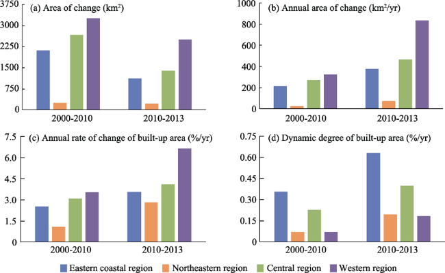
Figure 5 The charts of urban expansion related indexes from Major Function-oriented Zones in 2000-2010 and 2010-2013
During the periods from 2000 to 2010 and from 2010 to 2013, the areas of built-up area in four Major Function-oriented Zones all increased. The increased total area of built-up area from 2000 to 2010 is larger than the total increased area of built-up area from 2010 to 2013. But the annual area and annual rate of increased built-up area are of great difference between the four MFOZs. In the optimal development zones, the annual increased area of built-up area in 2010-2013 is almost the same with the one in 2000-2010, only with a little increase. And the annual increase rate decreased slightly. The expansion of built-up area in optimal development zones is mainly from the expansion of the large and medium scale cities. The increased area of built-up area is mainly from the encroachment of urban built-up area in the farmland around the city and suburbs. In the optimal development zones, which are the eastern coastal and the northeastern regions, the expansion shows a “slow down in the south, keep flat in the north, and speed up in the central part” spatial pattern. Compared to the previous decade, the annual change area and annual change rate of built-up area in the key development zones increased a lot in 2010-2013, almost twice the previous decade. The increase of built-up area is mainly from the sprawling of the rural and urban land. On the national scale, the expansion of built-up area in the key development zones shows a trend of “sharp acceleration in the western and northeastern, keep essentially slowing growth in the central and eastern coastal regions”. Compared with the previous decade, the annual change area and rate of built-up area in agricultural production zones increased significantly in 2010-2013. The annual change area has increased by 1.5 times while the annual change rate has increased by 1.3 times. The expansion of built-up area in the agricultural production zones shows a trend of “significant growth in the whole region, abrupt acceleration in the western”. In the key ecological function zones, compared to the 2000-2010, the annual change area of the built-up area increased by about 2 folds and the annual change rate increased by about 1.8 times during the period 2010-2013. The expansion of built-up area in the key ecological function zones shows a trend of “significant growth in the whole region, abrupt acceleration in the western part, and slowdown in the northeastern part”. Both in the agricultural production zones and key ecological function zones, the increase of built-up area include the expansion of both urban land and rural settlements. But because of the high proportion of the rural residential area, the expansion of built-up area is mainly because of the expansion of the rural residential land.
Overall, since the plan for Major Function-oriented Zones was promulgated, the rate of expansion of built-up area in optimal development zones has been effectively controlled and the annual rate of change has decreased significantly. However, because of a smaller total area, with a relatively large scope of built-up area to develop, the optimal development zones would remain most dynamic during the latter three-year study period. This shows that to some extent, since the implementation of the Major Function-oriented Zones plan, the urbanization process in optimal development zones has been transformed from a simple expansion of the urban land to the optimization of urban structure which is an optimum development direction. However, the annual rate of change and dynamic degree of built-up area in key development zones, agricultural production zones and key ecological function zones during the period 2010-2013 increased greatly. The high rate of and intense expansion of built-up area in key development zones shows that the urbanization in key development zones is speeding up. This is the most direct show of the performance of the Major Function-oriented Zones plan in the key development zones. Although the rate of change and dynamic degree of built-up area in agricultural production zones and key ecological function zones was still quite low in the last three years of the study, compared with the first 10 years of the 21st century, the growth rate was still excessive and not in line with the level required for “restricted development” in the MFOZ plan.

3.3 Characteristics and regional differences of built-up area from optimal development zones

There was fast expansion of built-up area in optimal development zones during the period 2000-2010, particularly in the Yangtze River Delta and Pearl River Delta regions, as well as in Beijing, Tianjin and Shenyang. Built-up area expansion in the 10 km × 10 km grids exceeded 10% on average, and in some cities with rapid economic growth, such as Guangzhou, Shenzhen, Beijing, Tianjin, Shanghai, Suzhou and Wuxi, expansion of built-up area in each 10 km × 10 km grid exceeded 20% (see Figure 6a). Compared to the previous decade, the speed of expansion of built-up area in many optimal development zones decreased, most noticeably in the Pearl River Delta, while Beijing, Tianjin and their surrounding areas experienced only small increases, and built-up area in the Yangtze River Delta region continued to increase significantly in the three years after the plan for Major Function-oriented Zones was promulgated (Figure 6b).
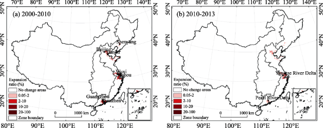
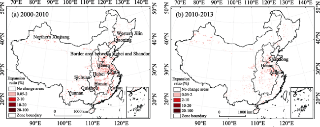
Figure 6 Spatial distribution of urban expansion in optimal development zones in China in 2000-2010 and 2010-2013
In terms of the amount, the annual area change of built-up area in the Pearl River Delta decreased from 261.44 km2/yr during the first 10-year study period to 104.28 km2/yr in the latter three-year study period, the largest decrease of the five regions under comparison. The annual area change of built-up area in the Yangtze River Delta increased rapidly from 414.34 km2/yr during the first study period to 634.96 km2/yr in the second, the biggest increase of the five regions. The other regions did not show significant increases or decreases (Figure 7b). Compared with the period 2000-2010, although there was a small increase in the annual rate of change of built-up area in southern and central Liaoning and the Shandong Peninsula in the period 2010-2013, the annual rate of change in the other three regions fell, with the most significant fall occurring in the Pearl River Delta, where the annual rate of change decreased by 5.1%/yr between the two periods. By comparison, the annual rate of change increased by 0.51%/yr between the two periods in the Shandong Peninsula, the highest increase of all the regions in the study (Figure 7c).
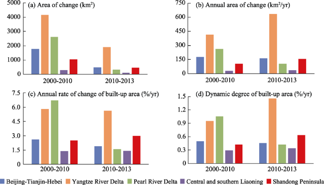
Figure 7 Urban expansion statistics of optimal development zones in China in 2000-2010 and 2010-2013
By analyzing dynamic degree of built-up area, the regions with the large changes in built-up area during the two study periods were the Yangtze River Delta and the Pearl River Delta. During the latter study period (2010-2013), the dynamic degree of built-up area in the Yangtze River Delta reached 1.46%/yr, an increase of 0.51%/yr, while the dynamic degree of built-up area in the Pearl River Delta decreased by 0.63%/yr, reaching 0.42%/yr. The dynamic degree of other regions showed no significant change (Figure 7d).
Overall, since promulgation of the plan for Major Function-oriented Zones, the speed and intensity of urban expansion in the Pearl River Delta has slowed quite markedly compared to the period before the plan’s promulgation, while the spatial layout of development of built-up area was improved significantly. By contrast, the speed and intensity of urban expansion in the Yangtze River Delta and Shandong Peninsula increased rather than decreased, most notably in the Yangtze River Delta, with considerably greater annual increases than the other optimal development zones. The speed and intensity of urban expansion in the Beijing-Tianjin-Hebei region and central and southern Liaoning remained roughly the same before and after the plan’s promulgation.

3.4 Characteristics and regional differences of built-up area from key development zones

Urban expansion in key development zones in the period 2000-2010 mainly took place in the eastern coastal region, central region and eastern part of the western region. Areas with the most notable urban expansion included the border area between Shandong and Jiangsu in the eastern coastal region; Changchun in Jilin and Harbin in Heilongjiang in the northeastern region; central Shanxi, northern Henan, eastern Hubei, northeastern Hunan, northern Jiangxi, and central and southern Anhui in the central region; and Erdos in Inner Mongolia, Chengdu in Sichuan, Chongqing, Kunming and Yuxi in Yunnan, and around Urumqi in Xinjiang in the western region (Figure 8a). The distribution of urban expansion in key development zones during the period 2010-2013 was similar to the decade before, with the most significant growth occurring in the eastern, central and southern parts of Anhui Province, Erdos in Inner Mongolia, Chengdu in Sichuan and Urumqi in Xinjiang (Figure 8b).
Figure 8 Spatial distribution of urban expansion in key development zones in China in 2000-2010 and 2010-2013
The annual area change of built-up area in the four main regions increased to varying degrees. The western region had the greatest increase in the last three years of the study period compared to the previous ten years, increasing from 326.17 km2/yr to 832.77 km2/yr. Moreover, although the overall amount of annual area change in the northeast was relatively small, it showed the greatest increase, of 2.85 times, compared to the previous decade. The eastern coastal region and northeast had the smallest increases (Figure 9b).
Figure 9 Urban expansion statistics of key development zones in China in 2000-2010 and 2010-2013
In the period 2010-2013, the western region had the highest annual rate of change of built-up area, reaching 6.65%/yr, and the northeastern region had the highest increase over the previous decade, from 1.10%/yr to 2.82%/yr (Figure 9c).
In terms of the dynamic degree of built-up area, the eastern coastal region continued to have the highest rate in the period 2010-2013, with 0.63%/yr, while the northeastern and western regions had the largest increases of 2.86 and 2.57 times, respectively, between the two periods (Figure 9d).
Overall, following promulgation of the plan for Major Function-oriented Zones, the average annual area of expansion of built-up area in key development zones exceeded that of optimal development zones, and all four major regions showed increases in the speed and intensity of expansion, most notably the northeastern and western regions. The western region also experienced the highest growth of all regions in terms of annual area increases and speed of growth. The eastern coastal and central regions increased at a slower rate, but urban expansion in each region was basically in line with the requirements set out in the plan for Major Function-oriented Zones.

3.5 Characteristics and regional differences of built-up area from agricultural production zones

Expansion of built-up area in agricultural production zones was relatively dispersed during the period 2000-2010, being scattered around the eastern coastal, central and southern part of northeastern regions, as well as the southeast corner of the western region. Although expansion of built-up area in agricultural production zones occurred throughout the country, overall levels were relatively low. Areas with agricultural production zones that experienced relatively high levels of expansion included the border area between Hebei and Shandong and the majority of Jiangsu and Fujian provinces in the eastern coastal region, Liaoning Province and western Jilin in the northeastern region, Henan, Anhui, Hunan and Hubei provinces in the central region, and Sichuan, Yunnan and Guizhou provinces and northern Xinjiang in the western region (Figure 10a). Compared to the previous decade, there was relatively little urban expansion in agricultural production zones during the period 2010-2013, and it was mainly concentrated in Henan, Shandong and Anhui provinces (Figure 10b).
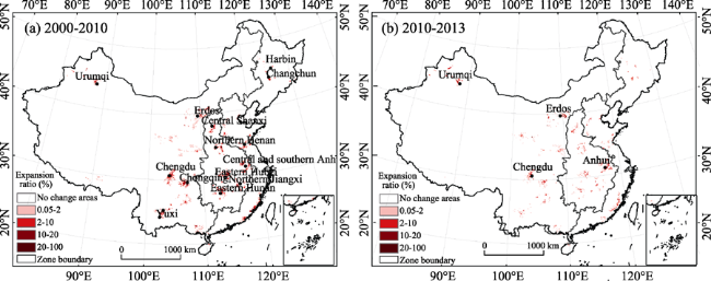
Figure 10 Spatial distribution of urban expansion in agricultural production zones in China in 2000-2010 and 2010-2013
Agricultural production zones in the eastern coastal region had the largest annual area of change in built-up area in the period 2010-2013 (590.47 km2/yr), while the western region experienced the fastest growth (442.36 km2/yr), which was 3.77 times more than the previous decade. Meanwhile, the northeastern and central regions also experienced significant increases (Figure 11b). The annual rate of change of built-up area in the period 2010-2013 was the fastest compared to the previous decade in the western region, which also had the highest overall amount, with 5.79%/yr. The rate of change of built-up area in agricultural production zones in the other three regions all showed varying degrees of growth (Figure 11c).
Agricultural production zones in the eastern coastal region also had the most dynamic built-up area, with values of 0.11%/yr in the period 2000-2010 and 0.22%/yr in the period 2010-2013, while the western region had the largest increase in dynamic condition, from 0.01%/yr in the period 2000-2010 to 0.05%/yr in the following three-year period, a five-fold increase. In addition, agricultural production zones in the central region experienced a significant increase in dynamic degree from 0.05%/yr in the period 2000-2010 to 0.14%/yr in the period 2010-2013 (Figure 11d).
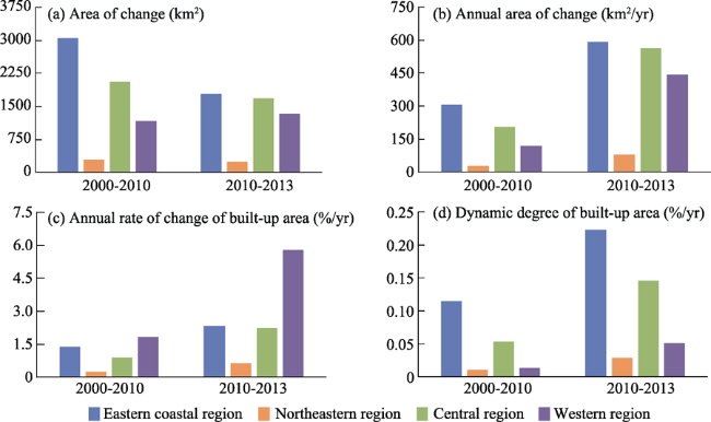
Figure 11 Urban expansion statistics of agricultural production zones in China in 2000-2010 and 2010-2013
Overall, since the plan for Major Function-oriented Zones was promulgated, the average annual area expansion of built-up area in agricultural production zones has exceeded that of optimal development zones. The annual rate of increase in area of built-up area in agricultural production zones in the eastern coastal, central and western regions in the 2010-2013 period was more than double that of the previous 10-year period, while the annual rate of increase in the western region was more than three times that of the previous period. Moreover, the speed and intensity of urban expansion in the four major regions also increased significantly, with the most notable increases occurring in the western region. With the exception of a few localities, the annual rate of change and dynamic degree of urban expansion in agricultural production zones in each of the main regions were below those in key development zones, which largely conformed to the requirements set out in the plan for Major Function-oriented Zones.

3.6 Characteristics and regional differences of built-up area from key ecological function zones

There was relatively little and scattered expansion of built-up area in national key ecological function zones, with less than 2% of 10 km × 10 km grids registering expansion. The little expansion that took place in the period 2000-2010 was mainly focused in eastern Hubei and the border areas of Hubei, Hunan and Chongqing in the central region, as well as eastern Inner Mongolia, southern Gansu and large parts of Shaanxi in the western region (Figure 12a). During the period 2010-2013, very little expansion of built-up area took place in key ecological function zones (Figure 12b).
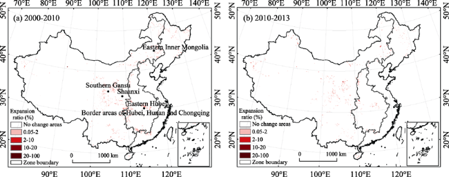
Figure 12 Spatial distribution of urban expansion in key ecological function zones in China in 2000-2010 and 2010-2013
Built-up area in key ecological function zones within each of the major regions expanded by a relatively small amount, with the western region showing the largest annual area of change, from 82.58 km2/yr in the period 2000-2010 to 294.69 km2/yr in the period 2010-2013, which was also the fastest rate of growth, followed by the central region, with an annual area of change 3.01 times higher in the latter period than the former (Figure 13b).
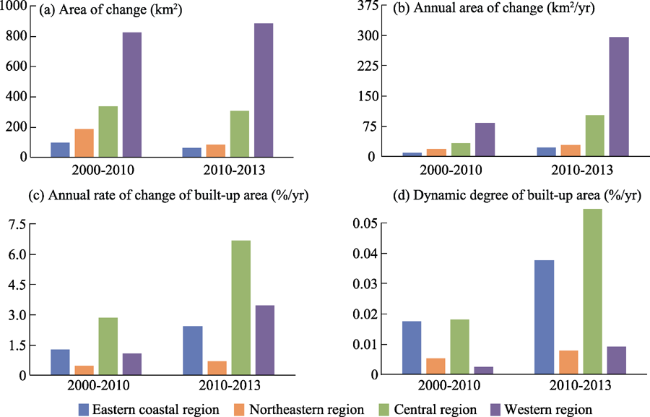
Figure 13 Urban expansion statistics of key ecological function zones in China in 2000-2010 and 2010-2013
The rate of change of built-up area in key ecological function zones in the central region reached 6.66%/yr in the period 2010-2013, the highest of the four major regions. During the same period, the rate of change of built-up area in key ecological function zones greatly exceeded that of built-up area in agricultural production zones and key development zones (Figure 13c). Meanwhile, the western region experienced the largest increase in the rate of built-up area change, 3.23 times higher in the period 2010-2013 than in the period 2000-2010. The eastern coastal region had the most dynamic built-up area in key ecological function zones in both periods, being 0.02%/yr and 0.04%/yr, respectively, while the western region had the fastest growth rate in terms of dynamic condition, with the latter period 3 times higher than the former period, though the total value was quite low, only 0.009%/yr for 2010-2013 (Figure 13d).
Overall, then, following promulgation of the plan for Major Function-oriented Zones, the speed and intensity of urban expansion in key ecological function zones increased to varying degrees in each of the four major regions, with the most notable increase in the western region and the weakest growth rate in the northeastern. It is worth noting that there was a significant increase in the annual rate of change and dynamic degree of urban and rural construction in the central region, with the annual rate of change considerably higher than agricultural production zones, and even higher than key development zones. It is therefore necessary to further strengthen management and control over this.

4 Conclusions

By interpreting built-up area expansion data from multiple periods from CLUD Major Function-oriented Zoning in China, the spatiotemporal characteristics of the expansion of built-up area were analyzed in the first decade of the 21st century and during the following three years. Using the indexes including the annual rate of change and dynamic degree of built-up area, this paper has revealed the characteristics and causes of changes in built-up area across the country and in the MFOZs located in the four major regions (eastern, central, western and northwestern) before and since promulgation of the plan for Major Function-oriented Zones.
(1) In 2013, built-up area in optimal development zones, key development zones, agricultural production zones and key ecological function zones as a proportion of the total land area in each of the zones was 27.02%, 6.27%, 4.18% and 0.43%, respectively. Urban built-up area accounted for 50.82%, 36.4%, 18.33% and 16.85% of the total built-up area in each type of zones, respectively, while rural built-up area was the opposite, which reflects the cascading nature of national land use in accordance with the layout of major functions.
(2) Compared with the period 2000-2010, annual growth in built-up area in optimal development zones decreased during 2010-2013, while it increased significantly in key development zones, agricultural production zones and key ecological function zones, with the average area expansion of urban and rural construction in key development zones and agricultural production zones exceeding that of optimal development zones, and the annual average area expansion of built-up area in key ecological function zones and the dynamic degree of urban and rural land remaining the lowest levels.
(3) At the regional scale, the average annual increase in built-up area in optimal development zones in the Yangtze River Delta region was significantly higher than that in optimal development zones in other regions; the average area increase and rate of increase of built- up area in key development zones was faster in the western region than in other regions; average annual area growth of built-up area in agricultural production zones in the northeastern, central and western regions was twice as high as the previous decade on average, while the annual rate of increase in the western region was three times as high as in the previous decade; the annual rate of change and increase in the dynamic degree of built-up area were most notable in key ecological function zones in the central region.
(4) The spatial pattern and characteristics of built-up area from 2010 to 2013 reflected the gradient feature development requirements of the plan for Major Function-oriented Zones. But the rate of increase locally in built-up area in optimal development zones, agricultural production zones and key ecological function zones is excessive, so management and regulation must be strengthened.
(5) This study indicated that by adopting a spatial-pattern change analytical method to carry out an analysis of the characteristics and the regional differences of built-up area in the periods before and after the promulgation of the plan for Major Function-oriented Zones, the variation in built-up area in different functional zones and different regions and the degree that such variation corresponds to the plan for Major Function-oriented Zones is made clear. The study indicated these methods and results were meaningful for future regulation strategies in optimizing national land development in China.

The authors have declared that no competing interests exist.

[1]
Chen Y Y, 2004. Some views on regional adaptation to global change research.Advances in Earth Science, 19(4): 495-499. (in Chinese)

[2]
Fan J, 2015. Draft of Major Function Oriented Zoning of China. Acta Geographica Sinica, 70(2): 186-201. (in Chinese)Major Function Oriented Zoning(MFOZ) is the blueprint for the future developmnt and protection pattern of China's territory, and has been raised to from major function zones planning to major function zoning strategy and major function zoning institution. From 2004 to2014, the author organized a series of research projects to compose MFOZ for the country,studied basic theory of regional function and MFOZ technical process, and proposed that space controlling zones of national and provincial scales can be divided into four types: urbanized zones, foodstuff-security zones, ecological safety zones, cultural and natural heritage zones. On this basis, major function zones of county scale should be transferred to optimized, prioritized,restricted, and prohibited zones. In this paper, a regional function identification index system comprising nine quantitative indicators(including water resources, land resources, ecological importance, ecological fragility, environment capacity, disaster risk, economic development level, population concentration and transport superiority) and one qualitative indicator of strategic choice is developed. Based on the single index evaluation, comprehensive evaluation using regional function suitability evaluation index is conducted, aiming at testing several key parameters including lower limit of protection zones and upper limit of development zones at the provincial level. In addition, a planning-oriented zoning method of major function zones is also discussed, which has brought the first MFOZ planning in China. According to the MFOZ caliber, it is forecasted that national spatial development intensity will rise from 3.48% in 2010 to 3.91% in 2020. Furthermore, according to caliber of the provincial integrated MFOZ planning, the area of optimized, prioritized and restricted zones accounts for 1.48%, 13.60%and 84.92%, respectively, and that of urbanized, foodstuff-security and ecological safety zones accounts for 15.08%, 26.11% and 58.81%, respectively. In combination of analyses of development level, resources and environmental carrying status and quality of the people's livelihood, the main characteristics of MFOZ were identified. Through verification, MFOZ draft of national and provincial scales, which is interactively accomplished with "MFOZ Technical Process" put forward by the author, is mostly above 80% identical with what have been forecasted.

DOI

[3]
Fan J, Sun W, Yang Z Set al., 2012. Focusing on the Major Function-oriented Zone: A new spatial planning approach and practice in China and its 12th Five-Year Plan.Asia Pacific Viewpoint, 53(1): 85-95.

[4]
Fan J, Sun W, Zhou Ket al., 2012. Major Function Oriented Zone: New method of spatial regulation for reshaping regional development pattern in China.Chinese Geographical Science, 22(2): 1-14.

DOI

[5]
Foley J A, DeFries R, Asner G Pet al., 2005. Global consequences of land use.Science, 309(5734): 570-574.Land use has generally been considered a local environmental issue, but it is becoming a force of global importance. Worldwide changes to forests, farmlands, waterways, and air are being driven by the need to provide food, fiber, water, and shelter to more than six billion people. Global croplands, pastures, plantations, and urban areas have expanded in recent decades, accompanied by large increases in energy, water, and fertilizer consumption, along with considerable losses of biodiversity. Such changes in land use have enabled humans to appropriate an increasing share of the planet's resources, but they also potentially undermine the capacity of ecosystems to sustain food production, maintain freshwater and forest resources, regulate climate and air quality, and amelio-rate infectious diseases. We face the challenge of managing trade-offs between immediate human needs and maintaining the capacity of the biosphere to provide goods and services in the long term.

DOI PMID

[6]
GLP Science Plan and Implementation Strategy (GLP), 2005. IGBP Report No.53/IHDP Report No.19, Stockholm, 64.

[7]
Kuang W H, Liu J Y, Zhang Z Xet al., 2013. Spatiotemporal dynamics of impervious surface areas across China during the early 21st century.Chinese Science Bulletin, 14: 1-11.中国在过去的十年经历了崭新的都市化和工业化。在这研究,我们基于在 2000 和 2008 之间的陆地使用 / 盖住变化和 ISA 数据集检验了构造陆地和不可渗透的表面区域(ISA ) 的动力学,它被国家资源和环境遥感信息站台提供。结果显示构造区域和 ISA 首先由于国家宏发展策略和快成长的经济的实现在这个时期由 3468.30 和 2212.24 km2/a 增加了。在 2008, ISA 在中国说明了 0.86% 全部的陆地区域。城市的陆地区域在 2000 和 2008 之间增加了 43.46% 。在这个时期的 1788.22 km2/a 的年度生长率在 1990 年代是乘那的 2.18。特别地,城市的 ISA 与 1348.85 km2/a 的年度生长率在 2000 和 2008 之间增加了 53.30% 。在 8 年期间,在中国的 ISA 很快增加了,特别在 Beijing-Tianjin-Tangshan 大城市的区域,珀尔河三角洲,长江三角洲,和西方的中国区域。增加的 ISA 可以潜在地影响水在主要的盆的环境质量。特别地,有 ISA 的 subbasins 的数字比 10% 大更加增加了,它在 Haihe 河,长江和珀尔里主要是分布式的河盆。在 2008, 14.42% 盆区域被增加的 ISA 影响。

DOI

[8]
Lambin E F, Baulies X, Bockstael Net al., 1995. Land-use and land-cover change (LUCC): Implementation strategy. A Core Project of the International Geosphere-Biosphere Programme and the International Human Dimensions Programme on Global Environmental Change. IGBP Report 48. IHDP Report 10. IGBP, Stockholm, 125.

[9]
Liu J Y, 1996. Macro-scale Survey and Dynamic Study of Natural Resources and Environment of China by Remote Sensing. Beijing: China Science and Technology Press. (in Chinese)

[10]
Liu J Y, Kuang W H, Zhang Z Xet al., 2014. Spatiotemporal characteristics, patterns and causes of land use changes in China since the late 1980s.Acta Geographica Sinica, 69(1): 3-14. (in Chinese)Land-use/land-cover changes (LUCCs) have links to both human and nature interactions. China’s Land-Use/cover Datasets (CLUDs) were updated regularly at 5-year intervals from the late 1980s to 2010, with standard procedures based on Landsat TMETM+ images. A land-use dynamic regionalization method was proposed to analyze major land-use conversions. The spatiotemporal characteristics, differences, and causes of land-use changes at a national scale were then examined. The main findings are summarized as follows.Land-use changes (LUCs) across China indicated a significant variation in spatial and temporal characteristics in the last 20 years (1990–2010). The area of cropland change decreased in the south and increased in the north, but the total area remained almost unchanged. The reclaimed cropland was shifted from the northeast to the northwest. The built-up lands expanded rapidly, were mainly distributed in the east, and gradually spread out to central and western China. Woodland decreased first, and then increased, but desert area was the opposite. Grassland continued decreasing. Different spatial patterns of LUC in China were found between the late 20th century and the early 21st century. The original 13 LUC zones were replaced by 15 units with changes of boundaries in some zones. The main spatial characteristics of these changes included (1) an accelerated expansion of built-up land in the Huang-Huai-Hai region, the southeastern coastal areas, the midstream area of the Yangtze River, and the Sichuan Basin; (2) shifted land reclamation in the north from northeast China and eastern Inner Mongolia to the oasis agricultural areas in northwest China; (3) continuous transformation from rain-fed farmlands in northeast China to paddy fields; and (4) effectiveness of the “Grain for Green” project in the southern agricultural-pastoral ecotones of Inner Mongolia, the Loess Plateau, and southwestern mountainous areas. In the last two decades, although climate change in the north affected the change in cropland, policy regulation and economic driving forces were still the primary causes of LUC across China. During the first decade of the 21st century, the anthropogenic factors that drove variations in land-use patterns have shifted the emphasis from one-way land development to both development and conservation.The “dynamic regionalization method” was used to analyze changes in the spatial patterns of zoning boundaries, the internal characteristics of zones, and the growth and decrease of units. The results revealed “the pattern of the change process,” namely the process of LUC and regional differences in characteristics at different stages. The growth and decrease of zones during this dynamic LUC zoning, variations in unit boundaries, and the characteristics of change intensities between the former and latter decades were examined. The patterns of alternative transformation between the “pattern” and “process” of land use and the causes for changes in different types and different regions of land use were explored.

DOI

[11]
Liu J Y, Zhang Z X, Xu X Let al., 2010. Spatial patterns and driving forces of land use change in China during the early 21st century.Journal of Geographical Sciences, 20(4): 483-494.Land use and land cover change as the core of coupled human-environment systems has become a potential field of land change science (LCS) in the study of global environmental change. Based on remotely sensed data of land use change with a spatial resolution of 1 km 1 km on national scale among every 5 years, this paper designed a new dynamic regionalization according to the comprehensive characteristics of land use change including regional differentiation, physical, economic, and macro-policy factors as well. Spatial pattern of land use change and its driving forces were investigated in China in the early 21st century. To sum up, land use change pattern of this period was characterized by rapid changes in the whole country. Over the agricultural zones, e.g., Huang-Huai-Hai Plain, the southeast coastal areas and Sichuan Basin, a great proportion of fine arable land were engrossed owing to considerable expansion of the built-up and residential areas, resulting in decrease of paddy land area in southern China. The development of oasis agriculture in Northwest China and the reclamation in Northeast China led to a slight increase in arable land area in northern China. Due to the "Grain for Green" policy, forest area was significantly increased in the middle and western developing regions, where the vegetation coverage was substantially enlarged, likewise. This paper argued the main driving forces as the implementation of the strategy on land use and regional development, such as policies of "Western Development", "Revitalization of Northeast", coupled with rapidly economic development during this period.

DOI

[12]
Liu J Y, Zhang Z X, Zhuang D Fet al., 2003. A study on the spatial-temporal dynamic changes of land-use and driving forces analyses of China in the 1990s.Geographical Research, 22(1): 1-12. (in Chinese)Supported by the key knowledge innovation projects,i.e., a preliminary study on the theories and techniques of the remotely sensed temporal-spatial information and digital Earth; and a study on the integration of national resources and environment and data sharing, the authors have set up a spatial-temporal information platform by the integration of the corresponding scientific and research achievements during the periods of the 8th- and 9th-Five Year Plan, which comprehensively reflected the features of land-use change, designed a series of technical frameworks on the spatial-temporal database construction based on remote sensing techniques, e.g., the construction of remotely sensed database and land-use spatial database of the mid-1980s, the mid-1990s and the end of the 1990s, which laid a foundation for the dynamic monitoring of land-use change and the corresponding studies. In this paper,the authors have analyzed comprehensively the features of land-use change in the 1990s, revealed the spatial-temporal change of land use supported by remote sensing and GIS technologies as well as analyzed the geophysical and socio-economic driving factors.The findings are as follows: the arable land has been increased in total amount, the balance of decrease in the south and increase in the north was resulted from the reclamations of grassland and forest land. On the whole, the forest land area had a process of decrease, and the decreased area was mainly distributed in the traditional forest areas. Areas with plentiful precipitation and heat in the south, however, had distinct effects of reforestation. The rural-urban construction land had a situation of persistent expansion, and the general expansion speed has been slowed down during the last five years of the 1990s with the exception of the Western China where the expansion speed has been accelerated. The land use change in China in the 1990s had distinct temporal and spatial differences due to two main reasons, which were policy control and economic driving. Hereby, conclusions and proposals brought forward by the authors were as follows: the spatial diversity rules of the modern land use change in China must be fully considered in the future land use planning. At the same time, the pertinence of physical geographical zones must be considered during the planning of eco-environment construction. And, based on the increasingly maturity of the infrastructure, the traditional thoughts on planning and management of resources must be shifted so as to fully realize the optimized allocation of land resources at regional scale.

DOI

[13]
Liu Y B, Li R D, Song X F, 2005. Grey associative analysis of regional urbanization and eco-environment coupling in China.Acta Geographica Sinica, 60(2): 237-247. (in Chinese)Based on the panel and serial statistical data, the main factors of regional urbanization and eco-environment coupling, temporal-spatial distribution of the coupling degrees have been researched. The results show: 1) Through grey associative degree analysis, it can be seen that the urban population transfer, economic growth, social service function and level are the main momentums for urbanization to affect eco-environment. Furthermore, the paper selects 16 items of urbanization and 10 items of eco-environment to reveal the coupling mechanism of regional urbanization and eco-environment. 2) The distribution of the coupling degrees basically conforms to the discrepant rule that the coupling degrees are lower in the eastern belt and the western belt, and higher in the middle with an inverse "U" shape. According to the coupling degree distributions and the stages of regional urbanization and economic development, the 31 provinces can be divided into four types, i.e., that are harmony, amelioration, confliction and low-level coupling, but the conflictive type is dominant, reaching 50%. 3) There exist significant phases and undulatory characteristics for the temporal evolvement of urbanization and eco-environment coupling, in which the former stage takes on inverse "U" shape and the latter stage rising curve shape.

[14]
Lu D D, Fan J, 2009. 2050: The Regional Development of China. Beijing: Science Press. (in Chinese)

[15]
McMahon G, Benjamin S P, Clarke Ket al., 2005. Geography for a Changing World: A Science Strategy for the Geographic Research of the U.S. Geological Survey, 2005-2015, Sioux Falls. SD: U.S. Geological Survey Circular, 1281: 1-76.

[16]
Salazar A, Baldi G, Hirota Met al., 2015. Land use and land cover change impacts on the regional climate of non-Amazonian South America: A review.Global & Planetary Change, 128: 103-119.Land use and land cover change (LUCC) affects regional climate through modifications in the water balance and energy budget. These impacts are frequently expressed by: changes in the amount and frequency of precipitation and alteration of surface temperatures. In South America, most of the studies of the effects of LUCC on the local and regional climate have focused on the Amazon region (54 studies), whereas LUCC within non-Amazonian regions have been largely undermined regardless their potential importance in regulating the regional climate (19 studies). We estimated that 3.6millionkm2 of the original natural vegetation cover in non-Amazonian South America were converted into other types of land use, which is about 4 times greater than the historical Amazon deforestation. Moreover, there is evidence showing that LUCC within such fairly neglected ecosystems cause significant reductions in precipitation and increases in surface temperatures, with occasional impacts affecting neighboring or remote areas. We explore the implications of these findings in the context of water security, climatic extremes and future research priorities.

DOI

[17]
Shi P J, Gong P, Li X B et al., 2000. Methods and Practice of Land Use/Cover Change. Beijing: Science Press. (in Chinese)

[18]
Turner B L, Skole D, Sanderson Set al., 1995. Land-use and land-cover change: Science/research plan. Joint Publication of the International Geosphere-Biosphere Programme (Report No.35) and the Human Dimensions of Global Environmental Change Programme (Report No.7). Stockholm: Royal Swedish Academy of Sciences.

[19]
Turner B L, Skole D, Sanderson Set al., 1995. Land Cover Change Science/Research Plan, IGBP Report No. 35, HDP Report 7. IGBP of the ICSU and HDP of the ISSC, Stockholm and Geneva.

[20]
Zhang Z X, Zhao X L, Wang X et al., 2012. Remote Sensing Monitoring of Land Use in China. Beijing: Star Maps Publishing House. (in Chinese)

Outlines

/