Research Articles

The episodic geomorphological-sedimentary evolution of different basins in the Fenwei Graben and its tectonic implication

  • HU Xiaomeng ,
  • ZHOU Tianhang ,
  • CAI Shun
Expand
  • Geography Department, Shanghai Normal University, Shanghai 200234, China

Author: Hu Xiaomeng, Professor, specialized in geomorphology and Quaternary research. E-mail:

Received date: 2017-06-05

  Accepted date: 2017-07-06

  Online published: 2017-09-07

Supported by

National Natural Science Foundation of China, No.41371021

Copyright

Journal of Geographical Sciences, All Rights Reserved

Abstract

There are a series of basins in the Fenwei Graben. Field survey found that there took place several paleolake regressions or intensive stream down-incisions in all basins during the Mid-Late Quaternary. The lowest and oldest paleosol/loess units overlying three of the lacustrine terraces or alluvial ones and some paleomagenetism data from the lacustrine sediment indicate that the onset times of three paleolake regressions or intensive stream down-incisions are synchronous with the formation of L9, L6 and L2 respectively in the Weihe Basin, S8, S5 and S1 respectively in the Linfen-Taiyuan-Xingding Basins, and L8, L5 and L1 respectively in the Datong Basin. The difference in the onset time of each lake regressions or intensive stream down-incision in different basins reveals that the farther the basin is from the Tibetan Plateau, the later it took place. Taking these field facts and the former research results in terms of the regional tectonic movement into account, it is inferred that the tectonic movement of the Tibetan Plateau most probably controlled such geomorphological- sedimentary evolution in the graben.

Cite this article

HU Xiaomeng , ZHOU Tianhang , CAI Shun . The episodic geomorphological-sedimentary evolution of different basins in the Fenwei Graben and its tectonic implication[J]. Journal of Geographical Sciences, 2017 , 27(11) : 1359 -1375 . DOI: 10.1007/s11442-017-1440-2

1 Introduction

China is topographically composed of three steps - I, II and III - which decline sequentially in elevation from west to east (Figure 1). Step I is the Tibetan Plateau (TP) with an average elevation of ca. 4500 m, being the highest of the three. It has been subject to tectonic uplift during the Cenozoic because of the collision of the Indian and Eurasian plates (Harrison et al., 1992; Coleman, 1995). Over the latest two decades, the uplift of the TP during the Late Cenozoic has attracted considerable scientific attention and the published literatures have documented multiple severe episodes of tectonic uplift experienced by the TP (Li et al., 1996; Cui et al., 1998; Wu et al., 2001). Apart from these researches, many scientists have concentrated upon the impact the TP uplift had on the regional climate change, particularly the change of East Asian monsoon (Xue et al., 1998; An et al., 2001; Shen et al., 2004; Li et al., 2014). However, there have been few studies of the effect of the TP uplift on landform development, particularly in some regions far away from the TP (Pan et al., 2011, 2012; Shi et al., 2015; Hu et al., 2016).
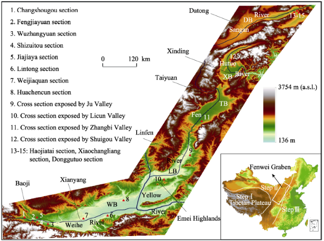
Figure 1 The map showing the landform and the locations of surveyed sections in the Fenwei Graben
The Fenwei Graben is located some distance to the northeast of the TP on Step II. It extends ~1700 km from southwest to northeast and is composed of a series of basins which are arrayed in an “S” shape and separated from each other by mountains and/or highlands. From southwest to northeast, they are the Weihe Basin (WB), the Linfen Basin (LB), the Taiyuan Basin (TB), the Xinding Basin (XB) and the Datong Basin (DB) (Figure 1). The Fenwei Graben was tectonically active during the Late Cenozoic (Chen, 1987; Wang, 1987; Zhang et al., 1995; Zhang et al., 1998, Qu et al., 2014; Yang et al., 2014). Previous research has demonstrated that some geomorphological events in some basins of the Graben coincided with some TP uplift episodes such as “Kunlun-Huanghe Movement” and “Gonghe Movement” during the Quaternary (Li et al., 1996; Cui et al., 1998; Wang et al., 2001; Hu et al., 2005). This would suggest that landform development in the Graben was most likely controlled by the tectonic movements of the Plateau, although there is at present little additional evidence to confirm this.
In this paper, we focus on the surveys of the river and lake terrace sequences in the WB, the LB, the TB, and the XB, and of changes in the lacustrine sedimentary rhythms of the DB. On the basis of the results of detailed field surveys, we elucidate the temporal differences in the episodic geomorphological-sedimentary evolution of these basins during the Mid-Late Quaternary. Furthermore, we analyze the factors which controlled the formation of these geomorphological-sedimentary features and any differences in the onset times of their evolutionary sequences. The aim of this research is to provide new evidence to help prove that the tectonic uplift of the TP governed the Fenwei Graben’s geomorphological-sedimentary development at this time.

2 Geographical and geological setting

The Fenwei Graben is located in the southern and eastern Chinese Loess Plateau. Its climate is dominated by the East Asian monsoon. Most of the region’s precipitation is brought by the warm and moist summer monsoon, whereas the cold and dry winter monsoon causes intense dust storms and loess deposition. The land surface is thus covered by a thick layer of loess (Liu, 1985; An et al., 1991a, 1991b). The Weihe River, the Fen River, the Hutuo River and the Sangan River flow across the Weihe Basin, the Taiyuan Basin and the Linfen Basin, the Xinding Basin, and the Datong Basin, respectively. Because of the constraint of some mountains or highlands, these rivers belong to different drainage basins. During the Quaternary, all these basins were occupied by outflow lakes, which experienced many regressions and transgressions (Mo, 1991; Xia, 1992; Wang et al., 1996; Hu et al., 2005). The area therefore saw the development of thick lacustrine sedimentary (in addition to alluvial) deposits and landforms.
Geologically, the graben came out in the Cenozoic under the control of tectonic extension, and the Weihe Basin, being in the southwestmost of the graben and nearer to the TP than the other basins, began to form in the Paleocene, and the other basins did in the Pliocene. The upper mantle underneath the graben uplifts relative to that underneath its surrounding mountains or highlands, and there occurs high heat flow in the graben basins (RGSSB, 1988); some of the basins experienced several episodic intensive volcano eruptions during the Mid-Late Quaternary (Li et al., 1998). The Graben is bounded by a series of neotectonically active normal faults in the surrounding mountains and highlands. Many alluvial terraces extending across these boundary faults are offset laterally and vertically; the vertical displacement of Neogene gravels during the Quaternary along some primary boundary faults reaches ~2500 m, with a lateral displacement of ~12.5 km (Hu et al., 2010). In addition, the Graben’s basins have experienced some great earthquakes during recorded history, e.g., the 1556 Huaxian Earthquake in the WB, the 1303 Hongdong Earthquake and the 1695 Linfen Earthquake in the LB, and 1038 Dingxiang Earthquake in the XB, all of which had estimated magnitudes of >7.0.

3 Methods

To constrain the ages of the studied landforms and sedimentary sequences, we adopted loess/paleosol sequence and paleomagnetic methods.
Loess sections in northwestern China are composed of less-weathered massive brown loess units and red maturely weathered soil units, forming a loess/paleosol sequence, and constituting a continuous terrestrial record of changing climatic conditions spanning more than two million years (Liu, 1985). Each of the loess and paleosol units in the sequence has been dated (Liu, 1985; Kukla and An, 1989; Ding et al., 1994) and can be used as a distinctive regional stratigraphic horizon of known age to constrain the ages of some sediments and landforms (Porter et al., 1992).
Loess/paleosols were deposited on the surfaces of lacustrine and/or alluvial terraces in the WB, the LB, the TB and the XB after their formation. Therefore, by dating the stratigraphic unit of the loess or paleosol just above the landform, we can constrain the age of that particular landform.
The accurate identification of each loess/paleosol unit relies on its distinctive physical characteristics (e.g., texture, structure, thickness, color, paleomagnetism and magnetic susceptibility) as well as its stratigraphic position in the regional succession. For instance, S5, being a special aeolian layer in northwestern China, is a paleosol complex with a distinctively greater thickness, darker brown color and thicker clay coating than other paleosol units (Han et al., 1998), with four other prominent paleosols (S4, S3, S2, S1) usually found above it. It is easy to be identified in the field. In loess/paleosol sections, the magnetic susceptibility of paleosols is much greater than that of loess. The Brunhes-Matuyama polarity boundary (B/M) is located in the loess layer L8; loess/paleosol units younger and older than L8 display a normal Brunhes polarity and a reversed Matuyama polarity, respectively (Yue and Xue, 1996). Using paleomagnetism to determine the B/M boundary in a loess/paleosol section can help us delineate L8 and other loess/paleosol units.
Changes in the lacustrine sedimentary rhythm in the DB display stacked regressive/transgressive sequences, recording past lake level drops and rises. Paleomagnetism can also be used to determine the B/M boundary in the lacustrine sections, and hence to constrain the onset times of some lake regression sequences.
There exist prominent characteristic differences between loess/paleosol stratigraphies and lacustrine sediment. Besides color difference, loess/paleosol stratigraphies exhibit no bedding, but lacustrine sediment does; a paleosol layer has pedogenic horizons (e.g., argillic and calcic horizons), but lacustrine sediment does not. It is therefore easy to distinguish the two kinds of deposition with the naked eye even in the field.
Prior to our field surveys, we analyzed topographic maps (scale: 1:50,000) and satellite images of the basins to determine which focal valleys should be investigated in greater detail. We therefore conducted research along some deeply-incised valleys, extending from the margins of each basin to its center, in order to trace the lacustrine sediment and find the lowest loess or paleosol unit immediately overlying it. In the field, paleomagnetic samples and magnetic susceptibility values were derived from both the overlying loess/paleosol strata and the lacustrine sediment; each of magnetic susceptibility samples was taken at an interval of 10cm and paleomagnetic ones were mostly selected at intervals of 100cm, but with some taken at 30cm intervals near the inferred reversal of the paleomagnetic field. All palaeomagnetic samples were measured in Nanjing University, China; all magnetic susceptibility samples were tested using an MS2 system in Shanghai Normal University, China.

4 Some graben geomorphological-sedimentary features

4.1 Geomorphological-sedimentary features of the Weihe Basin

The WB extends ~300 km from approximately west to east, and is up to 40 km wide. The Weihe River flows from west to east across the basin (Figure 1). The incised valleys of the Weihe River and its tributaries expose the sedimentary features of the different terraces in the basin. These exposed sections indicate no lacustrine sediment in the upper reaches of the Weihe River east of Xianyang, but rather two sets of alluvial deposits along each side of the river, forming five river terraces in all. In the lower reaches of the river, we see both lacustrine and younger alluvial sedimentary deposits, forming two lacustrine terraces and two alluvial ones.
4.1.1 Geomorphological-sedimentary sections in the upper reaches of the Weihe River
The Changshougou Section (N34°23.5′, E107°06.7′), a typical section of alluvial terrace T5 in the upper reaches of the river, is located on the north bank of the Weihe River, ~1 km west of Baoqi. From the base of the section upward, the sedimentary sequence consists of sedimentary rock, loess/paleosols of the Early Quaternary (Q1), alluvial terrace sediment, and loess/paleosols of the Mid-Late Quaternary (Q2-Q3); there exists an eroded surface between the alluvial sediment and the underlying Q1 loess/paleosols (Figure 2a). The terrace sediment is of alluvial rounded gravels ~10 m thick, with several intercalated thin sand layers, and its surface is ~130 m high above the present Weihe River level. The loess/paleosol stratigraphy overlying the terrace is ~70 m thick, and shows eight distinct paleosol units, with the lowest loess/paleosol unit deposited directly on top of the terrace being a loess unit. The paleomagnetic results show that the B/M boundary is located in the loess unit between the eighth paleosol unit and the seventh one, implying that the loess unit is L8, and that the eighth paleosol unit is S8. The lowest loess unit overlying the terrace can therefore be inferred as L9, indicating that this river terrace formed when L9 was depositing.
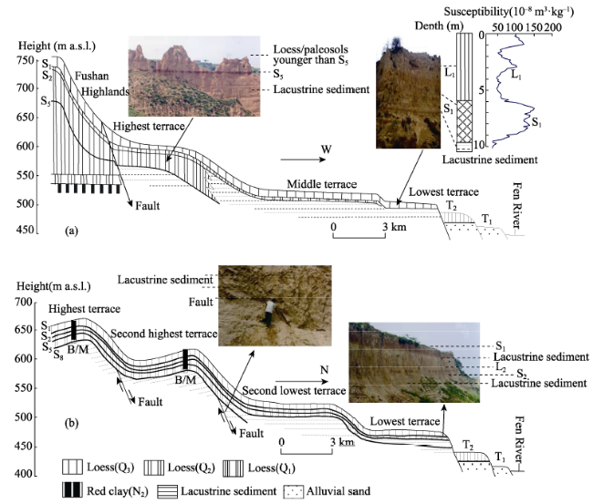
Figure 2 Geomorphological-sedimentary cross-sections in the upper reach (a) and the lower one (b) in the Weihe Basin
The Fengjiayuan and Wuzhangyuan sections are typical T4 sections. The Fengjiayuan Section is located on the south bank of the Weihe River (N34°19.9´, E107°07.8´), near Baoji. This river terrace is ~65 m high above the present river level and is composed of rounded gravels of ~3-5cm in diameter, with some sand lenses present. The thickness of the gravel layer is ~8 m. Underlying the terrace is granite, and overlying it is a 40 m-thick loess/paleosol stratigraphy, the lowest layer of which is a ~80 cm-thick loess unit. There are five distinct paleosols in the loess/paleosol stratigraphy; the fifth paleosol is a soil complex composed of three pedons of a greater thickness, and a darker brown color and thicker clay coatings than the other four paleosol units. It is inferred to be S5. The loess unit below it is L6, implying that this river terrace developed when L6 was depositing. The Wuzhangyuan Section is also located on the south bank of the river (N34°15.9´, E107°36.8´), about 42 km to the east of Baoji. The height of the terrace here is ~60 m above the present river level. The terrace sediment is composed of highly rounded gravels, whose diameters are mostly 2-5 cm (with the biggest being 15 cm). The thickness of the exposed sediment is ~10 m, and it contains an interbedded laminated silt and clay layer, though this layer’s lower part remains unexposed. A ~40 m-thick loess/paleosol stratigraphy overlies the terrace surface, of which the lowest and oldest loess unit is L6 (based on the identification of S5 in the section).
The Shizuitou and Jiajiaya sections are typical T3 sections. The Shizuitou Section is found on the south bank of the Weihe River near Baoji; the height of the terrace is ~30 m above the present river level. The exposed terrace gravels are ~25 m thick. A ~15 m-thick loess/paleosol stratigraphy has been deposited on the terrace surface, of which the lowest is a loess unit immediately above the terrace; one prominent paleosol has developed in it. Based on the magnetic susceptibility curve, we determined this prominent paleosol as S1; the loess unit below it is L2. The Jiajiaya Section is located on the north bank of the river, about 10 km to the east of Baoji (N34°20.4', E107°18.3'). The terrace height is ~25 m above the present river level and the exposed alluvial sediment is ~6 m thick, of which the lower part is valley gravels, and the upper floodplain deposits; 13 m-thick loess/paleosol strata L2 and S1 overlie the terrace. T2 and T1 are 12 m and 5 m above the present river level, respectively; both are capped by L1.
4.1.2 Geomorphological-sedimentary sections in the lower reaches of the Weihe River
The stepped nature of the landforms beside the Weihe River is clear to see in its lower reaches (Figure 2b). The Lintong Section, located on the south bank of the Weihe River, is exposed by brickworks ~5 km east of Lintong (N34°25.3′, E109°16.7′). This section shows the composition of the T4 sedimentary profile. Its lower part is composed of laminated grey-green fine sand, silt and clay, which were deposited in a paleolake, implying that T4 here is a lacustrine terrace; the thickness of this exposed lacustrine sediment is ~38 m, and the top surface of the sediment is ~60 m above the present river level. Overlying the lacustrine sediment is a ~30 m-thick loess/paleosol stratigraphy, in which there have developed five prominent paleosols; the lowest layer directly deposited on the lacustrine terrace is a loess unit. We took magnetic susceptibility samples from the overlying loess/paleosol strata in the field. Based on the magnetic susceptibility features of the loess/paleosol strata, and the features of the fifth paleosol, which is complex and consists of three pedons, we inferred that the fifth paleosol is S5, and the lowest loess unit is L6, indicating that the paleolake regression took place synchronously with the formation of L6.
T3 is also a lacustrine terrace in this sector, with typical sections being the Weijiaquan and Huachencun sections. The Weijiaquan Section is an artificial exposure, located next to a brickworks on the north bank of the river (N34°20.6′, E108°39.7′). The lower part of the section is composed of laminated grey-green silty clay, with interbedded pale-yellow silt and fine sand; some snail shell fossils are scattered throughout the lacustrine terrace. The height of the top surface of the terrace is ~40 m above the present river level. A ~15 m-thick loess/paleosol stratigraphy overlies the terrace, and the lowest layer, in direct contact with the lacustrine terrace, is a loess unit. There is only one distinctive paleosol in the loess/paleosol stratigraphy, which is complex, with a reddish-brown color. It is inferred to be S1; the lowest loess unit is inferred to be L2. The Huachencun Section (N34°53.9′, E109°47.5′) shows the same sedimentary features as the Weijiaquan Section. The lower part is composed of lacustrine sediment, with well-developed horizontal beddings; the upper part is a loess/paleosol stratigraphy, of which the oldest and lowest layer is L2. The height of the lacustrine terrace surface is ~38 m above the present river level.
Two younger alluvial terraces can be identified in some artificial and natural exposures close to today’s Weihe River, and both are overlain by L1 aeolian sediment.

4.2 Geomorphological-sedimentary features of the three basins of Linfen, Taiyuan and Xinding

4.2.1 Geomorphological-sedimentary features of the Linfen Basin
The LB is a reversed “L” in shape, extending NNE to SSW in its northern sector, with a length of ~80 km, and a width of up to 40 km; and ENE to WSW in its southern sector, with a length of ~60 km, and a width of ~30 km (Figure 1).
In its northern sector, there is an extensive platform ~20 km in width to the east of the Fen River. The Ju valley, a tributary of the Fen River, is incised into the platform, exposing its geomorphological-sedimentary features. Field surveys reveal that the platform is composed of three lacustrine terraces, each with different heights and different loess/paleosol sequences overlying them (Figure 3a).
Figure 3 Geomorphological-sedimentary cross-sections in the northern sector (a) and the southern one (b) of the LB
The highest terrace is ~4 km wide from east to west, and ~110 m above the present Fen River level. Its eastern boundary is a normal fault which separates it from the Fushan Highlands and defines the eastern margin of the basin. The base of the terrace is composed of lacustrine sediment, which is composed of laminated grey-green silt and fine sand. The thickness of the exposed lacustrine deposit is ~30 m, but its lower part remains unexposed. The loess/paleosol stratigraphy overlying the terrace is up to 30 m thick, and includes five well-developed paleosols. The lowest loess/paleosol unit, developed directly on the top of the lacustrine sediment, is the fifth paleosol. This paleosol displays a darker, more reddish-brown color and thicker clay coatings than the four others; it is inferred to be S5. At the front of this terrace, S5 extends and dips toward the lower terrace, and is partially capped by the lower lacustrine sediment, before finally dying out.
The middle terrace is ~8 km wide and 60 m above the present level of the Fen River. It is composed of laminated silt and fine sand, with interlayered clay forming its base. A ~15 m-thick loess/paleosol stratigraphy has been deposited on the surface of the terrace, where two prominent paleosols have developed. The lowest loess/paleosol unit above the lacustrine sediment is inferred to be S2, based on its stratigraphic position in the loess/paleosol succession, as well as its magnetic susceptibility features.
The lowest terrace is ~3 km wide from east to west, and lies 45 m above the Fen River’s present level. The terrace base is also composed of laminated clay, silt and fine sand. There is a ~10 m-thick loess/paleosol stratigraphy overlying the lacustrine sediment; the lowest unit is a paleosol. From its magnetic susceptibility features, this paleosol is inferred to be S1.
Besides these three lacustrine terraces, there are two well-developed alluvial terraces within the basin, both of which are lower in height than the lowest lacustrine terrace.
The Emei Highlands form the southern boundary of the basin (Figure 1). Four descending lacustrine terraces are discernible from the highland margins to the center of the basin. The Licun Valley is a long, deeply-incised valley which cuts across these terraces and thus clearly shows their geomorphological-sedimentary differentiation (Figure 3b).
The highest lacustrine terrace surface is 210-220 m above the present Fen River level; the loess/paleosols overlying the lacustrine sediment are ~48 m thick. Of these, the lowest loess/paleosol unit is a reddish paleosol. The second highest terrace is 160-170 m above the Fen River’s present level, and is overlain by loess/paleosols ~50 m thick; the lowest loess/paleosol unit is also a paleosol. Paleomagnetic samples were taken from the overlying loess/paleosol strata. Paleomagnetic results show that the lowest paleosol unit overlying the two terraces is S8, indicating that both terraces were almost concurrently exposed subaerially. The present-day surfaces of the two terraces are southward-tilting reverse slopes, with normal faults between them and in front of the second highest terrace. The difference in elevation between the two terraces may have resulted from the tectonic movement of the normal fault between them. At the front of the second highest terrace, the S8 paleosol can be seen to dip toward, and extend into, the lower terrace’s lacustrine sediment before petering out.
The second lowest terrace is ~110 m above the present Fen River level, and is overlain by a loess-paleosol stratigraphy ~30 m thick. The lowest aeolian sediment in direct contact with the lacustrine sediment is a mauve paleosol layer, with a well-developed manganese membrane. Owing to its significant clayification, mauve appearance and stratigraphic position within the loess/paleosol succession, it can be identified as S5. At the front of this terrace, this paleosol dips toward the lower terrace and extends into the lowest terrace’s lacustrine sediment. A further tracing survey taken downvalley found that S5 extends nearly to the center of the basin and occurs in sections near the present Fen River, where a layer of younger lacustrine sediment up to 26 m thick overlies it.
The lowest terrace is ~50-40 m above the present Fen River level, with marked differences in the sedimentary features of its far side and frontage. At the far side of the terrace, an exposed vertical section shows that the underlying sediments (from bottom to top) are old lacustrine, S5, young lacustrine, S2, L2, S1, and L1 in turn; the sedimentary stratigraphy at the terrace frontage (from bottom to top) runs through old lacustrine, S5, young lacustrine, S2, L2, younger lacustrine, S1, and L1 in turn (Figure 3b), with a layer of celadon lacustrine sediment covering L2 and underlying S1. This terrace can therefore be divided into two sub-terraces: one is directly capped by S2, and the other by S1.
Two alluvial terraces also developed in this sector after the formation of the lowest lacustrine terrace.
4.2.2 Geomorphological-sedimentary features of the Taiyuan Basin
The TB extends from NE to SW, with a length of ~120 km, and a width of up to 40 km (Figure 1). There is a lacustrine platform in its southeastern part. The deeply-incised Zhangbi Valley exposes its geomorphological-sedimentary features. This platform is composed of three lacustrine terraces, and their surfaces decrease step by step in height from upvalley to downvalley. Loess/paleosol strata of different sequences and thicknesses have been deposited on the surfaces of these terraces (Figure 4a).
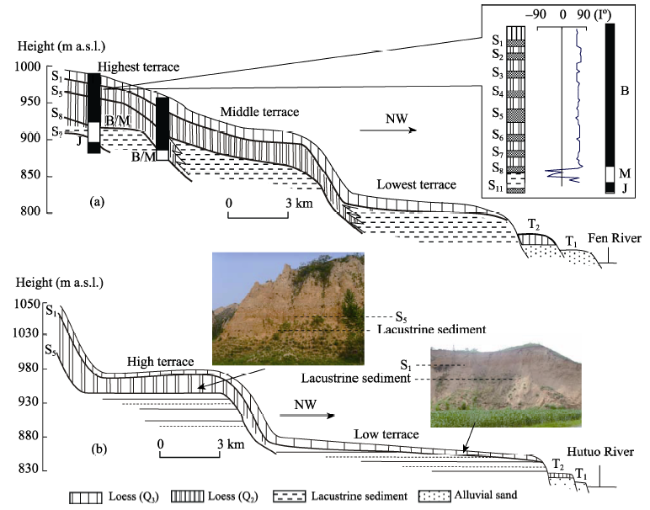
Figure 4 Geomorphological-sedimentary cross-section in the Taiyuan Basin (a) and Xinding Basin (b)
I: Magnetism Inclination; J: Jaramillo Normal Polarity Subzone
The highest terrace is ~120 m above the present Fen River level; its lacustrine sediment is composed of bedded celadon silt and fine sand, with some fragments of snail shells. A nearly 50 m-thick aeolian sedimentary layer has been deposited on this terrace; eight paleosols can be identified in the loess/paleosol section. The eighth, or lowest, paleosol has developed directly on the surface of the lacustrine sediment. Beneath the lacustrine sediment is another older paleosol. Paleomagnetic results show that the eighth paleosol overlying the lacustrine sediment is S8. The middle terrace stands about 40 m lower than the highest one; the lacustrine sediment of the terrace base is composed of compacted grey clay and silt, locally interlayered with fine sand. The loess/paleosol sediment overlying this terrace is ~30 m thick, and S5 has developed directly on its surface.
The lowest terrace is ~60 m lower than the middle one, and is overlain by a loess/paleosol stratigraphy ~15 m thick. The lacustrine sediment of this terrace is composed of silt and light-colored fine sand, with many snail shell fragments. The lowest paleosol in the overlying loess/paleosol stratigraphy is S1. We did not find a lacustrine terrace on this platform correspondent to that in the LB, i.e. proximally capped by S2.
There are, in addition, two younger and lower alluvial terraces along the present Fen River.
4.2.3 Geomorphological-sedimentary features of the Xinding Basin
The XB is a “C” in shape, extending NNE-SSW in its northern sector, and SW-NE in its southern one. It is ~120 km in length, and 20-40 km in width, and the Hutuo River flows across the basin (Figure 1). There is a lacustrine platform to the east of the Hutuo River in the northern sector of the basin; the Shuigou Valley is incised into it, uncovering the platform’s geomorphological-sedimentary features. The stepped landforms and differences between the overlying loess/paleosol sequences within the lacustrine sedimentary profiles show that this lacustrine platform is composed of two lacustrine terraces (Figure 4b). The higher lacustrine terrace is ~100 m above the present Hutuo River level, and is composed of laminated, and somewhat compacted, grey-green clay and silt. Overlying the terrace is a ~30 m-thick loess/paleosol stratigraphy, in which five paleosols have developed, the lowest being S5. The lower lacustrine terrace is ~45 m above the present Hutuo River level and is composed of laminated silt and fine sand, intercalated with thin bright-reddish clay layers. This lacustrine sediment is somewhat loose. A ~12 m-thick loess/paleosol stratigraphy has been deposited on this terrace, with the lowest paleosol being a prominent S1. Additionally, two young alluvial terraces have also developed.
There may have been intensive erosion of this lacustrine platform in the basin in the past; we did not find any lacustrine terraces which corresponded to those directly capped by S8 and S2 in the LB.

4.3 Sedimentary features of the Datong Basin

The DB extends from approximately west to east, to a length of ~250 km and a width of 20-30 km. The Sangan River flows from west to east across the basin (Figure 1). Because of the deposition of proluvial fans from the surrounding mountains, the lacustrine landforms in the basin have become partly modified and any stepped terraces blurred, but some exposed sedimentary sections do nevertheless show changes in the lacustrine sedimentary rhythm, indicating past paleolake level changes. In the southeastern part of the basin, the down-incision of the Sangan River has exposed three thick sedimentary sections: the Haojiatai Section (40°13.4´N, 114°39.5´E); the Xiaochangliang Section (40°13´N, 114°39.7´E); and the Donggutuo Section (40°13.3´N, 114°39.9´E). Many paleolithic relics have been found in these sections (You et al., 1980; Tang et al., 1995). The three sections are located at the center, near-shore area and the lakeside of the paleolake, respectively, and the lowest exposed sedimentary layers were initially deposited in 1.66 MaBP, 1.38 MaBP and 1.10 MaBP, respectively (Yang, 2000; Zhu et al., 2001, 2004). We made detailed surveys of the sedimentary rhythms of these three sections, and used paleomagnetic methods to date their upper parts (Figure 5).
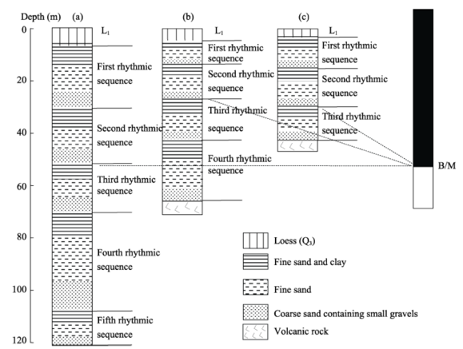
Figure 5 The rhythm and magnetic polarity of several lacustrine sediment sections in the Datong Basin
a. Haojiatai Section, b. Xiaochangliang Section, c. Donggutuo Section
The exposed sediment of the Haojiatai Section is ~122 m thick, and exhibits five sedimentary rhythmic cycles. Each rhythmic cycle begins with sand, or sand with some small gravels, and gradually changes into fine sand, silt and clay in an upward direction, displaying a classic lake regression-transgression sedimentary sequence. The sedimentary layers from 122.3 m to 110.2 m, 110.2 m to 72.7 m, 72.7 m to 50.5 m, 50.5 m to 34.1 m, and 34.1 m to 9.8 m in depth constitute the fifth, fourth, third, second and first sedimentary rhythm sequences, respectively. Overlying the lacustrine sediment is ~10 m thick loess layer L1. Paleomagnetic results show that the B/M boundary is located at the base of the second sedimentary rhythmic sequence. The base of the Xiaochangliang Section is composed of volcanic rock. The lacustrine sediment overlying this rock is ~64 m thick, and four sedimentary rhythmic cycles can be identified. The sedimentary layers from 64.3 m to 42.2 m, 42.2 m to 29.9 m, 29.9 m to 19.2 m, and 19.2 m to 7.3 m in depth constitute the fourth, third, second and first sedimentary rhythmic sequences, respectively. Overlying the lacustrine sediment is a ~7 m thick layer loess L1. Paleomagnetic results show that the B/M boundary is also located at the base of the second sedimentary rhythmic sequence. The Donggutuo Section is ~44 m in depth, and its base is also composed of volcanic rock; three sedimentary rhythmic cycles can be identified within the section. The sedimentary layers from 44.3 m to 30.2 m, 30.2 m to 18.1 m, and 18.1 m to 7.1 m in depth constitute the third, second and first sedimentary rhythmic sequences, respectively. A L1 layer ~7 m thick overlies the lacustrine sediment. The B/M boundary is located at the base of the second sedimentary rhythmic sequence. Magnetostratigraphic dating of the loess/paleosol sequence typical of northwestern China indicates that the B/M boundary is located in loess L8 (Yue and Xue, 1996). This would indicate that the onset time of the second sedimentary rhythmic sequence in these three sections is synchronous with L8.
Assuming that the duration of the deposition of every sedimentary rhythmic sequence is proportional to its thickness, an estimation of the onset time of the first sedimentary rhythmic sequence was made. Because the B/M boundary is located at the base of the second sedimentary rhythmic sequence, and the first one is capped by L1, we took the age of the B/M boundary to be 0.73 MaBP, and that of L1 to be 0.07 MaBP (Liu et al., 1994; Ding et al., 1994; Yue and Xue, 1996). The onset time of the first sedimentary rhythmic sequence can be calculated using the formula D=H1/H1+2×(0.73-0.07)+0.07 (D: the onset time of the first sedimentary rhythmic sequence; H1: the thickness of the first sedimentary rhythmic sequence; H1+2: the total thickness of the first and the second sedimentary rhythmic sequences). Results show that the onset times of the first sedimentary rhythmic sequence in the Haojiatai, Xiaochangliang and Donggutuo sections are ~0.464 MaBP, 0.417 MaBP and 0.384 MaBP, respectively. Loess L5 was deposited between ~0.482 MaBP and 0.418 MaBP (Ding et al., 1994), so it can be inferred that the onset time of the first sedimentary rhythmic sequence is nearly synchronous with L5.

5 Temporal differences in the episodic geomorphological-sedimentary evolution of the basins in the Fenwei Graben

In the WB, the oldest loess/paleosol units overlying the terraces T5, T4 and T3 in the upper reaches of the Weihe River indicate that the river experienced three intensive down-incisions when L9, L6 and L2 were depositing, respectively. In the river’s lower reaches, the existence of two lacustrine terraces indicates that the paleolake experienced two significant regressions when L6 and L2 were depositing. The height differences between the terraces demonstrate that both paleolake regressions saw drops in their levels of >20 m. The two lacustrine terraces correspond temporally to the alluvial terraces T4 and T3 in the river’s upper reaches. This shows that three episodic intensive stream down-incisions and/or substantial paleolake regressions occurred in the WB during the Mid-Late Quaternary.
In the LB, the two transverse geomorphological-sedimentary sections show that four paleolake regressions occurred during the Mid-Late Quaternary. The first paleolake regression occurred when S8 began to develop. The drop in paleolake levels during this regression is calculated to be ~40-50 m, based on the height difference between the two adjacent terraces. The second paleolake regression occurred when S5 began to develop. This regression caused the paleolake level to decline >60 m, and may have left the southern sector of the basin empty, because S5 extends nearly to the center of this sector. The third paleolake regression occurred when S2 began to form; sedimentary evidence shows there was a drop in the paleolake levels of ~10 m. The fourth paleolake regression took place when S1 began to form. This regression was so extensive that nearly all the lakewater drained away so that the paleolake effectively disappeared, with the Fen River emerging in the lowest part of the basin. The paleolake regressions found in the LB are also recorded in the TB, with the exception of the third one. In the XB, only two lake regressions corresponding to the first and third ones in the LB are apparent, and the others have not been yet been identified in the field. Each of the lake regressions in the TB and XB, based on the height differences between adjacent terraces, shows drops in paleolake levels exceeding several tens of meters. We can therefore infer that four episodic paleolake regressions occurred in the LB, TB and XB during the Mid-Late Quaternary.
Changes in the sedimentary rhythms in the DB show that several paleolake regression-transgression cycles occurred during the Mid-Late Quaternary. The last two sedimentary rhythmic sequences show that the onset times of the last two paleolake regressions are synchronous with the deposition of L8 and L5, respectively. The lacustrine sediment in the basin is extensively capped by L1, indicating that a significant regression, ending with the disappearance of the paleolake, occurred when L1 began to deposit. Therefore, three episodic paleolake regressions took place in the basin during the Mid-Late Quaternary.
These findings reveal that there are temporal differences in the episodic paleolake regressions and/or intensive stream down-incisions in this series of basins in the Fenwei Graben, except for the paleolake regression occurring in the LB when S2 began to develop. In the WB, three of the intensive stream down-incisions and/or paleolake regressions occurred when L9, L6 and L2 were depositing, respectively; in the LB, TB and XB, three of the paleolake regressions took place when S8, S5 and S1 began to develop, respectively; in the DB, three paleolake regressions occurred synchronously with each of the formations of L8, L5 and L1, respectively. From the WB, through the LB, TB and XB, to the DB, the occurrence of the lake regressions and/or intensive stream down-incisions in each of the three episodes grows later and later, displaying temporal differences between L9-S8-L8, L6-S5-L5, and L2-S1-L1, respectively. In other words, the farther the basin is from the TP, the later the episodic geomorphological-sedimentary event occurred.

6 Discussion

The episodic geomorphological-sedimentary evolution in the Graben was not the result of paleoclimate changes. This is because: 1) the occurrences of several lake regressions in the LB, TB and XB are almost synchronous with the formation of some paleosols, when the paleoclimate was warm and wet and was accompanied by high annual precipitation, raising paleolake levels (An et al., 1991b, Porter and An, 1995); 2) although several paleolake regressions in the WB and DB occurred when some loess units were depositing and the paleoclimate was dry, the other episodes of loess deposition did not cause regressions and paleolake regressions identified do not coincide with the dry-wet climate changes recorded by loess-paleosol sequences during the Quaternary; 3) there are no calcium carbonate crystals on the surface of each lacustrine terrace, indicating that the paleoclimate was not dry enough to make the lake levels regress significantly; and 4) previous research has shown that paleoclimate changes during the Mid-Late Quaternary brought about only minor paleolake level fluctuations of ~2-3 m in these outflow basins (Hu et al., 2005). All these factors suggest that not climate but tectonic movement may be the primary factor affecting episodic geomorphological-sedimentary evolution in the Graben.
Although the Fenwei Graben is located between the subduction zone of the western Pacific Plate and the TP, some researches have suggested that the regional tectonic stress field and tectonic movement in north and northwest China (including the Fenwei Graben) during the Cenozoic were both strongly controlled by the movement of the TP, and were little related to the northwestward subduction of the western Pacific Plate (Zhang et al., 1979; Chen, 1987; Zhu et al., 2000; Shi et al., 2015). Other studies (Wang, 1979, Deng et al., 1982) have indicated that the development of the Graben is closely related to the upper mantle uplift underneath the Graben, causing the basins to extend orthogonally. Based on these facts, we deduce that the episodic geomorphological-sedimentary evolution in the Graben is most probably controlled by the tectonic movement of the TP.
There are two hypotheses concerning the nature of the tectonic movement of the TP. One is called “crustal thickening” (England and Houseman, 1986), and the other is called “lithosphere extrusion” (Tapponnier et al., 1982; Lavé et al., 1996). Both state that an intensive movement of viscous material beneath the TP occurred during the collision of the Indian and Eurasian plates. The collision of the two plates would have forced the upper mantle material underneath the TP to move in an outward direction, and some of it may have moved northeastward and then moved upward along the Fenwei Graben where the geological structure is much fractured. The teleseismic tomography and magnetic anomalies identified along northern and northeastern margins of the TP even show that the deep materials there mainly flow northward and northeastward (Wittlinger et al., 1996; Gao et al., 2015); the uplifted Moho, high heat flow and volcano eruptions in the Fenwei Graben all indicate the existence of such upward movement (Li et al., 1998; Wang et al., 2014; Gao et al., 2015). Because the basins in the graben were all outflow lakes during the Quaternary, intensive upward movement of upper mantle material in depth of the graben basins would raise the basins’ floors to drain much water and caused lake regressions (Chen and Hu, 2017). We speculate that it is this process which resulted in some geomorphological-sedimentary changes in the Graben’s basins. Because of the differences in distances from the TP, the time when the upward movement of the upper mantle material occurred is different in different basins; the farther it is from the TP, the later the upward movement of the upper mantle material.

7 Conclusions

Except for the paleolake regression which took place in the LB when S2 began to develop, there are three significant episodic paleolake regressions and/or intensive stream down-incisions in the WB, LB, TB, XB and DB in the Fenwei Graben during the Mid-Late Quaternary. In the WB, there occurred three intensive down-incisions or paleolake regressions when L9, L6 and L2 were depositing, respectively; in the LB, TB and XB, three paleolake regressions took place when S8, S5 and S1 were developing, respectively; in the DB, three paleolake regressions occurred synchronously with the deposition of L8, L5 and L1, respectively. There are temporal differences in each of the three episodic paleolake regressions and/or intensive down-incisions in these basins. The farther the basin is from the TP, the later the onset time of each of the three paleolake regressions and/or intensive river down-incisions.
These paleolake regressions and/or intensive river down-incisions were caused by regional tectonic movement, not paleoclimate changes, and the tectonic movement of the TP has probably played a most important role in the Graben’s episodic geomorphological-sedimentary evolutions.

The authors have declared that no competing interests exist.

[1]
An Z S, Kukala G, Proter S C, 1991a. Late Quaternary dust flow on the Chinese Loess Plateau.Catena, 18: 125-132.The dust flux of over 25 g/cm 2 /10 3 yr was reached in the central part of the chinese Loess Plateau during the last glacial maximum. This is more than three times higher than during the last interglacial and early glacial time. The grain size of the pleniglacial dust reached a peak shortly after 20,000 years ago and testifies to the occurrence of strong winds and frequent dust storms.

DOI

[2]
An Z S, Kukla G J, Porter S Cet al., 1991b. Magnetic susceptibility evidence of monsoon variation on the Loess Plateau of central China during the last 130,000 years.Quaternary Research, 36(1): 29-36.The magnetic susceptibility of loess and paleosols in central China represents a proxy climate index closely related to past changes of precipitation and vegetation, and thus to summer monsoon intensity. Time series of magnetic susceptibility constructed for three loess-paleosol sequences in the southern part of the Chinese Loess Plateau document the history of summer monsoon variation during the last 130,000 yr. They correlate closely with the oxygen isotope record of stages 1 to 5 in deep-sea sediments. Soils were forming during intervals of strong summer monsoon, whereas loess units were deposited at times of reduced monsoon intensity. The Chinese loess-paleosol sequence can thus be viewed as a proxy record of Asian monsoon variability extending over the last 2.5 myr.

DOI

[3]
An Z S, Kutzbach J E, Prell W Let al., 2001. Evolution of Asian monsoons and phased uplift of the Himalaya-Tibetan Plateau since Late Miocene times. Nature, 411: 62-66.Abstract The climates of Asia are affected significantly by the extent and height of the Himalayan mountains and the Tibetan plateau. Uplift of this region began about 50 Myr ago, and further significant increases in altitude of the Tibetan plateau are thought to have occurred about 10-8 Myr ago, or more recently. However, the climatic consequences of this uplift remain unclear. Here we use records of aeolian sediments from China and marine sediments from the Indian and North Pacific oceans to identify three stages of evolution of Asian climates: first, enhanced aridity in the Asian interior and onset of the Indian and east Asian monsoons, about 9-8 Myr ago; next, continued intensification of the east Asian summer and winter monsoons, together with increased dust transport to the North Pacific Ocean, about 3.6-2.6 Myr ago; and last, increased variability and possible weakening of the Indian and east Asian summer monsoons and continued strengthening of the east Asian winter monsoon since about 2.6 Myr ago. The results of a numerical climate-model experiment, using idealized stepwise increases of mountain-plateau elevation, support the argument that the stages in evolution of Asian monsoons are linked to phases of Himalaya-Tibetan plateau uplift and to Northern Hemisphere glaciation.

DOI PMID

[4]
Chen G D, 1987. On the geotectonic nature of the Fen-Wei rift system.Tectonophysics, 143(1-3): 217-223.Originally the rift system was part of the broad ancient China platform. In the Early Jurassic, the latter underwent activation and became the North China diwa (geodepression) region 65 . In the Cenozoic, the Fen-Wei rift system formed as a result of contraction of the crust in this region combined with creeping of asthenospheric material. It may be referred to the crevice type of post-platform continental rift zones in E.E. Milanovsky's classification.

DOI

[5]
Chen M J, Hu X M, 2017. Regression-transgression cycles of paleolakes in the Fen River Graben Basin during the mid to late Quaternary and their tectonic implication. Frontiers of Earth Science, doi: 10.1007/s11707-016-0598-8.An investigation into lake terraces and their sedimentary features in the Fen River Graben Basin shows that several paleolake regression-transgression cycles took place during the mid to late Quaternary. The horizontal distribution of the lowest loess/paleosol unit overlying each lake terrace indicates the occurrence of four rapid lake regressions when paleosols S 8 , S 5 , S 2 , and S 1 began to develop. The horizontal distribution of the topmost loess/ paleosol unit underlying the lacustrine sediment in each transition zone between two adjacent terraces indicates that following a lake regression, a very slow lake transgression occurred. The durations of three lake transgressions correspond to those of the deposition or development of loess/paleosols L 8 to L 6 , L 5 to L 3 , and L 2 . It is thereby inferred that regional tectonic movement is likely the primary factor resulting in the cyclical process of paleolake regressions and transgressions. Taking these findings along with published geophysical research results regarding the upper mantle movements underneath the graben basin into account, this paper deduces that a cause and effect relationship may exist between the paleolake regressiontransgression cycles and the tectonic activity in the upper mantle. The occurrence of a rapid lake regression implies that the upwelling of the upper mantle underneath the graben basin may be dominant and resulting in a rapid uplifting of the basin floor. The subsequent slow lake transgression implies that the thinning of the crust and cooling of the warm mantle material underneath the graben basin may become dominant causing the basin floor to subside slowly. Four rapid paleolake regressions indicate that four episodic tectonic movements took place in the graben basin during the mid to late Quaternary.

DOI

[6]
Coleman M, 1995. Evidence for Tibetan uplift before 14 Myr ago from a new minimum age for east-west extension.Nature, 374: 49-52.

DOI

[7]
Cui Z J, Wu Y Q, Liu G Net al., 1998. On Kunlun-Yellow River tectonic movement. Science in China Series D:Earth Sciences, 41(6): 592-600.

[8]
Deng Q D, Zhang Y M, Xu G Let al., 1982. The characteristics of neotectonic stress field in China and its relationship with the intra-plate movement.Seismic Geology, 1(1): 11-22. (in Chinese)

[9]
Ding Z L, Yu Z, Rutter N Wet al., 1994. Towards an orbital time scale for Chinese loess deposits.Quaternary Science Reviews, 13(1): 39-70.In this study, we analyzed the grain size of the Baoji loess-soil sequence at 10 cm intervals. Results show that grain size variations are very sensitive to loess-soil alternations, with loess units being much coarser than soils. Such a change in loess-soil grains is interpreted as the result of the glacial-interglacial cyclic variations in the intensity of the winter monsoon winds out of Siberia. The grain size record is thus employed as a proxy indicator of the winter monsoon circulation and tuned to the orbital records calculated recently by Berger and Loutre (1991) under the control of major magnetic reversals. The tuning is independent of any correlation with O signals in the deep-sea sediments. The resulting grain size time scale is tightly constrained, as suggested by the following facts: (1) the filtered obliquity and precession components from the grain size data on the orbital time scale closely match the theoretical orbital records; (2) ages of the major magnetic reversals estimated from the grain size time scale are in good agreement with the {K}/{Ar}-dated ages; (3) there is close coherence between the Baoji grain size time series and the orbital variations at the orbital frequency bands over the entire 0-2.5 Ma period; and (4) the grain size record on the orbital time scale shows a close similarity to the orbitally-tuned DSDP Site 607 and ODP Site 677 O records. Examination of time-dependent characteristics of the grain size record suggests that there are two major shifts of dominant periodicities in the long-term monsoonal cycles, one occurring at about 0.8 Ma BP and the other around 1.7 Ma BP.

DOI

[10]
England P, Houseman G A., 1986. Finite strain calculations of continental deformation, 2, Comparison with the India-Asia collision. J Geophys Res., 91: 3664-3667.The present investigation has the objective to perform numerical experiments on a rheologically simple continuum model for the continental lithosphere. It is attempted to obtain a better understanding of the dynamics of continental deformation. Calculations are presented of crustal thickness distributions, stress, strain, strain rate fields, latitudinal displacements, and finite rotations, taking into account as basis a model for continental collision which treats the litoshphere as a thin viscous layer subject to indenting boundary conditions. The results of this paper support the conclusions of England and McKenzie (1982) regarding the role of gravity in governing the deformation of a thin viscous layer subject to indenting boundary conditions. The results of the experiments are compared with observations of topography, stress and strain rate fields, and palaeomagnetic latitudinal displacements in Asia.

DOI

[11]
Gao G M, Kang G F, Li G Qet al., 2015. Crustal magnetic anomaly in the Ordos region and its tectonic implications.Journal of Asian Earth Sciences, 109: 63-73.In this paper, the NGDC-720-V3 model is utilized to investigate the distribution of crustal magnetic anomaly and Curie surface in the Ordos block and its surrounding areas. The Curie surface is compared with the regional heat flow, Bouguer anomalies, Moho, and seismicity. The interior block has strong wide-distributed magnetic anomalies, well corresponding to the basement lithofacies. The surrounding areas have weak anomalies of various strikes and intensities. The magnetic anomaly confirms the geological finding that the Yabulai and Bayanhot Basins are small blocks detached from the northern Ordos block. The magnetic anomalies at the satellite altitude reveal that deep materials flow northward from the northeast margin of Tibet Plateau to the Qilian fold belt. The depth of Curie surface ranges from 24 to 42 km, and the Ordos block is dominated by Curie surface depth over 32 km and average heat-flow value of 44 mW/m 2 . The distribution of Bouguer anomalies is consistent with that of magnetic anomalies. The well correlation between the Curie surface and the seismicity is also explained.

DOI

[12]
Han J T, Fyfe W S, Longstaffe F J, 1998. Climatic implications of the S5 Paleosol complex on the southernmost Chinese Loess Plateau.Quaternary Research, 50(1): 21-33.The S5 is the most prominent paleosol unit in the Chinese Loess Plateau, and is distinguished by its great thickness, dark color, and well-developed clay coatings. Previous studies led to the proposal that the S5 developed under much warmer and wetter conditions than at present, implying a 090008climatic optimum.090009 However, the S5 is a paleosol complex corresponding in time to a period of weak glacial090009interglacial oscillations, as recorded by marine oxygen-isotope stages 15 through 13. To understand the character of this climatic interval, two profiles of the paleosol S5 in the Guanzhong basin were studied, with most of the emphasis being placed on the uppermost and best-developed pedon, S5-I. Grain-size, mineralogical, and chemical data indicate that the major pedogenic processes experienced by the S5-I included complete decalcification and mechanical translocation of fine particles. Chemical alteration of silicate minerals has been weak. Stable carbon-isotope analyses of organic matter showed that C4 plant remains are abundant throughout the profiles. These results suggest that grasslands dominated the paleovegetation during S5-I development. The prominent development of the S5 paleosol complex may reflect a prolonged period of pedogenesis. In contrast to previous reports, paleoclimatic conditions perhaps even drier than at present are implied by the data for the S5 profiles. The relative strength of the glacial090009interglacial oscillation in this region (related to the East Asian monsoon) was similar to that indicated for global climate during S5 time.

DOI

[13]
Harrison T M, Copeland P, Kidd W S Fet al., 1992. Raising Tibet.Science, 255: 1663-1670.

DOI

[14]
Hu X M, Li Y L, Yang J C, 2005. Quaternary paleolake development in the Fen River basin, North China.Geomorphology, 65(1/2): 1-13.The Taiyuan Graben and the Linfen Graben are two fault-controlled grabens in the Fen River basin, north China. Broad paleolakes periodically occupied the two grabens during the Pleistocene. This paper discusses how neotectonic activities and paleoclimate changes may have influenced the development of the paleolakes in the two grabens during the middle to late Quaternary, based on the lacustrine landforms and sediments. The distribution of lake terraces and their correlation with loess/paleosol series indicate that three paleolake regressions with vertical drops of about 40–60 m occurred in the two grabens at about 0.76 Ma B.P., 0.55 Ma B.P. and 0.13 Ma B.P. Analysis of the factors controlling paleolake development suggests that rapid tectonic uplift may be the main cause of the three paleolake regressions. Changes in the facies of the lacustrine sediment also suggest that, when tectonic movements were relatively weak, paleoclimate became the main factor causing 2–3 m fluctuations of the paleolake level.

DOI

[15]
Hu X M, Wang L L, Zhe Jet al., 2010. Morpho-sedimentary evidence of the Huoshan Fault’s late Cenozoic right-lateral movement in the Linfen Graben. Shanxi Graben System, North China.Frontiers of Earth Science, 4(3): 311-319.The Huoshan Fault, being of NEN strike, is one of the most important faults in the Shanxi Graben System of North China; it is the location of the 1303 A.D. Hongtong earthquake (M S = 8.0). The late Pleistocene and Holocene offset of some gullies that cross the fault and some fault scratches have proved its right lateral movement during the late Quaternary; however, until now, geological evidence to support the movement in the Neogene and early Quaternary was scarce. Our work provides further crucial evidence that supports both its movement in the late Cenozoic and the total right-lateral displacement since the Pliocene. The difference in the outcrop heights of the Pliocene sediment along the fault, the difference in the geomorphological development along the fault, the inconsistency in the lithological composition of the Pliocene proluvial gravels with the rock types within the catchments of the current upper stream, and the offset of the Pliocene alluvial gravels all completely indicate that the fault has always moved right-laterally since the Pliocene. Additionally, this evidence indicates that the accumulative displacement is up to 12.5 km. Based on the horizontal and vertical displacement of the fault since the Pliocene, the time-averaged horizontal slip rate of the fault is estimated to be about 3.5 mm/a, while the ratio of the horizontal to vertical offsets is about 3.8; these data are roughly close to the results that were acquired from the Holocene and the present movement of the fault. This similarity in the tectonic movement parameters may imply that the intensity as well as the configuration of the regional stress field has remained constant, and that no significant changes have taken place since the Pliocene.

DOI

[16]
Hu Z B, Pan B T, Gao L Yet al., 2016. Rapid fluvial incision and headward erosion by the Yellow River along the Jinshaan gorge during the past 1.2 Ma as a result of tectonic extension.Quaternary Science Reviews, 133: 1-14.In North China, the Ordos block located northeast of the Tibetan Plateau is regarded as a stable craton surrounded by the Yinchuan graben to the west, the Hetao graben to the north, and the Fenwei graben to the southeast. The major tectonic structure around this block in the Cenozoic reflects intensive extension as a response to the eastward extrusion of the Tibetan Plateau. Intermittent downcutting by the Yellow River, starting from the planation surface level on the Ordos block and penetrating the bedrock, resulted in the formation of the Jinshaan gorge. A series of well-preserved fluvial terraces was identified along this gorge, providing new insight into the far-field effect of the eastward extrusion of the Tibetan Plateau. Magnetostratigraphic records from the planation surface and uppermost terrace suggest that this gorge has been entrenched over its total length in the period from 3.7 to 1.2 Ma. A preliminary explanation is proposed here for the morphological evolution of the Yellow River in the Jinshaan gorge. On the basis of terrace correlation between seventeen geomorphic sections, multiwave headward erosion initiated by the Yellow River along this gorge has been reconstructed. This process may be attributed to the lowering of the base level (the Fenwei graben). This graben has been formed during the Cenozoic as the Tibetan Plateau extruded eastwards resulting in accelerated ground subsidence. A combined approach of magnetostratigraphy, pedostratigraphy, and optically stimulated luminescence (OSL) was adopted to establish a new geochronology for terraces in the gorge at 1.2 Ma, 1.1 Ma, 787 ka, 412 ka, 245 ka, 128 ka, 29 ka, and 11 ka. These ages provide an excellent framework for calculating the extension within the Fenwei graben. The average incision rate appears to be enhanced significantly since 412 ka, indicating a rapid extension within the Fenwei graben during this time.

DOI

[17]
Kukla G, An Z S, 1989. Loess stratigraphy in central China.Palaeogeography, Palaeoclimatology, Palaeoecology 72: 203-223.Loess sequences in central China provide a detailed record of climate changes during the last 2.5 million years. At least 44 major shifts from glacial to interglacial conditions occurred during this time in China. Prolonged loess deposition lasting more than 40 millennia occurred eleven times with only four of these intervals in Brunhes Chron. The climate oscillations took place with increased frequency between 2.4 and 0.5 Ma compared to the last half million years. Major shifts toward cooler and drier climates occurred at about 2.4 Ma, 1.2 Ma, and 0.5 Ma, while less pronounced shifts are dated to 1.65 Ma, 0.8 Ma and 0.2 Ma. Three of the last four reversals of the earth's magnetic field whose lithostratigraphic position has been detail, are recorded in a glacial deposit. The low field magnetic susceptibility of loess and soils which reflects the concentration of ultrafine magnetite is related to the degree of pedogenesis and serves as a proxy measure of climate. The accumulation rate of the magnetite was fairly constant throughout the last 1.2 million years and can serve as a measure of time. Susceptibility records from localities near Xifeng and Luochuan, located 160 km apart are compared and used to define informal lithostratigraphic units in the Loess Plateau of China.

DOI

[18]
Lavé J, Avouac J P, Lacassin Ret al., 1996. Seismic anisotropy beneath Tibet: Evidence for eastward extrusion of the Tibetan lithosphere?Earth and Planetary Science Letters, 140(1-4): 83-96.Strong seismic anisotropy beneath Tibet has recently been reported from the study of SKS shear wave splitting. The fast split waves are generally polarized in an easterly direction, close to the present day direction of motion of the Tibetan crust relative to stable Eurasia, as deduced from Holocene slip rates on the major active faults in and around Tibet. This correlation may be taken to suggest that the whole Tibetan lithosphere is being extruded in front of indenting India and that the anisotropic layer is the deforming asthenosphere, that accommodates the motion of the Tibetan lithosphere relative to the fixed mantle at depth. Uncertainties about this motion are at present too large to bring unambiguous support to that view. Assuming that this view is correct however, a simple forward model is used to compute theoretical delay times as a function of the thickness of the anisotropic layer. The observed delay times would require a 50 100 km thick anisotropic layer beneath south-central Tibet and an over 200 km thick layer beneath north-central Tibet, where particularly hot asthenosphere has been inferred. This study suggests that the asthenospheric anisotropy due to present absolute block motion might be dominant under actively deforming continents.

DOI

[19]
Li J J, Fang X M, Ma H Zet al., 1996. Geomorphologic and environmental evolution in the upper reaches of the Yellow River during the Late Cenozoic.Science in China Series D: Earth Sciences, 39: 380-390. (in Chinese)

[20]
Li J J, Fang X M, Song C Het al., 2014. Late Miocene-Quaternary rapid stepwise uplift of NE Tibetan Plateau and its effects on climate and environmental changes.Quaternary Research, 81(3): 400-423.The way in which the NE Tibetan Plateau uplifted and its impact on climatic change are crucial to understanding the evolution of the Tibetan Plateau and the development of the present geomorphology and climate of Central and East Asia. This paper is not a comprehensive review of current thinking but instead synthesises our past decades of work together with a number of new findings. The dating of Late Cenozoic basin sediments and the tectonic geomorphology of the NE Tibetan Plateau demonstrates that the rapid persistent rise of this plateau began ~8 u00b1 1 Ma followed by stepwise accelerated rise at ~3.6 Ma, 2.6 Ma, 1.8u20131.7 Ma, 1.2u20130.6 Ma and 0.15 Ma. The Yellow River basin developed at ~1.7 Ma and evolved to its present pattern through stepwise backward-expansion toward its source area in response to the stepwise uplift of the plateau. High-resolution multi-climatic proxy records from the basins and terrace sediments indicate a persistent stepwise accelerated enhancement of the East Asian winter monsoon and drying of the Asian interior coupled with the episodic tectonic uplift since ~8 Ma and later also with the global cooling since ~3.2 Ma, suggesting a major role for tectonic forcing of the cooling.

DOI

[21]
Li Y L, Yang J C, Xia Z Ket al., 1998. Tectonic geomorphology in the Shanxi Graben System, northern China.Geomorphology, 23(1): 77-89.The Shanxi Graben System is composed of a series of normal fault-controlled basins which are arranged in an s-shaped curve over a distance of about 1200 km. Active faults, mainly trending NNE-SSW, NE-SW, or ENE-WSW, caused blocks to become rotated and tilted, and river courses and terraces to become deformed. Volcanoes in the Datong Basin indicate that the formation of the Shanxi Graben System has a relationship to upper mantle activity and that the tectonic activity was intense during the middle Pleistocene. Arrangement and movement of the faults indicates there has been right-lateral shear in this area, which may have resulted from the northward push of the Qinghai-Tibet Plateau.

DOI

[22]
Liu D S, 1985. Loess and the Environment. Beijing: China Ocean Press. (in Chinese)

[23]
Liu J Q, Cheng T M, Ni G Z, 1994. The dating of Weinan loess section and the construction of its series in time.Quaternary Sciences, 3: 193-200. (in Chinese)

[24]
Mo D W, 1991. The study on the paleoenvironmental evolution in the Linfen Basin during the Cenozoic.The Journal of Peking University (Natural Science), 27(6): 25-29. (in Chinese)

[25]
Pan B T, Hu Z B, Wang J Pet al., 2011. A magnetostratigraphic record of landscape development in the eastern Ordos Plateau, China: Transition from Late Miocene and Early Pliocene stacked sedimentation to Late Plocene and Quaternary uplift and incision by the Yellow River.Geomorphology, 125(1): 225-238.

DOI

[26]
Pan B T, Hu Z B, Wang J Pet al., 2012. The approximate age of the planation surface and the incision of the Yellow River. Palaeogeography, Palaeoclimatology,Palaeoecology, 356/357: 54-61.The Yellow River (Huang He) downstream of the Jinshaan Canyon displays well-preserved fluvial terrace sequences below an extensive planation surface at the northeastern Ordos Plateau. Despite a series of well developed geomorphic surfaces, the landscape evolution of the plateau is largely unconstrained. The Jinshaan Canyon, formed by the deeply incising Yellow River through the Ordos Plateau, provides keys to understanding the landscape evolution of this Plateau with respect to the nearby northeastern margin of the Tibetan Plateau. This paper presents two sets of magnetostratigraphic results derived from the aeolian deposits (Red Clay and loess) on the planation surface and the uppermost Yellow River terrace in the middle part of the Jinshaan Canyon. Magnetostratigraphic analysis reveals that the planation surface and the uppermost Yellow River terrace formed respectively at circa 3.702Ma and circa 1.202Ma ago. The Ordos Plateau is the product of a period of planation culminating just before circa 3.702Ma and then was interrupted by an episode of uplift, which may be correlated with the accelerated growth of the Tibetan Plateau in the Miocene–Pliocene. The drainage system in the Jinshaan Canyon was re-organized around 3.702Ma. No correlation seems to exist between an older drainage existing prior to circa 3.702Ma and the present Yellow River network in the Jinshaan Canyon, even though sedimentary and tectonic evidence suggests that the drainage in the middle reach of the Yellow River formed in the late Miocene-early Pliocene. The Yellow River has developed its rectangular course around the Ordos Plateau only since circa 3.702Ma.

DOI

[27]
Porter S C, An Z S, 1995. Correlation between climate events in the North Atlantic and China during the last glaciation.Nature, 375: 305-308.Presents a correlation between climate events in the North Atlantic and China during the last glaciation. Examination of grain-size sediments from Chinese loess and intercalated accretionary palaeosols; Evidence of similar climate signals.

DOI

[28]
Porter S C, An Z S, Zheng H B, 1992. Cyclic Quaternary alluviation and terracing in a nonglaciated drainage basin on the north flank of the Qinling Shan, Central China.Quaternary Research, 38(2): 157-169.Pleistocene alluvial terraces of the nonglaciated Ba River drainage basin on the north flank of the Qinling Shan are capped by a succession of loess units and paleosols that correlate with the standard marine isotope chronology and are used to date the subjacent alluvial gravels. Alluvial fills were deposited during isotope stages 2, 6, 8, 12, and 16, whereas terracing occurred during interglacial stages 1, 5, 7, 11, and 15. The apparent absence of terraces dating to stage 14 and stage 4 may be due to the lesser intensity of these glaciations compared to that of stage 2, although disruption of the alluvial regime by local tectonism is a likely alternative for the lack of a stage 4 terrace. A stage 10 terrace was not positively identified from available exposures; its possible absence could be related to post-stage 12 uplift. Aggradational episodes correlate with glaciations and loess deposition, whereas degradational episodes correlate with interglaciations or interstades and soil formation, implying that climate is the primary control on Quaternary paleohydrology. This in turn points to variations in the Earth's orbital geometry as the major factor that modulates both climate and, ultimately, the fluvial system in the Qinling Shan. In this region, glaciations were dominated by a cold, dry winter monsoon climate, whereas during interstades and interglaciations a warmer and wetter climate prevailed, implying strengthening of the summer monsoon. Both the loess/paleosol and the alluvial records are consistent with climate-model simulations spanning the last 18,000 yr that show a change from cold, dry conditions during the last glacial maximum to a climate warmer and wetter than present during the first half of the Holocene.

DOI

[29]
Qu W, Lu Z, Zhang Qet al., 2014. Kinematic model of crustal deformation of Fenwei basin, China based on GPS observations. Journal of Geodynamics, 75: 1-8.Using high precision GPS data for the period of 1999 2007 from the China Crustal Movement Observation Network, we have constructed a plate kinematic model of crustal deformation of Fenwei basin, China. We have examined different kinematic models that can fit the horizontal crustal deformation of the Fenwei basin using three steps of testing. The first step is to carry out unbiasedness and efficiency tests of various models. The second step is to conduct significance tests of strain parameters of the models. The third step is to examine whether strain parameters can fully represent the deformation characteristics of the 11 tectonic blocks over the Fenwei basin. Our results show that the degree of rigidity at the Ordos, Hetao, Yinshan and South China blocks is significant at the 95% confidence level, indicating the crustal deformation of these blocks can be represented by a rigid block model without the need to consider differential deformation within blocks. We have demonstrated that homogeneous strain condition is suitable for the Yinchuan basin but not for other 6 blocks. Therefore, inhomogeneous strains within blocks should be considered when establishing the crustal deformation model for these blocks. We have also tested that not all of the quadratic terms of strain parameters are needed for the Yuncheng-Linfen block. Therefore, four kinds of elastic kinematic models that can best represent the detailed deformation characteristics of the 11 blocks of Fenwei basin are finally obtained. Based on the established model, we have shown that the current tectonic strain feature of the Fenwei basin is mainly characterized by tensile strain in the NW E direction, and the boundaries betweem the Ganqing and Ordos blocks and the Shanxi graben possess the maximum shear strain. A comparison between our results and past geological and geophysical investigations further confirms that the model established in this paper is reasonable.

DOI

[30]
Research Group of State Seismological Bureau (RGSSB), 1988. Active Fault System around Ordos Massif. Beijing: Seismic Press, 77-113, 238-246. (in Chinese)

[31]
Shen J, Lu H Y, Wang S Met al., 2004. A 2.8 Ma record of environmental evolution and tectonic events inferred from the Cuoe Core in the middle of Tibetan Plateau. Science in China Series D:Earth Sciences, 47(11): 1025-1034.Based on a multi-proxy investigation into the deep core of the Cuoe Lake in the middle of Tibetan Plateau, a 2.8 Ma paleoclimatic and paleoenvironmental evolution is reconstructed. The result of magnetic stratum indicates that the lake basin was formed at about 2.8 MaBP, while the multi-proxy analyses of lithology, grain size, magnetic susceptibility and geochemical elements reveal that there have been three major environmental evolution stages and at least two intensive uplifts of the Tibetan Plateau in the lake basin area, i.e. during 2.8-2.5 MaBP, the lake basin came into being as a result of the disaggregation of the planation surface and rapid rising of the Tibetan Plateau. During 2.5-0.8 MaBP, with gradual uplift of the Tibetan Plateau, the environment of this area was more effectively controlled by the climatic cycle of the alternative glacial-interglacial stages. After 0.8 MaBP, the middle part of the Plateau accelerated its uplift and entered cryoshere.

DOI

[32]
Shi W, Dong S W, Liu Yet al., 2015. Cenozoic tectonic evolution of the south Ningxia region, northeastern Tibetan Plateau inferred from new structural investigations and fault kinematic analyses.Tectonophysics, 649: 139-164.61New structural data suggest a two-stage Cenozoic deformation in NE Tibet.61The first is featured by basin formation and inversion from ca. 30 to 9.5Ma.61The second comprises mountain building and redeformation since ca. 9.5Ma.61The structural data show clockwise rotation of σ1 from NE to ENE in Quaternary.

DOI

[33]
Tang Y J, Li Y, Chen W Y, 1995. Mammalian fossils and the age of Xiaochangliang Paleolithic site of Yangyuan, Hebei.Vertebrata Pal Asiatica, 33(1): 74-83.The mammalian fossils described in this paper were collected at Xiaochangliang Paleolithic site from the Nihewan Formation, which composed of fluviolacustrine variegated clay, sandy clay, silt and sand with concretions of 97 meters in thickness. They were from same level in Nihewan Formation and are referred to the following forms: Allophaiomys cf. A. pliocaenicus, Mimomys chinensit, Hyacna licenti,Marles sp., Coelondonta antiquitatis, Palaeoloxodon sp., Equus sanmeniensis, Proboscidipparion sinense, Hipparion sp., Cerpus sp., Gazclla sp., Bovinae indet., etc.The fossil mammals listed above are among the typical Nihewan elements and the age of the fossil-bearing beds could be considered as Early PleistoceneThe preliminary result of paleomagnetic study of Xiaochangliang Paleolithic site suggests that the absolute age of the site is about 1.67Ma B. P., approaching the upper boundary of Olduvai Subchron.

[34]
Tapponnier P G, Peltzer A Y, Dain L, 1982. Propagating extrusion tectonics in Asia: New insights from simple experiments with plasticine. Geology, 10: 611-616.

DOI

[35]
Wang J M, 1987. The Fenwei rift and its recent periodic activity.Tectonophysics, 133(3/4): 257-275.Details of more recent activity of the rift were investigated in terms of the various rift-related phenomena such as seismic events, ground fissuring, epeirogenic movement, shifting of streams or lakes and climatic changes which have occurred in the historic period. Seven highly periodic cycles of seismicity are recognized from available historic records of the earthquakes that have occurred in the rift region during the last 4000 yrs. Each cycle appears to begin with a period of intense seismicity consisting of a series of violent shocks chiefly of M 6 8 and lasting approximately 200 yrs, and then passes on to a prolonged period of quiescence of about 600 yrs during which only minor seismic events occur. The 22 events of ground-fissuring recorded in the historic annals are also concentrated in several distinctive periods of intense activity which coincide with seven corresponding periods of active seismicity, suggesting that seismic events and ground fissures resulted from the same cause, both being indications of periodic tectonic activity of the rift. Moreover, periodic and coincident with periods of tectonic activity are the occurrences of the natural phenomena related to rifting such as the appearance and disappearance of lakes, the shifting of streams and changes of river water from clear to turbid.

DOI

[36]
Wang N L, Yang J C, Xia Z K, 1996. The Sediment and Tectonic Landform during Cenozoic in the Fen River Drainage Basin. Beijing: Science Press. (in Chinese)

[37]
Wang P, Huang Z C, Mi Net al., 2014. Crustal structure beneath the Weihe Graben in central China: Evidence for the tectonic regime transformation in the Cenozoic.Journal of Asian Earth Science, 81: 105-114.In central China, Weihe Graben (WG) and its adjacent area suffered intensive compressional tectonics in the Paleozoic and the Mesozoic. Then, this region was dominated by extensional tectonics due to the far-field effect of the India–Eurasia collision in the Cenozoic. We deployed a portable broad-band seismic array in this region to investigate the crustal structure by using receiver functions. Integrated with regional geophysical and geological characteristics, the analysis of the receiver functions reveals that, the Moho is 32–37km, 25–41km, and 65 41km depth beneath the northern Qinling terrane, the WG, and the southern margin of the Ordos block, respectively. The Moho depth increases beneath the southern boundary of the WG, while decreases 6510–15km beneath the northern boundary of the WG. The Moho discontinuity beneath the WG is not a fully mirror image of the crystalline basement, because the thickest sediments (6510km) is in the south of the WG. The crustal structure in this region reveals how the crust responds to the tectonic regime transformation. The effect of the Cenozoic crustal extension was top-down. However, the Cenozoic crustal extension has limited effect on the Moho deformation. We suggested that the compressional tectonics before the Cenozoic dominated the lateral variation of the Moho.

DOI

[38]
Wang S M, Wu X H, Zhang Z Ket al., 2001. Environmental evolution recorded by the lacustrine sediment in the Sanmen Paleolake and the formation of Yellow River. Science in China Series D:Earth Sciences, 31(9): 760-768. (in Chinese)

[39]
Wang Y M, 1979. The earthquakes in the intra-plate in China and the features of the stress field in the Mesozoic and Cenozoic.Seismology and Geology, 1(3): 1-11. (in Chinese)

[40]
Wittlinger G, Masson F, Poupinet Fet al., 1996. Seismic tomography of northern Tibet and Kunlun: Evidence for crustal blocks and mantle velocity contrasts.Earth and Planetary Science Letters, 139(1/2): 263-279.Although the crust and mantle of the Tibet Plateau reveal vital information for understanding the interplay of dynamic processes that has governed its recent uplift and growth, their deep, physical and thermal structure remains poorly understood. In order to throw light on the structure and, hence, to constrain the processes and models tied to them, we performed a teleseismic experiment on a 600 km long profile across the northern part of the plateau, the Kunlun range and the Qaidam basin. The 400 km deep tomographic image we obtain has a resolution < 50 km, over one order of magnitude better than achieved in previous, broader-scale studies. At relatively shallow depth (< 100 km), the tomographic cross-section clearly reveals that the mid-lower crust and upper lithosphere of northern Tibet is an assemblage of blocks with different velocities and thicknesses, hence different natures, histories and ages. The crust of the Qiantang block appears to be thickest ( 70 km), with the lowest velocity. Along the north edge of that block, the Jinsha suture, although not remarkable in the local geology and topography, stands as a particularly sharp and prominent crustal boundary. The crust and lithosphere of the region between that suture and the Qaidam (Bayan Har-Songpan, South Kunlun) appear to be thinnest ( 50 km) and with the highest velocity. At greater depth (> 150 km), our experiment confirms the existence of a bulky low-velocity zone in the mantle beneath the northernmost reaches of the plateau. The tomogram helps assess with unprecedented accuracy the location and shape of this low-velocity anomaly, which forms a 250-300 km wide dome rising to about 150-200 km, south of the Kunlun range, roughly coincident with the region where the strongest shear-wave splitting, hence horizontal anisotropy, has recently been found. That dome lies between two relatively high velocity zones with opposite dips, one towards the north, under the Qaidam basin, the other towards the south, beneath the Quangtang platform. The implications that this new, detailed image of the deep structure of northern Tibet has upon the uplift and thermo-mechanical evolution of the plateau are discussed.

DOI

[41]
Wu Y Q, Cui Z J, Liu GNet al., 2001. Quaternary geomorphological evolution of the Kunlun Pass area and uplift of the Qinghai-Xizang (Tibet) Plateau.Geomorphology, 36(3/4): 203-216.There is a set of Late Cenozoic sediments in the Kunlun Pass area, Tibetan Plateau, China. Paleomagnetic, ESR and TL dating suggest that they date from the Late Pliocene to the Early Pleistocene. Analyses of stratigraphy, sedimentary characteristic, and evolution of the fauna and flora indicate that, from the Pliocene to the early Quaternary (about 5–1.1 Ma BP), there was a relatively warm and humid environment, and a paleolake occurred around the Kunlun Pass. The elevation of the Kunlun Pass area was no more than 1500 m, and only one low topographic divide existed between the Qaidam Basin and the Kunlun Pass Basin. The geomorphic pattern in the Kunlun Pass area was influenced by the Kunlun–Yellow River Tectonic Movement 1.1–0.6 Ma BP. The Wangkun Glaciation (0.7–0.5 Ma) is the maximum Quaternary glaciation in the Pass and in other areas of the Plateau. During the glaciation, the area of the glaciers was 3–5 times larger than that of the present glacier in the Pass area. There was no Xidatan Valley that time. The extreme geomorphic changes in the Kunlun Pass area reflect an abrupt uplift of the Tibet Plateau during the Early and Middle Pleistocene. This uplift of the Plateau has significance on both the Plateau itself and the surrounding area.

DOI

[42]
Xia Z K, 1992. The study on the change of ancient lake shore of Datong-Yangyuan Basin.Geographical Research 11(2): 52-59. (in Chinese)

[43]
Xue B, Wang S M, Xia W Let al., 1998. The uplifting and environmental change of Qinghai-Xizang (Tibetan) Plateau in the past 0.9 Ma inferred from Core RM of Zoige Basin. Science in China Series D:Earth Sciences, 41(2): 165-170.

DOI

[44]
Yang C S, Zhang Q, Zhao C Yet al., 2014. Monitoring land subsidence and fault deformation using the small baseline subset InSAR technique: A case study in the Datong Basin, China.Journal of Geodynamics, 75: 34-40.The Datong Basin is located to the north of the Fenwei Graben Basin, where ground fissures and subsidence are common geological hazards. The Datong Basin is also one of China's main energy bases and is known as “the hometown of coal”. In this study, the small baseline subset InSAR technique was used to process 40 scenes of Envisat ASAR images that cover this area. The magnitude and distribution of subsidence in the Datong Basin were obtained. Additionally, the relationships among the regional land subsidence, ground fissures and fault activity were addressed. The results reveal that Datong ground subsidence is affected by the groundwater exploitation and the nearby faults. The Datong ground fissures are controlled by regional fault activity (e.g., seismic activity) and its interaction with the ground subsidence. Meanwhile, the influence of surface precipitation on ground fissure activity was analyzed. The differential subsidence on both sides of the ground fissures was also studied.

DOI

[45]
Yang X Q, 2000. The comprehensive study on the sequence stratrography and magnetostratigraphy on the Nihewan Formation [D]. Guangzhou: Institute of Guangzhou Geochemistry, Chinese Academy of Sciences. (in Chinese)

[46]
You Y Z, Tang Y J, Li Y, 1980. Discovery of the Paleoliths from the Nihewan Formation.Quaternary Sciences, 5(1): 1-13. (in Chinese)

[47]
Yue L P, Xue X X, 1996. China Loess and Paleomagnetism. Beijing: Geology Press. (in Chinese)

[48]
Zhang A L, Yang Z T, Zhong Jet al., 1995. Characteristics of late Quaternary activity along the southern border fault zone of Weihe Graben Basin. Quaternary International, 25: 25-31.ABSTRACT The Weihe graben basin located in the centre of Shaanxi, China, is a tectonic depression on the southern border of Ordos massif, a subtectonic unit in the Sino—Korean paraplatform. In the light of new information exhibited from geological mapping on the scale of 1:50,000, the active history and the feature of the Southern Border Fault Zone of Weihe graben basin have been researched. The fault zone may be subdivided into two segments: the piedmont fault of Huashan Mt. in the east sector and the northern border fault of Qinling Mts in the west sector. The research shows that new activity of the piedmont fault of Huashan Mt. is obvious since the Late Quaternary. A great number of relics of earthquake deformation, such as the newest fault scarps, bedrock fractures, loess crevices, landslides and mountain creep, are distributed along this fault and its two flanks. This fault is most likely the causative fault zone of the Huaxian great earthquake in 1556 (M = 8). The analysis of two palaeoseismic profiles shows the earthquake recurrence interval is 2000–2500 years for the Huashan Mt. piedmont fault, whereas 2000–4000 years for the northern border fault of Qinling Mts.

DOI

[49]
Zhang Y M, Wang L M, Dong R S, 1979. Discussion on the changes of Cenozoic tectonic stress field in the eastern part of north China.Seismology and Geology, 1(1): 23-28. (in Chinese)On the basis of analysis of the development of grabens, seismogenic faults and focal mechanism, the nature of changes of tectonic stress field in the eastern part of North China during Early-Late Tertiary is studied in this paper. The region under investigation was subjected to a strong NW-SE tension in Early Tertiary. Since Late Tertiary it is mainly controlled by the NE-NEE compressive stress field with the NW-SE running tensile stress field in subordinate place. The stress field here has been affected by the action of the Pacific plate in Early Tertiary and by the action of the Indian plate since Late Tertiary.

[50]
Zhang Y Q, Mercier J L, Vergely P, 1998. Extension in the graben system around the Ordos (China), and its contribution to the extrusion tectonics of south China with respect to Gobi-Mongolia.Tectonophysics, 285(1/2): 41-75.The graben basins around the Ordos block are major tectonic features of late Cenozoic extension in north China. This paper gives a synthetic view of the basic characteristics of the graben basins and of the kinematics of the graben-bounding faults. This view is based on the available geological data, SPOT imagery analysis, field observations, and focal mechanisms of earthquake from this region. These graben basins have been grouped into two major systems: the Yinchuan-Hetao graben system along the northern and northwestern margins of the Ordos and the Weihe-Shanxi graben system along the southern and eastern margins of the Ordos. Crustal deformation along these graben systems involves normal slip on NE-SW-striking graben-bounding faults, normal right-lateral and normal left-lateral slip on NNE-SSW- and WNW-ESE-striking faults, respectively. This fault pattern is consistent with NW-SE-trending extension. The amount and rate of deformation resulting from this extension have been estimated from geological data, using a cross-sectional area balance and the extensional factor method deduced from the tilt of faulted blocks. The results of these estimates show that the uppermost Pliocene-Quaternary extension rate in a NW-SE direction is in the order of 1.6 mm yracross the Weihe graben, 0.5 mm yracross the central Shanxi graben, on the southeastern margin of the Ordos block, and 3.1 mm yracross the Linhe graben, on the northwestern margin of the Ordos block. The extension across these graben systems is accompanied with counterclockwise rotation of continental blocks in north China (Ordos, Taihang Shan, north China plain). A kinematic model is proposed in which the late Cenozoic extension and block rotation in north China are interpreted as the effect of the eastward termination of the left-lateral slip Haiyuan fault and Kunlun-Taibai fault system. The Ordos block rotates counterclockwise as a result of the push of Tibet through the left-lateral strike-slip Haiyuan fault and the Liupan Shan thrust and fold belt. The extension along the Weihe-Shanxi graben system may represent the effect of the left-lateral slip on the Kunlun-Taibai-Qinling fault system. The rough estimates of the extensional deformation around the Ordos block indicate that this contributes to about 5 +/- 2 mm yrof left-lateral movement in a N125E direction between south China and Gobi-Mongolia. This motion adds to the left-lateral slip on the Qinling fault zone (about 7 +/- 2 mm yrin a N90E direction), between the Qinling Shan and the Hua Shan (north China). Thus, the eastward motion of south China with respect to Gobi-Mongolia is partitioned between normal faulting around the Ordos and strike-slip faulting in the Qinling shan. It is estimated to be in the order of 12 +/- 4 mm yrin a N105E direction during the Quaternary.

DOI

[51]
Zhu R X, Hoffman K A, Potts Ret al., 2001. Earliest presence of humans in northeast Asia.Nature, 413: 413-417.Abstract The timing of the earliest habitation and oldest stone technologies in different regions of the world remains a contentious topic in the study of human evolution. Here we contribute to this debate with detailed magnetostratigraphic results on two exposed parallel sections of lacustrine sediments at Xiaochangliang in the Nihewan Basin, north China; these results place stringent controls on the age of Palaeolithic stone artifacts that were originally reported over two decades ago. Our palaeomagnetic findings indicate that the artifact layer resides in a reverse polarity magnetozone bounded by the Olduvai and Jaramillo subchrons. Coupled with an estimated rate of sedimentation, these findings constrain the layer's age to roughly 1.36 million years ago. This result represents the age of the oldest known stone assemblage comprising recognizable types of Palaeolithic tool in east Asia, and the earliest definite occupation in this region as far north as 40 degrees N.

DOI PMID

[52]
Zhu R X, Potts T, Xie Fet al., 2004. New evidence on the earliest human presence at high northern latitudes in northeast Asia.Nature, 431: 559-562.Abstract The timing of early human dispersal to Asia is a central issue in the study of human evolution. Excavations in predominantly lacustrine sediments at Majuangou, Nihewan basin, north China, uncovered four layers of indisputable hominin stone tools. Here we report magnetostratigraphic results that constrain the age of the four artefact layers to an interval of nearly 340,000 yr between the Olduvai subchron and the Cobb Mountain event. The lowest layer, about 1.66 million years old (Myr), provides the oldest record of stone-tool processing of animal tissues in east Asia. The highest layer, at about 1.32 Myr, correlates with the stone tool layer at Xiaochangliang, previously considered the oldest archaeological site in this region. The findings at Majuangou indicate that the oldest known human presence in northeast Asia at 40 degrees N is only slightly younger than that in western Asia. This result implies that a long yet rapid migration from Africa, possibly initiated during a phase of warm climate, enabled early human populations to inhabit northern latitudes of east Asia over a prolonged period.

DOI PMID

[53]
Zhu W Y, Wang X Y, Cheng Z Yet al., 2000. Crustal motion of Chinese mainland monitored by GPS. Science in China Series D:Earth Sciences, 43(4): 394-400.To measure and monitor the crustal motion in China, a GPS network has been established with an average side length of 1 000 km and with more than 20 points on the margins of each major tectonic block and fault zone in China. Three campaigns were carried out in 1992,1994 and 1996, respectively by this network. Here we present, for the first time, the horizontal displacement rates of 22 GPS monitoring stations distributed over the whole China and global IGS stations surrounding China, based on these GPS repeated measurements. From these results by GPS, we have obtained the sketch of crustal motion in China.

DOI

Outlines

/