Research Articles

Crescentic dune migration and stabilization: Implications for interpreting paleo-dune deposits as paleoenvironmental records

  • XU Zhiwei , 1 ,
  • Joseph A. MASON 2 ,
  • LU Huayu 1 ,
  • YI Shuangwen 1 ,
  • ZHOU Yali 3 ,
  • WU Jiang 1 ,
  • HAN Zhiyong 1
Expand
  • 1. School of Geographic and Oceanographic Sciences, Nanjing University, Nanjing 210023, China
  • 2. Department of Geography, University of Wisconsin Madison, WI 53706, USA
  • 3. School of Geography and Tourism, Shaanxi Normal University, Xi'an 710062, China

Author: Xu Zhiwei, PhD, E-mail:

Received date: 2017-07-01

  Accepted date: 2017-08-02

  Online published: 2017-09-07

Supported by

National Natural Science Foundation of China, No.41501208

The Global Change Program of Ministry of Science and Technology of China, No.2016YFA0600503

The U.S. National Science Foundation, No.ATM-0502489

Copyright

Journal of Geographical Sciences, All Rights Reserved

Abstract

Paleo-dune deposits have been widely used as a proxy indicator of past dune activity, which is further used to reconstruct paleoclimates. However, recent studies have critically examined the reproducibility of dune chronologies and the complexity of paleo-dune deposits as paleoenvironmental records. This paper addresses questions on the paleoenvironmental implications of dune chronostratigraphies that have been raised by those reviews, in the specific case of crescentic dunes, using a case study from the Mu Us dune field, north-central China. The processes of turn-over and stabilization of relatively small crescentic dunes are first investigated by observational evidence. In combination with the analysis of a simplified sand preservation model and stratigraphic records, the effect of dune morphodynamics on sand preservation is demonstrated. It is especially evident that thick, nearly instantaneously deposited sand units record dune stabilization near the very end of a dune activity episode, while thin sand units may signal the preservation of sand deposited earlier in episodes of activity. Interpreting the distribution of luminescence ages that indicate sand deposition over time is not as simple as assumed in some previous work. Low frequency of sand ages could indicate an interval of either dune field stabilization or extensive dune activity but poor sand preservation. A peak of sand age frequency likely represents a shift in dune field activity towards stabilization, not a peak of active dune extent, especially if it partially overlaps with an independently identified interval of stabilization (e.g. one recorded by paleosols). The nature and magnitude of these biases in the distribution of sand ages over time are strongly affected by the magnitude of net sand accumulation, which is in turn related to sand supply, transport capacity and sand availability, and ultimately climate change. Relatively short dune stabilization and turn-over time (101 to 102 yrs) indicate that dune geomorphic processes can quickly respond to short-term disturbance, but the chronology of that response must be interpreted in light of how those processes influence age distributions.

Cite this article

XU Zhiwei , Joseph A. MASON , LU Huayu , YI Shuangwen , ZHOU Yali , WU Jiang , HAN Zhiyong . Crescentic dune migration and stabilization: Implications for interpreting paleo-dune deposits as paleoenvironmental records[J]. Journal of Geographical Sciences, 2017 , 27(11) : 1341 -1358 . DOI: 10.1007/s11442-017-1439-8

1 Questions on paleoenvironmental interpretation of paleo-dune deposits

The formation of arid sand seas and semi-arid dune fields is associated with dry and windy climates (Lancaster, 1987; Dong, 2002). The presence of aeolian sands or paleo-dunes buried in sedimentary sequences is widely recognized as indicative of active (or mobile) dunes in the geological past. Sometimes, paleosols are interbedded with aeolian sands, indicating that the dune was inactive (or stabilized) when the climate favored vegetation growth and soil development. These relations form the basic assumptions made in using dune deposits as sedimentary archives to reconstruct paleoclimates (e.g. Stokes et al., 1997; Lu et al., 2005).
After the pioneering study by Singhvi et al. (1982) who applied luminescence dating to the dunes in the Thar Desert of India, luminescence dating methods have developed significantly in the past three decades. Specifically, optically stimulated luminescence (OSL) dating techniques allow precise determination of the age of aeolian sediment, and have become one of the most widely used approaches to date late Quaternary dune stratigraphies worldwide. However, the interpretation of the paleoenvironmental significance of paleo-dune deposits and their OSL age distributions over time has become an urgent issue in recent years, in light of the increasing number of studies utilizing paleo-dune deposits to reconstruct the paleoenvironment, and the growing size of the global dataset of luminescence chronologies (Lancaster et al., 2016).
In most previous studies, times of frequent sand deposition across a dune field or region are identified in cumulative probability plots or histograms of ages binned by time interval (e.g. Telfer and Hesse, 2013). These clusters of ages in time are identified as periods of widespread dune activity, while the intervening time intervals containing few ages are interpreted as periods of less activity, or dune stabilization, especially when there is also evidence of soil development at those times of infrequent sand deposition. However, recent studies suggest that these connections are more complicated than previously understood (Chase, 2009; Lu et al., 2011; Thomas, 2013; Xu et al., 2015a; Qiang et al., 2016; Stauch et al., 2017). For example, a low frequency of sand ages and rare, thin depositional units mark the Last Glacial Maximum (LGM) in many dune fields worldwide (Koster, 2005; Chase and Thomas, 2006; Roskin et al., 2011; Halfen and Johnson, 2013; Xu et al., 2015a), with greater frequency of ages and greater apparent accumulation in the immediately following late-glacial to post-glacial period. In many cases, however, there is good reason to believe that the LGM was actually a period of intensive dune activity, but minimal accumulation and preservation of sand (Xu et al., 2015a). Thus, it becomes problematic whether the frequency of ages in sedimentary sequences could be a completely valid index of changes in the intensity of dune activity.
Moreover, the OSL age distributions of dune sand are clearly biased toward relatively recent periods of activity. This pattern is quite evident in recent compilations from regions where dating of aeolian sands has been extensive, such as in the dune fields of the North American Great Plains (e.g. Mason et al., 2011), the southern Africa’s continental dune fields (e.g. Thomas and Burrough, 2016), Australia desert dune fields (e.g. Fitzsimmons et al., 2007, 2013; Hesse, 2016), and the northern Chinese dune fields (e.g. Sun et al., 1998, 2006; Li et al., 2002; Jin et al., 2004; Lu et al., 2005, 2013; Zhao et al., 2007; Mason et al., 2009; Zhou et al., 2009; He et al., 2010; Ma et al., 2011; Yang et al., 2012; Liu and Lai, 2012; Fan et al., 2016; Yang et al., 2013, 2016; Li and Yang, 2016; Zhao et al., 2016). Telfer and Hesse (2013) suggest that existing sampling strategies may not be adequate to provide a comprehensive framework of late Quaternary dune field evolution, because relatively young sand is preserved at many sites and is more likely to be sampled in shallow exposures (Lu et al., 2011; Bailey and Thomas, 2014). Leighton et al. (2014a) argue that more meaningful analyses can be made using plots displaying accumulation rates based on groups of similar ages at individual sites, which avoids artifacts of varying sampling intensity. Indeed, analyzing the chronological data in terms of changing accumulation rates (Leighton et al., 2014a) reduces the tendency to overemphasize large clusters of young ages, but if older rapidly deposited sands are frequently truncated by erosion, their true rate of accumulation may still be underestimated.
Even assuming that age clusters (or peaks of accumulation rate) reflect episodicity in dune activity, it has sometimes been difficult to reconcile the timing of age clusters from dune fields with periods of extensive aeolian activity or of climatic conditions thought to favor aeolian activity that have been identified from independent evidence. The degree of agreement may depend in part on the specific interpretation of an age cluster. It has been proposed that an age cluster could represent the full duration of an episode of dune activity (e.g. Lu et al., 2011), preferentially represent the later part of an episode of activity (e.g. Mason et al., 2011), or indicate the actual time of dune stabilization (e.g. Chase, 2009).
Because the OSL technique determines the time since sand grains were deposited and buried after light exposure during transportation (Aitken, 1998), the correct interpretation depends on the assumptions about how thoroughly sand is recycled during dune migration and how fast the OSL age of the sand would be reset through recycling. Those issues are closely related to dune morphology, size, and morphodynamics, all of which can change in response to both long-term climate change and short-term disturbance (Wolfe and Hugenholtz, 2009). There have been recent studies on the formation and interpretation of dune stratigraphy and OSL ages in linear dune systems (e.g. Telfer et al., 2010; Telfer and Hesse, 2013; Leighton et al., 2014a, b). However, crescentic dunes (including barchans, barchanoid ridge, and transverse ridge dunes, Lancaster, 1995) have not received as much attention in this regard (Chase and Thomas, 2006; Burrough and Thomas, 2013).
Beyond the scale of the individual dune, the interpretation of OSL age distributions must take into account the potential for accumulation and preservation of sand within a field of migrating dunes. At a given time there may be significant net sand accumulation, minor and patchy accumulation, or net erosion of underlying sediments in an active dune field, each of which has distinctly different implications for the preservation potential of datable sands during a period of dune activity. The dynamic process of sand accumulation responds to the major factors controlling dune field state, including sand supply, transport capacity and sand availability (Kocurek and Lancaster, 1999), as well as changes in the size and morphology of dunes, all of which can be directly or indirectly influenced by climate change (Xu et al., 2015a, b). Additionally, sand preservation may be affected by environmental conditions external to the aeolian system, such as the presence of permafrost, which could also change through time (Xu et al., 2015a). Thus, to accurately interpret dune chronostratigraphies in terms of paleoclimate, it is important to consider factors influencing accumulation and preservation at the dune field scale, but also to understand how changes in specific dune forms control the process of sand deposition and long-term preservation of datable sands.
This study is focused on understanding how migration and stabilization of crescentic dunes influence the accumulation and long-term preservation of aeolian sand, and the implications for interpreting datasets of OSL ages from regions dominated by this category of dunes. While much recent work has emphasized interpretation of OSL ages from linear dunes, it is likely that contrasts in morphodynamics will mean that different explanations may apply to crescentic dunes. Barchans and barchanoid or transverse ridge dunes dominate areas of fully active dunes in the study area, the semi-arid Mu Us dune field located in north-central China (Xu et al., 2013, 2015a, b). The dunes in the Mu Us dune field are not large, with a height of 2-20 m in most cases, and have high migratory capacity. Strong winds come from the west and north mainly during the spring and winter seasons, while a significant amount of moisture is transported by the summer monsoon from the east and south. Vegetation cover (mostly made up by shrubs) has expanded in recent years with annual precipitation of 200-450 mm and low wind environment, and is currently stabilizing the dunes to varying degrees (Xu et al., 2015b).
This paper starts with observational evidence that illustrates the characteristic morphodynamics of crescentic dunes in the Mu Us dune field. The processes of dune migration and stabilization are demonstrated, with special focus on dune turn-over time. Then, a simplified sand preservation model is proposed to analyze how these processes influence the deposition, accumulation and preservation of datable sands. Typical age-depth profiles generated by the model are compared with newly obtained and previously published dune stratigraphies, to re-assess the paleoenvironmental representativeness and significance of paleo-dune deposits and their ages.

2 Methods

2.1 Dune morphology measurements

The analysis of dune morphodynamics was based on high-resolution remotely sensed images from GoogleTM Earth, originally captured during 2000-2012 by the QuickBird and GeoEye-1 satellites. Their spatial resolution (<1 m at nadir) is adequate for visual characterization of dune morphology and dune displacement measurements. Six typical study areas with at least two images taken in an earlier year (historical image) and a more recent year (recent image) were selected. Locations of the study areas and pre-processing of the images in ArcGIS were as described in Xu et al. (2015b). Migration distance of the lee face toe from historical and recent images was measured to calculate dune migration rate. Initial dune length was measured on the historical images by the distance between stoss face and lee face toes, measured parallel to the migration direction, which was used to calculate dune turn-over time. In total, over 500 dunes were investigated. An example of dune migration and vegetation-colonizing sands is illustrated in Figure 1.
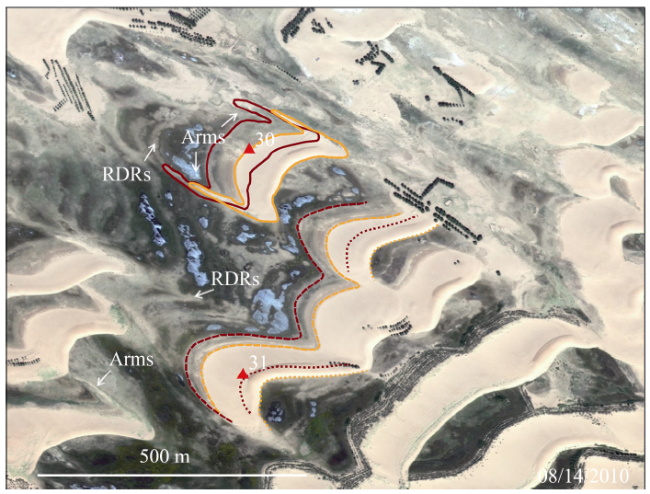
Figure 1 Example of dune morphodynamics in the Mu Us dune field. Red triangles mark the dunes with ID labeled nearby. Yellow and red lines mark the positions of the dunes in 2010 and in 2002 respectively. The dunes were partially fixed by vegetation, but still migrating toward the southeast (lower right). Sands from the stoss toe and dune horns were stabilized in-situ, forming residual dune ridges (RDRs) and upwind trailing arms (Arms), while a major part of the dunes kept migrating forward. North is toward top. Image source: GoogleTM Earth. See Xu et al. (2015b) for site coordinates and more examples illustrating crescentic dune migration and stabilization.

2.2 A simplified sand preservation model

A simplified sand preservation model was proposed based on the above observations, to predict the burial age of dune sands. When barchans or transverse ridge dunes migrate, sand is entrained by the wind from the stoss face and deposited on the lee face. Similarly, the dunes in the model have a simplified inner structure and migrate from left to right (Figure 2). Cross-bedding can form when the sands eroded along the gentle stoss slope avalanche down the lee slope.
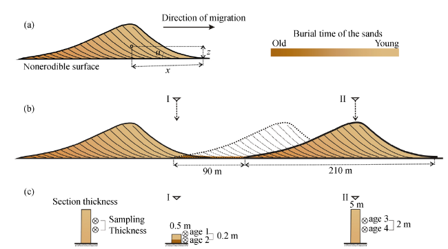
Figure 2 A simplified sand preservation model. Tan to brown colors indicate the time since burial (≈OSL age) of the sand, from short (light) to long (dark). Crescentic dunes migrate from left to right, maintaining constant morphology. In this model, we assume simplified inner structure (cross-bedding) as indicated by solid lines, and we assume the dunes have a constant migration rate and angle of repose, which means that most sands are recycled rather than contributing to in-situ accumulation. a: The age of the sands inside a dune is determined by the horizontal distance of the sand grains from the lee face toe (x), the vertical distance from the bottom surface (z), and angle of repose (α). b: The right-side dune is migrating from its former position (dotted line), leaving a small portion of sand in the interdune (thin darker colored wedge near position I). These residual sands were actually deposited when the right-side dune was near the current position of the left-side dune, before it reached the position indicated by dotted line. c: Simulated sampling sections. Sections I and II are simulated to be sampled from the interdune (position I) and the thickest part of the right-side dune (position II) as shown in b. For more details, see the main text, section 2.2.
The OSL age of dune sand is determined based on two assumptions. The first assumption is that most sand grains are thoroughly exposed to light during the transportation (Aitken, 1998). After a few hours of sunlight bleaching, their OSL signal should approach zero (Huntley and Clague, 1996). Therefore, the OSL ages of sand grains in a mobile dune are reset each time they are exposed on the stoss face, entrained by the wind, and re-deposited on the lee face. Supporting these assumptions, the OSL signals of sands on migratory dunes’ subaerial surfaces are close to background (Stokes, 1997). Thus, the OSL age of sand grains within a dune indicate the time since they were deposited on the lee face and buried by subsequent sand accumulation as the dune migrates. Assuming a constant dune migration rate and lee face angle of repose, the OSL ages of sand grains within an active dune are predictable from their burial depth and distance from the lee face toe (Figure 2a). If the time (in yr before the present) when a dune arrived at its current position is defined as T0, then the time since burial of sand grains at a specific location (x, z) within the dune (T(x, z)) is given by:
T(x, z) = (x-z/tanα)/rdune +T0 (1)
where rdune is migration rate, x is the horizontal distance of the sand grains from the lee face toe, z is the vertical distance from the bottom surface, and α is constant angle of repose. T(x, z) is the expected OSL age of sand grains from that location (x, z), if they were thoroughly bleached just before deposition and have not been disturbed since then.
The second assumption is that although most sand grains from the stoss face are remobilized and carried farther downwind as a dune migrates, there is often a small portion of sand near the base of the dune that is not re-entrained by the wind and is left behind by a migrating dune (i.e., net accumulation is slightly > 0, though accumulation may only be in patches). As shown in Figure 2b, when the right-side dune migrates, a small portion of sand is left in the interdune and will soon be buried by the advancing upwind dune. Reasons why this minor fraction of the sand may be trapped in this way in a real dune field include the presence of
moisture or vegetation in interdunes, which is often observed (e.g. Figure 1, Levin et al., 2009; Xu et al., 2015b), though its presence is probably sensitive to climate change. Residual sand ridges left behind by migrating dunes are direct evidence for this phenomenon. These buried residual sands should yield OSL ages corresponding to the time since they were originally deposited on a dune, assuming no later reworking or disturbance. In Figure 2, residual sands were deposited on the lee face of the right-side dune, before it migrated to its current position. The sand layer is thin, and the age is determined by the horizontal distance from the lee face toe of the right-side dune, assuming a consistent migration rate and angle of repose. These residual sands at position I in Figure 2b would have an older age than sands now being deposited on top of them, at the lee toe of the advancing left-side dune. Their age difference between the residual and newly deposited sand at this point is defined as ΔT, which equals the time required for the right-side dune to migrate to its present position, from where the left-side dune is now. ΔT is a characteristic value determined by both dune length (Ldune) and dune spacing (Dspacing):
ΔT = (Ldune + Dspacing) / rdune = Ldune / rdune + Dspacing / rdune (2)
Ldune/rdune is known as dune turn-over time (Tturn-over), which is defined by the time taken by the dune to travel its own length (Andreotti et al., 2002). The age difference between the sands from the stoss face and lee face toes of the same dune equals Tturn-over, if we assume complete bleaching of the sands during transportation and a simplified inner dune structure of the dune dominated by cross-beds produced by avalanching.

2.3 OSL dating

Two new sections (HK and MU49) were sampled from the Mu Us dune field, and their ages were determined using coarse quartz particles by the single aliquot regenerative-dose (SAR) OSL protocol, which has been widely applied to date aeolian deposits (Murray and Wintle, 2000). First, the sediments (unexposed to light) were treated with 10% HCl and 30% H2O2 to remove carbonate and organic matter, and then etched by 40% HF for 40 minutes to remove feldspar grains and re-sieved. Purified quartz grains (90-150 μm) were extracted and mounted on 10 mm diameter steel discs with silicon oil. Luminescence signals were measured on a Risø TL/OSL-DA-20C/D reader fitted with blue-green diodes (λ = 470±30 nm) and IR-LEDs emitting at 880±80 nm, to measure equivalent dose rate (Bøtter-Jensen et al., 2003). For estimating dose rate to grains, concentrations of U, Th and K were measured by Neutron Activation Analysis. Using the revised dose rate conversion factors and water content attenuation factor, the elemental concentration was converted into effective dose rate (Aitken, 1998). The calculation was performed using the ‘AGE’ program of Grün (2009), which includes a calculation of the cosmic ray contribution to the dose rate. In this study, seven sections including previously reported ones were analyzed to compare our simplified sand preservation model with actual dune field stratigraphy.

3 Modern observation of dune morphodynamics in the Mu Us dune field

3.1 Observational evidence from high-resolution satellite images

The Mu Us dune field is a typical semi-arid dune field where fully active dunes coexist with partially or fully stabilized dunes. Active dunes are mostly barchans and transverse dunes, and migrate to the southeast, consistent with the predominant strong wind direction. Meanwhile, some dunes are being stabilized by vegetation and their morphologies are often transformed to parabolic forms in the process (Xu et al., 2015b).
Vegetation colonizes barchan horns and expands from the lower part of stoss face to the higher part, to stabilize the barchans and transverse dunes in the study area (Figure 1). Residual dune ridges (RDRs) and long upwind trailing arms (Arms) were formed by vegetation colonization from lower stoss faces and barchan horns. These residual sands were stabilized in-situ, while major part of the dunes remained active and kept migrating toward the southeast. This process is common in active dune fields with wet and vegetated interdunes (Levin et al., 2009; Xu et al., 2015b). Generally, these residual sands are thin. If environmental conditions in the interdune favor vegetation growth and both sand deposition and erosion are negligible, weak soil could develop on these sands even though they usually are soon buried by the advancing upwind dune, and preserved in sedimentary sequences as paleo-dune deposits.
Moreover, some dunes including large transverse dunes were fully stabilized within ten years in the Mu Us dune field by either natural or artificially planted vegetation (Xu et al., 2015b), an extreme case, but one which could possibly have occurred with very rapid climate change in the past. At current rates, vegetation expansion could probably lead to stabilization of most dunes within a few hundred years.

3.2 Rate of migration and dune turn-over time

Migration rates of bare dunes and less vegetated dunes in the Mu Us dune field show a clear power-law relationship with their initial lee face lengths (Figure 3). Barchans and transverse dunes migrate slower when they become larger. Larger dunes with lee faces longer than 25 m have migration rates of 2-3 m per year, while migration rates of smaller dunes are reduced dramatically by increasing vegetation cover. Those dunes with the greatest vegetation cover migrate the slowest, and will probably be stabilized soon.
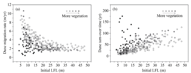
Figure 3 Dune migration rate (a) and dune turn-over time (b) in the Mu Us dune field. Initial length of dune lee face (LFL) was measured from the historical images. Grayness of the dots indicates the portion of vegetation cover on the dunes. White dots represent bare dunes.
Dune turn-over time calculated from dune length and migration rate indicates the time taken by one cycle of dune displacement. In the Mu Us dune field, most dunes have small to intermediate sizes (height of 2-20 m), with an average migration rate of 3.0±1.7 m/yr. Thus, most active dunes can be completely turned over at the current rate in less than 100 years (Figure 3). Dunes with larger sizes have longer turn-over time, but even the largest active dunes in this dune field would be completely turned over in <200 yr at current migration rates. Dunes with greater vegetation cover theoretically have longer turn-over time due to reduced migration rate, but given the current trend toward stabilization, they will likely become inactive before turning over again. A stratigraphic section exposing the interior of one of these dormant dunes could yield OSL ages within a narrow range, within about one turn-over time from the age of final stabilization.

4 Results from the simplified sand preservation model

4.1 The burial age of the sands

Quantitative data from the modern observations described above were applied in the simplified sand preservation model to predict the burial age of the sands in dunes like those characterizing the Mu Us region today (Figure 2). Using the modern average migration rate of ~3 m/yr, dune length of 210 m and dune spacing of 90 m, the turn-over time of an average-sized dune is ~70 yr and ΔT is about 100 yr. Using 34° as the angle of repose (α), the sand deposition rate on lee face (rsand) would be ~2 m/yr.
Based on the model, the burial age difference between the sands on the lee face and stoss face toes of the same dune equals its turn-over time, ~70 yr on average. Residual sands sampled from the lower layer of section I in Figure 2 would be ~100 yr older than the sands from lee face toe of the right-side dune, and ~30 yr older than sands on its stoss face toe.

4.2 Simulated depth-age profiles

A case was simulated, starting at a time T1 which is 8100 yr ago, in which the dune now on the right side migrated from the left-side dune’s position at time T0. Based on ΔT, T0 would be 8000 yr ago. After T0, the dunes became stabilized by vegetation and soil formed on dunes and interdunes. To simplify the simulation, the thickness of residual sand that is left in the interdune as one migrating dune passes is set as 25 centimeter. While in many cases, slow aeolian deposition of dust or sand may continue even on largely stable dune fields, we assume no deposition after T0. Depth-age profiles of sections I and II were then simulated by the model (Figure 4).
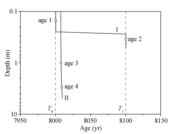
Figure 4 Modeled depth-age profiles. Red and blue lines represent sampling sections I and II, respectively, as shown in Figure 2. Ages 1 to 4 are simulated burial ages of the sands. T1 indicates the time when right-side dune was at the position of left-side dune, and T0 indicates the time when the dune arrived at its present location.
The burial ages of the sands from section II (Age 3 and Age 4) are similar, and both are close to T0. But the thin lower layer in section I has the oldest burial age (Age 2), close to T1. Its upper layer has an age (Age 1) close to T0. These two layers from section I represent sand deposition during two cycles of turn-over, and the difference between their ages is about 100 yr, approximately equal to ΔT. Thick sands from section II record only the last cycle of dune turn-over.

5 Dune stratigraphic sequences in the Mu Us dune field

5.1 Newly investigated dune stratigraphic sequences

Late Quaternary dune stratigraphies in the study area are characterized by aeolian sands with no evidence of soil development, alternating with paleosols. Sand deposition is related to migration of active dunes, while the paleosols form during periods of low sand mobility under vegetation cover, with largely stable dunes. The paleosols could have developed beneath a stable land surface, in sands deposited entirely in the preceding period of dune activity; however, the thick A horizons and relatively fine particle size of many of the paleosols in the study area suggests that some dust and sand continues to accumulate at low rates as they develop. Two sections (Figure 5 and Table 1) were sampled from different geomorphological positions. Section HK is above the level of modern interdunes and has a thick aeolian sand layer with a dark paleosol developed at the top. The thin sand layer of MU49 was sampled from the interdune and has dark paleosol at the top as well. The OSL ages from these sections suggest the two paleosols formed after 8 ka, with soil development at HK continuing until at least 5 ka, consistent with previous conclusions that most dunes in the Mu Us dune field were stabilized during the mid-Holocene (Lu et al., 2013; Xu et al., 2013).
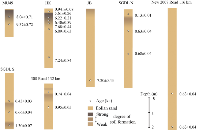
Figure 5 Newly investigated dune sections (MU49 and HK) in the Mu Us dune field, and typical dune sections from our previous studies. Color columns illustrate alternation of sand and paleosol. OSL ages (ka; circles) are shown aside each column. Thick sand layers in HK, JB, SGDL N and New 2007 Road 116 km sections indicate sand deposition that was almost instantaneous (rate too high to be resolved by OSL dating), interpreted as deposition within a migrating dune, much of which is preserved. Thick sands from HK and JB sections were dated around 7 ka, and the paleosol in HK was formed after sand deposition. Thick sands in SGDL N and New 2007 Road 116 km sections were deposited around 0.63 ka. Sands dated in the 308 Road 132 km and SGDL S sections are separated by weak paleosols, and their age difference is about 200 years, approximately equal to ΔT for typical dune sizes in this region. They are regarded as residual sands left behind by migrating dunes and representing a small fraction of original dune height. JB section was from the Mu Us dune field, reported by Zhou et al. (2005). SGDL N, New 2007 Road 116 km, 308 Road 132 km and SGDL S sections were from the Otindag dune field, according to Zhou et al. (2008).
Table 1 Newly obtained OSL ages
Sample Burial
depth (m)
Water
content (%)
K (%) U
(ppm)
Th
(ppm)
De
(Gy)
Dose rate
(Gy/ka)
Aliquots
Num.
Age
(ka)
MU49-40 0.40 2.42 1.70 0.86 4.49 18.54±0.85 2.31±0.18 12 8.04±0.71
MU49-80 0.80 0.77 1.50 0.68 2.87 18.62±0.49 1.99±0.14 19 9.37±0.72
HK-0.15 m 0.15 1.5 2.84 1.04 3.63 2.76±0.22 3.02±0.10 33 0.91±0.08
HK-0.4 m 0.40 5.2 2.67 1.2 4.64 16.08±0.11 2.87±0.10 46 5.61±0.26
HK-0.6 m 0.60 5.4 2.63 1 4.16 17.07±0.26 2.74±0.10 59 6.22±0.31
HK-0.8 m 0.80 5.7 2.78 1.09 4.04 18.28±0.71 2.86±0.10 18 6.40±0.39
HK-1 m 1.00 5.5 2.69 1.1 4.68 21.77±0.73 2.84±0.10 43 7.68±0.44
HK-1.4 m 1.40 3.8 2.76 0.91 3.39 19.31±1.51 2.80±0.10 27 6.89±0.63
HK-3.3 m 3.30 2 2.78 0.79 2.89 20.09±2.15 2.78±0.10 10 7.24±0.84

5.2 Instantaneously deposited thick sands

Two ages from thick sands in the HK section are about 7 ka, within the major period of widespread stabilization of the dune field. We interpret the thick sand unit as representing much or all of the original height of a paleo-dune, that is, a vertical section similar to that represented by section II in the simplified model (Figure 2). Sands from section II were almost instantaneously deposited during one cycle of turn-over, and have similar ages (Figure 4). It is inferred that thick sands from the HK section with similar ages (possibly identical given error estimates) were probably deposited during one cycle of turn-over as well. This age is close to the age of upper paleosol, suggesting that the soil began to develop on the stabilized dune soon after the deposition of the thick sands. Modern observations demonstrates that some dunes including large transverse dunes can be fully stabilized within ten years in the Mu Us dune field, thus rapid stabilization is possible at the HK location.
Thick, almost instantaneously deposited sands were also identified in the JB section (Zhou et al., 2005), SGDL N and New 2007 Road 116 km sections from the Otindag dune field that is located east to the Mu Us dune field (Zhou et al., 2008), and in both late Pleistocene and late Holocene dune sections in Nebraska dune fields (Mason et al., 2011). In each case, thick sands from the same depositional unit have almost identical ages, which are also similar to ages obtained within the paleosol at the top of that unit, indicating that the stabilization occurred just after the accumulation of the sands. Like HK, the age of thick sands in the JB section was within the main period of stabilization of the Mu Us dune field. The thick sands in SGDL N and New 2007 Road 116 km sections were accumulated during 0.63-0.68 ka, within a short interval of stabilization in the Otindag dune field (Zhou et al., 2008).
Post-depositional mixing such as bioturbation could result in homogenisation of the sediments and reset the OSL signal (Bateman et al., 2007; Gliganic et al., 2016). In this case, the disturbed sands would have a younger age that is close to the time of bioturbation. Since bioturbation should be most active beneath a stable, vegetated land surface, the age of the bioturbated sands would likely indicate a period of dune stabilization. However, insect or mammal burrows, root traces, and other evidence of bioturbation are not common in thick sand units of the Mu Us and Otindag dune fields, and aeolian sedimentary structures are often preserved. In addition, sections like JB and New 2007 Road 116 km have such thick sand units that their deeper parts are probably not affected by bioturbation (Hanson et al., 2015).

5.3 Residual sands

Thin sand layers are also common in dune stratigraphies, such as the MU49, 308 Road 132 km and SGDL S sections (Figure 5), and some of them can be regarded as stacks of thin residual sand beds based on their geomorphological positions. Residual sands buried in the interdunes (section I in Figure 2) indicate preservation of only a small part of the dune sand initially deposited there as each dune passes (and some dunes may leave no residual sand behind at all). Multiple residual sand beds can be superimposed at some certain locations where net sand accumulation and preservation are favorable. In such a setting, identification of individual depositional units based on field observations of sedimentary facies or structures can be difficult, because the sand units are often homogenous. Even when it is possible to identify bounding surfaces separating stratigraphic units with similar sedimentary properties, they are not always associated with significant hiatuses in sand accumulation (Leighton et al., 2013). In the Mu Us and Otindag dune fields, weak soils can develop on thin residual sands if the interdune becomes wet or vegetated. Thus, residual sands that are deposited during the passage of successive migrating dunes could be bounded by weakly developed paleosols. Based on the simplified model (Figure 2), the minimal age difference between two layers of residual sands would equal ΔT. Indeed, the age difference of thin sand layers beneath and above the paleosol in 308 Road 132 km and SGDL S sections (Figure 5) was 100-200 years, approximately equal to ΔT for typical dunes in these fields and probably enough time for organic matter accumulation to be evident in a weak soil. Thus, the units above and below the paleosols in these sections could simply record migration of two dunes over the sampling site. Section MU49 (Figure 5) is more difficult to interpret, but it could also represent two residual layers, with the large gap between the age of the paleosol and the age in the sand below it representing incomplete preservation in this setting.

6 Reinterpretation of paleo-dune deposits as paleoenvironmental records

6.1 The preservation of paleo-dune deposits and paleoenvironmental implications of their OSL ages

Both deposition and wind erosion are widespread and rapid processes that shape the landscape of a dune field. The preservation of aeolian sands is strongly influenced by morphodynamics of the dunes that are closely related to dune size, morphology, wind and vegetation, etc. In the Mu Us dune field, the main body of a crescentic dune is mostly active and migrating forward, with only a small part of the lower stoss face and dune horns possibly left behind as residual sands (Figure 1). Based on the simplified sand preservation model (Figure 2), the OSL age of sand within a migrating dune is reset each time it is turned over and cannot exceed the dune turn-over time.
At current migration rates, most active dunes in the Mu Us dune field can be completely turned over in less than 100 years (Figure 3). Therefore, a maximum age of 100 yr is obtained for active dunes. On one hand, the relatively short turn-over time of 10-100 yrs implies that the response of dune morphological processes to perturbations may be quick, and thus can be recorded by dune chronostratigraphies (Wolfe and Hugenholtz, 2009). On the other hand, considering that the precision of luminescence ages is limited to around 5% (Telfer and Hesse, 2013), if the dune was older than 200-2000 yrs, the sands that are deposited in one cycle of turn-over would have indistinguishable ages. Indeed, similar OSL ages are acquired from multiple depths in the thick sands in Figure 5 that are interpreted as largely preserved paleo-dunes. If this interpretation is correct, the true age of these OSL samples should fall within 10-100 yr (one turnover time) before the time these paleo-dunes were stabilized, and scatter in the ages that exceeds that time span is due to error in dating.
At present, the crescentic dunes in the Mu Us dune field are relatively small, with high mobility. If we assume the dunes had similar morphology during the past period of intensive activity, the dunes could hardly be preserved. Instead, they were possibly migrating continuously, in the process continually resetting the OSL age of sand within them. Indeed, aeolian sands dating to the LGM have rarely been reported within this dune field, though other evidence indicates the field was extensively active and expanded in area at that time (Xu et al., 2015a). By contrast, well-preserved thick sands in the HK and JB sections are dated to the early-mid Holocene (Figure 5). Based on the interpretation above, however, the preservation of these thick sands is directly related to widespread stabilization of the Mu Us dune field at this time, as recorded by the extensive mid-Holocene paleosol. In fact, these sections are valuable as records of the exact timing of local stabilization. Similarly, the SGDL N section preserves much of the thickness of a dune and records the time when the dune stabilized in the late Holocene, followed by soil development. The preservation of these thick sands at some sites indicates that later episodes of dune activation did not mobilize all of the aeolian sand within the dune field.
Residual sands that are left trapped in an interdune as the dune they were deposited in migrated away might have more chance to be buried by subsequent sand deposition and preserved over the long term (Figure 1), because of their landscape setting within the dune field. More importantly, though they are often thin and contain only a small volume of sand, these residual beds record past cycles of dune turn-over that may span a long episode of dune activity. Residual sands could be superimposed to form what appears to be a single thick sand unit, but OSL ages from this unit should span a much larger length of time than thick sands deposited within a single dune. Based on the average ΔT in the Mu Us dune field, the age difference between two superimposed residual beds would be at least ~100 yrs. Indeed, two layers of residual sands separated by weak paleosols in 308 Road 132 km and SGDL S sections differ in age by approximately that ΔT (Figure 5).

6.2 Paleoenvironmental implications of the OSL age distribution over time

A summary of >200 OSL ages dated between 25-6 ka from the four largest dune fields with similar environmental conditions in northern China (including the Mu Us, Otindag, Horqin, and Hulun Buir dune fields) is shown in Figure 6. The frequency of sand ages during the Last Glacial Maximum (LGM, 26-15 ka) is low. It has been proposed that the scarcity of preserved LGM sand, not only in the northern Chinese dune fields but also in other mid-latitude dune fields is a result of intensive aeolian activity without substantial net sand accumulation (Xu et al., 2015a). For example, much of the Mu Us dune field in the LGM could have been characterized by small, widely spaced barchan dunes moving rapidly. Virtually all sand in the dunes would have been continually recycled during migration, with preservation only in locations such as periglacial wedges or the south/ southeast margin of the dune field where sand was buried by loess. Due to a dune field state of net erosion, sand deposited at that time is hardly preserved within the central dune field. Rare sand deposition and low frequency of sand ages are also observed after 8 ka, but in this case widespread paleosol development (Figure 6) demonstrates that this is because of a major interval of dune field stabilization, not poor preservation (Lu et al., 2013; Xu et al., 2013).
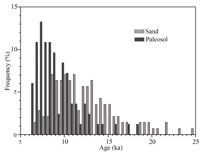
Figure 6 Histogram showing frequency distribution of OSL ages of aeolian sands and paleosols over time (25-6 ka, n>200) in dune fields of northern China
Therefore, a time period marked by few ages indicating sand deposition may actually be an interval of widespread aeolian activity but poor preservation, because of an erosional phase of the aeolian system (Figure 7). This may result from low or moderate sand supply, high sand availability, and/or high transport capacity (Xu et al., 2015a). The alternative interpretation of low age frequency as indicative of dune field stabilization can be confirmed when there is evidence of widespread paleosol development. Thus, the field stratigraphic evidence is the key to choosing between these interpretations of large OSL datasets from dune fields.
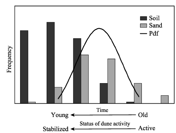
Figure 7 Paleoenvironmental implications of the frequency distribution of OSL ages
The interpretation of clusters of OSL ages from aeolian sands with no evidence of soil development is more complicated. Previous interpretation often interpreted clusters as indicating periods of major or sustained dune activity. However, rapid turn-over times in the Mu Us dune field today would suggest that the age clusters might reflect the time of dune field stabilization, because the main period of dune activity preceding the age cluster is not represented by OSL dating due to continual recycling of the sands. The latter interpretation was proposed for the age clusters in a field of migrating dunes in South Africa (Chase and Thomas, 2006). It should be noted that turn-over time can be much longer, possibly thousands of years, for very large barchanoid ridge and megabarchan dunes such as those in the Nebraska Sand Hills (Mason et al., 2011). In that case, the last several thousand years of a long period of sustained activity would likely be represented by OSL ages even if the dune sand is completely recycled, and ages from the upwind part of a large dune might predate the stabilization of the dune by hundreds to thousands of years. Thus, the cluster of late Pleistocene OSL ages from large dunes of the Nebraska Sand Hills is interpreted as representing part of a sustained interval of activity (Mason et al., 2011).
In regard to the OSL ages from the northern Chinese dune fields shown in Figure 6, we argue that the age cluster or the increase in the frequency of sand ages between 15-10 ka should at least represent a shift to conditions that favored more sand accumulation, in comparison with the preceding period of widespread activity but poor preservation that is marked by few ages. Changes in sand accumulation and preservation are related to change in major controls on the aeolian system (Xu et al., 2015a): a) sediment supply, the abundance of source material for the system, b) the transport capacity of the wind, and c) sediment availability, which is the susceptibility of aeolian sediment to transport under specific set of environmental conditions including vegetation cover, moisture, etc. (Kocurek and Lancaster, 1999). Any changes in environmental conditions that affect these factors would influence sand preservation and the frequency distribution of sand ages. For example, the concept of near-complete recycling of sand over short timescales may be possible for the case of rapidly migrating, widely spaced small dunes, as suggested for the Mu Us dune field in the LGM. However, where sand supply is larger and dunes are more closely spaced, the basal parts of some dunes might not be completely eroded but would be buried by the next upwind dune. That is, there could be at least minor, patchy, net accumulation of sand. A recent modeling study has revealed increased sand accumulation and greater preservation caused by greater sediment supply (Leighton et al., 2014b).
In the Mu Us dune field, environmental changes that probably caused transformation of the dune field state from net erosion to net accumulation after 15 ka include reduced wind strength, regional permafrost degradation, etc. (Xu et al., 2015a). Importantly, the sands from the deglacial period (15-10 ka) typically found in the Mu Us and other dune fields of northern China are mostly preserved in thin beds, and are much less than the full height of even a small dune, consistent with the mechanism of preservation proposed by this study (Figure 2). This kind of preservation could also be favored by a shift to environmental conditions such as a shallow water table, patches of vegetation in lower, moister locations, or greater moisture in unsaturated sands (Bateman and Murton, 2006).
Indeed, the cluster of sand ages around 10 ka centers right before and partly overlapping with a major period of paleosol formation (Figure 6). The early occurrence of paleosols after about 15 ka might suggest a climate shift into moderate conditions, such as reduced wind strength or greater moisture availability that facilitates vegetation growth (Xu et al., 2015a). The interdunes may initially have become vegetated due to wetter climate (Xu et al., 2015b), favoring local stabilization and the formation of residual sands or dune ridges in the interdunes (Figure 1). However, the majority of dunes were likely still active, and considering their relatively short turn-over time, OSL ages from 15 ka to 10 ka probably record sand deposition within these dunes, with some of the sand then preserved as thin residual beds that were sampled for dating. Based on evidence obtained so far, the major internal part of the Mu Us dune field and other dune fields of northern China remained largely mobile during the deglaciation as they were in the LGM. Thus, the age cluster at 15-10 ka is correctly interpreted as representing the later part of an interval of widespread dune activity, as previously assumed (Mason et al., 2009; Lu et al., 2011).
To conclude, as shown in Figure 7, a peak of sand age frequency likely represents changes in environmental conditions that favor more sand preservation, or a shift in dune field activity towards stabilization rather than a peak of active dune extent, especially if it partially overlaps with an independently identified interval of stabilization (e.g. one recorded by paleosols). The nature and magnitude of these biases in the distribution of sand ages over time are strongly affected by the magnitude of net sand accumulation, which is in turn related to sand supply, transport capacity and sand availability, and ultimately climate change.

7 Conclusions

On the basis of a case study from the Mu Us dune field, this study re-examined the paleoenvironmental significance of paleo-dune deposits and their OSL ages. Observational evidence indicate that relatively small crescentic dunes from the Mu Us dune field can be turned over or stabilized in relatively short time periods (10s to 100s of years). The analysis of a sand preservation model emphasizes that dune chronologies are affected by sand accumulation and the preservation potential of aeolian sands which are sensitive to climate change. Thick, almost instantaneously deposited sands signal dune stabilization, near the very end of a dune activity episode. Thin layers of residual sands in the interdune represent sediment deposited within a dune, which subsequently migrated downwind. Periods with low frequency of sand OSL ages may actually have been times of intensive aeolian activity because of continually recycling during dune migration with rare sand preservation. High frequency of sand ages does not indicate intensive activity per se, but instead generally implies a dune field state that favors significant net sand accumulation in locations where it has high preservation potential. Therefore, the sand age cluster likely represents a shift in dune field activity towards stabilization, not a peak of active dune extent, especially if it partially overlaps with an independently identified interval of stabilization (e.g. one recorded by paleosols). While this study focuses on crescentic dunes, it emphasizes the broader importance of geomorphic process analysis in Quaternary and paleoenvironmental studies.

The authors have declared that no competing interests exist.

[1]
Aitken M J, 1998. An Introduction to Optical Dating. Oxford: Oxford University Press, 7-47.

[2]
Andreotti B, Claudin P, Douady S, 2002. Selection of dune shapes and velocities (Part 1): Dynamics of sand, wind and barchans.The European Physical Journal B-Condensed Matter and Complex Systems, 28: 321-339.Almost fifty years of investigations of barchan dunes morphology and dynamics is reviewed, with emphasis on the physical understanding of these objects. The characteristic quantities measured on the field (shape, size, velocity) and the physical problems they rise are presented. Then, we review the dynamical mechanisms explaining the formation and the propagation of dunes. In particular a complete and original approach of the sand transport over a flat sand bed is proposed and discussed. We conclude on open problems by outlining future research directions.

DOI

[3]
Bailey R M, Thomas D S G, 2014. A quantitative approach to understanding dated dune stratigraphies.Earth Surface Processes and Landforms, 39(5): 614-631.Attempts to reconstruct past changes in climate-related forcing of dryland landscapes are hampered by the lack of an adequate quantitative framework for understanding the production and interpretation of dated sedimentary records. In drylands, as in other environments, information on past forcing conditions is progressively modified, degraded and removed from the available stratigraphic record by a series of ‘filters’ involving changes in the primary forcing factors themselves, geomorphological processes and the sampling/dating procedures. In this paper we describe a quantitative model that includes these effects, and use the model to examine the nature of preserved dryland sedimentary records and their relationships to primary forcing conditions: thicker preserved sedimentary records reflect periods of more intense aeolian activity; localized switching between erosion and deposition results in discontinuous and highly variable stratigraphic sequences; a preservation bias towards younger deposits is observed, potentially leading to a continuum of accumulation that decays approximately in proportion to . Time periods not represented by deposition can in some cases be interpreted as periods of higher precipitation and/or lower wind energy. An asymmetry exists between the efficiency with which past ‘drier’ and ‘wetter’ episodes can be identified, which relates to the time-separation of depositional periods and the correct distinction between hiatuses due to forcing conditions and those due to under-sampling. Relevant to this is the effect of random dating errors (statistical uncertainty), which (increasingly with age) filter-out higher frequency events from the record. A new data treatment method (termed Accumulation Rate Variability) provides an efficient proxy for accumulation rates, and therefore the intensity of aeolian activity, with significant improvements over existing date–frequency methods. The filtering problem discussed applies to all attempts at understanding the timing and nature of past events, independent of the proxies and dating methods employed. Further explicit analysis of these issues would be beneficial. Copyright 08 2013 John Wiley & Sons, Ltd.

DOI

[4]
Bateman M D, Boulter C H, Carr A Set al., 2007. Preserving the palaeoenvironmental record in drylands: Bioturbation and its significance for luminescence-derived chronologies.Sedimentary Geology, 195: 5-19.Luminescence (OSL) dating has revolutionised the understanding of Late Pleistocene dryland activity. However, one of the key assumptions for this sort of palaeoenvironmental work is that sedimentary sequences have been preserved intact , enabling their use as proxy indicators of past changes. This relies on stabilisation or burial soon after deposition and a mechanism to prevent any subsequent re-mobilisation. As well as a dating technique OSL, especially at the single grain level, can be used to gain an insight into post-depositional processes that may distort or invalidate the palaeoenvironmental record of geological sediment sequences. This paper explores the possible impact of bioturbation (the movement of sediment by flora and fauna) on luminescence-derived chronologies from Quaternary sedimentary deposits in Texas and Florida (USA) which have both independent radiocarbon chronologies and archaeological evidence. These sites clearly illustrate the ability of bioturbation to rejuvenate ancient weathered sandy bedrock and/or to alter depositional stratigraphies through the processes of exhumation and sub-surface mixing of sediment. The use of multiple OSL replicate measurements is advocated as a strategy for checking for bioturbated sediment. Where significant OSL heterogeneity is found, caution should be taken with the derived OSL ages and further measurements at the single grain level are recommended. Observations from the linear dunes of the Kalahari show them to have no bedding structure and to have OSL heterogeneity similar to that shown from the bioturbated Texan and Florida sites. The Kalahari linear dunes could therefore have undergone hitherto undetected post-depositional sediment disturbance which would have implications for the established OSL chronology for the region.

DOI

[5]
Bateman M D, Murton J B, 2006. The chronostratigraphy of Late Pleistocene glacial and periglacial aeolian activity in the Tuktoyaktuk Coastlands, NWT, Canada.Quaternary Science Reviews, 25: 2552-2568.Aeolian periglacial sand deposits are common in the Tuktoyaktuk Coastlands of Western Arctic Canada. Regionally extensive and thick aeolian sand-sheet deposits have been observed in two major stratigraphic settings: within a sand unit characterized by large aeolian dune deposits; and interbedded with glaciofluvial outwash from the Laurentide Ice Sheet (LIS). Small, localized sand sheets have also been observed along the tops of sandy bluffs, within sequences of drained thermokarst lakes deposits and as an involuted veneer above buried basal ice of the LIS. On the basis of radiocarbon and optically stimulated luminescence (OSL) dates from preserved periglacial aeolian sand sheets and dunes a regional chronostratigraphy is presented which indicates that both extensive dunes and sand sheets accumulated mainly between ca 30 and 13 ka. A switch to dominantly sand-sheet aggradation at ca 14 13 ka, with sand sheets forming widely until ca 8 ka, is attributed to (a) surface armouring by glacial deposits associated with the advance of the LIS; and (b) amelioration of the climate from cold aridity. An absence of OSL dates between ca 8 and 1 ka suggests that sand sheets stabilized during much of the Holocene. Local sand-sheet aggradation during recent centuries has occurred near sandy bluffs and on the floors of drained thermokarst lakes. The OSL dates constrain the maximum extent of the LIS in the Tuktoyaktuk Coastlands to Marine Isotope Stage 2.

DOI

[6]
Bøtter-Jensen L, Andersen C E, Duller G A Tet al., 2003, Developments in radiation, stimulation and observation facilities in luminescence measurements.Radiation Measurements, 37: 535-541.This paper summarises recent developments in the Ris TL/OSL reader. These new developments include an elevated temperature irradiation facility that has been expanded to measure variable temperature radioluminescence (RL) during beta irradiation. This RL facility allows the measurement of TL, OSL and RL in the same software-controlled automatic sequence. To provide an alternative to the ja:math beta source, the performance of a software-controlled mini X-ray generator has been investigated. This has the advantage of providing a range of dose rates spanning more than three orders of magnitude up to more than ja:math . A separate bleaching facility has also been added to the reader, new powerful infrared (IR) light-emitting diodes have replaced the IR laser diode in the general OSL unit, and an IR laser has been included in the single-grain OSL attachment. This paper describes these new facilities, and illustrates their applications with representative measurements.

DOI

[7]
Burrough S L, Thomas D S G, 2013. Central southern Africa at the time of the African Humid Period: A new analysis of Holocene palaeoenvironmental and palaeoclimate data.Quaternary Science Reviews, 80: 29-46.The Holocene African Humid Period (c 14.8-5.5 ka) is now recognised in high-resolution records from western Africa as well as in tropical Africa north of the equator. Establishing a clear picture of Late Quaternary, including Holocene, environmental changes in central southern Africa is proving both difficult and contentious. This is because in dryland systems in particular it can be difficult to distinguish the effects of sub-millennial scale regional climatic variability from those of major externally-forced global climate changes, and because it is essential to distinguish records of environmental drivers from those of environmental responses. We analyse and review existing records for central southern Africa, and neighbouring areas affected by the same climate systems, to understand the primary controls of regional hydrological systems during the Holocene. We then present new data from Makgadikgadi basin barchan dunes that indicate mid-late Holocene aridity following a period of marked hydrological dynamism extending from the early Holocene. We suggest that present-day conditions in central southern Africa are relatively stable compared to the early and mid-Holocene and infer that this period of relative stability in the landscape has occurred since ca 2 ka. We explain Holocene hydrological changes through analysis of changing zonal climatic influences linked to Congo Air Boundary (CAB) and Inter-tropical Convergence Zone (ITCZ) dynamics, the effects of which filter into the region via complex drainage basin dynamics. It is proposed that, sensu strict, the AHP was not a spatially uniform feature of early Holocene central southern Africa. (C) 2013 Elsevier Ltd. All rights reserved.

DOI

[8]
Chase B, 2009. Evaluating the use of dune sediments as a proxy for palaeo-aridity: A southern African case study.Earth-Science Reviews, 93: 31-45.The dominance of dryland environments in the Southern Hemisphere makes the study of these regions of critical importance for the development of regional, hemispheric and global models of environmental change. Unfortunately, the wetting and drying cycles associated with semi-hyperarid climates are not conducive to the preservation of traditional organic proxy data sources. The last decade, however, has seen the development of a number of alternative archives including the application of luminescence dating techniques to dunes and other aeolian deposits. In continental situations, the existence of relict dune fields has long been thought to be evidence of drier conditions during the Pleistocene, and direct ages from these features have been interpreted almost exclusively as indicating phases of aridity. However, an increasing number of ages from a broader range of environments are calling into question the assumption that aeolian activity can be simply equated with aridity. Presented here is a comparison of dune ages that have been obtained from across southern Africa with a range of proxies from both terrestrial and marine records. Taken as a whole, three primary phases of activity can be identified at ~0260–40, 35–20 and 17–4ka. The frequent discordance with other terrestrial records indicating coeval increases in humidity and the close correlation of these phases with wind strength proxies suggest that aridity is unlikely to be the sole, or even primary, forcing mechanism for aeolian activity in the region, and the palaeoclimatic significance of these sedimentary archives needs to be reassessed.

DOI

[9]
Chase B M, Thomas D S G, 2006. Late Quaternary dune accumulation along the western margin of South Africa: Distinguishing forcing mechanisms through the analysis of migratory dune forms.Earth Planetary Science Letters, 251: 318-333.The west coast of South Africa is situated at a critical location between temperate and subtropical oceanic and atmospheric circulation systems, and palaeoenvironmental proxies from this region have the potential to elucidate issues concerning variations within these systems over glacial–interglacical cycles. While semi-arid climates have hindered the preservations of organic proxies, a variety of aeolian bedforms have been analysed in an effort to improve our understanding of environmental change in the region. Optically stimulated luminescence measurements of 51 samples from 15 reticulate dune sites along the west coast have enabled the identification of phases of aeolian activity, as well as periods of relative geomorphic stability. Combined with data derived from previous studies of the region's sediment accumulating deposits and other palaeoenvironmental proxies, periods of increased windiness are identified at 16–24, 30–33, 43–49 and 63–73ka From approximately 17–12ka, decreasing transport capacity resulted in the stabilisation of the west coast's dune fields. During the Holocene Altithermal (65024–8ka), despite reduced wind strength, increased aridity resulting from higher temperatures and a reduced influence of moisture bearing westerly systems appears to have trigged widespread remobilisation of the region's dune fields. The combination of ages from a variety of dune forms with different development mechanisms, and comparisons with a range of proxy data sources, have allowed for an enhanced interpretation of the region's aeolian archives, moving beyond simple correlations between dune activity and “aridity.”

DOI

[10]
Dong G, 2002. Climate and Environment Changes in Deserts of China. Beijing: China Ocean Press, 734. (in Chinese)

[11]
Fan Y, Zhang F, Zhang Fet al., 2016. History and mechanisms for the expansion of the Badain Jaran Desert, northern China, since 20 ka: Geological and luminescence chronological evidence.Holocene, 26(4): 532-548.Desert landscapes are widely distributed in the arid northern China. The Badain Jaran Desert (BJD) is located north-west of the Tengger Desert (TD) and Ulan Buh Desert (UBD), with the Yabrai and Bayan Ulan Mountains separating the BJD from the TD and UBD. Many sand belts with an orientation of NW-SE, which is similar to that of the prevailing sand-transporting winds, connect the BJD with the TD and UBD, forming the sand transportation routes from the BJD to the TD and UBD. Thus, these sand belts are sensitive to the expansion or shrinkage of the BJD, whose chronologies could be critical for understanding the evolution of the BJD. However, age data are still very limited. In this study, field investigation and optically stimulated luminescence (OSL) dating have been conducted in 14 profiles, and 24 OSL ages are obtained. The OSL ages range from approximately 15 ka to modern. Our results and previous chronological data revealed that the BJD's expansion initiated at 20 ka, and the present-day landscape formed within the latest 2 ka with periodic expansions at 19-15, 11-9, 7.3 and 6-5 ka. We propose that these expansions of the BJD before similar to 5 ka and during the 0.9-0.8 ka interval were responses to regionally low effective moisture conditions in north-western China, while the expansions at similar to 2 ka and within the latest 200 years were likely triggered by intensified human activity.

DOI

[12]
Fitzsimmons K E, Cohen T J, Hesse P Pet al., 2013. Late Quaternary palaeoenvironmental change in the Australian drylands.Quaternary Science Reviews, 74: 78-96.The timing and extent of relatively arid and humid phases vary across the continent, in particular between the westerly wind-controlled temperate latitudes, and the interior and north which are influenced by tropically sourced precipitation. Relatively humid phases in the Murray-Darling Basin on the semi-arid margins, which were characterised by large rivers most likely fed by snow melt, prevailed from 40ka to the Last Glacial Maximum (LGM), and from the deglacial to the mid Holocene. By contrast, the Lake Eyre basin in central Australia remained relatively dry throughout the last 40ka, with lake high stands at Lake Frome around 35–30ka, and parts of the deglacial period and the mid-Holocene. The LGM was characterised by widespread relative aridity and colder conditions, as evidenced by extensive desert dune activity and dust transport, lake level fall, and reduced but episodic fluvial activity. The climate of the deglacial period was spatially divergent. The southern part of the continent experienced a brief humid phase around 6517–15ka, followed by increased dune activity around 6514–10ka. This contrasts with the post-LGM persistence of arid conditions in the north, associated with a lapsed monsoon and reflected in lake level lows and reduced fluvial activity, followed by intensification of the monsoon and increasingly effective precipitation from 6514ka. Palaeoenvironmental change during the Holocene was also spatially variable. The early to mid-Holocene was, however, generally characterised by moderately humid conditions, demonstrated by lake level rise, source-bordering dune activity, and speleothem growth, persisting at different times across the continent. Increasingly arid conditions developed into the late Holocene, particularly in the central arid zone.

DOI

[13]
Fitzsimmons K E, Rhodes E J, Magee J Wet al., 2007. The timing of linear dune activity in the Strzelecki and Tirari deserts.Quaternary Science Reviews, 26: 2598-2616.Linear dunes occupy more than one-third of the Australian continent, but the timing of their formation is poorly understood. In this study, we collected 82 samples from 26 sites across the Strzelecki and Tirari Deserts in the driest part of central Australia to provide an optically stimulated luminescence chronology for these dunefields. The dunes preserve up to four stratigraphic horizons, bounded by palaeosols, which represent evidence for multiple periods of reactivation punctuated by episodes of increased environmental stability. Dune activity took place in episodes around 73–66, 35–32, 22–18 and 14–10 ka. Intermittent partial mobilisation persisted at other times throughout the last 75 ka and dune activity appears to have intensified during the late Holocene. Dune construction occurred when sediment was available for aeolian transport; in the Strzelecki and Tirari Deserts, this coincided with cold, arid conditions during Marine Isotope Stage (MIS) 4, late MIS 3 and MIS 2, and the warm, dry climates of the late Pleistocene–Holocene transition period and late Holocene. Localised influxes of sediment on active floodplains and lake floors during the relatively more humid periods of MIS 5 also resulted in dune formation. The timing of widespread dune reactivation coincided with glaciation in southeastern Australia, along with cooler temperatures in the adjacent oceans and Antarctica.

DOI

[14]
Gliganic L A, Cohen T J, Slack Met al., 2016. Sediment mixing in aeolian sandsheets identified and quantified using single-grain optically stimulated luminescence.Quaternary Geochronology, 32: 53-66.Post-depositional mixing processes are extremely common and often obscure a record of deposition in dune and sand sheet deposits. We show that the upper half metre of a dune in southeastern Australia is currently being turned over through bioturbation, but that single-grain OSL dating and contextual knowledge can be used to identify and model these modern mixing processes. In the sandy deposits investigated, mixing processes were observed to be acting to a predicable depth of 6550–6002cm. This observation was used to develop a conceptual framework that can be applied to buried deposits and used to temporally constrain the evolution of the landform and quantify rates of mixing. When our mixing zone conceptual framework was combined with the MAM we show that phases of significant dune aggradation occurred at 6529.9, 6518.3, 6510.3 ka, and continued through the Holocene. We also present an approach using single-grain OSL data to estimate downward mixing rates, which show a strong depth dependency and are coherent with previously reported mixing rates. Modern downward mixing rates indicate that the upper 655002cm (Zone 1) will be completely turned over on millennial time scales. While caution needs to be used when interpreting archaeological and OSL data from bioturbated sandy environments, our results demonstrate that contextual knowledge and single-grain OSL data can resolve mixing processes and contribute to an understanding of landscape evolution.

DOI

[15]
Grün R, 2009. The “AGE” program for the calculation of luminescence age estimates.Ancient TL, 27: 45-46.Abstract The supplementary ZIP file of this paper contains the AGE program, which can be used for luminescence age calculations of clastic sediments. This paper outlines the use and limitations of this program.

[16]
Halfen A F, Johnson W C, 2013. A review of Great Plains dune field chronologies.Aeolian Research, 10: 135-160.Aeolian dune fields of the North American Great Plains are sensitive indicators of past climate change given their activation during periods of drought. For the last 40years, researchers have used a combination of geomorphic interpretations and radiometric dating to develop chronologies of prehistoric dune activity, which in some cases span the last 20,000years. These chronologies are significant to the region, particularly in the central Great Plains where they and their associated loess records are the only long-term record of drought. Despite an abundance of published chronologies, correlating regional periods of dune activity among individual dune fields is difficult, which in turn makes interpreting prehistoric climate challenging. Contributing to the difficulty in correlating dune activity across the region are inconsistencies in current chronological data sets, which result from unintentional biases in sampling, a tendency for chronologies to record only the most recent episode of dune activity, and an incomplete understanding or appreciation of non-climatic controls on dune activity. Future research on Great Plains dune fields should strive to produce new activation chronologies with systematic sampling strategies that inherently address temporal and spatial issues found in existing data sets. Spatial correlation may be further resolved with more precise mapping of aeolian features, such as that possible with county-level soil distribution data currently available for the United States. Finally, additional non-dune paleoclimatic records from the Great Plains, particularly those which span several millennia, need to be derived for comparison to the dune activation record.

DOI

[17]
Hanson P R, Mason J A, Jacobs P Met al., 2015. Evidence for bioturbation of luminescence signals in eolian sand on upland ridgetops, southeastern Minnesota, USA.Quaternary International, 362: 108-115.This study sought to identify the age of eolian sand on narrow ridges in the Root River valley of southeastern Minnesota. The ridges in the region are cored by Ordovician dolomite and Cambrian sandstone, but the ridge tops are typically covered with Late Wisconsin Peoria and older loess units. In some locations Peoria loess is absent and the ridgetops are covered with up to 3m of eolian sand that was likely sourced from local river valleys and transported to the uplands by sand ramps. We studied nine ridgetop soil profiles and collected seventeen OSL samples from eolian sand at depths ranging from 0.3 to 2.6m below the present ground surface. All OSL samples were analysed using small aliquots where 90 150 m quartz grains were applied to the inner 2mm of 10mm aluminum disks. The OSL ages ranged from 12.3 to 1.5ka indicating a significant amount of age variability, and potentially suggesting nearly continual eolian deposition throughout the Holocene. However, several key differences were identified between those samples taken from within 1m of the ground surface compared with samples that were more deeply buried. Those samples collected from depths of greater than 1m yielded ages that were tightly clustered between 12.3 and 10.3ka, while samples taken from depths of less than 1m showed ages with much higher spread that ranged from 1.5 to 10.1ka. The samples collected from within 1m of the present ground surface also commonly showed higher spread in their equivalent dose distributions and higher overdispersion values relative to the samples that were more deeply buried. This suggests the luminescence signals from the upper portions of these deposits were reset after burial, most likely by bioturbation, and that the OSL ages are not depositional ages. This interpretation is supported by evidence from a core sample collected from one of our sites that shows primary eolian lamina are preserved below 1.4m depth but not above this depth. Presumably, the bioturbation agents were effective at both resetting the luminescence signal and disturbing the primary bedding to depths of at least 1m. If bioturbation occurred below this threshold it apparently did not impact either of these indicators. Our findings suggest the upper 1m of these profiles were impacted by bioturbation and that all of the eolian sand on these ridgetops was likely deposited prior to 10.1ka.

DOI

[18]
He Z, Zhou J, Lai Zet al., 2010. Quartz OSL dating of sand dunes of Late Pleistocene in the Mu Us Desert in northern China.Quaternary Geochronology, 5(2/3): 102-106.The Mu Us Desert, located in the northwestern fringe of the East Asian monsoon region, is sensitive to climate variability. The desert is characterized by mobile, semi-fixed and fixed sand dunes. Alternating units of dune sands and sandy palaeosols in the Mu Us Desert imply multiple episodes of dune building and stabilization, in response to the ebb and flow of the East Asian monsoon. Desert evolution and climatic change of high-resolution in the Mu Us Desert are still poorly understood due to limited numerical dating results. In the present study, 19 samples collected from five sand dune sections along a northwest–southeast transect in the Mu Us Desert were dated using quartz optically stimulated luminescence (OSL) and single aliquot regenerative-dose (SAR) protocol. Internal checks of the OSL dating indicate that the SAR protocol is appropriate for equivalent dose ( D e ) determination for the samples under study. Combined with the lithologic stratigraphy and the luminescence chronology, the sand dune development in the Mu Us Desert during the Late Pleistocene is discussed. Our results indicate that the sand was mobilized approximately at 9102ka, 7102ka, 48–2202ka, 502ka, 102ka, and 0.4402ka; the sand was fixed approximately at 6502ka and Holocene Optimum period in the interior Mu Us Desert. The Mu Us Desert formed at least before 6514402ka, and has shown increasing aridity in the Late Pleistocene.

DOI

[19]
Hesse P P, 2016. How do longitudinal dunes respond to climate forcing? Insights from 25 years of luminescence dating of the Australian desert dunefields.Quaternary International, 410: 11-29.This paper presents a meta-analysis of 689 luminescence age estimates of Australian desert sand dunes. This analysis had two aims: to examine the hypothesis that Quaternary climate changes have forced dune accumulation, and to understand longitudinal dune behaviour from the age-architecture of sand dunes for which stratigraphic information is often absent or poorly known. A novel approach to the analysis of probability density curves of dune age frequency shows that in the Mallee dunefield of southeastern Australia only the period leading up to and including the last glacial maximum (LGM) (18–34ka) experienced marked dune growth which cannot be explained by random stochastic activity. During the LGM, most, but not all, Malleelongitudinal dunes were accumulating more rapidly than before and after. In the Strzelecki dunefield source-bordering (SBD) longitudinal dune TL ( n =61) and OSL ( n =40) ages are more frequent at the Pleistocene–Holocene transition but nearby non-SBD longitudinal dunes ( n =21 ages) were only active above background levels during the LGM. However, the Strzelecki dune age data set suffers from being drawn from a small number of individual dunes (10 SBD dated using TL; 12 SBD dated by OSL; 7 non-SBD dated by OSL) with a marked bias away from surficial (young) and basal (old) depths. Even during the LGM, many dunes do not record active growth and the dunefield was most likely a mosaic of stable dune surfaces and bare mobile patches, supported by the scant pollen data from the arid zone. Hyper-aridity has not been experienced in these dunefields. These vegetated dunes exhibit conservative behaviour with limited response to the range of climate forcing experienced in the late Pleistocene. A more complete understanding of dunefield response to Quaternary climates would require an intensive and structured dating program to overcome the ‘noise’ from stochastic processes leading to small-scale activity in these dunes and the simultaneous removal of parts of the sedimentary record.

DOI

[20]
Huntley D J, Clague J J, 1996. Optical dating of tsunami-laid sands.Quaternary Research, 46: 127-140.The ages of some tsunami deposits can be determined by optical dating, a key requirement being that the deposits are derived from sediment that was reworked and exposed to daylight by tidal currents, waves, wind, or bioturbation during the last years before the tsunami. Measurements have been made using 1.4 eV (infrared) excitation of K-feldspar grains separated from samples of prehistoric tsunami sand sheets and modern analogs of tsunami source sediments at four sites in Washington state and British Columbia. Source sands gave equivalent doses indicative of recent exposure to daylight. Tsunami sand at Cultus Bay, Washington, yielded an optical age of 1285 00± 95 yr (calendric years before A.D. 1995, 00±10303). At 20303, this age overlaps the range of from 1030 to 1100 yr determined through a combination of high-precision radiocarbon dating and stratigraphic correlation. Tsunami sands at three sites near Tofino and Port Alberni on Vancouver Island, British Columbia, have optical ages of 260 00± 20, 325 00± 25, and 335 00± 45 yr. Historical records and radiocarbon dating show that the sand at each of the three sites is between 150 and 400 yr old. These optical ages support the hypothesis that the Vancouver Island sands were deposited by a tsunami generated by a large earthquake on the Cascadia subduction zone about 300 yr ago.

DOI

[21]
Jin H, Su Z, Sun Let al., 2004. Holocene climatic change in Hunshandake Desert.Chinese Science Bulletin, 49: 1730-1735. (in Chinese)Research on the geological data of Hunshandake Desert in China monsoon region revealed that Holocene summer monsoon had experienced six prevailing periods and seven weakening periods. The climatic humidity and the vegetation had also undergone the similar periodical variation influenced by the monsoon periodicity. The period when summer monsoon prevailed or winter monsoon weakened and climatic humidity and vegetation coverage relatively increased, corresponded to the global warming events; whereas the period when summer monsoon weakened or winter monsoon prevailed and climatic humidity and vegetation coverage relatively decreased, corresponded to the arid events in middle to low latitudes and the cold events in North Atlantic. As for the changing regularity of summer monsoon intensity there were two distinct periodicities of 1456 years and 494 years, also these two periodicities had global significance.

DOI

[22]
Kocurek G, Lancaster N, 1999. Aeolian system sediment state: Theory and Mojave Desert Kelso dune field example.Sedimentology, 46: 505-515.The sediment state of aeolian dune fields and sand seas at a basinal scale is defined by the separate components of sediment supply, sediment availability and the transport capacity of the wind. The sediment supply for aeolian systems is the sediment that contemporaneously or at some later point serves as the source material for the aeolian system. Numerous factors impact the susceptibility of grains on a surface to transport, but these are cumulatively manifested by the actual transport rate, which serves as a proxy for sediment availability. Transport capacity is the potential sediment transport rate of the wind. Because the three aspects of sediment state can be given as a volumetric rate, they are directly comparable. Plotted simultaneously against time, the generated curves define nine possible classes of sediment state. Sediment supply that is stored occurs because it is transport or availability limited, or generated at a rate greater than the potential or actual transport rates respectively. Contemporaneous or lagged influx to an aeolian system may be limited by sediment availability, but cannot exceed the transport capacity of the wind. For the Kelso dune field in the Mojave Desert of California, a variety of stratigraphic and geomorphic evidence is used to approximate the sediment state of the system. The sediment supply was generated during the latest Pleistocene and earliest Holocene during humid periods of enhanced discharge by the Mojave River to form the Lake Mojave fan delta or terminal fan, and has been calculated over time from the sedimentation rate and the frequency of floods. Estimation of transport capacity over time was based upon modern wind data, with an allowance for greater winds during the Pleistocene based upon climatic models. Sediment availability was approximated by calculation of a modern dune mobility index, with variation over time based upon climatic inferences. While quantifying the Kelso or any natural system is subject to numerous uncertainties, the sediment state approach reflects the temporal and spatial disjointed nature of accumulations at Kelso, as well as illuminating questions for future research.

DOI

[23]
Koster E A, 2005. Recent advances in luminescence dating of Late Pleistocene (cold-climate) aeolian sand and loess deposits in Western Europe.Permafrost & Periglacial Processes, 16: 131-143.Aeolian dune and sand sheet deposits, as well as sandy loess and loess deposits, cover extensive areas in the northwest and central European Lowlands. These sediments have received a great deal of attention during recent decades, leading to a variety of litho- and chronostratigraphic classifications. Although the aeolian stratigraphic record is known in great detail in most European countries, there is still discussion about the exact timing of phases of aeolian deposition, due to the fact that dates usually relate to materials reflecting phases of non-deposition. This paper presents an overview of recent advances in luminescence dating of cold-climate, predominantly Last Glacial (Weichselian), aeolian sand and loess deposits. These dates are compared with the results of conventional radiocarbon and AMS-dating of palaeosols and other stratigraphic marker horizons. Although optical luminescence dating techniques, especially of the quartz fraction, appears to provide reliable ages for aeolian sediments in western Europe ranging in age from a few decades to at least 150 ka BP, there still are various uncertainties in the interpretation of luminescence ages due to methodological problems, difficulties in field extrapolation of stratigraphic relationships, and limited independent chronological control. Copyright ? 2005 John Wiley & Sons, Ltd.

DOI

[24]
Lancaster N, 1987. Response of eolian geomorphic systems to minor climate change: Examples from the southern Californian deserts.Geomorphology, 19: 333-347.Eolian processes and landforms are sensitive to changes in atmospheric parameters and surface conditions that affect sediment supply and mobility. The response of eolian geomorphic systems to minor climate change can be examined through process-response models based on a combination of relations between short-term changes in climatic variables and eolian activity and the geologic and geomorphic record of Holocene eolian activity. At both time scales, eolian activity in southern Californian deserts is strongly controlled by variations in precipitation. Wind energy is not a limiting factor in this region. Formation of eolian deposits is a product of climatic changes that increase sediment supply from fluvial and lacustrine sources and may, therefore, be closely tied to periods of channel cutting and geomorphic instability. During intervening periods, eolian deposits migrate away from sediment source areas and are reworked, modified, and degraded. Remobilization of existing dormant dunes is a product of reduced vegetation cover and soil moisture in periods of drier climates. The major control on these processes is decadal to annual changes in rainfall that determine vegetation cover and soil moisture content.

DOI

[25]
Lancaster N, 1995. The geomorphology of desert dunes. Routledge, London and New York.

[26]
Lancaster N, Wolfe S, Thomas Det al., 2016. The INQUA Dunes Atlas chronologic database.Quaternary International, 410: 3-10.This paper discusses the background to the project, the concept and structure of the chronologic database that forms its core, and gives some examples of the scope of the database and ways in which it can contribute to greater understanding of the spatial and temporal variability in dune development.

DOI

[27]
Leighton C L, Bailey R M, Thomas D S G, 2014b. Interpreting and modelling late Quaternary dune accumulation in the southern Arabian Peninsula.Quaternary Science Reviews, 102: 1-13.One of the fundamental questions in the reconstruction of Quaternary dryland environmental conditions is: what do dune OSL ages mean in terms of palaeoenvironmental change? This paper investigates the relationship between dune chronological records and external environmental forcing in the southern Arabian Peninsula during the last 30 ka. Aeolian records from the region are reviewed with reference to other regional palaeoenvironmental proxies, and these findings are related to a modelled assessment of dune response to the aeolian system state of the northeastern Rub' al Khali. The model replicates a range of features of the regional dune chronology when forced by three external parameters (sediment supply, sediment availability, and transport capacity), including extensive regional dune accumulation during the late Pleistocene olocene transition and reduced activity during the early Holocene humid period. Dune chronologies incorporate the influence of both external forcing parameters and localised short-term factors included as stochastic processes. Thick sedimentary units most likely represent external forcing conditions conducive to aeolian sediment transport and deposition, but at the same time these factors may be represented by periods of erosion of sediment at different sites. Confident interpretation of past environmental conditions is therefore not possible based on results from individual stratigraphic records. Sampling at multiple locations is needed in order to distinguish dune accumulation and preservation due to external forcing from stochastic processes of dune development.

DOI

[28]
Leighton C L, Thomas D S G, Bailey R M, 2013. Allostratigraphy and Quaternary dune sediments: Not all bounding surfaces are the same.Aeolian Research, 11: 55-60.A lack of knowledge of the underlying stratigraphy is often cited as a limitation of dunefield optically stimulated luminescence (OSL) sampling campaigns. Here we examine the role of allostratigraphy in characterising aeolian structural sequences, and the implications of the relationship between visible internal structure and dune accumulation chronologies. We argue that whilst allostratigraphy offers the most appropriate approach to the description of dune internal structure, it has fundamental limitations that reduce the utility of its direct application to constructing chronologies of dune accumulation. Allostratigraphical units are not synonymous with chronologically-distinct accumulation units, and not all significant bounding surfaces are unconformities. Therefore, the utility of an allostratigraphical approach in guiding sampling for OSL dating is limited.

DOI

[29]
Leighton C L, Thomas D S G, Bailey R M, 2014a. Reproducibility and utility of dune luminescence chronologies.Earth-Science Reviews, 129: 24-39.Optically stimulated luminescence (OSL) dating of dune deposits has increasingly been used as a tool to investigate the response of aeolian systems to environmental change. Amalgamation of individual dune accumulation chronologies has been employed in order to distinguish regional from local geomorphic responses to change. However, advances in dating have produced chronologies of increasing complexity. In particular, questions regarding the interpretation of dune ages have been raised, including over the most appropriate method to evaluate the significance of suites of OSL ages when local oisy and discontinuous records are combined. In this paper, these issues are reviewed and the reproducibility of dune chronologies is assessed. OSL ages from two cores sampled from the same dune in the northeast Rub' al Khali, United Arab Emirates, are presented and compared, alongside an analysis of previously published dune ages dated to within the last 30ka. Distinct periods of aeolian activity and preservation are identified, which can be tied to regional climatic and environmental changes. This case study is used to address fundamental questions that are persistently asked of dune dating studies, including the appropriate spatial scale over which to infer environmental and climatic change based on dune chronologies, whether chronological hiatuses can be interpreted, how to most appropriately combine and display datasets, and the relationship between geomorphic and palaeoclimatic signals. Chronological profiles reflect localised responses to environmental variability and climatic forcing, and amalgamation of datasets, with consideration of sampling resolution, is required; otherwise local factors are always likely to dominate. Using net accumulation rates to display ages may provide an informative approach of analysing and presenting dune OSL chronologies less susceptible to biases resulting from insufficient sampling resolution.

DOI

[30]
Levin N, Tsoar H, Herrmann HJet al., 2009. Modelling the formation of residual dune ridges behind barchan dunes in North-east Brazil.Sedimentology, 56: 1623-1641.Residual dune ridges are often formed by vegetation growing along a line some distance upwind of the lower stoss slope of migrating dunes. This process is common in areas where vegetation germinates along the edge of the water during the rainy period when the water level is higher and interdune areas are flooded. The phenomenon occurs on a large scale in North-east Brazil, because of the rise and fall in groundwater level at the end of the rainy season. Each residual dune ridge corresponds to the position of the dune during the wet period in each year. Therefore, variations in the distance between these residual dune ridges could be used potentially to monitor climatic fluctuations in rainfall and wind. To examine the potential use of these residual dune ridges for the reconstruction of past climatic fluctuations, a model that simulates them under varying conditions of wind, rainfall and evaporation rates was formulated. The model was tested for sensitivity to climatic variability in North-east Brazil and validated against residual dune ridge displacements as measured in the field and from high spatial resolution satellite images. Based on the results, it is concluded that residual dune ridges may not form in North-east Brazil in years which are exceptionally dry, as may happen during El-Ni o events. When this type of event happens, the distance between adjacent residual dune ridges corresponds to more than one year and, therefore, the correlation between dune displacements and wind power becomes weak or even disappears. Additionally, because of biotic, aeolian and hydrological processes, these arcuate residual dune ridges may not preserve their initial shape for long periods. The presence of residual dune ridges testifies to the temporary flooding which may or may not be seasonal. However, the potential for using residual dune ridges to reconstruct the palaeo-climate of wind regime on a yearly basis or to identify past El-Ni o events seems to be limited.

DOI

[31]
Li H, Yang X, 2016. Spatial and temporal patterns of aeolian activities in the desert belt of northern China revealed by dune chronologies.Quaternary International, 410: 58-68.As a part of the INQUA project “A Global Digital Database and Atlas of Quaternary Dune Field and Sand Seas”, 337 age records from the desert dunes of China and 20 from Mongolian dune fields have been compiled in the database. This has opened the possibility of exploring and synthesizing the Quaternary environmental changes in the Asian mid-latitudes dune fields directly from the on-site aeolian sand archives. This paper assessed the sand dune chronologies in terms of geographical distribution, data quality and their implications for late Quaternary palaeoenvironmental reconstructions. The available ages are concentrated mainly in the last 20ka and many are from the fields of stabilized dunes in the eastern portion of the desert belt in northern China. The number of records and the ratio between the records of stable state and the total records could act as a proxy for the palaeoenvironmental interpretation. The aeolian sand activities deciphered from the chronological data in the eastern portion of the desert belt in northern China show a reasonable correlation with the general global climatic curves at the glacial–interglacial timescales. The limited aeolian sand records from the glacial period, however, hamper the understanding of the detailed features (e.g., forms and processes) of the dune fields during glacial times. In the last two millennia, however, there has not been any meaningful correlation between aeolian dune activity and climatic variation at the centennial time scales, probably due to the complexity of the aeolian sand systems and human interventions. Extending the coverage of dune chronology both temporally and spatially is urgently needed for a full understanding of the environmental changes in the dune fields.

DOI

[32]
Li S, Sun J, Zhao H, 2002. Optical dating of dune sands in the northeastern deserts of China.Palaeogeography Palaeoclimatology Palaeoecology, 181: 419-429.Optical dating has been used to obtain the ages of fossil-stabilized sand dunes from four sections in the northeastern deserts of China. Our results indicate that the optically stimulated luminescence ages of the four sections correlate well, even though the samples were collected from different deserts about 600 km apart. Our results also indicate that active dune formation in this region lasted from the Last Glacial Maximum to about 10 ka, and that the warm climate of the Holocene was interrupted by a cold/dry dune formation episode about 3.5 1.7 ka. The Holocene Optimum in this region is between 10 and 3.6 ka, and a later warm/humid dune stabilization phase lasted from at least 1.6 to 1.0 ka. The youngest age on the uppermost sand unit yielded an age of only 40 yr, supporting the previous argument that the existence of modern active eolian sands in the regions with a mean annual precipitation of up to 450 mm is not mainly due to drought, but to extensive land cultivation over historic time. From the luminescence properties of the quartz grains, it is hypothesized that the sands in most of the sections are probably derived from more than one source, with a minor source of quartz having a different thermal history before deposition.

DOI

[33]
Liu K, Lai Z, 2012. Chronology of Holocene sediments from the archaeological Salawusu site in the Mu Us Desert in China and its palaeoenvironmental implications.Journal of Asian Earth Sciences, 45: 247-255.中国科学院机构知识库(中国科学院机构知识库网格(CAS IR GRID))以发展机构知识能力和知识管理能力为目标,快速实现对本机构知识资产的收集、长期保存、合理传播利用,积极建设对知识内容进行捕获、转化、传播、利用和审计的能力,逐步建设包括知识内容分析、关系分析和能力审计在内的知识服务能力,开展综合知识管理。

DOI

[34]
Lu H, Mason, J, Stevens Tet al., 2011. Response of surface processes to climatic change in the dunefields and Loess Plateau of North China during the late Quaternary.Earth Surface Processes and Landforms, 36: 1590-1603.This paper draws on recent optically stimulated luminescence (OSL) dating to evaluate the long-held assumption that dust accumulation rates in the Loess Plateau and the extent of active aeolian sand in the dunefields to the north have varied together over time, because both are controlled by the strength of the Asian monsoons and also possibly because the dunefields are proximal loess sources. The results show there is little evidence that high rates of loess accumulation coincided with well-dated episodes of extensive dune activity in the Mu Us, Otindag, and Horqin dunefields, at 11–865ka and 1–065ka. Explanations for the apparent lack of coupling include local variation in the trapping of dust and post-depositional preservation of the loess and dune sediments, in response to varying local environmental conditions. In addition, a substantial portion of the loess may be transported directly from source areas where dust emission has somewhat different climatic and geomorphic controls than aeolian sand activity within the dunefields. The results of this study cast doubt on the use of loess accumulation rate as a palaeoclimatic proxy at millennial timescale. The dunefield and loess stratigraphic records are interpreted as primarily recording changes in effective moisture at a local scale, but the timing of late Quaternary dune activity, along with a variety of other evidence, indicates that moisture changes in many of the drylands of northern China may not be in phase with precipitation in core regions of the Asian monsoons. Copyright 08 2011 John Wiley & Sons, Ltd.

DOI

[35]
Lu H, Miao X, Zhou Yet al., 2005. Late Quaternary aeolian activity in the Mu Us and Otindag dune fields (north China) and lagged response to insolation forcing.Geophysical Research Letters, 32: L21716.Dune fields in parts of northern China contain important stratigraphic records of late Quaternary change in the East Asian monsoon. In this study, 33 new optically stimulated luminescence (OSL) ages and other measurements from aeolian sediment sections are used to reconstruct the timing of wet-dry climate variation in the Mu Us and Otindag dune fields of north China. The results indicate dune activity and dry climate in the last few hundred years, 14 ka to about 7-8 ka, and 50 ka to 60 ka. The dunes were mainly stable, implying a wetter climate, between about 7-8 ka and 2.4 ka. These results imply a lag of several thousand years between peak summer insolation at 10-11 ka and high summer monsoon rainfall after 7-8 ka. In the investigated regions, the monsoon climate may not respond directly to orbital forcing over millennial time scales. Land surface feedbacks may account for lagged dune field response.

DOI

[36]
Lu H, Yi S, Xu Zet al., 2013. Chinese deserts and sand fields in Last Glacial Maximum and Holocene Optimum.Chinese Science Bulletin, 58: 2775-2783.最后冰川的最大值(LGM, c。26-16 ka ) 并且 Holocene 最佳(惊讶, c。9-5 ka ) 被寒冷干燥、温暖湿的气候在最近地质的地球中分别地描绘。中国沙漠和沙地怎么对这些特殊气候的变化作出回应,仍然不然而是清楚的。重建沙漠和沙地的环境在 LGM 期间并且惊讶是有用的理解环境的强迫的机制在这个干旱区域变化,并且测试为结果建模的 paleoclimatic。通过我们的长期的地和实验室调查, 400 光学地刺激的光(OSL ) 变老,超过 100 depositional 在中国沙漠和沙地记录被获得;根据这些数据,我们重建沙漠和沙域的空间分布在 LGM 期间并且惊讶。我们沙亩回答的结果表演我们, Hunshandake, Horqin 和 Hulun 分别地,在北、东北的中国的 Buir 在 LGM 期间扩展了 25% , 37% , 38% 和 270% ;在东北 Qinghai 西藏的高原的 Gonghe 的沙地扩展了 20% ,并且 Badain Jaran 的沙漠,在中央北中国的 Tengger 在 LGM 期间独立扩展了 39% 和 29% ;Taklimakan 的沙漠, Gurbant 慧整 ? 敫瑰甠据慨杮摥甠瑮汩愠湮慥楬杮映牯 ?‰業n

DOI

[37]
Ma J, Yue L, Yang Let al., 2011. OSL dating of Holocene sequence and palaeoclimate change record in southeastern margin of Mu Us Desert, north China.Quaternary Sciences, 31: 120-129. (in Chinese)

[38]
Mason J A, Lu H, Zhou Yet al., 2009. Dune mobility and aridity at the desert margin of northern China at a time of peak monsoon strength.Geology, 37: 947-950.Wind-blown sands were mobile at many sites along the desert margin in northern China during the early Holocene (11.5-8 ka ago), based on extensive new numerical dating. This mobility implies low effective moisture at the desert margin, in contrast to growing evidence for greater than modern monsoon precipitation at the same time in central and southern China. Dry conditions in the early Holocene at the desert margin can be explained through a dynamic link between enhanced diabatic heating in the core region of the strengthened monsoon and increased subsidence in drylands to the north, combined with high evapotranspiration rates due to high summer temperatures. After 8 ka ago, as the monsoon weakened and lower temperatures reduced evapotranspiration, eolian sands were stabilized by vegetation. Aridity and dune mobility at the desert margin and a strengthened monsoon can both be explained as responses to high summer insolation in the early Holocene. ?? 2009 Geological Society of America.

DOI

[39]
Mason J A, Swinehart J B, Hanson P Ret al., 2011. Late Pleistocene dune activity in the central Great Plains, USA.Quaternary Science Reviews, 30: 3858-3870.Stabilized dunes of the central Great Plains, especially the megabarchans and large barchanoid ridges of the Nebraska Sand Hills, provide dramatic evidence of late Quaternary environmental change. Episodic Holocene dune activity in this region is now well-documented, but Late Pleistocene dune mobility has remained poorly documented, despite early interpretations of the Sand Hills dunes as Pleistocene relicts. New optically stimulated luminescence (OSL) ages from drill cores and outcrops provide evidence of Late Pleistocene dune activity at sites distributed across the central Great Plains. In addition, Late Pleistocene eolian sands deposited at 20 25ka are interbedded with loess south of the Sand Hills. Several of the large dunes sampled in the Sand Hills clearly contain a substantial core of Late Pleistocene sand; thus, they had developed by the Late Pleistocene and were fully mobile at that time, although substantial sand deposition and extensive longitudinal dune construction occurred during the Holocene. Many of the Late Pleistocene OSL ages fall between 17 and 14ka, but it is likely that these ages represent only the later part of a longer period of dune construction and migration. At several sites, significant Late Pleistocene or Holocene large-dune migration also probably occurred after the time represented by the Pleistocene OSL ages. Sedimentary structures in Late Pleistocene eolian sand and the forms of large dunes potentially constructed in the Late Pleistocene both indicate sand transport dominated by northerly to westerly winds, consistent with Late Pleistocene loess transport directions. Numerical modeling of the climate of the Last Glacial Maximum has often yielded mean monthly surface winds southwest of the Laurentide Ice Sheet that are consistent with this geologic evidence, despite strengthened anticyclonic circulation over the ice sheet. Mobility of large dunes during the Late Pleistocene on the central Great Plains may have been the result of cold, short growing seasons with relatively low precipitation and low atmospheric CO 2 that increased plant moisture stress, limiting the ability of vegetation to stabilize active dune sand. The apparent coexistence of large mobile dunes with boreal forest taxa suggests a Late Pleistocene environment with few modern analogs.

DOI

[40]
Murray A S, Wintle A G, 2000. Luminescence dating of quartz using an improved single-aliquot regenerative-dose protocol.Radiation Measurements, 32(1): 57-73.Single aliquot protocols are now widely used as a means of measuring the equivalent dose ( D e ) in quartz and feldspar optical stimulated luminescence (OSL) dating of both heated and sedimentary materials. The most recent of these is the single-aliquot regenerative-dose (SAR) protocol, first suggested by Murray and Roberts (Radiation Measurements 29, 503–515, 1998). In this approach, each natural or regenerated dose OSL measurement is corrected for changes in sensitivity using the OSL response to a subsequent test dose (10–20% of D e ). If the sensitivity correction is adequate, then the corrected OSL response should be independent of prior dose and thermal/optical treatment, i.e. there should be no change in the sensitivity-corrected dose–response curve on remeasurement. Here we examine the interpretation of the sensitivity corrected growth curve as a function of dose, and the effect of changing measurement conditions (e.g. preheat temperature, size of test dose, stimulation temperature) on the estimation of D e . The dependence of the dose response on prior treatment is tested explicitly, and the significance of thermal transfer discussed. It is concluded that a robust SAR protocol is now available for quartz, and that it is applicable to a wide range of heated and unheated materials.

DOI

[41]
Qiang M, Jin Y, Liu Xet al., 2016. Late Pleistocene and Holocene aeolian sedimentation in Gonghe Basin, northeastern Qinghai-Tibetan Plateau: Variability, processes, and climatic implications.Quaternary Science Reviews, 132: 57-73.Although stratigraphic sequences of aeolian deposits in dryland areas have long been recognized as providing information about past environments, the exact nature of the environmental processes they reflect remains unclear. Here, we report the results of a detailed investigation of eight outcrop sections in the Gonghe Basin, northeastern Qinghai-Tibetan Plateau. Measurements of sediment grain-size and chemical composition indicate that the deposits are primarily of aeolian origin, consisting of interbedded, well-sorted sand, silty sand, loess and/or palaeosol; however, their occurrence varies from site to site. Fossil dune sands mainly occur in or close to the currently stabilized or semi-stabilized dune fields, whereas loess is distributed along the downwind marginal areas. This pattern of basin-scale differentiation was controlled mainly by spatial variability of sediment supply due to the antecedent sedimentary patterns within the basin. Together with previously-published optically stimulated luminescence (OSL) ages, 24 new OSL dates are used to elucidate the history of aeolian activity and its relationship to climatic changes. There is no apparent relationship between past dune activity and downwind loess deposits. Deposition of silty sand probably occurred during past phases of windy, dry and cold climate in the Late Pleistocene. However, climatic factors alone cannot explain the occurrence of silty sand deposition. This is because the deposition of silty sand was always preceded by episodes of fluvial deposition prior to river incision, thereby indicating the importance of an ctivated sediment supply associated with fluvial processes. Deposition of well-sorted sand occurred episodically, not only during the Late Pleistocene, but also during the early- to mid-Holocene. Vegetation conditions, controlled either by the occurrence of intervals of moisture deficit during the Late Pleistocene or by changes in the balance between precipitation and evapotranspiration at a local scale, played an important role in sand mobility and deposition. The effect of vegetation on sand mobility is also suggested by independent evidence of aeolian activity from Genggahai Lake in the Gonghe Basin. Here, the deposition of aeolian sand in the basin during the early- to mid-Holocene indicates a low level of effective moisture caused by high evaporation induced by higher summer insolation, despite the coeval increased regional precipitation recorded by lacustrine sediments. In contrast, late Holocene palaeosols represent a high level of effective moisture, and their formation did not necessarily require increased regional precipitation. Overall, our results suggest that the relationship between aeolian activity and regional climate change is complex, and that sand accumulations do not represent the consistent action of surface processes that are related to climatic changes.

DOI

[42]
Roskin J, Tsoar H, Porat Net al., 2011. Palaeoclimate interpretations of Late Pleistocene vegetated linear dune mobilization episodes: Evidence from the northwestern Negev dunefield, Israel.Quaternary Science Reviews, 30: 3364-3380.The vegetated linear dune (VLD) field of the northwestern (NW) Negev Desert, situated at the downwind eastern end of the northern Sinai - NW Negev Erg, constitutes an ideal setting for dating and interpreting its Late Quaternary dune encroachment episodes. This study builds upon the results of Roskin et02al. (Age, origin and climatic controls on vegetated linear dunes in the northwestern Negev Desert (Israel), Quaternary Science Reviews 30 (2011), 1649–1674) that presented the stratigraphy of 35 sections and 97 optically stimulated luminescence (OSL) ages from the NW Negev dunefield. Here we refine our analysis of the Negev Late Pleistocene dune mobilizations and stabilizations and interpret their palaeoclimatic controls in light of regional and global sediment records and proxies. While initial dune encroachment into, and stabilization in, the NW Negev took place during the Last Glacial Maximum (LGM) at 6523611802ka, spatial and statistical analyses of the OSL dataset suggest that since the LGM, Negev dune activity was concentrated in two significant mobilization-stabilization episodes: a main episode at 6516–13.702ka and a minor one at 6512.4–11.602ka when the dunes reached their maximum spatial extent and stabilized. These episodes include rapid dune encroachment and accretion events and coincide with the Heinrich 1 and Younger Dryas cold events, respectively. The Late Pleistocene sand-transporting winds were characterized by a westerly direction that resulted in west-east VLD elongation. Dune mobilizations may have occurred in response to wintertime East Mediterranean cyclonic systems that brought storms of rainfall and strong winds. The rapid dune mobilization events and their concurrence with the Heinrich 1 and Younger Dryas cold events suggest a more global control. Despite the rainfall, the elongating VLDs were probably sparsely vegetated because of the high wind power; their stabilization resulted from a decrease in storminess, with the onset of a more arid Holocene climate. Other global low-latitude dune mobilizations and stabilizations are concentrated at the end of the Late Pleistocene, leading us to suggest that these were also controlled mainly by global cold-events and subsequent changes in windiness. The recurring discontinuous aeolian sedimentation pattern found in OSL-dated VLDs provides new and important chronological and sedimentological insight into prominent dune mobilization and stabilization processes. The suggested link between global drops in cold-event windiness and low-latitude dune stabilization episodes emphasizes the prevalence of winds over aridity regarding major dune mobilizations for low-latitude dunes, even if vegetated.

DOI

[43]
Singhvi A K, Sharma Y P, Agrawal D P, 1982. Thermoluminescence dating of sand dunes in Rajasthan, India.Nature, 295: 313-315.

DOI

[44]
Stauch G, Schulte P, Ramisch Aet al., 2017. Landscape and climate on the northern Tibetan Plateau during the late Quaternary.Geomorphology, 286: 78-92.Palaeoclimate reconstruction on the northern Tibetan Plateau resulted in a large spectrum of different and partly divergent interpretations for the climate evolution during the late glacial and the Holocene. In some cases this is caused by incomplete understanding of the geomorphological processes influencing the different proxies used. To overcome these limitations and to enhance the understanding of the complex process interactions in a sensitive and highly dynamical environment a detailed analysis of different members of the sedimentary system at Lake Heihai on the northern Tibetan Plateau was conducted. Lake level variations during the late Pleistocene were influenced by sediment supply to an alluvial fan. This sediment surplus resulted in the temporary blocking of the outflow of Lake Heihai. High sediment supply presumably occurred during or shortly after large glaciations in the Kunlun Shan. The spatial distribution of aeolian sediments revealed a strong relationship to possible source areas. This resulted in a spatially heterogeneous distribution of the aeolian sediments. Furthermore, topographic effects have an important influence on the preservation of the sediments. Aeolian sediments deposited in sheltered positions might not be comparable with other archives with a similar grain size. Nevertheless, deposition of loess during the mid-Holocene indicates a shift to wetter climate conditions on the northern Tibetan Plateau. This might be caused by the intrusion of the East Asian Summer monsoon into the area. During the late Holocene, the Asian summer monsoon retreated and aeolian sediments were reactivated.

DOI

[45]
Stokes S, 1997. Dating of desert sequences. In Arid Zone Geomorphology, edited by Thomas D G S, 607-637.

[46]
Stokes S, Thomas D S G, Washington R, 1997. Multiple episodes off aridity in southern Africa since the last interglacial period.Nature, 388: 154-158.There is generally a dearth of evidence of the nature of Quaternary climate change within desert systems, which has limited previous interpretations of past environmental change at low latitudes. The Last Glacial Maximum has previously been identified as the peak of Late Quaternary aridity, when desert systems expanded to five times their present extent, and low-latitude aridity has been described for previous glaciations. But little evidence has been derived directly for large desert basins, particularly southern Africa. Here we report new chronological (optical dating) evidence of arid episodes recorded in aeolian sediments from the Mega Kalahari sand sea. Episodic aeolian activity is recorded at the northeastern desert margin, whereas more sustained activity is evident from the southwestern desert core. Several significant arid events are apparent since the last interglacial period, with dune-building (arid) phases at ~95-115, 41-46, 20-26 and 9-16kyr before present. Existing atmospheric general circulation model simulations and independent palaeoclimate data indicate that the changes in aridity are related to changes in the northeast-southwest summer rainfall gradient, which are in turn related to sea surface temperatures in the southeastern Atlantic Ocean.

DOI

[47]
Sun J, Li S, Han Pet al., 2006. Holocene environmental changes in the central Inner Mongolia, based on single-aliquot-quartz optical dating and multi-proxy study of dune sands.Palaeogeography Palaeoclimatology Palaeoecology, 233: 51-62.正Alternating units of dune sands and paleosols in the central Inner Mongolia imply multiple episodes of dune building and stabilization,in response to the waxing and waning of the East Asian monsoon.Such eolian deposits were dated by using the single-aliquot-quartz optical dating method.Combined with the multi-proxy study on the deposits,the past environmental changes during the Holocene have been reconstructed.Our results indicate that widespread eolian sand mobilization occurred in the studied region during the beginning of the early Holocene from 11.5 ka to~9 ka.The climate became warm and humid during the period between~9 ka and~5.6 ka(Holocene Optimum).After~5.6 ka,the region again became arid,as inferred from dune building.However,the environmental changes during the late Holocene have been affected by both climate and human impacts,and the presence of desert environment in such semiarid region is not only the result of climatic drought of the late Holocene,but also related to poor land-use practices.

DOI

[48]
Sun J, Yin G, Ding Zet al., 1998. Thermoluminescence chronology of sand profiles in the Mu Us Desert, China.Palaeogeography Palaeoclimatology Palaeoecology, 144: 225-233.Thermoluminescence (TL) is used to calculate the ages of two sand–loess profiles in the marginal zone of the Mu Us Desert, China. Alternating units of dune sand and loess with palaeosols in the two profiles imply episodes of dune formation separated by periods of loess accumulation and pedogenesis. Our results indicate that there are three layers of dune sand intercalated in sediments of the last full glacial cycle, suggesting the occurrence of three arid episodes during this time. The first arid episode within this period occurred between <75 and 6555 ka, broadly corresponding to marine oxygen isotope Stage 4. The second arid episode, with a TL age around 48 ka, can be correlated with part of Stage 3. The latest arid episode occurred between <27 and 6510 ka, broadly coincident with Stage 2. These periods of dune activity in northern China are compared with records of aeolian influx from deep-sea cores and the Vostok ice core, and with continental dune activity in other regions.

DOI

[49]
Telfer M W, Bailey R M, Burrough S Let al., 2010. Understanding linear dune chronologies: Insights from a simple accumulation model.Geomorphology, 120: 195-208.Periodic instabilities in the landscape are generally well recorded by the modelled dune accumulation history, particularly when the events involve the system as a whole briefly functioning out of an equilibrium state (i.e. the probabilities of deposition and reworking are not equal). However, under forcing conditions where the probabilities are unchanged throughout the duration of the model run, the results can show apparent structure within the data when sample sizes are low, although at large sample sizes the preservation potential decays with burial age according to a power law. The model confirms the importance of rigorous sampling strategies for such studies, but also suggests that if such precautions are taken, the reworking inherent to linear dune aeolian systems does not preclude their use as a Quaternary palaeoenvironmental archive of environmental change.

DOI

[50]
Telfer M W, Hesse P P, 2013. Palaeoenvironmental reconstructions from linear dunefields: Recent progress, current challenges and future directions.Quaternary Science Reviews, 78: 1-21.This paper reviews recent progress in the use of linear dunes as eoproxies of late Quaternary environmental change, summarises the challenges facing their use, and explores some potential solutions to these challenges. Large areas of the swathes of linear dunes which occupy the continental interior of southern Africa, Australia, and parts of central Asia and southern America currently have limited or negligible aeolian activity. They have been recognised as offering potential information about past environments for more than a century, but only with the widespread application of luminescence dating during the 1990s did they realistically start to offer the prospect of being an extensive, dateable proxy of late Quaternary palaeoenvironments and, possibly, palaeoclimates. Dating aeolian dune sands with luminescence methods is generally (although not always) relatively straightforward. Over the past twenty years, a large number (>1000) of luminescence ages have been added to the global dataset, yet there has also been significant criticism of some of the rationale underpinning much of the interpretation of the records derived. At the landscape scale, developments of arguably equal importance have come from improved geomorphological understanding based on the wider availability of remotely-sensed data and the paradigm of dunefield evolution as a self-organising complex system. Current challenges are identified in three key regions: incomplete understanding of how the process geomorphology of linear dunes affect the accumulation and preservation of sediment, a lack of clarity regarding the temporal and spatial scale of the response in a dynamic environmental setting and uncertainty surrounding the drivers of changing rates of net accumulation. Solutions to these challenges lie within diverse research methodologies. Certainly, further field study is required, with improvement required in understanding system responses to changing environmental stimuli at scales from sedimentological to landscape. In parallel, the full implications of complex systems approaches to aeolian geomorphology for linear dunes lag behind the adoption of the concept to some other dune forms (e.g. barchans); the relationship between observed dune complexity and age from field data complicates previous suggestions that dune patterning may be purely a function of development time. Parallel to this lies the need to improve interpretation of the results of dune geochronological studies; a suggestion is offered which aims to test the statistical significance of dune accumulation time-series by comparison with a modelled system with unchanging external forcing. Despite the initial promise of linear dune records as a revolutionary source of palaeoenvironmental information in drylands, the outcomes to date have been coarse, although still valuable, in resolution. Perhaps the most valuable realization has been that geomorphological understanding of these widespread landforms is incomplete.

DOI

[51]
Thomas D S G, 2013. Reconstructing paleoenvironments and palaeoclimates in drylands: What can landform analysis contribute?Earth Surface Processes and Landforms, 38: 3-16.Quaternary period palaeoenvironmental and palaeoclimatic reconstructions are based on a wide and diverse array of proxy data sets, some of which are geomorphological in nature. In drylands, where organic proxies may be limited, the use of landforms is particularly important, but challenging. The capacity to establish the age of depositional forms, particularly through the use of luminescence dating, has advanced the use of landforms in dryland palaeo-research, though interpretation of these ‘geoproxy’ records can be complex, especially at the nexus of palaeoclimate and palaeoenvironmental interpretations of past conditions. In this paper the use of aeolian and lacustrine forms in Quaternary research is considered, focusing on the relationships between dynamics, form and climate, and on the essential linkage between process research and palaeoenvironmental research. It is concluded that landform analysis is a critical part of dryland palaeoenvironmental/climate reconstruction, contributing a different set of data compared to other data sources, in terms of the elements of past conditions that are revealed. Five principles are identified to improve the use of geoproxy records in Quaternary research: (1) greater use of geomorphic process studies by Quaternary scientists, to better inform palaeolandform interpretation; (2) further development of the use of chronometric data, especially in terms of interpreting large data; (3) interpret landform records in location-specific contexts, not in general terms; (4) capitalise of the complexity of spatially-extensive landform records, which may offer better representations of real Quaternary environmental complexity than ‘at a point’ proxies; (5) establish ways of integrating spatially-extensive geoproxy records with other palaeoenvironmental records. These challenges are major, but not insurmountable, and should represent goals for geomorphologists, chronologists and quaternary scientists alike. Copyright 08 2011 John Wiley & Sons, Ltd.

DOI

[52]
Thomas D S G, Burrough S L, 2016. Luminescence-based dune chronologies in southern Africa: Analysis and interpretation of dune database records across the subcontinent. Quaternary International, 410: 30-45.It is concluded that, even despite the number of dated dune records from southern Africa, there is a marked spatial unevenness within and between dunefields in the data available for assessing dune depositional ages and conditions. However, this is not a situation that can simply be improved upon by adding more and more ages to the full set of records. It is both necessary to appreciate the spatial differences in dune sensitivities to activation and relationships to potential changes in hydrological and other activity controls, and to establish better tools and approaches for analysing a rich but presently environmentally ambiguous record of dune accumulation.

DOI

[53]
Wolfe S A, Hugenholtz C H, 2009. Barchan dunes stabilized under recent climate warming on the northern Great Plains.Geology, 37(11): 1039-1042.disponible en anglais seulement) We use light detection and ranging (LIDAR) imagery and optical stimulation luminescence dating to show that stable parabolic dunes on the Canadian prairies originated from active barchan dunes ~200 years ago. Residual dune ridges, marking former lower stoss slope positions of migrating dunes, record the transformation of barchan dunes to parabolic dunes between A.D. 1810 and 1880. Parabolic dunes stabilized by ca. A.D. 1910, with a few larger dunes and blowouts still active today. A dry, cool climate permitted sand transport to outcompete vegetation stabilization and, with lowered water tables, maintain desert-like barchan dunes with bare interdune sand sheets. These fi ndings explain why dune fi elds of the southern Canadian prairies are currently more active than those of the United States Great Plains and the observation that dunes have stabilized under twentieth century warming. Our results emphasize the importance of viewing dune fi eld responses to short-term disturbances in the context of longer-term system response, particularly when relatively modest climatic changes can cause major shifts in dune activity.

DOI

[54]
Xu Z, Lu H, Yi Set al., 2013, Spatial variations of the Mu Us dune field (north central China) during Last Glacial Maximum and Holocene Optimum.Quaternary Sciences, 33(2): 218-227. (in Chinese)react-text: 596 We present the first quantitative estimation of monsoon precipitation during the late glacial-Holocene in the sandy land of northern China, based on organic carbon isotopic composition data from a loess-sand sequence at margin of the Mu Us sandy land. We use the relationship between monsoon precipitation and the carbon isotopic composition of modern soils as an analogue, with a minor... /react-text react-text: 597 /react-text [Show full abstract]

[55]
Xu Z, Lu H, Yi Set al., 2015a. Climate-driven changes to dune activity during the Last Glacial Maximum and deglaciation in the Mu Us dune field, north-central China.Earth and Planetary Science Letters, 427: 149-159.One significant change of terrestrial landscapes in response to past climate change has been the transformation between activity and stability of extensively distributed wind-blown sand dunes. The relations between the dynamics of the aeolian landscape and its drivers are not yet completely understood, however. Evidence of aeolian sand deposition during the Last Glacial Maximum (LGM) is scarce in many mid-latitude dune fields, whereas abundant evidence exists for aeolian sand accumulation during the deglaciation, i.e. after about 15 ka. Whether this contrast actually reflects changes in dune activity is still unclear, making paleoclimatic interpretation uncertain. Comprehensive field investigation and luminescence dating in the Mu Us dune field, north-central China, demonstrates that aeolian sands deposited during the LGM are preserved as fills in periglacial sand wedges and beneath loess deposits near the downwind dune field margin. The scarcity of LGM dune sand elsewhere in the dune field is interpreted as the result of intensive aeolian activity without substantial net sand accumulation. Increasing sand accumulation after 15 ka, reflected by much more extensive preservation, signals a change in sand supply relative to sand transportation through the dune field. Reduced wind strength and other environmental changes including regional permafrost degradation after 15 ka transformed the dune field state from net erosion to net accumulation; the dunes, however, remained largely mobile as they were in the LGM. Similar diverging patterns of dune sand accumulation and preservation before and after 15 ka in many mid-latitude dune fields imply broad climatic controls linked to the changes in high-northern-latitude forcing.

DOI

[56]
Xu Z, Mason J A, Lu H, 2015b. Vegetated dune morphodynamics during recent stabilization of the Mu Us dune field, north-central China.Geomorphology, 228: 486-503.The response of dune fields to changing environmental conditions can be better understood by investigating how changing vegetation cover affects dune morphodynamics. Significant increases in vegetation and widespread dune stabilization over the years 2000–2012 are evident in high-resolution satellite imagery of the Mu Us dune field in north-central China, possibly a lagged response to changing wind strength and temperature since the 1970s. These trends provide an opportunity to study how dune morphology changes with increasing vegetation stabilization. Vegetation expansion occurs mainly by expansion of pre-existing patches in interdunes. As vegetation spreads from interdunes onto surrounding dunes, it modifies their shapes in competition with wind-driven sand movement, primarily in three ways: 1) vegetation anchoring horns of barchans transforms them to parabolic dunes; 2) vegetation colonizes stoss faces of barchan and transverse dunes, resulting in lower dune height and an elongated stoss face, with shortening of barchan horns; and 3) on transverse dunes, the lee face is fixed by plants that survive sand burial. Along each of these pathways of stabilization, dune morphology tends to change from more barchanoid to more parabolic forms, but that transformation is not always completed before full stabilization. Artificial stabilization leads to an extreme case of “frozen” barchans or transverse dunes with original shapes preserved by rapid establishment of vegetation. Observations in the Mu Us dune field emphasize the point that vegetation growth and aeolian sand transport not only respond to external factors such as climate but also interact with each other. For example, some barchans lose sand mass during vegetation fixation, and actually migrate faster as they become smaller, and vegetation growth on a barchan’s lower stoss face may alter sand transport over the dune in a way that favors more rapid stabilization. Conceptual models were generalized for the development of vegetation-stabilized dunes, which should be helpful in better understanding of vegetated dune morphology, model verification and prediction, and guiding practical dune stabilization efforts.

DOI

[57]
Yang L, Wang T, Zhou Jet al., 2012. OSL chronology and possible forcing mechanisms of dune evolution in the Horqin dunefield in northern China since the Last Glacial Maximum.Quaternary Research, 78(2): 185-196.The evolution processes and forcing mechanisms of the Horqin dunefield in northern China are poorly understood. In this study, systematic OSL dating of multiple sites is used together with pollen analysis of a representative section in order to reconstruct the evolution of the dunefield since the Last Glacial Maximum (LGM). Our results show that there was extensive dune mobilization 2509000910 ka, transition to stabilization 100900098 ka, considerable dune stabilization 80900093 ka, and multiple episodes of stabilization and mobilization after 3 ka. Comparison of dune evolution of the dunefields in northern China during the Holocene showed that Asian monsoon and resultant effective moisture have played an important role in the evolution of dunefields at the millennial time scale. Further analysis indicated that the dune evolution in the Horqin dunefield before 3 ka was synchronous with climatic changes. However, increasing human activity has impacted dune evolution during the last 3 ka.

DOI

[58]
Yang X, Forman S, Hu Fet al., 2016. Initial insights into the age and origin of the Kubuqi sand sea of northern China.Geomorphology, 259: 30-39.The Kubuqi Desert is the only active sand sea in the semiarid regions of northern China and occurs along the southern margin of the Yellow River. Little is known about the age and origin of this large (17,000 km 2 ) sand sea with a present annual precipitation of 200‐480 mm. Sand drift potentials indicated net capable winds for aeolian transport are from the northwest, though winds are stronger to north beyond the dune field than within the sand sea. Geomorphic and stratigraphic observations indicate that Holocene aeolian sand often drapes over bedrock and river terraces as a palimpsest landscape. Field investigations identified four stratigraphic sections with multiple aeolian sand units and palaeosols, with age control by optically stimulated luminescence (OSL) dating of quartz grains. Palaeosols are weakly developed, mostly accumulative A horizon with organic carbon content <021% and reflect sand sheet deposition possibly in a steppe environment. Although sediments near river channels or former lakes might give old ages, the initial formation and age of the Kubuqi sand sea should be judged from the occurrence of the sandy palimpsest of the landscape that is OSL dated to the Holocene in general. The latest period of aeolian reactivation may be related to human activity associated with grazing and farming from lost cities in the Kubuqi Desert during the Han (206 B.C. – A.D. 220) and the Tang (A.D. 608 – 907) Dynasties. Also, variable discharge of the Yellow River with local diversions for irrigation and throughout the catchment resulted in possibly an increased supply of aeolian particles for dune field expansion in the past 202ka.

DOI

[59]
Yang X, Wang X, Liu Zet al., 2013. Initiation and variation of the dune fields in semi-arid China: With a special reference to the Hunshandake Sandy Land, Inner Mongolia.Quaternary Science Reviews, 78: 369-380.edimentary sequences occurring in desert dunes reflect changes in desert systems,and as such may contain signals useful for recognizing spatial and temporal changes of deserts and their response to regional or even global climate fluctuations.Geomorphological and palaeoenvironmental studies within the dune fields of the Asian middle-latitudes have provided some solid evidence for interpreting the history of these sand seas.Using the Hunshandake(Otindag) Sandy Land,a sandy area covered primarily by stabilized dunes and located in the semi-arid zone of eastern Inner Mongolia,China(Fig.1),as an example,we studied the initiation and variation in the dune landscape in the eastern portion of the desert belt in northern China.On the basis of physical and biochemical indicators in the sediments and OSL chronology,we herein argue that this dune system in the middle latitudes of eastern Asia is much younger than previously assumed and that it has responded sensitively to climate change during the late Quaternary.Geological evidence from the Sandy Land suggests that most of the current dunes are of late Pleistocene or even Holocene age.Palaeosols intercalated in the aeolian sequences and their OSL chronology show that the climate of the Hunshandake was much wetter than today between 9.6 ka and 3 ka. This resulted in stabilization of the dunes in the eastern and central portions of the Sandy Land.Epochs of reworking or stabilization of the dunes are broadly consistent with the fluctuations in northern hemisphere solar radiation although with an obvious time lag.Because the increase rate of annual precipitation was not sufficient to fully stabilize the dunes in more arid part of the region,some active dunes persisted even during this long-lasting wetter epoch.We conclude that periods of Holocene dune stabilization due to palaeosol formation varied along the climate gradients across the various sandy lands of northern China,and in general it began earlier and lasted longer in the east than in the west.The general nature of the sandy lands and their counterparts in the western portion of the desert belt during the LGM and mid-Holocene climate optimum is discussed in comparison with their current states.

DOI

[60]
Zhao H, Lu Y, Yin J, 2007. Optical dating of Holocene sand dune activities in the Horqin sand-fields in Inner Mongolia, China, using the SAR protocol.Quaternary Geochronology, 2(1-4): 29-33.The Horqin sand-field in northeastern Inner Mongolia, China, had been the fertile grassland in North China, but desertification and sand-dust storm have increasingly occurred in the past decades [Zhu and Wang, 1992. Theory and practice of sandy desertification in China (in Chinese with English abstract). Quaternary Sciences 2, 97]. To understand the Holocene sand dune activities in this region, five sand dune profiles were investigated, and 32 coarse grain quartz samples were dated by OSL using the single-aliquot regenerative-dose (SAR) protocol [Murray and Wintle, 2000. Luminescence dating of quartz using an improved single-aliquot regenerative-dose protocol. Radiation Measurements 32, 57–73]. For cross-checking, six organic-rich samples from the paleosols and sandy peat/mud were dated by both 14 C and quartz OSL. With one exception, 14 C and quartz OSL dating results show good agreements. Based on the consistent results of five sand dune profiles, a chronology of Holocene dune activity in Horqin sand-field is established as follows: (i) active sand dunes built up widely before 1002ka; (ii) dunes semi-stabilized between 10 and 7.502ka ago; (iii) the dunes solidify and chernozem soils developed between 7.5 and 2.002ka ago; and (iv) partially re-mobilization of dunes occurred since about 2.002ka ago.

DOI

[61]
Zhao H, Sheng Y, Li B, Fan Yet al., 2016. Holocene environment changes around the Sara Us River, northern China, revealed by optical dating of lacustrine-aeolian sediments. Journal of Asian Earth Sciences, 120: 184-191.The Sara Us River is located along the boundary of the Mu Us Desert and the Chinese Loess Plateau in northern China. The river has cut down through Quaternary sediments creating 70 80m deep valleys with thick lacustrine/aeolian sequences exposed. We applied optical stimulated luminescence on sediments from a Holocene section of aeolian sand/lacustrine deposits in the top of the river valley. The dating results show that a humid period existed from 7.1 to 2.0ka ago as evidenced by two layers of peat and lacustrine sediments. However, compared to other published Holocene sections in the Sara Us River valleys close to the section under studying, the local environment experienced very complicated changes during the Holocene. All of the sections recorded a period with drought and/or cold before the Holocene at around 13ka, and an episode of aridity after about 2ka ago as evidenced by the layers of aeolian sand. However, the ages of the lacustrine and peat layers in these sections are substantially different. Geomorphological analysis by digital elevation models does not support the existence of a mega lake covering the study area at 2ka. The intricate environmental changes may have been caused by the meandering of the Sara Us River. Environmental changes also strongly affected human migration in this area, which is documented by Chinese historical records.

DOI

[62]
Zhou Y, Lu H, Mason J Aet al., 2008. Optically stimulated luminescence dating of aeolian sand in the Otindag dune field and Holocene climate change.Science China Earth Sciences, 51(6): 837-847. (in Chinese)The dune system in Otindag sand field of northern China is sensitive to climate change, where effective moisture and related vegetation cover play a controlling role for dune activity and stability. Therefore, aeolian deposits may be an archive of past environmental changes, possibly at the millennial scale, but previous studies on this topic have rarely been reported. In this study, thirty-five optically stimulated luminescence (OSL) ages of ten representative sand-paleosol profiles in Otindag sand field are obtained, and these ages provide a relatively complete and well-dated chronology for wet and dry variations in Holocene. The results indicate that widespread dune mobilization occurred from 9.9 to 8.2 ka, suggesting a dry early Holocene climate. The dunes were mainly stabilized between 8.0 and 2.7 ka, implying a relatively wet climate, although there were short-term penetrations of dune activity during this wet period. After 652.3 ka, the region became dry again, as inferred from widespread dune activity. The “8.2 ka” cold event and the Little Ice Age climatic deterioration are detected on the basis of the dune records and OSL ages. During the Medieval Warm Period and the Sui-Tang Warm Period (570–770 AD), climate in Otindag sand field was relatively humid and the vegetation was denser, and the sand dunes were stabilized again. These aeolian records may indicate climate changes at millennial time scale during Holocene, and these climatic changes may be the teleconnection to the climate changes elsewhere in the world.

DOI

[63]
Zhou Y, Lu H, Zhang Jet al., 2005. Active and inactive phases of sand-dune in Mu Us and Otindag sandlands during late Quaternary suggested by OSL dating.Journal of Desert Research, 25(3): 342-350. (in Chinese)The loess-desert transition zone in north China is sensitive to reflect climate changes, and it is one of the key sites to investigate the history of past environmental changes. Optical stimulated luminescence dating (OSL) has been used to obtain the ages of seven profiles in Mu Us and Otindag sandlands. All the sediments are aeolian originations. Our results provide chronology constrain to active and inactive phase of sand dunes in the two sandlands during the past (60 000) years: the sand dunes are stable at 37.71 ka BP, 8.54 ka BP, 8.32 ka BP, 7.93 ka BP, 7.77 ka BP, 7.57 ka BP, 7.39 ka BP and late 2.39 ka BPin Mu Us sandland, and paleosol were developed. Whereas, the sand dunes are mobile at around 57.08 ka BP, 52.50 ka BP, 13.65 ka BP, 13.13 ka BP, 7.20 ka BP and 2.39 ka BP. In Otindag sandland, the moveable phases of sand dunes took place at 8.74~8.72 ka BP and 7.79 ka BP respectively, the inactive periods occurred at 5.69 ka BP, 4.25 ka BP, 2.75 ka BP, 1.53 ka BP, 0.71 ka BP and 0.15 ka BP to now, the sandland is dominaued by semi-stabilized sand dunes. Though the active and inactive phases in Mu Us and Otindag sandlands are not always at the same time, the changes are consistent with variations of the East Asia monsoon.Furthermore, there are two samples whose single-aliquot De values are likely scattered distribution to some extent, possibly because of heterogeneous variations in microdosimetry and biodisturbing during burial of the sediments, or there is water reworking on the aeolian deposit.

[64]
Zhou Y, Lu H, Zhang Jet al., 2009. Luminescence dating of sand-loess sequences and response of Mu Us and Otindag sand fields (North China) to climatic changes.Journal of Quaternary Science, 24(4): 336-344.The sand-loess transition zone in north China is sensitive to climate change, and is an ideal place to investigate past environmental changes. However, past climate change at millennial-centennial timescales in this region has not been well reconstructed because of limited numerical dating. Alternations of sandy loam soils with aeolian sand layers in the Mu Us and Otindag sand fields, which lie along the sand-loess transition zone, indicate multiple intervals of dune activity and stability. This change is probably a response to variations of the East Asian monsoon climate during the late Quaternary. The single aliquot regeneration (SAR) optically stimulated luminescence (OSL) dating protocol, which has been successfully applied to aeolian deposits worldwide, is applied to these two sand fields in this study. The OSL ages provide reliable constraints for reconstruction of past climate changes at suborbital timescale. Sections in both sand fields contain aeolian sand beds recording millennial-scale episodes of dry climate and widespread dune activation, including episodes at about the same time as Heinrich Event 5 and the Younger Dryas in the North Atlantic region. These results demonstrate the potential of aeolian sediments in semi-arid north China to record millennial-scale climatic events, and also suggest that dry-wet climate variation at the desert margin in China may be linked to climatic change elsewhere in the Northern Hemisphere, through atmospheric circulation. This article was published online on 27 November 2008. An error was subsequently identified. This notice is included in the online and print versions to indicate that both have been corrected (16 December 2008). Copyright 2008 John Wiley & Sons, Ltd.

DOI

Outlines

/