Research Articles

Climatic and tectonic controls on the fluvial morphology of the Northeastern Tibetan Plateau (China)

  • WANG Xianyan , 1 ,
  • Jef VANDENBERGHE 1, 2 ,
  • LU Huayu 1 ,
  • Ronald VAN BALEN 2
Expand
  • 1. School of Geographic and Oceanographic Sciences, Nanjing University, Nanjing 210023, China
  • 2. Department of Earth Sciences, VU University Amsterdam, De Boelelaan 1085, 1081 HV Amsterdam, The Netherlands

Author: Wang Xianyan, PhD, E-mail:

Received date: 2017-07-10

  Accepted date: 2017-06-30

  Online published: 2017-09-07

Supported by

National Natural Science Foundation of China, No.41522101

National Key Research and Development Program, No.2016YFA0600500

Dutch-Chinese Exchange Program

Copyright

Journal of Geographical Sciences, All Rights Reserved

Abstract

The geomorphological evolution of the Northeastern Tibetan Plateau (NETP) could provide valuable information for reconstructing the tectonic movements of the region. And the considerable uplift and climatic changes at here, provide an opportunity for studying the impact of tectonic and monsoon climate on fluvial morphological development and sedimentary architecture of fluvial deposits. The development of peneplain-like surface and related landscape transition from basin filling to incision indicate an intense uplift event with morphological significance at around 10-17 Ma in the NETP. After that, incision into the peneplain was not continuous but a staircase of terraces, developed as a result of climatic influences. In spite of the generally persisting uplift of the whole region, the neighbouring tectonic blocks had different uplift rates, leading to a complicated fluvial response with accumulation terraces alternating with erosion terraces at a small spatial and temporal scale. The change in fluvial activity as a response to climatic impact is reflected in the general sedimentary sequence on the terraces from high-energy (braided) channel deposits (at full glacial) to lower-energy deposits of small channels (towards the end of the glacial), mostly separated by a rather sharp boundary from overlying flood-loams (at the glacial-interglacial transition) and overall soil formation (interglacial). Pronounced incision took place at the subsequent warm-cold transitions. In addition, it is hypothesized that in some strongly uplifted blocks energy thresholds could be crossed to allow terrace formation as a response to small climatic fluctuations (103-104 year timescale). Although studies of morpho-tectonic and geomorphological evolution of the NETP, improve understanding on the impacts of tectonic motions and monsoonal climate on fluvial processes, a number of aspects, such as the distribution and correlation of peneplain and the related morphological features, the extent and intensity of tectonic movements influencing the crossing of climatic thresholds, leading to terrace development, need to be studied further.

Cite this article

WANG Xianyan , Jef VANDENBERGHE , LU Huayu , Ronald VAN BALEN . Climatic and tectonic controls on the fluvial morphology of the Northeastern Tibetan Plateau (China)[J]. Journal of Geographical Sciences, 2017 , 27(11) : 1325 -1340 . DOI: 10.1007/s11442-017-0000-0

1 Background

Rivers play a dominant role in the earth surface process system on the continents, providing the major pathways for both the water and sediment fluxes, causing material transport from land to ocean. In response to changes in discharge, slope and sediment load, a river can incise or aggrade. The related evolution of river systems is controlled by internal processes and external forces induced by climate change, tectonic movements and anthropogenic influences. Unravelling the relative contributions of these factors is one of the most challenging goals of fluvial geomorphological research (Schumm, 1965; Vandenberghe, 1995a; Bridgland et al., 2000; Bridgland and Westaway 2008; Wang et al., 2015; Cordier et al., 2017; Rits et al., 2017). Alternations of aggradation and incision, and the formation of fluvial terraces may reflect the different impacts of individual driving forces (e.g. Mather et al., 2017).
As concerns climate forcing, morphological cyclicity in temperate and cold regions has generally been attributed to cold (glacial)-warm (interglacial) alternations in settings with a background tectonic uplift (e.g., Büdel, 1977; Vandenberghe, 1993, 1995b; Van den Berg, 1996; Maddy et al., 2001; Starkel., 2003; Lewin and Gibbard, 2010; Bridgland et al., 2017). But, similar climate-driven terrace staircases do exist also in other climatic environments (e.g., Bridgland and Westaway,2008; Pan et al., 2009; Wang et al., 2013; 2015; Gao et al., 2016; Jia et al., 2017).
The climate-driven model fails to explain the progressive Quaternary valley incision, which is suggested to be the result of fluvial system adjustment to long-term regional uplift. The degree of regional uplift is a key issue in the generation and subsequent preservation of terrace flights (Maddy et al., 2001; Bridgland and Westaway, 2008; Wang et al., 2014, 2015), as it can force a river system to incise during each climate cycle to separate terrace levels adequately. Terraces can be generated only when the regional uplift rate is sufficiently high (e.g., Pan et al., 2009). Based on the assumption that terrace surfaces record net incision driven by tectonic uplift, the vertical separation and the longitudinal profiles of terrace surfaces have widely been used to infer tectonic uplift rate (e.g., Van Balen et al., 2000; Maddy et al., 2001; Van den Berg and Van Hoof, 2001; Peters and Van Balen, 2007; Demoulin et al., 2017).
In contrast to large-scale tectonic movements, tectonic differentiation at small scale may lead to a variegated fluvial morphology. For example, in the Huangshui catchment (Northeastern Tibetan Plateau) areas of fluvial incision and aggradation spatially alternate and erosion and accumulation terraces simultaneously develop at relatively short distances indicating effects of relative uplift and subsidence on relatively small spatial scales (Wang et al., 2010, 2014; Vandenberghe et al., 2011).
The relation between forcing intensity by climate and tectonics and fluvial response is not linear due to the preponderant role of delay effects and thresholds (Schumm, 1979; Knox, 1972; Vandenberghe, 2002; Veldkamp et al., 2017). For instance, fluvial incision may lag behind uplift as the river may be dependent on a climatic change to enable incision to take place (Maddy et al., 2001). Tectonic movements and climate are independent forcing factors and their interplay may result in conflicting, or at least complex, effects on the fluvial morphology (Wang et al., 2015; Van Balen et al., 2016). Until now, both forcing factors have been approached as separate as possible. However, it is challenging to investigate the complex result of their interference.
The Northeastern Tibetan Plateau (NETP) (Figure 1) is one of the tectonically most active regions in the world. However, it also experienced drastic climate changes. For example, during the LGM mean annual temperatures were at least 7° less than at present leading to the expansion of glaciers and the initiation of periglacial processes (Wang et al., 2013). Thus, geological and geomorphological records of river evolution in the NETP are ideal for studying the impacts of the coupled effects of tectonic motions and climate changes on fluvial processes. At here we review the studies of the fluvial morphological development and the resulting sedimentary architecture of fluvial deposits in the NETP, mainly based on the case of the Huangshui catchment.
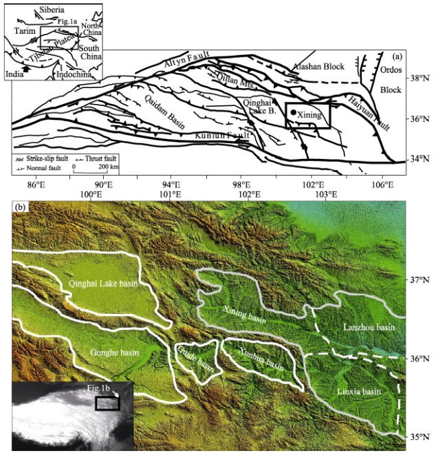
Figure 1 (a) Simplified map of major tectonic boundaries and Tertiary faults in the Northeastern Tibetan Plateau (after Dai et al., 2006); (b) Morphologic characteristics of the NETP derived from Aster Global Digital Elevation Model data

2 Geological and geomorphological background

The NETP, undergoes coeval crustal shortening and left-lateral strike-slip faulting, related to the northeastward growth of the plateau margin as a result of the collision of the Indian and Asian plates. The crustal deformation primarily due to these relative plate motions is expressed by folding and faulting of the Paleozoic to Cenozoic bedrock (Figure 1). Within the NETP, also syn-orogenic basins were formed, such as the Gonghe basin (Craddock et al., 2010), Linxia basin (Li et al., 1997), Baode basin (Pan et al., 2010; Hu et al., 2017) and Xining basin (Figure 1). The basins have been filled with thick continental clastic red beds, while simultaneously the surrounding highs were bevelled (as in the areas surrounding the Xining basin, see further discussion below). Subsequently, the area was incised by rivers in response to regional tectonic uplift of the Tibetan Plateau and local deformation affecting even the red basin fills, probably during the Pliocene and Pleistocene (Li, 1997; Fang et al., 2005; Gao et al., 2008; Stroeven et al., 2009; Craddock et al., 2010; Hu et al., 2017).
The deformation in the study area was controlled by two major large sinistral strike-slip faults, the Altyn-Haiyuan Fault in the north and the Kunlun Fault in the south (Figure 1; Tapponnier et al., 2001; Dai et al., 2006). The offset along these faults decreases gradually in eastward direction, which is accommodated by internal compressive deformation (Tapponnier et al., 2001; Dai et al., 2006). This deformation has resulted in a tectonic mosaic, consisting of open folds, and reverse and normal, dextral- and sinistral strike-slip faults, leading to the formation of alternating subsided and uplifted blocks of more limited extent than the large Mesozoic-Early Cenozoic basins, resulting in a fragmentation and compartmentalization of the former basins and inter-basin areas (Figure 1).
The Yellow River and its tributary, such as Huangshui River which is the focus of the study, follows a series of those uplifted and subsided blocks that resulted from the fragmentation of the Xining and other basins. The basement of the Xining Basin consists of Proterozoic gneisses and schists, Cambrian gray limestones and green basalts and Mesozoic clastic sediments (QBGMR, 1991; Dai et al., 2006). Cenozoic successions of playa to fluvio-lacustrine environments, concordantly overlying the Cretaceous clastic sediments or discordantly older basement rocks, have been subdivided into the Xining and Guide Groups. In addition, ‘fanglomeratic’ rocks unconformably overlie the Guide Group (QBGMR, 1991; Dai et al., 2006). The Huangshui cut ~600 m into the Cenozoic strata and the Proterozoic-Mesozoic basement rocks, and meanwhile built a well-shaped staircase of terraces in the Xining basin (Figure 2) (Lu et al., 2004a; Vandenberghe et al., 2011). The youngest deposits consist of aeolian sediments that blanket the landscape.
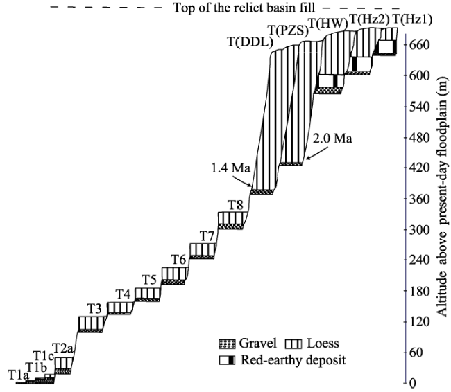
Figure 2 Terrace sequence along a schematic section in the Xining basin (modified after Lu et al., 2004a, and Vandenberghe et al., 2011)

3 Quartz Optically Stimulated Luminescence (OSL) dating of fluvial sediments in the NETP

Datings are the prerequisite to unravel the details of the relationship between the fluvial events (as terrace formation, processes of erosion and deposition) and climate changes, and they are also significant to examine the neo-tectonic process in the NETP. It is difficult to establish a reliable chronological control by 14C dating for the last-glacial events in the study region because of the dating limit (<45 ka) and the lack of suitable dating materials in this arid and cold area. The typical fluvial channel sands, floodloam sediments, outwash fans and glacial- and fluvio-glacial sediments were successfully dated using quartz optically stimulated luminescence (OSL) with the single aliquot regenerative-dose (SAR) protocol (Wang et al., 2013, 2014, 2015).
A small but sufficient amount of fine-sand quartz could be extracted to permit standard SAR-OSL analysis. The measurements using small aliquots (or single grains) might be the best to assess the degree of partial bleaching and date glacial and glacio-fluvial sediments, as they are likely to suffer from poor or inhomogeneous bleaching. However, the measurements show that OSL signals of most samples in the Tibetan Plateau were not bright and that their luminescence sensitivity was low (Wang et al., 2013). The results of the measurements using small aliquots for selected relatively bright samples show the distributions of the equivalent doses are broad, with relative standard deviations in the range of ~16% to 26%, and display little or no asymmetry (Figure 3) (Wang et al., 2013). In addition, the un-weighted average De’s using small aliquots are not different from the values obtained using large aliquots. These results indicate a well-bleached nature of glacial- and fluvial sediments in the NETP, and do not hint at incomplete resetting as a significant source of error. Also, it has been ar-gued (see e.g. Murray and Olley, 2002; Jain et al., 2003) that incomplete resetting is unlikely to give rise to significant age overestimations for samples older than a few ka, even in glacio-fluvial environments. Thus the Quartz-based ASR-OSL analysis could provide robust age control for glacial and fluvial terrace deposits in the NETP, although they should, at least in principle, be considered as maximum ages.
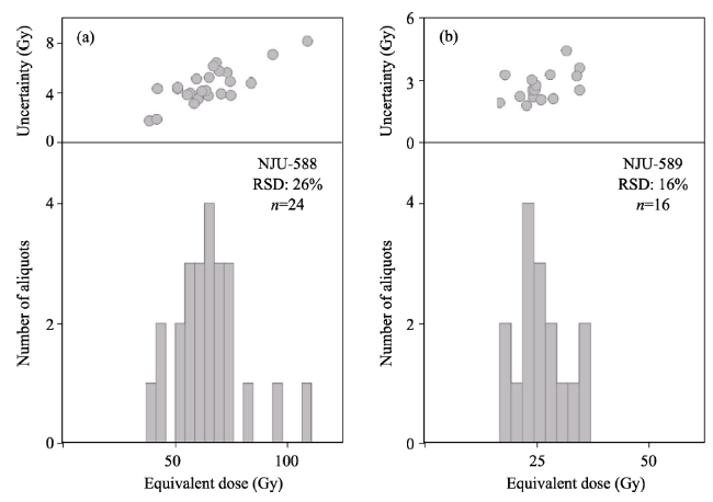
Figure 3 Histogram of De distribution for typical samples in Menyuan basin using small aliquots (after Wang et al., 2013)

4 Morpho-tectonic and geomorphological evolution of the NETP

Several stages can be discriminated in the geomorphological evolution of the Huangshui catchment, inferred from basin filling, planation and fluvial terraces in the Huangshui catchment (Vandengerghe et al., 2011; Wang et al., 2012). During the first stage, the landscape consisted of mountains and filled-up basins that were leveled synchronously, ultimately resulting in the formation of a peneplain (Figure 4). This peneplain thus consists partly of a bedrock surface and partly of the eroded top of the basin fills. This kind of surface has also been documented at several other places besides in Huangshui catchment (e.g., Clark et al.,2006; Pan et al., 2007; 2010, 2012; Craddock et al., 2010; Hu et al., 2017). Indeed, two planation surfaces on the top of folded strata from the eastern Qilian Mountains, around one hundred km north of the Huangshui catchment have been reported by Pan et al. (2007): an older ‘main surface’ and a younger ‘erosion surface’ (1.4 Ma). According to its age (Wang et al., 2012), the peneplain-like surface in the Huangshui catchment might be equivalent to the 'main surface' in the eastern Qilian Mountain. During the second stage, the Huangshui incised into the peneplain surface, producing a terrace sequence (Figure 4). The transition from peneplain formation to incision in the study region was dated as older than 10-6 Ma using the biochronology of micromammalian assemblages from fluvial terraces. In addition, it is should be younger than the final filling of the tectonic basins, that is around 17 Ma according to Dai et al. (2006).
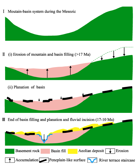
Figure 4 Schematic diagram illustrating the geomorphologyical evolution of the Xining basin and the formation of the relict surface (modified after Wang et al., 2012). Firstly, the tectonic basin was formed before the Mesozoic (I). Then, the surrounding mountains eroded and the basin was filled (II,i). As a last stage in this step, limited and very local erosion in the basin might have slightly lowered the surface formed in II (i), ultimately resulting in the formation of a peneplain surface (II, ii). Finally, tectonic uplift caused the Huangshui to incise vertically into the surface, producing a terrace sequence (III).
Erosion surfaces have served as important markers of tectonic uplift and deformation (e.g., Epis and Chapin, 1975; Spotila and Sieh, 2000; Clark et al., 2004). The combination of rapid fluvial incision into bedrock and relict geomorphic surfaces have been interpreted to reflect a tectonic uplift on the southern Tibetan Plateau margin with a magnitude equal to the incision depth (Burbank et al., 1996). At the southeastern margin of the Tibetan Plateau, relatively flat and highly elevated surfaces of postulated pre-uplift age were also reported, which were heavily dissected, creating steep fluvial valleys, and indicating the relative lowering of base levels due to tectonic uplift (Clark et al., 2004, 2006; Schoebohm et al., 2004, 2006). Thus, the end of basin filling and the start of the incision in the Huangshui catchment may thus be attributed to an important uplift event starting at around 10-17 Ma ( Lu et al., 2004a; Wang et al., 2012).
The entrenchment rate of the Huangshui was not stable. It accelerated for instance from 2 cm/ka to 19.5 cm/ka at around 2 Ma (Vandenberghe et al., 2011; Wang et al., 2012), indicating a specific phase of accelerated uplift (Lu et al., 2004a; Miao et al., 2008; Vandenberghe et al., 2011; Wang et al., 2012).
Previous studies near the Huangshui catchment, by Pan et al. (2010, 2012), Hu et al. (2017) and Craddock et al. (2010), show that rivers started entrenching from a beveled (erosional) surface at much younger ages, c. 3.7 Ma and 1.8 Ma along the Yellow River. The discrepancy may be explained in several ways. First, the older landscapes at the other sites may not have been preserved; they might have been eroded. Secondly, the relict beveled surfaces may have experienced a complex history with different ages of development in different areas (Clark et al., 2006). The late entrenching of the relict surface reported by the former authors could have been caused by the headward erosion of rivers flowing at a lower level and not by a river properly flowing on top of the peneplain, like in the Huangshui catchment. Thus, a certain lag is possible because of time needed by the headward erosion. In our opinion, the infilling of the large tectonic basins and the peneplain formation should have occurred largely in the same time period on the NETP. But, the effective duration of these different processes, and thus their time of termination, may have been different at different locations. In addition, it was argued that the drainage basin integration, and related excavation of Tertiary-Quaternary sedimentary basins along the Yellow River, led to isostatic uplift, and the development of an internally drained basin in the NETP (Zhang et al., 2014).

5 Fluvial morphology and sedimentology response to small-scaled tectonic movements

The general uplift at 10-17 Ma caused local fragmentation of the Huangshui catchment into blocks of small extent, demonstrated as gorges and depressions (scale of kilometers or maximally, a few tens of kilometers), respectively (Wang et al., 2010; Vandenberghe et al., 2011). These blocks might have undergone relative subsidence and/or uplift (Wang et al., 2010, 2014; Vandenberghe et al., 2011). It has been suggested that the inferred tectonic motions are related to the transpression movements in the NETP as a result of the collision of the Indian and Asian plates (Vandenberghe et al., 2011; Wang et al., 2012). In contrast with the generally persisting uplift of the NETP, at the scale of individual blocks uplift sometimes alternated with relative subsidence, leading to laterally alternating accumulation terraces and erosion terraces (Figure 5) in those blocks (Fluvial deposition (>30 m thick) in the subsided blocks, resulting in accumulation terraces, contrasts with entrenching (resulting in erosional terraces with thin fluvial deposits, i.e., strath terraces) and formation of gorges (where terraces are rare or completely absent) in the uplifted blocks (Figure 6) (Wang et al., 2010). The different rates of uplift and subsidence in the individual blocks resulted in the simultaneous development of erosion and accumulation terraces in different blocks within the same catchment (Figure 6) (Wang et al., 2010; Vandenberghe et al., 2011). In other words, fluvial aggradation may have occurred in specific blocks at the same time rivers incised in other (adjacent) blocks.
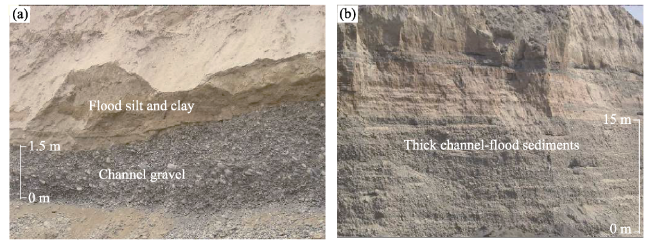
Figure 5 Sedimentologic character of the erosion terrace (a) and the accumulation terrace (b) in the Huangshui catchment
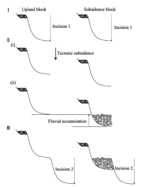
Figure 6 The formation model of the terrace in Huangshui catchment (modified after Wang et al., 2010). Firstly, the fluvial balance state is crossed because of climatic change or tectonic and the river incisions, until reaching to a new balance state; Secondly, the tectonic subsidence happens in the blocks, and an intensified erosion in upstream while a huge volume of sediments supplied deposit quickly in the subsidence depression. Finally, the river incises in the whole catchment, caused by climatic changes such as increasing of the precipitation and the reducing of the sediment load caused by the relevant development of the vegetation cover or tectonic uplift, and the accumulation terraces are formed in the subsidence depressions while the erosion terraces or no terrace are formed in upstream blocks.
In the confluence region of the Huangshui and Huanghe rivers, from the Minhe depression to the west Lanzhou depression, the average river incision rate since -70 ka was much higher than in the up- and down-stream blocks, indicating relative uplift of the confluence region (Wang et al., 2014). At a smaller time scale, somewhere between 20 and 70 ka, two accumulation terraces with thick stacked fluvial deposits (>18 m) indicate two phases of subsidence in the confluence region relative to the up- and down-stream blocks (Wang et al., 2014). This could point to relatively short phases of tectonic stability or even subsidence during a period of general tectonic uplift.
The lateral transition between the very erosion-resistant Palaeozoic rocks of the uplifted block to the much younger and less resistant Tertiary clastic sediments in the depression, such as between Laoya gorge and Minhe depression (Figure 7), normaly corresponds with a very prominent, almost vertical escarpment in the topography (Figure 8), and this morphological escarpment may be interpreted as a fault. The vertical erosion (with formation of the strath terraces) obviously was always the main fluvial activity in the exit of the Laoya gorge, NW of the Huangshui, as a result of the regional tectonic uplift, while in part of the Minhe depression, SE of the Huangshui vertical erosion was interrupted by accumulation at specific periods as a result of local subsidence (Figure 9) (Vandenberghe et al., 2011). It was deduced that different tectonic backgroud caused by faults between the gorge and the depression lead to different fluvial response, a series of erosion terraces and steep cliff formed in the hard bedrock of the Laoya block north of the Huangshui as the general uplift, where erosion and accumulation terraces developed response to general uplift and relatively subsidence, in the Minhe depression, SE of the Huangshui (Figure 9) (Vandenberghe et al., 2011).
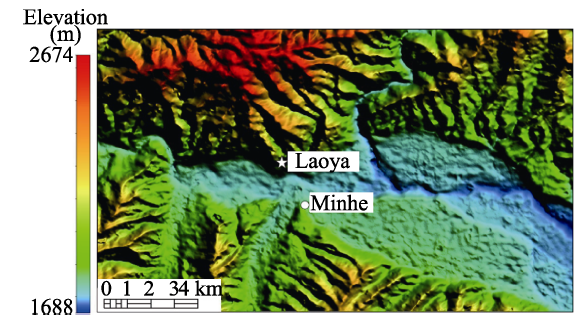
Figure 7 DEM of the Minhe subsided block with the transition to the Laoya gorge in the left upper corner
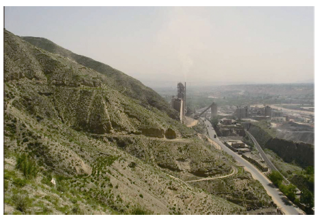
Figure 8 Fault scarp at the boundary between the Laoya block composed of hard rock and the Minhe depression underlain by soft sediments
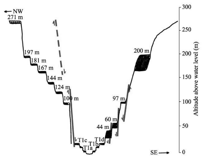
Figure 9 Terrace sequence at the exit of the Laoya gorge and the transition to the western most part of the Minhe basin, and the relation to fault activities (modified after Vandenberghe et al., 2011). Firstly, incision occurred from 271 to 197 m, due to regional tectonic uplift. Secondly, uplift continued in the Laoya block, while the Minhe block subsided, leading to the accumulation of 30 m gravel (terrace at +200 m). Subsequently, uplift was dominant everywhere, resulting in the formation of a series of erosion terraces in the Laoya block between +197 and 100 m; while only one erosional terrace was preserved in the tectonic depression at +100 m. Finally, the recent fault activity, resulted in sharp vertical erosion in Laoya block, while subsidence prevailed in Minhe depression, leading to the formation of two accumulation terraces at 60 and 44 m.

6 Fluvial sediment process and terrace staircases as a response to climatic change

Incision into the former peneplain was not continuous but a staircase of terraces (consisting of at maximum 15 to 20 individual levels in some blocks), developed as a result of climatic influences (Figure 4) (Lu et al., 2004a; Vandenberghe et al., 2011; Wang et al., 2012) . The sedimentary series of the different terraces are similar (Vandenberghe et al., 2011; Wang et al., 2014, 2015). From bottom to top: fluvial gravels of various thickness, interbedded with lenses of sands, silts, and clays, and finally topped by a horizontally laminated silt, occasionally containing gravel strings of limited extent (Figure 10). The lowest part of the gravel deposits consists of massive gravel (Gm) representing channel bedload, grading towards the top into finer-grained, coarsely planar bedding (Gp) (Figure 10). The latter deposits frequently show imbrication and small-scaled cross-bedding, which indicate deposition in lateral and longitudinal bars. Small and shallow channels occur with increasing frequency towards the top of the terrace deposits; they are filled with cross-bedded fine gravel or sands (planar to low-angle trough cross-bedding) (Figure 10). The upper laminated silts are interpreted as floodloam deposits that complete the fluvial sequence prior to or simultaneously with the abandonment of the floodplain as a result of renewed river incision. These sedimentary characteristics of the fluvial gravel-sand deposits, dominated by varying (often cyclic) assemblages of gravel traction-current deposits, clearly point to the shallow gravel-bed braided river systems (Miall, 1996; Lewin and Gibbard, 2010) that contrast with the present-day wandering or meandering pattern of the Huangshui. At several locations, soil formation has been recognized at the top of fluvial depositional sequences, although not being well developed (Vandenberghe et al., 2011; Wang et al., 2014). Mostly, a gradual transition from flood loam to loess is present and the flood loams are often red-colored, pointing to upstream removal or local reworking of soil material.
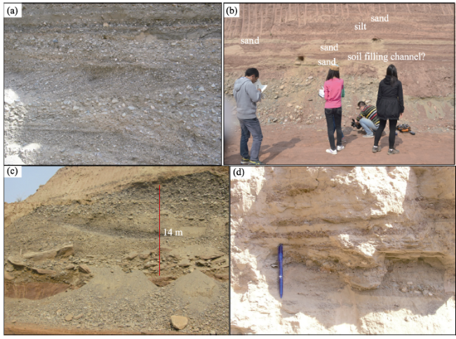
Figure 10 Characteristic sedimentary sequences of terraces: (a) Planar sheets of gravel alternating with finer grained, shallow, trough cross-bedded channels of 44 m terrace above present floodplain in Ledu basin; (b) inter-bedded layers of horizontally-laminated silt reworked soil filling shallow channels; (c) aggradation sequence of -40 m terrace above present floodplain in the eastern part of the Minhe depression; (d) horizontally laminated silts occasionally containing gravel strings of limited extent of 22 m terrace above preset floodplain at east Minhe depression
Climate proxies are mostly absent within the Huangshui terrace deposits, which makes it difficult to prove the link between climate and fluvial processes. Nevertheless, in accordance with the reconstructed character of the river morphology as a shallow gravel-bed braided river (Miall, 1996) that contrasts with the Holocene meandering river, the majority of the (coarse grained) fluvial deposits of the terraces seems to date from cold periods. Subsequently, we assume that, in line with the general model of fluvial development derived for temperate and periglacial environments (Vandenberghe, 2008; 2015), the fine-grained sandy gravels and sands near to the top of the sediment series were deposited during the waning of the same glacial period as a result of the beginning incision of the river (possibly in combination with reduced precipitation). Ultimately the fluvial sediments were capped by interglacial soil formation. Rivers incised slightly at the transition from the glacial to the interglacial, due to less peaked river discharge and the reduction of sediment supply to the river. As a consequence of that new, lower position in the next interglacial, the previous coarse grained channel deposits were flooded only during peak discharges resulting in episodic, fine-grained floodplain deposition, while most of the time soil formation took place on the floodplain. Analogous to the present-day river, the interglacial river was probably less energetic and dominantly meandering. Renewed incision took place at the next interglacial-glacial transition, when fluvial energy considerably increased and sediment transport was still limited. At that time, loess covered the former floodplain deposits and soil without any further reworking by the river (Vandenberghe et al., 2011)

7 Climate-dependent fluvial architecture and processes on a suborbital timescale in areas of rapid tectonic uplift since the last interglacial

In the confluence region of the Huangshui and Huanghe rivers, from the Minhe depression to the west Lanzhou depression, eight fluvial terraces are present (Figure 11), which are dated at around 129-103 ka (T7), 81-73 ka (T6), 68-51 ka (T5), 42-32 ka (T4), 24-22 ka (T3), and 14-13 ka (T2), respectively, using SAR-OSL analysis (Wang et al., 2015). The average river incision rate was 0.87 m ka-1 since the last interglacial, which is much larger than in the upstream Huangshui river (around 0.05-0.06 m ka-1, Vandenberghe et al., 2011), the downstream Huanghe (around 0.35 m ka-1, Pan et al., 2009), and even in most catchments in the world, where long-term average downcutting rates are less than 0.2 m ka-1 (Bridgland and Westaway, 2008), indicating relative uplift of the confluence region. This relatively strong uplift gives more space for differentiation within the terrace staircase as a result of climatic changes, leading to 7 terraces formed as a response to small climatic fluctuations (103-104 year timescale) (Wang et al., 2015). Assuming that the OSL-age is reliable, it leads to the striking conclusion that the stronger the tectonic movement the better the climatic imprint is expressed in the terrace development.
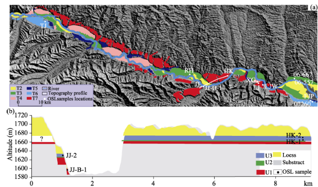
Figure 11 (a) Terrace distribution in the confluence region of the Huangshui and Huanghe rivers (modified after Wang et al., 2014). (b) A selected topographic section from Figure 11a, illustrating a typical terrace sedimentary sequence. U1, U2, U3 are the sedimentary units of the terraces (U1: stacked fluvial gravels of varying thickness with inter-bedded sand lenses, U2: cross-stratified sands, U3: inter-bedded layers of horizontally-laminated silt and sands.)
The dating results show that for each terrace, the lower coarse-grained sediments (gravel and sand) were deposited during cold periods (such as the LGM, MIS3b, MIS4 and MIS5d) associated with a strong Asian winter monsoon (Figure 12). The coarsegrained cold phase deposits are covered by inter-bedded, horizontally- laminated silt and sand (representing flood sediments that often contain reworked soil material), during the (cold to warm) transitional phases. The floodplain accumulation on the terrace continued during the subsequent warm period. The warm periods (such as MIS3a, MIS3c, and MIS5a) of the climatic cycles are associated with a strong Asian summer monsoon (Figure 12). Pronounced incision took place at the subsequent warm-cold transitions (Figure 13). After this warm-cold transition, aeolian loess accumulated on the abandoned terrace without any further fluvial reworking. It demonstrates that critical thresholds for fluvial response can be crossed at climatic changes on a suborbital timescale given conditions of accelerated tectonic uplift in the NETP.
Figure 12 Comparison of the age of terraces (T2, T3, T4, T5, T6 and T7) and periods of fluvial deposition (at top) with climatic evolution recorded by the grain-size record of loess deposits at GL (gray) (Sun et al., 2012) and YZ (red) (Lu et al., 2004b) in the NETP (modified after Wang et al., 2015). Green, black and blue codes of ages and errors (2σ error bars at top) correspond to sedimentary units (U1, U2, and U3, similar to that in Figure 11), respectively. Numbers indicate marine isotope stages and substages. Age of loess deposit sequence is based on 20 OSL datings of GL by Sun et al. (2012) and correlation to marine isotope stages in YZ (Lu et al., 2004b).
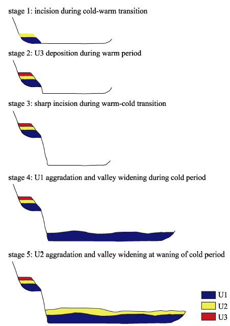
Figure 13 Schematic diagram illustrating the terrace formation in response to climatic change in the confluence of Huangshui and Huanghe. U1, U2, U3 are the sedimentary units of the terraces, similar to that in Figure 11.

8 Conclusions and remarks

The substantial tectonic uplift of the Northeastern Tibetan Plateau (NETP), together with the major climatic changes, provides an opportunity to study the impact of tectonic and climatic changes on the morphological development and sedimentary architecture of fluvial deposits. The effects of these processes are revealed by a terrace staircase, together with the stratigraphy of each individual terrace. A peneplain-like surface and the related landscape transition from basin filling to incision happened at least before the late Miocene in the NETP, which indicates that an intense uplift event with morphological significance happened around 10-17 Ma in the NETP. The general uplift at 10-17 Ma caused local fragmentation of the Huangshui catchment into blocks of small extent, demonstrated as gorges and depression. After that, incision into the former peneplain was not continuous but a staircase of terraces, developed as a result of climatic influences. Since the late Miocene, in spite of generally persisting uplift of the whole region, the neighbouring tectonic blocks had different uplift rates, and the uplift rates could change on a time scale of 10 ka. This tectonic differentiation causes a complicated fluvial response with accumulation terraces alternating with erosion terraces at a small spatial and temporal scale. Fluvial aggradation occurred during cold periods in general. Rivers progressively incised, reaching only sporadically the previous floodplain at the transition warm periods. The resuming vegetation cover reduced sediment supply to the rivers so that. This change in fluvial activity as a response to climatic impact is reflected in the general sedimentary sequence on the terraces from high-energy (braided) channel deposits (at full glacial) to lower-energy deposits of small channels (towards the end of the glacial), mostly separated by a rather sharp boundary from overlying flood-loams (at the glacial-interglacial transition) and overall soil formation (interglacial). Pronounced incision took place at the subsequent warm-cold transitions. In addition, it is hypothesized that in some strongly uplifted blocks energy thresholds could be crossed to allow terrace formation as a response to small climatic fluctuations (103-104 year timescale).
Although studies of morpho-teconic and geomorphological evolution of the NETP, improve understanding on the impacts of tectonic motions and monsoonal climate changes on fluvial processes, a number of questions remain to be answered and carried out in the future: 1) How far are the peneplain and the related morphological features and can they be correlated over large distances? 2) Morphological features as terraces and peneplains at different blocks have to be dated more precisely to make better correlations and, therefore, firmer hypotheses on morphological evolution and the link in different blocks and/or in different tectonic settings. 3) Can we specify in more detail to what extent and intensity tectonic movements may influence the crossing of climatic thresholds, leading to terrace development?

The authors have declared that no competing interests exist.

[1]
Bridgland D R, 2000. River terrace systems in north-west Europe: An archive of environmental change, uplift and early human occupation.Quaternary Science Reviews, 19: 1293-1303.Staircases of large-scale aggradational river terraces are a notable feature of many valleys in the temperate lattitudes, particularly in areas beyond the reach of the erosive activities of Pleistocene ice sheets. It is now recognized that the cyclic fluctuations of climate during the Quaternary have driven the generation of terraces, through the direct and indirect influence of both temperature and precipitation on fluviatile activity. Where fossiliferous deposits are preserved within terrace sequences it is often possible to date these and to correlate them with the oceanic record, thus providing an important framework for the evidence of environmental change on land. Middle and Late Pleistocene terraces in different areas can commonly be seen to have formed in synchrony with glacial nterglacial cycles or with longer-periodicity megacycles. Climatic forcing alone is insufficient to cause terraces to form, however; uplift is also necessary, so that terrace sequences can provide a useful record of crustal movement. In northwest Europe, where some of the best known studies of river terrace sequences have been carried out, the fluviatile deposits are also an important repository for Palaeolithic artefacts, from which a record of early human occupation can be reconstructed.

DOI

[2]
Bridgland D R, Westaway R, 2008. Climatically controlled river terrace staircases: A worldwide Quaternary phenomenon.Geomorphology, 98: 285-315.A comparison of fluvial terrace sequences from around the world, based on data collected as part of International Geoscience Programme (IGCP) Project No. 449, has revealed significant patterns. River terraces provide important records of uplift, which is essential for their formation, and of landscape evolution. Their cyclic formation, however, almost invariably seems to have been a response to climatic fluctuation. Sequences in the European core area of IGCP 449, which has the longest and most extensive research history, have been used as templates for worldwide comparison. There is evidence for a global acceleration of uplift at the time of, and perhaps in response to, the Mid-Pleistocene Revolution, when climatic fluctuation switched to 100kyr Milankovitch cycles. Terraces formed prior to this generally consist of wide aggradational sheets that probably each represent formation over several 41kyr cycles. Subsequently, river valleys became more steeply entrenched and terraces formed in response to the stronger 100kyr climatic forcing, in many cases at approximately one per cycle. This paper uses the new data resource to explore differences between records in different climate zones, between sequences with variable numbers of Middle ate Pleistocene terraces and between systems in which the all-important incision event has occurred in different parts of climatic cycles. Key records discussed include European examples from the Rhine, Thames, Somme, Dniester, Dnieper, Don, Volga and Aguas; from Asia the Gediz (Turkey) and Orontes (Syria); from North America, the South Platte and Colorado; from South Africa the Vaal and Sundays; from Australia the Shoalhaven; and from South America, the Amazon, Paraguay and tributaries of the Colorado and Negro.

DOI

[3]
Bridgland D V, Demir T, Seyrek Aet al., 2017. River terrace development in the NE Mediterranean region (Syria and Turkey): Patterns in relation to crustal type.Quaternary Science Reviews, 166: 307-323.It is widely recognized that the optimal development of river terraces globally has been in the temperate latitudes, with NW and Central Europe being areas of particular importance for the preservation of such archives of Quaternary environmental change. There is also a growing consensus that the principal drivers of terrace formation have been climatic fluctuation against a background of progressive (but variable) uplift. Nonetheless river terraces are widely preserved in the Mediterranean region, where they have often been attributed to the effects of neotectonic activity, with a continuing debate about the relative significance of fluctuating temperature (glacials–interglacials) and precipitation (pluvials–interpluvials). Research in Syria and southern–central Turkey (specifically in the valleys of the Tigris and Ceyhan in Turkey, the Kebir in Syria and the trans -border rivers Orontes and Euphrates) has underlined the importance of uplift rates in dictating the preservation pattern of fluvial archives and has revealed different patterns that can be related to crustal type. The NE Mediterranean coastal region has experienced unusually rapid uplift in the Late Quaternary. The relation between the Kebir terraces and the staircase of interglacial raised beaches preserved along the Mediterranean coastline of NW Syria reinforces previous conclusions that the emplacement of the fluvial terrace deposits in the Mediterranean has occurred during colder climatic episodes.

DOI

[4]
Büdel J, 1977. Klima-Geomorphologie. Berlin: Gebrüder Bornträger, 304.

[5]
Burbank D W, Leland J, Fielding Eet al., 1996. Bedrock incision, rock uplift and threshold hillslopes in the northwestern Himalayas.Nature, 379: 505-510.The topography of tectonically active mountain ranges reflects a poorly understood competition between bedrock uplift and erosion. Dating of abandoned river-cut surfaces in the northwestern Himalayas reveals that the Indus river incises through the bedrock at extremely high rates (2-12 mm yr). In the surrounding mountains, the average angles of hillslopes are steep and essentially independent of erosion rate, suggesting control by a common threshold process. In this rapidly deforming region, an equilibrium is maintained between bedrock uplift and river incision, with landsliding allowing hillslopes to adjust efficiently to rapid river down-cutting.

DOI

[6]
Clark M K, Royden L H, Whipple K Xet al., 2006. Use of a regional, relict landscape to measure vertical deformation of the eastern Tibetan Plateau.Journal of Geophysical Research-Earth Surface, 111: 1-23.1] Field work and topography analysis show that remnant, local areas of a low-relief landscape or erosion surfaces are geographically continuous across the southeastern Tibetan Plateau margin. We correlate these remnant surfaces as a paleolandscape that formed at low elevation. Remnants of this paleolandscape are preserved because incision of the fluvial system has been largely limited to major rivers and principal tributaries and has not yet progressed throughout the entire fluvial network. The incomplete adjustment of the fluvial system signals initiation of rapid bedrock incision into a developing plateau margin, and erosional denudation is concentrated in the major river channels. This interpretation contradicts earlier notions that low-gradient, regional topography is the product of regional elevation reduction by intense landscape dissection due to the presence of several large southeast flowing rivers. The modern altitude of the reconstructed paleolandscape (or elict landscape ) constrains the vertical displacement of the plateau surface in response to crustal thickening and subsequent erosion during the lateral growth of the Tibetan Plateau. Regional preservation of the relict landscape is consistent with minor surface disruption by late Cenozoic thrust faults and folds and supports a model of distributed lower crustal thickening. Because significant erosion is limited to narrow river gorges, an increase in the plateau elevation due to isostatic rebound is minor. Therefore we propose that the modern elevation of the relict landscape reflects isostatically compensated thickening of the lower crust.

DOI

[7]
Clark M K, Schoenbohm L M, Royden L Het al., 2004. Surface uplift, tectonics, and erosion of eastern Tibet from large-scale drainage patterns.Tectonics, 23: 1-20.A new regional compilation of the drainage history in southeastern Tibet suggests that the modern rivers draining the plateau margin were once tributaries to a single, southward flowing system which drained into the South China Sea. Disruption of the paleo-drainage occurred by river capture and reversal prior to or coeval with the initiation of Miocene (?) uplift in eastern Tibet, including 2000 m of surface uplift of the lower plateau margin since reversal of the flow direction of the Yangtze River. Despite lateral changes in course due to capture and reversal, the superposition of eastward and southward draining rivers that cross the southeastern plateau margin suggests that uplift has occurred over long wavelengths (>1000 km), mimicking the present low-gradient topographic slope. Thus reorganization of drainage lines by capture and reversal events explains most of the peculiar patterns of the eastern plateau rivers, without having to appeal to large-magnitude tectonic shear.

DOI

[8]
Cordier S, Briant B, Bridgland Det al., 2017. 'The fluvial archives group: 20 years of research connecting fluvial geomorphology and palaeoenvironments.Quaternary Science Reviews, 166: 1-9.

DOI

[9]
Craddock H W, Kirby E, Harkins W Net al., 2010. Rapid fluvial incision along the Yellow River during headward basin integration.Nature Geoscience, 3: 209-213.The onset of rapid exhumation along the high relief margins of orogenic plateaux is often used as a proxy for the timing of surface uplift. However, processes that inhibit incision by rivers, such as spatially variable rock uplift, orographic changes in rainfall and channel damming by glaciers or landslides may lead to exhumation that significantly lags surface uplift. Here we reconstruct the timing, rate and pattern of fluvial incision along the Yellow River in northeastern Tibet using stratigraphic, geochronologic and geomorphic data from sedimentary basins along the present-day river course. We find that the onset of fluvial incision occurred substantially later than the onset of mountain building, 14-8million years (Myr) ago. Fluvial incision initiated at the plateau margin 1.8Myr ago and progressed upstream at a rate of approximately 350kmMyr. We conclude that the fluvial incision was a result of a climatically driven expansion of lake systems in the region that led to lake spillover and consequently the integration of the modern Yellow River.

DOI

[10]
Dai S, Fang X, Dupont-Nivet Get al., 2006. Magnetostratigrpahy of Cenozoic sediments from the Xining Basin: Tectonic implications for the Northeastern Tibetan Plateau.Journal of Geophysical Research, 111: B11102. doi: 10.1029/2005JB004187.The Xining subbasin of the Longzhong basin holds the longest continuous Cenozoic stratigraphic record at the margin of the northeastern Tibetan Plateau. Despite a rich biostratigraphic content (including the Xiejia mammal fauna), the tectonic evolution of the basin is largely unconstrained. In this study we present stratigraphic, biostratigraphic, and magnetostratigraphic results that provide a basis for reconstructing the Cenozoic tectonic evolution of the Xining basin with respect to adjacent regions of the northeastern Tibetan Plateau. Magnetostratigraphic analysis from three red bed sections in the Xining basin indicates continuous deposition at low and nearly constant accumulation rates (average 2.2 cm/kyr) from 52.0 to 17.0 Ma. We interpret this result to indicate that no major regional tectonic event implying large sediment accumulation variations has affected the Xining basin deposition during this considerable time window. In detail, accumulation rate variations outline a three-stage evolution with 1.8 cm/kyr from 52.0 Ma to 34.5 Ma, 4.1 cm/kyr from 34.5 to 31.0 Ma, and 2.3 cm/kyr from 31.0 to 17.0 Ma. The second-order increase between 34.5 and 31.0 Ma can be interpreted to result from either a distal tectonic event or to be of climatic origin. Although the region was tectonically quiescent for much of the Cenozoic, tectonic activity occurred during basin initiation (or reactivation) at circa 55.0-52.5 Ma and during intense basin deformation after 17.0 Ma.

DOI

[11]
Demoulin A, Mather A, Whittaker A, 2017. Fluvial archives, a valuable record of vertical crustal deformation.Quaternary Science Reviews, 166: 10-37.As well as the erosional imprint of tectonic forcing, sedimentary deposits, such as fluvial terrace staircases, are also considered as a classical component of tectonic geomorphology. We show that these studies have recently benefited from rapid advances in dating techniques, allowing more reliable reconstruction of incision histories and estimation of incision rates. The combination of progress in the understanding of transient river profiles and larger, more rigorous data sets of terrace ages has led to improved understanding of river erosion and the implications for terrace profile correlation, i.e., extrapolation of local data to entire profiles. Finally, planform changes in fluvial systems are considered at the channel scale in alluvial rivers and regional level in terms of drainage reorganisation. Examples are given of how numerical modelling can efficiently combine with topographic data to shed new light on the (dis)equilibrium state of drainage systems across regional drainage divides.

DOI

[12]
Epis R C, Chapin C E, 1975. Geomorphic and tectonic implications of the post-Laramide Late Eocene erosion surface in the Southern Rocky Mountains.Geological Society of America Memoir, 144: 45-74.

DOI

[13]
Fang X M, Yan M D, Van der Voo Ret al., 2005. Late Cenozoic deformation and uplift of the NE Tibetan Plateau: Evidence from high-resolution magnetostratigraphy of the Guide Basin, Qinghai Province, China.Geological Society of America Bulletin, 117: 1208-1225.The Cenozoic intramontane Gonghe-Guide Basin in Qinghai Province, China, is tectonically controlled by the sinistral strike-slip framework of the Kunlun and Altyn Tagh-South Qilian faults in the northeastern Tibetan Plateau. The basin is filled with thick Cenozoic clastic sedimentary formations, which provide important evidence of the deformation of this part of the plateau, although they have long lacked good age constraints. Detailed magnetostratigraphic and paleontologic investigations of five sections in the Guide Basin and their lithologic and sedimentary characteristics allow us to divide a formerly undifferentiated unit (the Guide Group) into six formations (where ages are now magnetostratigraphically well established, they are given in parentheses): the Amigang (1.8-2.6 Ma), Ganjia (2.6-3.6 Ma), and Herjia formations (3.6 to ca. 7.0-7.8 Ma), and the older Miocene Ashigong, Garang, and Guidemen formations. These rocks document a generally upward coarsening sequence, characterized by increasing accumulation rates. Increasing gravel content and sizes of its components, changes of bedding dips and source rock types, and marginal growth faults collectively reflect accelerated deformation and uplift of the NE Tibetan Plateau after 8 Ma, punctuated by a sharp increase in sedimentation rate at ca. 3.2 Ma that reflects the boulder conglomerates of the Ganjia formation. Interestingly, much of the vergence of the compressional deformation in the basin is to the south, accommodated by a sequence of six thrusts (F1-F6), which become active one by one progressively later toward the south, undoubtedly contributing to the uplift of this part of the plateau. F1 likely initiated the Guide Basin due to crustal flexure in the Oligocene, F2 was active in the early Miocene, F4 and FS at ca. 3.6 Ma, and F6 was active in the early Pleistocene. The detailed late Miocene and younger magnetostratigraphy allows us to place much improved time constraints on the deformation and, hence, uplift of northeastern Tibet, which, when compared with ages for events on other parts of the plateau, provides important boundary conditions for the geodynamical evolution of Tibet.

DOI

[14]
Gao H, Li Z, Ji Yet al., 2016. Climatic and tectonic controls on strath terraces along the upper Weihe River in central China.Quaternary Research, 86: 326-334.The Weihe River in central China is the largest tributary of the Yellow River and contains a well-developed strath terrace system. A new chronology for the past 1.11 Ma for a spectacular flight of strath terraces along the upper Weihe River near Longxi is defined based on field investigations of loessu2014paleosol sequences and magnetostratigraphy. All the strath terraces are strikingly similar, having several meters of paleosols that have developed directly on top of fluvial deposits located on the terrace treads. This suggests that the abandonment of each strath terrace by river incision occurred during the transition from glacial to interglacial climates. The average fluvial incision rates during 1.11u20140.71 Ma and since 0.13 Ma are 0.35 and 0.32 m/ka, respectively. These incision rates are considerably higher than the average incision rate of 0.16 m/km for the intervening period between 0.71 and 0.13 Ma. Over all our results suggest that cyclic Quaternary climate change has been the main driving factor for strath terrace formation with enhanced episodic uplift.

DOI

[15]
Gao H, Liu X, Pan Bet al., 2008. Stream response to Quaternary tectonic and climatic change: Evidence from the upper Weihe River, central China.Quaternary International, 186: 123-131.Seven terraces of upper Weihe River in the Longxi Basin on the north flank of the Qinling Mountains are capped with a succession of loess units and paleosols that correlate with the standard marine isotope chronology. Based on fieldwork and terrace ages, which were determined using loess-paleosol stratigraphy, paleomagnetic, optical stimulated luminescence (OSL) and radiocarbon dating, the results show that the fluvial fills were deposited during marine oxygen isotope stages (MISs) 22, 20, 18/16, 12, 6, 4 and 2, respectively, whereas terracing occurred during glacial–interglacial transitions. This, in turn, points to eccentricity-related climatic changes that may have driven recurrent incision and aggradation processes and significantly influenced the formation of staircase terraces of Weihe River, through the direct and indirect influence of both temperature and precipitation on fluviatile activity. On the basis of terrace ages and its heights, incision rates were enhanced from 865 to 41202ka (650.2702m/ka), decreased from 412 to 12802ka (650.0902m/ka), and increased from 12802ka to present (650.3202m/ka).

DOI

[16]
Hu Z, Pan B, Bridgland Det al., 2017. The linking of the upper-middle and lower reaches of the Yellow River as a result of fluvial entrenchment.Quaternary Science Reviews, 166: 324-338.Under the constraint of this chronological framework, a model for landscape evolution is proposed here. Uplift of the inner Fenwei graben and of the surrounding mountain ranges led to dissection of the 3.63 Ma old planation surface in conjunction with the formation of the Sanmen gorge. Drainage of the lake previously occupying the basin would have promoted incision into the fluvio-lacustrine graben sediments; indeed, gorge formation through the Xiaoshan may have been initiated or intensified by lake overflow. The ages obtained for the planation surface and uppermost terrace suggest that the formation of the Sanmen gorge and the initiation of the through-going eastward drainage of the Yellow River occurred between 3.63 and 1.24 Ma. Before the start of gorge entrenchment, the products of erosion in the modern upper catchment of the Yellow River were unable to reach the sea. The dramatic increase in deposition rates in the Bohai Gulf (at the mouth of the modern Yellow River in the East China Sea), 1.0 Ma ago, thus resulted from the initiation of an integral (enlarged) Yellow River catchment drainage through the Sanmen gorge; it does not imply an increase in erosion rates at that time.

DOI

[17]
Jain M, Murray A S, Bøtter-Jensen L, 2003. Optically stimulated luminescence dating: How significant is incomplete light exposure in fluvial environments?Quaternaire, 15: 143-157.ABSTRACT Optically stimulated luminescence (OSL) dating of fluvial sediments is widely used in the interpretation of fluvial response to various allogenic forcing mechanisms during the last glacial-interglacial cycle. This dating method offers direct dating of the last time the sediment was exposed to daylight (in contrast to 14C dating which uses contextual material) and can provide ages up to 200 ka. It is based on the assumption that any prior dating signal is released, and the luminescence clock reset, when the sediment is exposed to daylight before or during deposition. For young fluvially-transported sediment, daylight exposure may not be sufficient to meet this assumption adequately. One way to investigate the importance of this assumption is to examine the range of signals obtained from modern samples and/or the ages from the older samples with independent age control. We provide here a non-specialist review highlighting some key aspects of recent development in the OSL dating technique relevant to the Quaternary fluvial community, and describe studies on dating of fluvial sediments with independent chronological control, and on recent fluvial sediment. We conclude that a) there is an excellent correlation between OSL and independent ages for samples older than 1000 years, b) For samples younger than 1000 years, partial bleaching affects the accuracy of the results and minimum-age calculations based on dose distributions should be employed, c) for modern samples the apparent age offsets range from a few years to few thousand years, and seem to be inconsistent with observed offsets in OSL ages from the stratigraphic record. This is attributed to biased sampling of local events in the modern record with a poor preservation potential. It is speculated that so-called 'modern analogue' samples may in fact represent the 'most poorly bleached case' for testing for the importance of partial bleaching in older samples. The relevance of such 'zeroing' tests can probably be improved significantly by dating known-age recent samples, say older than 200 years, rather than truly modern samples. Finally, we suggest that d) the use of single grain dating for sediment younger than I ka should be examined to help us understand the scale-dependencies of bleaching processes in fluvially transported materials.

DOI

[18]
Jia L, Hu D, Wu Het al., 2017. Yellow River terrace sequences of the Gonghe-Guide section in the northeastern Qinghai-Tibet: Implications for plateau uplift.Geomorphology, 295: 323-336.The uplift of the Tibetan Plateau was a significant event in terms of global landforms and climate, but the exact nature of the uplift process remains contested among geologists. In the uplifted inland area of the plateau, river-terrace formation has been controlled mainly by tectonic uplift, which means that analyses of river terraces are an excellent means of investigating the uplift process. In this paper, we establish the terrace sequence of the Yellow River in the Gonghe–Guide section of the northeastern Tibetan Plateau, making use of field investigations, gravel analysis, and electron spin resonance (ESR) dating. Terraces T3–T9 of the numbered sequence formed at ~020.13, 0.18, 0.23, 0.41, 0.85, 0.93, and 1.3202Ma, (moving backwards in time and upwards from the valley floor), whereas terraces T11–T20 formed at ~021.71, 1.75, 1.88, 1.94, 2.01, 2.12, 2.23, 2.31, 2.36, and 2.4702Ma. This suggests that the Yellow River existed in Gonghe and Guide basins for at least the last 2.4702Ma. The incision rates of the Yellow River in the Gonghe–Guide section indicate that there were three distinct phases of uplift of the northeastern Tibetan Plateau, occurring at different rates, with an average uplift rate of ~020.2602mm/yr during the Quaternary. These results support the multi-stage uplift model, which states that the Tibetan Plateau has experienced continuous uplift since 802Ma, but contradicts both the early uplift theory, which holds that the uplift of the Tibetan Plateau occurred mainly before the Pliocene, and the notion of a late and rapid uplift of the plateau that began at 3.602Ma.

DOI

[19]
Knox J, 1972. Valley alleviation in southwestern Wisconsin.Annals of the Association of American Geographers, 62: 401-410.ABSTRACT Meander erosional banks of fifth and sixth order southwestern Wisconsin streams having drainage areas of twenty square miles (30 km2) or less frequently reveal three distinct sedimentary sequences. The basal unit of coarse textured debris is thought to represent bed load sediment of a prior channel active near the terminus of a mid-Holocene drought about 6,000 years B. P. A silty clay series over the coarse layer is interpreted to have been derived by vertical accretion on a paleo floodplain during a climatic shift toward more humid conditions of the late Holocene. Distinctly laminated silt loam sediments produced by vertical accretion extend from the middle series to the current surface, and mainly result from increased flooding related to modern land use practices. The recent man-induced change in channel morphology is analogous to natural adjustments produced by Holocene climatic fluctuation, and suggests that temporal aspects of channel and floodplain evolution may be described by a step function model.

DOI

[20]
Lewin J, Gibbard P L, 2010. Quaternary river terraces in England: Forms, sediments and processes.Geomorphology, 120: 293-311.Flights of Quaternary river terraces in south and east England have common characteristics involving low-gradient planed or irregular bedrock surfaces and single or multi-storey gravel deposits. Rather than depending on warm–cold or cold–warm transitions, it is suggested that bedrock planation, “working depths” of gravel and later-stage (relatively shallow) aggradations are all dominantly of cold-climate origin. Basal sediments show active incorporation of plucked and periglacially-shattered materials, whilst super-incumbent units incorporating up-catchment and slope-derived materials demonstrate later cold-stage sediment influx and consequent cessation of active bedrock erosion. Channel activity effecting both planation and deposition are reviewed, together with the detailed sedimentology of gravelly sediments which show evidence of both autogenic processes (bar migration, channel switching and infilling, and truncation of upper sedimentation units), cold-climate indicators (turbation, ice-wedge casts, and frozen block transport), and (specifically for the last glacial–interglacial cycle) varying sediment flux as climates changed. Both interglacial and “transitional” activities are believed to be of lesser morphological significance, whilst prior uplift is taken as enabling rather than being a generator of terrace within the timescale of a glacial–interglacial cycle. Variations within cold-stage climates, varying sediment influx and channel-belt bedrock erosion are stressed as dominating mid-catchment and mid-latitude Quaternary terracing at the glacial–interglacial scale.

DOI

[21]
Li J J, Fang X M, Van der Voo Ret al., 1997. Magnetostratigraphic dating of river terraces: Rapid and intermittent incision by the Yellow River of the northeastern margin of the Tibetan Plateau during the Quaternary.Journal of Geophysical Research, 102(B5), 10121-10132.Up to 23 paleosols have been identified in loess sequences that overlie fluviatile sediments on seven terraces of Huang He (the Yellow River) and Daxia He in the Linxia Basin at the northeastern margin of the Tibetan Plateau. The magnetostratigraphic record in the oldest sequence appears to be fairly complete and spans the entire Quaternary. It includes evidence for the Jaramillo and Olduvai normal polarity subchrons within the Matuyama chron, as well as the Cobb Mountain and stage 54 (formerly Gilsa) events. Age constraints within the Brunhes are provided by

DOI

[22]
Lu H, Wang X, An Zet al., 2004a. Geomorphologic evidence of phased uplift of the northeastern Qinghai-Tibet Plateau since 14 million years ago.Science in China (Series D) 47(9): 822-833.Geomorphologic evidence of phased uplift of the northeastern Qinghai-Tibet Plateau since 14 million years ago~

DOI

[23]
Lu H, Wang X, Ma Het al., 2004b. The plateau monsoon variation during the past 130 kyr revealed by loess deposit at northeast Qinghai-Tibet (China).Global and Planetary Change, 41: 207-214.Climate in northeast Qinghai–Tibetan Plateau is characterised by the alternation of summer and winter monsoon circulation, which is generated by thermodynamic and kinetic effects of the immense plateau. The Plateau Monsoon system during the recent geological past has been investigated through a 44-m loess–paleosol section and a 17-m well to obtain the Plateau Monsoon climate changes during the last glacial–interglacial cycle. Thermoluminescence (TL) and optically stimulated luminescence (OSL) methods, as well as field observations and stratigraphic correlation, are used to date the deposit. Magnetic susceptibility (MS), frequency-dependent magnetic susceptibility (FMS), and calcium carbonate content, which are regarded as proxy indicators of strength of the Plateau Summer Monsoon (PSM), are measured. Measurement of grain size distribution, which is regarded as a proxy index of strength of the Plateau Winter Monsoon (PWM), is also carried out. The results show that changes of the unique Plateau Monsoon system during the past 130 kyr are associated with the glacial and interglacial alternations in the Northern Hemisphere. The PSM was unusually strengthened during a period matching the marine oxygen isotope stage 5e (OIS 5e), but it was weak during the OIS 5a and OIS 5c, and was close to that of the OIS 3. The PWM was significantly depressed during OIS 3, and was as weak as that in the Holocene. The PWM and PSM circulations were not always coupled during the last glacial cycle. Changes of the Plateau Monsoon system did not always parallel the SE Asian monsoon, although linkage between them existed to some extent. There are millennial-scale variations in the Plateau Monsoon system, but this is not further discussed in this paper.

DOI

[24]
Maddy D, Bridgland D, Westaway R, 2001. Uplift-driven valley incision and climate-controlled river terrace development in the Thames Valley, UK.Quaternary International, 79: 23-36.The sequence of terraces of the River Thames in southeast England has previously been shown to span the period from the earliest Pleistocene to the present. This terrace sequence contains biostratigraphical and sedimentary evidence that testifies to the high-amplitude climatic changes of the Quaternary. Large-scale fluvial incision, resulting in basin-wide terrace formation, appears to have been concentrated at the warming limbs of the major climatic glacial nterglacial cycles, when sediment supply was greatly reduced. This incision and subsequent valley-floor widening created the accommodation space for the later aggradation of the terrace sediments during the following warm old transitions and during the cold stages, when high-sediment supply conditions prevailed. Although the timing of terrace aggradation may be controlled by climate change, the progressive valley incision recorded by terrace staircases cannot easily be explained in terms of Quaternary climatic change alone and recently developed models suggest that long-term incision by the Thames has been driven by uplift. This paper presents an overview of the available terrace data and tabulates incision amounts and rates between key stratigraphic horizons. Superimposed upon these broad changes, revealed by the complex internal sedimentary architecture of many terrace sediments, are the geomorphological system responses to both higher-frequency climate-driven changes and more localized intrinsic fluvial system adjustments.

DOI

[25]
Mather A E, Stokes M, Whitfield E, 2017. River terraces and alluvial fans: The case for an integrated Quaternary fluvial archive.Quaternary Science Reviews, 166: 74-90.61Provides the first review paper linking alluvial fan research with research into fluvial archives.61pulls together material from across sub-disciplines.61fans act as important ‘buffers’ or ‘couplers’ within the fluvial landscape.61fan/river interactions change in response to top down and bottom up system drivers.61dynamic relationships described in a conceptual model of alluvial fan/river interactions.

DOI

[26]
Miall A, 1996. The Geology of Fluvial Deposits. Berlin: Springer.Sedimentary Facies, Basin Analysis, and Petroleum Geology

DOI

[27]
Miao X, Lu H, Li Zet al., 2008. Paleocurrent and fabric analyses of the imbricated fluvial gravel deposits in Huangshui Valley, the northeastern Tibetan Plateau, China.Geomorphology, 99: 433-442.Gravel deposits on fluvial terraces contain a wealth of information about the paleofluvial system. In this study, flow direction and provenance were determined by systematic counts of more than 2000 clasts of imbricated gravel deposits in the Xining Region, northeastern Tibetan Plateau, China. These gravel deposits range in age from the modern Huangshui riverbed to Miocene-aged deposits overlain by eolian sediments. Our major objectives were not only to collect first-hand field data on the fluvial gravel sediments of the Xining Region, but also to the reconstruct the evolution of the fluvial system. These data may offer valuable information about uplift of the northeastern Tibetan Plateau during the late Cenozoic era. Reconstructed flow directions of the higher and lower gravel deposits imply that the river underwent a flow reversal of approximately 130 180 . In addition, the lithological compositions in the higher gravel deposits differ significantly from the lower terraces, suggesting that the source areas changed at the same time. Eolian stratigraphy overlying the gravel deposits and paleomagnetic age determination indicate that this change occurred sometime between 1.55Ma and 1.2Ma. We suggest that tectonic activity could explain the dramatic changes in flow direction and lithological composition during this time period. Therefore, this study provides a new scenario of fluvial response to tectonic uplift: a reversal of flow direction. In addition, field observation and statistical analyses reveal a strong relationship between rock type, size and roundness of clasts.

DOI

[28]
Murray A S, Olley J M, 2002. Precision and accuracy in the optically stimulated luminescence dating of sedimentary quartz: A status review.Geochronometria, 21: 1-16.Optically stimulated luminescence (OSL) dating of light-exposed sediments is usedincreasingly as a mean of establishing a sediment deposition chronology in a wide variety of late Quaternary studies. There has been considerable technological development in the last few years in instrumentation, in the preferred mineral, and in various measurement protocols. New approaches to the latter, especially with the introduction of the single-aliquot regenerative-dose (SAR) protocol, have given rise to an increasing number of ages in the literature based on the OSL signals from quartz. This paper examines the reliability of these results by reviewing both published and unpublished SAR quartz ages for which some independent age control exists. It first discusses studies of modern (zero age) sediments, and the implications of these results for the importance of incomplete bleaching, especially in water-lain sediments, i.e. sediments for which the initial light exposure is expected to have been insufficient to reduce the apparent dose at deposition to a negligible fraction of the final burial dose. It then compares OSL and independent ages derived from various types of sediments, including aeolian, fluvial/lacustrine, marine and glacio-fluvial/lacustrine. It is concluded that, in general, the ages are accurate, in that there is no evidence for systematic errors over an age range from the last century to at least 350 ka. Nevertheless, the published uncertainties of a small fraction of OSL ages are probably underestimated. We conclude that OSL dating of quartz is a reliable chronological tool; this conclusion is reflected in its growing popularity in Quaternary studies.

[29]
Pan B, Gao H, Wu Get al., 2007. Dating of erosion surface and terraces in the eastern Qilian Shan, Northwest China.Earth Surface Processes and Landforms, 32: 143-154.Abstract The actively deformed foreland of eastern Qilian Shan (mountains) contains well-preserved geomorphic features such as erosion surfaces, river terraces and tectonically uplifted alluvial fans, providing suitable archives for research on regional tectonic activities and palaeoclimatic changes. These geomorphic surfaces are well dated by using a combination of magnetostratigraphy, electron spin resonance, thermoluminescence, infra-red stimulated luminescence, radiocarbon dating, and correlation with the well-established loess–palaeosol sequences of China. Our results show that the erosion surface formed about 1·4 Ma ago, and the age of river terraces is 1·24 Ma, 820–860 ka, 780 ka, 420–440 ka, 230–250 ka, 140 ka, 60 ka and 10 ka, respectively. Valley incision rates of c. 0·09–0·25 m ka 611 have been identified. The repetitive stratigraphic and geomorphic pattern of these terraces indicates the fluvial sedimentation–incision cycles are tightly associated with the 100-ka glacial–interglacial climatic cycles. Copyright 08 2006 John Wiley & Sons, Ltd.

DOI

[30]
Pan B, Hu Z, Wang Jet al., 2010. A magnetostratigraphic record of landscape development in the eastern Ordos Plateau, China.Geomorphology, 125: 225-238.

[31]
Pan B, Hu Z, Wen Yet al., 2012. The approximate age of the planation surface and the incision of the Yellow River. Paleogeography,Palaleoclimatology and Paleoecology, 306/307: 54-61.The Yellow River (Huang He) downstream of the Jinshaan Canyon displays well-preserved fluvial terrace sequences below an extensive planation surface at the northeastern Ordos Plateau. Despite a series of well developed geomorphic surfaces, the landscape evolution of the plateau is largely unconstrained. The Jinshaan Canyon, formed by the deeply incising Yellow River through the Ordos Plateau, provides keys to understanding the landscape evolution of this Plateau with respect to the nearby northeastern margin of the Tibetan Plateau. This paper presents two sets of magnetostratigraphic results derived from the aeolian deposits (Red Clay and loess) on the planation surface and the uppermost Yellow River terrace in the middle part of the Jinshaan Canyon. Magnetostratigraphic analysis reveals that the planation surface and the uppermost Yellow River terrace formed respectively at circa 3.702Ma and circa 1.202Ma ago. The Ordos Plateau is the product of a period of planation culminating just before circa 3.702Ma and then was interrupted by an episode of uplift, which may be correlated with the accelerated growth of the Tibetan Plateau in the Miocene–Pliocene. The drainage system in the Jinshaan Canyon was re-organized around 3.702Ma. No correlation seems to exist between an older drainage existing prior to circa 3.702Ma and the present Yellow River network in the Jinshaan Canyon, even though sedimentary and tectonic evidence suggests that the drainage in the middle reach of the Yellow River formed in the late Miocene-early Pliocene. The Yellow River has developed its rectangular course around the Ordos Plateau only since circa 3.702Ma.

DOI

[32]
Pan B, Su H, Hu Zet al., 2009. Evaluating the role of climate and tectonics during non-steady incision of the Yellow River: Evidence from a 1.24 Ma terrace record near Lanzhou, China.Quaternary Science Reviews, 28: 3281-3290.The competing roles of bedrock uplift and climatic change in the formation of fluvial terraces remain uncertain. Most of recent studies have attributed terrace formation to climatic changes and held that, even in tectonically active settings, climate variations control cycles of terrace planation and abandonment. Based on field investigations of loess-paleosol sequences, magnetostratigraphy and optically stimulated luminescence (OSL) dating, we develop a new chronology for a spectacular flight of terraces along the Yellow River near Lanzhou, China over past 1.2402Ma. All the terraces are strikingly similar in that they have several meters of paleosol developed directly above fluvial deposits on the terrace treads, suggesting that the abandonment of each terrace due to river incision occurs during the transition from glacial to interglacial climates. However, the ages of terraces cluster in two relatively short time periods (1.24–0.8602Ma and 0.1302Ma – present). During the intervening time between 0.8602Ma and 0.1302Ma, terraces either did not form or were not preserved. We suggest that this record indicates that rock uplift rates varied through time and influenced terrace formation/preservation. Thus, our results demonstrate the utility of deep chronologic records from fluvial terraces for deconvolving the effects of tectonics and climate on fluvial incision.

DOI

[33]
Peters G, Van Balen R T, 2007. Pleistocene tectonics inferred from fluvial terraces of the northern Upper Rhine Graben, Germany.Tectonophysics, 430: 41-65.This study of fluvial terraces of the River Rhine and tributaries aims to search for indications of Pleistocene tectonic activity. The study area includes the northern Upper Rhine Graben (URG), the Mainz Basin and the adjacent Rhenish Massif with the Middle Rhine Valley. High rates of Quaternary surface processes, large amount of human modifications, relatively slow tectonic deformation and presently low intra-plate seismic activity characterize this area. Therefore, the records of relatively slow tectonic deformation are less well preserved and thus difficult to detect. This study uses the relative position of fluvial terraces to determine the more local effects of fault movements on the terraces and to evaluate their displacement rates and patterns. The research is based on a review of previous terrace studies and new terrace mapping from the eastern Mainz Basin and the bordering URG using topographic map interpretations and field observations. This newly mapped sequence of terrace surfaces can be correlated to other terraces in the vicinity on the basis of relative height levels. Terrace correlation between the western Mainz Basin and Middle Rhine Valley relies on a single chronostratigraphic unit (Mosbach sands) and additional relative height correlations. This is the first study to present a continuous correlation of terraces from the western margin of the URG to the Rhenish Massif and enables the study of the transition from the subsiding graben to the uplifted Rhenish Massif. By means of a longitudinal profile, which ranges from the URG to the Rhenish Massif, the influence of individual fault movements on the terrace levels and the large-scale regional uplift is demonstrated. It is evident from the profile that the uplift of Early to Middle Pleistocene terraces increases northwards, towards the Rhenish Massif. The uplift was diachronic, with a significant pulse occurring first in the northern URG (Lower Pleistocene) and later in the Rhenish Massif (Middle Pleistocene). The largest vertical displacements are recorded for the boundary fault separating the Mainz Basin and the Rhenish Massif (Hunsr ck aunus Boundary Fault) and for faults bounding the northeastern Mainz Basin. The motions and displacement rates calculated for individual faults indicate deformation rates in the order of 0.01 0.08mm/year. At this stage, the calculation of displacement rates depends mostly on a single dated stratigraphic unit. Additional dating of terrace deposits is urgently needed to better constrain the temporal development of the terrace sequence and the impact of tectonic movements.

DOI

[34]
Qinghai Bureau of Geology and Mineral Resources (QBGMR), 1991. Regional Geology of the Qinghai Province. Beijing: Geology Publishing House.

[35]
Rits D S, Van Balen R, Prins Met al., 2017. Evolution of the alluvial fans of the Luo River in the Weihe Basin, central China, controlled by faulting and climate change: A reevaluation of the paleogeographical setting of Dali Man site.Quaternary Science Reviews, 166: 339-351.Due to the incision, basal parts of the oldest Luo River alluvial fan are exposed, and it is in one of these exposures that the famous Dali Man skull was retrieved. This study shows that the Dali Man did not live on a river terrace as previously thought, but on an aggrading alluvial fan, during wet, glacial conditions.

DOI

[36]
Schoenbohm L M, Whipple K X, Burchfiel B Cet al., 2004. Geomorphic constraints on surface uplift, exhumation, and plateau growth in the Red River region, Yunnan Province, China.Geol. Soc. Am. Bull., 116: 895-909.ABSTRACT Field observations, digital elevation model (DEM) data, and longitudinal profile analysis reveal a perched low-relief upland landscape in the Red River region, Yunnan Province, China, which correlates to an uplifted, regional low-relief landscape preserved over the eastern margin of the Tibetan Plateau. As with other major rivers of the plateau margin, the Red River has deeply incised the low-relief upland landscape, which we interpret to be the remnants of a pre-uplift or relict landscape. We examine longitudinal river profiles for 97 tributaries of the Red River. Most profiles consist of three segments separated by sharp knickpoints: an upper, low-gradient channel segment, a steeper middle channel segment, and a very steep lower channel segment. Upper channel segments correspond to the relict landscape and have not yet experienced river incision. Steeper middle and lower segments indicate onset of rapid, two-phase river incision, on the basis of which changes in external forcings, such as climate or uplift, can be inferred. In terms of two end-member scenarios, two-phase incision could be the result of pulsed plateau growth, in which relatively slow uplift during the first phase is followed by rapid uplift during the second phase, or it could reflect adjustments of the main channel to changing climate conditions against the backdrop of steady plateau growth. Reconstruction of the paleo-Red River indicates 1400 m river incision, 1400-1500 m surface uplift, and a maximum of 750 m vertical displacement across the northern Red River fault, elevating the northern Ailao Shan range above the surrounding relict landscape. On the basis of stratigraphic constraints, incision along the Red River likely began in Pliocene time.

DOI

[37]
Schoenbohm L M, Burchfiel B C, Chen L Z, 2006. Propagation of surface uplift, lower crustal flow, and Cenozoic tectonics of the southeast margin of the Tibetan Plateau.Geology, 34: 813-816.Surface uplift of the southeast margin of the Tibetan Plateau is interpreted to have progressed from the northwest, near the Tibetan border, to the southeast, in the Red River region of the central Yunnan Province, China. This interpretation is based on existing thermochronologic data and new mapping and sedimentologic and paleobotanic data demonstrating incision in the headwaters of the Red River in Pliocene time or later. Together with previously published data demonstrating surface uplift and a gradient in crustal thickness in the absence of upper crustal shortening, this is strong evidence for growth of the southeast margin of the Tibetan Plateau through lower crustal flow. Displacement along the Ailao Shan Red River shear zone slowed or ceased in early Pliocene time, and the Xianshuihe-Xiaojiang fault system initiated, accommodating diffuse deformation and rotation around the Eastern Himalayan syntaxis. We suggest a kinematic link between the change in mode of deformation and the introduction of a weak crustal layer through lower crustal flow.

DOI

[38]
Schumm S A, 1965. Quaternary palaeohydrology. In: Wright H E, Frey D G (eds.). The Quaternary of the United States. Princeton University Press, 783-794.

[39]
Schumm S A, 1979. Geomorphic thresholds: The concept and its applications. Transactions Institute of British Geographers, New Series 4: 485-515.Geomorphic thresholds were defined initially as the condition at which there is a significant landform change without a change of external controls such as base level, climate and land use. Landforms evolve to a condition of incipient instability following which change or failure occurs. Subsequently, through usage, the definition has been broadened to include abrupt landform change as a result of progressive change of external controls. Therefore, it is now appropriate to recognize both intrinsic and extrinsic geomorphic thresholds. The threshold concept has practical significance. If the threshold conditions can be recognized, not only will different explanations for some landforms emerge but also the ability to identify incipiently unstable landforms and to predict their change will be of value to land managers and engineers. For example, the development of gullies and fan-head trenches can be explained by the depositional steepening of valley floors and fan-heads to threshold slope. As a consequence, as yet ungullied but potentially unstable areas can be recognized. In addition, channel pattern variations and the conversion of meandering channels to braided ones, and of braided channels to single-thalweg sinuous ones can occur naturally at pattern thresholds. Such changes can also be accomplished artificially, when it is recognized that a channel is near a pattern threshold. Sediment yield variations will be related to these periods of instability. Recognition of this will aid in the explanation of some hydrologic, sedimentologic, and stratigraphic anomalies.

DOI

[40]
Spotila J A, Sieh K, 2000, Architecture of transpressional thrust faulting in the San Bernardino Mountains, southern California, from deformation of a deeply weathered surface.Tectonics, 19: 589-615.To investigate the architecture of transpressional deformation and its long-term relationship to plate motion in southern California, we have studied the deformation pattern and structural geometry of orogeny within the San Andreas fault system. The San Bernardino Mountains have formed recently at the hub of several active structures that intersect the San Andreas fault east of Los Angeles. This mountain range consists of a group of crystalline blocks that have risen in association with transpressive plate motion along both high- and low-angle faults of a complex structural array. We have used a deeply weathered erosion surface as a structural datum to constrain the pattern of vertical deformation across fault blocks in and adjacent to this mountain range. By subtracting the hanging wall and footwall positions of this preuplift horizon we have determined vertical displacement along two major thrust faults. We conclude that one fault, the North Frontal thrust, has played a more significant role in raising the large fault blocks and can explain the uplift of all but a few crustal slivers. On the basis of the pattern of displacement associated with this thrust fault we have also inferred fault zone geometry beneath the range. Rather than simply steepening into a high-angle fault zone or flattening into a decollement, the thrust fault may have a complex, curviplanar geometry. The pattern of rock uplift also enables us to calculate the total motion accommodated by this orogeny. We estimate that >6 km of convergence (5% of the total plate motion in the last 2 Myr) has occurred. This horizontal shortening is associated spatially with the 15-km-wide restraining bend in the San Andreas fault zone near San Gorgonio Pass. The entire range may thus have risen because of a small geometric complexity in the San Andreas fault rather than the obliquity of far-field plate motion.

DOI

[41]
Starkel L, 2003. Climatically controlled terraces in uplifting mountain areas.Quaternary Science Reviews, 22: 2189-2198.Then follows a discussion of difficulties connected with the construction of timing and rate of tectonic uplift based on the depth of incision in the bedrock and on facies differentiation. The examination of changes in longitudinal profiles of river valleys indicates that unrejuvenated upper valley courses cannot be used for the reconstruction of tectonic uplift. Finally, the author presents several types of adaptation of tectonically determined downcutting and aggradation to Quaternary climatic cyclicity.

DOI

[42]
Stroeven A P, Hättestrand C, Heyman Jet al., 2009. Landscape analysis of the Huang He headwaters, NE. Tibetan Plateau: Patterns of glacial and fluvial erosion.Geomorphology, 103: 212-226.In apparent support of the latter, the absence of large-scale glacial geomorphological evidence on the plains of the relict plateau surface is not consistent with the hypothesis of a Huang He Ice Sheet.

DOI

[43]
Tapponnier P, Xu Z Q, Roger Fet al., 2001. Oblique stepwise rise and growth of the Tibet Plateau.Science, 294: 1671-1677.Abstract Two end member models of how the high elevations in Tibet formed are (i) continuous thickening and widespread viscous flow of the crust and mantle of the entire plateau and (ii) time-dependent, localized shear between coherent lithospheric blocks. Recent studies of Cenozoic deformation, magmatism, and seismic structure lend support to the latter. Since India collided with Asia approximately 55 million years ago, the rise of the high Tibetan plateau likely occurred in three main steps, by successive growth and uplift of 300- to 500-kilometer-wide crustal thrust-wedges. The crust thickened, while the mantle, decoupled beneath gently dipping shear zones, did not. Sediment infilling, bathtub-like, of dammed intermontane basins formed flat high plains at each step. The existence of magmatic belts younging northward implies that slabs of Asian mantle subducted one after another under ranges north of the Himalayas. Subduction was oblique and accompanied by extrusion along the left lateral strike-slip faults that slice Tibet's east side. These mechanisms, akin to plate tectonics hidden by thickening crust, with slip-partitioning, account for the dominant growth of the Tibet Plateau toward the east and northeast.

DOI PMID

[44]
Van Balen R, Houtgast R F, Van der Wateren F Met al., 2000. Sediment budget and tectonic evolution of the Meuse catchment in the Ardennes and the Roer Valley Rift System.Global and Planetary Change, 27: 113-129.

DOI

[45]
Van Balen R, Stange K M, Cloetingh S A P Let al., 2016. Numerical modelling of Quaternary terrace staircase formation in the Ebro foreland basin, southern Pyrenees, NE Iberia.Basin Research, 28: 124-146.Abstract The southern foreland basin of the Pyrenees (Ebro basin) is an exorheic drainage basin since Late Miocene times. Remnants of an early exorheic Ebro drainage system are not preserved, but morphology provides evidence for the Pliocene–Quaternary drainage development. The incision history of the Ebro system is denoted by (i) extensive, low gradient pedimentation surfaces which are associated with the denudation of the southern Pyrenean piedmont around the Pliocene–Quaternary transition and (ii) deeply entrenched Quaternary river valleys. Presumably since the Middle Pleistocene fluvial incision intensified involving the formation of extensive terrace staircase in the Ebro basin. Terrace exposure dating in major Ebro tributary rivers indicates climate-triggered terrace formation in response to glacial–interglacial climate and glacier fluctuations in the Pyrenean headwaters. The overall (semi)parallel longitudinal terrace profiles argue for progressive base level lowering for the whole Ebro drainage network. The landscape evolution model, TISC, is used to evaluate climatic, tectonic and base level scenarios for terrace staircase formation in the Ebro drainage system. Model simulations are compared with morpho-climatic, tectonic and chronologic data. Results show that climatic fluctuations cause terrace formation, but the incision magnitudes and convergent terrace profiles predicted by this climate model scenario are not consistent with the (semi)parallel terraces in the Ebro basin. A model including previous (late Pliocene) uplift of the lower Ebro basin results in rapid base-level lowering and erosion along the drainage network, small late stage incision magnitudes and terrace convergence, which are not in agreement with observations. Instead, continuous Quaternary uplift of both the Pyrenees and the Ebro foreland basin triggers (semi)parallel terrace staircase formation in southern Pyrenean tributary rivers in consistency with the observed longitudinal terrace profiles and Middle–Late Pleistocene incision magnitudes. Forward model simulations indicate that the present Ebro drainage system is actively incising, providing further evidence for uplift.

DOI

[46]
Van den Berg M, 1996. Fluvial sequences of the Maas: A 10 Ma record of neotectonics and climatic change at various time-scales [D]. The Netherlands: University Wageningen.

[47]
Van den Berg M, Van Hoof T, 2001. The Maas terrace sequence at Maastricht, SE Netherlands: evidence for 200 m of late Neogene and Quaternary surface uplift. In: Maddy D, Macklin M, Woodward J (eds.). River Basin Sediments Systems: Archives of Environmental Change. The Netherlands: Balkema, Rotterdam, 45-86.

[48]
Vandenberghe J, 1993. Changing fluvial processes under changing periglacial conditions.Zeitschrift fur Geomorphologie Supplement Band, 88: 17-28.Publication &raquo; Changing fluvial processes under changing periglacial conditions.

[49]
Vandenberghe J, 1995a. The role of rivers in palaeoclimatic reconstruction. In: Frenzel B, Vandenberghe J, Kasse C et al. (eds.). European River Activity and Climatic Change during the Late Glacial and Early Holocene. Paläoklimaforschung, 14: 11-19.

[50]
Vandenberghe J, 1995b. Timescales, climate and river development.Quaternary Science Reviews, 14: 631-638.In the long term (glacial/interglacial sequences), river development follows general climatic evolution. However, at the scale of one cold-warm cycle, it appears that the geomorphological effect of river activity is best expressed at times of climatic change. Such periods of pronounced fluvial action last only a short time. In more detail, the internal evolution in a drainage basin after a climatic event results in a delayed response of the morphology and sedimentation pattern. Finally, on the shortest timescale local thresholds may play a decisive role in the reactions of river systems. It is concluded that the relation between fluvial development and climate is not a simple one, but is fundamentally dependant on the timescale.

DOI

[51]
Vandenberghe J, 2002. The relation between climate and river processes, landforms and deposits during the Quaternary.Quaternary International, 91: 17-23.The extent to which river processes and morphology are dependent on climate is an old question. When looking at large time scales climatic cyclicity seems to coincide with alternating events in fluvial development. However, the shorter the time scales at which fluvial development is considered, the more it is difficult to find a close correspondence with climate evolution. Ultimately, it appears that the response time of river processes to climatic change may restrict the sensitivity of the fluvial systems to adapt to short climatic oscillations. The impact of climate on fluvial systems is largely transferred to these systems by the climate-determined soil cohesion and peak discharges. The latter factors are especially related to vegetation cover and permafrost conditions. Finally, a number of basin characteristics are discussed that demonstrate that fluvial systems are not completely controlled by climate.

DOI

[52]
Vandenberghe J, 2015. River terraces as a response to climatic forcing: Formation processes, sedimentary characteristics and sites for human occupation.Quaternary International, 370: 3-11.Finally, a preliminary inventory is presented of the most favourable sites for human occupation in fluvial valleys as derived from a random selection of archaeological findings. Generally, human occupation in that morphological position seems to be linked with, at least temporarily, dry conditions. Climatic conditions do not seem to play the major role. The termination of a settlement may have been due to increased risks of flooding, apart from other than natural fluvio-environmental reasons.

DOI

[53]
Vandenberghe J, Wang X, Lu H, 2011. The impact of differential tectonic movement on fluvial morphology and sedimentology along the northeastern Tibetan Plateau.Geomorphology, 134: 171-185.The aim of this paper is to investigate the morphological implications of the interplay between tectonic movements at different rates, timescales, and spatial extent in a catchment of intermediate size, the Huang Shui River (a main tributary of the Yellow River in the NE Tibet Plateau). River incision started from a peneplain-like surface that developed in post-Miocene liocene times. At the end of the Tertiary, a general tectonic uplift of the Tibetan Plateau initiated river incision. This general uplift also caused local fragmentation of the Huang Shui catchment into blocks (kilometers or maximally, a few tens of kilometers) of local extent that have subsided and/or uplifted relative to one another. Fluvial deposition of > 30 m in the subsiding blocks contrasts with erosion and formation of gorges in the uplifted blocks. Incision into the former peneplain was not continuous but a staircase of terraces developed under climatic influences. Terrace deposits are sometimes capped by interglacial soils or soil-derived material. Apparently, terrace incision occurred at the transition to the next cold period. The different rates of uplift and subsidence of the individual blocks resulted in the simultaneous development of erosion and accumulation terraces of different sizes within the same catchment, even within the same tectonic block. This makes it impossible to connect the terraces of the different blocks, except for the three youngest terraces (representing the last 300,000 years), thus illustrating the uniform tectonic history of the catchment since that time.

DOI

[54]
Veldkamp A, Baartman J E M, Coulthard T Jet al., 2017. Two decades of numerical modelling to understand long term fluvial archives: Advances and future perspectives.Quaternary Science Reviews, 166: 177-187.The development and application of numerical models to investigate fluvial sedimentary archives has increased during the last decades resulting in a sustained growth in the number of scientific publications with keywords, ‘fluvial models’, ‘fluvial process models’ and ‘fluvial numerical models’. In this context we compile and review the current contributions of numerical modelling to the understanding of fluvial archives. In particular, recent advances, current limitations, previous unexpected results and future perspectives are all discussed. Numerical modelling efforts have demonstrated that fluvial systems can display non-linear behaviour with often unexpected dynamics causing significant delay, amplification, attenuation or blurring of externally controlled signals in their simulated record. Numerical simulations have also demonstrated that fluvial records can be generated by intrinsic dynamics without any change in external controls. Many other model applications demonstrate that fluvial archives, specifically of large fluvial systems, can be convincingly simulated as a function of the interplay of (palaeo) landscape properties and extrinsic climate, base level and crustal controls. All discussed models can, after some calibration, produce believable matches with real world systems suggesting that equifinality - where a given end state can be reached through many different pathways starting from different initial conditions and physical assumptions - plays an important role in fluvial records and their modelling. The overall future challenge lies in the development of new methodologies for a more independent validation of system dynamics and research strategies that allow the separation of intrinsic and extrinsic record signals using combined fieldwork and modelling.

DOI

[55]
Wang X, Lu H, Vandenberghe Jet al., 2010. Distribution and forming model of fluvial terrace in Huangshui catchment and its tectonic indication.Acta Geologica Sinica, 84: 415-423.

DOI

[56]
Wang X, Lu H, Vandenberghe J, 2012. Late Miocene uplift of the NE Tibetan Plateau inferred from basin filling, planation and fluvial terraces in the Huang Shui catchment.Global and Planetary Change, 88/89: 10-19.The geomorphological evolution of the marginal areas of the Tibetan Plateau may provide valuable information for reconstructing the tectonic movements of the region. This study reports on a morpho-tectonic analysis of the Huang Shui catchment (tributary of the Yellow River), in the Northeastern Tibetan Plateau using a digital elevation model and field observations. One prominent bevelled surface, preliminarily interpreted as a peneplain surface, is recognized at around 275002m altitude. It corresponds with the top of the relict sedimentary fill of large tectonic basins, and the adjacent summits. After the formation of this peneplain, a terrace sequence was formed along the Huang Shui river. The transition of peneplain surface formation to incision was dated as older than 10–602Ma using the biochronology of micromammalian assemblages from fluvial terraces and the depositional record of the basin fill. The river incision into the former peneplain is attributed to an important uplift event around 10–1702Ma.

DOI

[57]
Wang X, Van Balen R, Yi Set al., 2014. Differential tectonic movements in the confluence area of the Huangshui and Huanghe rivers (Yellow River), NE Tibetan Plateau, as inferred from fluvial terrace positions.Boreas, 43: 469-484.In the Northeastern Tibetan Plateau (NETP), the courses of the Huang Shui and Huang He near their confluence are characterized by alternating gorges and wide depressions, segmenting the fluvial systems. The river valleys have developed terrace staircases, which are used to infer relative tectonic motions between the segments. The terrace staircases are correlated by means of relative height and optically stimulated luminescence (OSL) dating. At least eight terraces are present, two of which have been dated by OSL (the sixth and the third ones; c.6570 and c.652465ka, respectively). The correlated longitudinal terrace profiles show no distinct relative tectonic movements within the confluence area, demonstrating that this area behaved as one tectonic block. The correlation of the terrace staircase of this block with areas upstream (Xining area) and downstream (eastern Lanzhou area) indicates relative tectonic movements, which therefore represent different tectonic blocks. The fluvial incision rate since c.657065ka was much higher in the confluence area than in the blocks upstream and downstream, possibly indicating relative uplift. This relatively strong uplift provided more space for differentiation within the terrace staircase as a result of climatic changes, leading to six terraces formed as a response to minor climatic fluctuations (103–104 year timescale) since the last interglacial. This may indicate that the stronger the tectonic movement the better the climatic imprint as expressed in the form of terrace development. Over a shorter timescale, two accumulation terraces with thick stacked deposits (>1865m) may indicate relative subsidence in the confluence, occurring sometime between 20 and 7065ka. This indicates changes in relative vertical crustal motions at timescales of tens of thousands of years. We speculate that the inferred tectonic motions are related to transpression movements in the NETP as a result of the collision of the Indian and Asian plates.

DOI

[58]
Wang X, Vandenberghe J, Yi Set al., 2015. Climate-dependent fluvial architecture and processes on a suborbital timescale in areas of rapid tectonic uplift: An example from the NE Tibetan Plateau.Global and Planetary Change, 133: 318-329.The substantial tectonic uplift (1000 2500 m in a few million years) of the Northeastern Tibetan Plateau (NETP), together with the major climatic changes during the Quaternary, provides an opportunity to study the impact of tectonic and climatic changes on the morphological development and sedimentary architecture of fluvial deposits. The effects of these processes are revealed by a terrace staircase, together with the stratigraphy of each individual terrace, in the confluence zone of the Huang Shui and Yellow Rivers in the NETP, during the late Quaternary. On the basis of morphological mapping and OSL-dating, at least seven strath terraces were identified that formed during the last glacial cycle, which are preserved at locations where tectonic uplift was sufficient to separate them altitudinally from one another. The terraces are composed of stacked fluvial gravels, sands and alluvial loams. The principal result is that we demonstrate that the terraces were formed in response to climatic cycles on a suborbital timescale. For each terrace, the lower coarse-grained sediments (gravel and sand) were deposited during cold periods (such as the LGM, MIS3b, MIS4 and MIS5d) associated with a strong Asian winter monsoon. The aggradation during cold periods was associated with floodplain widening. The river incised slightly during the transitions from cold to warm phases, resulting in the transformation of the previous river plain into a terrace. The coarse grained cold phase deposits are covered by inter-bedded, horizontally-laminated silt and sand (representing flood sediments that often contain reworked soil material), during the (cold to warm) transitional phases. The floodplain accumulation on the terrace continued during the subsequent warm period. The warm periods (such as MIS3a, MIS3c, and MIS5a) of the climatic cycles are associated with a strong Asian summer monsoon. Pronounced incision took place at the subsequent warm old transitions. After this warm old transition, aeolian loess accumulated on the abandoned terrace without any further fluvial reworking. Our results demonstrate that critical thresholds for fluvial response can be crossed at climatic changes on a suborbital timescale given conditions of accelerated tectonic uplift in the NETP. In addition, based on the OSL ages of different units in the sedimentary sequences of the terraces, we conclude that the durations of terrace aggradations and floodplain widening lasted much longer than the periods of fluvial downcutting.

DOI

[59]
Wang X, Vandenberghe D, Yi Set al., 2013. Late Quaternary paleoclimatic and geomorphological evolution at the interface between the Menyuan basin and the Qilian Mountains, northeastern Tibetan Plateau.Quaternary Research, 80: 534-544.The Tibetan Plateau is regarded as an amplifier and driver of environmental change in adjacent regions because of its extent and high altitude. However, reliable age control for paleoenvironmental information on the plateau is limited. OSL appears to be a valid method to constrain the age of deposits of glacial and fluvial origin, soils and periglacial structures in the Menyuan basin on the northeastern Tibetan Plateau. Dating results show glaciers advanced extensively to the foot of the Qilian mountains at ~ 21 ka, in agreement with the timing of the global Last Glacial Maximum (LGM) recorded in Northern Hemisphere ice cores. Comparison with results from the eastern Tibetan Plateau suggests that the factor controlling glacial advance in both regions was decreased temperature, not monsoon-related precipitation increase. The areas of the Menyuan basin occupied by glacio-fluvial deposits experienced continuous permafrost during the LGM, indicated by large cryoturbation features, interpreted to indicate that the mean annual temperature was 090906 7 00°C lower than at present. Glacio-fluvial systems in the Menyuan basin aggraded and terraces formed during cold periods (penultimate glaciation, LGM, and possibly the Younger Dryas) as a response to increased glacial sediment production and meltwater runoff then.

DOI

[60]
Zhang H, Zhang P, Champagnac J Det al., 2014. Pleistocene drainage reorganization driven by the isostatic response to deep incision into the northeastern Tibetan Plateau.Geology, 42: 303-306.正Pleistocene drainage basin integration led to progressive excavation of Tertiary-Quaternary sedimentary basins along the Yellow River in the northeastern Tibetan Plateau.Cosmogenic burial dating of ancestral river deposits and basin fill from two key watershed divides confirms a fluvial connection between basins at 0.5–1.2Ma,prior to excavation by the Yellow River.Preservation of the relict depositional surface that represents the

DOI

Outlines

/