Research Articles

Earth surface processes and their effects on human behavior in monsoonal China during the Pleistocene-Holocene epochs

  • LU Huayu , 1, 2 ,
  • ZHUO Haixin 1 ,
  • ZHANG Wenchao 1 ,
  • WANG Shejiang 3 ,
  • ZHANG Hongyan 1 ,
  • SUN Xuefeng 1 ,
  • JIA Xin 1 ,
  • XU Zhiwei 1 ,
  • WANG Xianyan 1
Expand
  • 1. School of Geographic and Oceanographic Sciences, Nanjing University, Nanjing 210023, China
  • 2. CAS Center for Excellence in Tibetan Plateau Earth Sciences, Beijing 100101, China
  • 3. Joint Laboratory of Human Evolution and Archaeometry, Institute of Vertebrate Paleontology and Paleoanthropology, CAS, Beijing 100044, China

Author: Lu Huayu, Professor, specialized in long-time climatic change, aeolian and fluvial geomorphology and early human environment reconstruction. E-mail:

Received date: 2016-06-23

  Accepted date: 2017-07-31

  Online published: 2017-09-07

Supported by

National Natural Science Foundation of China, No.41472138, No.41401220, No.41472026

The CAS Strategic Priority Research Program Grant B, No.XDPB05

The Ministry of Science and Technology of China, No.2016YFA0600503

Copyright

Journal of Geographical Sciences, All Rights Reserved

Abstract

There is a wide diversity of landforms in China. The topography of three major terraces, decreasing in height stepwise from west to east, was formed by the early Miocene. With the commencement of the Great Northern Hemisphere Glaciations (GHGs) and the glacial-interglacial cycles in the Pleistocene, thick loess deposits accumulated in north China, and fluvial terraces were formed and lakes expanded and contracted in eastern and central China. The earliest evidence of hominins in China is dated to ~1.7 Ma; they occupied the monsoon-dominated region for a long interval, until the late Pleistocene, ~50 ka. In this study, we investigated a large area rich in the relics and artifacts of early man. The results indicate that the early humans occupied riverine areas, especially medium-sized fluvial basins, and lake shores. Even in the relatively recent geological past, the occupation and abandonment of settlements were directly forced by the shifting of sand dune fields in the desert-loess transitional zone, which in turn was closely associated with variations in the monsoon climate and vegetation patterns. Our observations indicate that landforms were one of the main determinants of early human behavior, in that loess tableland, large alluvial plains, desert-Gobi areas, and the Tibetan Plateau, were not suitable environments for early human settlement. We infer that the early humans in China adapted their behavior to specific landforms and landform processes. The monsoon climate, which shapes the large-scale step-like pattern of fluvial landforms, promotes vegetation coverage and dominates soil formation, provides a crucial context for early human adaptation. The adaptation of early humans to earth surface processes in East Asia is investigated for the first time in this study. Future investigations will provide further information that will increase our understanding of the linkage between early human behavior and landform processes in East Asia.

Cite this article

LU Huayu , ZHUO Haixin , ZHANG Wenchao , WANG Shejiang , ZHANG Hongyan , SUN Xuefeng , JIA Xin , XU Zhiwei , WANG Xianyan . Earth surface processes and their effects on human behavior in monsoonal China during the Pleistocene-Holocene epochs[J]. Journal of Geographical Sciences, 2017 , 27(11) : 1311 -1324 . DOI: 10.1007/s11442-017-1437-x

1 Introduction

The physical geography and natural landscape of China is composed of three parts: monsoonal and humid East China, the dry and windy Northwest China and the cold and high Tibetan Plateau in Southwest China. The elevation of the landforms decreases systematically from west to east, in the form of three terraces which decrease in elevation in stepwise fashion. The highest terrain is the Tibetan Plateau, which has an average altitude of ~4000 m. This high elevation region is succeeded by the terrain of the Mongolian-Yungui Plateau, with an altitude of ~2000 m. The lowest terrain is in East China, and is characterized by fluvial-alluvial plains and large deltaic plains, with altitudes of less than 100 m above sea-level (m a.s.l.) (Figure 1a). The topography of China was formed at least by the early Miocene (Guo et al., 2002; Sun and Wang, 2005), and was controlled by the collision between the Eurasian and Indian Plates in the early Paleocene (Hu et al., 2016), and the growth of the Tibetan Plateau during the late Cenozoic (Molnar et al., 2010). The transformation of tectonic compression stresses resulting from collision and deformation is responsible for creating the landforms of China, as well as the great rivers that flow from the west and north to the east and south (Zheng et al., 2017). At the same time, the high relief probably modulated the balance between thermal sink and source, thereby inducing the Asian monsoonal circulation (Manabe and Broccoli, 1990). In turn, the monsoonal circulation came to dominate major aspects of the physical environment in East Asia. The earth surface processes in most of China are associated with the collision of the Indian-Eurasian Plates and the subsequent carving of the landscape by fluvial erosion resulting from the monsoonal climate. The initiation of the Great Northern Hemisphere Glaciations (GHGs) in the earliest Pleistocene, and the glacial-interglacial alternations in the Pleistocene, have dominated the variability of the Asian monsoon climate; in turn the fluctuations in the monsoon climate have dominated the formation and evolution of landforms and earth surface process (Lu et al., 2010; Lu and Guo, 2014).
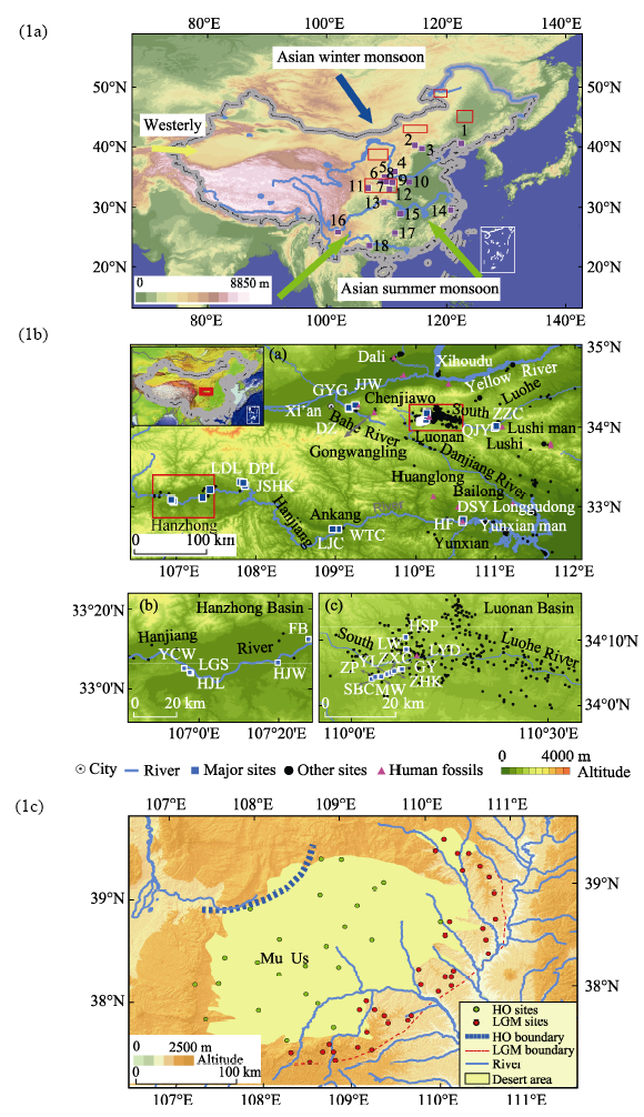
Figure 1 1a. Relief and major atmospheric circulation systems of China. Paleolithic and Neolithic archaeological sites are indicated by solid squares and the study regions mentioned in the text are indicated by hollow rectangles. Sites: 1. Jinniushan; 2. Nihewan; 3. Zhoukoudian; 4. Dingcun; 5. Dali; 6. Chenjiawo; 7. Gongwangling; 8. Luonan; 9. Lushi; 10. Lingjing; 11. Longgangsi; 12. Yunxian man; 13. Wushan; 14. Anjiang; 15. Chishandao; 16. Yuanmou; 17. Daoxian; 18. Bose.
1b. (a) Major basins, drainage patterns and Paleolithic sites in the Eastern and Central Qinling Mountains Region (QMR). (b) and (c) are enlargements of the Hanzhong and Luonan Basins. 1c. Location of Neolithic archaeological sites in the transitional zone between sand dune fields and loess deposits. Solid green circles are Holocene Optimum (HO) sites and solid red circles are Last Glacial Maximum (LGM) sites.
The unique landforms and monsoon climate of East Asia, especially in East China, provided a highly suitable habitat for early humans. Moreover, the discoveries of the remains of Peking Man (Homo erectus) at Zhoukoudian and of Nihewan Paleolithic artifacts in the 1920s in northern China (Black, 1932; Xie et al., 2006), were one of the most important events in the exploration of early human history in the 20th century. The earliest evidence of human presence is probably at Nihewan (Hebei Province), an area of lacustrine and fluvial landforms in northern-central China, and is dated to 1.7-1.6 Ma BP (Zhu et al., 2004, 2008). This robustly-dated evidence indicates that these earliest hominins were probably hunter-gatherers, who used simple Oldowan stone tools such as cores, flakes and other lithic artifacts (Xie et al., 2006). After the discovery of Nihewan early man, several excavated sites with human remains and lithic artifacts were found. This well-dated evidence includes Lantian Man (~1.2 Ma BP), Yunxian Man (~0.8 Ma BP), the Chenjiawo mandible (~0.65 Ma BP), as well as Dingcun Man, Dali Man and Lushi Man (0.3-0.15 Ma BP). These sites are all in and around the Qinling Mountains (Figure 1). Recently, several late Pleistocene human fossils have been found (Liu et al., 2015; Li et al., 2017), although the dating results are debated. Moreover, the controversial finds of Wushan Man (Huang et al., 1995), Yuanmu Man (Gao, 2015) and the Bose Handaxe assemblage (Wang et al., 2014), are not discussed in this paper.
In addition to these findings, hundreds of thousands Paleolithic artifacts have been collected in monsoonal China (Wang S, 2005; Gao et al., 2016; Wang and Lu, 2016). Over the past 30 years, our research group has collected more than 200,000 lithic artifacts in the Eastern and Central Qinling Mountains Region (QMR) (Wang S, 2005; Wang et al., 2008, 2014; 2015, 2016; Lu et al., 2007, 2011a, 2012; Sun et al., 2012, 2017; Zhuo et al., 2016; Zhuo, 2017, unpublished PhD thesis), and several phases of human occupation were documented (Lu et al., 2007, 2011b, 2012; Sun et al., 2017). The lithic artifacts are densely distributed in the watersheds of the South Luohe River, Hanjiang River and Bahe River (Figure 1c).
In addition, there are a large number of Neolithic excavation sites in the monsoon-dominated region, revealing that human behavior was closely associated with earth surface process and environmental change, particularly in ecologically- sensitive areas such as the transitional zone between desert and loess in North China. We have systematically investigated this area to explore the relationship between human behavior and landform processes and environmental change in the recent geological past (Zhuo et al., 2013; Lu et al., 2013) (Figure 1).
The dense distribution of Paleolithic and Neolithic sites in monsoonal China, which yield important information about human behavior in the Pleistocene and Holocene, are associated with changes in fluvial and aeolian landforms on multiple timescales. Therefore, the region provides an excellent testing ground for examining the relationship between geomorphological processes and human behavior, which hitherto has been largely undocumented in East Asia.

2 Landform evolution and changes in monsoon climate

There are major river catchments, mountain-basin systems, the Loess Plateau, dune fields and large alluvial basins and river deltas in eastern and central China, where vegetation growth is sustained by monsoonal precipitation and the fertile soils. The landforms developed much earlier than the timing of early human arrivals. For example, the Qinling Mountains, which are one of the most important biogeographic barriers between South and North China, were formed prior to the early Paleocene (Meng, 2017). However, the topography of the Qinling Mountains was still changing during the late early Pleistocene to Holocene, coinciding with the arrival and occupation of early humans in the area.
The global cooling of the early Pleistocene was accompanied by the growth of ice sheets in the high-latitude Northern Hemisphere, the lowering of sea level and strengthening continentality. At the same time, East Asia became drier because the lower temperatures weakened atmospheric circulation and moisture exchange (Lu et al., 2010). Against this background, the Asian summer and winter monsoon systems were established, and the intensified East Asian winter monsoon transported increased quantities of dust that was deposited in central and northern China, on various landform surfaces, especially on the Chinese Loess Plateau. Aeolian loess deposition resulted in the formation of a major landscape type which was traversed and occupied by Pleistocene hominins. In addition, the loess sediments mantled the fluvial terraces and mountain tops, with thicknesses of several tens to more than three hundred meters. Continuous loess-paleosol sequences are associated with these loess tableland landforms, and they provide excellent archives for reconstructing past climatic and environmental changes (Lu et al., 1999, 2004), as well as enabling the dating of the early human relics (Lu et al., 2007, 2011a, 2012). Since loess sediments are fragile and susceptible to erosion, the development of the numerous gullies and cliffs associated with the loess landforms may have impacted early human migration patterns and behavior.
The monsoon rainfall water is transported to the sea via a hierarchical network of channels in which gullies, tributaries and rivers are composed of the major fluvial systems. Tectonic uplift in East China during the Pleistocene was less than several tens of meters over most of the region, and therefore the formation of the river terraces was driven mainly by surface erosion and channel migration. The oldest investigated river terraces are ~2.0 Ma BP, but the hominin occupation is dated to as early as ~1.2 Ma BP (An and Ho, 1989; Sun et al., 2017) (Figure 3). Over the past ~1.2 Ma BP, more than five river terraces were formed with diverse ages, ranging from early Pleistocene to Holocene. Most of the terraces are in fluvial basins, but some are in broad river channels. Formation of the fluvial terrace sequences was mainly driven by erosion and minor local surface uplift, indicating that local tectonic activity and bedrock erosion may have controlled terrace formation, modulated by climate change.
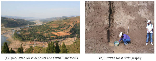
Figure 2 Examples of loess landforms and stratigraphy in the Luoshi and Luonan Basins, QMR, central China
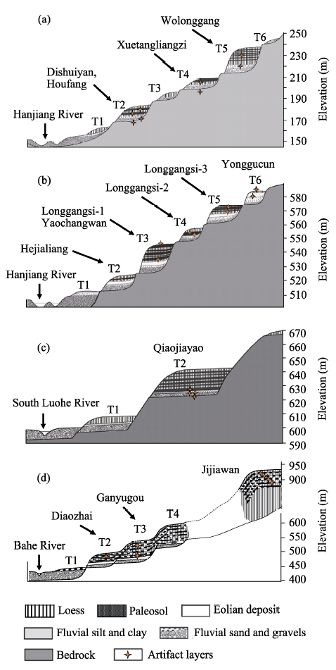
Figure 3 Landforms and fluvial terraces of the Hanjiang River, South Luohe River, and Bahe River, QMR, central China (a. Yunxian site; b. Longgangsi site; c. Qiaojiayao site; d. Diaozai site)
Long-term fluvial erosion was controlled by alternations in monsoon strength, and channel migration. The Hanjiang River flows through basins and gorges, same as the South Luohe River; however, the Bahe River originates from mountains and flows out into the Guanzhong Basin, and landforms resembling those of the two river systems to the south and southeast are absent due to its much shorter length (Figure 1). River terrace sequences are mainly developed in basins, such as the Hanzhong, Ankang, Yunxian and Shiyan Basins along the Hanjiang River; and the Luonan, Lushi, Luoning and Yiyang Basins along the South Luohe River (Figures 1 and 2). The structure of the fluvial terraces comprises bedrock at the base, followed sequentially upwards by fluvial pebbles and loess-paleosol deposits (Figure 3). Due to its ability to yield precise ages, the loess deposits can provide reliable constraints on the timing of the formation of the river terraces, as well as the ages of the Paleolithic artifact assemblages, which are scattered on the fluvial terrace surfaces and buried in the loess deposits. There are height differences of more than 400 m between the investigated terraces, and the artifacts buried therein reveal that the patterns of early human migration followed the patterns of terrace evolution.
Landform evolution also occurred on a shorter time scale. In the transitional zone between sand dune fields and loess deposits, within which the climate varies from arid to semiarid,the waxing and waning of the monsoon during the past ~20 ka has resulted in significant migration of the boundary. Essentially, a strengthened summer monsoon delivered more rainfall to the dune fields, where water was the critical limiting factor for plant growth. The increased rainfall in turn resulted in a denser vegetation coverage, the sand dunes were stabilized, and fertile soils developed. At the same time, the rivers, lakes and swamps expanded, providing a favorable environment for early humans. On the other hand, a weakened summer monsoon circulation provided insufficient water to maintain the vegetation coverage, resulting in dune mobility and a dusty environment. Under this scenario, alternations in monsoon circulation clearly controlled earth surface processes and modulated the environment of early humans. As the climate became more arid, dune fields such as the Mus Us underwent large-scale expansion and contraction (Figure 4; Lu et al., 2013; Xu et al., 2013), resulting in shifts of biogeographic boundaries of 200-300 km. Similar changes occurred in the sand dune fields of the Otindag (Zhou et al., 2013), Horqin (Yi et al., 2013) and Hulun Bier (Zeng et al., 2013). The shorelines of paleolakes would have shifted along with the changes in monsoon precipitation and lake levels (Jiang Mengyao, 2017. Personal communication). This was significant for early humans since they probably migrated in response to the lake shoreline changes. In the Nihewan Basin, the region with the earliest evidence of human occupation in East Asia, excavations have discovered lithic tools buried in lake sediments. This can be interpreted as evidence of lake transgression under increased summer monsoon precipitation. Therefore, lake expansion and contraction, resulting from changes in summer monsoon intensity, and the accompanying changes in lake shorelines, may have significantly impacted the environment of early humans. Since ~1.7 Ma BP, more than 130-m lake sediments have accumulated, with an area of ~1800 km2 (Zhu et al., 2004; Xie et al., 2006). This clearly demonstrates the occurrence of significant changes in lacustrine landforms in the Pleistocene.
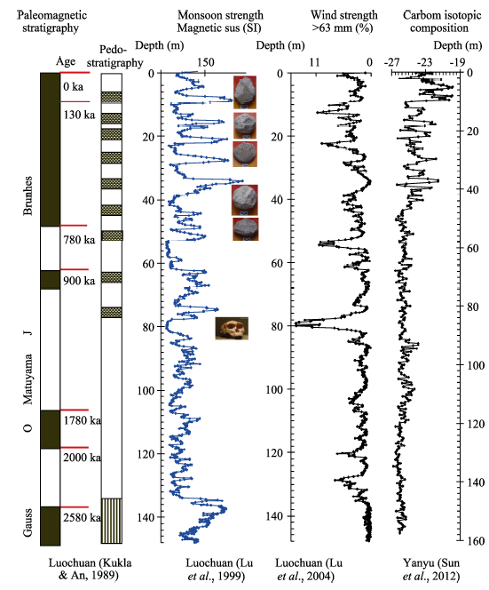
Figure 4 Stratigraphy and paleoenvironmental records from the Chinese Loess Plateau spanning the last 2 Ma. From left to right: geomagnetic polarity time scale; pedostratigraphy of the loess-paleosol sequence; magnetic susceptibility record of the Luochuan site, reflecting variations in summer monsoon strength; grain-size record from Luochuan, reflecting winter monsoon strength; stable carbon isotopic composition from the Yanyu site, reflecting vegetation patterns. The major climatic trends and cyclicity are linked with the evolution of the behavior of early humans.
Thus, variations in the monsoonal climate have significantly shaped the landforms occupied by early humans in central and northern China since the early Pleistocene, including fluvial incision, modulation of the area of dune fields, and changing the position of lake shorelines. The driving force behind these changes in earth surface processes and the resulting landforms was the fluctuating monsoonal climate. Fortunately, the Chinese loess-paleosol sequences, which provide a unique record of changes in the monsoon climate and the associated vegetation, also yield direct evidence of early human occupation and behavior. Notable among the proxy climatic indicators applied to loess deposits are the magnetic susceptibility which reflects summer monsoon precipitation; the stable carbon isotopic composition which reflects vegetation composition, specifically changes in the relative coverage of woodland and grassland; and the sediment grain-size distribution which reflects the winter monsoon strength and the area of mobile dune fields (Lu et al., 2004; Sun Jimin et al., 2012). Fluctuations in precipitation, temperature, wind strength and vegetation since the early Pleistocene are illustrated in Figure 4.

3 Human behavior during the Pleistocene and Holocene: evidence from the QMR region and dune fields

To date, we have collected more than 200,000 lithic artifacts from the QMR region. These findings indicate that early humans occupied the river terraces of the South Luohe River, Hanjiang River and Bahe River for a very long interval of time (Figure 4). They arrived in the QMR region, in both the north and south, and may have occupied the area semi-continuously until the last few tens of ka, probably with several phases of intensive activity (An and Ho, 1989; Lu et al., 2007, 2011a, b; 2012; Wang S J et al., 2005, 2008, 2014, 2016; Zhuo et al., 2016; Sun et al., 2012, 2013, 2017). The sites of early human settlement are located on river terraces within the range of several meters to hundred meters above the river water level, revealing that the humans moved across a large area. During several phases of occupation there are linkages between the southern and northern QMR; for example, at ~1.2 Ma hominins occupied both Longgansi site in the south and Gongwangling site in the north QMR (An and Ho, 1989; Sun et al., 2017). This demonstrates that the early humans may have moved across the Qinling Mountains; this is also supported by the close similarity of the lithic tool technology at the two sites, which indicates a direct linkage. After the earliest arrival in the QMR, the early humans dispersed over a large area, with a diameter of more than 200 km. The ages of the sites are clustered within specific ranges: 800-600 ka BP, 500-400 ka BP, 400-200 ka BP, 200-100 ka BP, and the last ~50 ka (Lu et al., 2007, 2011a, b, 2012; Wang et al., 2005, 2008, 2014, Sun et al., 2012, 2017; Zhuo et al., 2016; Wang and Lu, 2016). These results clearly indicate that the Qinling Mountains, with an average altitude of ~2000 m, did not act as a barrier to the migration of humans during the early to middle Pleistocene. It appears that in the QMR the early humans moved along rivers and channels to a greater extent than was previously realized. Our observations do not support the idea that the elevation of the Qinling Mountains was lower during the early Pleistocene than it is today (Xue et al., 2004), and that populations of hominins were eventually communicated between the south and north QMR. The fluvial landforms and basins in the QMR were mainly modified by climate change during the Pleistocene, and the stepped sequence of river terraces, dated from ~2.0 Ma BP to ~0.01 Ma BP, may have provided easy access of early humans to water bodies. It suggests that as the river terraces were formed the early humans may have shifted their gathering and occupation areas to the lower terraces. This hypothesis is supported by the early human occupation sites at Longyadong Cave (Wang, 2005), Liuwan (Lu et al., 2007; Zhang et al., 2012), Qiaojiayao (Lu et al., 2011a), Hejialiang (Sun et al., 2012; Wang et al., 2014) and Longgangsi (Sun et al., 2017; Wang and Lu, 2016). Our recently excavated sites, such as Fanba (Figure 5a), Duanping (Figure 5b), Jinshui (Figure 5c) and Longgangsi (Figure 5d), share the same features. We have found numerous lithic artifact assemblages at these sites (Figure 5e, 5f), indicating that the early humans moved in response to changes in the location of water bodies under specific landform constraints.
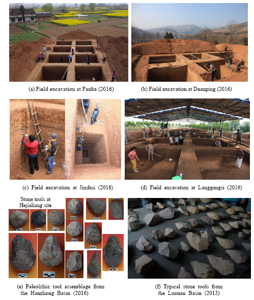
Figure 5 Recent archaeological findings in the QMR, central China
We have discovered numerous early human occupation sites in various fluvial terraces along the QMR, which are always located in medium-sized intermontane basins and small hills with an approximate diameter of several tens kilometers and elevation of several hundred meters. However, no early human sites have been found in the great plains and alluvial fans; nor have early human remains been found in great loess tableland, such as in the Guanzhong Basin and the Bailuyuan and Luochuan loess tablelands. These observations shed light on the attraction of fluvial landforms for the early humans; in addition, the discoveries indicate that they could move from the upper to the lower branches along a river, over distances of 100-300 km.
Other important Paleolithic sites are distributed along river terraces, such as those that yielded remains of Peking Man, Yunxian Man, Dali Man, and Dingcun Man; sites such as in Bose Basin; the recently discovered site of Chishandao, near Yuanjiang city, Hunan Province in South China; and the site at Anjiang, Shengzhou city, Zhejiang Province, in Southeast China. In addition, the famous Nihewan sites such as Dongutuo and Xiaochangliang are located close to lakes, indicating that landforms close to water bodies were the favored locations of early human occupations. Ease of access to water resources was probably the most important factor determining the location of the occupations sites, despite the ability of the early humans to move across a large area.
Even in the very recent geological past, the archaeological sites indicate that the location of occupation sites was closely associated with landform evolution (Zhuo et al., 2013; Lu et al., 2013; Jia et al., 2016, 2017), we therefore speculate that changes in earth surface processes, which influenced vegetation patterns and soil formation, must have impacted human behavior. In the sand dune fields, human relics dating to the Last Glacial Maximum (LGM, ~21 ka BP) are relatively rare, but those dating to the Holocene Optimum (HO, 8-5 ka BP) are common (Figure 1c). The sparsity of human sites during the LGM reflects the climatic aridity which resulted in the desiccation of rivers and lakes and the consequent reduced availability of water resources. On the other hand, the increased monsoon precipitation during the HO resulted in plentiful water resources, enabling the growth of larger vegetation cover and denser populations in the dune fields (Lu et al., 2013). Therefore, patterns of human behavior and settlement were directly determined by earth surface processes on orbital to millennial timescales.

4 Adaptation of the behavior of early humans to landform evolution

The populations of early humans may have been replaced by, or intermingled with, migrants. Our new observations shed light on specific landforms and patterns of climate change that together impacted human behavior, as reflected in the occupation sites, movement, reproduction, and prosperity of the populations. Three observations can be made. Firstly, it appears that Northwest China was too dry to have been inhabited by early humans and no early human sites have been found so far. It is possible that early human sites may yet be found in Northwest China. In addition, occupation of the Tibetan Plateau would have been a major challenge for the early humans, because of its cold climate. However, recent discoveries indicate that that humans may have perennially occupied in the Tibetan Plateau in the late Holocene against a background of technological innovation (Chen et al., 2015), may arrived in there earlier (Zhang and Li, 2002; Meyer et al., 2017). Since humans could adapt to the harsh environment, it is possible that even older evidence may be found (Zhao et al., 2009). Nevertheless, clearly the timing of the occupation of the region was significantly later than the arrival of early humans in central China.
Secondly, the great loess tablelands, although densely occupied by modern people, were also an unfavorable environment for early human occupation and no relics have been discovered. The loess sediments have a poor water retention capacity and therefore the Loess Plateau is always dry even when there is moderate precipitation. In addition, we speculate that transit across the loess landforms would have been difficult, especially during intervals of high rainfall.
Thirdly, the great basins and alluvial plains, comprising a large area in the monsoonal region, may also have been unfavorable for occupation by early humans. No fossils or stone tools have been found associated with these landforms, either on the surface or buried. The reason may be the occurrence of flooding and predation by carnivores that forced the early humans to occupy the mountains and moderate-sized basins that were more secure.
Despite the great diversity of landforms in monsoonal China, our evidence indicates that in the QMR early humans chose to occupy moderate- and small-sized river valleys, paired mountain-basins and dolomite caves which provided easy access to water resources and abundant plant resources. In summary, first, low hills with moderate-sized basins and rivers were the preferred environment of early humans. Second, it was important to have a reasonable area to move across, that is, to be able to walk or run distances of several to several tens of km. Third, plentiful plant resources close to the occupation sites human settlements were required (Zhang et al., 2017). Landforms determined the local hydrology, climate, and soil development, and thus the vegetation composition, and in turn impacted human behavior (Figure 6). The vegetation and niche environments were also a determinant of early human occupation, but their specific roles need to be further investigated.
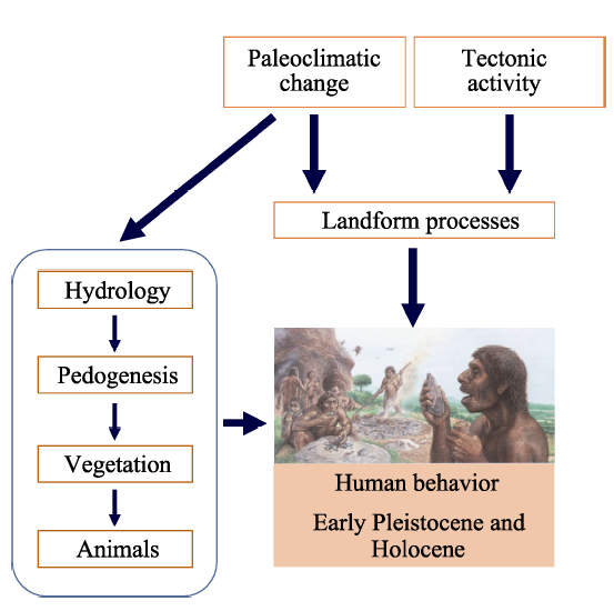
Figure 6 Early human behavior and the major influencing factors in monsoonal China. Surface processes were a major determinant of the behavior of early humans.
From the foregoing analysis, there is no doubt that earth surface processes and landforms were important constraints on the behavior of early humans in monsoonal China; moreover, rapid landform change also clearly impacted human behavior in the very recent geological past. The early humans dispersed along landforms in East Asia, they arrived in middle to small sized hills and basins in Early Pleistocene and early Middle Pleistocene, they occupied the dry areas, highlands such as desert and Tibetan Plateau in Late Pleistocene and Holocene, these evidences may show that the humans have adapted their behaviors to the harsh natural environment with stepwise forward. Overall, our observations demonstrate that landform evolution must have played an important role in modulating human behavior in East Asia during the Pleistocene and Holocene.

5 Conclusions

Our analysis of earth surface processes and the behavior of early humans in China has revealed that specific landforms played an important role in determining patterns of human behavior and the location of occupation sites during the Pleistocene and Holocene. Northwest China and the Tibetan Plateau were too arid and cold for human occupation, until the late Holocene. The oldest early human occupation sites are the Nihewan Basin, in central-northern China, dated to ~1.7 Ma BP. The subsequent occupation phases such as in the Qinling Mountains Region during the middle to late Pleistocene provide direct evidence that monsoonal China was a favorable environment for early humans. Moderate-sized rivers and basins and mountains were preferred locations and the vast open plains, basins and loess tablelands were avoided. Easy access to water resources was an important determinant of the occupation sites. Rapid landform change had the effect of driving the human migration, suggesting that earth surface processes had an important impact on early human behavior.

The authors have declared that no competing interests exist.

[1]
An Z S, Ho C K, 1989. New magnetostratigraphic dates of Lantian Homo erectus.Quaternary Research, 32: 213-221.Skeletal remains of Homo erectus found in Pleistocene loess at two sites near Lantian in central China are of greatly different geologic age. The cranium found in the fossil-bearing strata at Gongwangling is about 1.15 myr old whereas the remains found at the Chenjiawo locality in middle Pleistocene loess are about 0.65 myr old. The dating is based on new paleomagnetic polarity determinations and on the lithostratigraphic position of the fossils in the loess-paleosol sequence. Our results confirm that both localities are older than the first occupation of Zhoukoudian. New dates, palaeoenvironmental settings, and morphological features of the hominids from Lantian localities have significant bearing on the understanding of adaptive radiations of the middle and late hominids in Asia.

DOI

[2]
Black D, 1932. The discovery of Peking Man.Nature, 130(3294): 935.IN his Croonian lecture on Sinanthropus or Peking man, Prof. Davidson Black gave a full and detailed account of the circumstances leading up to the discovery of the skeletal and cultural relics of this primitive human type and of the conditions, geological and other, in which they were found.

DOI

[3]
Chen F H, Dong G H, Zhang D Jet al., 2015. Agriculture facilitated permanent human occupation of the Tibetan Plateau after 3600 B.P.Science, 347(6219): 248-250.

DOI

[4]
Gao X, 2015. On the age of Homo erectus yuanmounensis and related issues.Acta Anthropologica Sinica, 34(4): 442-450. (in Chinese)The discovery of two teeth of Homo erectus yuanmounensis from the Yuanmou Basin in Yunnan Province,South China,50 years ago is an important event in the history of research on human origins and evolution in China and East Asia.The original lithological,biostratigraphic and paleomagnetic analyses placed the human fossil-bearing stratum to the early Lower Pleistocene with an age of 1.7 Ma which has become the prevailing viewpoint in China since then.However,this estimate was challenged by some scholars and an age of 0.6-0.7 Ma for the teeth was suggested based on paleontological data and paleomagnetic re-analysis.Recent systematic paleomagnetic investigation on three sections at the site by Zhu et al.reconfirmed the age of 1.7Ma for the Yuanmou Man fossil,and this age is believed to be supported by the Lower Pleistocene mammalian assemblage associated with the human remains and with geological comparisons and correlations.However,the teeth were not excavated systematically from the site and detailed information on taphonomic association with the few unearthed artifacts is absent,which has obscured research and discussion on the age and cultural features of Homo erectus yuanmounensis.The age controversy is not an isolated case for Yuanmou Man as human skeletal remains from Salawusu in Inner Mongolia,Liujiang in Guangxi Zhuang Autonomous Region,Maba in Guangdong Province and Longgupo in Chongqi Municipality are all found to be associated with such chronological problems.Multidisciplinary research on these materials and sites and direct AMS 14 C dating on some fossils of the late Upper Pleistocene age are necessary in the future.

[5]
Guo Z T, 2017. Loess Plateau attests to the onsets of monsoon and deserts.Scientia Sinica Terrae, 47: 421-437. (in Chinese)在世界地图上, 华夏大地上的季风和荒漠可谓与众不同: 第一, 南北两半球的亚热带均以干旱环境为主(包括北非的撒哈拉沙漠、南非的纳米布沙漠、澳大利亚沙漠等),而同纬度的我国江南地区则为降水充沛的湿润季风区; 第二, 我国西北大漠与中亚干旱区连为一体, 分布的纬度比其他干旱区要高得多; 第三,虽然地球赤道两侧均为季风区, 但其他季风主要影响南北回归线之间的低纬地区, 只有东亚季风长驱直入, 不仅影响低纬地区, 而且可影响到40°N以北.我国几代科学家的研究发现, 就在不久前的地质历史时期, 华夏的季风和荒漠并非如此: 当时江南处于干旱气候的控制之下, 季风只影响我国最南部地区,在环境格局上完全与世界“接轨”. 今天特殊的东亚气候, 源于后来一系列复杂的经历; 而黄土高原正是其中渊源的一位可靠见证者. 华夏季风与荒漠不仅与华夏山水的其他成员(如青藏高原、长江、黄河、黄土高原、秦岭等)有着明确的“亲缘”关系,而且依然相互作用, 影响着我们今天的生存环境.

DOI

[6]
Guo Z T, Ruddiman W F, Hao Q Zet al., 2002. Onset of Asian desertification by 22 Myr ago inferred from loess deposits in China.Nature, 416(6877): 159-163.

DOI

[7]
Hu X M, Garzanti E, Wang J Get al., 2016. The timing of India-Asia collision onset: Facts, theories, controversies.Earth-Science Reviews, 160: 264-299.These coherent observations are hard to reconcile with three widely cited hypotheses invoking either Paleogene arc-continent collision or Late Cretaceous ophiolite obduction, or the protracted existence of a Greater India Basin, which are all not favored after discussing the geological evidence critically point by point. A scenario no more complex than the one involving solely the passive continental margin of India and the active continental margin of Asia is needed to explain the geological evolution of the nascent Himalaya. The collision between the Tethys Himalaya and the Transhimalayan arc-trench system does represent the collision between India and Asia. Because the Yarlung Zangbo ophiolite is the forearc basement of the Asian active margin, its obduction onto India could not have preceded the initial closure of Neo-Tethys. Ophiolite obduction began when collision began, in the middle Paleocene.

DOI

[8]
Huang W P, Ciochon R, Gu Y Met al., 1995. Early Homo and associated artifacts from Asia.Nature, 378(6554): 275-278.THE site of Longgupo Cave was discovered in 1984 and excavated in 1985–1988 by the Institute of Vertebrate Paleontology and Paleoanthropology (Beijing) and the Chongqing National Museum (Sichuan Province). Important finds include very archaic hominid dental fragments, Gigantopithecus teeth and primitive stone tools. Palaeomagnetic analysis and the presence of Ailuropoda microta (pygmy giant panda) suggested that the hominid-bearing levels dated to the earliest Pleistocene 1 . In 1992, joint Chinese–American–Canadian geochronological research corroborated the age using electron spin resonance (ESR) analysis. We report here that the hominid dentition and stone tools from Longgupo Cave are comparable in age and morphology with early representives of the genus Homo ( H. habilis and H. ergaster ) and the Oldowan technology in East Africa. The Longgupo dentition is demonstr-ably more primitive than that seen in Asian Homo erectus . Long-gupo's diverse and well preserved Plio-Pleistocene fauna of 116 species provide a sensitive contextual base for interpreting the early arrival of the genus Homo in Asia.

DOI PMID

[9]
Jia X, Lee H F, Zhang W Cet al., 2016. Human-environment interactions within the West Liao River Basin in northeastern China during the Holocene Optimum.Quaternary International, 428: 10-17.Cultural studies of Neolithic China have focused on the social aspects and the human–environment interactions associated with those cultures. However, the uneven spatial distribution of Neolithic sites in Northeastern China has not yet been explored. This study traces the relationship between human settlement patterns and the agro-ecological environment during the Holocene Optimum, based on the spatial distribution of 4184 Neolithic sites, together with optically stimulated luminescence (OSL) dating and pollen analysis of five profiles and 22 plant flotation samples from 10 of the archaeological sites in the West Liao River Basin, the hub of Neolithic Cultures in Northeastern China. The overwhelming majority (6596.7%) of the Neolithic sites are located south of 430230′N latitude in the West Liao River Basin on the southern fringe of the Horqin Dunefield. The dunefield, which has been commonly hypothesized as vegetated during the Holocene Optimum, was a typical steppe at that time and not suitable for growing millet, the primary staple crop of Neolithic Cultures. Our results and other archaeological site records reveal that the 43°30′N latitude was a remarkable barrier for the dispersal of human settlements in Northeastern China during the Neolithic Age. The barrier was probably formed by the low frost tolerance of millet and the temperature gradient associated with the latitude, making large-scale agricultural production impossible in the regions north of this latitude at the time. Our findings provide evidence for the natural northern limit of Neolithic Cultures in Northeastern China during the Holocene Optimum.

DOI

[10]
Jia X, Yi S W, Sun Y Get al., 2017. Spatial and temporal variations in prehistoric human settlement and their influencing factors on the south bank of the Xar Maron River, northeastern China.Frontiers of Earth Science, 11(1): 137-147.The West Liao River Basin is the hub of ancient civilizations as well as the birthplace of rain-fed agriculture in Northem China.In the present study,based on 276 archaeological sites on the south bank of the Xar Moron River,Northeastern China,we trace the changes in prehistoric cultures as well as the shifts in the spatial and temporal patterns of human settlement in the West Liao River Basin.Location information for those sites was obtained from fieldwork.Factors such as climate change,landform evolution of the Horqin Dunefield,and subsistence strategies practiced at the sites were extracted via the meta-analysis of published literature.Our results show that the Holocene Optimum promoted the emergence of Neolithic Culture on the south bank of the Xar Moron River.Monsoon failure might have caused the periodic collapse or transformation of prehistoric cultures at (6.5,4.7,3.9,and 3.0) kyr B.P,leaving spaces for new cultural types to develop after these gaps.The rise and fall of different cultures was also determined by subsistence strategies.The Xiaoheyan Culture,with mixed modes of subsistence,weakened after 4.7 kyr B.P.,whereas the Upper Xiajiadian Culture,supported by sheep breeding,expanded after 3.0 kyr B.P.Global positioning system data obtained from the archaeological sites reveal that cultures with different subsistence strategies occupied distinct geographic regions.Humans who subsisted on hunting and gathering resided at higher altitudes during the Paleolithic Age (1074 m a.s.1.).Mixed subsistence strategies led humans to settle down at 600-1000 m a.s.1.in the Neolithic Age.Agricultural activities caused humans to migrate to 400-800 m a.s.1.in the early Bronze Age,whereas livestock production shifted human activities to 800-1200 m a.s.1.in the late Bronze Age.

DOI

[11]
Li Z Y, Wu X J, Zhou L Pet al., 2017. Late Pleistocene archaic human crania from Xuchang, China.Science, 355(6328): 969-972.Abstract Two early Late Pleistocene (~105,000- to 125,000-year-old) crania from Lingjing, Xuchang, China, exhibit a morphological mosaic with differences from and similarities to their western contemporaries. They share pan-Old World trends in encephalization and in supraorbital, neurocranial vault, and nuchal gracilization. They reflect eastern Eurasian ancestry in having low, sagittally flat, and inferiorly broad neurocrania. They share occipital (suprainiac and nuchal torus) and temporal labyrinthine (semicircular canal) morphology with the Neandertals. This morphological combination reflects Pleistocene human evolutionary patterns in general biology, as well as both regional continuity and interregional population dynamics. Copyright 2017, American Association for the Advancement of Science.

DOI PMID

[12]
Liu W, Martinon-torres M, Cai Y Jet al., 2015. The earliest unequivocally modern humans in southern China.Nature, 526: 696-699.Abstract The hominin record from southern Asia for the early Late Pleistocene epoch is scarce. Well-dated and well-preserved fossils older than 09080445,000 years that can be unequivocally attributed to Homo sapiens are lacking. Here we present evidence from the newly excavated Fuyan Cave in Daoxian (southern China). This site has provided 47 human teeth dated to more than 80,000 years old, and with an inferred maximum age of 120,000 years. The morphological and metric assessment of this sample supports its unequivocal assignment to H. sapiens. The Daoxian sample is more derived than any other anatomically modern humans, resembling middle-to-late Late Pleistocene specimens and even contemporary humans. Our study shows that fully modern morphologies were present in southern China 30,000-70,000 years earlier than in the Levant and Europe. Our data fill a chronological and geographical gap that is relevant for understanding when H. sapiens first appeared in southern Asia. The Daoxian teeth also support the hypothesis that during the same period, southern China was inhabited by more derived populations than central and northern China. This evidence is important for the study of dispersal routes of modern humans. Finally, our results are relevant to exploring the reasons for the relatively late entry of H. sapiens into Europe. Some studies have investigated how the competition with H. sapiens may have caused Neanderthals' extinction (see ref. 8 and references therein). Notably, although fully modern humans were already present in southern China at least as early as 09080480,000 years ago, there is no evidence that they entered Europe before 09080445,000 years ago. This could indicate that H. neanderthalensis was indeed an additional ecological barrier for modern humans, who could only enter Europe when the demise of Neanderthals had already started.

DOI PMID

[13]
Lu H Y, Guo Z T, 2014. Evolution of the monsoon and dry climate in East Asia during late Cenozoic: A review. Science China:Earth Sciences, 57(1): 70-79.

DOI

[14]
Lu H Y, Liu X D, Zhang F Qet al., 1999. Astronomical calibration of loess-paleosol deposits at Luochuan, central Chinese Loess Plateau. Palaeogeography, Palaeoclimatolpgy,Palaeoecology, 154: 237-246.The 140 m loess–paleosol profile at Luochuan in the central Chinese Loess Plateau was sampled at 5-cm intervals in loess units and at 3 cm in paleosol units, in order to obtain a high resolution climatic record covering the past 2.5 million years. All samples were measured for magnetic susceptibility, which is regarded as a good proxy index of the East Asian summer monsoon strength. On the basis of the astronomical theory of Pleistocene climatic change, an age model of the Luochuan loess–paleosol sequence was developed by tuning the magnetic susceptibility record to time-series of insolation changes. The results show that the ages of the boundaries between the Malan and Lishi, and Lishi and Wucheng loess formations are 71 and 1320 kyr BP, respectively. The onset of loess accumulation is at 2470 kyr BP. Our age model was tested by comparing the orbitally derived ages with absolute age determinations of magnetic reversals, and cross-spectrum analyzing with solar radiation variations for summer at 65°N. These indicate that the calibration provides a reliable time scale for the Luochuan loess–paleosol deposit.

DOI

[15]
Lu H Y, Sun X F, Wang S Jet al., 2011a. Ages for hominid occupation in Lushi Basin, middle of South Luohe River, central China.Journal of Human Evolution, 60: 612-617.A newly discovered Paleolithic site in loess deposits in the Lushi Basin, South Luo River, central China, is dated using pedostratigraphic analysis, optically stimulated luminescence (OSL) and magnetostratigraphic analysis. This region is regarded as an important place for hominin occupation and settlement during the early to middle Pleistocene. Results indicate that the archaeological site dates from 600 ka to 620 ka, reinforcing the view that Homo erectus had occupied a large area of eastern Asia by 620 ka. The lithic assemblages of Lushi Basin is a flake and core technology, typical for this time period in north-central China. It may be compared with that at the Zhoukoudian locality 1 in north China and some sites in the Luonan Basin, and provides important data for understanding the behavior and stone tool technology of early Chinese hominins.

DOI PMID

[16]
Lu H Y, Wang X Y, Li L P, 2010. Aeolian sediment evidence that global cooling has driven late Cenozoic stepwise aridification in central Asia. Geological Society,London: Special Publications, 342: 29-44.

DOI

[17]
Lu H Y, Yi S W, Xu Z Wet al., 2013. Chinese deserts and sand fields in Last Glacial Maximum and Holocene Optimum.Chinese Science Bulletin, 58(33): 2775-2783.最后冰川的最大值(LGM, c。26-16 ka ) 并且 Holocene 最佳(惊讶, c。9-5 ka ) 被寒冷干燥、温暖湿的气候在最近地质的地球中分别地描绘。中国沙漠和沙地怎么对这些特殊气候的变化作出回应,仍然不然而是清楚的。重建沙漠和沙地的环境在 LGM 期间并且惊讶是有用的理解环境的强迫的机制在这个干旱区域变化,并且测试为结果建模的 paleoclimatic。通过我们的长期的地和实验室调查, 400 光学地刺激的光(OSL ) 变老,超过 100 depositional 在中国沙漠和沙地记录被获得;根据这些数据,我们重建沙漠和沙域的空间分布在 LGM 期间并且惊讶。我们沙亩回答的结果表演我们, Hunshandake, Horqin 和 Hulun 分别地,在北、东北的中国的 Buir 在 LGM 期间扩展了 25% , 37% , 38% 和 270% ;在东北 Qinghai 西藏的高原的 Gonghe 的沙地扩展了 20% ,并且 Badain Jaran 的沙漠,在中央北中国的 Tengger 在 LGM 期间独立扩展了 39% 和 29% ;Taklimakan 的沙漠, Gurbant 慧整 ? 敫瑰甠据慨杮摥甠瑮汩愠湮慥楬杮映牯 ?‰業n

DOI

[18]
Lu H Y, Zhang F Q, Liu X Det al., 2004. Periodicities of palaeoclimatic variations recorded by loess-paleosol sequence in China.Quaternary Science Reviews, 23(18/19): 1891-1900.Palaeoclimatic periodicity recorded by Chinese loess-paleosol sequence has been investigated for a number of years. However, conclusions from previous investigations are still controversial, and interpretation of cycle evolution is quite equivocal. In this study, two typical loess-paleosol sequences (148 and 191 m in thickness, respectively) in the central Chinese Loess Plateau are sampled (3872 samples total) and measured for grain size distribution and magnetic susceptibility in order to reconstruct the palaeoclimatic changes over the past three million years. On the basis of a new, sensitive proxy indicator of palaeoclimate and a newly developed independent time scale (not orbitally-tuned), two time series of Asian dust storm variations, which are highly related to the palaeoclimate system changes, are obtained. Wavelet and spectrum analyses indicate that there are approximately 400, 200, 100, 66, 57, 41, 31, 27 and 22 kyr cycles in these typical loess-paleosol records. Some orbital-driven cycles are weak and are not well presented in the new time series while some non-orbital cycles are found. Since the eccentricity frequencies of the solar irradiance of approximately 400 and 100 kyr are preserved in these palaeoclimatic sequences, the lack of relatively short-time orbital cycles of 41-kyr-obliquity and 22-kyr-precession cycles in part of the two time series may be explained by the relatively low time-resolution of the loess-paleosol deposits. Through an astronomical estimate, the obliquity and precession cycles should leave stronger footprints on records of palaeoclimatic variations at the middle latitudes of the northern hemisphere. The presence of non-orbital cycles may be explained by unstable dust deposition processes and pedogenic processes in the paleosol units, which could misrepresent or obliterate the imprint of the solar irradiance frequency. This conclusion may indicate that one should be cautious when investigating specific palaeoclimatic changes (e.g., at sub-orbital time scales) recorded in loess deposits, especially in the paleosol units.

DOI

[19]
Lu H Y, Zhang H Y, Sun X Fet al., 2012. Landform, loess deposit and palaeoenvironmental changes in the South Luohe River (central China) during the hominin occupations.Quaternary Sciences, 32: 167-177. (in Chinese)Over the past 20 years,more than 300 Paleolithic sites have been found in catchment of South Luohe River,Central China.This river is located at the environmental boundary between North and South China.To its south, climate is characterized by the subtropical monsoon; to the north,it is a warm temperate climate.Many lithic artifacts are scattered on the surface of various landforms and buried in aeolian loess deposits and cave sediments.The Paleolithic artifacts are made up of chopper-chopping(Mode 1)assemblages such as cores,flakes,choppers,scrapers and points and Acheulian-like large-cutting tools(Mode 2)such as hand-axes,cleavers,trihedrals,knives.The region contains both small tools reminiscent of North China and biface technology produced on large pebbles characteristic of South China.It appears that early humans repeatedly occupied this region. In summer of 2004,our interdisciplinary team was set up and field exploration focussed on different landforms,particularly loess deposits that reflected past environmental changes, was undertaken.Eight archaeological sites were excavated,and sediment samples were taken from 14 loess-paleosol sections.Over 20000 lithic artefacts were collected and more than 10 thousand loess samples have been obtained and studied.In this paper,we discuss recent findings during 2009~2011 on understanding landform evolution,the loess-paleosol record,paleoenvironmental reconstruction and relationship between hominines behavior and these landforms.The results show that the landforms of the South Luohe River can be divided into two parts: the upper part is characterized by mountains and intermountain basins,with gorges and narrow rivers,where the channel gradient ratio is greater and the river current is relatively swift.The lower part is characterised by a piedmont plain with a smaller stream channel gradient ratio,where the river is braided with relatively slow flowing water.There is an extensive loess cover in this catchment,and its features are controlled by landform and local wind.The loess thickness is 2~25m in the upper part,to 30~90m in the middle and lower parts,with clear loess-paleosol alternations. The loess deposits are dated from the ca.1100ka to 30ka.We have used the loess chronology to age the stone artifacts buried in their layers.The results show that hominines have occupied this catchment for at least 800ka to 30ka,with several episodes of relative intensive human activity.Preliminary investigations on past environmental changes and hominine responses to them show that: 1)landforms along the South Luohe River were relatively stable during Pleistocene,because the mountains and intermountain basins were formed before the hominines occupied this region.Stone tools are found bothand scattered across these landforms surfaces reaching altitudes of 600m.2)a very preliminary spore-pollen analyses show that tree pollen was 25.3%~28.2% and grass pollen was 64.5%~71.4% during the glacial periods; it changed to 47.0%~54.7% and 34.9%~40.3% respectively during the interglacial period,withand dominated the forest.The vegetation probably provided a wealth of food resources for early humans who adapted to the paleoclimate changes during these time periods.Our preliminary investigation shows that the South Luohe River is an important region for investigating early human behaviors and changing environments during Pleistocene.More detailed research works are needed to advance our understanding of the interplay between climate,human adaptation and technology during the Middle Paleolithic period of China.

DOI

[20]
Lu H Y, Zhang H Y, Wang S Jet al., 2007. A preliminary survey on loess deposit in eastern Qinling Mountains (central China) and its implication for estimating age of the Pleistocene lithic artifacts.Quaternary Sciences, 27(4): 559-567. (in Chinese)A large number of lithic artifacts of Pleistocene age have been collected from the Luonan Basin, located in the Eastern Qinling Mountains (Central China) over the past ten years. This area is regarded as one of the most important places for understanding hominid behavior in the recent geological time. However, the lack of suitable dating material and sedimentary records has restricted our investigation of human evolution, behavior, and environmental changes. The Luonan Basin and the South Luohe River catchment contain typical loess sequences, in which lithic artifacts are buried. These deposits can be well dated and used as a proxy record of past environmental change. The loess sequence provides a secure time-scale for dating the associated artifacts, and they also provide a basis for climatic and environmental reconstruction as a background to past human settlement. In this study two loess sections, one located in Shangbaichuan with a thickness of 24.8 meters, and the other in Liuwan with a thickness of 13 meters, have been investigated by an interdisciplinary research team. Our results show that these loess deposits are aeolian in origin with strong weathering process. The loess-paleosol alternations are related with the glacial-interglacial changes of the Northern Hemisphere environment during the Pleistocene. Analyses of the stratigraphy and depositional processes, plus optically stimulated luminescence dating, palaeomagnetic stratigraphic analyses, as well as magnetic susceptibility measurements show that the loess deposit in this region started accumulating at least 1.10 million years ago. There are clear warm/cold and humid/arid alternating phases indicated by loess and paleosol sequences in the Eastern Qinling Mountains during this time. The discovery of lithic artifacts in the lower parts of the loess indicate that early hominids were living in this region at least 0.8 million years ago. The hand-axes and cleavers found in this region indicate that Mode 2 Acheulian tools were distributed beyond the "Movius line" in Eastern Asia. However, more survey and systematic excavation is needed to further understand human evolution, technological behaviors, and environmental changes in this important geographic transition zone in Central China.

DOI

[21]
Lu H Y, Zhang H Y, Wang S Jet al., 2011b. Multiphase timing of hominin occupations and the paleoenvironment in Luonan Basin, central China.Quaternary Research, 76: 142-147.Thousands of Paleolithic artifacts have been recovered from Paleolithic sites in the Luonan Basin, in the upper South Luohe River of central China. Their discovery suggests that the basin was an important area for hominin settlement during the Pleistocene. However, the initial timing of this occupation and the environmental conditions for this period are still largely unknown. In addition, the sediments are not well dated and most of the artifacts lie on the surface. In an attempt to resolve these issues, a new systemic paleomagnetic analysis was carried out on the loess deposits that contain in situ stone tools. Our detailed loess090009paleosol analyses of the stratigraphy of different sites in the basin and Chinese Loess Plateau shows the accumulation of the loess since at least 1.1 million years (Ma) ago. Moreover, recently discovered in situ cores, flakes and retouched stone tools in these deposits show that hominins used this region repeatedly from 0.80900090.7 Ma to 0.40900090.3 and 0.20900090.1 Ma. Pedostratigraphic analyses, magnetic susceptibility and carbon isotope analyses also indicate that these hominins lived in a subtropical to warm-temperate climate with broad-needle-leaf forest vegetation mixed with grasses.

DOI

[22]
Manabe S, Broccoli A J, 1990. Mountains and arid climates of middle latitudes.Science, 247(4939): 192-195.Simulations from a global climate model with and without orography have been used to investigate the role of mountains in maintaining extensive arid climates in middle latitudes of the Northern Hemisphere. Dry climates similar to those observed were simulated over central Asia and western interior North America in the experiment with mountains, whereas relatively moist climates were simulated in these areas in the absence of orography. The experiments suggest that these interior regions are dry because general subsidence and relatively infrequent storm development occur upstream of orographically induced stationary wave troughs. Downstream of these troughs, precipitation-bearing storms develop frequently in association with strong jet streams. In contrast, both atmospheric circulation and precipitation were more zonally symmetric in the experiment without mountains. In addition, orography reduces the moisture transport into the continental interiors from nearby oceanic sources. The relative soil wetness of these regions in the experiment without mountains is consistent with paleoclimatic evidence of less aridity during the late Tertiary, before substantial uplift of the Rocky Mountains and Tibetan Plateau is believed to have occurred.

DOI PMID

[23]
Meng Q R, 2017. Origin of the Qinling Mountains.Scientia Sinica Terrae, 47: 412-420. (in Chinese)

DOI

[24]
Meyer M C, Aldenderfer M S, Wang Zet al., 2017. Permanent human occupation of the central Tibetan Plateau in the early Holocene.Science, 355(6320): 64-67.Current models of the peopling of the higher-elevation zones of the Tibetan Plateau postulate that permanent occupation could only have been facilitated by an agricultural lifeway at ~3.6 thousand calibrated carbon-14 years before present. Here we report a reanalysis of the chronology of the Chusang site, located on the central Tibetan Plateau at an elevation of ~4270 meters above sea level. The minimum age of the site is fixed at ~7.4 thousand years (thorium-230/uranium dating), with a maximum age between ~8.20 and 12.67 thousand calibrated carbon-14 years before present (carbon-14 assays). Travel cost modeling and archaeological data suggest that the site was part of an annual, permanent, preagricultural occupation of the central plateau. These findings challenge current models of the occupation of the Tibetan Plateau. Authors: M. C. Meyer, M. S. Aldenderfer, Z. Wang, D. L. Hoffmann, J. A. Dahl, D. Degering, W. R. Haas, F. Schl tz

DOI PMID

[25]
Molnar P, Boos W R, Battisti D S, 2010. Orographic controls on climate and paleoclimate of Asia: Thermal and mechanical roles for the Tibetan Plateau.Annual Review of Earth & Planetary Sciences, 38(1): 77-102.Prevailing opinion assigns the Tibetan Plateau a crucial role in shaping Asian climate, primarily by heating of the atmosphere over Tibet during spring and summer. Accordingly, the growth of the plateau in geologic time should have written a signature on Asian paleoclimate. Recent work on Asian climate, however, challenges some of these views. The high Tibetan Plateau may affect the South Asian monsoon less by heating the overlying atmosphere than by simply acting as an obstacle to southward flow of cool, dry air. The East Asian “monsoon” seems to share little in common with most monsoons, and its dynamics may be affected most by Tibet's lying in the path of the subtropical jet stream. Although the growing plateau surely altered Asian climate during Cenozoic time, the emerging view of its role in present-day climate opens new challenges for interpreting observations of both paleoclimate and modern climate.

DOI

[26]
Sun J M, Lü T Y, Zhang Z Qet al., 2012. Stepwise expansions of C4 biomass and enhanced seasonal precipitation and regional aridity during the Quaternary on the southern Chinese Loess Plateau.Quaternary Science Reviews, 34: 57-65.正The expansion of C_4 plants is one of the most prominent vegetation changes in the global ecosystem during the Cenozoic Era.Although C_4 plant expansions in the latest Miocene have been widely reported,factors driving the expansions are still in debate,and the details of vegetation changes during the Quaternary have not been well studied.Here we present high-resolution carbon isotope time series of both organic matter and bulk carbonates,covering the past 2.58 Ma,derived from the loess-soil successions on the southern Chinese Loess Plateau.The organic matterδ~(13)C values indicate stepwise C_4 plant expansions initiated at~1.6 and at~0.43 Ma,respectively.We conclude that such tectonic time scale C_4 plant expansions are controlled by enhanced seasonality of precipitation(relatively more precipitation in the warm growing season) as well as regional aridity,and this long-term fluctuation superimposes on the orbital scale variations of C_4 plants,while the latter appears phase-locked with cyclical changes of summer monsoon circulations.

DOI

[27]
Sun X F, Lu H Y, Wang S Jet al., 2012. Ages of Liangshan Paleolithic sections in Hanzhong Basin, central China.Quaternary Geochronology, 10: 380-386.Thermally transferred optically stimulated luminescence (TT-OSL) dating extends the age range beyond current limits of OSL dating in Chinese loess. In this study, we use a single-aliquot regenerative-dose procedure for TT-OSL protocol to date Yaochangwan and Hejialiang localities of loess-covered Liangshan Paleolithic sites in Hanzhong Basin, which is an important area for the study of Paleolithic industries during the middle Pleistocene in central China. The results suggest that buried culture layer at the Hejialiang locality is correlated with the last interglacial paleosol S1 in Chinese Loess Plateau, it is dated at 86.3±6.4ka. The Yaochangwan locality spans from approximate 600–100ka and correlates with S5–S1 in the typical Chinese loess–paleosol sequences, respectively. These ages suggest that hominins already occupied the Hanzhong Basin since approximately 600ka ago.

DOI

[28]
Sun X F, Lu H Y, Wang S Jet al., 2013. TT-OSL dating of Longyadong Middle Paleolithic site and paleoenvironmental implications for hominin occupation in Luonan Basin (central China).Quaternary Research, 79: 168-174.Dating middle Pleistocene hominin occupations alongside the reconstruction of paleoenvironments in China between 700 and 100 ka has always been a challenging task. In this paper, we report thermally transferred optically stimulated luminescence (TT-OSL) dating results for a Middle Paleolithic site in the Luonan Basin, central China, which we have named Longyadong Cave. The results suggest that the age of cave infilling and the deposition of sediments outside the cave range between 389 u00b1 18 and 274 u00b1 14 ka. These deposits are stratigraphically and geochronologically correlated with the L4 loess and S3 paleosol units of the typical loessu2013paleosol sequence of the Chinese Loess Plateau, and with Marine Isotope Stages (MIS) 10 to 9, respectively. On the basis of these new ages and the available paleoenvironmental data, it is suggested that the Longyadong hominins might have occupied the site both in glacial and interglacial periods, demonstrating that they coped well with environmental change in this mountainous region in warm/wet and cold/dry climates. The study further implies that the hominins abandoned the Longyadong Cave between 274 u00b1 14 and 205 u00b1 19 ka, when it was sealed by alluvial and slope deposits.

DOI

[29]
Sun X F, Lu H Y, Wang S Jet al., 2017. Early human settlements in the southern Qinling Mountains, central China.Quaternary Science Reviews, 164: 168-186.China is a key area of early human settlement in East Asia, with numerous Paleolithic localities indicating an early Pleistocene presence of hominins in northern and southern China. Considerable research has been devoted to determining possible migration routes for hominins linking the two areas. In this paper, we report the discovery of several loess-covered Paleolithic sites in the Hanzhong and Ankang Basins along the Hanjiang River in the southern piedmont of the Qinling Mountains (QLM) in central China. A chronology is developed for these sections using a combination of detailed optically stimulated luminescence dating, magnetostratigraphic analyses, and pedostratigraphic correlation with the well-dated loess–paleosol sequence of the central Chinese Loess Plateau. The results indicate that the age of the oldest lithic assemblage at the Longgangsi locality 3 Paleolithic site in Hanzhong Basin is 651.20Ma, thus making this locality as one of the oldest sites in central China. Our work also indicates that hominins occupied the Hanjiang valley at several times: 651.2, 0.9, 650.6, and 650.1Ma. We propose that the Hanjiang River Valley was a probable hominin routeway through the QLM because many sites corresponding to these different phases were also discovered to the north of the QLM. Future study on the Hanjiang River Valley is important for verifying the hypothesis of an early human migration route between southern and northern China.

DOI

[30]
Sun X J, Wang P X, 2005. How old is the Asian monsoon system? Palaeobotanical records from China. Palaeogeography, Palaeoclimatology,Palaeoecology, 222(3/4): 181-222.The recent discovery of monsoon records in early Miocene raised a question of the time when the East Asian monsoon system initiated. A distinguishing feature of the modem monsoon system is its geographic distribution which disturbs the zonal pattern indigenous to the planetary climate system, and the appearance of the monsoonal climate pattern in the geological records should signify the onset of the monsoon system. Here we present the results of a compilation of palaeobotanical and lithological data from 125 sites over China, that has revealed two completely different patterns of climate zones: the Palaeogene pattern with a broad belt of aridity stretched across China from west to east, and the Neogene pattern with the and zone restricted to northwest of China which has persisted until today. The reorganization of the climate system around the Oligocene/Miocene boundary provides evidence for the establishment of the modem East Asian monsoon. Since then, the Neogene has witnessed significant variations of the monsoon system, including enhancement of aridity and monsoon intensity at about 15-13 My, around 8 My and 3 My. The new data do not support the onset of the Asian monsoon system around 8 My. Rather, the new data led to a hypothesis that the transition to the monsoon climate system in East Asia occurred in the latest Oligocene. (c) 2005 Elsevier B.V. All rights reserved.

DOI

[31]
Wang S J, 2005. Perspectives on hominin behavior and settlement patterns: A study of the lower Paleolithic sections in the Luonan Basin, China. In: British Archaeological Reports International Series 1406. Oxford: Archaeopress.

[32]
Wang S J, Lu H Y, 2016. Taphonomic and paleoenvironmental issues of the Pleistocene loessic Paleolithic sites in the Qinling Mountains, central China. Science China Earth Sciences, 59: 1519-1528.Hinterland intermountain basins and northern and southern piedmonts of the Qinling Mountains accumulated a large amount of loess during the Pleistocene. The loess strata not only record local paleogeographic and paleoenvironmental changes, but also contain rich hominin fossils and Paleolithic remains. In the northern piedmont of the Qinling Mountains and the lower valley of the South Luohe River, the loess strata have multi loess-paleosol sequences with aeolian loess continuously accumulating during glacial and interglacial cycles. In contrast to the northern piedmont, loess stratigraphy in the hinterland intermountain basins of the Qinling Mountains is relatively thin and contains finer loess particles. In this ini type of loess stratum, the density of Paleolithic remain generally is higher than the Loess Plateau in the north of the Qinling Mountains. Based on stratigraphic, chronological, and lithic artifacts analysis in recent years, it appears that the regional lithic assemblage belongs to the Oldowan (Mode I) lithic industry, and it is dominated by choppers, cores, flakes, and simple retouched flake tools from 1.15 to 0.6 Ma. Paleolithic open-air sites such as Gongwangling and Chenjiawo in the Lantian area, Shangbaichuan and Liuwan in the Luonan Basin, Qiaojiayao in the Lushi Basin, Longgangsi and Yaochangwan in the Hanzhong Basin, Guanmiao in the Ankang Basin, and the Yunxian Man Site in the Yunxian Basin are representative sites in the region; from 400 to 250 ka, the Longyadong cave site in the Luonan Basin inherited the characteristics of the local Mode I lithic industry, the stone assemblage is made up of cores, flakes, and small retouched flake tools, such as scrapers, points, and burins; during the period from 250 to 50 ka, bi-facially retouched Acheulean tools (Model II), such as hand-axes, picks, and cleavers, were commonly found in the Qinling Mountains region. The emergence of a large number of Model II artifacts indicates that local lithic industries went through a major transition process. Zhanghuokou, Guoyuan, and Huaishuping sites in the Luonan Basin, Diaozhai, Ganyu, Laochihe, and Xiehu sites in the Lantian area, Hejialiang site in the Hanzhong Basin are representative sites in this period; to the turn of the Late Pleistocene and Early Holocene, it may also exist a small flake-retouched tools lithic industry in the piedmonts of the northern and southern sides of the Qinling Mountains. The lithic assemblages in different stages of the Qinling Mountains region reflect the hominin behavioral changes and the development of lithic technology during the Pleistocene.

DOI

[33]
Wang S J, Lu H Y, Zhang H Yet al., 2008. A preliminary survey of palaeolithic artifacts and loess deposition in the middle South Luohe River, eastern Qinling Mountains, central China.Quaternary Sciences, 28: 988-999. (in Chinese)对2006~2007年在东秦岭南洛河中游地区河南省卢氏和洛宁两县发现的8处旷野类型旧石器地点的160余件石制品进行了初步研究,并对产出石制品的黄土堆积剖面进行了地层学分析和光释光测年。初步结果表明,南洛河中游地区的旧石器工业很丰富,石制品的加工技术与上游洛南盆地一致,同样采取硬锤直接打击法;加工石制品的原料来自于河流堆积物中的石英岩和石英砾石等;石制品中有相当数量的小型石片和由小型石片二次加工修理而成的工具,还有直接由砾石加工而成的重型工具,如手镐等;除此之外,大型石片以及以大型石片加工而成的重型工具,如重型刮削器也多有所见。由于工作范围和力度的局限,南洛河中游地区目前尚未发现上游洛南盆地旧石器遗址中广泛存在的手斧、三棱手镐、薄刃斧和大型石刀等Acheulian类型两面加工技术生产的工具。新发现的南洛河中游旧石器地点分布在不同时期形成的河流阶地和黄土地层中。地层分析和光释光年代测试表明,南洛河中游地区的黄土堆积至少从中更新世便已经开始,并一直持续到全新世,至少在黄土剖面中S1,S3和S4的3个层位有石器分布;其黄土-古土壤旋回不仅可以用于石制品产出层位的准确定年,还指示了早期人类石器工业演化和人类生存环境变化的过程。

DOI

[34]
Wang S J, Lu H Y, Zhang H Yet al., 2014a. Newly discovered palaeolithic artifacts from loess deposits and their ages in Lantian, central China.Chinese Science Bulletin, 59(7): 651-661.八新 Palaeolithic 露天地点被识别, 770 石头人工品在 Bahe 河山谷的 Lantian 区域从 2009 ~ 2011 是镇定的,华中。因为著名直立人石块在 Gongwangling 和 Chenjiawo 地区,和超过 30 Palaeolithic 被发掘露天地点在这个区域在 1960 年代被调查, Bahe 河的集水从晚早的更新世被认为是最重要的 hominin 地点之一到中间的更新世。这八最新发现了露天地点被定位在第二(n = 6 ) ,第三(n = 1 ) 或更高的平台(n = 1 ) Bahe 河。第二个平台上的 Diaozhai 节详细被取样。二件样品为标明日期的光学地刺激的光(OSL ) 被收集。OSL 结果建议在 Diaozhai 地点的埋葬的锂的人工品层跨越约 7030 ka。锂的集合分析建议石头人工品用象 greywacke,石英,沙岩和火的岩石那样的本地卵石 / 卵石做的。被使用的主要敲打技术是直接难的榔头敲打和双极的技术。锂的人工品包括榔头石头,核心,薄片,润饰的工具和 flaking 碎片。Acheulian 类型象手轴,精选和猪殃殃那样的大切工具(坦克登陆艇) 也是在 Lantian 区域的 indentified。这是从迟了的更新世的 Acheulian 类型坦克登陆艇在这个区域被识别了的第一次。这研究区分在西方的世界和东方亚洲 Acheulian 类型工具之间的年龄差距。

DOI

[35]
Wang S J, Sun X F, Lu H Yet al., 2014b. Newly discovered Paleolithic open-air sites in Hanzhong Basin in upper valley of Hanjiang River and their ages.Acta Anthropologica Sinica, 22(2): 125-136. (in Chinese)Two Paleolithic open-air sites were identifi ed in the Hanzhong Basin and 252 stone artifacts were collected during 2009-2012 in the upper valley of Hanjiang River in the southern piedmont of the Qinling Mountains, central China. Fieldwork at the Hejialiang site and the Yaochangwan site was carried out in August 2010 and May 2011, with three additional visits in 2009 and 2012. The catchment of Hanjiang River is regarded as one of the most important place for hominin living in the recent geological time. The newly discovered stone artifacts distributed on the second and third terraces of the south bank of Hanjiang River at the piedmont of the Liangshan Mountain. The lithic assemblage analysis suggests that the stone artifacts were made of local raw materials of pebbles/cobbles which derived from the riverbank alluvial deposits of the Hanjiang River. The lithic samples from the Hejialiang site frequently made of quartz, Graywacke, and igneous rock, but infrequently made of quartzite and silicon limestone. The lithics of the Yaochangwan site more frequently made of quartz, quartzite and igneous rock, but infrequently made of sandstone and silicon limestone. The main percussion techniques used are direct hard hammer percussion and bi-polar techniques. The core and fl ake platforms are dominated by cortical surfaces. The lithic artifacts consist of hammer stones, cores, fl akes, retouched tools and fl aking debris. The retouched tools include choppers, spheroids, Hand-axes, picks, heavy-duty scrapers, small scrapers and point. Composition and technology of the lithic artifacts in the two sites share some common characteristics with Paleolithic open-air sites in the Ankang Basin, the Danjiang Reservoir areas in the lower valley of the Hanjiang River, and the Luonan Basin in the South Luo River, and the Bose Basin in south China. The Hejialiang section on the second terrace and the Yaochangwan section on the third terrace were sampled in detail. In the Hejialiang site, there is a thin eolian deposit with thickness of 5.2m covering on the fl uvial sand, pebbles, and cobbles. An in situ fl ake was just found at the lower part of the unique paleosol layer in the Hejialiang section. In the Yaochangwan site, distinct loess and paleosol alternations are present on the third river terrace with a thickness of more than 15m. From this loess-paleosol sequence, fi ve loess units and fi ve paleosol complexes can be identifi ed. Two in situ flakes were found in the fifth paleosol layer at a depth of 14m. Two samples at Hejialiang section and five samples at the Yaochangwan section were collected for TT-OSL(Thermally transferred optically stimulated luminescence) dating. The TT-OSL is a newly developed dating technique which probably extends the dating range of quartz samples to middle and early Pleistocene. The TT-OSL signal has a saturation limit at least an order of magnitude higher than the fast component of the conventional OSL signal. The TT-OSL signal is measured after the depletion of the conventional OSL signal and a subsequent pre-heat, which is applied to induce the thermal transfer of charge. All of these measurements are carried out in the OSL Laboratory of Nanjing University. The results suggest that the buried lithic artifacts layer at the Hejialiang site is approximately correlated with the last interglacial paleosol S1 in Chinese Loess Plateau, it is dated from 80ka to 70ka BP. The Yaochangwan site spans approximate from 600ka to 100ka and correlates with S5-S1 in the typical Chinese loess paleosol sequences, respectively. These ages suggest that hominin already occupied the Hanzhong Basin from approximately 600ka BP, and during from 80ka to 70ka BP was another time for hominin occupied this basin.

DOI

[36]
Wang W J, Bae C, Huang S Met al., 2014. Middle Pleistocene bifaces from Fengshudao (Bose Basin, Guangxi, China).Journal of Human Evolution, 69: 110-122.The Bose (also Baise) Basin in Guangxi, southern China is well known for the presence of Paleolithic bifacially worked implements. The Bose Basin handaxes came to the attention of the international scientific community primarily for two reasons: 1) the age at 803ka (thousands of years), places it at the Early to Middle Pleistocene transition; and 2) the presence of bifaces tests the validity of the Movius Line and whether it was time to simply discard the model. However, questions were almost immediately raised because the age was based on the supposed association of Australasian tektites that may or may not have been redeposited, and at the time of the initial publications all of the Bose Basin handaxes were surface collected. Thus, whether the Bose bifaces can necessarily be associated with the tektites and whether the tektites themselves were redeposited are important considerations. Here, we report the findings from recent excavations from the Fengshudao site located in the Bose Basin. The primary findings are: 1) the in situ excavation of tektites, which do not appear to have been redeposited, in association with bifaces from one stratigraphic level from one site indicates that the age of these stone tools should be around 803ka; 2) the Fengshudao hominins were utilizing locally-available quartz, quartzite, and sandstone river cobbles; and 3) in a number of aspects, the Fengshudao handaxe morphology differs from the typical western Acheulean, and are quite large and thick compared with even the bifaces from other regions of eastern Asia (e.g., Luonan Basin, China; Imjin/Hantan River Basins, Korea). Although Fengshudao may be a case of western Acheulean hominins dispersing into the Bose Basin from nearby South Asia, it is quite possible that the Fengshudao bifaces can be considered an example of convergent evolution.

DOI PMID

[37]
Xie F, Li J, Liu L Q, 2006. Paleolithic Archeology in the Nihewan Basin. Shijiazhuang: Huashan Literature and Arts Press. (in Chinese)

[38]
Xu Z W, Lu H Y, Yi S Wet al., 2013. Spatial variations of the Mu Us dune field (north central China) during the Last Glacial Maximum and Holocene Optimum. Quaternary Sciences, 33(2): 218-227. (in Chinese)react-text: 596 We present the first quantitative estimation of monsoon precipitation during the late glacial-Holocene in the sandy land of northern China, based on organic carbon isotopic composition data from a loess-sand sequence at margin of the Mu Us sandy land. We use the relationship between monsoon precipitation and the carbon isotopic composition of modern soils as an analogue, with a minor... /react-text react-text: 597 /react-text [Show full abstract]

[39]
Xue X X, Li H H, Li Y X, 2004. The new data of the uplifting of Qinling Mountains since the Middle Pleistocene.Quaternary Sciences, 24(1): 82-87. (in Chinese)A group of caves, having developed in the strata of Cambrian dolomite limestone and being present in about six different altitudes, were found in the northern part of Qinling Mountains. They are situated at the hill slope behind Zhangping Village being on the left bank of South Luohe River, Luonan County, Shaanxi Province. All the caves were excavated in the past by the local farmers, but there are still more or less undisturbed sediments preserved. A serious of undisturbed fluvial sediment samples in the caves have been collected for dating by the method of selected frequency optical luminescene (SFOL). The results of the dating of the cave group, from the highest, the sixth level, downwards to the lowest, the first level, are: No.6, 0.493±0.055MaB.P.; No.4, 0.259±0.023MaB.P.; No.3, 0.205±0.019MaB.P.;?No.2,?0.031± 0.0 035MaB.P . and the No. 1, 0.028±0.0 032MaB.P. A lot of mammalian fossils (10 gen. and sp. of macro mammals and 28 gen. 23 sp. of micro ones) were collected from the same deposits of these caves. The fossils from the highest cave are Blarinella quadroticauda、Microtus oeconomus、Niviventer confucianus、Rhizomys troglodytes、Hystrix and some genera of lizard of reptile. Most of these fossils appeared also in the deposits of localities such as Loc.1 of Zhou koudian near Beijing, Loc. of Hexian Ape Man in Anhui and Xishuidong of Lantian, Shaanxi. The ages of these localities are almost all in the Middle Pleistocene. In other words, the earlier deposits of the 6th level cave of Zhangping were deposited in the Middle Pleistocene, same as that of Loc.1 of Zhoukoudian, Hexian and Xishuidong. For comparing the age of these six level cave deposits with that of the terraces of Luohe River, the authors investigated the characteristics of Luohe River terraces near the caves of Zhangping area, measured their height and collected samples of the terrace deposits for dating. The age of terrace Ⅲ which is almost at the same altitude of cave 6 or at the height range from 5th to 6th cave, is 0.526±0.051MaB.P. The terrace Ⅱ, same as cave 3 in altitude or at the height range from 3rd to 4th cave, is 0 241±0 025MaB.P. The data of the altitude and the age of both the caves and terraces can be well correlated (Tab.1) . From these, we have obtained an uplifting curve of Qinling Mountains since the Middle Pleistocene (Fig.3). From Fig.3, we may understand that the uplifting rate of Qinling Mountains since the Middle Pleistocene(about 0.5MaB.P.) has fluctuated. And the later the period, the bigger was the uplifting rate, especially since the later part of the Middle Pleistocene. It is almost consistent with the uplifting of the Qinghai Xizang Plateau. It shows that the uplifting of the Qinling Mountains is closely related with that of the Qinghai Xizang Plateau. Only the uplifting height and rate is lower and slower than that of the Qinghai Xizang Plateau, because the Qinghai Xizang Plateau is the main or center area of the uplifting.

[40]
Yi S W, Lu H Y, Zeng Let al., 2013. Paleoclimate changes and reconstruction of the border of Horqin dunefield (northeastern China) since the Last Glacial Maximum.Quaternary Sciences, 33(2): 207-217. (in Chinese)react-text: 567 Phytoliths as a climate proxy are one of the most important and effective tools for reconstruction of paleoenvironment. In this paper, twelve Gramineae species of the subfamilies Panicoideae, Pooideae and Arundinoideae from the Changbai Mountains were selected, and 3698 phytoliths were counted. We measured six parameters of dumbell, elongate, lanceolate, crenate, saddle and silicified stomata.... /react-text react-text: 568 /react-text [Show full abstract]

[41]
Zeng L, Lu H Y, Yi S Wet al., 2013. Environmental changes of Hulun Buir Dunefield in northeastern China during the Last Glacial Maximum and Holocene Optimum.Quaternary Sciences, 33(2): 243-251. (in Chinese)Hulun Buir dunefield is located at the northwest border of East Asian monsoon area in Northeastern China,where the environment is sensitive response to advance and retreat of the monsoon precipitation belt during Late Quaternary.Modern active dune area is situated in the northern and southern part of the Hailar Basin;the other areas are grassland cover.The dominant aeolian landform types are the stabilized and semi-stabilized sand dunes,blowouts,sand sheets and shrub-coppice dunes.The prairie in Hulun Buir region is one of the most important stockbreeding bases in China,but the vegetation degeneration and desertification has become the main ecoenvironmental problem.Recent researches have showed that the modern aeolian landform in Hulun Buir dunefield formed under joint action of natural and human impacts.Therefore,in order to better understand the natural background of desertification and to guide the production activities of local people,to reconstruct the aeolian environment change during the characteristic paleoclimate period of Last Glacial Maximum(LGM) and Holocene Optimum(HO) has important scientific and social values.The deposition sequences of aeolian sand beds and sandy plaeosols in Hunlun Buir dunefield are important geological archive of past environmental changes.Aeolian sand beds often lack the organic matter indicating active sand transport with limited vegetation cover.The paleosols represent wetter conditions with much less aeolian activity.With the development of optically stimulated luminescence dating in recent years,it has provided the possibility of dating the aeolian sand beds directly,which are difficult to be dated by radiocarbon dating because of their low organic carbon content.We had explored the dunefield and took the samples from eight typical sand-paleosol sections.In this study,47OSL ages were obtained and nearly 200 bulk samples were measured for grain-size and magnetic susceptibility as the environmental proxies.The equivalent doses(D_e) were determined by the single aliquot regeneration(SAR)protocol using the purified quartz grains(90~150 m).Combined with previously published data,it reveals wet-dry variations in Hulun Buir dunefield since 16ka and the desertification area during the LGM and HO.Our preliminary conclusions are that the Hulun Buir dunefield was almost completely desertificated during the LGM,and the boundary of desertificated area extended about 60km northward and 50km eastward compared to the modern boundaries,respectively;the total desertificated area reached at about 22,337km~2 and it is 3.7 times than the modern desertificated area.The mobile sand dunes were nearly completely stabilized during the HO,there was only local short-lived aeolian activity existed in that time.However,these preliminary conclusions need be tested by more OSL ages from the buried sand beds and palaeosols in this sand field where the desertification is still developing.

[42]
Zhang D D, Li S H, 2002. Optical dating of Tibetan human hand- and footprints: An implication for the palaeoenvironment of the last glaciation of the Tibetan Plateau.Geophysical Research Letters, 29: 1-3.The Tibetan Plateau is a cold and arid environment with poor archaeological finds. It is generally assumed to have been covered by ice sheet during the last ice age. Nineteen handprints and footprints of on hot spring travertine and the remnant of a fireplace have been found at an elevation of 4200 m on the Tibetan Plateau. Based on the optically stimulated luminescence of quartz extracted from samples of the baked and unheated travertine, the age of the prints and the fireplace are around 20,000. These finds suggest that there were humans living in this area around the time of the last glacial maximum (LGM), and that the ice sheet did not cover the entire Tibetan Plateau at this time.

DOI

[43]
Zhang H Y, Lu H Y, Jiang S Yet al., 2012. Provenance of loess deposits in the eastern Qinling Mountains (central China) and their implications for the paleoenvironment.Quaternary Science Review, 43: 94-102.Loess deposits in the Eastern Qinling Mountains (central China) provide a detailed archive for reconstructing the paleoenvironment during early hominin occupation. The study of the loess deposits also provides a unique opportunity to understand Pleistocene atmospheric circulation in this transitional climatic zone. However, the provenance and formation of the loess deposits were not well understood until now. In this paper, we report on new geomorphologic investigations and depositional analyses of the loess deposits. The results suggest that Gobi deserts and drylands in northern and northwestern China were one of the dust sources. These loess deposits show similar geochemical composition as the average upper crust (UCC), and may indicate that they experienced multiple sedimentary processes, with the dust being well mixed before deposition. However, the higher 87 Sr/ 86 Sr ratios (between 0.719650 and 0.721043) and extremely low 07 Nd (0) values (between6111.98 and6118.97), which are different from the typical loess of the Chinese Loess Plateau, demonstrate that proximal clastic sediments that were apparently derived from the weathered Qinling orogen bedrocks, form the other important source for the loess deposits. The chemical Index of Alteration [CIA=Al 2 O 3 /(Al 2 O 3 +CaO*+Na 2 O+K 2 O)×100] and Chemical Proxy of Alteration [CPA=100×Al 2 O 3 /(Al 2 O 3 +Na 2 O)], both in molar proportions show that the loess has experienced intense pedogenesis. We conclude that the loess deposit has a mixed provenance. The palaeoclimate in the Eastern Qinling Mountains remained mild in the glacial periods due to the topography and unique geographic locations, providing a suitable place for hominine occupation.

DOI

[44]
Zhang H Y, Lu H Y, Wang S Jet al., 2017. Consistent C3 plant habitat of hominins during 400-300 ka at the Longyadong Cave site (Luonan Basin, central China) revealed by stable carbon isotope analyses of loess deposits.Journal of Human Evolution, 108: 1-10.Abstract The proportions of woody and grassland taxa in terrestrial ecosystems played an important role in the origin02and evolution of early Palaeolithic hominins. However the influence of ecosystem changes on hominin behavior and adaptations in Asia has not been studied in detail. Hominins have exploited the Luonan Basin in the Eastern Qinling Mountains, central China, since the early Paleolithic. Dated sites, consisting of alternating loess and soil deposits with in situ artefacts, are common in the region, and provide a detailed record of Early02to Middle Pleistocene hominin environments. Here, we present the results of measurements of the stable carbon isotopic composition of soil organic matter (δ 13 C SOM ) in the loess-paleosol sequences from the Longyadong Cave site. Our analyses of δ 13 C SOM show that for at least 40002ka the Longyadong Cave site and its surroundings were dominated by C 3 woody plants, whereas the nearby Liuwan site was dominated by C 4 and02C 3 mixed grassland or woody grassland vegetation. These findings demonstrate that between 400 and 30002ka in the Luonan Basin, hominins occupied a habitat consisting of a mosaic of grassland and woodland/forest. Although the vegetation of the region changed in response to the glacial-interglacial climatic cycles, patches of woody vegetation in landscapes such as at Longyadong Cave site persisted continuously. Such environments seem to be have been favored by hominins living in the Luonan Basin, possibly because they provided a diverse range of food resources during both glacial and interglacial intervals of the Middle02Pleistocene, when most of northern China was experiencing an increasing trend of drying and cooling and steppe environments were expanding. Thus, the Luonan Basin would have served as a refugium for hominin occupation in China during the Middle Pleistocene. Copyright 08 2017 Elsevier Ltd. All rights reserved.

DOI PMID

[45]
Zhao M, Kong Q P, Wang H Wet al., 2009. Mitochondrial genome evidence reveals successful Late Paleolithic settlement on the Tibetan Plateau.PNAS, 106(50): 21230-21235.Due to its numerous environmental extremes, the Tibetan Plateau--the world's highest plateau--is one of the most challenging areas of modern human settlement. Archaeological evidence dates the earliest settlement on the plateau to the Late Paleolithic, while previous genetic studies have traced the colonization event(s) to no earlier than the Neolithic. To explore whether the genetic continuity on the plateau has an exclusively Neolithic time depth, we studied mitochondrial DNA (mtDNA) genome variation within 6 regional Tibetan populations sampled from Tibet and neighboring areas. Our results confirm that the vast majority of Tibetan matrilineal components can trace their ancestry to Epipaleolithic and Neolithic immigrants from northern China during the mid-Holocene. Significantly, we also identified an infrequent novel haplogroup, M16, that branched off directly from the Eurasian M founder type. Its nearly exclusive distribution in Tibetan populations and ancient age (>21 kya) suggest that M16 may represent the genetic relics of the Late Paleolithic inhabitants on the plateau. This partial genetic continuity between the Paleolithic inhabitants and the contemporary Tibetan populations bridges the results and inferences from archaeology, history, and genetics.

DOI

[46]
Zhou Y L, Lu H Y, Zhang H Yet al., 2013. Changes of the border of Otindag Sand Field (Northern China) during the Last Glacial Maximum and Holocene Optimum.Quaternary Sciences, 33(2): 228-242. (in Chinese)Desert and sand field are results of arid and semi-arid climate in Northern China.Their formation and evolution are mainly controlled by the global climate change,which also lead the changes of desert margins during the Late Quaternary.Previous studies have been controversial in the direction and amplitude of desert/sand field borders migrations.In addition,specific location of the borders in the climate extremes is not well understood.Otindag sand field is located in the east of the Inner Mongolia Plateau.It lies between 112 22' ~ 117 57'N and 41 56' ~44 24'E with a total area of 3.71 l0~4km~2,The south margin of sand field can reach northern foot of Yinshan Mountains,as while as the east boundary is at the west edge of Daxing'anling Mountains.The low hills and ridges distribute in the east-south part of sand field.Shiraz Mulun River connects Otindag and Horqin sand field in Hexigten Banner which lies the east boundary of Otindag sand field.The sand,sandy-loess and sandy-soil sequences from Otindag sand field can be used as indicators to determine changes in the position of the sand field border.In this study,34 representative dune and sandy loess profiles are collected throughout the sand field.The stratigraphy sequences of the selected 34 profiles consist of aeolian dune deposit overlying bright yellow(white) lacustrine sand,red-brown soil sediment and bedrock.The depths of deposits shift from 2m to 10m.Based on the equivalent dose and dose rate,the chronology of aeolian deposition is obtained,which region from 19.36ka to 0.15ka in.Otindag sand field and its southern edge area.Most of the last glacial sand age are 15 ~ 13ka,while the sandy soil were developed in 9 ~ 5ka period.Combination of particle size,magnetic susceptibility and ignition loss used as the climatic proxies,sand and sandy soil can be confirmed the existence which demonstrate the expansion and narrow of sand field respectively,reflect the climate and boundary changes during the Last Glacial Maximum and Holocene Optimum in Otindag sand field.Sand layers which developed during 18 ~ 13ka,are actually the LGM sand deposits according to the influence of wind power process,OSL dating principle and freeze thaw weathering.During the Last Glacial Maximum,the active sand margin moved southward at least 40km to the belt of Xianghuang CountyZhengxiangbai County-Zhenglan County-Duolun County.The sand area expensed about 1.39 10 km~2 which is37%more than the present area.In the Holocene Optimum(9 ~5ka),the south boundary was close to the line from Sunite Left Banner to Xilinhaote City which is far from the modern south location about 200km away.The dark grey sandy soil developed commonly over the sand field during the Holocene Optimum that demonstrate the enhanced effective moisture forced the vegetation cover developed resulting in dune stability.The dynamics of the border change can be explained by the East Asian monsoon amplitude and effective moisture forcing.

DOI

[47]
Zhu R X, Potts R, Pan Y Xet al., 2008. Early evidence of the genus Homo in East Asia.Journal of Human Evolution, 55: 1075-1085.The timing and route of the earliest dispersal from Africa to Eastern Asia are contentious topics in the study of early human evolution because Asian hominin fossil sites with precise age constraints are very limited. Here we report new high-resolution magnetostratigraphic results that place stringent age controls on excavated hominin incisors and stone tools from the Yuanmou Basin, southwest China. The hominin-bearing layer resides in a reverse polarity magnetozone just above the upper boundary of the Olduvai subchron, yielding an estimated age of 1.7 Ma. The finding represents the age of the earliest documented presence of Homo , with affinities to Homo erectus , in mainland East Asia. This age estimate is roughly the same as for H. erectus in island Southeast Asia and immediately prior to the oldest archaeological evidence in northeast Asia. Mammalian fauna and pollen obtained directly from the hominin site indicate that the Yuanmou hominins lived in a varied habitat of open vegetation with patches of bushland and forest on an alluvial fan close to a lake or swamp. The age and location are consistent with a rapid southern migration route of initial hominin populations into Eastern Asia.

DOI PMID

[48]
Zhu R X, Potts R, Xie Fet al., 2004. New evidence on the earliest human presence at high northern latitudes in northeast Asia.Nature, 431: 559-562.Abstract The timing of early human dispersal to Asia is a central issue in the study of human evolution. Excavations in predominantly lacustrine sediments at Majuangou, Nihewan basin, north China, uncovered four layers of indisputable hominin stone tools. Here we report magnetostratigraphic results that constrain the age of the four artefact layers to an interval of nearly 340,000 yr between the Olduvai subchron and the Cobb Mountain event. The lowest layer, about 1.66 million years old (Myr), provides the oldest record of stone-tool processing of animal tissues in east Asia. The highest layer, at about 1.32 Myr, correlates with the stone tool layer at Xiaochangliang, previously considered the oldest archaeological site in this region. The findings at Majuangou indicate that the oldest known human presence in northeast Asia at 40 degrees N is only slightly younger than that in western Asia. This result implies that a long yet rapid migration from Africa, possibly initiated during a phase of warm climate, enabled early human populations to inhabit northern latitudes of east Asia over a prolonged period.

DOI PMID

[49]
Zhuo H X, 2017. Hominid ages and paleoenvironment based on the analyses of Pleistocene loess deposits in Lantian, central China [D]. Nanjing: Nanjing University.

[50]
Zhuo H X, Lu H Y, Jia Xet al., 2013. A preliminary study on human activities in sand fields of northern China and its relationship with the climatic variations in Holocene.Quaternary Sciences, 33(2): 303-313. (in Chinese)Sand fields in Northern China are key area to study relationship between human activities and climatic variations,due to its relatively weak and vulnerable ecological environment.However,this kind of research work was not undertaken before.In this study,we investigate relationship between human activities and the climatic variations in Holocene by analyzing the extant archaeological and paleoclimatic data.We collected a complete data set and use density of the archaeological sites(archaeological sites/ka 1000km)as proxy indicator to reconstruct the culture development in the sandy fields during the Holocene.Our preliminary results show that the relatively warm/humid climate during 9~4ka is the cause of beginning of the human activity in these sandy fields of northern China.The deterioration of climate during 4~2ka led to critical effect on human activity in the Hulun Buir and Otindag sandy fields.On the basis of changing life styles,the prehistorical human-beings in the Horqin and Mu Us sandy fields have adopted themselves to the climatic changes and made their culture developed.Since 2ka,the ability of humans became stronger and the extent of human activity was expanded.Through regional comparison,the Hulun Buir sandy field located at high latitudes and the Otindag sandy field that has a high level of desertification and aridity cause the human activity density was low; the human activity in the Horqin and Mu Us sandy fields,which has better environment,also influenced by the Central Plain Culture,were stronger and had a relatively complete culture development sequence.As a result of the relatively arid environment,the archaeological sites distribution was always along the river in the four sand fields,reflecting water is a limit factor of human activity in this arid region.

DOI

[51]
Zhuo H X, Lu H Y, Wang S Jet al., 2016. Chronology of newly-discovered Paleolithic artifact assemblages in Lantian (Shaanxi province), central China.Quaternary Research, 86: 316-325.The Homo erectus cranium, mandible and hundreds of associated lithic artifacts found in Lantian (central China) in the 1960s demonstrate that the area was important for hominin habitation during the early to middle Pleistocene. However, the region, which was not adequately researched until the early 2000s, still poses several questions regarding hominin behavior and lithic technology development. In this study, three loess-paleosol sequences (the Jijiawan, Ganyu and Diaozhai sites), from which in situ stone artifacts were recovered, are investigated and dated by optically stimulated luminescence (OSL), magnetostratigraphy and stratigraphic correlation. The results demonstrate that the artifacts are located within paleosol layers S4 (correlative with marine oxygen isotope stage (MIS) 11), S3 (MIS 9), S2 (MIS 7), and S1 (MIS 5); and within loess layer L1 (MIS 2-4). The main stone-knapping technique used was direct hard hammer percussion. In addition, the technological features of the stone tools found at these sites exhibit little variation, indicating the presence of a long-established, stable technology in the Lantian area. Our observations show that the ancient humans lived episodically on the terraces of the Bahe River from the early Pleistocene, indicating a long history of hominin occupation of the region.

DOI

Outlines

/