Research Articles

Research and perspectives on geomorphology in China: Four decades in retrospect

  • CHENG Weiming , 1, 2 ,
  • LIU Qiangyi 1, 3 ,
  • ZHAO Shangmin 4 ,
  • GAO Xiaoyu 1, 3 ,
  • WANG Nan 1, 3
Expand
  • 1. State Key Laboratory of Resources and Environmental Information System, Institute of Geographic Sciences and Natural Resources Research, CAS, Beijing 100101, China
  • 2. Jiangsu Center for Collaborative Innovation in Geographical Information Resource Development and Application, Nanjing 210023, China
  • 3. University of Chinese Academy of Sciences, Beijing 100049, China
  • 4. Department of Surveying and Mapping, College of Mining Engineering, Taiyuan University of Technology, Taiyuan 030024, China

Author: Cheng Weiming (1973-), Professor, specialized in digital geomorphology and GIS. E-mail:

Received date: 2017-04-06

  Accepted date: 2017-05-16

  Online published: 2017-09-07

Supported by

Surveying and Mapping Geoinformation Nonprofit Specific Project, No.201512033

National Natural Science Foundation of China, No.41571388

Major State Basic Research Development Program of China, No.2015CB954101

Innovation Project of LREIS, No.O88RAA04YA

Copyright

Journal of Geographical Sciences, All Rights Reserved

Abstract

Geomorphology is one of the main subdisciplines of geography. The research achievements and prospects in geomorphology have received considerable attention for a long time. In this paper, a general retrospect of geomorphologic research in China over the past 60 years was firstly addressed, especially the research progress during the last 40 years. Based on a summary of experience and a tendency of development, perspectives of geomorphologic research direction in the future were provided. It is concluded that the discipline of geomorphology has made great progress in the aspects of geomorphologic types, regionalization, as well as their subdisciplines such as dynamic geomorphology, tectonic geomorphology, climatic geomorphology, lithological geomorphology, palaeogeomorphology. We believe that persisting in the unity principle between morphological and genetic types would be conductive for the development of traditional landforms and integrated landforms. In addition, five perspectives aim to enhance China’s geomorphologicl research capacity were proposed. They are: (1) strengthening the research of basic geomorphologic theory and the research of integrated geomorphology to expand the research space; (2) focusing more on the research of geomorphologic structure and geomorphologic function to improve the application ability of geomorphology; (3) constructing a comprehensive resource, environmental, and geomorphologic information system and building a sharing platform to upgrade the intelligent information industry of geomorphology; (4) putting more efforts on the research of coastal geomorphology and marine geomorphology to assist the transformation of China from a maritime country to an ocean power; and (5) cultivating talents and constructing research teams to maintain a sustainable development of China’s geomorphologic research.

Cite this article

CHENG Weiming , LIU Qiangyi , ZHAO Shangmin , GAO Xiaoyu , WANG Nan . Research and perspectives on geomorphology in China: Four decades in retrospect[J]. Journal of Geographical Sciences, 2017 , 27(11) : 1283 -1310 . DOI: 10.1007/s11442-017-1436-y

The discipline of geomorphology, also described as the study of landforms, focuses on the examination of morphological, genesis, distribution and evolution characteristics of the earth’s surface (Zhou, 2006). Geomorphologic studies have attracted considerable attention in recent years, because the earth’s surface not only supports human life, production, and survival, but also is the research subject in studies conducted on ecological environments, urban and rural land, transportation development, as well as in assessments of the quality of resources and their rational use in contemporary society. Geomorphologic research in China has evidently advanced in recent decades, demonstrating significant progress and contributing substantially to the development of construction activities, nationwide, along with urban and rural development, rational resource utilization, and ecological construction. For this study, Chinese papers relating to geomorphology that have been published from 1978 onward were compiled and analyzed to assess systematic progress within the discipline and its sub-disciplines over the last four decades. The study further aimed to assess the future development trend of geomorphologic research.

1 A retrospective look at published Chinese papers in the field of geomorphology over the last four decades

1.1 The number of published papers and the stages of development of the discipline

In the 1950s, based on key studies conducted in the field of geomorphologic science, the Natural Regionalization Work Committee of the Chinese Academy of Sciences published Chinese Geomorphologic Regionalization (Zhou et al., 1956; RZCCAS, 1959). Shen and Li have produced a comprehensive summary of the status of research in this field commencing from this time up to the 1970s (Shen, 1980; Li et al., 1994).
Published papers are an important measure of the development stage of a discipline and its achievements. They are also an important indicator for evaluating its dynamic development. The statistics reveal that more than 4700 Chinese papers in the field of geomorphology were published during the period 1978-2015 (Figure 1). This period can be subdivided into three development stages according to the publication dates of the papers. The first phase from 1978 to 1990 was a rapid development stage. During this phase, 1042 papers were published with an annual rate of increase of 6.5 papers. The next phase from 1991 to 2005 was a steady development stage, indicating a precipitative and ready state of the discipline. During this stage, 1497 papers were published, at an approximate annual rate of 110 papers. The final phase from 2006 up to the present has demonstrated a fast pace of development. During this stage, a total of 2161 papers were published with an annual rate of increase of 8.9 papers. Thus, by 2015, the number of published papers had reached 245.
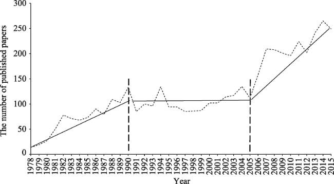
Figure 1 The number of papers published in Chinese journals about geomorphology over the past 40 years

1.2 The changing content of published papers

Academic achievements provide an important indicator of the development stage of a discipline, in addition to being a measure of its practical applicability. Geomorphology is a foundation for the development of land and national defense infrastructure, and has consequently made important contributions toward meeting China’s construction requirements over the past four decades.
Figure 2 shows the discipline system, research content and innovation model on geomorphology in China. Systematic geomorphology, branch geomorphology and applied geomorphology constitute the subject system of geomorphology. Moreover, other theory and new technology has been gradually introduced into geomorphology, which has gradually deepening and broadening the research fields of the geomorphology. Indicators of advances within this discipline are discussed below in detail.
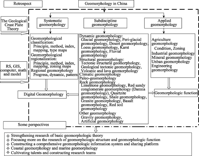
Figure 2 Retrospect on discipline system, research content and innovation model on geomorphology and some perspectives
1.2.1 Continual innovation in geomorphologic research theory and a significant elevation in its academic status
Over the past four decades, and especially from the onset of the 21st century, geomorphologic research in China has evidenced timely absorption of scientific research innovations, which have led to the advancement of theory, resulting in a significant elevation in this discipline’s academic status. Four decades ago, plate and geosyncline theory, derived from geodynamics, was the main interpretive theory applied within this research field to determine geomorphologic morphogenesis mechanisms and to explain the formation and succession of plains, plateaus, and mountains. However, identifying the causal mechanism that brings these phenomena into being has proved challenging (ECCPG, 1980).
A significant breakthrough was achieved at the end of the 20th century with the development of the geological crust plate theory. Plate theory was applied in geomorphologic studies to explore the differentiation of morphogenesis aimed at deepening understanding of the functions of internal agents within this process and developing a theoretical explanation of the deep tectonic characteristics of the earth and the linkage mechanism underlying plate tectonics. This development marked a revolution in the history of geomorphologic research that was of great significance (ESDSRG, 2002).
1.2.2 Ongoing expansion of the research field and its content derived from traditional geomorphology through comprehensive research encompassing geomorphology and physical geography, thereby deepening the breadth and depth of geomorphologic theory
A number of synthetic and cross-sectional research initiatives have contributed to the advancement of geomorphology. Such studies have examined geomorphology in relation to land use, vegetation cover, hydrology, and soil classification. The significant and ongoing expansion of research content and depth is reflected in several areas. These include: studies on changes in vegetation cover in different types of geomorphologic regions (Liu et al., 2011), the impact of terrain on precipitation (Qian and Li, 1992), debris flow prediction based on different ecological contexts (Zhang, 2004), the distribution characteristics of organic micro-pollutants in tidal flat sediments of the Yangtze River estuary (Liu et al., 2002), the relationship between rocky desertification and geomorphology, and lithology, precipitation, and population density in the southwest karst area (Zhang et al., 2013).
Geomorphologic research has been conducted not just on the earth’s surface; it has also been conducted on the moon, covering areas such as the morphology of its surface, the classification of lunar craters and their spatial distribution, and lunar evolution (Cheng et al., 2014). This research has even been extended to an examination of Mars to determine whether conditions for the formation of aeolian sand geomorphology are present on this planet (Li and Dong, 2016).
1.2.3 Evolution of the discipline into a full-fledged academic subject
Whether or not a disciple has evolved into a full-fledged system of knowledge is an important indicator of its maturity. Having been established as a research field for nearly half a century, geomorphology has demonstrated progress in a number of areas that indicate its evolution into an independent and mature discipline. These areas include mechanisms relating to surface morphogenesis, as well as geomorphologic classification, regionalization, application functions, and geomorphic research methods and techniques.
1) Maturity of geomorphologic classification system
There has been a long-standing dispute relating to the application of the principles of genetic and morphological classification within the discipline of geomorphology. In the 1950s, an outcome of key scientific research conducted within this field in China was published as Chinese Geomorphologic Regionalization (RZCCAS, 1959). Studies within this publication conducted by the Natural Zoning Work Committee of the Chinese Academy of Sciences posited the view that the genesis principle should be applied for classification and emphatically stated that the principle of morphological classification should not be used.
Based on the geological structure and new tectonic movement of China’s mountainous areas, the following categories of mountains were identified: extremely high mountains, high mountains, middle mountains, low mountains, and hills and other landform types. Within smaller geomorphic units, the following land types were categorized: alluvial plains, lake plains, karst Fenglin and other land types. The division principle applied for this system of land types entailed flaws such as the lack of connection between the form and the causes and a significant lack of coordination between high-level types divided by geological structure and low-level types divided by external surface agents.
A further issue concerned the indicators used for categorization. Whereas mountains were categorized according to differences in elevation, this criterion was not used for plain regions, resulting in an imbalance of indicators. Moreover, the geomorphologic classification system was still at an exploratory and therefore evolving stage at the time. Chinese geomorphologists applied both the morphologic and genetic principles of division in their research (Zhou et al., 1956; RZCCAS, 1959; Shen, 1980). The article by Li et al. (2013) entitled “Research on geomorphologic regionalization of China” that was published is the most representative study that applied morphologic division. Using land surface morphological features, these authors categorized the land surface into seven types: plains, platforms, hills, low relief mountains, medium relief mountains, high relief mountains, and extremely high relief mountains. They then subdivided the 28 basic geomorphologic types into five levels based on the indicator of elevation. This classification system entailed the advantages associated with the innovative introduction of the indicator of relief for mountain categorization to the traditionally inherited geomorphic features.
However, it also evidenced defects relating to principles and indicators as follows. First, the influence and effect of genetic factors on morphology were not taken into account. The second issue related to the introduction of five elevation types, namely, low elevation (< 1000 m), medium elevation (1000-2000 m), high-medium elevation (2000-4000 m), high elevation (4000-6000 m) and extremely high elevation (≥6000 m) as a classificatory indicator. The addition of these five elevation types to each of the morphologic types (plains, terraces, hills, low mountains, medium mountains, and high mountains) created a complication.
In recent years, geomorphologic division applying the unity principle of morphology and genesis has gained acceptance within the academic community, and has significantly advanced geomorphologic theory and enhanced its application. Topographic and geomorphologic characteristics feature as basic research objects within several projects under China’s 13th Five-Year Plan (2016-2020). These projects include a survey of China’s geographical conditions, an investigation and assessment of torrential disasters in China, the study of urban mountain torrents in China and a trans-provincial investigation of the physical geographical entities relating to China’s terrestrial terrain. These projects all apply the unity principle of morphology and genesis to determine geomorphologic types and to develop geomorphologic regionalization, which reflects significant progress within geomorphologic research.
2) Refinement of geomorphologic regionalization and the ongoing emergence of sub-disciplines
China’s geomorphologic types are complex and diverse, exhibiting varying regional distribution patterns. Consequently, the national geomorphologic regionalization program is very different. After years of effort, the results of regionalization have gradually begun to follow the same direction. The draft document on geomorphologic regionalization developed in the 1950s was the first attempt to initiate regionalization covering all types of land areas in China (RZCCAS, 1959). Accordingly, the genesis principle was applied to divide the country’s land area into 18 primary areas (large regions), 44 secondary areas (regions), and 114 tertiary zones (geomorphologic provinces). The fourth level division into districts was not completed. Complete and accurate data were compiled for the regionalization initiative, which resulted in the first broad-based monograph that synthesized the knowledge of China’s geomorphologic researchers. Matched with a national geomorphologic map at a scale of 1:4,000,000, the data presented in the monograph demonstrated area attributes and relatively accurate boundary lines.
Because of the weak research foundation and the brevity of the research period, this monograph evidenced some flaws. First, regionalization units were constructed according to the tectonic genesis principle, which does not fully reflect the law of geomorphologic formation, occurrence and development in China. Second, despite that the geotectonic principle was mentioned in the description, first-level regional division did not consider China’s three-level terrain pattern, which can not answer what constraints and impacts of tectonic system on China’s geomorphology were, and why the redundant situation of the first-level regions that up to 18 units appeared. Third, division indicators were not specific. They generally proposed tectonic, surface morphology, and external force, but lacked specific indicators and grading of indicators. Fourth, the regionalization system was incomplete, with many third-level regionalization units remaining vacant.
This initial regionalization effort was followed by several others. One of the most representative initiatives in regionalization, entitled “Research on geomorphologic regionalization of China”, was developed based on morphology (Li et al., 2013a). This initiative demonstrated several improvements. Using a regional combination transformation principle for geomorphologic types, it developed innovative practical research leading to geomorphologic regionalization within China. Second, it considered obvious differences between three geomorphologic ladders relating to China’s land mass, which helps divide China’s main land into 6 large geomorphologic regions at the first level. Subsequently 37 regions were categorized at the second level with attached maps and area values according to a combination of geomorphologic types.
In recent years, an in depth engagement with geomorphologic regionalization theory has been evident within discussions on improving and refining the discipline’s practical applications. There are many projects that include geomorphologic regionalization tasks within China’s 12th and 13th Five-Year Plans (2011-2020). The implementation of a combination of morphological, genesis, and service-related approaches within projects requires the adoption of a broad perspective within geomorphology. Such projects include ecological regionalization and planning, ecological evaluation and construction, geomorphologic disaster prediction and prevention, traffic line location selection, and culvert foundation stability, urban and rural flood geomorphologic analyses of urban and rural flooding, and geomorphologic functional regionalization in nature reserve areas.
Based on the needs of the special collaborative national project of the Geographic Conditions Census involving several academic institutions, the Institute of Geographic Sciences and Natural Resources Research of the Chinese Academy of Sciences created five levels of geomorphologic division at a scale of 1:250,000. This project will provide the most detailed regional categorization of China’s geomorphology. The latest advances in China’s geomorphologic regionalization strictly define the geomorphologic grading and index systems, grading characteristics, and applications of new technology, revealing continual improvements in the country’s geomorphologic regionalization and the evolution of regionalization within branch disciplines. These advances are evident in, for example, the regionalization of China’s ecological geography (Zheng, 2008), and specifically that pertaining to the comprehensive natural regionalization of the Gobi Desert (Shen and Wang, 2013; Shen et al., 2016).
1.2.4 Continued expansion of research teams with the capacity to conduct scientific research on a large scale
The earliest geomorphologic studies by Chinese scholars appear to be “Shandong coastal topography,” conducted by Huang between 1934 and 1935 under the guidance of Weng and Ding (EGCHB, 1993), and a follow-up study by Li (1939) on “Chinese Geology” divided the country into 19 regions (GSC, 2006). Geomorphologic research began to enter the research tracking system after the establishment of a geomorphologic research laboratory by the Institute of Geography of the Chinese Academy of Sciences in 1954. Subsequently, a geomorphology major was offered by the Department of Geology and Geography at Peking University in 1956 and by the geography departments at Nanjing and Northwest Universities, and at East China Normal University, in 1958. Consequently the number of professionals trained in geomorphology began to rise substantially. Geomorphologic research laboratories were also developed by the Guangzhou Institute of Geography, the Changchun Institute of Geography, and the North China Institute of Geography of the Chinese Academy of Sciences, which conducted studies of geomorphologic issues on a large scale within China.
According to the statistics, there are dozens of geographical research institutes where geomorphologic professionals are engaged in research and teaching. There are close to 100 universities or colleges offering geography as a major, and more than 100 companies associated with geography, constituting a basic system of enterprises and production sections within the country (GSC, 2006).
Recent advances in research show that geomorphology in China has evolved into a complete disciplinary system, with a relative alignment of professional teams, an accelerated pace in the training of young talented researchers, and wider promotion of research and development reservation ability, fostering capacities to conduct big scientific research projects (Cheng et al., 2016a). For example, a recently completed research project on “Southwest Karst Mountain Rocky Desertification and Adaptation Ecosystem Regulation” addressed significant research problems through a comprehensive geomorphologic study. This project covered spatial and temporal patterns, changes and their driving forces, biogeochemical processes and rates of soil formation, dynamic processes relating to the water cycle and hydrological effects, and plant communities and their ecological adaptability to rocky desertification in China’s southwest karst area. Incorporating a range of scientific and practical approaches, the project engaged systematically and comprehensively with scientific problems such as mechanisms, processes, the rate and ecological construction, disaster prevention, and control of rocky desertification in appropriate ways.
The countermeasures that were developed will provide important guidelines in the rehabilitation of the ecological environment in China’s southwestern region. Another example of a recent project is the newly launched “China Mountain Torrent Disaster Investigation and Evaluation” Project, which is an important indicator of Chinese geomorphologic research on disaster prevention.
1.2.5 Advances in research methods and the establishment of a research system entailing new technologies
In recent years, with the rapid development of geographic information systems, remote sensing, global positioning, and other technologies, a new research methodology entailing extraction on geomorphologic characteristics has been launched using aerial photographs, satellite imagery, a digital elevation model (DEM), and other data sources. Moreover, there has been significant progress in areas such as determining the boundaries of geomorphologic types and in the acquisition and presentation of information on gradual geomorphologic changes (Chen and Zhao, 1990; Zhou et al., 2009a).
In particular, the development of a DEM at a scale of 1:50,000 by the national surveying and mapping departments, as well as the high-level accuracy of DEM data for the region between 60ºN and 56ºS obtained from the US Shuttle Radar Topography Mission (SRTM, http://srtm.csi.cgiar.org/) in 2000, and from ASTER GDEM data, have been notable. These developments have not only greatly facilitated the accurate extraction of geomorphologic feature data, but have also provided a sound basis for obtaining DEM data to extract typical geomorphologic features demonstrating a high-level accuracy on a large scale. In recent years, Interferometric Synthetic Aperture Radar (InSAR), Light Detection and Ranging (LiDAR), and other advanced technologies have been widely applied in the area of geological disasters. Examples of these applications include large-scale topographic surveying, fault movement monitoring, earthquake area deformation, uplift before volcanic eruptions, and deformation before landslides (Shan et al., 2001).
There are numerous examples of research entailing the extraction of quantitative digital geomorphologic data using DEM and remote sensing images. Geomorphologic feature segmentation, diluvial fan feature extraction, and geomorphologic mapping were conducted based on high resolution remote sensing images and highly accurate DEM data (Miliaresis and Argialas, 2000; Jordan et al., 2005). An overall review of DEM data modelling, uncertainty, methods of analysis, scaling effects, and high performance computing methods were addressed, moreover, the application of this methodology in digital terrain analysis (DTA), extending DTA research concepts and methods to other field models in the geosciences were discussed (Tang, 2014).
Evidently, geomorphologic remote sensing mapping has advanced as a result of the replacement of the traditional manual method of data compilation and mechanical mapping by remote sensing and GIS technology. A new technological system of remote sensing mapping has thus emerged. The Geomorphologic Atlas of People’s Republic of China (1:1,000,000) is an important example of a comprehensive analysis of geomorphologic types using multi-source data such as remote sensing images (Zhou et al., 2009a). This project began in 2004, with 15 existing geomorphologic maps at its disposal. These maps, including those developed for Beijing, Xi’an, and Taiyuan, created at a scale of 1:1,000,000, with a legend system and the “Mapping Criterion for Chinese 1:1,000,000 Geomorphologic Maps”, were compiled and published (IG, CAS, 1987).
The Institute of Geographic Sciences and Natural Resources Research of the Chinese Academy of Sciences collaborated with other relevant national universities developed an interpretation of geomorphologic types based on remote sensing for 74 maps using standard sheets at a scale of 1:1,000,000, and designed China’s first million scale digital geomorphologic classification database system based on a layered and hierarchical merging and expansion of the previous classification system to a scale of one million (ECGAPRC, 2009; Zhou et al., 2009b; Zhou et al., 2010). A layered and hierarchical combination classification method was adopted, combining morphology and genesis and incorporating morphology-structure data organization mode of point, lines and polygons, data support of geologic maps, old geomorphologic maps, and DEM at multi-scales. Moreover, a methodology to synthesize the interpretation to digital geomorphology based on data derived from multiple sources such as remote sensing images was applied using an appropriate technology. Thus, the compilation and publication of the Geomorphologic Atlas of People’s Republic of China (1:1,000,000) and the “Remote Sensing Interpretation and Mapping for Digital Geomorphology” filled a knowledge gap, both domestically and internationally, in this field. The “Research and its Application of Digital Geomorphologic Maps for China (1:1,000,000)” Project was awarded a second prize for National Science and Technology Progress in 2009.

2 A retrospective and future projected analysis of the status of research within geomorphologic sub-disciplines

Given sustained in depth research and the requirement to expand application in the field of Chinese geomorphology, its sub-disciplines, primarily comprising dynamic geomorphology, climate geomorphology, structure geomorphology, and applied geomorphology have developed at a fast pace. Moreover, learning exchanges have occurred between geomorphology and related disciplines regarding their respective research methods. Geomorphologic sub-disciplines have evolved through the introduction of relevant principles and methods from other disciplines. Examples include river power, coastal hydrodynamics, glacial dynamics, and wind power. The specific research fields of paleoclimate and tectonic geomorphology were extended as a result of developments that occurred within other disciplines such as paleogeography and palaeoclimatology relating to sedimentary facies, sea surface changes, and neotectonic movement. Consequently, new research fields have evolved within all of these geomorphologic sub-disciplines. In addition, the development of rock geomorphology (e.g., studies on Danxia and granite) has made significant progress (You and Yang, 2013).

2.1 Dynamic geomorphologic research

Dynamic geomorphology, which focuses on the operations of external agents and the formation of geomorphologic features, encompasses glacial geomorphology, periglacial and permafrost geomorphology, aeolian geomorphology, loess geomorphology, karst geomorphology, fluvial geomorphology, and coastal and submarine geomorphology.
2.1.1 Glacial geomorphologic research
China’s glacial geomorphology has mainly focused on the alpine region of the Tibetan Plateau and the high altitude belts of the Tianshan and Altai Mountains. The study of glaciers was almost non-existent prior to 1949. From the 1950s, beginning with investigations of the Yulong and Gongga mountains, the areas covered by glacial research were gradually extended to encompass the entire Tibetan Plateau and the Tianshan and Altai Mountains. The difference between glaciers in China and those at the north and south poles is mainly related to the glacial short history and the stage of glacier development (Zheng, 2000; Zhou et al., 2001; Cui et al., 2011). Chinese scholars in the field of glacial geomorphology have focused on the space, genesis, and stage of China’s glacial development. A complete inventory of glaciers is currently being maintained in China, where glacial science has also attracted academic attention (Zhou et al., 2003; Yang et al., 2006; Zhao et al., 2011a; Liu et al., 2011). In recent years, glacial geomorphologic research has gradually been extended to cover the Tianshan Mountains and the Western Qinling and Pamir Mountains (Wang et al., 2011; Zhao et al., 2011b; Zhao et al., 2013). Several scholars have also addressed the long-standing question of whether any traces of the Quaternary glacier remain in eastern China’s mountainous areas (such as Mount Lushan and the Siming Mountain in east Zhejiang). These scholars have confirmed that the associated morphology of the so-called “Quaternary glacial relics” is not in fact glacial ruins, but were mainly formed as a result of weathering, gravity, and fluvial processes (Xie and Cui, 1983; Sang et al., 2011).
2.1.2 Periglacial (permafrost) geomorphologic research
The distribution of periglacial (permafrost) geomorphology is extensive in areas characterized by a severely cold climate. Despite this geomorphology bears a certain relationship to glacial processes, it is also extensive in regions with no glacial process but frost action, whose ground surface is subject to a process of alternate freezing and thawing. Though Chinese researchers in the field of geomorphology have long been engaged in the study of periglacial geomorphology, preliminary research has mostly focused on information extraction on the characteristics and distribution of periglacial geomorphology (Xia, 1960; Zhu and Cui, 1992; Zhao et al., 2007), but rarely or no research focuses on vegetation, soil, hydrology, and micro-geomorphology in periglacial geomorphologic regions. In recent years, periglacial geomorphologic studies have focused on the Tibetan Plateau, the Qinling, Wutai, and Lesser Khingan Mountains, and the Liaodong mountainous region (Lv et al., 2010; Liu et al., 2014; Wu et al., 2015; Zhang et al., 2016; Zhu et al., 2016). These studies have shown that periglacial geomorphology can be further subdivided into various morphological types such as stone rivers, rock slopes, fields with boulders, stone forts, nivation hollows, shitangs, and jump stone ponds.
All of the abovementioned types can potentially exhibit mobility as a result of surface runoff action. The conditions for the growth of cold-tolerant plants are present in regions evidencing periglacial geomorphology, with community distribution demonstrating characteristics of differentiation. More shrubs can be found on glacial rock slopes than in fields of boulders, whereas the reverse is the case for herb species. Plant species extending from the upper part of the periglacial geomorphology to the lower part show a tendency toward transition from simple to complex communities. Moreover, soil development is also evident in periglacial geomorphologic regions, with soil formation and soil organic matter showing a tendency to increase moving from uphill to downhill areas. A further examination of these types reveals that the slopes of jump stone ponds are steeper, resulting in low stability. Consequently, stones are prone to tumble down, causing disasters. Projecting into the future, the integration of periglacial geomorphology and botany, soil science, hydrology, and other related disciplines within a comprehensive periglacial geomorphologic research system has emerged as an important future research direction for this sub-discipline.
2.1.3 Aeolian geomorphologic research
Aeolian geomorphology is formed by the effects of wind and is prevalent in arid, semi-arid, and even semi-humid areas of northwestern China. Thus, wind effects have influenced the formations, shapes, spatial combinations, and evolution of these areas (Greeley and Versen, 1985; Lancaster, 1994; Zhang and Dong, 2014). In the 1950s, the Chinese Academy of Sciences organized a comprehensive team of researchers to investigate desert areas. Subsequently, in the 1960s, the Chinese Academy of Sciences set up the Desert Research Institute. From this time onward, the depth of research as well as research institutions engaged in this field have demonstrated continuous expansion. Currently, a well-developed system is in place, covering all of the relevant research fields. In the 1950s and 1960s, the focus was mainly on desert exploration and classification, and summarizing the results of numerous experiences of sand control. From the 1960s to the 1990s, the focus shifted to sand movement law and the development dynamics and scientific control aspects of desertification.
From the 1990s, the concept of sustainable development has increasingly been integrated into desert research. Experimental stations have been widely established within every sandy stretch of desert from where in depth studies are conducted in areas such as regional climates and desert genesis and development, plants and ecological communities in sandy areas, water-saving agriculture in sandy areas, system construction of ecological shelter forests in sandy areas, characteristic resources and the sand industry, and ecological resources and desert GIS construction in sandy areas (Zhu and Zhu, 1999; Lu, 2000; Zhu and Shen, 2004). Consequently, China’s desert-related research is cutting edge at the global scale. Aeolian geomorphologic research that is specific in its content and coverage of areas is also expanding, resulting in notable achievements. Examples include studies conducted on the wind system of feathery dunes in Kumtag Desert, sandy mountain formation, sandy micro-geomorphology, the hydrological dynamics of dune lakes in the Badain Jaran Desert, and wind energy research in the Gurbantunggut Desert (Yang, 2000; Guo et al., 2011; Shao et al., 2013; Cui et al., 2014). The development and publication of geomorphologic maps of deserts such as Tengger reveal specific spatial distribution patterns and patterns of change of China’s desert geomorphology (Wen et al., 2014).
2.1.4 Loess geomorphologic research
China has a long history of research on loess geomorphology (mainly relating to the Loess Plateau). The definition of loess areas and the trajectory of scientific achievements in this area began in the 1950s with the institution of a comprehensive team for soil and water conservation established by the Chinese Academy of Sciences in the middle reaches of the Yellow River. The “Comprehensive management and development in the Loess Plateau” Project was subsequently initiated in the 1980s, followed by the development of a number of experimental bases for ecological construction (Liu and Zhang, 1962; SSTLPCAS, 1991). The study of loess geomorphology entails a detailed description of loess geomorphology and includes research topics such as the genesis of loess and loess and soil erosion.
Studies have shown that the formation of the Loess Plateau can be mainly attributed to sustained winds (Liu et al., 1985). At the end of the New Tertiary era (2.4 million years ago), China’s monsoon climate began to develop, and the northwest began to experience drought and dry wind effects, with a gradual strengthening of winds emanating from a northwestern direction. Because of the Qinling Mountain barrier to the south, dust began to accumulate in the area. Extending back to the early Quaternary and middle Pleistocene eras (1.1 to 0.6 million years ago), dust accumulation reached a substantial level, with the average stacking thickness reaching 100-200 m. This led to the formation of the Loess Plateau (Xiong et al., 2014). Subsequently, there was a gradual increase in hydraulic erosion, with this erosion exceeding the dust accumulation, leading to the formation of loess gully landforms (Jing et al., 1997).
Studies of loess and soil erosion have shown that the area of soil erosion currently extends to 45.4 million km2 in the Yellow River Basin, with an average annual erosion rate of 1.6 billion t/a, and 976 million t/a of natural erosion (Jing et al., 1993). Commencing from the 1990s, there have been significant advances in ecological construction, leading to a decrease in soil erosion, which has stabilized at 1.1-1.2 billion t/a (Zhang et al., 1994; Wang et al., 1992). The onset of the 21st century has witnessed a significant reduction in soil erosion as a result of the implementation of ecological construction measures such as conversion of farmland to forest and grassland. Thus, the annual level of sediment transportation has more or less been maintained at 6-7 billion t/a in the Yellow River, with the total amount of erosion being roughly 1 billion t/a in this area. Years of effort aimed at halting soil erosion have entailed experimenting with runoff control and gentle slope land and terraces that have resulted in a significant reduction of soil and water loss in China’s loess geomorphologic areas (Shen and Hong, 2003; Guo and Duan, 2004; Shen et al., 2004).
Over the past decade, research on loess topography has advanced and been refined. For example, the use of fractal parameters to calculate the fractal dimension and stability coefficient of river networks has been found to be a feasible method for studying quantitative geomorphologic features (Cai et al., 2014). DEM data have been applied in studies to explore the spatial variability of vegetation cover, land use, and landslide frequency across different morphologic conditions (Yang and Bi, 2011; Yang et al., 2012a; Qiu et al., 2016). Experiments relating to geomorphologic extraction have also been conducted on the Loess Plateau (Zhang et al., 2012; Jiang et al., 2013; Xu et al., 2014; Zhao et al., 2016). A comparative study using the edge detection operator method has been conducted on the final generation of shoulder line of the valley (Yan et al., 2011). The regional growth method has been used to solve the problem of a large number of debris polygons in the partition of positive and negative terrains and to alleviate the slope distortion problem (Liu et al., 2016). Principal component analysis, based on multi-directional DEM terrain shading, slope, and other indicators, has been applied to eliminate multicollinearity and reduce dimension. Further the logistic regression model has proved effective in extracting positive and negative terrains on the Loess Plateau (Chen et al., 2012).
2.1.5 Karst geomorphologic research
Karst geomorphology is widely distributed in China, especially in the southwestern provinces. In the 1950s and 1960s, the study of karst geomorphology focused on the aspect of type (Zeng, 1994). In the 1970s and 1980s, further studies were conducted on the karst caves, pots, and developmental laws. From the 1990s onward, research gradually progressed to the areas of the karst water environment and regional ecological geomorphologic classification (Li et al., 1994; Yuan, 2015). In the last decade, in depth research on ecological restoration and construction and other issues relating to rocky desertification has been conducted, for example, to identify soil erosion characteristics and for the ecological restoration of small watersheds. Other areas covered by this research include SAR image registration and rocky desertification lithology, and land use relationships (Zhang et al., 2005; Zhang, 2013; Gao and Xiong, 2014; Wang et al., 2015; Yang et al., 2015). To further explore the correlation between the erosion modulus and erosion factors in karst areas, a study applying a regression model used for multi-factor equation selection of the soil erosion modulus under different slope conditions was carried out. This resulted in an improvement of the prediction accuracy of the erosion sediment yield of gentle and steep slopes (Gao et al., 2013b; Li et al., 2015a; Peng et al., 2016).
2.1.6 Fluvial geomorphologic research
Though China has a long research tradition relating to fluvial geomorphology, systematic studies within this field only commenced in the 1950s. During the 1950s and 1960s, studies were conducted on the valley geomorphology of several rivers, including the Yangtze, Yellow, Amur, Han, Xiang, Qin, and Brahmaputra rivers. As a result, data were obtained on river beds and types, and on the evolution law, and fluvial geomorphology was explored in more depth (Shen, 1980; Shen and Cai, 1985). Up to the 1970s, fluvial geomorphologic research extended to river source landform. A practical investigation was conducted to address an information gap relating to the sources of the Yangtze and Yellow rivers. This study definitively established that the Yangtze River originated in the Geladandong Snowberg, the main peak of the Tanggula Mountains, and that the Kariqu River was the source of the Yellow River. In the 1980s and 1990s, the study of fluvial geomorphology was broadened to include the evolution of river beds and a new classification scheme for river types and their formation was proposed (Qian, 1985).
At the beginning of the 21st century, this area of study was further broadened to cover the relationship between river bed structures and mechanisms of fluvial geomorphologic evolution, river systems, as well as river basin erosion and the mechanisms of sedimentation and river balance (Wang et al., 2013; Xu, 2015). To accumulate the necessary information for exploring the evolution of estuaries, a study of estuarine hydrological dynamics and sediment accumulation was also carried out in the estuary of the Yangtze River (Wang et al., 2011; Guo et al., 2013b). In commemoration of the 100th anniversary of Shen Yuchang’s birth, the pioneer and founder of modern Chinese fluvial geomorphology, a review of the progress of research in this field was produced (Xu et al., 2016), which covered in this review included the development of water systems and the evolution of valley geomorphology, processes of erosion and sediment accumulation, as well as processes relating to river beds and river types, and research on fluvial geomorphologic systems. These studies represented cutting-edge developments in the study of fluvial geomorphology in China.
2.1.7 Coastal and submarine geomorphologic research
Coastal geomorphology research was carried out earlier in China than elsewhere in the world. In the 1950s and 1960s, a comprehensive coastline survey covering the entire length of China’s coastline was carried out. Submarine geomorphology types and their genesis within important water bodies, namely the Yellow and East China Seas, were also studied, as were the seabed sediments of the East China and South China Seas, thus providing a solid foundation for coastal geomorphologic research in China (Chen, 1985). In the context of global warming, China’s coastal geomorphologists predicted rises in sea levels for the period from the 1980s to 2030 based on trends of ground subsidence and sea level fluctuations in relation to the Yellow and Yangtze rivers and the Pearl River Delta, this was the first study to elucidate China’s coastal estuary dynamic (Ren, 1993). During the same period, studies were conducted on the pattern of delta sediment movement and the process of its formation, evolution, coastal tidal flat types, and dynamic changes, which provided a scientific basis for activities such as port construction, estuary management, and channel improvement (CLQGSC, 1989).
In the 21st century, the relationship between the coast and the oceans has emerged as an issue of growing concern, and coastal geomorphologic research has consequently advanced considerably in China. This research has been comprehensive in its coverage, addressing areas such as coastal types, genesis and evolution, specific studies on the Bohai, Yellow, and East China Seas, and the continental shelf of South China Sea, as well as reef distribution and scale of island, hydrology and shallow sea tides, marine life and ecosystems, marine meteorology and climate, the coastline division, and coast and harbor construction. The breadth and depth of this research and the application of new methods and technologies is set to enter a rapid and comprehensive phase of development (Shen, 1980; Zhang and Wang, 2006; Wang and Ji, 2011; Li et al., 2013b). The latest seabed geomorphologic research and the course of its development were summarized in China (Zheng et al., 2012). Moreover, they projected the future direction of research on China’s offshore geomorphology based on their analysis of the status of research on seabed geomorphology in China and abroad. With the continuous refinement of measurement technologies, China’s submarine geomorphologic research will shift from a macro focus to a micro focus, from large geomorphology to specific geomorphologies, and from morphological characteristics to geomorphologic processes. Moreover, this research will also further examine the effects of human activities on geomorphologic processes (Zheng et al., 2012).

2.2 Structural geomorphologic research

Structural geomorphology, which focuses on internal regulating structural forces that are dynamic, refers to a geomorphologic form entailing certain structural characteristics shaped through the interaction of internal and external geological dynamic forces. Structural geomorphologic research encompasses the relationship between geomorphology and structure, the occurrence of structural geomorphology and the process of its development, and the internal dynamic process of the earth’s structure, revealed by structural geomorphologic processes. In recent decades, research has advanced considerably in a number of related fields such as tectonic structural geomorphology, geological tectonic geomorphology, and volcanic and lava geomorphology.
2.2.1 Tectonic structural geomorphologic research
By the end of the 20th century, the geological plate theory had gained wide acceptance among geomorphologists, who hypothesized that the geosphere had a structure comprising three main layers: a core, mantle, and crust, with a warm current flowing through the mantle layer and producing a thermal convection cycle (ESDSRG, 2002). According to the theory of plate tectonics, continental plates of varying sizes are found in the rigid lithosphere of the earth’s outer crust, and the contact zones between the plates are affected by the convection of the warm current within the upper mantle that can result in movements of the landmass. The rocky component of the landmass in the contact zone may fold inward through a strike effect to form a mountain. Where the ground surface is plain or comprises a plateau, the plate block is relatively stable. Relative movements of the plates can lead to their collisions with each other, or to rifts, thereby forming the earth’s basic surface. In areas where plates become cracked, rifts or oceans are often formed; in areas where plates collide and extrude, trenches, islands arcs, sea rocks, and huge mountains are often formed. The formation and distribution of the earth’s landmasses and oceans, the geomorphologic patterns the high mountains, and of plains and plateaus on the land, are all outcomes of movements of the crustal plates (Cui et al., 2001; ESDSRG, 2002).
Many Chinese scholars have done extensive research in the area of tectonic structural geomorphology to elucidate the spatial patterns of the four geomorphologic steps in China, which is located in the eastern part of the Eurasian plate (Zhou et al., 1956; RZCCAS, 1959; ECCPG, 1980). The southeastern part of China is adjacent to the Pacific plate, and southwestern part connects with the Indian plate. The evolution and relative movements of these three plates have led to the formation as well as the restriction of the distributional characteristics of China’s geomorphology, commencing in the Mesozoic era, which also profoundly affected its formation, evolution, distribution, and regional combinations. The most representative outcome of tectonic structural geomorphic mapping is the “Geomorphologic Map for Land and Ocean of Asian and Adjacent Regions (1:8,000,000)”. The mapped area covers about 35% of the earth’s land surface and ocean geomorphology. The contemporary elements of the plate’s geomorphologic structure are represented in a thematic map using a smaller scale, which is a reflection of the advancement of tectonic structural geomorphology mapping in recent years (Chen, 2011).
2.2.2 Geological tectonic geomorphologic research in the field of geology
In recent decades, scholars in the field of geology have produced a number of significant findings based on their tectonic geomorphologic research conducted in national tectonically active regions. Taking typical regions as examples, they have studied the relationship between stratified geomorphologic patterns and plateau uplift in the Qinghai-Tibet Plateau and surrounding regions (Pan et al., 2004), as well as the geomorphologic features and oxidation history in the surrounding graben regions of Ordos. These researchers have analyzed the mode, rate, historical changes, stress fields, and dynamic mechanisms of neotectonic activities and their regulatory influence on the formation and evolution of various geomorphologic types (Mo et al., 2016).
The key methods used in geological tectonic geomorphology are the pattern analysis method, morphological analysis, correlative sedimentation analysis, and age analysis (Wang and Wang, 2005; Shi and Du, 2006). Based on the spatial distribution and deformation of plateaus, evidenced in river terraces and piedmont alluvial fans and gullies, the history and characteristics of regional tectonic activity can be determined (Pan et al., 2004; Ma et al., 2016). In recent years, with continuous improvements in GIS and RS technologies, multi-source SRTM-DEM and ASTER-DEM data have been extensively applied in structural geomorphology. Based on drainage, topographic indexes such as terrain fluctuation, area-elevation integral, channel slope, fractal dimension, the basin shape index, basin asymmetry, and the ratio between valley width and height can be computed. These can be used to comprehensively analyze the relative stability of the regional geological structure (Gao et al., 2013a). Thus, structural geomorphology is expected to play an important role in the study of circle action, which also develops toward the information and quantified directions.
2.2.3 Volcanic and lava geomorphology research
China’s volcanic and lava geomorphology distribution varies regionally according to geological structures, within two broad regions. The first region comprises land areas toward China’s eastern border, in which hundreds of volcanic groups and cones are present, forming part of the Pacific Rim volcanic chain. The second region comprises the volcanic groups of the Qinghai-Tibet Plateau and surrounding areas. Liu (1999) conducted a systematic study of the distribution of China’s volcanic geomorphology, including the history and geological characteristics of volcanic activity in China (Liu, 1999). In recent years, GIS technology has been applied to the studies of volcanic and lava geomorphology, thereby providing a supportive method for developing a detailed quantitative description of volcanic geomorphology.

2.3 Climate geomorphologic research

All geomorphologic types are continuously regulated and constrained by climatic conditions. Therefore, climatic geomorphology mainly focuses on the study of the combined characteristics of internal and external forces under different climatic conditions and the geomorphology formed as a result of this combination. The zoning and zonality of climatic geomorphology have always been key research topics within this discipline. For example, research combining mountain glacial geomorphology and climate change in relation to the Qinghai-Tibet Plateau and the alpine glacier that surrounds it has demonstrated the formation of glacial geomorphology and regional differentiation entailed in its development. The western mountain glacier of the Qinghai-Tibet Plateau formed early and glacial geomorphology was completely developed. However, the scale of the glaciers has gradually been reduced with rising temperatures commencing from the Oligocene era. The duration of the formation of the eastern mountain glacier has been shorter and at a smaller scale, and is confined to the local ridge which developed during the last Ice Age. Studies have also shown that not only has the regional climate affected glacial development; structural factors have also played a critical role (Shi et al., 1990; Shi et al., 1995; Shi et al., 1999; Zhang et al., 2013). In addition, studies have been conducted in associated fields such as frozen geomorphology and arid geomorphology.

2.4 Paleogeomorphologic research

In recent years, China has demonstrated significant research progress in several areas within the field of paleogeomorphology. The first area is geomorphologic evolution. Dynamic factors leading to geomorphologic changes have been identified, and studies have been conducted simulating the inversion of paleogeomorphology through geomorphologic evolution (Meng et al., 2012; Yang et al., 2012b; Lv et al., 2014; Lin et al., 2015). The second area in which significant progress is evident is the paleogeographic environment. For example, a study on paleogeographic restoration was conducted on the stratigraphic section for the Guangyi Building Project in Guang’anmen in Beijing. The findings of the study suggested that there was a significant correlation between morphological change that occurred 20,000 years ago with vegetative change and that evolution of the environment resulted in cooler and more arid grassland vegetation during the late Pleistocene epoch and warmer grassland and cooler meadow vegetation in this area during the Holocene epoch (Yue et al., 2011). This research relating to paleomorphology and the paleoenvironment has important implications for the future.
Another example is the study of lacustrine geomorphology and sedimentary characteristics in the Fenwei graben series that confirms the existence of lakes and the occurrence of rapid subsidence and river cutting events on a large scale during the middle and late Quaternary periods. This phenomenon occurred in the Weihe Basin and extended to the Linfen-Taiyuan Basin, even reaching the Datong-Yangyuan Basin, but there were no differences in the times when these events occurred in the different basins (Hu et al., 2012). The findings of paleogeomorphologic research have also been applied in exploratory oil reservoir research. The moulage and integrated geological methods, along with other methods have been applied to restore Jurassic paleomorphology in the Wangwazi and Longdong regions. The findings of an analysis of conditions under which reservoirs occurred indicated that the reservoirs were mainly distributed in a relatively high terrain near highlands, slopes, and ancient brae (Yuan et al., 2013; Pang et al., 2014; Wang et al., 2014). The study of comprehensive model for paleogeomorphology restoration has also been carried out gradually. A recently established comprehensive geological model is being used to further explore the restoration of integrated features of paleotopography and paleogeomorphology, as well as paleoclimatic change (Lu and Guo, 2013).

2.5 Research on rock geomorphology

Studies in rock geomorphology mainly focus on the evolution and geomorphologic features of the same rock types under different natural and geographical conditions, or on all kinds of rocks under the same natural and geographical conditions. The evolution and morphological characteristics of the same rock types vary significantly under different natural and geographical conditions. For example, granite in southern China mostly presents towering shapes like mountains, whereas it appears as low hills in northern and northeastern China, and in other places. This is because different lithofacies and lithologies produce different weathering characteristics of granite in varying natural conditions entailing physical weathering in some conditions and chemical weathering in others. Common geomorphologic rock types in China are: limestone, red sandy conglomerate (Danxia), quartzite, shale, granite, basalt, loess, and red soil. Karst and loess geomorphologies have been discussed in a previous section of this paper on dynamic geomorphology. Here, the analysis of research progress will therefore focus on the geomorphologies of Danxia, granite, and rhyolite rock.
2.5.1 Geomorphologic research on Danxia
In 2010, “China Danxia” was successfully nominated as a UNESCO world natural heritage. Given that the name Danxia has achieved worldwide recognition as a geomorphologic type, research on Danxia geomorphology conducted by Chinese scholars has correspondingly increased. In recent years, the scope and depth of basic survey data on Danxia geomorphology, supported by China’s Ministry of Science and Technology, has been continuously strengthened, which has led to the successive discovery of Danxia geomorphology in Tibet and other regions. Consequently, basic data gaps relating to Danxia geomorphology in some provinces have been filled, promoting studies on topics such as Danxia geomorphology distribution, classification, zoning and natural landscapes, and dependence on cultural landscapes (Peng, 2000; Guo et al., 2013a; Huang et al., 2015). Applying a formula from Huang Jin for quantifying Danxia geomorphology, background, development, and landscape characteristics in the Kongtong Mountains were analyzed (Li et al., 2013c; Zhao et al., 2014; Qi et al., 2015; Zhang et al., 2015).
2.5.2 Geomorphologic research on granite and rhyolite
Many unique geomorphologic granite types formed under southern China’s subtropical monsoon climate conditions. Their formation occurred through a tectonic process entailing different degrees of uplifting and undercutting during the late stage of the planation surface. A deep granite weathering crust was consequently created during the Pliocene and Miocene epochs. Examples of this granite geomorphology include peak and stone forests and modeling and wind stones found in the Huangshan and Sanqingshan Mountains (Cui et al., 2007; Chen et al., 2009). Studies have shown that China’s granite geomorphology demonstrates the impacts of evident zonal laws within different climate zones, especially latitudinal zonality. Researchers have therefore posited that the age of granite geomorphology is closely related to the prevalence of the plane created during the Pliocene and Miocene epochs. The uplift amplitudes of different mountains can be calculated as follows: about 200 m of uplift occurred in coastal areas, gradually increasing as it moved in the direction of the hinterland, reaching approximately 1,600-2,000 m in the areas of the Nanling, Dabieshan, and Funiushan Mountains (Cui et al., 2007; Chen et al., 2009).
The most typical type of rhyolite geomorphology is mainly distributed in the area of the Yandang Mountains in the eastern part of Zhejiang Province. Studies have shown that the regional rhyolite landscape can be divided into two categories entailing six subclasses and 16 unit types. The first category is an erosion and collapse type and the second is a river valley water type. The development of valleys and rock peaks along a plane is controlled by the regional fault structure, extending mainly in three directions: northeast, northwest, and east-west. The distribution of summits, peaks, and waterfalls exhibits zonality, extending in a vertical direction, as determined by neotectonic movements and lithological differences (Hu et al., 2008). Such studies are of particularly importance in revealing regional geomorphologic evolution in eastern China.

2.6 Other kinds of geomorphologic research

1) Gravity geomorphology
This type of research focuses on issues related to collapse and landslides. In recent years, as a result of ecological and environmental changes in China, mountain gravity geomorphologic research has been attracting increasing attention. Examples of work in this area include mapped zones of landslide disasters and the degree of hazard of landslides. In recent years, mathematical models have been introduced within risk assessments of debris flow, which have enhanced the division method relating to debris flow risk, making it more rational and objective. Studies have evaluated the risk of landslides in regional and drainage basins using evaluation indexes of topography, stratigraphic lithology, atmospheric rainfall, and human factors, along with gray relational analysis, principal component analysis, and the fuzzy mean clustering method. These studies could provide a basis for developing comprehensive systems of governance in regional and drainage basins (Qiu et al., 2016; Cheng et al., 2016b).
2) Artificial geomorphology
Given the increasing capacity of humans to transform nature, anthropogenic activities have emerged as the third leading factor in the genesis of contemporary geomorphologic processes. Artificial geomorphology relates to geomorphologic bodies with human characteristics shaped by artificial effects and natural genesis in a natural geographical context. Li et al. (2015b), who proposed the concept of artificial geomorphology, classified artificial genesis and geomorphology. They analyzed artificial geomorphologic aspects such as transition, the influence mechanisms of evolution, representations through mapping, and environmental impacts, and projected future developmental directions of artificial geomorphology. The study of future artificial geomorphology requires the consolidation of the construction of the disciplinary system, material composition, and morphological characteristics. It also requires a process of spatial expansion, including deciphering its developmental law, regional differences, and the cumulative environmental effects of geomorphology, environmental management, international comparative analyses, and other relevant research (Li et al., 2015b).

3 Future prospects

During the last 40 years, geomorphologic research in China has made a significant contribution to the development of the discipline, as well as to social and economic development (Xu et al., 2009; Shi et al., 2010). However, China is a country with diverse landforms, and there are still many major geomorphologic issues that require further exploration, including geomorphologic formation and differentiation, ecological environmental construction, sustainable development and allocation of resources, disaster prevention and mitigation, and the construction of a geomorphologic system that safeguards sustainable social and economic development. The 21st century marks the onset of an age of significant human progress in the earth’s management. Geomorphology, which focuses on the study of ground morphology, should further explore the topics described below to achieve future breakthroughs (Figure 2).

3.1 Strengthening of basic geomorphologic research and realizing the prejudgment of topographical variation by simulating the formation, cause, and evolution pattern of geomorphology

Contemporary geomorphology entails extending the ancient landform, with successive forms representing the future landform pattern. The basic research will reveal and analyze the succession rule. Currently, there are still a number of important practical problems to be resolved, globally, requiring basic research and analysis. This entails an examination of the abovementioned problems relating to the formation and differentiation of geomorphology, morphological features and the geographical landscape, the geomorphic process and the geologic structure, the structural type and the regional combination, and the systematic development of the discipline of geomorphology. Important future directions in geomorphologic research include developing a geomorphologic recognition system, simulating the process of geomorphologic formation and succession, realizing the prejudgment of topographical variation, and developing a basis for decision making and improved management in relation to geomorphology by applying modern scientific thought and existing practical information in conjunction with advanced GIS technology.

3.2 Strengthening crossover studies between geomorphology and other disciplines of geography, to expand the scope of geomorphologic research and develop an integrated geomorphologic approach

Geomorphology constitutes the basic space of human activities on the earth’s surface, supporting surface fauna and flora, hydrology, soil, local climates, and land use. As long as there are morphologic changes, corresponding basic changes will also continue to occur in relation to the surface environment, resources, and human activities. Therefore, the essential direction of future geomorphologic research will be to implement multiple geomorphologic function-oriented studies, for example, on the relationship between landforms and environments, resources, disasters, human beings, tourism, and land utilization. Consequently, the scope of geomorphologic research will be extended and an integrated system of geomorphologic development will be established.

3.3 Implementation of in-depth studies on geomorphologic structures and functions, and enhancement of geomorphology’s application potential

Geomorphologic types, regional combinations, and the corresponding quantity constitution and spatial permutation and combination characteristics collectively constitute geomorphologic structure. There are numerous functional aspects of morphology that interact with human activities such as land use, ecosystems, local climates, land surface hydrology, soil, tourism, transportation, urban construction, port construction, and geological disasters such as floods that are restricted and influenced by geomorphologic structures. Because all functions are restricted by the structure, structural development has emerged as an important future direction for this discipline. This entails establishing various aspects of geomorphology relating to the ecology, resources, disasters, engineering, tourism, urban development, architecture, transportation, and management. Evidently, the establishment of a theoretical system of geomorphologic structures and functions is necessary to deepen geomorphologic research and improve its practical contributions to sustainable ecological, economic, and social development at a national scale, which is certain to become a vital future development trend in geomorphology.

3.4 Consolidation of an information system relating to resources, the environment, and geomorphology and establishing an information sharing platform on resources and the environment to facilitate industrial information upgrading relating to geomorphology

It is inevitable that a powerful country like China that prioritizes geomorphology would apply advanced methods and technology such as those related to holographic research to study geomorphologic systems. As a first step for conducting this type of research, it is necessary to establish technologies for obtaining holographic information on geomorphologic bodies, including the positions of geographic coordinates, the holographic characteristics of the terrain and coated objects, and the characteristics of land use by applying remote sensing technology and geographical methods. Second, the resource environment space and quantitative databases of the geomorphologic system need to be developed to provide a multi-scale geographic database that meets different functional requirements. Next, the use of a computer recognition and analysis system enables the automatic extraction of various types of geomorphologic data for the performance of target analysis so as to achieve all-round analysis, processing, and output functions. Last, the creation of an intelligent geomorphic system with pre-research requisition capacities and comprehensive improvement of automation research capacities leads to the enhancement of the landform intelligent information industry.

3.5 Strengthening coastal and marine geomorphologic research and acquiring holographic information on coastal and marine resources and their environment to transform China from being a large country with an extensive marine environment into a marine power

China’s marine environment comprises the Yellow, East China, and South China seas, as well as the continental Bohai Sea, the Beibu Gulf between China and Vietnam, and the country’s coastline that covers a distance of 18,000 km. The Taiwan and Qiongzhou Straits are further components of this environment. China can therefore be considered as a country that has an extensive marine environment, with vast maritime territories and a very long coastline. Consequently, basic state policies are required to enable it to establish itself as a marine power that maintains a balance between development of its marine environment and resource utilization.
There is promising potential in the 21st century for the achievement of a major breakthrough within marine science. Geomorphologists should consider advancing marine studies, which are currently lagging behind, as their mission and undertake the following actions. They should conduct studies on offshore geomorphic types and their sedimentation characteristics to develop the essential structure and sedimentation environment of China’s continental shelf. The resulting knowledge base would provide a scientific basis for protecting ocean rights and interests while enabling the development of ports. Site-specific stations should be constructed for observing geomorphology and the offshore environment. Such observations would focus on marine meteorology and hydrology, sea creatures, ocean pollution, and other relevant aspects to provide a basis for decision making relating to the protection and sustainable management of the marine environment and oceanic ecosystem.
A geomorphologic investigation and analysis of marine resources (including geomorphologic and geological environment of gas resources, types and quantities of hydrocarbon resources, gas layers, the types and distributions of mineral resources, the underwater sedimentation environment and the distribution of sedimentary mines, and differentiation and exploitation research related to ocean tidal power) should be conducted. There is also a need to conduct a preliminary assessment of geomorphologic resources and the deep sea and pelagic ocean environments. By the second half of the 21st century, marine holographic geomorphologic research should be in progress. This would cover marine geomorphology comprising mountains, plains, and trenches within the ocean and the oceanic tectonics of typical sea areas, the geomorphologic regional structure and the differentiation of ocean areas (ocean geomorphologic regionalization), and the geomorphology of oceanic environments, including the geomorphology of loop currents and differentiation of oceanic temperatures and sea creatures (animals, plants, microorganisms, and natural regionalization of the seas).
In addition, such research would cover the geomorphology of marine resources, including the geomorphologic characteristics and distribution of oil and gas fields, the types and distribution of oceanic minerals, as well as the differentiation and biomass of marine resources such as fishes, cetaceans, and shellfishes. The enormous energy potential of tidal currents is a vital resource for future utilization. This will be an important long-term research direction for marine geomorphology during the 21st century. It is conceivable that pilot tests on the energy produced by tidal currents will be conducted during this century.

3.6 Strengthening talent training and academic team building, establishing a sustainable system for developing talent training, and ensuring the gradual ascendance of geomorphologic research in China

Given that topography and geomorphology are fundamental land and carrier for the survival and development of a country, they require management by professionals deploying scientific thinking and methodologies. Based on China’s development requirements, the need for professional geomorphologists, and correlatively of talent teams, will continue to increase. Thus, talent training and training to develop the research and development capacities of professional teams will constitute an important future trend in geomorphology in China.
Focusing on the cultivation of high-quality professionals is a recommendation of this study. This requires, as a first step, perfecting the recruitment system of geography departments within universities and cultivating geoscience professionals who are adept at geomorphology. Moreover, relevant courses that examine the relationships between geomorphology and environmental factors and between geomorphology and resources and the social economy should be developed and expanded. Consequently, universities would become the foundation for cultivating the talents of budding geomorphologists and developing professionals with a comprehensive geomorphology background. The cultivation of middle level and advanced expertise in geomorphology within research institutions and universities is critical to develop a sufficient cadre of graduates and postgraduates. It is important to emphasize the cultivation of practical abilities and to strengthen capacities for application when training geomorphologists. As morphology and geomorphologic features relate to the earth’s surface, without investigation and practice in the field work, it would be impossible to acquire skills in classifying topographies and their formation mechanisms that would reveal the process and outcomes of the interactions between geomorphology and geographical factors. Thus, sustained and long-term professional training in the field of geomorphology should be pursued to develop and apply the practice of comprehensive geomorphology.

The authors have declared that no competing interests exist.

[1]
Cai Lingyan, Tang Guoan, Xiong Liyanget al., 2014. An analysis on fractal characteristics of typical landform patterns in northern Shaanxi Loess Plateau on DEM.Bulletin of Soil and Water Conservation, 34(3): 141-144. (in Chinese)Adapting the fractal analysis method and raster DEMs of 25m 25m,this paper probes into the spatial distribution of landform patterns in the loess landforms of Northern Shaanxi Province by calculating the fractal dimension and stability coefficient of stream-network.Experimental results show that:(1)The complexity of fractal structure differs with various types of loess landforms,embodied mainly in diverse fractal dimensions and stability coefficients.Among these,loess hill and ridge regions possess the highest fractal dimension and the lowest stability coefficient,reflecting its most complex geomorphological structure in the area;loess tableland and scattered loess tableland regions rank the second;and the transitional regions between loess and desert,with rather smooth and simple terrain,present the lowest fractal dimension and the highest stability coefficient.(2)It is proved that the fractal parameter based investigation on the geomorphic features of loess landforms is feasible,and DEM datasets can play a critical and fundamental role in the process.The outcomes derived from fractal dimension show a strong correlation to geomorphic type or geologic structure to some extent.Moreover,more attentions should be paid on its geographical mechanisms.

[2]
Chen Shupeng, Zhao Shiying, 1990. Geo-Analysis of Remote Sensing. Beijing: Surveying and Mapping Press. (in Chinese)

[3]
Chen Yixin, Cui Zhijiu, Yang Jianqiang, 2009. Influence of climate and tectonic movements on granite landforms in China.Journal of Geographical Sciences, 19(4): 587-599.Present granite landform characteristics and distribution are the integrated result of climate, tectonics and lithology. Various types of granite landforms in China signify climate zonality and differential vertical movement of earth surface, while published research results on Chinese granite landforms are very rare, especially in international journals. Based on the process analysis of chemical weathering and physical disintegration, four granite landform regions in China are classified according to the present climate regime. On the Tibetan Plateau, the cold and freezing climate induced periglacial landscapes; the northeast region is characterized by physical disintegration and low round mounds are widespread; in the northwest region controlled by arid climate, wind-carved minor landscapes are extremely prominent. The most spectacular granite landscapes in China are presented in southeast as a result of longtime chemical weathering under humid and warm conditions, as well as the differential uplift after Neogene. Correlating the weathering crust in southern China, Tibetan Plateau and India, a possible unified planation surface in Neogene is proposed. With corestones as indicators of original weathering front, the differential uplift extent of dissected planation surfaces can be estimated. At least three landforms implying uplift can be identified in southeastern China, with elevations of 300 400 m, 2000 m and 3600 m above the sea level respectively.

DOI

[4]
Chen Yonggang, Tang Guoan, Zhou Yiet al., 2012. The positive and negative terrain of Loess Plateau extraction based on the multi-azimuth DEM shaded relief.Scientia Geographica Sinica, 32(1): 105-109. (in Chinese)Based on the DEM data of Jiuyuangou wateshed in Suide County,Shaanxi of China,with a spatial resolution of 5 m,employing the digital terrain analysis,multivariate statistics and data mining methods,multiple indexes of multi-azimuth DEM shaded relief and slope are established.The solutions of extraction positive and negative terrain of loess plateau by Principle Components Analysis,and Logistic regression model is proposed.The result indicates that: the extracting model has better consistency and accuracy,of which the accuracy is 82.1% and Kappa statistics is 0.6298.Tested on 6 samples of different valley by this model,the mean accuracy of positive and negative terrain are at 77.6% and 84.9%,and weighed mean accuracy is 81.3%.It is suitable to extract positive and negative terrain of loess plateau by PCA and Logistic regression model.

DOI

[5]
Chen Zhiming, 1985. Latest advances of branch geomorphological survey and mapping in China.Scientia Geographica Sinica, 5(3): 259-266. (in Chinese)This paper aims to give a brief account of the latest achievements over the past decade in sueh fields as glaciology,frozen earth,desert,coastal and submarine,loess and karst,seismology and volcanology as well as paleogeo- morphology from the viewpoints of branch geomorphologieal survey and mapping in our country,various kinds of geomorphologically distributed areas and or their characteristic aspects speak volumes for the richer and varied patterns in gemorphology of China,with special reference to the results in geomorphological classification of various types and the representation in its mapping,thus opening before us a bright prospect for the researches in branch geomorphology as well as its mapping.

[6]
Chen Zhiming, 2011. Land, Sea and Geomorphological Map to Adjacent Areas in Asia. Beijing: Surveying and Mapping Publishing House. (in Chinese)

[7]
Cheng Weiming, Liu Qiangyi, Shen Yuancun, 2016a. Research progress and effect of geomorphology based on projects supported by the National Natural Science Foundation of China.Acta Geographica Sinica, 71(7): 1255-1261. (in Chinese)Supported by the National Natural Science Foundation of China, research on geomorphology has made great progress in China. Based on its funding information for projects on geomorphology from 2010 to 2015, a summary of the overall development on the funded projects of geomorphology was made and the regional imbalance in the geomorphological branches was also analyzed. Consequently, some hotspots, as well as the research achievement and effect, were summed up. In this paper several major results can be drawn as follows. Firstly, the mumber of funded projects has showed an upward trend, which indicates that the relevant research is gradually deepening, and research teams have been expanding steadily. Secondly, research institutions on geomorphology are diversified from dual structure to multivariate one. Thirdly, geomorphology among different fields has shown a regional imbalance in terms of research subject and hot issues. Fourthly, tectonic landform, fluvial landform, loess landform, glacial landform and aeolian landform have become the main research hotspots of geomorphology.

DOI

[8]
Cheng Weiming, Wang Jiao, Zhou Chenghu, 2014. Analysis on research progress and tendency of lunar morphological characteristics.Geographical Research, 33(6): 1003-1014. (in Chinese)The study on lunar topography and geomorphology is one of the key tasks of the lunar exploration program, which are essential to expanding understanding of lunar surface. The lunar topography research also had a profound effect on other studies such as the lunar rock formations, the estimation of relative lunar age, the correction of landing sites of detectors, the recovery of the thickness of lunar soil, and the evolution history of the moon. This paper reviewed the research of lunar surface morphology from the following four aspects: (1) the formation and visualization of lunar topography and geomorphology; (2) the macroscopic analysis and quantitative characterization of lunar topography and geomorphology; (3) the detection, classification and spatial analysis of lunar impact craters; (4) the deduction of lunar relative age based on lunar impact craters. Among the above mentioned four aspects, the emphasis was been placed on the research of lunar impact craters. Finally, we discussed the development of lunar topography and geomorphology. In the future, the complete lunar impact crater database, including multi index, such as spatial position, morphology, shape, size and ray etc. will be built; methods on how to distinguish main crater and secondary craters need to be strengthened, and thus an expression paradigm for morphological characteristics of impact craters also need to be built to understand and estimate their evolutionary history. Based on multi-sources RS and DEM data, a topographic regionalization map needs to be finished by means of many topographic index and imagery characteristics. Based on the database, the spatial distribution of lunar crater, the lunar evolution and the study of comparative planetology based on lunar topography and geomorphology will be the hot point to be researched.

[9]
Cheng Weiming, Wang Nan, Zhao Minet al., 2016b. Relative tectonics and debris flow hazards in the Beijing mountain area from DEM-derived geomorphic indices and drainage analysis.Geomorphology, 257: 134-142.The geomorphic setting of the tectonically active area around Beijing is a result of complex interactions involving Yanshan neotectonic movements and processes of erosion and deposition. The Beijing Mountain study area contains the junction of two mountain ranges (the Yanshan Mountains and the Taihang Mountains). Tectonic activity has significantly influenced the drainage system and the geomorphic situation in the area, leading to a high probability of the development of debris flows, which is one of the major abrupt geological disasters in the region. Based on 30-m-resolution ASTER GDEM data, a total of 752 drainage basins were extracted using ArcGIS software. A total of 705 debris flow valleys were visually interpreted from ALOS satellite images and published documents. Seven geomorphic indices were calculated for each basin including the relief amplitude, the hypsometric integral, the stream length gradient, the basin shape indices, the fractal dimension, the asymmetry factor, and the ratio of the valley floor width to the height. These geomorphic indices were divided into five classes and the ratio of the number of the debris flow valleys to the number of the drainage basins for each geomorphic index was computed and analyzed for every class. Average class values of the seven indices were used to derive an index of relative active tectonics ( IRAT ). The ratio of the number of the debris flow valleys to the number of the drainage basins was computed for every class of IRAT . The degree of probable risk level was then defined from the IRAT classes. Finally, the debris flow hazard was evaluated for each drainage basin based on the combined effect of probable risk level and occurrence frequency of the debris flows. The result showed a good correspondence between IRAT classes and the ratio of the number of the debris flow valleys to the number of the drainage basins. Approximately 65% of the drainage basins with occurred debris flow valleys are at a high risk level, while 43% of the drainage basins without occurred debris flow valleys are at a high risk level. A comparison with results from past studies demonstrated that the accuracy of these findings is greater than 85%, indicating that the basin topography created by rapid tectonic deformations is more favorable for debris flows.

DOI

[10]
Committee of Landform and Quaternary of the Geographical Society of China (CLQGSC), 1989. Development and Evolution of China’s Coast. Shanghai: Scientific & Technical Press. (in Chinese)

[11]
Cui Junwen, Li Pengwu, Li Li, 2001. Uplift of the Qinghai-Tibet Plateau: Tectonic geomorphology and lithospheric structure of the Qinghai-Tibet Plateau.Geological Review, 47(2): 157-163. (in Chinese)Through a review of the research history of the Qinghai-Tibet Plateau uplift and analysis of various dynamic models of the uplift, a dynamic model of the Qinghai-Tibet Plateau uplift, deep thermal uplift spreading, is suggested on the basis of the intensive inhomogeneity of the lithosphere fabrics and structural geomorphologic pattern of tridivision and symmetry. The uplift of the Qinghai-Tibet Plateau is a synthetic result of the bidirectional inhomogeneous subduction of the India block and Tarim-Alxa block and deep thermal-uplift spreading of the Qinghai-Tibet hinterland. Subduction is an important mechanism of the uplift, and deep thermal-uplift spreading is the direct cause.

[12]
Cui Xujia, Dong Zhibao, Lu Junfenget al., 2014. Relationship between vegetation feature and physiognomy morphology of mega-dunes in Badain Jaran Desert.Bulletin of Soil and Water Conservation, 34(5): 278-283. (in Chinese)

[13]
Cui Zhijiu, Chen Yixin, Zhang Weiet al., 2011. Research history, glacial chronology and origins of quaternary glaciations in China.Quaternary Sciences, 31(5): 749-764. (in Chinese)

[14]
Cui Zhijiu, Yang Jianqiang, Chen Yixin, 2007. The type and evolution of the granite landforms in China.Acta Geographica Sinica, 62(7): 675-690. (in Chinese)With the subtropical monsoon climate in southern China,the planation surface and the crust of weathering developed into many particular granite landform types,such as that on Mt.Huangshan and Mt.Sanqingshan,as a result of the uplift and down-cut in the following tectonic movements.In this paper,the temporal and spatial development discipline of the granite crust of weathering and landform was discussed,and the close relationship between the landform age and planation surface was studied.The connections of the granite landform and the crust of weathering were also put forward in different uplift background.Based on that,the uplift extent of massifs can be presumed,which would be 200 m at coastal region,and increase to 1600-2000 m at the Nanling Mountains or Dabie Mountain and Funiu Massif.

DOI

[15]
Earth Science Development Strategy Research Group, Earth Science Division of Chinese Academy of Sciences (ESDSRG), 2002. Earth Science: A Review and Prospect at the Turn of the Century. Jinan: Shandong Education Press. (in Chinese)

[16]
Editing Group of Collections of Huang Bingwei (EGCHB), 1993. Sixty Years of Studies on Integrated Physical Geography: Collections of Huang Bingwei. Beijing: Science Press, 491-492. (in Chinese)

[17]
Editorial Committee of Chinese Physical Geography of the Chinese Academy of Sciences (ECCPG), 1980. Physical Geography of China: Geomorphology. Beijing: Science Press. (in Chinese)

[18]
Editorial Committee of Geomorphologic Atlas of People’s Republic of China (ECGAPRC), 2009. The Geomorphologic Atlas of People’s Republic of China (1:1000000). Beijing: Science Press. (in Chinese)

[19]
Gao Jianfei, Xiong Kangning, 2014. Correlation of karst rock desertification and land use patterns in different geomorphologic environment. Bulletin of Soil Water Conservation, 34(3): 97-101. (in Chinese)In order to examine disparity and similarity of landuse types in karst rocky desertification area under different environmental conditions,aquantitative research on basin,mountain and gorge was made with support by 3Stechnology,using SPOT images(2.5mresolution)in 2008.Results are as follows:(1)Rocky desertification would occur potentially in dryland,shrubland,sparse woodland,natural grassland,wild grassland and bared rocky area.In detail,shrubland would degrade into the moderate rocky desertification area;sparse woodland,natural grassland and wild grassland would degrade into the serious rocky desertification area or below;inferior ranks to it dryland would potentially degrade into any type of rocky desertification;and 100%bared rocky area would degrade into the serious rocky desertification area or worse.(2)There were different rocky desertification rates and strengths in the same landuse type under different environmental conditions.(3)Generally,the geomorphologic types,in order of decreasing rocky desertification rate,were gorge,basin and mountain.(4)Rocky desertification process in gorge and basin areas showes intensity increase,and the process possibly would also showes phenomenon as enlarge the area and increase intensity of rocky desertification in karst mountainous environment.

[20]
Gao M X, Zeilinger G, Xu X Wet al., 2013a. DEM and GIS analysis of geomorphic indices for evaluating recent uplift of the northeastern margin of the Tibetan Plateau, China. Geomorphology, 190: 61-72. (in Chinese)The northeastern margin of the Tibetan Plateau is a tectonically active region consisting of a series of faults with bounded intermountain basins and is located in the transition zone between the Tibetan Plateau and the Loess Plateau. Active deformation that may affect the topography in this region can be quantified using geomorphic indices. Therefore, we applied geomorphic indices such as the hypsometric integral and the stream length gradient index to infer neo-tectonics in the northeastern margin of the Tibetan Plateau. Different time-scaled geodetic leveling data and river incision rates were also integrated into the investigation. The results show that the hypsometric integrals are not significantly affected by lithology but spatially correspond to the hanging walls of thrust faults. The hypsometric integrals are also positively correlated with the leveling data. Although the stream length gradient index is influenced by lithology, its most pronounced anomalies of the stream length gradient are associated with the thrust faults. Consequently, the uplift in the northeast margin of the Tibetan Plateau appeared to be concentrated along the hanging walls of the thrust faults.

DOI

[21]
Gao Xiang, Wang Ji, Cai Xiongfeiet al., 2013b. Study on soil erosion model under different slope in Southwest Karst Mountain Area.Agricultural Science & Technology, 41(12): 1847-1851. (in Chinese)The aim was to further research soil erosion characteristics and accurately predict soil erosion amount in karst areas. Based on field surveys and research achievements available, yellow soils, which are widely distributed, were chosen as test soil samples and slope, rain intensity, vegetation coverage and bare-rock ratio were taken as soil erosion factors. Artificial rain simulation instruments(needle-type)were made use of to simulate correlation of rain intensity, vegetation coverage, and bare-rock ratio with soil erosion quantity. Furthermore, multiple-factor linear regression analysis, stepwise regression analysis and multiple-factor non-linear regression analysis were made to establish a multiple-factor formula of soil erosion modulus with different slopes and select regression models with high correlation coefficients. The results show that a non-linear regression model reached extremely significant level or significant level(0.692R20.988) and linear regression model achieved significant level(0.523R20.634). The effects of erosion modulus changed from decreasing to increasing and the erosion factors from high to low were rain intensity, vegetation coverage and bare-rock ratio when slope gradient was at 6 , 16 , 26 and 36 . The model is of high accuracy for predicting gentle slope and abtupt slope, which reveals correlation of erosion modulus with erosion factors in karst areas.

[22]
Geographical Society of China (GSC), 2006. Chinese Geographers and Geographical Units Directory. Beijing: Xueyuan Publishing Company: 364-516. (in Chinese)

[23]
Greeley R, Versen J, 1985. Wind as a Geological Process. Cambridge: Cambridge University Press.

[24]
Guo Fusheng, Jiang Fuwei, Jiang Yongbiaoet al., 2013a. The development directions of Danxia landform research.Journal of East China Institute of Technology, (3): 207-212. (in Chinese)The name of Danxia landform comes from China and then is well known all over the world. Though great progress has been made in Danxia landform research and discipline construction in recent 30 years,the theoretical construction of Danxia landform is far behind the rock geomorphology. Normative regional investigations have not been carried out about Danxia landform resources,and at the same time basic geological research is weak and environmental geology issues are also very serious. Depending on the author's many years of research of Danxia landform and tourism development,the author formulates a few key development directions of Danxia landform research as following: firstly,the standardized investigation of the regional distribution of Danxia landform resources and database construction; secondly,the basic geological research of Danxia landform,including its formation conditions,dynamic mechanism,evolution,classification systems,etc. especially the landscape formation mechanisms and the relationship between sedimentary faces and the development of Danxia landform; thirdly,the rockfall landscape survey,evaluation,detection and prevention programs research; fourthly,biodiversity and human landscape research,the construction of scientific tourism and research base; finally,perfecting the discipline system and theoretical system of Danxia landform.

[25]
Guo Hongxu, Wang Xueqin, Jiang Jinet al., 2011. Wind regime and its geomorphologic significance in the hinterland of Gurbantonggut Desert.Arid Zone Research, 28(4): 580-585. (in Chinese)Gurbantonggut Desert is the largest fixed and semi-fixed desert in China.In this study a statistical analysis on wind regime and sand drift potential at two weather stations located in the hinterland of the Gurbantonggut Desert was carry out during the period from 2003 to 2006.The results are as follows: The occurring frequency of sand transport wind is 0.25% in the central area of the desert and 0.11% in the south area.The prevailing wind directions are northeast wind and northwest wind in the central area but southwest wind and northwest wind in the south area.In the central area,the sand drift potential(DP) and resultant sand drift potential(RDP) are 66.7 VU and 25.7 VU respectively,and the resultant sand drift direction(RDD) is 197.0 .DP and RDP in the south area are 29.8 VU and 16.3 VU respectively,and RDD is 108.4 .Both the central and south areas of the Gurbantonggut Desert belong to the low wind energy environment according to Fryberger's classification.Sand transport wind in the study area occurs mainly in spring and summer,the percentage of DP from April to October accounts for 90% in the central area,and that from April to August in the south area accounts for 85%.Affected by strong wind and corresponding wind directions(northeast and northwest) in the central area,the ridge of longitudinal dune-chains extends along the resultant wind direction,and the dune chains are high.Affected by southwest and northwest winds in the south area,an eastward deflexion of the ridge of longitudinal dune-chains occurs,and a subsidiary ridge appears.

DOI

[26]
Guo Leicheng, He Qing, Roelvink Det al., 2013b. Medium- to long-term morphodynamic modeling in estuaries and coasts: Principles and applications.Acta Geographica Sinica, 68(9): 1182-1196. (in Chinese)The interplay between hydrodynamics, sediment transports and geometrical constraints govern the evolution of large scale estuarine and coastal morphological features. On a long time scale (> decades) sea level rise, and changing regimes in river discharge and sediment supply may influence morphological evolution as well. Spatial gradients in tide residual sediment transport cause the morphodynamic development. Relevant mechanisms are the Stokes' drift, tidal asymmetry, wave skewness, settling and scour lag, estuarine gravitational circulation, and residual transport driven by river discharge or wind. Morphodynamic models consider these physical processes and include a feedback between hydrodynamics and morphological development. Process-based morphodynamic models may deploy process and input reduction techniques to accelerate developments focusing on major processes. An example is the morphological acceleration factor to account for the different time scales of morphodynamic evolution and hydrodynamic processes. Process-based numerical models are able to reproduce realistic morphology, such as channel-shoal patterns and delta distributary channel formation. These models are also able to hindcast historical estuarine and coastal morphodynamic evolutions and to predict morphological response to sea level rise in future. So far, limited attention has been paid to muddy systems and river flow impact thus requiring further research effort.

DOI

[27]
Guo Tingfu, Duan Qiaofu, 2004. Conservation of Water and Soil Runoff Regulation Theory and Practice. Beijing: China Water & Power Press. (in Chinese)

[28]
Hu Xiaomeng, Chen Meijun, Wang Dutaoet al., 2012. The sequence difference in the times in the geomorphic-sedimentary evolution in the Fenwei graben basins during the middle-late Quaternary and its tectonic significance.Quaternary Sciences, 32(5): 849-858. (in Chinese)

[29]
Hu Xiaomeng, Xu Honggeng, Chen Meijunet al., 2008. The rhoyolite landforms and development law in Yangdang Mt.Acta Geographica Sinica, 62(3): 270-279. (in Chinese)

[30]
Huang Jin, Chen Zhijun, Qi Deli, 2015. Distribution of Danxia landform in China (Last).Journal of Mountain Science, 33(6): 649-673. (in Chinese)The geomorphic investigation is one of the traditional methods of regional geomorphology study. Through large-scale field investigation,collecting first-hand datas,combining with laboratory parameters,it can solve many scientific problems in Danxia research,such as the spatial structure,morphological characteristics and classification,the internal and external dynamic mechanism of landform development,the development and protection of the landscape resources. It is differences in the characteristics of landform shaped by continental red beds and the marine red beds. Through the analysis of the regional redbasins,sedimentary rhythm of redbeds and evolution of the basin are analyzed. The main external dynamic factors of the Danxia landform and the cultural landscape are analyzed in the papaer. With the development of the Danxia landform research and protection,it has a wide area distribution in the world and becoming more and more obvious. Chinese scientists named and took the lead in China to carry out large-scale investigation and research in Danxia. With its natural and cultural heritage value more and more recognized by the community,Danxia landform is becoming a hot spot in the development and utilization of landscape resources and interesting research areas in the petrographic geomorphoiogy.

[31]
Institute of Geography, Chinese Academy of Sciences (IG, CAS), 1987. 1:1000000 Geomorphological Mapping Specification. Beijing: Science Press. (in Chinese)

[32]
Jiang Ling, Tang Guoan, Zhao Mingweiet al., 2013. Extraction and analysis of loess gully heads considering geomorphological structures.Geographical Research, 32(11): 2153-2162. (in Chinese)The gully head is the most active development position in loess landform. The individual and group of gully heads to nibble the loess area between gullies has a marked influence on monitoring the surface erosion and evolution in Loess Plateau. The effective extraction and investigation of gully heads is of critical significance to have a deeper study on the spatial form structure of loess landform systematically. In this paper, three typical landform areas of Loess Plateau are chosen as study areas which are Chunhua, Yijun and Yanchuan. They are located in loess tableland area, loess broken plateau area and loess hilly area respectively, and distributed in the north-south direction of the northern part of Shaanxi province. A gully head extraction model is designed based on 5-m resolution DEMs considering geomorphological structures. In each test area, the spatial information of gully heads is obtained by the extraction model, and the spatial distribution of gully heads is analyzed via the point pattern method. The result of precision evaluation shows that the automatic extraction method considering the shoulder line has 78.7% accuracy on the precision of quantity and 83.4% accuracy on the precision of shape consistent degree. The experiment of the spatial distribution characteristic is completed by the improved point pattern method. The experimental result shows that gully heads gradually approach to the divide line along with the increasing development degree of ravines. And in loess tableland area, loess broken plateau area and loess hilly area, the spatial distributions of gully heads respectively present three statues: clustered far from divide line, random and clustered near divide line. The application example also proves that the spatial distribution characteristic of gully heads is more in line with the actual situation when using the improved method called Area Decomposition Method to convert polygons to points. In conclusion, the research could be valuable not only in deepening the understanding of the spatial pattern of loess landform from the view of gully head, but also in offering a methodological support for digital terrain analysis on Loess Plateau.

[33]
Jing Ke, Chen Yongzong, Li Fengxin, 1993. Sediment and Environment in the Huanghe River. Beijing: Science Press. (in Chinese)

[34]
Jing Ke, Lu Jinfa, Liang Jiyang et al., 1997. Erosion Environment Character and Change Direction in the Middle Reach of Huanghe River. Zhengzhou: Huanghe Water Conservancy Press. (in Chinese)

[35]
Jordan G, Meijninger B M L, Hinsbergrn D J J Vet al., 2005. Extraction of morphotectonic features from DEMs: Development and applications for study areas in Hungary and NW Greece.International Journal of Applied Earth Observation and Geoinformation, 7(3): 163-182.A procedure for the consistent application of digital terrain analysis methods to identify tectonic phenomena from geomorphology is developed and presented through two case studies. Based on the study of landforms related to faults, geomorphological characteristics are translated into mathematical and numerical algorithms. Topographic features represented by digital elevation models of the test areas were extracted, described and interpreted in terms of structural geology and geomorphology. Digital terrain modelling was carried out by means of the combined use of: (1) numerical differential geometry methods, (2) digital drainage network analysis, (3) digital geomorphometry, (4) digital image processing, (5) lineament extraction and analysis, (6) spatial and statistical analysis and (7) digital elevation model-specific digital methods, such as shaded relief models, digital cross-sections and 3D surface modelling. A sequential modelling scheme was developed and implemented to analyse two selected study sites, in Hungary and NW Greece on local and regional scales. Structural information from other sources, such as geological and geophysical maps, remotely sensed images and field observations were analysed with geographic information system techniques. Digital terrain analysis methods applied in the proposed way in this study could extract morphotectonic features from DEMs along known faults and they contributed to the tectonic interpretation of the study areas.

DOI

[36]
Lancaster N, 1994. Dune morphology and dynamics. In: Abrahams A D, Parsons A J. Geomorphology of Desert Environments. London: Chapman and Hall.

[37]
Li Bingyuan, Pan Baotian, Cheng Weiminget al., 2013a. Research on geomorphological regionalization of China.Acta Geographica Sinica, 68(3): 291-306. (in Chinese)According to research achievements of Chinese regional geomorphology over nearly 30 years, including landscape classification and landform mapping, this paper systematically discusses the specific steps and methods, principles and the standards for geomorphological regionalization. It is suggested that the basis and standard of geomorphological zoning at all levels not only include the similarities and differences of the combinations of geomorphology type together with the landform genesis, but also its dimension. Based on 1:4000 000 geomorphplogical map of China and the GIS technology, we made an analysis of reasons for the Chinese regional differentiation of the essential geomorphological types and their genesis and divided the whole China into six major geomorphological regions and 38 districts. Region I (eastern hilly plains) is located in the northern part of the low terrain unit of China, in which the largest plain areas of China are distributed. Plains and platforms are dominant and the fluvial accumulation landforms are well developed. This region includes seven districts. Region II (southwestern low-middle mountains) is located in the southern part of the low terrain unit of China, which is dominated by low-elevation hills and low- or middle-relief mountains with only 30% of its area occupied by plain and platforms. Fluvial geomorphologies are typical with a developed karst landform in Southwest China, which can be divided into five districts. Region III (central and northern middle mountains and plateau) is located in the northeastern part of the middle terrain unit of China, characterized by the plateau landform composed of the low- or middle-relief mountains, hills, platforms and plains. Loess landform is well developed. This region includes five districts. Region IV (northwestern middle and high mountains and basins) is located in the northwestern part of the middle terrain unit of China. It is composed of middle to high mountains interposed by flattened basins and is characterized by arid desert geomorphology, where mountains with basins are made up of plains, platforms and hills. This region can be divided into five districts. Region V (southwestern subalpine mountains) is located in the southern part of the middle terrain unit. With a typical karst landform, middle or high mountains with middle or high reliefs are widespread and are scattered by wide valley basins. This region includes five districts. Region VI (Tibetan Plateau) covers the high terrain unit of China. It is composed of plains and high mountains with elevations higher than 4000 m and 3/4 area of the region, and is characterized by glacier and periglacial landforms. This region can be divided into nine districts.

DOI

[38]
Li Fei, Yang Xiaoping, Hao Hongke, 2015a. Based on the DEM of Karst landform mountain and water system of information extraction: With Yangshuo County as an example. Geomatics & Spatial Information Technology, (8): 73-76. (in Chinese)

[39]
Li Jijun, Zhang Qingsong, Li Bingyuan, 1994. Main progress of geomorphology in China in the past fifteen years.Acta Geographica Sinica, 49(Suppl.): 641-649. (in Chinese)This paper has introduced significant progress of geomorphology in theoretical and practical as well as technical aspects in China in the past fifteen years. As the rapid development of analytic and modelling technique in laboratories and stationary observations, geomorphology in China becomes a real experimental science which deffers from traditional one. Some new method of mathematics and physics are used in to the research work of geomorphology to solve the problems. Chinese geomorphologists have paid more attention to the landslide, mud-flow,water erosion and desertification etc. which closely linked with human activities. Glacier, permafrost,sea level changes and the uplift of Tibetan Plateau, which linked with global changes are all put onto the main focus. Some new branch, such as Tourism Geomorphology and Urban Geomorphology were borne to meet requirement of economic and social development.Main advances in some basic branches, such as Tectonic Geomorphology, Fluvial Geomorphology,karst Geomorphology, Glacial Geomorphology, Loess Geomorphology, Desert Geomorphology, Coastal Geomorphology, Geomorphological mapping are briefly described.As geomorphologists are going to have more and more tasks in the future, to pay more attention to the following aspects may be necessary:1) Training of high quality youth specialists for the 21th century.2) Strengthen of theoretic research work.3) Strengthen of Capability of laboratores.4) Establishing of more observationary and experimental stations.5) Expending of research fields and looking for new focus.6) Public use and advancing of Geographical information system.7) Strengthen and developing of international Cooperation and scientific exchange.

[40]
Li Jialin, Yang Lei, Yang Xiaoping, 2015b. Progress in anthropogenic geomorphology.Acta Geographica Sinica, 70(3): 447-460. (in Chinese)

[41]
Li Jiyan, Dong Zhibao, 2016. Research progress of aeolian landforms on Mars.Journal of Desert Research, 36(4): 951-961. (in Chinese)As the most active external geomorphic agency, wind shaped a diversity of aeolian landforms on Martian surface. The understanding and knowledge to aeolian activity and landforms on Mars is gradually becoming clear with the development of techniques on observation and exploration. Aeolian dunes on the north polar form a continuous belt to be the only sand desert on Mars. Whereas dunes in the other regions are much sporadic and coexist with craters, wadies and valleys. Compared with the counterparts on Earth, the aeolian landforms on Mars are much larger in size but the external morphology is very similar, which indicates the similarity of geomorphic agencies on both planets. The Martian dunes are mainly accumulated by basaltic grains, while some dunes in the north polar are deposited by gypsum. The grain size of sand on Mars is much coarser than on Earth and the dunes are mainly composed of medium and coarse sand. With the increasing of temporal-spatial resolution of obtained remote images and the near surface observation of landers, it indicates that dunes and ripples in some region are still active. The aeolian landforms can also indicate climate change on Mars, just as on Earth.

[42]
Li Mengmeng, Wang Qing, Zhang Andinget al., 2013b. Study on the geomorphic evolution of the muddy coast along the southern-western Laizhou Bay over the past 50 years.Marine Science Bulletin, 32(2): 141-151. (in Chinese)Taking the 4-phase MSS/ETM+ remote sensing images from 1976 to 2009 and sea charts surveyed in 1958,1984 and 2002 respectively as main data sources,the dynamical geomorphic evolution of the muddy coast along the southernwestern Laizhou Bay in the past 50 years has been studied by using 3S(RS/GIS/GPS).According to the results,taking the Qingtuozi as the boundary,the geomorphic evolution of the western and southern coasts along the bay shows distinctively different over the past 50 years,though both parts are made up of the muddy sediments.Details are shown as follows : the evolution of the coastline and isobaths between the two parts are not synchronized,and amplitude of the changes presents greatly different,as well as the disparate patterns.There remains great difference in the spatial distributions of the coastal geomorphic types between the two parts,and its transferred rate,net-direction and amplitude are obvious discrepant.Erosion of the offshore slopes between of the two parts has great gap too.Coastal geomorphologicsal of the western Laizhou Bay which has a positive correlation with the evolution of Yellow River estuary-delta,makes a drastically changes,and suffers an obvious influence from the human activities in the late period.The geomorphic evolution of the southern coast is affected by human activities either,but it almost has nothing to do with the severe evolution in the Yellow River delta of the western bay.The decrease and even the cutoff of the water and sediment discharge from Yellow River into the sea in the western bay have no significant effects on the erosion-deposition of the southern coast too.

[43]
Li Xia, He Qiongcheng, Dong Yinet al., 2013c. An analysis of characteristics and evolution of Danxia landform in the south of Chishui County, Guizhou.Acta Geoscientica Sinica, (4): 501-508. (in Chinese)Sandstone of huge thickness is extensively distributed in the south of Chishui County,Guizhou.Influenced by endogenetic and exogenic geological processes such as tectonic movement,water erosion,weathering degradation and gravity collapse,various types of landscapes have been formed on Danxia Landform.Combined with types and characteristics as well as genesis and evolution,Danxia Landform is classified,in terms of main force,into following types:tectonic Danxia Landform,water-erosion Danxia Landform,efflorescent Danxia Landform and gravitational Danxia Landform.The characteristics of the typical and representative landscapes are also described in this paper.The process of the formation and evolution of Danxia Landform in the south of Chishui County is analyzed in detail.The mechanism of the formation and evolution is preliminarily unveiled from the angle of geology,which plays an important role in dissemination of the knowledge of earth science and performance of geological research.

DOI

[44]
Lin Changsong, Xia Qinglong, Shi Heshenget al., 2015. Geomorphological evolution, source to sink system and basin analysis. Earth Science Frontiers, 22(1): 9-20. (in Chinese)Landscape evolution from mountain to basin and the source to sink system have become a hot topic in the earth science.The growing study field of these themes has been promoting the widely interdisciplinary research and cooperation among geology,geomorphology,atmospheric and oceanographic sciences.This has great influence on the development trend and insight of sedimentary basins.Geomorphologic evolution of an entire basin is the first response to the change of the basin dynamic setting.Distribution of uplift and depression belts,the geomorphology of uplifts and slopes and local geomorphology formed by syndepositional structures comprise the major subjects for analysis of basin geomorphology.Source to sink system from continent to ocean comprises a number of morphological segments including provenance,alluvial and coastal plain or catchment,shelf,slope and basin floor,with various erosional and depositional processes.Characteristics of sediment sources are mainly determined by source rock nature,tectonic setting and climatic condition.Revealing the interplay of tectonics and climate change reconstructing the mountain landscape and generating sediments is a long term task.The continental slope and deep marine basin are final segments in the source to sink system from land to ocean and the relevant studies have been highly regarded.The source to sink system from mountain to lacustrine basin comprises similar morphological segments including catchment(provenance),alluvial-coastal plain,shore and deep lake.The tectonically active terrigenous lacustrine basins are characterized by near and multiple source inputs,tectonic activities,relatively small catchment and various sediment types sensitive to climatic condition.Identification and classification of source to sink systems,including local source to sink systems related to paleo-uplifts within a basin,according to their source area,valley or channel geometry and depositional systems,are significant for the understanding of basin filling process and sedimentary facies distribution.Seismic geomorphology or sedimentology based on high resolution 3Dseismic data provides an effective tool for study of subsurface depositional geomorphology and processes.

DOI

[45]
Liu Dongshenget al., 1985. Leoss and the Environment. Beijing: Science Press, 106-111. (in Chinese)

[46]
Liu Dongsheng, Zhang Zonghu, 1962. The loess in China.Acta Geologica Sinica, 41(1): 1-14. (in Chinese)

[47]
Liu Gengnian, Cheng Yixin, Zhang Meiet al., 2011. Glacial landform chronology and environment reconstruction of Peiku Gangri, Himalayas.Journal of Glaciology and Geocryology, 33(5): 959-970. (in Chinese)Xixabangma-Qomolangma(Xixabangma-Everest) region is an intensively glaciation centre in monsoonal Himalayas,and relic glacial landforms are widely distributed in the glacial valley.Relatively well preserved geomorphic and sedimentary sequences make the region to be a key region for reconstructing Quaternary glaciations and environmental evolution in the Tibetan Plateau.Based on field geomorphologic surveying and 10Be terrestrial cosmogenic nuclide(TCN) exposure dating,Quaternary glacial events in the Laqu valley on the northern slopes of Mount Xixabangma are examined;the equilibrium line altitude(ELA) and their climatic implication are discussed.The glacier expanded down to pediment and became pediment glacier in Laqu Valley during the Last Glacial.The glacierized area was 99.9 km2 and the equilibrium line altitude was 5 620 m for Laqu I;the glacierized area was 97.6 km2 and the equilibrium line altitude was 5 600 m for Laqu II.Compared with the ELA at present,the equilibrium line altitude of Laqu I and Laqu II declined 380 m and 400 m,respectively.There were several glacial advances in the Laqu Valley during the Last Glacial,10Be exposure age is 42.1~22.3 ka for Laqu I,and 10Be exposure age is 18.6~14.8 ka for Laqu II.Based on geomorphologic methods,the climate at ELA of Laqu I and Laqu II were reconstructed,and the temperature was-10.7 ℃ and precipitation was 251~461 mm for Laqu I;the temperature was-10.6 ℃ and precipitation was 261~480 mm for Laqu II;the temperatures at the ELA are considerably close to that at present,but the precipitations are much less than that at present,showing the glacier belonged to sub-continental type during the Last Glacial with weak Indian Monsoon.

DOI

[48]
Liu Jiaqi, 1999. Volcano in China. Beijing: Science Press. (in Chinese)

[49]
Liu Jiangang, Zhang Hua, Fu Jieet al., 2014. Periglacial landforms in the Mt. Laotudingzi of eastern Liaoning Province: Characteristics and environmental significance.Journal of Glaciology and Geocryology, 36(6): 1420-1429. (in Chinese)

[50]
Liu Min, Yang Yi, Xu Shiyuan et al., 2002. Distribution and ecological risk assessment of organic micro-pollutants in the tidal flat surface sediments of the Yangtze Estuary. In: Land Cover Change and Its Environment Effects. Beijing: Planet Map Publishing House, 251-258. (in Chinese)

[51]
Liu Wei, Li Fayuan, Xiong Liyanget al., 2016. Shoulder line extraction in the Loess Plateau based on region growing algorithm.Journal of Geo-Information Science, 18(2): 220-226. (in Chinese)Shoulder line is one of the most effective terrain structure line used to describe the loess landform. It plays an important role in the study of the spatial distribution and landform evolution of the loess landform. Shoulder line lies on the boundary of the positive and negative terrain, where the elevation and slope of the loess surface reveal obvious changes. Many efforts have been done for the extraction of shoulder line, but these methods have disadvantages, of which the experimental process requires human intervention or the shoulder line is discontinuous. P-N terrain method can effectively extract the shoulder line, but while using this method to segment the positive and negative terrains, it tends to produce large amounts of broken polygons and classification errors, which affect the accuracy of shoulder line. This paper investigates a region growing algorithm to improve the P-N terrain method. Using the highest elevation of the local area as a growing point for positive terrain and the outlet as a growing point for negative terrain, four-neighborhood growth were carried out until they reached the boundary of the positive and negative terrains or a slope threshold. Then the edge detection method was used to extract the critical boundary. Finally, the morphological image processing method was used to eliminate burrs to get the final shoulder line. In order to verify the result, this paper used the 0.6 m resolution remote sensing image to get the relatively accurate shoulder line by visual interpretation. And then different results were compared using overlay analysis. It is revealed that the shoulder line extracted using the improved method is closer to the visual interpretation results. This method is an automatic way to extract shoulder line, which solves the inaccurate location problem of P-N terrain method. Meanwhile, this method keeps the integrity and continuity of shoulder line and avoids the emergence of broken shoulder line and closure shoulder line. The use of morphological image processing method in burrs removal also ensures the accuracy.

[52]
Liu Zhihong, Guo Weiling, Yang Qinkeet al., 2011. Vegetation cover changes and their relationship with rainfall in different physiognomy type areas of Loess Plateau.Science of Soil and Water Conservation, 9(1): 16-23. (in Chinese)Vegetation play a very important role in controlling the soil and water loss in Loess Plateau.Based on the NOAA/AVHRR month maximum value composite NDVI(Normalized Difference Vegetation Index)data of in July from 1988 2005,the spatial and temporal distribution of NDVI in different physiognomy areas of Loess Plateau was analyzed and the vegetation changes between the pre-and-post phases of the Conversion from Farmland to Forest was compared.The correlation between NDVI and rainfall in the same term was established to analyze the rainfall impact on NDVI.And also the impact on NDVI from the policy of Conversion from Farmland to Forest was discussed roughly.The results show that the average NDVI is 0.29 in the whole Loess Plateau,between 0.30-0.40 in plain,stony mountain,low loess mountain and loess tableland,between 0.18-0.22 in Liang shape loess hill,Mao shape loess hill,and sand loess hill,and lower than 0.15 in other regions.The vegetation changes between the pre-and-post phases of the Conversion from Farmland to Forest are different and show a zonary distribution from north-east to south-west in different physiognomy areas with a gentle increase in whole Loess Plateau about 4%,a 10% increase in the principle part of Loess Plateau,a little decrease in wind erosion sandy hill and Mao shape loess hill region.Moreover,the NDVI in Wuqi County has a great increase with 40%,higher far than the average increase value 14% in same Liang shape loess hill region.They are positive correlations(R20.60) between the maximum NDVI in July and the cumulate rainfall from May to July in those physiognomy type areas except in the rocky mountainous region,low loess mountain region and plain region.Some conclusions have been obtained that rainfall plays a decisive role in the spatial distribution of NDVI,and also determine the NDVI increase and decrease in the principle part of Loess Plateau in different time phases.The policy of the Conversion from Farmland to Forest has exerted an active action on the increase of vegetation cover through the model demonstration of Wuqi County for its available fund,a suitable revegetation selection between grass and forest based on its terrain and rainfall condition,and a perfect protection measure.

DOI

[53]
Lu Huayu, Guo Zhengtang, 2013. Evolution of the monsoon and climate in East Asia during Late Cenozoic: A review. Science China:Earth Sciences, 43(12): 1907-1918. (in Chinese)

[54]
Lu Qi, 2000. Desertification: Urgent Challenge China Faces. Beijing: Kaiming Press, 12-20. (in Chinese)

[55]
Lv Honghua, Zhang Tianqi, Chang Yanchunet al., 2014. Timing of paleotopographic and geomorphologic evolution and paleotopographic reconstruction by low-temperature thermochronologic approaches.Marine Geology & Quaternary Geology, 34(3): 175-183. (in Chinese)Tectonism together with surface processes create terrain(topography and geomorphology),and thus paleotopographic reconstruction and geomorphologic studies are helpful to the understanding of these processes and their co-relationships.Usually geomorphological dating methods such as optically stimulated luminescence dating,thermoluminescence dating,radiocarbon dating,and magnetostratigraphy are used to qualitatively or semiquantitatively define the tectonic activation and climate change in the evolutionary history of geomorphology and topography.As mineral grains,such as apatite and zircon,are considered,low-temperature thermochronology is the choice to define the cooling age of the rocks.Popular applications of this method has contributed greatly to the study of tectonic-thermal history and provenance analysis as well as paleotopographic reconstruction.Here we first review the principles of low-temperature thermochronology and then illustrate the application of this method in the following fields related with paleotopography:(1)Timing of paleotopographic evolution and(2)Paleotopographic reconstruction.We also note that low-temperature thermochronometry with the lower closure temperature will be the important mean for resolving the problem on the evolution of shallow crust associated with surface processes.

[56]
Lv Xiuzhi, Guo Donggang, Shangguan Tieliang, 2010. Analysis of the plant community diversity in the periglacial landforms in Wutai Mountain, Shanxi Province.Journal of Glaciology and Geocryology, 32(3): 626-633. (in Chinese)Wutai Mountain is locates in the northeastern part of Shanxi province.Its highest peak,3 061 m a.s.l.,is also the highest peak in north of China and,therefore,nicknamed "the roof of northern China".Based on the Two-Way Indicators Species Analysis,the seven periglacial landform plant communities in the Wutai Mountain can be divided into thirteen group clumps.The different periglacial landform plant community types' composition multiplicity has obvious difference.According to the distribution of different periglacial landform,the thirteen group clumps can be sub-divided into the common group clumps and the exclusive group clumps.In addition,richness indexes,species diversity indexes and evenness indexes are used to analyze the seven periglacial landform plant community comprehensive diversity index in the Wutai Mountain.The results show that species diversity indexes of the seven periglacial landform plant communities in the Wutai Mountain can be ranked as turf lockfieldstone circlecryoplanationstone streamtorsolifluction lobe.The main factors,which control the periglacial landform community species diversity index in the Wutai Mountain,are altitude,thickness of soil layer,water and heat.Comparing with those communities in the same latitude' mountains in China,one can see that the Wutai Mountain's subalpine meadow and periglacial landform vegetation are most abundant.Moreover,the species composition of vegetation in the mountain has a certain particularity.The in-depth study of the relationship between the regional vegetation distribution and periglacial landform environment not only contributes to reasonable protection and development of Wutai Mountain's periglacial landform plant resources,but also has practical significance in eco-tourism.

DOI

[57]
Ma Zhenhua, Li Xiaomiao, Guo Benhonget al., 2016. Extraction and analysis of Maxianshan planation surfaces in northeastern margin of the Tibetan Plateau.Acta Geographica Sinica, 71(3): 400-411. (in Chinese)Planation surfaces not only play a major role in revealing the geomorphological evolution, but also shed lights on the regional tectonic activities, especially in the fields of Tibetan Plateau uplift. Before we explain their tectonic significance, the critical step is to quantitatively or semi- quantitatively obtain the exact features of planation surfaces, such as their distribution, altitude and area. Till now, much progress has been achieved in extracting the planation surface characters via computer image processing and visual interpretation, but there is still some subjective and random when we choose the index of slope and elevation to extract the information of planation surfaces. Two extensive planation surfaces(the Summit and the Main surface) remain in the inner part of the Tibetan Plateau and its surrounding region. For example, in the Maxianshan mountains of NE Tibetan Plateau, two planation surfaces are identified as the Summit and Main surfaces of Tibet. Some typical periglacial landforms can be observed on the Summit surface, and the Main surface is characterized by the undulating flat topography and several monadnocks and covered by the red clay of 40 m in thickness and loess of 30 m in thickness. In addition, the weathered regolith of granite rocks reaches 3 m thick in some regions. Hence, the Maxianshan mountains are the ideal area for studies on the planation surface. In detail, ridge and valley profiles present the "S"- shaped curve based on our observation, and they are explained by the exponential model which can transform to the mean change point model. In order to obtain the exact altitude and slope parameters of Maxianshan planation surfaces, we chose the mean change point theory and the minimum error method to extract them. Our results show that the best slope parameter of both planation surfaces is 12 .Its reliability is also demonstrated by contrasting the results between our method, visual interpretation and field validation. Subsequently, the distribution and area of planation surfaces were extracted and analyzed. Statistical analyses suggest that the Summit surface covers a total area of about 6.4 km~2, with an average elevation of 3559 m and the Main surface has a total area of about 15.5 km~2, with an average elevation of 2771 m. Furthermore, we evaluate the deformation characters of the planation surfaces after integration of the slope profiles, slope aspect distribution and regional geology data. The conclusion supports that the deformation of Maxianshan planation surfaces is controlled by regional faults.

DOI

[58]
Meng Kai, Shi Xuhua, Wang Erqiet al., 2012. Geomorphic characteristics, spatial distribution of paleoshorelines around the Siling Co area, Central Tibetan Plateau, and the lake evolution within the plateau.Chinese Journal of Geology, 47(3): 730-745. (in Chinese)ABSTRACT A systematic investigation has been conducted for the first time on paleoshorelines of a single large lake, Siling Co, within the Tibetan Plateau, through analysis of recently-released high-resolution remote sensing imagery and detailed field survey. According to the geomorphic, depositional and topographic characteristics of paleoshorelines around the Siling Co area, this study suggests, for the first time, that paleoshorelines around the Siling Co area can be categorized as three groups: 1)a single flight of highstand paleoshorelines which are characterized by their highstand position, nice preservation and continuation; 2)several flights of highly-degraded paleoshorelines which posit above the highstand paleoshorelines and are only sparsely preserved around the Siling Co and, 3)tens of flights of lowstand paleoshorelines that are blow the highstand paleoshorelines and show best preservation and continuation. Our systematic field survey demonstrates elevations of the highstand paleoshorelines are confined around 4593 m, and that of the highest highly-degraded paleoshorelines is 4640 m. The consistence in elevations of the highstand paleoshorelines implies that 1)a paleo-Siling Co with much larger lake extension existed during the time of formation of highstand paleoshorelines and, 2)no tectonic influence on the highstand paleoshorelines within 200 km around the Siling Co, since late Pleistocene. By synthesizing previous chronology of paleoshorelines preserved around large lakes within Tibet and the analysis of shoreline elevations from this study, we suggest that the proposal of a single great paleolake that unified all modern large lakes in the Middle and Eastern Tibet, the so-called "Great East Qiangtang Paleolake", is questionable; it is more likely that those large paleolakes during Late Pleistocene were connected through river channels.

[59]
Miliaresis G Ch, Argialas D, 2000. Extraction and delineation of alluvial fans from digital elevation models and landsat thematic mapper images.Photogrammetric Engineering and Remote Sensing, 66(9): 1093-1101.A methodology was designed and computer algorithms were implemented for the delineation of alluvial fans from digital elevation models and Landsat TM (Thematic mapper) imagery, and demonstrated for the Death Valley region of SW USA. The drainage network was first identified from the digital elevation model and the outflow points to the basin floor were detected. Then, region growing of the outf...

DOI

[60]
Mo Duowen, Xia Zhengkai, Zhu Cheng, 2016. Prof. Wang Nailiang’s contributions to the geomorphological research in China.Acta Geographica Sinica, 71(13): 2037-2048. (in Chinese)Professor Wang Nailiang is a famous geomorphologist in China. He worked as a geomorphological science professor for 43 years in Peking University after several years of career in Tsinghua University. He investigated and studied the landforms and the Cenozoic sediments in many regions such as Loess Plateau, North China, Northeast China, Northwest China, and the provinces of Sichuan, Hubei and Guangxi. He achieved great success in research on Cenozoic sediments and geomorphological evolution history, neotectonic movements and tectonic geomorphology, the theories and methods of geomorphology and sedimentology. He worked hard for geomorphological teaching, academic research, scientific activities and international exchange. He contributed greatly to the progress of the geomorphological science in China.

DOI

[61]
Pan Baotian, Gao Hongshan, Li Bingyuanet al., 2004. Step-like landforms and uplift of the Qinghai-Xizang Plateau.Quaternary Sceinces, 24(1): 50-57. (in Chinese)Planation surface, erosion surface, fluvial terrace and other step like geomorphic surfaces in the Qinghai Xizang Plateau and its surrounding mountains were formed by long term planation and erosion, which recorded uplift history of the Qinghai Xizang Plateau. Therefore, studies on their features, formation, distortion and ages are very important to reconstructing ages and amplitudes of uplifting of the Qinghai Xizang Plateau. Field investigations and mapping of step like landforms have shown that there are two extensive planation surfaces (the Summit Surface and the Main Surface), a erosion surface and many fluvial terraces. The Summit Surface with a height of more than 5 500m above sea level being located in the core of mountains in the Qinghai Xizang Plateau, was formed in Oligocene and Early Miocene. The Main Surface is widespread and occupies the most part of the Qinghai Xizang Plateau, whose altitude decreases from 5 000m in the northwestern part of the Plateau to 3 500m in the eastern part. The Main Surface was formed during 7.0 3.6MaB.P. when its height was less than 1 000m a.s.l. The erosion surface, being distributed in the marginal mountains of the Qinghai Xizang Plateau, was formed in 1.8 1.4MaB.P. Under the erosion surface, Jintahe River in the eastern Qilianshan developed five terraces whose ages downwards are 1 24MaB.P., 0.78MaB.P., 0.14MaB.P., 0.06MaB.P. and 0.01MaB.P. , respectively. The Summit Surface was uplifted and destroyed in 25 23MaB.P. because of tectonic movement, and then the Main Surface was developed. Breaking up of the Main Surface at 3.6MaB.P. indicates the beginning of intense rising of the Qinghai Xizang Plateau. The erosion surface and many fluvial terraces recorded uplift processes of the Qinghai Xizang Plateau in last 3Ma. These intense uplift events, which happened 1.8MaB.P., 1.2 MaB.P., 0.8MaB.P. and 0.15MaB.P. , respectively, were important to formation of the Qinghai Xizang Plateau.

DOI

[62]
Pang Jungang, Yang Youyun, Wang Guichenget al., 2014. Reconstruction of the sedimentary microfacies and paleogeomorphology in early Jurassic of Wangwazi area of Wuqi County, Ordos Basin. Journal of Lanzhou University (Natural Sciences), 50(4): 465-471. (in Chinese)The palaeogeomorphic shape of the pre-Jurassie, which is mainly composed of paleochannel, slope ridge and trench, was reconstructed with the mold method. The sedimentation of early Jurrasic was controlled by pre-Jurassic palaeogeomorphology. In the period of Yan 10 deposition, the microfacies were mostly channel sandbar and overbank swamp of braided river subfacies, and in the period of Yan 9 deposition, the microfacies were distributary channels, overbank swamp of delta plain subfacies. In general, the channel sand body was mainly in direction of NW-SE, influenced by the northwest provenance. The relationship of pre-Jurassic sedimentary paleogeomorphology with Yan 10 and Yan 9 petroleum reservoir was analyzed, and the reservoir was mainly distributed in relatively high zone such as slope being adjacent to elevation. The formation and distribution of the reservoir is controlled by the development of channel sand bodies and the exploration area is located in the palaeogeomorphic slope position. The incised valleys of the north paleochannel can serve as the passageway for gas and upward oil migration, produced by Yanchang formation source rocks. Thus, Jurassic petroleum pool may have been well developed in study area and the overlapping area of the pre-Jurassie slope ridge and channels sandbody of Yan 10 and Yan 9 should be the exploration targets in the near future.

[63]
Peng Hua, 2000. A survey of the Danxia landform research in China.Scientia Geographica Sinica, 20(3): 203-211. (in Chinese)Danxia landform belongs to red terrestrial elastic rock landform, which is characterized by its red cliffed scarp. The development of Danxia land form research in China experienced three history stages, i. e.; Prof. Guoda Chen raised initial establishment and taking shape and expanding since the concept "Danxia landform" in 1939. As a new branch of geomorphology, Danxia land form research is now stepping its ripe stage. In 90' s, their search enters into an unprecedented grand occasion at the prompting of tourism exploit. Danxia landform is classified into rock land form system. That the red terrestrial elastic rock being its material base and that steep scarp being its type form are accepted by most of researcher in this field. The constitution of leveled-top and cliffed-scarp and gentle-fool is the type shape of Danxia landform. In different area, the provincial characteristics of Danxia landform are different from each other due to their geography environment differences. Danxia land form developed only when the Earth crust reached its specified development stage, e. g., all red beds found on the Earth are not earlier than Mesozoic era. Most of Danxia landforin formed on red conglomerate rock, sand-conglomerate rock and sandstone. Meanwhile, red bed hills formed on siltstone and mud stone due to their flexible texture. The regional tectonic pattern, which controlled the distribution of sedimentary basins, is the tectonic base of Danxia landform. Tectonic lines within the basin controlled the distribution pattern and even the shape pattern of Danxia landform mountains. Supper surface of a mountain and tectonic dome of Danxia landform were controlled by the rock occurrences. Crystal movement controlled the development of Danxia landform. Exogenetic forces influenced the Danxia landform development included alleviation and weathering and gravitation processes, among which the alleviation process is the main force formed the Danxia landform. Alluvial corrosion and weathering created favorable condition for the gravitational eboulement, Danxia landform cliffed scarp is often the eboulement surface or reformed one. Wind erosion and saline weathering are unponderable forces in forming Danxia landform in arid zone. Organism activity is advantageous to weathering in humid zone. Artificial Danxia land form landscape is the product of exploiting stone. Danxia landform often distributed in weak ecology system areas; however, its tourism development value is often high due to its beautiful landscape and plentiful cultural scenery. The Danxia landforin research is aim at its development principles, taxonomy, landscape quality evaluation and graduation, natural mountains and river culture and human culture scenery, nature resource protection and utilization, and etc. All of which are beneficial to regional economic construction. In recently years, symposium of Danxia land form landscape resource and its tourism development are very active, which make a great contribution to regional tourism development.

[64]
Peng Xudong, Dai Quanhou, Yang Zhiet al., 2016. Sediment yield of surface and underground erosion in the progress of rocky desertification of karst area.Acta Pedologica Sinica, 53(5): 1237-1248. (in Chinese)Objective】Karst is a landscape formed through dissolution of soluble rocks,including limestone,dolomite and gypsum and characterized by a double-layer structure of surface and underground spaces. This special double layer space structure is the key factor causing development of rocky desertification in karst regions. The non-uniform surface micro-landforms and unique underground hydrogeology in the karst regions complicates the process of soil erosion. As a result,large tracts of bedrocks pop out of the land discontinuing the soil cover,while fissures,ponors,cavities and underground drainage systems are formed underground through dissolution of carbonatite. As large volumes flow through fissures and ponors into underground rivers,water and soil loss in karst regions exists in two forms,surface loss and underground loss,which obviously differ from that in non-karst regions. Guizhou Province,China is one of the largest areas in the world's wet climate zone concentratedly distributed with karst. It has a total of 109,084 km~2 of karst,which accounts for 73% of the total area of the province,moreover,about 17.42% of the karst landforms are developed from a large continuous tract of limestone. Under the interaction of natural factors(rainfall,and geology and relief)and human activities,soil erosion in this region is very severe. In recent years,the unique form of underground soil and water loss in the process of karst rocky desertification has aroused more and more concern,but so far little has been reported on the underground soil erosion in karst areas different in rocky desertification degree,and the studies that have been done failed to illustrate either contribution rates of surface and underground soil losses to the total of the area or driving forces and mechanism of karst rocky desertification in the Karst region. Therefore,this study is oriented to determining and analyzing sediment generating process with surface and underground erosion in bare karst areas during the process of karst rocky desertification,and further to exploring effects of outcropping bed rock on soil erosion and effects of soil loss on development of karst rocky desertification. 【Method】For that end,a simulated rainfall experiment was carried out to explore sediment yielding characteristics of surface and underground erosion on bare karst slopes different in rocky desertification degree,by simulating their surface micro topographies and structural characteristics of underground pores and fissures. 【Result】Results show that on bare slopes with no rocky desertification,potential rocky desertification and light rocky desertification,sediment yield was generally higher on the surface than underground when other conditions were the same,and the underground sediment yield varied in the range of 0~100 g in during the initial10 min of rainfall. On bare karst slopes different in rocky desertification strength,both surface and underground sediment yields increased with increasing rainfall intensity. Under rainfalls 30~80 mm h~(-1) in intensity,the more intense the rocky desertification,the harder for surface erosion to occur,and on slopes with rock desertification reaching a certain degree(40% in bed rock outcropping rate),soil erosion became dominated by underground soil loss;under rainfalls 150 mm h~(-1) in intensity,surface sediment yield and its contribution rate did not change much with increasing bedrock outcropping rate,while underground sediment yield first increased and then decreased,and peaked on slopes 30% in bedrock outcropping rate. On bare karst slopes,regardless of rocky desertification degree,surface sediment yield and its contribution rate did not vary much while underground sediment yield and its contribution rate increased with increasing underground porosity or fissure density;on slopes 1%~5% in underground porosity or fissure density,surface and underground sediment yields and their respective contribution rates varied sharply with changes in bedrock outcropping rate in the range of 10%~50%. 【Conclusion】All these findings in this study demonstrate that they have some important theoretical and practical significance to understanding mechanism of the development of rocky desertification,revealing characteristics of the soil erosion and controlling surface and underground soil and water losses in Karst regions.

[65]
Qi Deli, Chen Zhijun, Wang Suijiet al., 2015. Stratigraphic classification, evolution stage and geomorphologic age of Kongtongshan Danxia landform in Pingliang, Gansu, China.Mountain Research, 33(4): 408-415 (in Chinese)

[66]
Qian Huaisui, Li Mingxia, 1992. Orographic influence on precipitation in transitional zone between Qinling Mountain Range and Huang-Huai Plain.Geographical Research, 11(3): 84-88. (in Chinese)Using Statistical methods, this paper analyses the distributive Characteristics of precipitation and Storm rainfall in the transitional zone between Qinling Mountain Range and Huang-Huai Plain. According to the convergent law of water in gaseous and liquid State in the raining duration, the mechanism of the orographic influence on precipit tion process is discussed.

DOI

[67]
Qian Ning, 1985. On the classification and causes of formation of different channel patterns.Acta Geographica Sinica, 40(1): 1-10. (in Chinese)Based on the plain view, manner of channel shifting, stability and bank credibili-ty, channel patterns of alluvial streams a.re divided into four categories, namely, (1) wandering, (2) anabranched, (3) meandering, and (4) straight pattern. Streams, as an integrated part of a drainage ibasin, assume their characteristics in accordance with the amount and hydrograph of wafer and sediment and the type of ma- terial carried to the reach from the upstream watershed. The type of sediment manife-sts its effects in two aspects, i.e., the material which fronis the boundary of the channel and the 'bed material load which governs the formation of the channel. Whenever the conditions of the drainage ibasin change, the morphologic character of the river do-wn-streaxn will vary conformably. Such an adjustment is aoeomplished through the proce-sses of erosion, 'transportation and deposition of the sediment. The interrelationships between (1) the oncoming bed material load and. the sediment carrying capacity of the flow, and (2) the erodiblity of the river banks and the erosive power of the water decide essentially the general direction of the adjustment. Based on the concepts as depicted abov. it is argued that the production rate of tlie 'bed material load in relation to the water production rate of the watershed and the relative credibility of the stream banks are the two governing factors which control the-formation of different ohaomel patterns. Subsidiary factors in channel patterns forma-tion are given in Table 2. The existence of certain subsidiary factors may prove to be beneficial to the development of a certain chrannel pattern, or may even play a deciding-role when the stream is in a critical state of geomorpbologic (channel pattern shifting) threshold.

[68]
Qiu Haijun, Cui Peng, Hu Shenget al., 2016. Size-frequency distribution of landslides in different landforms on the Loess Plateau of northern Shaanxi.Earth Science, 42(2): 343-350. (in Chinese)Loess landslide is the most catastrophic geohazard in the northwest area of China.Frequency distribution plays an important role in prediction and risk assessment of landslides since it can be used to find out certain distribution laws in different landslides.In this paper,the loess landslide distribution is studied by using method of grain size analysis theory,and the authors put forward the concept of landslide size diameter and use the Gamma distribution curve to fit size-frequency of landslides in different landforms of the loess plateau.The results show that:(1)At the regional scale,landslides can be viewed as"particles"widely distributed in the area,regional landslide scale percentage and its distribution can be obtained by application of grain size analysis theories and methods;(2)At log-log coordinates,frequency curve has a"rollover effect",and the Gamma distribution function describes well the size frequency distribution of landslides;(3)The loess landslide scale variation or discrete degree decreases from loess tableland to loess hill in Baota district which is mainly covered by loess ridge suffering most serious threat of the landslide disasters both in number and size.

[69]
Ren Mei’e, 1993. Relative sea level rise in Huanghe Changjiang and Zhujiang (Yellow, Yangtze and Pearl River) Delta over the last 30 years and predication for the next 40 years (2030).Acta Geographica Sinica, 48(5): 385-393. (in Chinese)In Huanghe Changjiang and Zhujiang(Yellow,Yangtze and Pearl River)Delta,China,owing to tectonic sinking,sediment compaction and man-induced land subsidence (chiefly due to over-pumping of ground water) ,relative sea level rise over the last 30 years is much greater than mean rate of sea level rise of the world and China. In Tianjin coast,rate of relative sea level rise is more than 10 times that of the global and China's mean rate. For the next century,according to the best estimate of IPCC,global sea level rise in 2030 will be 18cm . In the three Chinese deltas, considering local land subsidence and the current and projected mitigation measures of the local authorities, it is estimated that relative sea level rise in 2030 will be 60cm,in Old Huanghe Delta (Tianjin area), 30 - 40cm in Changjiang Delta (Shanghai area)and 20-25cm in Zhujiang Delta. It is hoped that these estimates of relative sea level rise in 2030 may be useful to policy makers in formulating future coastal management plans and development policies.

DOI

[70]
Resource Zoning Committee of Chinese Academy of Sciences (RZCCAS), 1959. Geomorphological Compartmentalization of China (The First Draft). Beijing: Science Press. (in Chinese)

[71]
Sang Guangshu, Ye Wei, Lv Huijinet al., 2011. Study on landforms in the areas of the eastern part of Zhejiang Province: Discussion on Quaternary glacial remains in Zhejiang Province. Journal of Zhejiang Normal University (Natural Sciences), 34(2): 217-222. (in Chinese)

[72]
Scientific Survey Team for Loess Plateau, Chinese Academy of Sciences (SSTLPCAS), 1991. A Series of Study on the Comprehensive Development of the Loess Plateau: Natural Environment in the Loess Plateau and Its Evolution. Beijing: Science Press. (in Chinese)

[73]
Shan Xinjian, Song Xiaoyu, Liu Jiahanget al., 2001. Obtaining digital elevation data in different terrain and physiognomy regions with spaceborne InSAR and its application analysis.Chinese Science Bulletin, 46(24): 2074-2079. (in Chinese)ynthetic Aperture Radar Interferometry (for short, InSAR) is a new kind of earth observation technology, which has obtained great development in recent ten years and has a great development potential and successful future. In this note, three typical regions with different physiognomies and terrains have been selected as study regions to extract their Digital Elevation Model (OEMs). Compared with the existing 1 : 250000 DEM and by analyzing their results, we have obtained its accuracy and applicable scopes. The results show that in the region (plains, mountains or highlands) with dry surface and sparse vegetation, because of the better correlatability of images, the DEM obtained by InSAR is evidently better than the existing 1 : 250000 DEM and the accuracy can reach 4-6m; in the thick-vegetation-covering region, correlatability between images descends and the accuracy of InSAR DEM can only reach about 30 m worse than its existing 1:250000 DEM; in the middle covering field, the accuracy of InSAR DEM with

DOI

[74]
Shao Tianjie, Zhao Jingbo, Dong Zhibao, 2013. Particle size composition and geomorphology zoning of the megadune in the Badain Jaran Desert.Journal of Mountain Science, 31(4): 434-441. (in Chinese)In order to find out the formation and developmental mechanism of megadune,an emblematic megadune in the densely distributed central area in the southeastern Badain Jaran Desert was chosen as the study object.Using a combination of the material composition and physiognomy zonations of a single megadune to research the formations of megadune systematically and quantificationally.Method of particle size analysis was used to obtain the data of physiognomy zonations at the windward slope,sediment size composition at the different parts of megadune.According to these data,further discuss the relationship between sediment size composition and landform zoning characteristics of megadune windward slope and wind dynamic conditions at different parts of megadune.Some results were drawn as follows: 1.the particle size of megadune was comprised by coarse silt,very fine sand,fine sand,medium sand and coarse sand.The content of the fine sand was the highest,followed by the medium sand and coarse sand,the very fine sand and coarse silt were less.2.The particle size of sediment on surface layer of windward slope was thicker than that on sublayer of windward slope and surface layer of leeward slope,and its average kinetic energy of transportation medium also was maximal.3.The sediment particle size became smaller from the bottom to the top of the slope,which was caused by the differences of forming prpcess and dynamic effect.4.According to the observational data of secondary physiognomy,the windward slope of megadune was divided into lowlying sandy depression zones,sparse simple barchans or barchanoid chains zoning,dense barchans and barchanoid chains zoning and steep main peak zoning from the bottom up.5.That aeolian sand material was not carried to the middle and upper part of megadune one time,but carried to the upper part of megadune by numerousness windforce transport.Firstly,medium sand and fine sand in the lower of megadune was carried to the middle part,and shaped barchan and barchanoid chains.After repeatedly transport,finally the peak of megadune was shaped.

[75]
Shen Yuchang, 1980. Thirty years in geomorphology in the People’s Republic of China.Acta Geographica Sinica, 35(1): 1-13. (in Chinese)This paper describes the advances in geomorphology since liberation. The author tries to make a review of major contributions in geomorphology during these thirty years. They are outlined in ten parts: (1) fluvial geomorphology, (2) structural geomorphology and neotectonics, (3) karst phenomena, (4) loess geomorphology, (5) desert geomorphology, (6) glacial and periglacial geomorphology, (7) coast and sea floor geomorphology, (8) regional geomorphology and geomorphological mapping, (9) mud-rock flow and (10) applied geomorphology. Finally, the present article discusses the future prospects for geomorphology studies in China.

[76]
Shen Yuchang, Cai Qiangguo, 1985. On attempt to study the progress of river geomorphology in the foreign countries.Geographical Research, 4(2): 79-88. (in Chinese)This paper deals with in brief the progress of river geomorphological re searches in foreign countries in four stages as follows.1) About one or two thousand years ago, that was in the embryonic stage, the Greeks the Romans and the Arabs had already known some phenomena in river geomorphology.2) During the second stage, in the Renaissance and the 18th century, rivers and their erosion were widely studied by many scholars from Europen countries, because of the development in hydraulic engineering. In the 1800's, studies on different stages about the development of river geomorphology began.The embryo of quantitative approach emerged as the time reguired. Lomonosove proposed a conception of interaction between endogenic and exo-genic forces, and F.Hutton advanced thet heory of river erosion. They have made important contributions.3) In the third stage study of river geomorphology was on the upgrade In the 19th century a lot of scholars proved that stream erosion is one of the most important factors which sculpture the landforms on the earth surface and criticized the Diluvialism for landform f ormation. The development of waterways promoted the study of river geomorphology in Russja. In the meantime, the requirement of exploiting the west U.S developed the theory of river erosion rapidly and took the lead in studying it. Davis Erosion Cycle theory became a classical one in studying river erosion.4) From the 80th century on, a new stage in studying river geomorphology has come. Introduction of knowledge about fluvial dynamics and hydraulics and application of the mathe-physical methods have influenced the study of river geomorphology widely and deeply, have given the classical theory more precise physical meaning, and thus have promoted the study of river geomorphology by quantitative methods. All the factors, such as Horton's drainage network theory, Machin's "graded" conception, experimental study and mathematical simulation, deeper study of river valley, establishment of different models about delta developing and study of formation and change of river patterns from different angles have all made great progress in recent study of river geomorphology.Finally, some modern techniques and methods are also discussed, all of which will open up the way to a bright future for the study of river geomor phology.

DOI

[77]
Shen Yuancun, Hong Qinghua, 2003. Strategy to control soil erosion effectively in the Loess Plateau.Science of Soil and Water Conservation, 1(2): 22-27. (in Chinese)Loess Plateau is a region that has the most severe soil erosion problems in China and in the world. Although prevention has been performed continuously in the recent 50 years, the efficiency was limited and the improvement of eco-environment was slow. The study indicates that the strategy to improve the efficiency of control should be as follows, that the eco-environmental constructions should follow scientific principles; the concepts against natural regularities should be abandoned; the target of prevention should be rational and practicable; high yield farmland can be established by building dams; afforestation and vegetation construction should be designed according to water conditions. An approach of regulating runoffs and integrated management in small watersheds should be adopted. It is proposed to establish administrative agents, distribut the engineering projects, and recover forests and grasslands.

[78]
Shen Yuancun, Wang Xiuhong, 2013. Eco-geographical zoning of desert and gobi in China.Journal of Arid Land Resources and Environment, 27(1): 1-13. (in Chinese)Covering a vast area of China and mainly distributed in the northern temperate zone and warm temperate zone,sandy and stony deserts are ecologically fragile but resources-rich land types.An eco-geographical regionalization of the distributional region of sandy and stony deserts in China is highly in need to reveal the differentiation and to reflect the eco-geographical features of sandy and stony deserts.For revealing the geographic differentiation law of sandy and stony deserts and facilitating ecological construction in the region,some indicators regarding the regional system,climatic hydrothermal conditions and ecological landscape were selected.The region was divided at three levels,including 8 first-level areas and 31 second-level areas,and some third-level areas according to regional ecological landscape.The basic characteristics of the first-level and second-level areas were described in detail.

[79]
Shen Yuancun, Wang Xiuhong, Cheng Weiminget al., 2016. Integrated physical regionalization of stony deserts in China.Progress in Geography, 35(1): 57-66. (in Chinese)

DOI

[80]
Shen Yuancun, Yang Qinye, Jing Keet al., 2004. Strategic thinking on speeding up ecological building of soil water conservation in the Loess Plateau.Soil and Water Conservation in China, 21(6): 6-7. (in Chinese)

[81]
Shi Changxing, Xu Jiongxin, Cai Qiangguoet al., 2010. Retrospect and prospect of geomorphology in IGSNRR, CAS.Geographical Research, 29(9): 1546-1560. (in Chinese)Geomorphology has been a main subject of the modern geography,and it has been regarded as one of the mainstay subjects in the Institute of Geography(now,the Institute of Geographic Sciences and Natural Resources Research),CAS.The studies done by the geomorphologists in the institute have made a great contribution to national economic construction as well as to the knowledge of geomorphology.This article makes a general review on the main progress in geomorphology made by the geomorphologists in the institute since the institute was founded,including the progress in the fields of fluvial geomorphology,Loess Plateau and slope geomorphology,Tibet and Antarctic landforms and Quaternary,karst and tourism geomorphology,experiments and simulations of landform processes,and cartography of landforms.The existing Department of Geomorphology and Watershed Processes in the institute focuses on studies of slope processes and slope reclamation,sediment erosion and control in watersheds,sediment transport and river channel changes,land-ocean interactions in estuaries,Simulation of dynamic landform systems,karst landform and hydrochemical processes,regional and applied geomorphology.Some suggestions are proposed for improving the roles of the department in developing the geomorphologic sciences and serving the national economic construction.

DOI

[82]
Shi Xingmin, Du Zhongchao, 2006. Review and prospect of tectonic geomorphology in China.Northwestern Seismological Journal, 28(3): 280-284. (in Chinese)Tectonic geomorphology has been rapidly developed from experiential science to modern science with high techniqnes.Based on analysis of relative documents,the characters,contents,research methods of this learning branch are presented,and its research progress in China is reviewed and summarized in this paper.Finally,the future research direction of tectonic geomorphology is discussed.

DOI

[83]
Shi Yafenget al., 1990-1992. Advance of Climate and Sea Level Changes Research in China (1/2). Beijing: China Ocean Press. (in Chinese)

[84]
Shi Yafeng, Li Jijun, Li Bingyuanet al., 1999. Uplift of the Qinghai-Xizang (Tibetan) Plateau and East Asia environmental change during Late Cenozoic.Acta Geographica Sinica, 54(1): 10-20. (in Chinese)Pressed by the northward movement of the Indian Plate, The crust in the Qinghai Xizang (Tibetan) area was uplifted during the Late Cenozoic, which exerts a great influence on East Asian environment. The Qinghai Xizang area was subject to two cycles of uplift and plantation in the Tertiary. The Plateau had raised up to about 2 000 m above sea level during 25 Ma BP 17 Ma BP. This, coupled with favorable continent ocean configuration at that time, may have triggered Asia monsoon, which replaced previously dominated planetary wind system and led to a big environmental shift in China in the Middle-Tertiary because of global cooling and plantation in Xizang. Monsoon decreasing resulted in intensification of the Asian dry climate after 8 Ma BP. The rapid uplift of the Qinghai Xizang Plateau in the Last 3 4 Ma had enhanced in a great deal again the summer monsoon, leading to moistening of the northern Plateau and even North China. On the other hand, the intensification of winter monsoon resulted in deposition of Loess at 2 5 Ma BP in North China. The subsequent tectonic movement of Mid-Pleistocene (0 8 Ma BP 0 5 Ma BP) might raise the Plateau up to about 3 000 m 3 500 m above sea level. This coupled with temperature drop by periodicity shift in the earth orbit, and led the Plateau to enter the iceosphere and form the maximum glaciating with ice cover of over 500 000 km 2. Because of strengthen of winter monsoon, desert in the northwest China was enlarged and Loess sediment expanded far to the lower reaches of the Yangtze River. Intense tectonic uplift happening in the last 150 ka, led to significant change of many local drainage system in the plateau. Based on 150 ka high resolution climatic records from the Guliya ice core, lake cores at Tianshuihai and Zoige, and loess profile at Linxia, it is found that the climate in MIS 5e was especially warm. The ice core record indicated temperature at 125 ka BP was 5 higher than that of today and climate was unstable in MIS 5e in the plateau, which was revealed also by loess and lake core records. The deglaciation since 15 ka BP was characterized by a clear identification of the Younger Dry as event at ac.. 12 ka BP followed by largely fluctuation rising of temperature with its warmest peak at 7 ka BP, corresponded with increase of precipitation, expansion of lakes. After 5 ka BP, temperature decreased again in fluctuation, accompanied with environmental deterioration. Repeated leveling indicates that the Plateau is still in rapid rising at an average rate of 5 8 mm/a in present time.

[85]
Shi Yafeng, Zheng Benxing, Li Shijieet al., 1995. Studies on altitude and climatic environment in the middle and east parts of Tibetan Plateau during Quaternary Maximum Glaciation.Journal of Glaciology and Geocryology, 17(2): 97-112. (in Chinese)A wide variety of informations is used in this paper to comprehensively infer the altitude and climatic environment during Quaternary maximum glaciation. It is suggested that the time of Quaternary maximum glaciation appearance is in correspondence with the deep sea core oxygen isotopic stages 18-16(0.72-0.52MaBP). At that time the height of the Plateau was approximately 1000 m lower than that at present, the total glacierized area of four major mountain ranges (Tanggula, A'nyemaqen, Golog and Daocheng Haizi) in the middle and east parts of the plateau was 40000km ̄2, 18 times larger than that at present, the eqilibrium line altitude varied from 3450 to 4250 m, the average air temperature from June to August varied from 2.3 to 3.4℃ , and the annual precipitation varied between 1260 and 1960 mm, 1.8to 3.2 times more than that at present at the equilibrium line altitude.

[86]
Tang Guoan, 2014. Progress of DEM and digital terrain analysis in China.Acta Geographica Sinica, 69(9): 1305-1325. (in Chinese)Digital elevation model (DEM) is known to be one of the most important national fundamental geographic information data. The theory, method and application of digital terrain analysis (DTA) based on GIS is a hot research issue in geography, especially in the field of geographical information science. This paper makes an overall review on Chinese scholars contribution to the research of DEM and DTA, especially to DEM data model, uncertainty, analysis method, scaling effect and high performance computing method, as well as its application in DTA. A few research groups in this field have made great progress recently, and young scholars are playing a critical role in the process. Their research has caught up with the international forefront, and achieved fruitful results in significant innovation. Some research, like DEM based regional geomorphological research on the Loess Plateau and Tibetan Plateau of China highlighted the contribution of Chinese scientists, which have had influence in the international academia to a certain degree.

DOI

[87]
Wang An, Wang Guocan, 2005. Review on morphotectonic and its analytical methods.Geological Science and Technology Information, 24(4): 7-12. (in Chinese)Tectonic landforms (or morphotectonics) are landforms that can reflect special tectonic characteristics. They are dominated by endogenic processes and are established by endogenic along with exogenic processes. Morphotectonics studies the occurrence and development of tectonic landforms as well as the relationship between landforms and tectonics, with an aim to reveal the dynamics in the earth. Four main analytical methods are identified in this paper: morphotectonic framework analysis, morphotectonic figure a-nalysis, related sediment analysis and morphotectonic chronology analysis. Morphotectonics research relates to multi-sphere interaction of the earth from the viewpoint of geomorphology and is responsive to the Earth's system science. It can be foreseen that morphotectonics research will play an important role in the multi-sphere interaction research, and will trend towards digitalization and quantification.

[88]
Wang Jiping, Huang Zhilin, Liu Yanget al., 2013. Quantitative analysis of the relationship between watershed topography and erosion-sediment processes: A case study of Hekou-Longmen section in Middle Yellow River.Geographical Research, 32(2): 275-284. (in Chinese)The patterns of topography and landform,defined as basic landscape elements in watershed,have important inpacts on soil erosion processes.In this paper,the watersheds based on 42 hydrological stations,located within the region from Hekouzhen to Longmen(Helong section) in the middle reaches of the Yellow River,were selected as the study area,and the relationship between watershed topography and erosion-sediment processes was analyzed by the correlation and path analysis based on acquisition of topographic features and estimation of soil erosion and sediment yield.The results showed that the number and length of streams and its total number at a given level were the main factors affecting the intensity of soil erosion,and the stream-length ratio,the ratio of bifurcation and stream order have a close relationship with the soil erosion modulus at the river channel level.However,at watershed level,slope roughness(Sp),watershed relative height difference(Rp),roundness ratio(Rc) and watershed valley length ratio(Rh) are the main topographical landscape indices that affect the spatial variation of soil and water loss,among them,slope roughness is the most fundamental and most important explanatory variable of all topographical landscape indices.The complex interaction among the indicators directly or indirectly affects the process of soil erosion and sediment yield.The path analysis model constructed with topographical factors could explain 65% of the variation for soil erosion modulus(EM),33% of the variation for sediment transport modulus(SM),and 20% of the variation for sediment delivery ratio.These analysis and computation results are helpful to get a better understanding of the importance of topographic patterns and to build more accurate soil erosion process models.

DOI

[89]
Wang Jianmin, Wang Jiayuan, Sha Jianhuaiet al., 2014. Karst paleogeomorphology and comprehensive geological model of the Ordovician weathering crust in the eastern Ordos Basin. Journal of Jilin University (Earth Science Edition), 44(2): 409-418. (in Chinese)Combineing closely the practical exploration and guided by multidisciplinary geological theory and technology,a comprehensive geological model has been set up to explain and restorepaleogeomorphology unit attributes of the Ordovician weathering crust of eastern Ordos basin. Meanwhile,according to drilling and logging geologic data,authors also combine basin tectonic evolution with results of "impression method"organic integration and results of "residual thick method",discuss the methods and thinking of Ordovician weathering crust paleogeomorphology restoration,and its ancient landscape development characteristics through in-depth analysis of the stratigraphic combination under and above Ordovician unconformity erosion surface,and explore a new method of palaeogeomorphologic reconstruction-"synthetic method".The research results show that the stratigraphic combination,under and above Ordovician unconformity erosion surface in the eastern of Ordos basin,can be divide into four basic types including"up thin down thin","up thick down thick", "up thick down thin","up thin down thick",and eight sub models which were"up relative thickening down relative thinning","up relative thinning down relative thinning","up relative thinning down relative thickening", "up relative thickening down relative thickening",etc.The corresponding paleogeomorphology explanation includes three two-level paleogeomorphology units as karst highland, karst slope,karst basin,and eleven three-level paleogeomorphology units including monadnock, tableland,residual tableland,level terrace,cheuch,shallow depression,deep depression etc.The Karst highlands occurs restrictively in the southwestern research area.The Karst slope occupies most of the study area where the main paleogeomorphology units were slope tableland and slope level terrace.The Karst basin is located in the eastern study area and the main paleogeomorphology units include basin shallow depression.

DOI

[90]
Wang Jie, Zhou Shangzhe, Zhao Jingdonget al., 2011. Quaternary glacial geomorphology and glaciations of Kongur Mountain, Eastern Pamir, China. Science China:Earth Science, 41(3): 350-361. (in Chinese)

[91]
Wang Shijie, Zhang Xinbao, Bai Xiaoyong, 2015. An outline of karst geomorphology zoning in the karst areas of southern China.Journal of Mountain Science, 33(6): 641-648. (in Chinese)Dynamic mechanism for formation of trdopical karst geomorphology and karst geomorphology evolution,proposed by Prof. Ren mei'e,are discussed in this paper. Based on zonality and anonality laws of geomorphology types and according to similarities of the karst geomorphology and its formation causes,an outline of karst geomorphology zoning in the karst areas of Southern China is proposed. According to climate types of the karst geomorphology,the areas are divided into tropical karst geomorphology zone and non-tropical karst geomorphology zone. According to karst morphology group,the tropical karst geomorphology zone is divided into the Peak- Cluster Depression subzone of shallow dish type in the middle Guizhou Plateau; the Peak- Cluster Depression subzone of funnel type in the transition slope between Guizhou Plateau and Gaunxi Hilly plain. According to regional geomorphology,the non-tropical karst geomorphology zone is divided into the medium-high mountain subzone in Western Sichuan and North-western Yunnan; the basin-valley subzone in Eastern Yunnan Plateau; the canyon subzone of Beipan River; the trough valley subzone of the medium-low mountains in the conjunction region between Guizhou,Chongqing,Sichuan,Hubei and Hunan; and the non-trough valley subzone of the medium-low mountains and hills in Middle and Southern Hunan and Eastern Hubei.

[92]
Wang Ying, Ji Xiaomei, 2011. Environmental characteristics and changes of coastal ocean as land-ocean transitional zone of China.Scientia Geographica Sinica, 31(2): 129-135. (in Chinese)Coastal ocean is the transitional zone between the land and the ocean.It extends from coastal Zone to the outer edge of the continental shelves,then continues to continental slopes and continental rises.Approximately matching the region that has been alternately flooded and exposed during the sea level fluctuations of the late Quaternary period,and has covered relatively complete zones with land and ocean interactions.It is an independent environment system which is different from the land and the deep ocean,and is closely related to human living activities.Since he United Nations Law of Sea Convention took effect in 1994,coastal ocean has become a hotspot of the earth sciences domain because of the requirement of maritime sovereignty and resources development.Located on the interaction zone of Asia and the Pacific Ocean,Chinese coast is of various types.The coastal ocean environment and processes are unique due to the river-sea interaction and the influence of human activities.Evolution of China coast reflects the influence of geology,rivers,climate,typhoons,waves,tides,shelf currents,and sea level changes.While tectonics control the broad scale appearance of the coast(either embayed bedrock in emergent regions or plain coast in subsiding regions),rivers dominate the supply of sediment to the sea and help control erosional/accretionary trends.The influence of global change and human activities on river drainage areas also appears in coastal ocean area and affects marine environment remarkably due to the transfixion action of the rivers.The coastal classification was applied to dividing the coast of China into four major sectors.The impact of rivers,waves and tides on coastal processes in each of these sectors varies widely,ranging from river-dominated in the Bohai Sea sector,to wave-dominated in the southern Guangdong/Guangxi sector.The characteristics and problems in the coastal development are analyzed taking the plain coast as an example.The eastern coast has been a living and multiplying place of China for a long time.However,the characteristics of the environmental system of the land-ocean transitional zone have not been well understood.The contemporary large scale development induced a series of problems.The negative effects such as seawater pollution caused the decline of precipitation and freshwater quality,with frequent red tide disasters,and endanger human life.Therefore,more attention should be paid to the study of the environmental characteristics of the land-ocean transitional zone.It is very important to understand the variability of the environmental factors and to standardize the development activities.Historical and realistic examples show that people should investigate the environmental features of the study area,explore the mechanism of its dynamical processes,illustrate the trend of its development,and design projects within the threshold limits to avoid human-induced disasters.

DOI

[93]
Wang Yonghong, Shen Huanting, Li Jiufaet al., 2011. Geomorphologic features and transport of sandwaves in the flood and EBB channels of the Changjiang Estuary.Oceanologia et Limnologia Sinica, 42(2): 330-336. (in Chinese)Flood and ebb channels are important geomorphological units. Different deposits and hydrodynamic properties exist in these channels. Sandwave is an important way for bedload transport. Sandwave data obtained from sonar, geometric features, sedimentary composition and migratory distance during one tide cycle are analyzed and calculated. The results show the length and height of the sandwave in the flood channel are smaller than that in the ebb channel, but the L/H ratio of complex sandwave in the flood channel is higher. Sandwave in the ebb channel inclined to move downstream while sandwave in the flood channel inclined to move upstream. The sandwave in the ebb channel moves downstream during both spring and neap tides while sandwave in one flood channel moves upstream during spring tide. The features of sandwave are correlated to channel geomorphological properties, surrounding sand ridge and hydrodynamic environment.

[94]
Wang Yunzhang, Peng Meixiang, Wei Liye, 1992. Characteristics of precipitation in the Middle Yellow River and its effects on sediment entering into the Yellow River in 1980’s. Yellow River, 5(5): 10-14. (in Chinese)The average annual precipitation in the middle Yellow River was 464mm in 1980's, which is the least in the last 40 years, especially the precipitation is mostly reduced in July and August. The area of little rainfall is mainly located in the north and middle region of He-Long reach due to the effects of summer monsoon and variations of topography. It is just the cuase resulting the amount of sediment entering into the Yellow River from that reach sharply reduced that heavy rainfall and rainstorms were remakably reduced in the main sediment yield area, esoecially in He-Long reach.

[95]
Wen Qing, Dong Zhibao, Lu Jinhuaet al., 2014. Compilation of geomorphologic map of the Tengger Desert.Journal of Desert Research, 34(1): 35-41. (in Chinese)

[96]
Wu Jichun, Sheng Yu, Cao Yuanbinget al., 2015. Discovery of large forst mound clusters in the source regions of the Yellow River on the Tibetan Plateau.Journal of Glaciology and Geocryology, 37(5): 1217-1228. (in Chinese)Frost mounds in a large cluster are identified in Duogerong basin in the source regions of the YellowRiver on the Tibetan Plateau by field investigation in the winter of 2012,which was previously regarded as dunes or kames. The majority of these frost mounds are elliptical shapes in plane,together with ridge and crescent shapes. They are normally 3 ~ 6 m in height( less than 10 m) and extend from dozens of meters to hundreds of meters( not more than 300 m). Frost mounds spread densely in basins; on average,there are 5 ~ 8 mounds per km2( locally up to 10 mounds per km2),embedded with small ponds and lakes. Most frost mounds keep intact shapes,but partially or completely collapsed ones can be seen because of the ground ice cores thawing. Frost mounds in different collapsing stages are found in the depressions of the basin. The boreholes at the top of mounds reveal that there are ice layers between the depths from 5 m to 20 m,partly with pure ice layers of 2 m or more in thickness. From appearance and type of the ground ices,the frost mounds are identified as lithalsas rather than pingos. Preliminary investigation indicates that these lithalsas are formed during Neoglaciation after Magathermal in Holocene. Discovery and identification of the frost mounds in Duogerong basin may contribute to the construction and safe operation of existing engineering projects and infrastructures and to the researches of regional paleo-environment,hydrologic conditions and periglacial landforms.

[97]
Xia Kairu, 1960. Preliminary observation on paleoglaciation geomorphic character of marginal glacier in northern part of Qilian Mountains. Acta Geographica Sinica, 26(3): 165-180. (in Chinese)

[98]
Xie Youyu, Cui Zhijiu, 1983. On nonglacial genesis of “Glaciated Relics” of Lushan.Acta Geographica Sinica, 38(3): 298-308. (in Chinese)According to the laws of forms, dev'olcpment and distribution of glacial landform, theauthors think that the Daao Cirque of Lushan is not a glacial cirque but a hollow of chann-al head. It is formed by various exogenetic forces, such as water flow, nivation and geliflu-ction etc. but not by glaciation. Wangjiapo valley is a synclinal valley. So is "Liengu hanging valley", they are not glacial hanging valleys. The authors also consider that some of the so called "compression phenomena of glacier" are landslides, and other are results of neotec-tonic movement, they also think some of strias and smooth surfaces are relics of wave ero-sion by Boyoung lake or interlayer-glides or formed by debris flow. The sedimentary structures of sediment of Lushan's "boulder clay" which are non-sorted non-bedding; the mean diameter of "boulder clay" in Yang Jiaoling is 0.049 mm. There is no silt. The boulder face ab dips toward upstream direction with dip angles 35-45? In the chemical composition of the sediments, ratio of SiO2 and A12O3 is 1.5-2; the content of stable minerals are even higher, reaching over 70% but unstable mineral is absent; the Calcium Carbonate content is very low; the clay mineral is mainly composed of Kaolinite; the strong dissolution on the quartz sand surface have been observed. Under the scanning electron microscope, the schistosity texture on the plane, micro-terture of the sediment shows clearly, and there are also a lot of deep cavities.

[99]
Xiong Liyang, Tang Guoan, Yuan Baoyinet al., 2014. Geomorphological inheritance for loess landform evolution in a severe soil erosion region of Loess Plateau of China based on digital models. Science China:Earth Sciences, (2): 313-321. (in Chinese)

[100]
Xu Jiongxin, 2015. Increasing trend of green water coefficient in the middle Yellow River Basin and eco-environment implications.Acta Ecologica Sinica, 35(22): 7298-7307. (in Chinese)The concept and theory of green and blue waters are important for water resources assessment and management, especially in semi-arid and sub-humid zones. Most previous studies have been at farm-field scales; to better manage green water at drainage-basin scales, it is important to study how the transformation of precipitation to green water is influenced by climate and human activity. An index of the green water coefficient (Cgw) at the drainage-basin scale is adopted in the present study, defined as the ratio of the annual amount of green water to the annual precipitation within a drainage basin. Based on hydrological and meteorological data from the Yellow River basin and using statistical methods, we analyzed the temporal variation of Cgw in relation to climate change and human activity. During 1950-2011, the Cgw over the Hekouzhen-Longmen drainage basin showed an increasing trend. Apart from changes in air temperature and precipitation, the implementation of large-scale soil and water conservation measures is an important factor. Soil and water conservation measures reduce the transformation rate from precipitation to runoff (blue water) and increase the transformation rate from precipitation to green water. The increase in the green water coefficient implies a weakening of runoff on hill slopes and flows in the river, thus reducing soil erosion and sediment yield. On the other hand, the increased green water also indicates higher transpiration by the improved vegetation, and the latter may increase the vegetation s protection of land surfaces against erosion, also reducing sediment yield. The sediment yield (Qs) over the Hekouzhen-Longmen drainage area has negatively correlated with Cgw(R2 =0.53), indicating that 53% of the decrease in Qs can be explained by the increase in Cgw. After the implementation of soil and water conservation measures, the increased terracing land and the land created by check-dams increased the productive green water, increasing grain yield. We found that grain yield was positively correlated with Cgw and with the areas of terrace land and the land created by check-dams. The increased proportion of productive green water was an important factor for the increased grain yields. The green water coefficient may be used as an indicator of the environmental quality of a drainage basin. At the same precipitation, an increased Cgw means that the environmental quality has improved, and vice versa. According to the variation in Cgw, the changes in the environmental quality of the Hekouzhen-Longmen drainage area has been be divided into three stages. In Stage 1 (1950 1969), Cgw showed a decreasing trend, meaning that the environmental quality was lowered due to serious soil and water losses. In Stage 2, Cgw showed an increasing trend, meaning that the environmental quality improved due to the large-scale practice of soil and water conservation measures. In Stage 3, Cgw increased more rapidly, indicating that the environmental quality was further improved due to the large-scale ecological restoration focused on eturning farmland to forests (and grasses) . Therefore, the application of the green water coefficient is useful for the assessment of generalized water resources at the drainage-basin scale and for a better understanding of the water-resource effect induced by soil and water conservation measures.

DOI

[101]
Xu Jiongxin, Cai Qiangguo, Li Bingyuanet al., 2016. Research progress in river geomorphology in China: In memory of 100-year anniversary of Shen Yuchang’s birth.Acta Geographica Sinica, 71(11): 2020-2036. (in Chinese)2016 is the 100 th anniversary of Professor Shen Yuchang, the founder of river geomorphology in China. To commemorate this event, we reviewed the advances in river geomorphology in China in the past 20 years, which cover the following four topics:(1) river system development and river valley evolution, including the historical development of the Yellow and Yangtze rivers and mountain region river geomorphology;(2) erosion and sediment production processes, including the physically based erosion and sediment yield modeling,scale effect of sediment yield, influence of vegetation on erosion and thresholds, and simulation of hillslope rill development;(3) river channel processes and river patterns, including channel fill and scour behaviors, channel changes and the formative cause of river channel patterns; and(4) study of river geomorphology in the framework of fluvial system, including the couplings between sub- systems, hyperconcentated flows and multiple- agent geomorphologic processes,response of fluvial system to climate change and human activity, sediment-related disasters and the laboratory experiments on fluvial systems. Around 50 years ago, Professors Shen Yuchang and Qian Ning together put forward a strategy for Chinese river researches on the basis of combination of geomorphology with hydrodynamics. In this right direction the river geomorphology in China has achieved an initial breakthrough. In addition, some issues that need to be deepened or solved in the future are addressed.

[102]
Xu Jiongxin, Li Bingyuan, Yang Xiaopinget al., 2009. Recent progress in geomorphology and Quaternary geology in China and some perspectives.Acta Geographica Sinica, 64(11): 1375-1393. (in Chinese)In recent years,promoted by tremendous demands from national economic construction,great progress has been made in geomorphology and Quaternary geology in China.This article generalizes the recent progresses,mainly those in the period 2006-2008,including the progress in the fields of tectonic landforms,fluvial landforms,eolian landforms,glacial landforms,estuary and coastal landforms and Quaternary environmental evolution.Furthermore some suggestions are proposed to develop the discipline in the following aspects:(1) Studies of basic theories;(2) Research into applied geomorphology and Quaternary geology concerning the key construction projects;(3) Experimental studies,both in laboratories and in field surveys;(4) Training of young geomorphologists and Quaternary geologists.

DOI

[103]
Xu Shuang, Li Feixue, Liu Ailiet al., 2014. Research on spatial variability of elevation in typical loess landform.Bulletin of Soil and Water Conservation, 21(5): 1-6. (in Chinese)The topography in the Loess Plateau changes orderly from south to north and this constructs the unique landscape of the Loess Plateau.Aiming to explore the spatial variations of the elevation among various loess landforms,we selected seven typical loess landforms as cases and applied variogram model to the loess landform analysis.DEM datasets with 30 meters resolution were used,and 5quantified indices were calculated and analyzed to study the spatial distribution characteristics and individual features of the loess landform.Furthermore,we found that the best window size is 4 000 mfor highlighting the spatial variation characteristics of the elevation based on the scale effects.We addressed that the elevation distributions in different sample areas were as follows:(1)the more complicated and fragmented the landform is,the lower the range of the autocorrelation tends to be;(2)the spatial change range tends to decline coupled with the evolution of landform;(3)the elevation in the research areas has strong autocorrelation with an anisotropic change;(4)five characteristic parameters of the variogram model change in the order big—small—large or small—big—small within the loess landforms from Chunhua to Shenmu,which is identical to the change of the loess landform from south to north.

[104]
Yan Shijiang, Tang Guoan, Li Fayuanet al., 2011. An edge detection based method for extraction of loess shoulder-line from grid DEM.Geomatics and Information Science of Wuhan University, 36(3): 363-367. (in Chinese)We propose a new method for extracting loess shoulder-lines from grid DEM.The morphological characteristics of loess shoulder-lines are investigated firstly.By applying the edge detection approach,a new method for extracting loess shoulder-line candidate points is proposed based on the prominent height variation of the points.The algorithm then connects the candidate points to small line segments by morphological methods.Finally,precise,systematic loess shoulder-lines are extracted after refining the line segments.Experiments in the loess hill area show that the extracted lines from gradient based operators,such as Sobel,Roberts and Prewitt,have relatively poor results on both integration and matching precision with manually extracted loess shoulder-lines,while loess shoulder-lines extracted by LOG operator has very good matching ratio to the manually extracted loess shoulder-lines.So LOG is an ideal loess shoulder-lines extraction operator and can be used to extract loess shoulder-lines effectively and automatically.

DOI

[105]
Yang Hailan, Zhang Liheng, Wei Chuntao, 2015. Study on karst SAR image registration methods.Science of Surveying and Mapping, 40(1): 72-76. (in Chinese)Aiming at the limitation of the existing SAR image registration method for Karst low coherent regional registration,a SAR image multi-stage registration method based on shaded area extraction was proposed in the paper.The shaded area particle and the high coherent point in the peak position were extracted step by step for the feature points through the analysis on the Karst geomorphic shaded area,and the geometric parameters and correlation coefficient were used as the automatic registration measures respectively while doing the pixel and sub-pixel image registration.Finally,experimental result proved the feasibility of this method with higher registration accuracy.

[106]
Yang J Q, Zhang W, Cui Z Jet al., 2006. Late Pleistocene glaciation of the Diancang and Gongwang Mountains, southeast margin of the Tibetan Plateau.Quaternary International, 154/155: 52-62.Late Pleistocene glaciations on Mt. Diancang and Mt. Gongwang were investigated and the chronostratigraphy of the glacial advances were developed based on the geomorphic features and numerical ages of thermoluminescence (TL) and AMS radiocarbon dating. Glaciers disappeared 651300 years ago on Mt. Diancang and several earlier glacial advances, occurred at 3–5, 10, 15–2202ka and one during MIS 3. The glacial relics on Mt. Gongwang record glaciations at 100, 40, 18–2502ka and during the Lateglacial. On both mountains, the glaciation during MIS 3 was the most extensive and that during MIS 2 was restricted in extent. Glaciation during the early part of the last glacial cycle was more extensive on Mt. Gongwang than on Mt. Diancang. In contrast, glaciation on Mt. Diancang was more extensive during the late Glacial-Holocene. This pattern of glaciation may be due to the differences in the atmosphere circulation in the two regions that are controlled by South Asian monsoon and East Asian Monsoon, respectively.

DOI

[107]
Yang Qinke, Guo Lanqin, Wang Chunmei, 2012a. Extracting and analyzing slope and length based on ASTER GDEM and SRTM elevation datasets.Bulletin of Soil and Water Conservation, 32(6): 142-146. (in Chinese)In order to establish rational use of ASTER GDEM and SRTM elevation datasets,the slope and slope length have been extracted from the datasets that were downloaded from the website and have been preprocessed.Furthermore,the extracted features were compared with Hc-DEM derived variables.The results showed that:(1) the Hc-DEM derived features were much better than the SRTM and ASTER GDEM derived in terms of all the topographic variables including elevation,slope,and slope length.(2) the variables extracted from ASTER GDEM were unrealistic for the areas with gentle slope,owing to the abnormally void values and irregular sinks,but in steepy area it is useful;(3) the topographic variables extracted from SRTM and Hc-DEM showed similar patterns,while the SRTM based variables featured reduced slopes and extended slope length,suggesting down-scaling may be required if it is applied in hydrological or erosional modelling.

[108]
Yang Shunhu, Fu Bihong, Shi Pilong, 2012b. Late Quaternary structural deformation and tectono-geomorphic features along the Xiugou Basin Segment, Eastern Kunlun fault zone.Quaternary Sciences, 32(5): 921-930. (in Chinese)Eastern Kunlun Active Fault Zone is one of the largest strike-slip faults in the northern Tibetan Plateau,which was considered to accommodate the eastward extrusion of Tibet.The almond-shaped Xiugou Basin,75km long and 15km wide,is the first order pull-apart basin associated with the long-term strike-slip movement of the Kunlun fault zone.Geometrically,this pull-apart basin is just located on the releasing step-over between the Xidatan-Dongdatan and Tuosuo Lake segments.On the basis of our field geologic investigations,DGPS(Differential Global Positioning System)geomorphic measurement and tectono-geomorphic interpretation of satellite remote sensing images along the Xiugou Basin,our goal of this study is to document the Late Quaternary structural deformation and geomorphic features along the Xiugou Basin segment.Geomorphic features such as sag-ponds,varied pull-apart basins and displaced fluvial fans,terrace risers are found to well develop around the Xiugou Basin segment.These well-preserved geomorphic features are related to long-term geomorphic growth of the Kunlun fault zone.We identified a ca.50-km-long surface rupture zone produced by the most recent large seismic event(7.0),which most likely occurred in the northeast part of the Xiugou Basin in 1902.The length of this surface rupture zone is almost same order with the 40km-long surface rupture zone produced by the 1963 Alake Lake 7.0 Alake Lake earthquake.A long-term slip rate of 12.9卤2.9mm/a was estimated based on lateral offsets of terrace riser,it is close to the result estimated from the displaced fluvial fans(10.1卤0.8mm/a)in the west part of Xiugou Basin.Our estimated slip rate along the Xiugou Basin segment is in the same range measured by GPS.

DOI

[109]
Yang Xiaoping, 2000. Landscape types and its formation mechanism in the Badain Jaran Desert and its surrounding areas.Journal of Desert Research, 20(2): 65-69. (in Chinese)On the basis of climatic geomorphology, the author investigates the types of landscape in the Badain Jaran Desert and its surrounding areas. The present forms of landscape in the research area are mainly aerodynamic relief, desert plain and pediment. Because the climate becomes drier, the former pediment is undergoing the transformation toward desert plain. Aeolian sand comes into appearance in the place of former desert gorges in the surrounding mountains. The fossil desert gorges are becoming the intermediate form between desert gorges and aerodynamic relief. In the old lake basin, the land surface is now under development of aerodynamic relief because of the disappearance of water. Based on the consolidation on the dune surface and water level changes of surrounding lakes, the author concludes that it was more humid at the times present than 30 ka B.P. than at present and 20 ka B.P. in the areas of Badain Jaran owing to the influence of westerlies. The similar situation happens several times during Holocene, but these were due to the variation of the Asian summer monsoon.

[110]
Yang Yang, Bi Rutian, 2011. Fractal characteristics of land-use for typical geomorphic types in Loess Plateau.Geography and Geo-Information Science, 27(1): 101-104. (in Chinese)In this paper,with 1 10 000 land-use database of Wenxi County as the data source,supported by GIS and based on DEM data and geomorphologic features,the geomorphology of Wenxi County was divided into four kinds such as the river valley,yuan region,hill and mountains.The fractal dimensions and stability index of different landforms and different land type were calculated.The result showed that the distribution of land-use type in Wenxi County had the fractal properties,different landforms affected not only the land utilization structure but also the fractal dimension and stability index,the distinction existed between the different fractal dimension and stability index in the same landforms.The higher the fractal dimension was,the more complex the land-use structure would be,the higher the stability index was,the more simple the structure of land-use structure would be.According to the research of fractal dimension and stability index,a basis for the further optimization of land-use structure would be provided.The studies of land use complexity and stability of different landforms could provide valuable reference for more rational land use,spatial arrangement and structural optimization of land resources in Loess Plateau Region.

[111]
You Lianyuan, Yang Jingchun, 2013. Geomorphology in China. Beijing: Science Press. (in Chinese)

[112]
Yuan Daoxian, 2015. Scientific innovation in karst resources and environment research field of China.Carsologica Sinica, 34(2): 98-100. (in Chinese)In karst areas of China,the natural resources and environment have some serious problems,which constrain the development of social economy.The Central Government has promoted the scientific and technical innovation and ecological civilization construction vigorously since the Eighteenth National Congress of Communist Party of China.Scientific and technical innovation can not only helps to face and solve the resource and environment problems in karst areas,but also promote the development of karstology,and provide service to the ecological civilization construction.The research on karst in the future should concentrate on the following aspects:to implement the application of earth system science in karstology,exert the regional advantages of China on the karst research,and explore the characteristics and significant processes of critical zones in karst areas of China;strengthen the research on the response of karstification to global change,the rate of carbon cycle and stability,and establish the permanent mechanism towards extremely climate;consider the influence of paleo-magnitude and paleo-climate on paleo-karst;explore deeply the functions of microbes to the formation of carbonate rock;summarize systemically the experiences and problems of the first phase improvement project on rock desertification control in China,in order to better guide the control work in the next step;pay attention to the declaration of karst natural heritage in terms of the karst boundary between north and south;apply the big data technology to the karst resources and environment as well as hydrogeological research,improve the warning and forecast research on geological hazards,and the research on the shortage of resources to serve our country.

[113]
Yuan Zhen, Li Wenhou, Zhu Jinget al., 2013. The restoration of pre-Jurassic paleogeomorphology and its influence on oil accumulation in Longdong area.Geological Bulletin of China, 32(11): 1806-1814. (in Chinese)react-text: 189 For feasibility studies of field development projects and management of time, risk, and cost, it is crucial to forecast the productivity of oil and gas wells. In this research a precise and comprehensive methodology is presented to estimate productivity in horizontal drilling.Petrophysical parameters of one of the Iranian oilfields including effective porosity, clay percentage, water... /react-text react-text: 190 /react-text [Show full abstract]

[114]
Yue Shengyang, Miao Shui, Xu Haipeng, 2011. Ancient geomorphological environmental evolution of the ancient Jicheng area in Beijing: A case of the geotechnical profile in the construction field of Guangyi Building.Acta Scientiarum Naturalium Universitatis Pekinensis, 47(5): 845-852. (in Chinese)The Guanganmen area is the locality of the ancient Jicheng city(the earliest city site in Beijing).Based on the geomorphological analysis and the several kinds of experiments for the samples collected from the geotechnical profile in the construction site of Guangyi Building in Guanganmen area,the reconstructions of palaeogeomology in this area were conducted.The results show that the location of the ancient Jicheng city was just the highland,which developed since the Holocene,beside the river,where the channel of Yongding River has been passed through about 22000 years ago.The climate in this area has changed from the cool and wet environment(sparse-wood grassland was developed) and the following arid environment(grassland vegetation was developed) in the late Late-Pleistocene to the warm and wet environment(sparse-wood grassland was developed) and the following cool and wet conditions(meadow vegetation was developed) during the Holocene.

DOI

[115]
Zeng Zhaoxuan, 1994. Some questions of limestone landform types in South China. Acta Geologica Sinica, 44(1): 119-128. (in Chinese)

[116]
Zhang Guangsheng, Hao Lixia, Tan Luguiet al., 2015. Geological background and landscape characteristics of Danxia landform at the northern slope of the Dabie Mountain.Journal of West Anhui University, (5): 1-6. (in Chinese)There are some typical Danxia landforms at the northern slope of Dabie Mountain,Lu'an City.Its representative includes West Anhui Great Rift Valley of,Dabie Mountain Grottoes and Songliaoyan.On-the-spot investigation of the Danxia Landform in the early stage,through the field statistics,document retrieval and landscape contrast method,we had analyzed geological background and landscape characteristics of Danxia landform on the northern foot of the Dabie Mountain in this paper.The results showed that the Dabie mountain orogenic belt driving mechanism,the foreland basin tectonic and Fenghuangtai Group red sandy rocks,is the basic condition for the development of Danxia Landform in the region.On this basis,through the study of the formation mechanism and landscape classification of the Danxia landform in this area,its characteristics include Danxia landform has the change of strata sedimentary phases,the diversification of development stage of Danxia landform,the features of landscape composition is typical and the micro structure of the lens.The paper is the foundation for the study of Danxia landform sedimentary environment,petrology,the relationship of Danxia landform development and Dabie Mountain tectonics and Danxia landform tourism development.

[117]
Zhang Guoping, 2004. A preliminary study on prediction method of rainstorm debris flow in China based on eco-environment background evaluation and meteorological forecast. In: Land Change Science and Ecological Construction. Beijing: The Commercial Press, 612-626. (in Chinese)

[118]
Zhang Lei, Tang Guoan, Li Fayuanet al., 2012. A review on research of loess shoulder-line.Geography and Geo-Information Science, 28(6): 44-48. (in Chinese)Loess shoulder-line is one of the most significant topographic structure lines in Loess Plateau.The morphological structure,hierarchical level,spatial pattern and evolution trend of loess shoulder-line are not only the outward appearance of loess landforms,but also the internal mechanisms of its development.Firstly,this paper analyzed its classification system based on a summary of classification of linear features.And then,a quantitative index system was introduced and extracting techniques of shoulder-line were summarized systematically.The research on loess landforms based on loess shoulder-line was also discussed.Finally,the scientific connotation of shoulder-line was expressed in view of dialectics,some problems were pointed out and the main development trend was proposed.

DOI

[119]
Zhang Liheng, 2013. Study on SAR image registration methods of karst geography [D]. Guilin: Guilin University of Technology. (in Chinese)

[120]
Zhang Shengli, Yu Yiming, Yao Wenyi, 1994. Method of Water and Sand Reduction Benefits for Soil and Water Conservation. Beijing: China Environmental Science Press. (in Chinese)

[121]
Zhang Wei, Dong Yingwei, Yu Zhilonget al., 2013. Discussion of the difference of the timing and extent of glaciers in the Late Quaternary controlled by the westerly and East Asia monsoon as well as the tectonic movement.Acta Geographica Sinica, 68(7): 909-920. (in Chinese)The mechanism of the evolution of the Quaternary glaciers in the high Asia in the low and middle latitude has been deeply researched during the last several decades with the increase of the absolute dates.Researchers definitely focused on the timing and extent of the glaciers in the Tibetan Plateau and the Himalaya.This provides the beneficial conditions for the recognition of the difference of the glaciers controlled by the westerly and the South Asia monsoon.However,lack of the wide study makes it difficult to examine the correlation of the glaciers evolution with the westerly and the East Asia monsoon in the central Asia and eastern China.Research result shows that the timing and extent between them are different.That is,the onset of the glaciers in the west China is earlier than that in the eastern China with the glacial sequence,and the glacial extent decreased with the time.Compared with the western China,only last glacial remains have been persevered in and along the islands of eastern Asia.The difference of the glacial timing and extent indicates that the factors influencing the glaciers are not only the regional climate but also the tectonic movement.

[122]
Zhang Wei, Liu Rui, Wei Yaganget al., 2016. Periglacial geomorphologic characteristics and environment in Taibai, the Qinling Mountain.Journal of Arid Land Resources and Environment, 30(10): 171-178. (in Chinese)

[123]
Zhang Xinbao, Wang Shijie, Bai Xiaoyonget al., 2013. Relationships between the spatial distribution of karst land desertification and geomorphology, lithology, precipitation, and population density in Guizhou Province.Earth and Environment, 41(1): 1-6. (in Chinese)This study reveals the spatial distribution of degraded karst landscape in Guizhou and concludes that it is well related to ground substance and climate(precipitation) conditions,but not well to current human activities(population densities).It is expressed as follows:(1) The spatial distribution of the geomorphologic type,dominated by chemical erosion,is well related to pure carbonate rocks in Guizhou,where peak cluster landforms are mostly distributed in the area south of the Weining-Bijie-Guiyang-Kaili line with the annual precipitation of 1200 mm and more tower karst hills appear as precipitation increases.In the northwest of Guizhou with the annual precipitation of 1100 mm,dominated by chemical erosion,north of the Weining-Bijie line,and in the area,dominated by chemical-fluvial erosion,north of the Bijie-Guiyang-Kaili line,there are mostly normal hills with few peak clusters.(2) The karst land desertification severities are well related to karst landform types,but not to population densities,in Guizhou.In the area south of the Weining-Bijie-Guiyang-Kaili line,where peak cluster landforms develop well,karst land desertification in the counties of central Guizhou with population densities of 300~400/km2 is not severer as in the counties of Southwest Guizhou with population densities of 200~300/km2 and in the counties of South Guizhou with population densities of 100~200/km2.Destruction of forests is the main driving force to karst land desertification in Guizhou.Except for a few natural karst forests,such as the Maolan Park in Libo County,the original natural forests were massively destroyed during the history,either in the areas with high population densities or in the areas with relatively low population densities.As the restored extent of secondary vegetation depends largely on the soil conditions on hill slopes,the spatial variation of karst land desertification severities is mainly controlled by soil and rock compositions on the ground,frankly speaking,by the proportion of bared rock hill land.

[124]
Zhang Yongrong, Zhou Zhongfa, Yan Lihui, 2005. An analysis of the evolutionary characteristics of rocky desertification in the karst plateau of Guizhou.China Rural Water and Hydropower, (3): 59-63. (in Chinese)

[125]
Zhang Yongzhan, Wang Yin, 2006. New progress in coastal ocean sciences research.Acta Geographica Sinica, 61(4): 446-446. (in Chinese)

[126]
Zhang Zhengcai, Dong Zhibao, 2014. Research progress on aeolian geomorphology and morphodynamics.Advances in Earth Science, 29(6): 734-747. (in Chinese)Aeolian geomorphology is formed by wind power in arid,semi-arid,and even humid regions.It is the study of the characteristics of land surface patterns,spatial combinations,formation,and development.Wind regime controls aeolian geomorphology patterns,spatial combinations,and development.Near surface air flow and aeolian flow control the development and movement of dunes.Recently,the field has developed rapidly.This paper summarized recent progress in aeolian geomorphology patterns,wind regime,and dune morphodynamics based on aeolian geomorphology observation methods,analysis method and morphodynamics.The new terrain observation techniques,such as Total Station and three dimensional terrain scanner,provided accuracy terrain data for morphodynamics study.Meanwhile,three dimensional sonic sensor measured high frequency field wind velocity data,which gave more information on the relationship between terrain and near surface air flow.However,the analysis method,such as the relationship between wind regime and dune types,high frequency wind velocity data and reciprocal relationship between dune pattern and near surface air flow,is still not solved.

DOI

[127]
Zhao Ding, Zhao Xun, Peng Huaet al., 2014. A tentative discussion on the definition and classification of Danxia landform.Acta Geoscientica Sinica, 69(3): 375-382. (in Chinese)Researches on Danxia Landform began in the 1920s and 1930s.Professor FENG Jing-lan and Professor CHEN Guo-da,two Chinese Geologists,were the first persons who named and studied this kind of landform.Since then,the definition of the morphologic term anxia Landform' has been used by Chinese geologists;nevertheless,there exist dozens of concepts about the Danxia landform,with each concept having its particular emphasis.According to the understanding of geotectonic activities and neotectonism,the authors typically expanded the concept and classification of Danxia Landform and,on the basis of previous researchers' work,further studied and investigated the accurate definition and scope of application of Danxia Landform.

DOI

[128]
Zhao Jingdong, Shi Yafeng, Li Zhongqin, 2011a. Glacial geomorphology and glaciations at the headwaters of the Ürümqi River, Tianshan Mountain, China: Review and prospect.Journal of Glaciology and Geocryology, 33(1): 118-125. (in Chinese)The rümqi River originates from the northern slopes of the Kelawucheng Mountains,northern range of the eastern segment of the Tianshan Mountains,China.Glacial erosional and depositional landforms were well-preserved at the headwaters of the rümqi River.These landforms contain considerable information about the changes of the ancient glaciers and indicate that there are multiple Quaternary glaciations in this drainage.With the hard working by many scholars in the past five decades,several conclusions have been drawn: 1) Based on the principle of glaciology and sedimentology,geomorphology and distribution and characteristics of the Quaternary glacial landforms and sediments have been investigated,the glacial and non-glacial sediments have been studied.2) Based on the results of dating,such as traditional 14C,accelerator mass spectrometry 14C,lichenometry,thermoluminescence,electron spin resonance,cosmogenic radionuclide(10Be),and considering the principle of geomorphology and stratigraphy,the Little Ice Age,Neoglaciation,Last Glaciation(MIS 2~4),and glaciations corresponding to MIS 6 and MIS 12 have been confirmed.A typical case of the Quaternary glaciations in China has been established.Reviewing the past and prospecting the future,it is suggested that more studies on the paleoenvironment reconstruction and glacial landforms modeling should be done.The glacial landforms on the southern slopes of the Kelawucheng Mountains should be determined synthetically.Referring the Quaternary glacial revolution in this drainage,the relationship between the glacier development and the tectonic uplift of the Tianshan Mountains should be further study.In addition,it should be emphasized in the future study that the glaciers developed in the eastern,middle and western segments of Tianshan Mountains in synchronicity or not and were there the older glaciations in Tianshan Mountains?

[129]
Zhao Jingdong, Shi Yafeng, Wang Jie, 2011b. Comparison between Quaternary glaciations in China and the Marine Oxygen Isotope Stage (MIS): An improved schema.Acta Geographica Sinica, 66(7): 867-884. (in Chinese)In the past two decades,dating techniques,including cosmogenic radionuclide (CRN) or terrestrial in situ cosmogenic nuclides (TCN),optically stimulated luminescence (OSL),electron spin resonance (ESR),which can potentially and directly determine the ages of glacial landforms and sediments have been refined and widely applied.These techniques in combination with other dating methods,such as lichenometry,14 C and thermoluminescence (TL) dating,have promoted further understanding of Quaternary glaciations in China,and some new progress has been achieved.For example,abundant dating data,which are consistent with the stratigraphy and geomorphology have been determined;glacial sequences constrained by numerical ages in the Qinghai-Xizang Plateau and bordering mountains have been obtained;the coupling relationship between the uplift of the Qinghai-Xizang Plateau and the glacier evolution in Quaternary has been identified.An improved comparative schema between Quaternary glaciations and marine oxygen isotope stage (MIS) has been proposed on the basis of the available data.The improved comparative schema includes 15 special stages and sub-stages during the last 1 million years.Information,such as time (ka),MIS,Chinese glaciations are accessible.The authors expect more comments and suggestions on the improved schema.

DOI

[130]
Zhao Jingdong, Wang Jie, Shen Yongpinget al., 2013. Distribution and features of glacial landforms in the northwest of the Die Shan, West Qinling Mountains.Journal of Glaciology and Geocryology, 35(4): 841-847. (in Chinese)The northwest of the Die shan,as the western segment of the Qinling Mountains,is located in the eastern margin of the Qinghai-Xizang Plateau.Glacial erosional and depositional landforms,including cirques,U-shaped valleys,hanging valleys,palaeo-firn basins,whaleback rocks,polished bedrocks,and lateral and end moraines are well preserved in this mountainous area above 3 700m a.s.l.Remote-sensing techniques and field mapping were applied to study the distribution and features of glacial landforms in this area.Based on the distribution and features of glacial landforms,considering the present uplift speed of the Qinghai-Xizang Plateau,the available dating data of the glacial landforms in the Dalijia Mountain and the data of the palaeoenvironment in the neighboring areas,the glacial landforms are considered to be formed in the last glacial cycle,especially during the Last Glacial Maximum.The ancient glacier was an ice cap with a maximum area of about 38km2.Abundant whaleback rocks that present at about 4 200ma.s.l.indicate that the ancient ice cap had a warm bottom.

DOI

[131]
Zhao Shangmin, Cheng Weiming, Chai Huixiaet al., 2007. Research on the information extraction method of periglacial geomorphology on the Qinghai-Tibet Plateau based on remote sensing and SRTM: A case study of 1:1000000 Lhasa Map Sheet (H46).Geographical Research, 26(6): 1175-1185. (in Chinese)根据模型和分布函数,本文首先依据多年平均气温、地温和SRTM等数据对研究区域冰缘地貌的分布范围进行分别提取,并利用遥感数据和人工解译方式对其进行了修正。在此基础上,采用一定指标,利用SRTM数据对冰缘地貌次级类型(如起伏度、海拔高度和坡度等)进行了提取,从而完成研究区域冰缘地貌信息的提取。研究结果表明:①研究区域冰缘地貌总面积约5.15×10⁴km2,主要分布在研究区域的西北部和西南部,另外在东北部也有少量分布;通过提取,研究区域中最重要的冰缘地貌类型是冰缘作用的中起伏缓极高山,面积约0.82×10⁴km2,分布范围较广。②冰缘地貌的分布与海拔高度、气温和地温等有密切的关系,基于此提取的结果可为冰缘地貌的解译提供一定的参考;由于青藏高原气象站点较少,数据精度较低,自动提取精度受到很大限制,因此进行人工解译修正是非常重要和必不可少的。

DOI

[132]
Zhao Shangmin, He Weican, Wang Li, 2016. Error distribution analysis of SRTM3 DEM V4 data in the typical geomorphologic area of Loess Plateau.Science of Surveying and Mapping, 41(2): 67-70. (in Chinese)Aiming at the problem of deficient research on the error of the SRTM3 DEM in the Loess Plateau,this research acquired accurate DEM data based on the topographic maps at 1 5 000 scales,and studied the error distribution of the newly published SRTM3 DEM V4data in the typical geomorphologic area;meanwhile,it analyzed the error distribution of the typical loess geomorphologic types(loess tableland,loess ridge and loess knoll),so as to achieve the error distribution characteristics of the SRTM3 DEM V4data in the Loess Plateau.The research results showed that the error was a little high,which had close relationship to the slope distribution;the error values for the loess tableland and loess ridge were similar,but they both had sharp distinction with that of the loess knoll;the research results were significant for the digital topographic analysis and related geographic research based on SRTM DEM data.

[133]
Zheng Benxing, 2000. Quaternary glaciation and glacier evolution in the Yulong Mount, Yunnan.Journal of Glaciology and Geocryology, 22(1): 53-61. (in Chinese)The Yulong Mount is Located in 27 10', -27 40' N, 100 09'-100 20' E. It is the southmost snow-covered mountain in China and the southmost maritime glacier in the Eurasia. Its main peak (Sien-Tzn-Tou ) is 5596 m a.s.l.. There are 19 glaciers in the mount area with an area of 1 1.61 km~2, whose meltwater flows into the Jingsha River. Outside the glacier there are many relics of ancient glaciers, that can be divided into three Pleistocene glaciations, i.e., Dali, Lijiang and Yushaping ice age, equivalent to the Wurm, Riss and Mindel in the Alps. The Lijiang ice age was the biggest, when the Baishui River Glacier was 11 km long, with terminus at 2 860 m a.s.l., Lower than the margin (3100-3200 m a.s.l.) of the peidont glacier in the Yunshaping ice age and 2.5 km longer than that in the last glacial maximum of Dan ice age. The glacier evolution in the Yulong Mount is the same as in the Main Mount and the east slope of the Gongga Mountains, those all belong to the Southeast Tibet type but different to those in many highmountains in the Qignhai-Tibetan Plateau. In Yulong Mount the uplift age and height as well as climate condition are different from the interior plateau. Resently, the glaciers are changing slightly. They had retreated about 100 ~ 150 m and their termini had rosen about 50 m from 1982 to 1998, while during 1997-1998 the Baishui Glacier was advancing a little.

[134]
Zheng Du, 2008. A Study on the Eco-Geographic Regional System of China. Beijing: The Commercial Press. (in Chinese)

[135]
Zheng Yongling, Wu Chengqiang, Cai Fenget al., 2012. The resent research trend of China’s submarine geomorphology and new discoveries of the East China Sea offshore.Advances in Earth Science, 27(9): 1026-1034. (in Chinese)Based on the analysis of the research status of the international submarine geomorphology,the present research trend of China is reviewed,and the research trend of China's offshore submarine geomorphology is explored.It is pointed out that modern submarine geomorphology of China started lately,but the overall trend is constantly updated with the measurement techniques,from macro to micro,from the landscape type and to a specific landscape,in-depth study,with an emphasis on the relationship between human activities and geomorphic process.The achievements,new discoveries and new knowledge of the submarine topography and geomorphology in offshore China are introduced emphatically in the light of "Investigation on Submarine Topography and Geomorphology in Offshore China(908)": The Yangtze River sand ridge group of ancient tide outlets can be divided into the accumulation of the ancient trend,erosion-sand ridge group of the ancient tide up sand ridge and erosion of the ancient tide sand ridge group of three types;In the Minjiang River mouth of Fujian offshore islands between Matsu Island and White Dog Island,more SW-NE strips are found of distribution of sand ridge,with an area of about 200 km2 and sea water depth of 15 to 30 m;In the East China Sea continental shelf sand ridge area outside Taiwan two new submarine rocks are found.These new findings and knowledge in the research of the landscape in offshore plays a great role in the promotion and improvement of the research of offshore submarine geomorphology.

DOI

[136]
Zhou Chenghu, 2006. A Dictionary of Geomorphology. Beijing: China Water & Power Press. (in Chinese)

[137]
Zhou Chenghu, Cheng Weiming, Qian Jinkaiet al., 2009a. Research on the classification system of digital land geomorphology of 1:1000000 in China.Journal of Geo-Information Science, 11(6): 707-724. (in Chinese)Geomorphologic classification system is essential to geomorphologic research and mapping.Using the compiling methodology and standard of geomorphologic maps with a scale of 1 1 000 000 in 1980's in China,based on the summarization of geomorphology,classification research at home and abroad,and the technology such as remote sensing image,digital elevation model(DEM) and computer automated cartography and so on,this research concludes and summarizes the principles followed in the classification process of digital geomorphology;analyzes the mutual relations hips among them;discusses various indexes of digital land geomorphologic classification: including morphology,genesis,material composition,age etc.The classification system puts forward numerical classification methodology of 3 classes,6 grades and 7 layers of digital Land geomorphology in China;presents data organization method of digital geomorphology,that is: morphology and genesis types represented by polygon map spot,morphology and structure type represented by point,line and polygon map spot together.Moreover,the article specifically presents the geomorphologic types of different layer and different level of various genesis types.The research of classification system of digital geomorphology provides a basis for the interpretation and cartography of Land geomorphology based on multi-source data such as remote sensing etc.

DOI

[138]
Zhou Chenghu, Cheng Weiming, Qian Jinkai, 2009b. Digital Geomorphological Interpretation and Mapping from Remote Sensing. Beijing: Science Press. (in Chinese)

[139]
Zhou Chenghu, Cheng Weiming, 2010. Research and Compilation of the Geomorphological Atlas of the People’s Republic of China.Geographical Research, 29(6): 970-979. (in Chinese)

[140]
Zhou Shangzhe, Li Jijun, 2003. New dating results of Quaternary glaciations in China.Journal of Glaciology and Geocryology, 25(6): 660-666. (in Chinese)There are broad planation surfaces, basins, and mountain ranges in the Tibetan Plateau. Research in the past several decades demonstrates that Quaternary glaciations developed around high mountains on the plateau only, not the whole plateau. In recent years, the oldest moraines in several mountain ranges are dated by ESR. The relative ages of these moraines were first confirmed based on their geomorphologic position and degree of weathering. It is revealed that the oldest glaciation, Zhonglianggan Glaciation, in the Qilian Mountains occurred at about 462.9 ka BP, and the high-elevation moraine of the Wangfeng Glaciation, the oldest one in the Tianshan Mountains, was dated at 477.1 and 459.7 ka BP. The oldest glaciation in the Hengduan mountains, Daocheng Glaciation, was dated at 571.2 ka BP, which is characterized by moraines with deeply weathered red soils with a SiO/AlOratio of about 2.42 and a SiO/RO36Cl age of the bottom ice of a 309-m ice core from the Guliya Ice Cap. The Liuhuangshan Glaciation, the oldest one in the Nyainq tanglha Rang, was dated at 678 ka BP. These dating results of the oldest moraines in several mountain ranges suggest that glaciers began to develop during MIS12 in the Qilian Mountains and Tianshan Mountains, MIS14 in the Hengduan Mountains and, perhaps, MIS16 in the Kunlun Mountains and Nyainq锚ngtanglha Rang. Cui Zhijiu and Li Jijun suggest that there was a widespread and rapid uplift of the plateau (Kunlun-Huanghe Tectonic Movement) from 1.1 to 0.6 Ma BP. It is believed that uplift of mountain ranges on the plateau during this period initiated a widespread mountain glaciation.

DOI

[141]
Zhou Shangzhe, Yi Chaolu, Shi Yafenget al., 2001. Study on the Ice Age MIS12 in western China.Journal of Geomechanics, 7(4): 321-327. (in Chinese)The dating is a very key problem in the study of Quaternary glaciation. Recent years, many technologies,for example,OSL (optically simulated luminescence),AMS (accelerating mass spectrometry), ESR (electron spin resonance) and so on, were used to date glacial deposits. Qilian Shan mounatains is the northeastern marginal mountains of the Qinghai-Tibetan Plateau and Tian Shan mountains is the big mountains in the center of Asia. The two mountains lie in the temperate arid region of Asia. However, because of appropriate precipitation in high attitude, there are a lot of contemporary glaciers in the two mountains. The glacial deposits and geomorphologies indicate that those glaciers occurred early and advanced for several times during Quaternary period. ESR technology was undertaken to define the timing of the glaciations and associated sediment deposition of the two mountains. The oldest moraine on the top of Zhonglianggan (2997m asl and 500m above the contemporary river level) in Bailang River Basin of Qilian Shan mountains was dated 462\^9 ka BP. The oldest high Wafeng till (3450m asl and 250m above contemporary river level) of Urumqi River Basin, Tian Shan, was dated 477.1ka BP and 459.7ka BP.These datings show that the glaciers of the two mountains extended during marine isotopic stage 12(MIS 12) and implicate a response of the uplifted mountains to the global climatic deterioration.

[142]
Zhou Tingruet al., 1956. A Draft for Topographic Regionalization of China. Beijing: Science Press. (in Chinese)

[143]
Zhu Cheng, Cui Zhijiu, 1992. The distribution and evolution of periglacial landforms in the source region of Urumqi River on the Tianshan Mountain.Acta Geographica Sinica, 47(6): 526-535. (in Chinese)This paper is designed to discuss the periglacio-geomorphic distribution and evolution in the source region of Urumqi River on the Tianshan Mountain on the basis of repeated measurements and investigation in the field during the period of from 1985 to 1989. The major conclusions are as follows. 1. This area's frost weathering is violent. Rock crack has an average frost enlarging rate of 1.2cm/yr, and rock slope has a weathering retrograde rate of 1.1cm/yr. 2. A diversity of periglacio-geomorphic types was discovered in the study area. The series of periglacial tor-block field-talus (or scree)-rock glaciers is formed orderly on the steep rocky slopes. The series of periglacial tor-block field-block slope-sorted stepes-sorted nets-sorted circles-block slope-sorted stepes-sorted nets-sorted circles-block streams-seasonal frost mounds-stone pavements is formed orderly on the gentle rocky slopes. The series of periglacial tor-block field-gelifluction lobes (or steps)-sorted stripes-nonsorted circles and nets is formed orderly on the soil forming slopes. Stone pavements and thermokarst hollows can be found at the smooth valleys. All forms are transformable and related with each other in spatial distribution and genesis. 3. Talus movement is 146cm/yr on average on southward slope, but 73cm/yr on northward slope. The average rate of the downward movements of debris is 8.1cm/yr on block slopes. 4. Besides individual tongue-shaped rock glacier, most of the glaciers are lobate rock glaciers in the area. They belong to talus-type rock glaciers (on protalus rampart-type rock glaciers) in origin. Their average movement is 30.3cm/yr. According to lichenometry, 14C age and sedimentation analysis, they are formed during 10000-180 years BP(from the end of Upper Wang Feng Stage to the Little Ice Age). 5. Frost blisten type and candle ice type seasonal frost mounds are found in the region. The former can be divided into 5 layers, namely, surface alpine meadow soil, domelike massive ice, empty dome, loose debris as well as permafrost layer with paniculate ice; the latter can be divided into 4 layers, namely, surface alpine meadow soil, candle ice, massive ice and perafrost layer with paniculate ice. Their growing mechanisms are that the freezeback of the active layer constricts suprapermafrost ground water circulation and results in high hy-draulic potentials which either cause overlying sediments to from a frost blister, or force water to move to the ground surface along thermal contraction cracks to form a mound of candle ice. 6. The mean velocity of gelifluction lobes is 25 cm/yr. 7. Stone circle can be divided into the low center type with a settling rate of 0.6-1 cm/yr and the high center type with a lifting rate of 1-2 cm/yr. 8. Thermokarst settlement resulted from human influence there has an average sinking rate of 3 cm/yr and a horizontal displacement of 12.5 cm/yr. 9. The features of sediment in the periglacial region are as follows: (1) surface layer (0-20 cm) main substance is weathering debris; (2) 20-90 cm brown brecciated ground layer (seasonal melting layer); (3) below 0.9-1.5m, frozen brecciated ground. Main clay minerals are illite (62.5-64.7%)-chlorite (25.8-32.3%)-kaolinite(0-6.6%)-vermiculite (2.9-5.2%). A fact is confirmed by this information that the area has a physical weathering environment mainly, and the debris are transported only short distance under the cold periglacial climate.

[144]
Zhu Junfeng, Shen Yuancun, 2004. Deserticluture in China. Beijing: China Forestry Publishing House. (in Chinese)

[145]
Zhu Junfeng, Zhu Zhenda, 1999. Desert Combating in China. Beijing: China Forestry Publishing House. (in Chinese)

[146]
Zhu Xiaxia, Zhang Hua, Zhu Yanet al., 2016. Forest community species diversity and the influencing factors in the rock stream periglacial landforms of Mt. Laotudingzi.Plant Science Journal, 16(1): 67-77.

Outlines

/