Orginal Article

The mechanism of barrier river reaches in the middle and lower Yangtze River

  • YOU Xingying , 1, 2 ,
  • TANG Jinwu 3 ,
  • ZHANG Xiaofeng 1 ,
  • HOU Weiguo 3, * ,
  • YANG Yunping , 4 ,
  • SUN Zhaohua 1 ,
  • WENG Zhaohui 2
Expand
  • 1. State Key Laboratory of Water Resource and Hydropower Engineering Science, Wuhan University, Wuhan 430072, China
  • 2. Hubei Provincial Water Resources and Hydropower Planning Survey and Design Institute, Wuhan 430064, China
  • 3. Changjiang Institute of Survey Planning Design and Research, Wuhan 430010, China
  • 4. Key Laboratory of Engineering Sediment, Tianjin Research Institute for Water Transport Engineering, Ministry of Transport, Tianjin 300456, China

Author: You Xingying (1986-), specialized in river bed evolution. E-mail:

*Corresponding author: Yang Yunping (1985-), PhD, E-mail:

Received date: 2016-12-30

  Accepted date: 2017-01-23

  Online published: 2017-09-06

Supported by

National Natural Science Foundation of China, No.51379155, No.51339001, No.51579185

National Key Research Program of China, No.2016YFC0402306, No.2016YFC04022310, No.2016YFC0402106

Central Public Research Institutes Fundamental Research, No.TKS160103

Copyright

Journal of Geographical Sciences, All Rights Reserved

Abstract

Alluvial channel has always adjusted itself to the equilibrium state of sediment transport after it was artificially or naturally disturbed. How to maintain the equilibrium state of sediment transport and keep the river regime stable has always been the concerns of fluvial geomorphologists. The channel in the middle and lower reaches of the Yangtze River is characterized by the staggered distribution of the bifurcated river and the single-thread river. The change of river regime is more violently in the bifurcated river than in the single-thread river. Whether the adjustment of the river regime in the bifurcated river can pass through the single-thread river and propagate to the downstream reaches affects the stabilities of the overall river regime. Studies show that the barrier river reach can block the upstream channel adjustment from propagating to the downstream reaches; therefore, it plays a key role in stabilizing the river regime. This study investigates 34 single-thread river reaches in the middle and lower reaches of the Yangtze River. On the basis of the systematic summarization of the fluvial process of the middle and lower reaches of the Yangtze River, the control factors of barrier river reach are summarized and extracted: the planar morphology of single-thread and meandering; with no flow deflecting node distributed in the upper or middle part of the river reach; the hydraulic geometric coefficient is less than 4; the longitudinal gradient is greater than 12‰, the clay content of the concave bank is greater than 9.5%, and the median diameter of the bed sediment is greater than 0.158 mm. From the Navier-Stokes equation, the calculation formula of the bending radius of flow dynamic axis is deduced, and then the roles of these control factors on restricting the migration of the flow dynamic axis and the formation of the barrier river reach are analyzed. The barrier river reach is considered as such when the ratio of the migration force of the flow dynamic axis to the constraint force of the channel boundary is less than 1 under different flow levels. The mechanism of the barrier river reach is such that even when the upstream river regime adjusts, the channel boundary of this reach can always constrain the migration amplitude of the flow dynamic axis and centralize the planar position of the main stream line under different upstream river regime conditions, providing a relatively stable incoming flow conditions for the downstream reaches, thereby blocking the upstream river regime adjustment from propagating to the downstream reaches.

Cite this article

YOU Xingying , TANG Jinwu , ZHANG Xiaofeng , HOU Weiguo , YANG Yunping , SUN Zhaohua , WENG Zhaohui . The mechanism of barrier river reaches in the middle and lower Yangtze River[J]. Journal of Geographical Sciences, 2017 , 27(10) : 1249 -1267 . DOI: 10.1007/s11442-017-1433-1

1 Introduction

The middle and lower Yangtze River (hereafter MLYR), also known as the ‘Golden Watercourse’, is the chief axis of the ‘Yangtze River Economic Belts’, whose stable river regime not only facilitates flood control safety and unobstructed navigation, but also affects the utilization of water and soil resources, aiding the sustainable development of economy and society in the both sides of riparian. Thus, the significance of stabilizing the river regime of the MLYR is very important. Usually, the river patterns included anastomosed channel, braided channel, single-thread straight channel, and single-thread meandering channel (Schumm, 1985; Knighton and Nanson, 2001; Nanson et al., 2010). However, the river pattern with multiple branches in the Yangtze River differed significantly from the above river patterns, and was hence classified as a bifurcated channel (Wang et al., 2000).
Studies show that the Shashi-Datong Reach in the MLYR is alternately distributed by the single-thread river and the bifurcated river, whose lengths are 504.8 km and 486.2 km, accounting for 50.9% and 49.1% of the total length of this reach, respectively. The river regime varies violently because the erosion resistance of the river bank of the bifurcated channel is weak, making the channel wide and shallow. The basic regularities of the evolution of the abnormally-curving-bifurcated river are as follows: “the low shoal at the head of the central island is cut and a new central bar is generated → the new central bar develops and moves downstream → the new central bar merges with the old one and disappears”. Reaches that exhibit such evolution regularities are the Luxikou and Luohuzhou reaches (Liu et al., 2016). The evolution regularities of the straight or curving bifurcated channel are mainly the alternate translocations between the main branches and the distributaries, such as the Xinyuzhou, Tianxingzhou, and Daijiazhou reaches (Li et al., 2012). The single-thread straight channel generally follows the evolution regularity of “with the aggradation or degradation of the staggered point bar, the transition section of the main stream line moves upstream or downstream”, but the migration amplitude of the main stream line is not as large as that in the bifurcated channel. Most of the concave banks of the single-thread meandering channels have been protected, reducing their susceptibilities to collapse; thus the evolution regularities of “silting-up at the concave bank and scouring at the convex bank” no longer pertain to all of the meandering channels. Obviously, the river regime of the bifurcated channel changes more acutely than single-thread channel and has a greater effect on flood and navigation management. Accordingly, scholars at the water conservancy and the transport agency have extensively researched the bifurcated channel (Luo, 1989; Li et al., 2012; Sun et al., 2013; Liu et al., 2014; Liu et al., 2015; Tang et al., 2015).
Due to the characteristics of the alternate distribution of the single-thread and bifurcated river reaches, plenty of measured analyses showed that the channel adjustments of some bifurcated reaches would continue to propagate downstream (Schuurman et al., 2016) through the single-thread reaches, such as the Ma’anshan Reach (Tang et al., 2015) and Tianxingzhou Reach (Sun et al., 2013), which means that the downstream river evolution is also affected by the adjustment of the upstream river regime. Without a doubt, it makes more difficult to predict the evolution trend of the channel and to design the river regulation works. However, in other bifurcated reaches, the channel adjustments will not continue to propagate downstream through the single-thread reach, such as in the case of Longkou Reach (Li et al., 2012), resulting in that the influencing factor of its channel evolution remains relatively unitary, and the layout of river regulation works remains relatively simple. Therefore, it is necessary to study the single-thread river reaches, especially the ones that can block the upstream channel adjustment from propagating downstream.
Based on the systematic summaries and in-depth analyses of the long-flow-path and long-term fluvial process regularities in the MLYR, You (2016) proposed a barrier river reach that can prevent the upstream channel adjustment from propagating downstream, and analyzed the basic characteristics of the barrier river reach. Regrettably, the previous study (You et al., 2016) emphasized less on the control factors of the barrier river reach, identifying the barrier river reach with strong empirical bias. At the same time, the mechanism blocking the upstream channel adjustment from propagating downstream was not deep enough; this limited its application in the formation and maintenance of the barrier river reach. Based on this premise, this study further analyzes the control factors in the formation of the barrier river reach by deducing the theoretical formula of the bending radius of the dynamic axis of the flow (the line connecting the point of the maximum vertically averaged flow velocity of each cross-section, which can also be called ‘the main stream line’), clarifying the role of each control factor on the formation of barrier river reach and dissecting its mechanism. This could provide an important reference for the river regulation works in the MLYR.

2 Study methods and data sources

2.1 Study methods

The Shashi-Datong Reach of the MLYR was investigated. The river bed is mainly composed of fine sand (Zhang et al., 2017). Most of the river banks are typical two-layer structures, some of which have protruding nodes with strong erosion resistance. As shown in Figure 1, at the south bank of the Shashi-Datong Reach, there are three separate diversion branches at Songzikou, Taipingkou, and Ouchikou, whose water flows and sediment loads return to the Yangzte River at the confluence of Chenglingji after being stored in and dispatched from the Dongting Lake. The Dongting Lake also has four main confluence branches; they are the Xiangjiang River, Zijiang River, Yuanjiang River, and Lijiang River. The Hanjiang River converges at the north bank of the Chenglingji-Wuhan Reach, and the Poyang Lake converges at the south bank of Wuhan-Hukou Reach. The Shashi, Jianli, Luoshan, Hankou, Hukou, and Datong hydrological stations are located in sequence along the flow path.
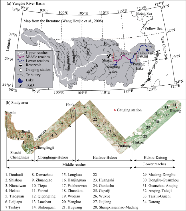
Figure 1 The Yangtze River Basin and the study area
Two main research methods were used in this study. First, the measured hydrological, topographical, geological, and remote sensing data were systematically analyzed to acquire the control factors. The detailed method was as follows: using the latest aerial photos, the curvature radius of the river bend was directly measured, and the location and the protruding length of the node could also be measured. The hydraulic geometry of the typical cross-section and the channel longitudinal gradient were calculated using the observed channel topography data of 2011 or 2013. According to the data of riverbed material in 2003-2009, the median diameter of bed sediment of each river reach can be obtained to indicate the erosion resistance factor of riverbed. The geological structure of the concave bank of each river reach from the bankfull water level to the thalweg (the connection line of the lowest point of each topographic cross-section) elevation was systematically summarized, and the clay content of each soil layer was acquired from the test results of physical and mechanical properties. The river bank erosion resistance factor was determined by the weighted average calculating of the thickness of each soil. Through the above methods, the similarities and differences between the barrier and non-barrier river reach were compared and analyzed from the planar, cross-sectional, longitudinal profile, and riverbed and river bank perspectives; thus the control factors of barrier river reach could be dissected.
Secondly, the formula of the bending radius of flow dynamic axis was derived using the mathematical method, starting from the NS equations, which was half experiential and half theoretical. Then, the contrast relationship between the migration force of the main stream and the constraint force of the channel boundary was stretched out. Consequently, the mechanism of barrier river reach was clarified by verifying the effect of the above control factors on the barrier river reach, combining the observed hydrological, topographical, and geological data.

2.2 Data sources

Aerial photographs from the Landsat satellite digital products of 2016 could be available at the U.S. Geological Survey website (https://www.usgs.gov/ The Chinese mirror website is: http://www. gscloud.cn/). The fielded channel topographical data came from Wuhan University. The data on geological structures and clay contents of the river bank came from the Geological Survey Reports of various embankment sections in the MLYR, and were compiled by the Hubei Provincial Water Resources and Hydropower Planning Survey and Design Institute. The riverbed material data were provided by the Tianjin Research Institute for Water Transport Engineering. The 34 investigated river reaches are distributed in Shashi- Chenglingji Reach, Chenglingji-Wuhan Reach, Wuhan-Hukou Reach, and Hukou-Datong Reach respectively, whose river patterns include both the straight and meandering rivers with single-thread channels, and thus having strong representativeness. Their basic situation and the control factors of barrier are shown in Table 1.
Table 1 Barrier control factors of single-thread reaches in the middle and lower Yangtze River
Reach No. Reach name
(Abbreviation)
Reach length
(km)
Distance from Yichang (km) River pattern Presence
location of flow deflecting nodes
Hydraulic geometric coefficient Presence of barrier property
Jingjiang 1 Douhudi (DHD) 9.9 175 Single meandering Non 2.55 Yes
2 Shishou (SS) 8 234 Single meandering In the middle 2.86 No
3 Nianziwan (NZW) 15 242 Single meandering Non 4.76 No
4 Hekou (HK) 7 257 Single meandering Non 3.19 No
5 Tiaoguan (TG) 13 264 Single meandering Non 2.61 Yes
6 Laijiapu (LJP) 12 277 Single meandering Non 3.32 No
7 Tashiyi (TSY) 14 289 Single meandering Non 2.98 Yes
8 Damazhou (DMZ) 10.5 330 Single meandering In entrance 6.68 No
9 Zhuanqiao (ZQ) 9 338 Single meandering Non 3.66 Yes
10 Tiepu (TP) 12 347 Single straight Non 4.31 No
11 Fanzui (FZ) 6.5 356 Single straight Non 3.11 Yes
12 Qigongling (QGL) 7.8 380 Single meandering In the middle 3.29 No
Chenglingji-Wuhan 13 Luoshan (LS) 11 419 Single straight In entrance 6.25 No
14 Shitouguan (STG) 9 456 Single meandering In export 5.08 No
15 Longkou (LK) 9.6 483 Single meandering In export 3.42 Yes
16 Hanjinguan (HJG) 10.9 519 Single meandering Non 3.25 Yes
17 Paizhouwan (PZW) 15 542 Single meandering Non 2.14 No
18 Zhuankou(ZK) 12 610 Single straight In the middle 5.79 No
19 Wuqiao (WQ) 13 628 Single straight In entrance 4.47 No
Wuhan
Hukou
20 Yangluo (YL) 15 658 Single meandering In entrance 3.46 No
21 Huguang (HG) 10 679 Single meandering In entrance 3.93 No
22 Bahe (BH) 9.4 723 Single straight In entrance 4.52 No
23 Huangshi (HS) 15.5 753 Single meandering In export 2.70 Yes
24 Guniusha (GNS) 17 773 Single meandering In entrance 4.07 No
25 Gepaiji (GPJ) 15 802 Single meandering Along both
banks
0.79 Yes
26 Wuxue (WX) 13 830 Single meandering In entrance 4.87 No
27 Jiujiang (JJ) 16 853 Single meandering Non 3.17 No
Hukou-
Datong
28 Shangxiasanhao-
Madang (SXSH-MD)
6 938 Single meandering In export 2.05 Yes
29 Madang-Dongliu (MD-DL) 8 972 Single meandering Non 2.96 Yes
30 Dongliu-Guanzhou (DL-GZ) 9 995 Single meandering In the middle 3.47 No
31 Guanzhou-Anqing (GZ-AQ) 16 1023 Single meandering In the middle 2.71 No
32 Anqing-Taiziji (AQ-TZJ) 8.4 1054 Single meandering In export 1.71 Yes
33 Taiziji-Guichi (TZJ-GC) 10.5 1078 Single meandering Non 4.16 No
34 Datong (DT) 16 1101 Single straight In entrance 4.29 No

3 Analysis of control factors of barrier properties

3.1 Planar control factors

As can be seen from Table 1, the Tiepu, Luoshan, Zhuankou, Wuqiao, Bahe, and Datong reaches are the single-thread straight reaches. Owing to the wider channels, it is difficult to restrict the changes of the incoming flow directions caused by the adjustments of upstream river regime. Along with the periodically repetitious evolution of the staggered point bar, their flow dynamic axes move upstream or downstream drastically. In contrast, the sinuosities of the Tiaoguan, Tashiyi, and Fanzui reaches are relatively greater; the variation amplitudes of the outflow directions of these river reaches caused by the different incoming flow directions or different flow levels can be limited to a smaller extent, so that these river reaches are effective for restricting the dynamic axes. In the 34 single-thread reaches of Table 1, only the single-thread meandering reaches may have barrier properties, yet the single-thread straight reaches do not have barrier properties, showing that the planar morphology of single-thread meandering is one of the control factors shaping the barrier river reach and blocking the river regime adjustment further downstream.
The nodes in the middle and lower Yangtze River include the rocks protruding from the river bank, cement nozzle, and several years-old aggradational clay layers. The unilateral node distributed in the upper or middle part of the river reach alters the continuities of the planar and transversal morphologies, causing a violent mutation of the bending radius of the flow dynamic axis. After the upstream channel adjustment, the angle of the incoming flow exerting on the node will change, and the proximity degree of the flow dynamic axis to the node will also change (Liu et al., 2015), altering the intensity of the node deflecting flow, resulting in a great variation of the direction of the dynamic axis of outflow.
There are also a large number of bilateral nodes distributed in the middle and lower Yangtze River. As a river channel boundary has greatly resistance to the erosion of water flow, the bilateral nodes are favorable for limiting the channel widening and controlling the integral morphology of the channel (Luo et al., 1987; Qian et al., 1989). However, due to that the different nodes have different deflecting flow strengths, if the upstream river regime changes, there will be a strength difference when the bilateral nodes deflect flow alternately. The geological compositions of the both banks in downstream river are also different, thus the main stream line will migrate and the river regime will be altered. For example, the YangLin Node and the Longtou Mountain are distributed bilaterally at the entrance of the Luoshan Reach. Due to the different strengths of deflecting flow of the two nodes (Leng, 1993), the downstream main stream lines migrate frequently, and taking into account the weak erosion resistance of the river bank of the downstream Jiepai Reach, both the broadening of the channel and the amplifying of the migration amplitude of the main stream line may occur (Liu et al., 2014). This kind of river reach does not have barrier properties. The Wuqiao Reach with the Turtle and Snake Mountains at its entrance also has similar characteristics.
Some river reaches with bilateral nodes at the entrance are relatively stable, such as the Bailuo and Daoren Nodes distributed in the Nanyang Reach, and the Shamao and Tieban Nodes distributed in the Tieban Reach. The stabilities of their river regimes are dependent on the long-term stabilization of their upstream river regimes, such as in the case of the Guanyin and Meitan reaches, which respectively provides stable planar locations for the incoming flow of the downstream Nanyang and Tieban reaches, resulting in only minor changes in the deflecting flow strengths of the nodes. Therefore, the stabilization of their river regimes depends on the stabilization of their upstream river regimes. Once the upstream river regime is adjusted by the artificial and natural disturbances, the river regime of this reach will be adjusted accordingly. However, it is difficult to maintain the narrow and deep cross-section to restrict the migration of the main stream line after the river regime adjustment at the entrance which is caused by the difference in the deflecting flow strengths of the bilateral nodes (Leng, 1993) or the difference of the geological and geomorphological conditions of both bank sides of downstream (Yu, 1984). Thus, the river reaches with bilateral nodes usually do not have barrier properties.

3.2 Cross-sectional control factors

It is difficult to prevent the flow dynamic axis from migrating in the wider channels, and floodplains are generally known to occur in their vicinity (Ramos and Gracia, 2012; Clerici et al., 2015). When water overflows from the deep channel and enters the floodplain, the channel width increases abruptly, and the hydraulic geometric coefficient ζ (where ζ= B is river width, h is river depth) also increases significantly (Regalla et al., 2013), providing sufficient migrating space for the flow dynamic axis. At this time, the upper river regime adjustment is bound to cause the migration of the flow dynamic axis and propagate downstream.
Figure 2 depicts the typical cross-sections of each river reach, in order to be more obvious, the thalweg of the narrow and deep cross-sections are drawn on the left side of the dividing line in this figure, and other cross-sections are drawn on the right side of the dividing line. It is seen that on the left side of the dividing line, the river reaches with narrow and deep cross-sections, including the Douhudi, Tiaoguan, Tashiyi, Zhuanqiao, Fanzui, Longkou, Hanjinguan, Huangshi, Gepaiji, Shangxiasanhao-Madang, Madang-Dongliu, and Anqing-Taiziji reaches, all of which have barrier properties. Their average hydraulic geometric coefficients ζ under different flow levels are all smaller than 4. With the increase of the flow level, the river width increases less but the water depth increases more, thus maintaining the flow dynamic axis stable and preventing the upstream channel adjustment from transferring downstream. Besides the straight reaches and the reaches with nodes, the Nianziwan, Damazhou, Shitouguan, and Taiziji-Guichi reaches, whose average hydraulic geometric coefficients under different flow levels are greater than 4, have no barrier properties. Thus, ζ<4 is also one of the control factors in the formation of barrier river reaches and in the blocking process of the upstream channel adjustments propagating downstream.
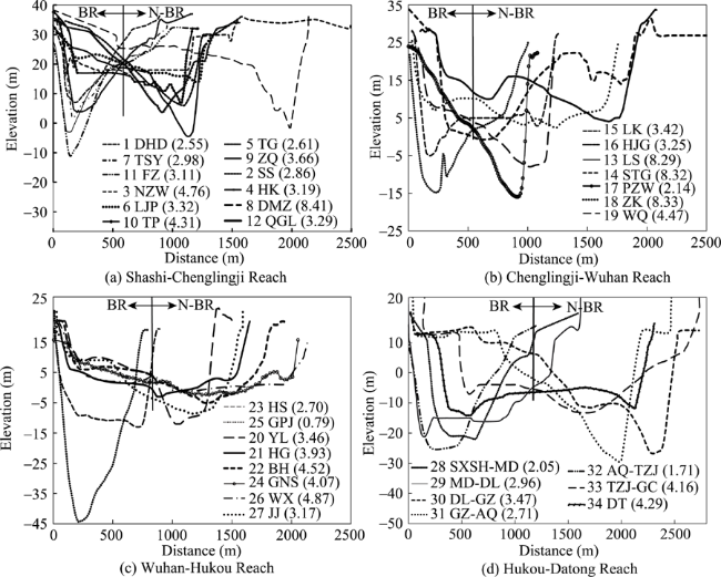
Figure 2 The configurations of the typical cross-section of the single-thread reaches in the middle and lower Yangtze River

Note: BR means barrier river reaches, and N-BR means non-barrier river reaches in the above figure.

3.3 Longitudinal profile control factors

For the river reaches with the positive slopes, whose thalweg elevation at the entrance is higher than at the export, the steeper the river longitudinal profile, the greater the channel longitudinal gradient. The strong suction effect at the export of river reach concentrates the flows from different upstream directions and prevents the flow dynamic axis from migrating. There are two kinds of manifestations: One is the scour holes at the export of the river reach caused by the nodes deflecting flow, such as in the Longkou, Huangshi, and Gepaiji reaches. The other is the scour holes formed by the circulation effect of the concave bank of the river bend, such as in the Tiaoguan, Fanzui and Hanjinguan reaches. The river reaches with negative slopes, or the reaches having backwater effects caused by tributaries confluences at the exports, usually do not possess barrier properties. Statistics show that (Figure 3), except for the reaches with straight morphologies, or the flow deflecting nodes, or ζ >4, in the remaining 17 single-thread reaches, only the Qigongling, Paizhouwan, and Jiujiang reaches have no barrier properties because their channel longitudinal gradients are less than 12‰, while all the other 14 reaches have gradients greater than 12‰. This shows that the channel longitudinal gradient greater than 12‰ is also one of the influencing factors in the formation of barrier river reach and in the blocking process of the upstream river regime adjustments propagating downstream.
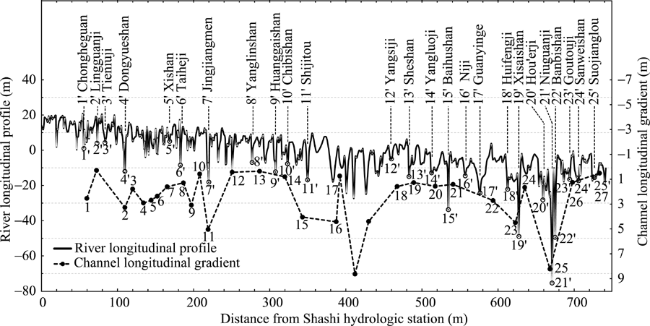
Figure 3 The channel longitudinal gradients of the single-thread reaches and the longitudinal profile of the middle and lower Yangtze River

3.4 Riverbank and riverbed control factors

Julian and Torres (2006) considered the erosion resistance to be proportional to the silty clay content. Figure 4 shows the clay contents of the concave banks and the median diameters of the bed materials. Out of the remaining 14 river reaches, only the clay contents of the concave banks of the Hekou and Laijiapu reaches are lower than 9.5%, having no barrier properties, while the other 12 river reaches are higher than 9.5%. Only the median diameter of the bed material of the Hekou Reach is finer than 0.158 mm, having no barrier property, while the other 12 river reaches are coarser than 0.158 mm. It is thus clear that only the river bank having stronger erosion resistance can block the collapse or the broadening of the channel. The river reach itself can maintain a stable river regime and make the meandering morphology and the narrow and deep cross-section unchanged, so as to restrict the migration of flow dynamic axis. Only when the riverbed sediment is coarser, the erosion resistance is stronger, and the moving bed resistance is larger; the configuration of the point bar and pool in this reach will be difficult to change (Wohl, 2015), and it will be difficult for the flow dynamic axis to migrate drastically. Thus the control factors on the formation of the barrier river reach also include that the clay content of concave bank is higher than 9.5%, and the median diameter of bed sediment is coarser than 0.158 mm. It is worth noting that the accumulated bank protection volume is, on average, 189.1 m3/m in barrier reaches, but only 126.9 m³/m in non-barrier reaches, illustrating that the natural geological conditions of the river banks in some barrier reaches have relatively weaker erosion resistances, such as in the case of the Tiaoguan, Tashiyi, Zhuanqiao, and Fanzui reaches. To counteract the weaker erosion resistances of their river banks, their volumes of bank protection are greater, so as to ensure the overall stronger resistances to the erosion of water flow.
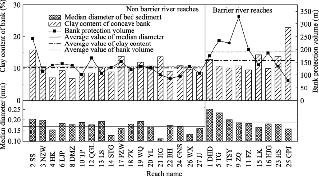
Figure 4 The river bank clay content and the median diameter of bed sediment of the single-thread reaches in the middle and lower Yangtze River

4 Analysis of mechanism of river reach barriers

Studies (You et al., 2016) showed that the essence of the downstream propagating of the river regime adjustment is the downstream propagating of the change of planar position of the main stream line. The above analysis showed that only the single-thread river bend could have barrier properties, and the bending radius of the flow dynamic axis can reflect the planar position of the main stream line of the natural river bend very well. Thus, the migration of the main stream line is reflected by the change of the bending radius of the flow dynamic line. Based on this, in this section, the bending radius of the flow dynamic axis is deduced, the effects of the above control factors on the barrier properties are analyzed, and the mechanism of the barrier river reach is also clarified.

4.1 The theoretical solution for the bending radius of the flow dynamic axis

4.1.1 Formula derivation
The expression for the three-dimensional flow dynamic equations such as the Navier-Stokes equation (Domenichini and Baccani, 2004) is as follows:
$\frac{\partial {{u}_{i}}}{\partial t}+{{u}_{j}}\frac{\partial {{u}_{i}}}{\partial {{x}_{j}}}=-\frac{1}{\rho }\frac{\partial p}{\partial {{x}_{j}}}+\frac{1}{\rho }\frac{\partial }{\partial {{x}_{j}}}\left( \mu \frac{\partial {{u}_{i}}}{\partial {{x}_{j}}} \right)-\frac{\partial }{\partial {{x}_{j}}}\left( \overline{{{{{u}'}}_{i}}{{{{u}'}}_{j}}} \right)$ (1)
Neglecting the turbulent diffusion term and non-constant term, and the bottom resistance term commonly using the item of $\frac{g{{n}^{2}}}{{{h}^{{1}/{3}\;}}}u\sqrt{{{u}^{2}}+{{v}^{2}}}$, the two-dimensional steady flow dynamic equation under the polar coordinate can be deduced as follows:
$\frac{u}{R}\frac{\partial u}{\partial \varphi }+v\frac{\partial u}{\partial R}+\frac{uv}{R}=-\frac{1}{\rho R}\frac{\partial p}{\partial \varphi }+g{{J}_{\varphi }}-\frac{g{{n}^{2}}}{{{h}^{{4}/{3}\;}}}u\sqrt{{{u}^{2}}+{{v}^{2}}}$ (2)
where φ and R are the sinuosity of the bend (in radians) and the bending radius at the perpendicular line, respectively. u and v are the average velocity of the perpendicular line at $({{\varphi }_{0}},{{R}_{0}})$, respectively. Jφ is the water surface longitudinal gradient, h is the water depth at the perpendicular line, p is the hydrodynamic pressure, g is the acceleration due to gravity, and ρ is the density of water. Then, the Manning Formula and the Chezy Coefficient are taken into the bottom resistance term:
$\frac{g{{n}^{2}}}{{{h}^{{4}/{3}\;}}}u\sqrt{{{u}^{2}}+{{v}^{2}}}=\frac{g{{u}^{2}}}{h{{C}^{2}}}$ (3)
Considering that the transverse flow velocity is much smaller than the longitudinal flow velocity, the terms with v are ignored. Given that the hydrodynamic pressure is generated by the wall shear stress, p can be expressed as the integral form of the wall shear stress τ (N²/m) along the perpendicular line, $p=-\int_{z=0}^{z=\varsigma }{\tau dz=-}\tau h$, then Eq. 3 can be transformed into:
$\frac{1}{2Rg}\frac{\partial {{u}^{2}}}{\partial \varphi }=\frac{1}{\rho gR}\frac{\partial \left( \tau h \right)}{\partial \varphi }+{{J}_{\varphi }}-\frac{{{u}^{2}}}{h{{C}^{2}}}$ (4)
Yin (1965) summarized a better relationship between the riverbed roughness and the downstream limit particle size of the coarsening layer as $n={{{d}^{{1}/{6}\;}}}/{21=0.048}\;{{d}^{{1}/{6}\;}}$, according to the measured data and flume test data. Xu (1997) believed that the relationship between the critical scour shear stress of the riverbed ${{\tau }_{c}}$ and the clay content of the bed material M0 was basically proportional, ${{\tau }_{c}}=0.254M_{0}^{0.99}$, according to the 16 groups of test data of Dunn (1959). But Lane (1959) discovered that the shear stress near the river banks is close to 0.76 times the shear stress near the riverbed, so the wall shear stress is expressed as $\tau =0.193{{M}^{0.99}}$, where M is the clay content of the bank.
Taking the Chezy coefficient $C={{h}^{{1}/{6}\;}}/n$ into account, $C=21{{(h/d)}^{{1}/{6}\;}}.$ Eq. 5 shows the substitution of the above results into Eq. 4:
$\frac{1}{2Rg}\frac{\partial {{u}^{2}}}{\partial \varphi }=\frac{1}{\rho gR}\frac{\partial \left( 0.193{{M}^{0.99}}h \right)}{\partial \varphi }+{{J}_{\varphi }}-\frac{{{u}^{2}}{{d}^{{1}/{3}\;}}}{441{{h}^{{5}/{3}\;}}}$ (5)
Then, u2 is solved using a first order ordinary differential equation, assuming that all the hydraulic factors in the curve do not change significantly within a certain flow pathway. The flow velocity average along the perpendicular line at the entrance of the river bend is approximated as $u={Q}/{(Rh\cdot \ln ({{{R}_{2}}}/{{{R}_{1}}}\;))}\;$ (Zhang, 1984). Considering that the river width (B) is smaller than the curvature radius of the curve (R*) in most cases, $\ln \frac{{{R}_{2}}}{{{R}_{1}}}=\frac{B}{{{R}_{*}}}$, $u={{\left. \frac{{{R}_{*}}Q}{RBh} \right|}_{\varphi =0}}$, and u can be expressed as:
$u=\sqrt{N\cdot S+\left[ {{\left( \frac{{{R}_{*}}Q}{RBh} \right)}^{2}}-N\cdot S \right]{{e}^{-\frac{2gR\varphi {{d}^{{1}/{3}\;}}}{441{{h}^{{4}/{3}\;}}}}}}$ (6)
where $N=J+\frac{0.193{{M}^{0.99}}h}{gR\rho },$$S=\frac{441{{h}^{{4}/{3}\;}}}{{{d}^{{1}/{3}\;}}}.$ Given that the water flow velocity, the water depth, and the water surface longitudinal gradient, all achieve their maxima at the flow dynamic axis, ${{\left. \frac{\partial u}{\partial R} \right|}_{R={{R}_{0}}}}=0$, ${{\left. \frac{\partial J}{\partial R} \right|}_{R={{R}_{0}}}}=0$, ${{\left. \frac{\partial h}{\partial R} \right|}_{R={{R}_{0}}}}=0$. The hydraulic geometric coefficient is introduced by $\varsigma ={\sqrt{B}}/{h}\;,$ accordingly, $B\cdot h$=ζ2 h3.
Taking the derivative of R in Eq. 6, the mathematical expression directly describing the variation in the bending radius of the flow dynamic axis can be derived:
${{\left( \frac{{{R}_{*}}Q}{{{\varsigma }^{2}}h_{0}^{3}} \right)}^{2}}\frac{1}{R_{0}^{3}}+{{\left( \frac{{{R}_{*}}Q}{{{\varsigma }^{2}}h_{0}^{3}} \right)}^{2}}\frac{1}{R_{0}^{2}}\frac{g\varphi {{d}^{{1}/{3}\;}}}{441h_{0}^{{4}/{3}\;}}-\frac{{M}'g\varphi {{d}^{{1}/{3}\;}}}{\rho h_{0}^{{1}/{3}\;}}-g{{J}_{0}}\varphi =0$ (7)
where ${M}'=0.0009{{M}^{0.99}}$. The theoretical equation of R0 at the flow dynamic axis line can be solved by Eq. 7:
${{R}_{0}}={{\left[ \frac{R_{*}^{2}{{Q}^{2}}\rho }{\varphi g{{\varsigma }^{4}}h_{0}^{5}(\rho Jh_{0}^{{2}/{3}\;}+{M}'{{d}^{{1}/{3}\;}})} \right]}^{{1}/{3}\;}}$ (8)
The middle and lower Yangtze River, where the Dongting Lake, Poyang Lake, Hanjiang River and other tributaries converge into the trunk stream of the Yangtze River along the flow pathway, is largely alluvial; thus the annual and interannual variation amplitude of flow is very large (Xia et al., 2016; Mossa, 2016). Therefore, $\frac{{{Q}_{\max }}-{{Q}_{\min }}}{{{Q}_{\max }}}$ is added to represent the role of the variation amplitude of the flow rate on the flow dynamic axis.
Secondly, the larger the relative length of the node protruding from the river bank line, the greater the constriction degree of the river width, the stronger the deflecting flow capacity of the node, and the larger the migration magnitude of the flow dynamic axis. Thus $\lambda =\frac{{{B}_{bankfull}}-{{L}_{node}}}{{{B}_{bankfull}}}$ is taken to indicate the influence of the deflecting flow strength of the node. For the same node, the strength of deflecting flow changes when the flow level changes. Under different flow levels, the proximity degree of the flow dynamic axis to the node is usually different; thus the deflecting strength of the node is different too. The smaller the value of λ, the more sensitive the node’s response to the change of incoming flow level, so 1/λ is taken as the coefficient of the variation amplitude of the flow.
${{R}_{0}}={{\left[ \frac{R_{*}^{2}{{\left( \frac{Q}{\lambda }\cdot \frac{{{Q}_{\max }}-{{Q}_{\min }}}{{{Q}_{\max }}} \right)}^{2}}\rho }{\varphi g{{\varsigma }^{4\lambda }}h_{0}^{5}\left( \rho Jh_{0}^{{2}/{3}\;}+{M}'{{d}^{{1}/{3}\;}} \right)} \right]}^{{1}/{3}\;}}$ (9)
where Qmax and Qmin are the maximal and minimal flow rates of the river reach, respectively; Bbankfull is the bankfull river width, and Lnode is the protruding length of the node from the river bank line. It should be noted that although Eq. 9 is deduced from the NS equation, the empirical formulas are also used in the derivation procedure, making Eq. 9 a semi-empirical semi-theoretical formula.
4.1.2 Analysis of the formula rationality
Numerous scholars (Zhang et al.,1983; Zhang et al.,1984; Qian, 1987) have done extensive researches on the formulas of the bending radius of the flow dynamic axis in the river bend, and put forward many semi-empirical semi-theoretical or empirical formulas. All of them considered that the bending radius of the flow dynamic axis was positively correlated with the flow rate, which was consistent with the general regularity of “the flow dynamic axis went straight during floods, but bent during the dry season”. It can be seen that the bending radius of the flow dynamic axis derived in Eq. 9 was also positively correlated with the flow rate, which was in accordance with the existing researches.
At the same time, the existing research (Yu et al., 1987; Luo et al., 1989; Leng et al., 1993; Li et al., 2012; Liu et al., 2015; You et al., 2016) gradually recognized the important role of the flow deflecting node on the fluvial process. Based on this, Eq. 9 considers the effect of the node, which is the main difference comparing with the existing research results. In order to verify the rationality of Eq. 9, taking the Guniusha Reach as an example, the bending radii of the flow dynamic axis at several typical cross-sections under different flow levels are calculated using both Eq. 9 and the existing other formulas. The comparisons of their results with the measured values are shown in Table 2 and Figure 5. It can be seen that the results from Eq. 9 are more consistent with the measured values, indicating that Eq. 9 is more suitable for the calculation of the bending radius of the flow dynamic axis when there is flow deflecting node distributed at the entrance of the river reach, as in the case of the Guniusha Reach.
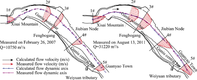
Figure 5 The verification of the flow dynamic axis calculated by Eq.9 in the Guniusha Reach
Table 2 The comparison of the formula results with the measured values in the Guniusha Reach

4.2 Analysis of mechanism of river reach barriers

4.2.1 Mechanisms of various control factors barriers
Eq. 9 could be transformed as:
$\frac{{{R}_{0}}}{{{R}_{*}}}=\frac{{{\left[ {{\left( \frac{Q}{\sqrt{{{R}_{*}}}}\cdot \frac{{{Q}_{\max }}-{{Q}_{\min }}}{\lambda {{Q}_{\max }}} \right)}^{2}}\frac{{{\varsigma }^{\left( 5-4\lambda \right)}}}{\varphi } \right]}^{{1}/{3}\;}}}{{{\left[ g{{B}^{{5}/{2}\;}}\left( Jh_{0}^{{2}/{3}\;}+\frac{{M}'{{d}^{{1}/{3}\;}}}{\rho } \right) \right]}^{{1}/{3}\;}}}\approx \frac{{{F}_{migration}}}{{{F}_{constraint}}}=\frac{{{F}_{m}}}{{{F}_{c}}}$ (10)
where the term of R0/R* on the left side can be used to indicate the constraint effect of curvature radius of the river bend on the bending radius of the flow dynamic axis. Obviously, the smaller this value, the greater the constraint effect of the curvature radius of the river bend on the bending radius of the flow dynamic axis. Then the smaller the migration amplitude of the main stream line, the more likely for the river reach to have barrier properties.
If the flow process is constant, the planar position of the flow dynamic axis will not change with the temporal and spatial variation, and there will be no adjustment for the river regime. Thus, the change of the flow process is a dynamic factor which promotes the migration of the flow dynamic axis. Analyses of Chapter 3 of Qian’s work (1987) show that the flow deflecting nodes distributed in the upper or middle parts of the river reaches exacerbates the migration amplitudes of the flow dynamic axes under different flow levels. For the straight river reach with an undersized sinuosity, in which the difference between the curvature radius of the river bend and the bending radius of the flow dynamic axis is large, the concentrating action of the river reach on the flow dynamic axis will be weakened (Qian, 1987). The wide and shallow cross-section with an oversized hydraulic geometric coefficient often provides a larger migration room for the flow dynamic axis, while the smaller altitudinal difference between point bar and pool will also be beneficial for the chute cutoff. Thus, the variability of the flow process, the existence of the flow deflecting node, the small sinuosity of the river bend, and the large hydraulic geometric coefficient all promote the migration of the flow dynamic axis. The numerator on the right side of Eq. 10 can be taken as the migration force of the flow dynamic axis.
Analyses of Chapter 3 show that, when the channel longitudinal gradient magnifies, the stream power per unit width will increase, leading to the erosion and deposition of the deep channel, thereby facilitating the restriction of the lateral shift of the flow dynamic axis. The river bank with the higher clay content has stronger resistance to the erosion of water flow, and thus is beneficial in shaping the cross-section with narrow and deep configuration and in reducing the lateral moving space of the flow dynamic axis. When the riverbed sediment is coarser, the riverbed has greater resistance to the erosion of the water flow, and to a certain extent, resulting in the reduction of the migration amplitude of the flow dynamic axis. Therefore, a large channel longitudinal gradient, with the strong erosion resistances of the river bank and the riverbed can restrict the migration of the flow dynamic axis. The denominator item on the right side in Eq. 10 can be seen as the constraint force of the channel boundary.
In the above analysis, the right side of Eq. 10 approximately reflects the contrasting relationship between the migration force of the flow dynamic axis and the constraint force of the channel boundary, and macroscopically, manifests the contrasting relationship between the bending radius of the flow dynamic axis and the curvature radius of the river bend. It is thus evident that the above formula structure is reasonable. The function of the control factors on promoting or restricting the migration of the flow dynamic axis that is analyzed in Chapter 3 is reasonable too.
In order to further analyze the influence degrees of different control factors on the migration of the flow dynamic axis, sorting out the variation ranges of each control factor is done as follows: the flow level is in the range of 4000-80,000 m³/s, the curvature radius of the river bend is 2000-16000 m, the hydraulic geometric coefficient is 0.8-6.7, the relative length of the node protruding from the river bank line is 0.67-1.0, the channel longitudinal gradient is 4‰-82‰, the median diameter of bed material is 0.112-0.251 mm, and the clay content of the concave bank is 6.9%-22.8%. Therefore, making any control factor in the above-mentioned range relatively changed and other control factors in their own average value unchanged, the sensitivity of the Ψ to the relatively change of the each control factor can be analyzed and shown in Figure 6.
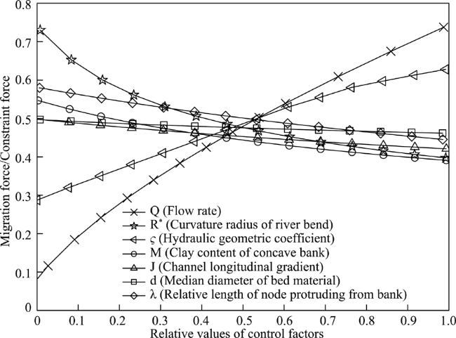
Figure 6 Sensitivity analysis of the influences of various control factors on the barrier river reaches
As shown in Figure 6, Fm/Fc is directly proportional to Q and R*, but inversely proportional to ζ, λ, M, J and d. The absolute values of the gradients of the correlation curves show a variation regularity of $Q>\varsigma >R{}_{*}>\lambda >M>J>d$. Firstly, the change of Q is bound to cause the migration of the flow dynamic axis, and only the cross-section with deep and narrow configuration can have greater constraint force to restrict the migration of the main stream line. This is an essential element in the formation of the barrier river reach. Secondly, the planar morphology of single-thread and meandering without the flow deflecting node in the upper and middle part of the river reach can form the cross-section which is reciprocally adaptive to the water flow, thereby restricting the migration of the main stream line. Only the river reach whose river bank has greater erosion resistance can maintain the long-term narrow and deep cross-section. Again, the steep channel longitudinal gradient and the coarse riverbed median diameter are propitious in concentrating the water flow into deep channels and letting them down, thereby reducing the lateral shift of the main stream line. Therefore, the six control factors above-mentioned in the final analysis together shape a narrow and deep cross-section to constrain the migration of the main stream line. They are all essential.
4.2.2 The ratio of the migration force of the flow dynamic axis to the constraint force of the channel boundary determines the barrier properties of the river reach
According to Eq. 10, the values of $F_m/F_c$ of the 34 river reaches were calculated, and their variation trends with the changes of Q values were shown in Table 1. As shown in Figure 7, the ratios of the migration forces of the main stream to the constraint forces of the channel boundary magnifies with the increase of Q values. Combining with Table 1, it can be seen that, the ratios of the migration force to the constraint force are always less than 1 in the Douhudi, Tiaoguan, Tashiyi, Zhuanqiao, Fanzui, Longkou, Hanjinguan, Huangshi, Gepaiji, Shangxiasanhao-Madang, Madang-Dongliu, and Anqing-Taiziji reaches, which have barrier properties. It is illustrated that under different flow levels, their constraint forces of the channel boundaries are larger than the migration forces of the main streams; thereby effectively restricting the migration of the main stream line, resulting in the development of barrier properties. However, the non-barrier river reaches whose constraint forces of the channel boundaries are smaller than their migration forces of the main streams when the flow rates exceed certain values, cannot restrict the migrations of the main streams effectively, resulting in the destruction of barrier properties.
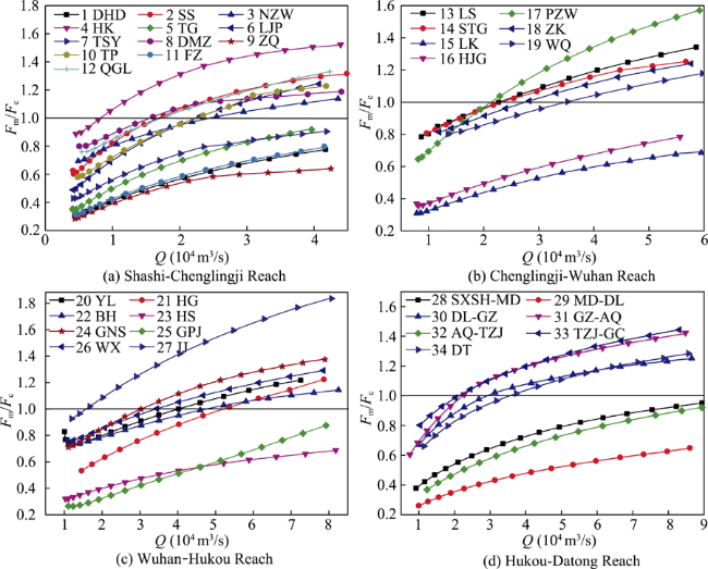
Figure 7 The ratio of the migration force of the flow dynamic axis to the constraint force of the channel boundary in the middle and lower Yangtze River
In conclusion, the mechanism of the barrier river reach is dependent on the constraint force of its channel boundary being always greater than the migration forces of the main stream under different flow levels. Even if the upstream river regime changes obviously and the direction of the incoming flow changes drastically, the channel boundary of this river reach can always restrict the planar position of the flow dynamic axis and weaken the large-scale migration of the flow dynamic axis after the upstream river regime adjusts, helping to centralize the planar positions of the flow dynamic axes, and thereby providing relatively stable incoming flow conditions for the downstream reaches.
Chapter 3 analyzes the control factors like planar, transversal, and longitudinal morphologies, and the erosion resistances of the river bank and riverbed, which are the necessary conditions for the constraint force of the channel boundary to be greater than the migration forces of the main stream. For the river reaches that do not meet one or more above conditions, with the changes of the incoming flow direction and the flow level, the constraint force of the channel boundary cannot always be greater than the migration forces of the main stream, resulting in that the planar position of the main stream line changes greatly, and the downstream river regime adjusting accordingly, thus not having the barrier properties.

5 Conclusions

The 34 single-thread river reaches were investigated on the basis of judging whether they have barrier properties or not, and the control factors of the barrier properties were contrasted and analyzed, the calculation formula of the bending radius of the flow dynamic axis was deduced, and the action mechanism of each control factor on the barrier properties was analyzed. The main conclusions are as follows:
(1) The control factors of the barrier river reach include: planar morphology of single-thread and meandering, and without flow deflecting node distributed in the upper or middle part of the river reach. The hydraulic geometric coefficient is less than 4, the channel longitudinal gradient is greater than 1.2‰, the clay content of the concave bank is greater than 9.5%, and the median diameter of the bed sediment is greater than 0.158 mm.
(2) The mechanism of the barrier river reach when the constraint force of the channel boundary is always greater than the migration forces of the main stream under different flow levels. Even if the upstream river regime changes obviously, the channel boundary of this river reach can always restrict the planar position of the flow dynamic axis, and help to centralize the planar positions of the main stream lines under different conditions of upstream river regime, thereby providing relatively stable incoming flow conditions for the downstream reaches.

The authors have declared that no competing interests exist.

[1]
Bandyopadhyay S, Ghosh K, De S K, 2014. A proposed method of bank erosion vulnerability zonation and its application on the River Haora, Tripura, India.Geomorphology, 224: 111-121. doi:10.1016/j.geomorph.2014.07.018.By integrating the individual values of those six parameters out of those eight parameters (the first two parameters remained constant for the particular study area), a bank erosion vulnerability zonation map of the River Haora, Tripura, India (23°37′–23°53′ N. and 91°15′–91°37′ E.) has been prepared. The values have been compared with the existing BEHI-NBS method of 60 spots and also with field data of 30 cross sections (covering the 60 spots) taken along a 51-km stretch of the river within Indian Territory, and we found that the estimated values are matching with the existing method as well as with field data. The whole stretch has been divided into five hazard zones, i.e. very high, high, moderate, low and very low hazard zones; and they are cover 5.66, 16.81, 40.82, 29.67, and 9.0402km, respectively.

DOI

[2]
Bawa N, Jain V, Shekhar Set al., 2014. Controls on morphological variability and role of stream power distribution pattern, Yamuna River, western India.Geomorphology, 227: 60-72. doi: 10.1016/j.geomorph.2014.05.016.Understanding the controls on the morphological variability of river systems constitutes one of the fundamental questions in geomorphic investigation. Channel morphology is an important indicator of river processes and is of significance for mapping the hydrology-ecologic connectivity in a river system and for predicting the future trajectory of river health in response to external forcings. This paper documents the spatial morphological variability and its natural and anthropogenic controls for the Yamuna River, a major tributary of the Ganga River, India. The Yamuna River runs through a major urban centre i.e. Delhi National Capital Region. The Yamuna River was divided into eight geomorphically distinct reaches on the basis of the assemblages of geomorphic units and the association of landscape, valley and floodplain settings. The morphological variability was analysed through stream power distribution and sediment load data at various stations. Stream power distribution of the Yamuna River basin is characterised by a non-linear pattern that was used to distinguish (a) high energy ‘natural’ upstream reaches, (b) ‘anthropogenically altered’, low energy middle stream reaches, and (c) ‘rejuvenated’ downstream reaches again with higher stream power. The relationship between stream power and channel morphology in these reaches was integrated with sediment load data to define the maximum flow efficiency (MFE) as the threshold for geomorphic transition. This analysis supports the continuity of river processes and the significance of a holistic, basin-scale approach rather than isolated local scale analysis in river studies.

DOI

[3]
Clerici A, Perego S, Chelli Aet al., 2015. Morphological changes of the floodplain reach of the Taro River (Northern Italy) in the last two centuries.Journal of Hydrology, 527: 1106-1122.doi:10.1016/j.jhydrol.2015.05.063.In contrast with the results of other studies, the most recent evolutionary trend of the Taro River shows substantial morphological stability with possible slight narrowing. The identification of the variations along the channel, facilitated by the analysis of the parameter curves and supported by the historical documentation, reveals that these variations can be substantially attributed to human activities. In particular, the continuous narrowing is largely due to the recurrent subtraction of riverbed areas to be used for agricultural and industrial purposes, as well as to the construction of 10 bridges with the relevant bank protections. The intense mining between 1950s and 1980s seems to have caused a sharp incision and partial narrowing only. The morphological changes due to the reduction in the flow regime, which seem to emerge from the sporadic and discontinuous hydrological data, are expected to be negligible and, in any case, are immaterial when compared with the remarkable changes due to human activities.

DOI

[4]
Domenichini F, Baccani B, 2004. A formulation of Navier-Stokes problem in cylindrical coordinates applied to the 3D entry jet in a duct.Journal of Computational Physics, 200(1): 177-191. doi: 10.1016/j.jcp.2004.04.002.A pseudospectral formulation of the three-dimensional Navier鈥揝tokes equations in the cylindrical system of coordinates is presented, which automatically includes the regularity conditions at the polar axis for the Fourier harmonics. The mathematical system of equations is numerically implemented using standard methods for spatial discretisation and time advancement. The method presented here for incompressible flows can be easily extended to different set of equations and to different numerical schemes of various levels of accuracy. The formulation is applied to the solution of incompressible three-dimensional entry jets in a circular duct.

DOI

[5]
Jason P Julian, Raymond Torres, 2006. Hydraulic erosion of cohesive river banks.Geomorphology, 76(1/2): 193-206. doi: 10.1016/j.geomorph.2005.11.003.This study identifies and assesses the controls on hydraulic erosion of cohesive riverbanks on a 600-m reach of an urban ephemeral stream with active bank erosion. We examined hydraulic bank erosion by separating estimated bank shear stress into four properties: magnitude, duration, event peak, and variability. The values of these independent variables were used as a bank erosion context at three transects. Stepwise regression showed that the event peak (maximum peak) of excess shear stress best predicts cohesive bank erosion at the two transects with moderate critical shear stresses (1.93–4.08 N/m 2 ), while the variability (all peaks) of excess shear stress best predicts erosion at the transect with low critical shear stress (0.95 N/m 2 ). These results suggest that the amount of hydraulic erosion of cohesive riverbanks is dictated by flow peak intensities. Finally, the results of this study were combined with results from previous bank erosion studies to produce a conceptual model for estimating bank erosion rates based on their silt–clay content.

DOI

[6]
Julian J P, Torres R, 2006. Hydraulic erosion of cohesive riverbanks.Geomorphology, 76(1/2): 193-206.This study identifies and assesses the controls on hydraulic erosion of cohesive riverbanks on a 600-m reach of an urban ephemeral stream with active bank erosion. We examined hydraulic bank erosion by separating estimated bank shear stress into four properties: magnitude, duration, event peak, and variability. The values of these independent variables were used as a bank erosion context at three transects. Stepwise regression showed that the event peak (maximum peak) of excess shear stress best predicts cohesive bank erosion at the two transects with moderate critical shear stresses (1.93–4.08 N/m 2 ), while the variability (all peaks) of excess shear stress best predicts erosion at the transect with low critical shear stress (0.95 N/m 2 ). These results suggest that the amount of hydraulic erosion of cohesive riverbanks is dictated by flow peak intensities. Finally, the results of this study were combined with results from previous bank erosion studies to produce a conceptual model for estimating bank erosion rates based on their silt–clay content.

DOI

[7]
Knighton A D, Nanson G C, 2001. An event-based approach to the hydrology of arid zone rivers in the Channel Country of Australia.Journal of Hydrology, 254(1): 102-123. doi: 10.1016/S0022-1694(01)00498-X.Channel Country rivers drain very large basins, have extremely variable annual flows, and experience very high relative flood magnitudes. Regional relationships describe how mean annual discharge, the average number and length of zero-flow periods, and event duration vary as power functions of drainage area. Flood flows ( Q 2, Q 5, Q 10, Q 20) vary in a more complex way with drainage area, relationships changing from positive to negative because of increased transmission losses in the larger catchments. An event approach based on three distinct types of event ingle, multiple, compound rovides an appropriate vehicle for analysing hydrologic variability. Single events have significantly smaller magnitudes, shorter durations and more rapid times-to-peak. Multiple events, although more akin to compound events than single ones overall, tend to occupy a middle ground, behaving more like single events at smaller runoff volumes and in smaller basins but more like compound ones at the other end of the scale. Generally there is a progressive increase in magnitude, duration, time-to-peak and level of unpredictability from single to compound events. Travel time, a more elusive variable to analyse, decreases log-linearly with increasing discharge in upper reaches but varies nonlinearly with discharge further downstream, reaching an intermediate maximum that is equated with the onset of floodplain flow.

DOI

[8]
Lane E W, 1955. Design of Stable Channels.Transactions of the American Society of Civil Engineers, 120(1): 1234-1260.

[9]
Langendoen E J, Mendoza A, Abad J Det al., 2016. Improved numerical modeling of morphodynamics of rivers with steep banks.Advances in Water Resources, 93: 4-14. doi: 10.1016/j.advwatres.2015.04.002.The flow and sediment transport processes near steep streambanks, which are commonly found in meandering, braided, and anastomosing stream systems, exhibit complex patterns that produce intricate interactions between bed and bank morphologic adjustment. Increasingly, multi-dimensional computer models of riverine morphodynamics are used to aid in the study of these processes. A number of depth-averaged two-dimensional models are available to simulate morphologic adjustment of both bed and banks. Unfortunately, these models use overly simplified conceptual models of riverbank erosion, are limited by inflexible structured mesh systems, or are unable to accurately account for the flow and sediment transport adjacent to streambanks of arbitrary geometry. A new, nonlinear model is introduced that resolves these limitations. The model combines the river morphodynamics computer models TELEMAC-2D and SISYPHE of the open source TELEMAC-MASCARET suite of solvers with the bank erosion modules of the CONCEPTS channel evolution computer model. The performance of the new model is evaluated for meander-planform initiation and development. The most important findings are: (1) the model is able to simulate a much greater variety and complexity in meander wavelengths; (2) simulated meander development agrees closely with the unified bar-bend theory of Tubino and Seminara (1990); and (3) the rate of meander planform adjustment is greatly reduced if the wavelength of alternate bars is similar to that of meanders.

DOI

[10]
Leng Kui, 1993. The evolution analysis of Chenluo Reach at the Middle Yangtze River.Journal of Sediment Research, (3): 109-116. (in Chinese)The Chenluo Reach at the middle Yangtze River is a straight braided channel, the influence of the river and lake relationship on its evolution is considerable.The evolution analysis shows: since 1950S, the river morphology of the Chenluo reach is steady, the transverse shape figure of the river upper Yanglinshan is deposition at the left side, but the right side has no obvious changes. Nanyangzhou hasn't taken place accumulated scour or deposition for many years. Because of the river's left depositing and right scouring, the Xianfenzhou merged to the left bank becoming frontage. The adjustment of the river and lake relationship and the variation of incoming water and sand made the low-flow channel occur certain deposition. Under the controlling of Chenlinji, Bailuoji-Daorenji, Yanglinshan-Longtoushan etc nodes, the thalweg sways very little above the Nanyangzhou, the main flow flows along the right distributary of the Nanyangzhou. Below the Nanyangzhou, under the influences of the variation of two distributory bifurcation of the Nanyangzhou and the deflecting action of nodes, the thalweg has a certain sway, therefore affect the scour and deposition of sand bar and the variation of the main flow.

[11]
Li Yitian, Tang Jinwu, Zhu Lingling et al., 2012. Evolution and Waterway Regulation of the Middle and Lower Yangtze River. Beijing: China Water Conservancy and Hydropower Press, 78-89. (in Chinese)

[12]
Liu Lin, Huang Chengtao, Li Minget al., 2014. Periodic evolution mechanism of staggered beach in typical straight reach of the middle Yangtze River.Journal of Basic Science and Engineering, 22(3): 445-456. (in Chinese)Abstract Staggered beach evolution process was effected by hydrodynamic condition, sediment discharge, boundary condition, beach and channel distribution. These factors had made the regime evolution of the straight reach complicated. In a case study of Jiepai Reach, we analyzed the evolution mechanism of straight reach channels. Based on river morphology and sediment transport characteristics, the staggered beach evolution characteristics had been analyzed. The evolution mechanism including hydrodynamics mechanism, sediment transport mechanism, boundary condition had been researched. Many factors that effected the staggered beach evolution had been studied, including the runoff and sediment change before and after the impoundment the three gorges reservoir, the river regulation project. The results showed that the periodic evolution of staggered beach and the straight section shape in Jiepai Reach will continue in the future, nevertheless the periodic time will become longer. It indicated that we should take more consider of time point as well as space point in our future project plans.

DOI

[13]
Liu Ya, Wang Fei, Li Yitian, 2015. Objective river pattern of waterway regulation of goose-head-shaped anabranching channel in the Middle and Lower Yangtze River.Journal of Hydraulic Engineering, 46(4): 443-451.Problems on navigation of the goose-head-shaped anabranching channel (GHA for short) is extremely serious because of branches substantially shifting and altering. Controversy about objective river pattern of the GHA regulation lies in anabranching or single meandering channel. Characteristics of navigation-obstructing in GHA are summarized in this paper,and objective river pattern of waterway regulation is proposed based on cause of the riffle-pool sequence and energy conservation of waterflow in the anabranching channel. The conclusions are as follows:(1) Inlet node of the GHA amplifies range of waterflow horizontal shifting and astricts translating and extending of the branches,so retaining anabranching pattern is inevitable considering waterway regulation;(2) Maintaining significant resistance difference of the branches of GHA will meet the requirements of stability of navigation channel. On the whole, anabranching channel with a greater curvature difference calculated from inlet velocity and riverbed elevation is objective river pattern of GHA.

DOI

[14]
Luo Haichao, 1989. Characteristics of fluvial processes and stability of the braided channel in the middle and lower reaches of the Yangtze River.Journal of Hydraulic Engineering, (6): 10-19. (in Chinese)The middle and lower reaches of the Yangtze River are classified as typical braided rivers with bifurcating channels characterized by the interchanging of position between the main and branch channels. The favourable conditions of diverting more clear water and less sediment to the branch make it possible to maintain relative stability for a rather long period. Mutual alternation occurs due to the change of flow feature in upstream which causes the change in transverse gradient at the point of diversion and consequently the redistribution of flow and sediment into the branch. A comparison with some known braided rivers both in China and abroad indicates, after analysing all affecting factors, that the Yangtze River belongs to a bifurcating reach with highly developed islands and high stability. (A)

[15]
Mossa J, 2016. The changing geomorphology of the Atchafalaya River, Louisiana: A historical perspective.Geomorphology, 252: 112-127. doi: 10.1016/j.geomorph.2015.08.018.This study assesses how channel geometry of the Atchafalaya River has changed with flow variations since the 1880s by evaluating instantaneous discharge measurements that document change at superior temporal resolution and differences in thalweg values from coupled modern hydrographic surveys which document change at better spatial resolution than prior works. While structures have regulated and limited flow into the Atchafalaya since 1963, the highest values of discharge, cross-sectional area, and width at Simmesport (upstream) follow river regulation. Associated geometry data at Simmesport and Morgan City (downstream) document that mean bed and thalweg elevations have risen. Comparison of thalweg elevations on hydrographic surveys from 1963 and 2006 show pronounced local variability in bed elevation change but also reaches dominated by degradation (including the Red River and uppermost section of the Atchafalaya) near the Old River diversion. Aggradation occurs in the lower Atchafalaya, a zone where along-channel lakes are filling, flow and sediment quantities are changing in part caused by the constructed Wax Lake Outlet, and deltas have been growing in Atchafalaya Bay. Findings are relevant to river engineering and flood management, especially navigation, and help in better understanding the evolution of large distributaries and the role of human impacts.

DOI

[16]
Nanson R A, Nanson G C, Huang H Q, 2010. The hydraulic geometry of narrow and deep channels: Evidence for flow optimisation and controlled peatland growth.Geomorphology, 117(1/2): 143-154. doi:10.1016/j.geomorph.2009.11.021.At-a-station and bankfull hydraulic geometry analyses of peatland channels at Barrington Tops, New South Wales, Australia, reveal adjustments in self-forming channels in the absence of sediment load. Using Rhodes ternary diagram, comparisons are made with hydraulic geometry data from self-forming channels carrying bedload in alluvial settings elsewhere. Despite constraints on channel depths caused at some locations by the restricted thickness of peat, most stations have cohesive, near-vertical, well-vegetated banks, and width/depth (w/d) ratios of 2 that are optimal for sediment-free flow. Because banks are strong, resist erosion and can stand nearly vertical, and depth is sometimes constrained, adjustments to discharge are accommodated largely by changes in velocity. These findings are consistent with the model of maximum flow efficiency and the overarching least action principle in open channels. The bankfull depth of freely adjusting laterally active channels in clastic alluvium is well known to be related to the thickness of floodplain alluvium and a similar condition appears to apply to these swamps that grow in situ and are formed almost entirely of organic matter. The thickness of peat in these swamps rarely exceeds that required to form a bankfull channel of optimum w/d ratio for the transport of sediment-free water. Swamp vegetation is highly dependent on proximity to the water table. To maintain a swamp-channel and associated floodplain system, the channels must flow with sufficient water much of the time; they not only offer an efficient morphology for flow but do so in a way that enables bankfull conditions to occur many times a year. They also prevent the swamp from growing above a level linked to the depth of the channel. Once the channel attains the most efficient cross section, further growth of the swamp vertically is restricted by enhanced flow velocities and limited flow depths. This means that the volume of peat in such swamps is determined by the hydraulic efficiency of their channels. The development and maintenance of the hydraulic geometry of these swamp channels is biogeomorphic and biohydraulic in nature and yet accords to the same optimising principles that govern the formation of self-adjusting channels and floodplains in clastic alluvium.

DOI

[17]
Qian Ning, Zhang Ren, Zhou Zhide, 1987. River Bed Evolution. Beijing: Science Press, 127-140. (in Chinese)

[18]
Ramos Judith, Gracia Jesús, 2012. Spatial-temporal fluvial morphology analysis in the Quelite River: Its impact on communication systems.Journal of Hydrology, 49(3): 432-433. doi: 10.1016/j.jhydrol.2011.05.007.During 2008 and 2009 heavy rainfall took place around the Mazatlan County in the Sinaloa state, Mexico, with a return period (Tr) between 50 and 100 years. As a result, the region and its infrastructure, such as the railways and highways (designed for a Tr = 20 years) were severely exposed to floods and, as a consequence damage caused by debris and sediments dragged into the channel. One of the highest levels of damage to the infrastructure was observed in the columns of Quelite River railway bridge. This is catastrophic as the railway is very important for trade within the state and also among other states in Mexico and in the USA. In order to understand the impact of the flooding and to avoid the rail system being damaged it is necessary to analyse how significant the changes in the river channel have been. This analysis looks at the definition of the main channel and its floodplain as a result of the sediment variability, not only at the bridge area, but also upstream and downstream. The Quelite River study considers the integration of Geographic Information Systems (GIS) and remote sensing data to map, recognise and assess the spatio-temporal change channel morphology. This increases the effectiveness of using different types of geospatial data with in situ measurements such as hydrological data. Thus, this paper is an assessment of a 20 years study period carried out using historical Landsat images and aerial photographs as well as recent Spot images. A Digital Elevation Model (DEM) of local topography and flow volumes were also used. The results show the Quelite River is an active river with a high suspended sediment load and migration of meanders associated to heavy rainfall. The river also has several deep alluvial floodplain channels which modified the geometry and other morphological characteristics of the channel in the downstream direction. After the identification of the channel changes, their causes and solutions to control, the channel migration and the dynamics structure, a river management plan was projected not only to protect the bridge but also to provide a flood risk awareness in order to reduce the social conomical impact during a flood event.

DOI

[19]
Regalla C, Kirby E, Fisher Det al., 2013. Active forearc shortening in Tohoku, Japan: Constraints on fault geometry from erosion rates and fluvial longitudinal profiles.Geomorphology, 195(4): 84-98. doi:10.1016/j.geomorph.2013.04.029.Convexities in the longitudinal profiles of actively incising rivers are typically considered to represent the morphologic signal of a transient response to external perturbations in tectonic or climatic forcing. Distinguishing such knickzones from those that may be anchored to the channel network by spatial variations in rock uplift, however, can be challenging. Here, we combine stream profile analysis, Be-10 watershed-averaged erosion rates, and numerical modeling of stream profile evolution to evaluate whether knickzones in the Abukuma massif of northeast Japan represent a temporal or spatial change in rock uplift rate in relation to forearc shortening. Knickzones in channels that drain the eastern flank of the Abukuma massif are characterized by breaks in slope-area scaling and separate low-gradient, alluvial upper-channel segments from high-gradient, deeply-incised lower channel segments. Average erosion rates inferred from Be-10 concentrations in modern sediment below knickzones exceed erosion rates above knickzones by 20-50%. Although profile convexities could be interpreted as a transient response to an increase in rock uplift rate associated with slip on the range-bounding fault, geologic constraints on the initiation of fault slip and the magnitude of displacement cannot be reconciled with a recent, spatially uniform increase in slip rate. Rather, we find that knickzone position, stream profile gradients, and basin averaged erosion rates are best explained by a relatively abrupt spatial increase in uplift rate localized above a flat-ramp transition in the fault system. These analyses highlight the importance of considering spatially non-uniform uplift in the interpretation of stream profile evolution and demonstrate that the adjustment of river profiles to fault displacement can provide constraints on fault geometry in actively eroding landscapes. (C) 2013 Elsevier B.V. All rights reserved.

DOI

[20]
Schumm S A, 1985. Patterns of alluvial rivers.Earth and Planetary Sciences, 13(13): 5-27. doi:10.1146/annurev.ea.13.050185.000253.

[21]
Schuurman F, Kleinhans M G, Middelkoop H, 2016. Network response to disturbances in large sand-bed braided rivers.Earth Surface Dynamics, 4(1): 25-45. doi: 10.5194/esurf-4-25-2016.The reach-scale effects of human-induced disturbances on the channel network in large braided rivers are a challenge to understand and to predict. In this study, we simulated different types of disturbances in a large braided river to get insight into the propagation of disturbances through a braided channel network. The results showed that the disturbances initiate an instability that propagates in the downstream direction by means of alteration of water and sediment division at bifurcations. These adjustments of the bifurcations change the migration and shape of bars, with a feedback to the upstream bifurcation and alteration of the approaching flow to the downstream bifurcation. This way, the morphological effect of a disturbance amplifies in the downstream direction. Thus, the interplay of bifurcation instability and asymmetrical reshaping of bars was found to be essential for propagation of the effects of a disturbance. The study also demonstrated that the large-scale bar statistics are hardly affected.

DOI

[22]
Schuurman F, Shimizu Y, Iwasaki Tet al., 2015. Dynamic meandering in response to upstream perturbations and floodplain formation.Geomorphology, 253: 94-109.River meandering results from spatially alternating bank erosion and bar growth. Recent flume experiments and theory suggest that a continuous inflow perturbation is a requirement for sustained meandering. Furthermore, flume experiments suggest that bar–floodplain conversion is an additional requirement. Here, we tested the effects of continuous inflow perturbation and bar–floodplain conversion on meander migration using three numerical morphodynamic models: a 1D-model, and two 2D-models with one of them using adaptive moving grid. We focused on the interaction between bars and bends that leads to meander initiation, and the effect of different methods to model bank erosion and floodplain accretion processes on meander migration. The results showed that inflow perturbations have large effects on meander dynamics of high-sinuosity channels, with strong excitation when the inflow is periodically perturbed. In contrast, inflow perturbations have rather small effect in low-sinuosity channels. Steady alternate bars alone are insufficient to cause high-sinuosity meandering. For high-sinuosity meandering, bar–floodplain conversion is required that prevents chute-cutoffs and enhances flow asymmetry, whilst meandering with chute-cutoffs requires merely weak floodplain formation, and braiding occurs without floodplain formation. Thus, this study demonstrated that both dynamic upstream inflow perturbation and bar–floodplain conversion are required for sustained high-sinuosity meandering.

DOI

[23]
Song X L, Xu G Q, Bai Y Cet al., 2016. Experiments on the short-term development of sine-generated meandering rivers.Journal of Hydro-environment Research, 11: 42-58. doi: 10.1016/j.jher.2016.01.004.This paper presents recent works on the simulation of short-term development of sine-generated meandering river in laboratory conditions. The influences of initial system parameters on the evolution process of rivers are investigated, including control over channel sinuousness, channel width and dominant discharge, eventually leading to different results of planforms. Measurements on the bank-line, flow field, bed topography and sediment transport rate were carried out. Braided rivers are easy to produce using non-cohesive sediments in floodplains, whereas environmental temperatures and humidities could influence the fluvial process by their effects on material cohesion. Channelized rivers were obtained in the igh Flow conditions and the river corridor width was proven to be mainly connected with initial channel sinuousness and water discharge. Sickle-shaped and bamboo leaves-shaped sandbars were formed in the channels during the transformation process of meandering to braiding, the stability degree of sandbars reflects the adaption of channel morphology to hydrodynamic condition. Quantitative analysis confirms the formation of free steady bars, which manifests the free response as a downstream oscillation of the perturbation. Damping length is mainly affected by dominant discharge, channel width is the secondary factor, and channel sinuousness is the weakest factor. The wavelength of steady bars approximately equals to half of the initial streamwise wavelength. Sediment transport rate tends to increase with the increasing of channel sinuousness but stops growing due to the excessive increase of flow route and flow friction. The experiment results could be useful for verifying river pattern discriminant functions and offer a basis for further study on the morphological evolution of large-scale natural rivers, such as Yangtze River.

DOI

[24]
Sun Zhaohua, Feng Qiufen, Han Jianqiaoet al., 2013. Fluvial processes of sandbars in the junction reach of single-threaded channel to anabranching channel and its impact on navigation: A case study of the Tianxingzhou Reach of the Yangtze River.Journal of Basic Science & Engineering, 21(4): 647-655. (in Chinese)The morphodynamics features of sandbars and shoals in the junction reach of upstream single-threaded channel to downstream anabranching channel were investigated,with the systematic gauged data of both channel topography and flow and sediment transfer in the Tianxingzhou reach of the Yangtze River.Comparisons of the sandbars planforms in recent 20 years showed that the sandbody in upstream single-threaded channel migrates to the end of the Hankou point bar with an interval of 5 to 6 years,which periodically induced notable fluctuation of bar volume in the entrance reach of the downstream anabranching channel.Statistics of the flow velocity,sediment concentration and bed material in recent 5 years showed that the longitudinal main stream position and transversal flow magnitude changed periodically between flood season and dry season.As a consequence,the deformation magnitude of sandbar in the entrance reach of the anabranching channel was closely related to income flow and sediment processes.Under the two kinds of controlling factors,the sandbar volume in the entrance reach of the anabranching channel was not only fluctuating with annually changes of flow and sediment discharge,but also recurrently deposited by the periodical arrival of sandbody from upstream single-threaded straight channel.Such mechanism of morphodynamics of sand bars caused recurrent shoaling in the junction reach of upstream single-threaded channel to downstream anabranching channel.After the income flow and sediment discharge adjusted by the Three Georges Reservoir,the recurrent shoals in navigational channel will probably get deteriorated in this kinds of river reaches.

[25]
Tang Jinwu, You Xingying, Hou Weiguoet al., 2015. Fluvial processes trend of Ma’anshan reach in Lower Yangtze River.Journal of Sediment Research, 67(1): 213-221. (in Chinese)

[26]
Wang Houjie, Yang Zousheng, Wang Yanet al., 2008. Reconstruction of sediment flux from the Changjiang (Yangtze River) to the sea since the 1860s.Journal of Hydrology, 349(3/4): 318-332.The Changjiang (Yangtze River) has been effectively gauged since the 1950s and demonstrates the transformation of a river system due to intensified human activities in its drainage basin over the past 5002yr. However, the 50-yr measurements of water and sediment are inadequate to show the long-term trend of sediment flux from the river to the sea or to capture the transition from natural to human dominance over the sediment flux. In this study we used the existing water discharge and sediment load records (1950s–2005) at the Hankou gauging station, together with water discharge recorded since 1865 at the same station, to reconstruct the changes of sediment flux to the sea since the 1860s. We established rating curves between stream discharge and suspended sediment concentration from the recent 50-yr data sets, which show that human disturbances have had a substantial impact on rating parameters. The commissioning of dams and undertaking of soil-conservation works have decreased sediment supply, leading to a decrease in the rating coefficient a of the rating curve equation C s 02=02 aQ b . The decreases in suspended sediment concentration have increased the erosive power of the river, and hence increased the rating exponent b . In particular, the commissioning of the Three Gorges Reservoir in 2003 resulted in a further increase of b , and channel scour in the middle and lower reaches has increased sediment flux to the sea to a level higher than sediment supply from the upper reaches. Our results suggest that the rating curves derived from 1954 to 1968 data are appropriate for estimating sediment loads for the period from 1865 to 1953, since both were periods of minimal human disturbance. This approach provides a time series of sediment loads from 1865 to 2005 at Hankou gauging station, which yields a time series of sediment flux from the Changjiang to the sea over the past 14002yr. The estimated mean annual sediment flux to the sea between 1865 and 1968 was 6548802Mt/yr, a comparable result to the previously published estimate from Milliman and Syvitski [Milliman, J.D., Syvitski, J.P.M., 1992. Geomorphic/tectonic control of sediment discharge to the ocean: the importance of small mountainous rivers. Journal of Geology 100, 525–544] and to that from an equation proposed by Syvitski and Morehead [Syvitski, J.P.M, Morehead, M.D., 1999. Estimating river-sediment discharge to the ocean: application to the Eel margin, northern California. Marine Geology 154, 13–28]. The long-term variation of annual sediment flux from the Changjiang to the sea shows a transition from a river system mostly dominated by nature (the monsoon-dominated period, 1865–1950s) to one strongly affected by human activities (the human-impacted period, 1950s–present).

DOI

[27]
Wang Suiji, Ni Jinren, Wang Guangqian, 2000. The evolution and direction of research in fluvial sedimentology.Journal of Basic Science & Engineering, 8(4): 362-369. (in Chinese)The research in fluvial sedimentology is significant not only for theory but also for practice of mine production and flood controlling. For study workers can hold the evolution and direction of research in fluvial sedimentology, some of its research aspects are reviewed and discussed in this work. These aspects include fluvial river classification, flume simulation experiment of sedimentation, depositional model, influence factors of deposit formation and ancient channel reconstruction. Some directions based on the above are brought forward and they are: (1) Fluvial sequence stratigraphy has a wide development space. (2) The distinguish methods of different river styles need to perfect. (3) The multiple channel formation mechanism of anastomosing and anabranched rivers must be researched deep in theory and flume simulation experiment. (4) The spatial and temporal transforms of different channel patterns need to study systematically and synthetically. It is look forward to develop in the above aspects so that fluvial sedimentology can be development.

[28]
Wohl E, 2015. Particle dynamics: The continuum of bedrock to alluvial river segments.Geomorphology, 241: 192-208. doi: 10.1016/j.geomorph.2015.04.014.Particle dynamics refers to production, erosion, transport, and storage of particulate material including mineral sediment and organic matter. Particle dynamics differ significantly between the end members of bedrock and alluvial river segments and between alluvial river segments with different grain-size distributions. Bedrock segments are supply limited and resistant to change, with relatively slow, linear adjustments and predominantly erosion and transport. Particle dynamics in alluvial segments, in contrast, are transport limited and dominated by storage of mineral sediment and production of organic matter. Alluvial segments are resilient to change, with relatively rapid, multidirectional adjustments and stronger internal influences because of feedbacks between particles and biota. Bedrock segments are the governors of erosion within a river network, whereas alluvial segments are the biogeochemical reactors. Fundamental research questions for both types of river segments center on particle dynamics, which limit network-scale incision in response to base level fall (bedrock segments) and habitat, biogeochemical reactions, and biomass production (alluvial segments). These characterizations illuminate how the spatial arrangement of bedrock and alluvial segments within a river network influence network-scale resistance and resilience to external changes in relative base level, climate, and human activities.

DOI

[29]
Xia Junqiang, Deng Shanshan, Lu Jinyouet al., 2016. Dynamic channel adjustments in the Jingjiang Reach of the Middle Yangtze River.Scientific Reports, 6: 22802.Significant channel adjustments have occurred in the Jingjiang Reach of the Middle Yangtze River, because of the operation of the Three Gorges Project (TGP). The Jingjiang Reach is selected as the study area, covering the Upper Jingjiang Reach (UJR) and Lower Jingjiang Reach (LJR). The reach-scale bankfull channel dimensions in the study reach were calculated annually from 2002 to 2013 by means of a reach-averaged approach and surveyed post-flood profiles at 171 sections. We find from the calculated results that: the reach-scale bankfull widths changed slightly in the UJR and LJR, with the corresponding depths increasing by 1.6 and 1.0 ; the channel adjustments occurred mainly with respect to bankfull depth because of the construction of large-scale bank revetment works, although there were significant bank erosion processes in local regions without the bank protection engineering. The reach-scale bankfull dimensions in the UJR and LJR generally responded to the previous five-year average fluvial erosion intensity during flood seasons, with higher correlations being obtained for the depth and cross-sectional area. It is concluded that these dynamic adjustments of the channel geometry are a direct result of recent human activities such as the TGP operation.

DOI PMID

[30]
Xu Jiongxin, 1997. Study of sedimentation zones in a large sand-bed braided river: An example from the Hanjiang River of China.Geomorphology, 21(2): 153-165. doi: 10.1016/S0169-555X(97)00039-1.The concept of sedimentation zone is applied to the study of spatial and temporal variations of mid-channel bars in the middle Hanjiang River, a large sand-bed braided river in China. The river channel can be divided into alternating sedimentation zones and transport zones, the formation of which is basically controlled by local channel boundary conditions such as natural and artificial bank controls (bedrock outcrops, local hill spurs, terraces, artificial dikes and influence of tributaries). A systematic comparison between sedimentation and transport zones is made in this study, including the flow shear stress, stream power, mid-channel bar features and channel stability. The results obtained indicate that different channel boundary conditions in sedimentation and transport zones control channel width and width-depth ratio, which in turn control the reach's hydraulic and sediment transport characteristics. The storage and removal of sediment in sedimentation zones correspond to the increase and decrease of the degree to which mid-channel bars develop. When the sediment input of the channel system is altered by reservoir construction, the bed-load sediment historically accumulated is released by clear water scour, thus a macroscopic bed-load `wave' forms and moves gradually downstream. Associated with this is the complex response phenomenon of mid-channel bar evolution.

DOI

[31]
Yin Xueliang, 1965. A preliminary study on the formation cause of the bend river and the experiment of making riverbed.Journal of Geographical Sciences, 31(4): 287-303. (in Chinese)

[32]
You Xingying, Tang Jinwu, Zhang Xiaofenget al., 2016. Preliminary study on the characteristics and origin of barrier river reach in the Middle and Lower Yangtze River.Journal of Hydraulic Engineering, 47(4): 545-551. (in Chinese)Analysis of long temporal and spatial riverbed evolution data shows that the adjustment of river regime in the Middle and Lower Yangtze River (MLYR) trends to pass downstream,but it's obstructed by some kind of reaches which is called barrier river reach (BRR for short). Statistics indicates that barrier reach is generally a single-thread bend with strong resistance at the concave bank. There is no node de-flecting flow in the upper and middle reaches. In addition, BRR has narrow and deep cross-section and the change rate of river width with the water level is less than 45. Further analysis shows that the root rea-son of the barrier property lies in the ability to stabilize the mainstream planimetric positions of different flow levels. No matter how the upper river regime changes, the mainstream position of outflow basically re-mained stable, which provides relatively stable inflow conditions for the lower reaches. In the river regula-tion process, the good opportunity should be seized to shape BRR. The long river reaches without BRR should be planned and regulated systematically. The bank collapse and sandbar shrinking dramatically should be controlled timely to prevent barrier property from losing.

DOI

[33]
Yu Wenchou, 1987. Action of nodes of the braided channel at the Lower Yangtze River in the fluvial processes.Journal of Sediment Research, (4): 12-20. (in Chinese)According to analysis and statistics of nodes of braided channels at the Lower Yangtze River, it is considered that the nodes can be divided into two categories: that controling a river stretch and that controling a local bank or a branch channel. Emphasis is placed upon the role of node playing in the bed evolution of the braided channel, i.e. the effects of width-depth ratio, de length and angle of bend between two nodes of a river stretch, and the control action on the river regime. Finally the paper explains the importance of nodes on the river regulation.

[34]
Zhang Dujing, Sun Hanzhen, 1983. A preliminary study on the effect of the changes of the hydraulic conditions in bends on the river pattern of the upper and lower Jingjiang stretches of the Yangtze River.Journal of Sediment Research, 3(1): 14-24. (in Chinese)Based on the analysis of field data, the relation between the changes of the main current belt in bends and the hydraulic conditions is expounded, and an empirical formula for the radius of curvature of the main current belt in bends of the Jingjiang stretch is established. Since the characteristics of flow and sediment of the Upper and Lower Jingjiang stretches are different from each other, point bars cannot grow up in the upper stretch and it develops into braided channels in bends. While point bars can grow up stably in the lower stretch, so that caving takes place on the concave bank and sediment deposits on the convex bank,thus meandering channel is developed.

[35]
Zhang Wei, Yang Yunping, Zhang Mingjinet al., 2017. Mechanisms of suspended sediment restoration and bed level compensation in downstream reaches of the Three Gorges Projects (TGP).Journal of Geographical Sciences, 27(4): 463-480.River basin reservoir construction affects water and sediment transport processes in downstream reaches. The downstream impact of the Three Gorges Projects (TGP) has started to become apparent: (1) reduction in flood duration and discharge, and significant reduction in sediment load. Although there was some restoration in downstream sediment load, the total amount did not exceed the pre-impoundment annual average; (2) in 2003–2014, the d > 0.125 mm (coarse sand) load was restored to some degree, and to a maximum at Jianli Station, which was mainly at the pre-impoundment average. After restoration, erosion and deposition characteristics of the sediment was identical to that before impoundment. The degree of restoration during 2008–2014 was less than during 2003–2007; (3) after TGP impoundment, there was some restoration in d 0.125 mm sediment load recovered to a certain degree after impoundment, however, the total did not exceed 4400×10 4 t/y. This was mainly limited by flood duration and the average flow rate, and was less affected by upstream main stream, tributaries, or lakes. Restoration of d < 0.125 mm suspended sediment was largely controlled by upstream main stream, tributaries, and lakes, as well as by riverbed compensation. Due to bed armoring, riverbed fine suspended sediment compensation capability was weakened; (5) during 2003–2007 and 2008–2014, Yichang to Zhicheng and upper Jingjiang experienced coarse and fine erosion, lower Jingjiang experienced coarse deposition and fine erosion, Hankou to Datong had coarse deposition and fine erosion, and Chenglingji and Hankou was characterized by coarse deposition and fine sand erosion in 2003–2007, and coarse and fine erosion in 2008–2014. This difference was controlled by flood duration and number at Luoshan Station.

DOI

[36]
Zhang Zhitang, Lin Wanquan, Shen Yongjian, 1984. An approach on the main current belt of stream flow in river bend.Journal of Yangtze River Scientific Research Institute, (1): 47-56. (in Chinese)The contents in this paper are presented below: 1 . This paper mainly deals with the change of the main current belt in the river bend. From correlation analysis based on the main factors.the relationship for bend radius of the main current belt suitable for the Jingjiang reach may be stated as 2 . For approaching the expression which express the velocity of bend along the width of river, this paper presents the equation of flow movement of river bend in polar coodinates and derives the formula of the average velocity along the depth from polar equation, which is given by 3 . According to the definition of the main current belt and derivative of formula of average velocity with respect to variable R,the theoretical formula of bend radius of the main current belt is as follows. 4. In accordance with the features of flow in the river bend near the location where the main current belt directly attacks, this paper presents an expression defined as the attacking location of the main current belt, which is given by The calculated results from formults as mentioned above are primarily agreed with the field data of the bend flow.

Outlines

/