Orginal Article

Process and proposal for comprehensive regionalization of Chinese human geography

  • FANG Chuanglin , 1, 2 ,
  • LIU Haimeng 1, 2 ,
  • LUO Kui 1, 2 ,
  • YU Xiaohua 1, 2
Expand
  • 1. Institute of Geographic Sciences and Natural Resources Research, CAS, Beijing 100101, China
  • 2. College of Resources and Environment, University of Chinese Academy of Sciences, Beijing 100049, China

Author: Fang Chuanglin (1966-), PhD and Professor, specialized in urban geography, urban agglomeration and the resource and environmental effects of urbanization. E-mail:

Received date: 2017-01-07

  Accepted date: 2017-03-10

  Online published: 2017-09-06

Supported by

Major Program of the National Natural Science Foundation of China, No.41590840, No.41590842

Copyright

Journal of Geographical Sciences, All Rights Reserved

Abstract

The comprehensive regionalization of Chinese human geography is based on the rules governing regional differentiation of Chinese physical geographic factors. Based on regional differences and similarities in human factors, this study divides the whole country into two levels of relatively independent, complete and organically linked human geographic units. As a fundamental, comprehensive, cutting-edge, practical and important task, the comprehensive regionalization of human geography highlights the characteristics, regional and sub-regional features, complexity and variety of spatial differences between factors of Chinese human geography. It is capable of promoting the development of human geography based on local conditions, providing basic scientific support to national and local development strategies, such as the Belt and Road Strategy, new urbanization and environmental awareness, and creating a sound geopolitical environment in key areas. Using results from existing physical and human geographic zoning studies, and in accordance with the principles of synthesis, dominant factors, the relative consistency of the natural environment, the relative consistency of social and economic development, the consistency of the regional cultural landscape, the continuity of spatial distribution and the integrity of county-level administrative divisions, and taking as its basis the division of human geography into 10 major factors (nature, economy, population, culture, ethnicity, agriculture, transportation, urbanization, the settlement landscape and administrative divisions), this paper constructs an index system for the comprehensive regionalization of Chinese human geography through a combination of top-down and bottom-up zoning and spatial clustering analysis. In this study, Chinese human geography is divided into eight regions and 66 sub-regions. The eight human geography regions are (I) Northeast China, (II) North China, (III) East China, (IV) Central China, (V) South China, (VI) Northwest China, (VII) Southwest China, and (VIII) Qinghai and Tibet. This zoning proposal fills gaps in studies involving the non-comprehensive regionalization of Chinese human geography. Each human geography region and sub-region has different topographical, climatic, ecological, population, urbanization, economic development, settlement landscape, regional cultural and ethno-religious attributes. This proposal on the comprehensive regionalization of Chinese human geography dovetails closely with previous studies on comprehensive regionalization in Chinese physical geography, Chinese economic zoning, and Chinese agricultural zoning. It shows that, under the dual roles of nature and humans, there are certain rules of regional differentiation that govern the comprehensive regionalization of Chinese human geography.

Cite this article

FANG Chuanglin , LIU Haimeng , LUO Kui , YU Xiaohua . Process and proposal for comprehensive regionalization of Chinese human geography[J]. Journal of Geographical Sciences, 2017 , 27(10) : 1155 -1168 . DOI: 10.1007/s11442-017-1428-y

Synthesis and regional differentiation in geography have meant that geographic zoning is a traditional task of geographical research and an important part of the discipline’s development. Geographic zoning is the observation and study of a geographic entity from a regional perspective to explore the formation and development, differences and associations, divisions and amalgamations, and interrelations of spatial units. It is also a means of revealing common phenomena within regions and differences between regions, and it is the generalization and summary of processes and types of integrated research (Zheng et al., 2005). The main goal of the scientific research paradigm of geographic systems is to show the multi-factor synergistic evolution of types of geographic areas and geographic entities (Song, 2016). From ancient times, when people first attempted to create maps that separated the world, to Alexander von Humboldt, Ferdinand von Richthofen and others in modern Germany, who systematically mapped and divided Earth’s surface based on their field observations (Martin, 2005), and to the flourishing of various contemporary comprehensive regionalization and thematic zoning techniques closely related to national economies and societies with the support of GIS and big data, every step of progress in geography has been closely related to the zoning of individual or integrated geographic factors, and every breakthrough in the zoning of particular geographic factors has marked the maturity of a branch of geography and the start of a new stage in the discipline’s development. Comprehensive regionalization of physical geography, which concerns natural processes, has matured through the ages, while comprehensive regionalization of human geography, which concerns human processes, remains unexplored. Carrying out comprehensive regionalization of Chinese human geography will not only fill in blanks in the discipline of human geography, but, more importantly, it will help human geography better serve national and regional development strategies based on local conditions. At the international level, it will provide important theoretical support to serve the Belt and Road Strategy, strengthen exchanges and cooperation, and create a favorable geopolitical environment. At the domestic level, it will serve as an important theoretical basis for meeting national strategic needs, promoting new urbanization and environmental awareness based on local conditions, constructing rational patterns of urbanization, agricultural development and ecological security, and further optimizing the spatial pattern of land development.

1 Relevant advances in research on comprehensive regionalization of Chinese human geography

Although no studies have been carried out on the comprehensive regionalization of Chinese human geography to date, there have been constant developments and improvements in the zoning of individual human geographic factors in China since 1949. These zoning efforts have mainly involved the zoning of China’s administration, population, economy, industry, agriculture, transport, tourism, culture, new urbanization, settlement landscape and major functions (Zheng, 2012). Of these, due to their strong association with national social and economic development, the most studied and discussed have been the zoning of China’s economy and agriculture.
In terms of comprehensive regionalization of China’s physical geography, the previous generation of geographers achieved considerable theoretical and practical results (Huang, 1959; Ren and Yang, 1961; Zhao, 1983; Yang et al., 2005). Since the 1990s, the purpose of zoning has changed to meet the needs of sustainable development, which has meant less research into human and economic zoning. As a result, in his later years, renowned Chinese geographer, Huang Bingwei, staunchly advocated studying the comprehensive regionalization of both human and physical factors (Huang, 1998). Later, Ge Quansheng, Wu Shaohong, Liu Junhui and others made initial attempts at the comprehensive regionalization of China’s land surface system as well as the Qaidam Basin and the Qinghai-Tibet Plateau (Huang, 1998; Ge et al., 2003; Wu and Liu, 2005; Liu and Fu, 2005; Wu et al., 2010). A relatively influential study has been the recent one carried out on national major function-oriented zoning, which divided China’s national territory into four categories, namely zones of optimal development, key development, restricted development and prohibited development. It also featured comprehensive regional divisions that integrate physical and human factors, and it has already become a basic system and national strategy for the development and protection of China’s national territory (Fan, 2015). Comprehensive regionalization of human geography must take into account the effects of natural baseline factors that are inseparable from physical geography, such as the clustering of population and industry, the formation of cultural and social landscapes, and urbanization and types of agriculture. As such, to a certain extent, this research focuses more on the human and economic side of comprehensive regionalization.
To summarize, great achievements have been made in zoning in China, but there has been a complete absence of comprehensive regionalization of Chinese human geography. The current complex human and economic phenomena taking place on Earth’s surface mean that zoning of individual human and economic factors is no longer capable of meeting actual needs and sustainable development objectives. Comprehensive regionalization of Chinese human geography that takes into consideration the health of the economy, social harmony, the environment and human development, and that is comprehensive, dynamic, scientific and practicable, is an area of difficult, cutting-edge work urgently in need of attention.

2 Basis and principles of comprehensive regionalization of Chinese human geography

2.1 Basis of comprehensive regionalization of Chinese human geography

The comprehensive regionalization of Chinese human geography is based on the basic division of human geography into 10 main factors, namely natural, economic, population, cultural, ethnic, agricultural, transport, urbanization, settlement landscape and administrative division factors. The division into first-level human geography regions is mainly guided by natural and economic factors, based on Zhao Songqiao’s integrated physical geographic zoning, Zheng Jingyun’s climate zoning scheme (Zheng et al., 2013), Fu Bojie’s ecological zoning scheme (Fu et al., 2001), Ge Quansheng’s land surface system zoning (Ge et al., 2002), and Yang Wuyang’s economic zoning (Yang and Liang, 1992). Whereas, the division into second-level human geography regions is considered within a framework of the aforementioned 10 factors, this time with reference to Hu Huanyong’s population zoning (Hu, 1990), Wu Bihu’s culture zoning (Wu, 1996), Fang Chuanglin’s new urbanization zoning (Fang et al., 2015) and Liu Peilin’s settlement landscape zoning (Liu et al., 2011), as well as China’s integrated agricultural zoning scheme, China’s county-level administrative zoning work in 2013, and China’s land transport network.

2.2 The basic principles behind the comprehensive regionalization of Chinese human geography

The purpose of carrying out the comprehensive regionalization of Chinese human geography is to reveal overall differences in complex human and economic systems on the land’s surface, and to develop a dynamic basic platform for a Chinese human geography comprehensive regionalization proposal that provides support to multi-dimensional, multi-objective and multi-user decision-making (Liu et al., 2005). Based on this objective, comprehensive regionalization of Chinese human geography should adhere to the following five principles.
2.2.1 Combination of the principles of synthesis and dominant factors
The principle of synthesis refers to the inclusion, to the greatest possible extent, of the main factors influencing human geographical differences when looking at the complexity and diversity of the human geographic system, which includes nature, economy, population, culture, ethnicity, agriculture, transport, urbanization, the settlement landscape and administrative divisions. The principle of dominant factors refers to the selection of the main determining factors for different levels of zones in the course of creating each level, for example, the selection of natural ecology and economic development as the dominant factors in the division of human geography regions.
2.2.2 Combination of the principles of relative consistency of the physical environment and relative consistency of social and economic development
The layout of human economic factors is often determined, to a great extent, by underlying natural conditions. The development of Chinese human geography is based on and supported by the physical environment. In the course of zoning human geography, the first consideration was finding similarities in topographical, meteorological, climatological, hydrological and other natural conditions between human geographic units, and grouping together units with the same or similar natural conditions. Consideration was then given to finding units with similar social and economic development bases or economic structures and potential. When dividing regions, the focus was on the convergence of economic factors. Under the premise of abiding by the principle of similar natural conditions, consideration was given to areas with the same economic development bases, economic structures, types of economies, and economic potential and prospects, such as, industrial, agricultural, commercial, grassland, arable, pastoral, and forest areas, which were included in single classes, as far as possible.
2.2.3 Combination of the principles of consistency of the regional cultural landscape and consistency of ethnic and religious beliefs
Similarities and differences in regional cultures are important markers that highlight features of human geographic units. Regional culture is a precious asset inherited and passed on to others. It is local and rooted by nature. When carrying out the comprehensive regionalization of China’s human geography, every effort was made to highlight the consistency and sense of identity of regional cultures, and to class together regional cultural areas with markedly close ties in terms of geography, kinship and culture. China is a country made up of many ethnic groups with a range of different faiths. The comprehensive regionalization of Chinese human geography needs to take into consideration the concentrations of ethnic groups as well as their religious beliefs and customs, and try as far as possible to class together regions with similar ethnic groups and religious beliefs.
2.2.4 Combination of top-down and bottom-up principles
Higher scale zoning is usually conducted using a top-down deductive approach; whereas, lower scale regional zoning is usually conducted using a bottom-up inductive approach (Zheng and Fu, 1999). A top-down approach gives a better grasp of general trends, and a bottom-up approach is more suited to quantitative refinement analysis based on the smallest spatial unit. The zoning in this study used a combination of top-down and bottom-up approaches. A bottom-up approach was used to achieve a more accurate delineation, and a top-down approach was used to avoid excessive fragmentation and deviation from reality.
2.2.5 Combination of the principles of continuity of spatial distribution and integrity of county-level administrative divisions
Based on a consideration of the diversity and extreme complexity of the spatial differentiation of Chinese human geographic factors, while dividing human geography regions and second-level regions, the principles of continuity and choosing the large over the small in terms of spatial distribution were adhered to, and overly fragmented regions were merged appropriately to reflect the regularity and integrity of spatial differentiation in human geography. Learning from the experience of others in zoning of various Chinese physical and human geographic factors, and considering the availability of human economic data, we used county-level administrative divisions as the basic spatial unit for the comprehensive regionalization of Chinese human geography. The integrity of county boundaries was maintained and all county-level administrative units were included, but townships and towns below the level of counties were not divided further.

3 The index system and method for comprehensive regionalization of Chinese human geography

3.1 Constructing the index system

The comprehensive regionalization of Chinese human geography uses Chinese counties (including county-level cities, prefectures, banners, special districts and forest zones) and merged municipal districts officially designated in 2013 (not including Taiwan Province) as the units of research. At the end of 2013, China had 333 prefecture-level administrative districts, of which 288 were prefecture-level cities, and 2854 county-level administrative areas, of which 1425 were counties, 897 were municipal districts, 361 were county-level cities, 117 were autonomous counties, 53 were autonomous banners, and one was a forest zone. After we merged some municipal districts, there were 2285 county-level spatial units. For spatial administrative boundary vector data, 1:4,000,000 basic Chinese geographic information data was used.
Given the basis for the comprehensive regionalization of Chinese human geography, 12 quantifiable indicators that constitute the index system for the comprehensive regionalization of human geography were chosen (see Table 1). Data for natural ecological indicators came from the Chinese Academy of Sciences Data Centre for Resources and Environmental Sciences. County-level land areas, population, GDP, value added of primary, secondary and tertiary industries, and urban population data were taken from China County Statistical Yearbook 2014 and China Statistical Yearbook for Regional Economies 2014. Taking into account the fact that data on the average number of years in education and ethnic minority populations does not vary very much in the short-term, data on these factors was taken from China’s sixth national census in 2010. The weight coefficients for each indicator were determined using an AHP (analytical hierarchy process) model supported by the entropy weight method.
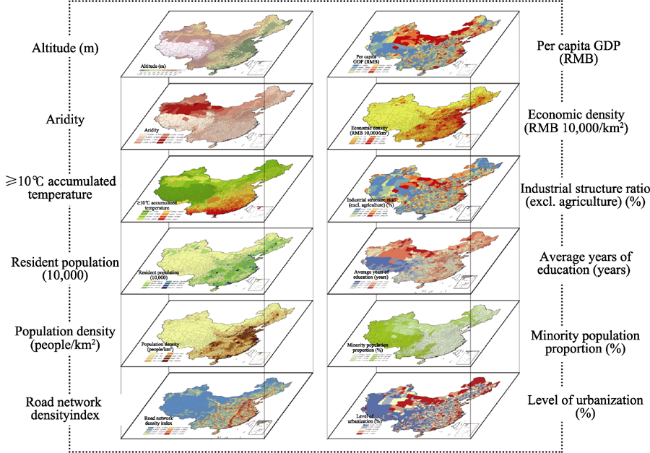
Table 1 Quantitative index system and weight coefficients
Factor classification Layer indicator Layer weight
coefficient
Factor weight coefficient
Natural condition Altitude (m) 0.06 0.17
Aridity 0.07
≥10℃ accumulated temperature 0.04
Population Resident population (10,000) 0.08 0.18
Population density (people/km2) 0.10
Economic indicator Per capita GDP (RMB) 0.11 0.30
Economic density (RMB 10,000/km2) 0.07
Industrial structure ratio (excl. agriculture) (%) 0.12
Cultural factor Average years of education (years) 0.11 0.19
Minority population proportion (%) 0.08
Transport Road network density index 0.08 0.08
Urbanization Level of urbanization (%) 0.08 0.08
Total 1.00 1.00

3.2 Quantitative methods for comprehensive regionalization of Chinese human geography

3.2.1 Factor-weighted overlay method
Due to differences in the basis for the division of regions, different levels of detail and differing qualities of data, as well as differences in zoning methods, the boundaries of zoned sectors are often inconsistent. The zoning in this study, however, uses the same spatial scale for each factor layer, with the division into county-level administrative spatial units achieved using ArcGIS technology (see Figure 1).
Figure 1 Visualization of factor layer overlay for comprehensive regionalization of Chinese human geography
Original data was then normalized, and the entropy weight method and Delphi method were used to calculate the weight of each layer indicator. When the layers were overlaid, altitude and aridity were the first two indicators to obtain negative values. Finally, an initial human geography integrated index was calculated using the integrated index method, and an accurate level of integration of regional attributes was quantitatively assessed. The formula is as follows:
$S=\sum\limits_{i=1}^{n}{{{W}_{i}}*{{S}_{i}}}$ (1)
where Wi is the weighting of the ith layer, Si represents the attribute value of i factors, and S is the human geography integrated index.
3.2.2 Spatial clustering analysis
Spatial clustering is the clustering or classification of entities based on their characteristics and identification of clustered or densely situated areas in large multi-dimensional datasets according to a certain distance or similar measure. Data is then divided into a series of mutually differentiated groups in order to discover the overall spatial distribution laws or typical patterns of the dataset. This study used the Gomory-Hu tree algorithm and Euclidean-based k-means clustering algorithm to carry out spatial clustering of the human geography integrated index.
3.2.3 Experts’ experience and comparative analysis of zoning
In the course of quantitative research, differences in the selection of indicators, the assignment of weightings and clustering algorithms, mean that zoning results differ. As a result, during research on the human geography comprehensive regionalization proposal, having acquired quantitative zoning results, it was necessary to make full use of the experience of experts to make small corrections to computer results to avoid excessive fragmentation and obvious errors. For traditional cultural areas, settlement landscape areas and agricultural areas that have not been quantified, it was also necessary to carry out a comparative analysis with the clustering results in order to optimize the proposal as much as possible.

4 Comprehensive regionalization of Chinese human geography proposal

In accordance with the Chinese human geographic zoning basis, zoning principles and zoning index system, and using the factor-weighted overlay method, spatial clustering algorithm and expert experience, this paper divided China into eight major human geography regions and 66 human geography sub-regions. Here, the naming of the human geographic units is an important link in the comprehensive regionalization of Chinese human geography, as it indicates the hierarchy and characteristics of different integrated zones of human geography. In this study, the comprehensive regionalization of Chinese human geography is divided into two levels: human geography regions (first-level) and human geography sub-regions (second-level). The main factors of first-level regions are economic and natural ecological factors; therefore, they are named according to the type of large economic zones, for example, the Northeast, North, Northwest and South regions. Second-level regions are named after a combination of physical geographic or administrative unit names, such as the Beijing- Tianjin Urban Human Geography Sub-region, Southern Zhejiang Human Geography Sub- region, Hexi Corridor Human Geography Sub-region, and Qinba Mountains Human Geography Sub-region.

4.1 Generating and delineating Chinese human geography regions

In the course of dividing Chinese human geography into regions, the dominant integrated factors considered were natural and economic conditions. After calculating the natural ecological index and integrated economic index at the county level for the whole of China according to the layer weights in Table 1, and using existing physical geographic zoning regions and economic zoning regions as an extra reference, we divided the country into the following eight human geography regions: (I) Northeast China Human Geography Region, (II) North China Human Geography Region, (III) East China Human Geography Region, (IV) Central China Human Geography Region, (V) South China Human Geography Region, (VI) Northwest China Human Geography Region, (VII) Southwest China Human Geography Region, and (VIII) Qinghai and Tibet Human Geography Region. The scopes and basic profiles of the administrative divisions for each human geography region are given in Table 2. The table also contains social and economic development data for each region. The South China Human Geography Region has the highest per capita GDP, industrial structure ratio (excluding agriculture) and level of urbanization. The Central China Human Geography Region has the largest population, but it lags behind in terms of economic and urbanization indicators.
Table 2 Administrative scopes and basic profiles of Chinese human geography regions
Region No. Name of Human Geography Region Administrative divisions
included in scope
Area (10,000 s
km²)
Resident population (10,000s) Per capita GDP (RMB 10,000/
person)
Industrial structure ratio (excl. agriculture) (%) Level of urbanization (%)
Northeast China Heilongjiang, Liaoning, Jilin, eastern Inner Mongolia 142.77 11873.59 6.15 90.23 57.33
North China Beijing, Tianjin, Hebei, Shanxi, northern and central Shandong, central Inner Mongolia 69.75 23476.27 6.48 93.91 52.52
East China Zhejiang, Jiangsu, Anhui,
southern Shandong
37.38 23803.07 7.46 95.16 57.00
Central China Hubei, Jiangxi, Hunan, central and eastern Henan, southern Guizhou, southeast Chongqing 74.98 25757.72 4.08 89.49 42.56
South China Fujian, Guangzhou, Taiwan, Hainan, eastern and western Guangxi, Hong Kong and Macau SARs 71.14 22431.98 9.71 95.76 60.34
Northwest China Shaanxi, Ningxia, Xinjiang, central and northern Gansu, western Inner Mongolia, northeast Qinghai, western Henan 288.25 10120.29 4.30 90.53 44.18
Southwest China Yunnan, eastern Sichuan, southwest and northern Chongqing, western Guizhou 91.39 19762.58 3.40 88.61 40.24
Qinghai and Tibet Tibet, central and western Qinghai, western Sichuan, southern Gansu 256.99 964.19 2.33 84.40 24.65

4.2 Generating and delineating Chinese human geography sub-regions (second-level)

Having divided Chinese human geography into zones, and with overall consideration given to the 10 major elements (nature, economy, population, culture, ethnicity, agriculture, transportation, urbanization, the settlement landscape and administrative divisions), we used weighted overlay analysis to calculate the Chinese human geography comprehensive regionalization index (see Figure 2). It can be seen from the figure that several areas with similar integrated human geography attributes are clustered together and coincide with the divisions into human geography regions. The result of the Moran’s I index was 0.17, below the 1% significance level, with a Z value of 33.59, which indicates significant spatial auto correlation. Given the significant spatial dependence, further spatial clustering analysis was carried out, in which spatial units that are close and have converging attributes were clustered together. Quantitative clustering analysis provided the basis for further dividing second-level Chinese human geography regions. This was combined with top-down qualitative analysis, which took into consideration the fact that second-level human geography regions are subdivisions of human geography regions, on the one hand, while on the other, the need to repeatedly compare the zoning of cultural, agricultural and settlement landscape areas with the boundaries of human geography integrated index clusters. Ultimately, 66 human geography sub-regions were delineated (see Figure 3 and Table 3).
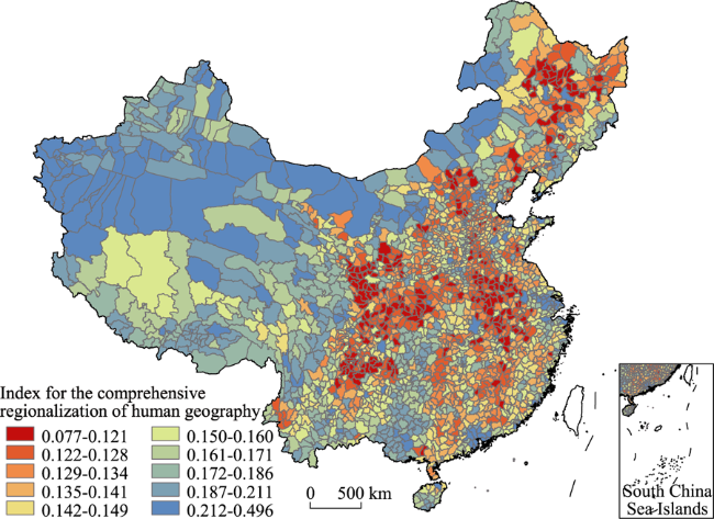
Figure 2 Comprehensive regionalization index results from the weighted overlay of Chinese human geographic factors
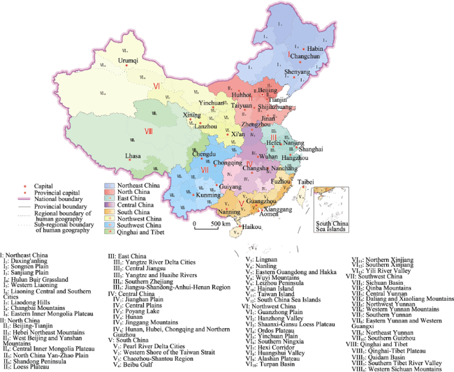
Figure 3 Comprehensive regionalization of Chinese human geography
Table 3 Chinese human geography regions and sub-regions
Name of human
geography region (first-level)
Name of human geography sub-regions (second-level) Number of sub-regions
Northeast China (I) Daxing'anling (I1), Songnen Plain (I2), Sanjiang Plain (I3), Hulun Buir Grassland (I4), Western Liaoning (I5), Liaoning Central and Southern Cities (I6), Liaodong Hills (I7), Changbai Mountains (I8), Eastern Inner Mongolia Plateau (I9) 9
North China (II) Beijing-Tianjin (II1), Hebei Northeast Mountains (II2), West Beijing and Yanshan Mountains (II3), Central Inner Mongolia Plateau (II4), North China Yan-Zhao Plain (II5), Shandong Peninsula (II6), Loess Plateau (II7) 7
East China (III) Yangtze River Delta Cities (III1), Central Jiangsu (III2), Yangtze and Huaihe Rivers (III 3), Southern Zhejiang (III4), Jiangsu-Shandong-Anhui-Henan Region (III5) 5
Central China (IV) Jianghan Plain (IV1), Central Plains (IV2), Poyang Lake (IV3), Hunan (IV4), Jinggang Mountains (IV5), Hunan, Hubei, Chongqing and Northern Guizhou (IV6) 6
South China (V) Pearl River Delta Cities (V1), Western Shore of the Taiwan Strait (V2), Chaozhou-Shantou Region (V3), Beibu Gulf (V4), Lingnan (V5), Nanling (V6), Eastern Guangdong and Hakka (V7), Wuyi Mounatins (V8), Leizhou Peninsula (V9), Hainan Island (V10), Taiwan Island (V11), South China Sea Islands (V12) 12
Northwest China (VI) Guanzhong Plain (VI1), Hanzhong Valley (VI2), Shaanxi-Gansu Loess Plateau (VI3), Ordos Plateau (VI4), Yinchuan Plain (VI5), Southern Ningxia (VI6), Hexi Corridor (VI7), Huangshui Valley (VI8), Alashan Plateau (VI9), Turpan Basin (VI10), Northern Xinjiang (VI11), Southern Xinjiang (VI12), Yili River Valley (VI13) 13
Southwest China (VII) Sichuan Basin (VII1), Qinba Mountains (VII2), Central Yunnan (VII3), Daliang and Xiaoliang Mountains (VII4), Northwest Yunnan (VII5), Western Yunnan Mountains (VII6), Southern Yunnan (VII7), Eastern Yunnan and Western Guangxi (VII8), Northeast Yunnan (VII9), Southern Guizhou (VII10) 10
Qinghai and Tibet (VIII) Qinghai-Tibet Plateau (VIII1), Qaidam Basin (VIII2), Southern Tibet River Valley (VIII3), Western Sichuan Mountains (VIII4) 4
Totals 66 66

4.3 Process and proposal for comprehensive regionalization of Chinese human geography

The process of generating and planning the division of Chinese human geography regions (first- level) and Chinese human geography sub-regions (second-level) was guided by the Chinese human geography comprehensive regionalization proposal made up of eight major human geography regions and 66 human geography sub-regions (see Figure 3). The human geography sub-regions have different topographical, climatic, ecological, population, urbanization, economic development, settlement landscape, regional cultural and ethno-religious attributes. A comparative analysis of human geography regions and sub-regions was omitted due to space limitations. Overall, the comprehensive regionalization of Chinese human geography into regions dovetails closely with Yang Wuyang’s eight economic zones (Yang and Liang, 1992), Ge Quansheng et al.’s nine land surface system zones (Ge et al., 2002), and the 10 first-level Chinese integrated agricultural zones, and it shows that, under the dual roles of nature and humans, there are certain rules of regional differentiation that govern comprehensive regionalization. At the same time, there are many differences. For example, eastern Xilin Gol, Tongliao and the Chifeng region in Inner Mongolia are included in the Northeast China Human Geography Region, due to their economic ties, language and cultural identity being closer to those of northeast China; Xining is included in the Northwest China Human Geography Region, and not in the Qinghai-Tibet Human Geography Region as one might expect based on its physical geographic boundary, primarily due to its close ties with the Lanzhou-Xining urban agglomeration and its development trajectory; and due to the complexity of its terrain, ethnic diversity and varied cultural landscape, the Southwest China Human Geography Region is divided into many relatively small second-level regions.

5 Conclusion and discussion

5.1 Conclusion

The comprehensive regionalization of Chinese human geography is based on the rules of geographical differentiation of Chinese physical geographic factors and takes as its basis 10 human geographic factors (nature, economy, population, culture, ethnicity, agriculture, transportation, urbanization, the settlement landscape and administrative divisions). With full consideration given to the geographical differences and similarities in human factors across China, the country was divided into different spatial levels and relatively independent, complete and organically linked special human geographic units. There are regional differences in human factors between human geographic units, but regional similarities in human factors within units. Compared to previous zoning studies, the comprehensive regionalization of Chinese human geography is more integrated and dynamic. The comprehensive regionalization of human geography highlights the characteristics, regional and sub-regional features, complexity and variety of spatial differences between factors of Chinese human geography. It can promote the development of human geography based on local conditions, and provide basic scientific support to national and local development strategies, such as the Belt and Road, new urbanization and raising environmental awareness, as well as creating a sound geopolitical environment in key areas.
In accordance with the principles of synthesis, dominant factors, the relative consistency of the natural environment, the relative consistency of social and economic development, the consistency of the regional cultural landscape, the continuity of spatial distribution and the integrity of county-level administrative divisions, an index system for the comprehensive regionalization of Chinese human geography was constructed and a combination of top-down and bottom-up zoning and spatial clustering analysis methods was used to divide Chinese human geography into eight regions and 66 sub-regions. The eight regions are (I) Northeast China, (II) North China, (III) East China, (IV) Central China, (V) South China, (VI) Northwest China, (VII) Southwest China, and (VIII) Qinghai and Tibet. Each human geography region and sub-region has different topographical, climatic, ecological, population, urbanization, economic development, settlement landscape, regional cultural and ethno-religious attributes.
This proposal for the comprehensive regionalization of Chinese human geography dovetails closely with previous studies on comprehensive regionalization in Chinese physical geography, Chinese economic zoning, and Chinese agricultural zoning, and it shows that, under the dual roles of nature and humans, there are certain rules of regional differentiation that govern the comprehensive regionalization of Chinese human geography.

5.2 Discussion

5.2.1 The dynamic nature and elasticity of zoning in the comprehensive regionalization of Chinese human geography
Due to the increasing fluidity of population, resources, capital, and information across space and time, unlike physical geographic factors, the geographical distribution of human geographic factors is unstable and changing relatively quickly. The fluidity of such factors and the rootedness of regional cultures are facts that have been known and components that have interacted for a long time, which means the comprehensive regionalization of Chinese human geography must be flexible enough to adapt to change. On the one hand, increasing dynamic adjustments to the temporal dimension improves the quantitative index system and method of zoning, and on the other hand, dynamically adjusting the leading factors or factor weightings of zoning based on practical application requirements, and under an integrated framework with different objectives, expands the applications of this type of zoning. As such, construction of a dynamic monitoring system for Chinese human geographic zoning with space-time bidirectional dimensions and goal-oriented functions, as well as development of dynamic identification and simulation software for comprehensive regionalization of Chinese human geography, are urgent tasks.
5.2.2 Refining the comprehensive regionalization of Chinese human geography and the issue of third-level regions
Having divided Chinese human geography into regions and sub-regions, a question worth looking at is how to divide it into districts (third-level). Difficulties include how to choose the main factors for the division of third-level regions (districts) and which zoning method should be used at the smaller scale. The division of human geography into districts could play an important role in supporting the development of regional urban and rural integration and coordinating with major function-oriented zones at the county level.
5.2.3 The forecasting and guiding functions of comprehensive regionalization of Chinese human geography in regional development and the issue of transcending zoning
In the past, the zoning of single human geographic factors was mostly static and served individual purposes. Comprehensive regionalization of Chinese human geography, on the other hand, focuses on being comprehensive and dynamic. It adopts a systems holism approach in order to provide basic theoretical guidance for the benign evolution of complex socio-economic and ecological systems. As the theory and practice of zoning matures, it will spawn more derivative applications and play more of a guiding role in predicting regional development potential, adjusting the layout of industries, selecting public services and allocating regional materials and resources. Zoning will transcend mere lines on a map to become closely integrated with China’s regional strategy and a way of predicting and guiding the future.

The authors have declared that no competing interests exist.

[1]
Fan Jie, 2015. Draft of major function oriented zoning of China.Acta Geographica Sinica, 70(2): 186-201. (in Chinese)<p>Major Function Oriented Zoning (MFOZ) is the blueprint for the future developmnt and protection pattern of China's territory, and has been raised to from major function zones planning to major function zoning strategy and major function zoning institution. From 2004 to 2014, the author organized a series of research projects to compose MFOZ for the country, studied basic theory of regional function and MFOZ technical process, and proposed that space controlling zones of national and provincial scales can be divided into four types: urbanized zones, foodstuff-security zones, ecological safety zones, cultural and natural heritage zones. On this basis, major function zones of county scale should be transferred to optimized, prioritized, restricted, and prohibited zones. In this paper, a regional function identification index system comprising nine quantitative indicators (including water resources, land resources, ecological importance, ecological fragility, environment capacity, disaster risk, economic development level, population concentration and transport superiority) and one qualitative indicator of strategic choice is developed. Based on the single index evaluation, comprehensive evaluation using regional function suitability evaluation index is conducted, aiming at testing several key parameters including lower limit of protection zones and upper limit of development zones at the provincial level. In addition, a planning-oriented zoning method of major function zones is also discussed, which has brought the first MFOZ planning in China. According to the MFOZ caliber, it is forecasted that national spatial development intensity will rise from 3.48% in 2010 to 3.91% in 2020. Furthermore, according to caliber of the provincial integrated MFOZ planning, the area of optimized, prioritized and restricted zones accounts for 1.48%, 13.60% and 84.92%, respectively, and that of urbanized, foodstuff-security and ecological safety zones accounts for 15.08%, 26.11% and 58.81%, respectively. In combination of analyses of development level, resources and environmental carrying status and quality of the people's livelihood, the main characteristics of MFOZ were identified. Through verification, MFOZ draft of national and provincial scales, which is interactively accomplished with "MFOZ Technical Process" put forward by the author, is mostly above 80% identical with what have been forecasted.</p>

[2]
Fang Chuanglin, Ma Haitao, Wang Jing, 2015. A regional categorization for “New-Type Urbanization” in China.PloS One, 10(8): 1-20.Regional differences in the character of urbanization in China are substantial. The promotion of what has been termed "new-type urbanization" cannot, as a result of these regional differences, be expected to follow a universal approach-rather, such a development must objectively adhere to locational and category-specific principles and adopt differentiated urbanization development models. Regional categorization is often used in geography, but is rarely deployed in research addressing human and social problems relating to urbanization. In March 2014, China published the National New-type Urbanization Plan (2014-2020), which calls for the scientific and reasonable planning of "new-type urbanization," and appropriate regional categorizations are urgently needed in order to guide this reform. Responding to this challenge, this research engaged in the design of a "dominantly quantitative analysis, qualitatively supplemented" method in order to divide China into 5 main regions and 47 sub-regions in terms of new-type urbanization. The paper discusses the features and key problems of each region. This study introduces a new method for regional categorization, thereby remedying the lack of regional categorization in relation to "new-type urbanization" in China, and ultimately promoting the development of regional categorization in the humanities as a valuable reference for healthy and sustainable Chinese urbanization.

DOI PMID

[3]
Fu Bojie, Liu Guohua, Chen Lidinget al., 2001. Scheme of ecological regionalization in China.Acta Ecologica Sinica, 21(1): 1-6. (in Chinese)Ecological regionalization is a base for rational management and sustainable utilization of ecosystems and natural resources It can provide scientific basis for constructing healthy ecological environments and making policies of environmental management In this paper, based on synthetical analysis of the characteristics of ecological environments of China, the principles of ecological regionalization are discussed, and indices and nomenclature of ecological regionalization are proposed, The ecoregions in national scale are divided The results show that there are 3 domains, 13 ecoregions and 57 ecodistricts

[4]
Ge Quansheng, Zhao Mingcha, Zheng Jingyunet al., 2002. Study on division of the terrestrial system in China.Acta Geographica Sinica, 57(5): 515-522. (in Chinese)lt;p>Based on the idea of Top-down and Bottom-up advocated by Huang Bingwei, five integrated divisions in China, including the physio-geographical division, the ecological division, the potential agro-productivity division, the economic division, and the response to global warming of China, are integrated to divide the terrestrial system of China into nine regions at the first level. Then by evaluating the Pressure, State and Response on 46 components for 344 prefectures in China with the PSR Models, the criteria in seven grades for terrestrial system status in every prefecture are established, and terrestrial system status for nine regions are assessed. The results show: (1) The regional differences in landforms and climate are the dominant priority to the regional terrestrial system status. (2) The socio-economic development dominated by human dimension is the secondary priority to the regional terrestrial system status. (3) For terrestrial system status in nine regions, North China, Southeast China and South China are at better level; Northeast China is at middle level; the Southwest China and Shaanxi-Inner Mongolia-Gansu-Shaanxi are at poor level; Northwest China and Qinghai-Xizang are at the worst level.</p>

DOI

[5]
Ge Quansheng, Zhao Mingcha, Zheng Jingyunet al., 2003. Division of the terrestrial system in China: A case study from Huang’s theory on terrestrial system science.Scientia Geographica Sinica, 23(1): 1-6. (in Chinese)In this paper, a brief review are introduced on the development of Terrestrial System Science and the significance for the study on division of the terrestrial system in China, and the objective, principle and methodology for the study on division of the terrestrial system are discussed. Based on the idea of Top-down and Bottom-up advocated by Huang Bingwei, 5 integrated divisions in China, including the Physico-geographical division, the ecological division, the potential agro-productivity division, the economic division, and the response to global warming of China, are integrated to divide the terrestrial system of China into 9 regions at the first level. Then by evaluating the Pressure, State and Response on 46 components for 344 prefectures in China with the PSR Models, the criteria in seven grades for terrestrial system status in every prefecture are established, and terrestrial system status for 9 regions are assessed. The result shows: (1) The regional differences in landforms and climate are the dominant priority to the regional terrestrial system status. (2) The socio-economical development dominated by human dimension is the secondary priority to the regional terrestrial system status. (3) For terrestrial system status in 9 regions, North China, Southeast China and South China are in better level; the Northeast China is in middle level; the Southwest China and Shanxi-Inner Mongolia- Gansu-Shanxi are in poor level; the Northwest China and Qinghai-Xizang are in the worst level.

[6]
Hu Huanyong, 1990. The distribution, regionalization and prospect of China’s population.Acta Geographica Sinica, 45(2): 139-145. (in Chinese)

DOI

[7]
Huang Bingwei, 1959. A preliminary draft of comprehensive physical regionalization in China. Chinese Science Bulletin, 4(18): 594-602. (in Chinese)

[8]
Huang Bingwei, 1998. Comprehensive study of geography and interdisciplinary.Science Monthly, 50(5): 3-5. (in Chinese)

[9]
Liu Junhui, Fu Xiaofeng, 2005. Discussion on method of China’s sustainable development integrated regional planning. China Population Resources and Environment, 15(4): 11-16. (in Chinese)

DOI

[10]
Liu Peilin, Liu Chunla, Deng Yunyuanet al., 2011. Landscape division of traditional settlement and effect elements of landscape gene in China.Acta Geographica Sinica, 65(12): 1496-1506. (in Chinese)The landscape division of traditional settlement is the job with a strong concept with theory and practicality.It is one of the most important topics in studies on cultural landscape division.In views of the characteristics of regional,systematic,stable,development,identical,typical and harmonious traditional settlement landscape in China,setting the inner similarity of traditional settlement landscape "Image" as precondition,and taking opposite consistency principle as main principle while considering other principles,this paper divides the nation's settlement landscape into three large-sized landscape regions,14 landscape regions and 76 landscape subregions.The division,from the practice,are based on the relevant landscape principle,such as the principle of environmental constraints,the principle of cultural guidance,the principle of integrated regions,the principle of relevant identity,the principle of covering and non-continuity,the principle of structures,the principle of comprehensive and landscape identity,etc.Naming principle of landscape area at all levels is area-name plus charecteristic and general name.These large-sized landscape regions,landscape regions and landscape subregions are all different in environmental quality and cultural background,so their integrated settlement and architectural landscapes show strong "identifiability" and "impressionality".The division of China's traditional settlement in this article is from the landscape gene perspective rather than based on cultural characteristics used before.Finally,the paper,in the view of "landscape gene",analyzes the main elements that influence the judges of China's traditional settlement landscape genes,from the elements of psychology,ecology,aesthetics,environment,culture,time and order and so on.

DOI

[11]
Liu Yanhua, Zheng Du, Ge Quanshenget al., 2005. Problems on the research of comprehensive regionalization in China.Geographical Research, 24(3): 321-329. (in Chinese)The modern regionalization in China has attained plentiful and substantial achievements in recent 50 years and has made important contributions to the socio-economic construction. Meanwhile, great changes have taken place in the natural and socio-economic patterns in China. So it is indispensiable to develop comprehensive regionalization as the basis of the sustainable socio-economic development for China. The main scientific issues to be discussed are as follows: 1) the target of service and the mission of research; 2) the theory and system of comprehensive regionalization; 3) the changing processes, patterns and their interactions of the main elements in regional system; 4) the identification of the boundaries between the regional systems in China; 5) the identification of typical regions and the analysis on their characteristics; 6) the interaction between the global geographical patterns and the comprehensive regional system in China; 7) data mining, processing and dimensioning; 8) the integrative methodology of comprehensive regionalization; 9) scenario analysis for the future evolution of regional system in China; and 10) the dynamic demonstration system for the comprehensive regionalization.

DOI

[12]
Martin G J, 2005. All Possible Worlds: A History of Geographical Ideas. London: OUP Catalogue.Updated and revised to include theoretical and other developments, bibliographical additions, new photographs and illustrations, and expanded name and subject indexes, the fourth edition of All Possible Worlds: A History of Geographical Ideas is the most complete and comprehensive book of its kind. The text also features a layout and readability that make the material easy to navigate and understand. The book investigates the ways in which the subject of geography has been recognized, perceived, and evaluated, from its early acknowledgment in ancient Greece to its disciplined form in today's world of shared ideas and mass communication. Strong continuities knit the Classical Period to the Age of Exploration, then carry students on through Varenius to Humboldt and Ritter--revealing the emergence of "the new geography" of the Modern Period. The history of American geography--developed in seven of the twenty chapters--is strongly emphasized pursuant to the formal origins of geography in late nineteenth-century Germany, Darwin's theory of evolution, and the great surveys of the American west. This treatment is enhanced by chapters concerning parallel histories of geography in Germany, France, Great Britain, Russia (including the USSR and CIS), Canada, Sweden, and Japan-countries that at first contributed to and later borrowed from the body of US geographical thought. All Possible Worlds: A History of Geographical Ideas, Fourth Edition, is ideal for upper-level undergraduate or graduate courses in the history and philosophy of classical, medieval, and modern geographical thought.

DOI

[13]
Ren Mei’e, Yang Renzhang, 1961. Physical regionalization in China.Acta Geographica Sinica, 27(12): 66-74. (in Chinese)

DOI

[14]
Song Changqing, 2016. On paradigms of geographical research.Progress in Geography, 35(1): 1-3. (in Chinese)

DOI

[15]
Wu Bihu, 1996. Partition and the formation of the Chinese culture areas.Academic Monthly, (3): 10-15. (in Chinese)

[16]
Wu Shaohong, Liu Weidong, 2005. An integrated approach to classification of territorial systems: A case study of the Tibetan Plateau.Geographical Research, 24(2): 169-177, 321. (in Chinese)Recent geo-researches display two significant features. First, most research projects are centered on revealing the implications for regional sustainable development and ecological security; and second, these projects try to employ an integrated approach to taking both physical and socio-economic factors into consideration. Indeed, the implementation of sustainable development strategy demands a classification of territorial systems based on such an integrated approach. To be integrated, a key scientific issue is how to synthesize the physical and socio-economic factors in the process of classification. Based on a new indicator system, which involves mainly physical indicators at the macro level and socio-economic indicators at micro level while employing both at the middle level, this paper tries to develop a new integrated approach to the classification of territorial systems to reveal the features of human-nature relationship at various spatial levels. The new system of classification is a hierarchy consisting of five levels: class zero realm; class one ecological zone (and/or) sub-zone; class two land-human region; class three eco-economic division; and class four economic districts. The classification at the first three levels is a "top-down" process; that at the fifth level is a "bottom-up" process; and that at the fourth level is a matching process from both the top and the bottom. The paper further tests the new approach of classification via a case study of the Tibetan Plateau. By the approach, the Plateau is divided into 3 zones, 15 regions, 22 divisions and 29 districts. Such classification results have profound implications for regional sustainable development.

DOI

[17]
Wu Shaohong, Yin Yunhe, Fan jieet al., 2010. Retrospect and prospect of regionalization system of China.Geographical Research, 29(9): 1538-1545. (in Chinese)Regionalization system of China has attained substantial achievements in the last decades by the Institute of Geographic Sciences and Natural Resources Research under the Chinese Academy of Sciences.Based on the stages of "integrated physical geographical regionalization-eco-geographical regionalization-comprehensive regionalization",significant progresses and achievements of some important regionalization schemes were introduced in this paper.In 1950s,integrated physical geographical regionalization was initiated in order to guide the distribution of agricultural production.In the 1990s,eco-geographical regionalization was carried out to instruct ecological development and environmental protection based on ecological theories and methods.Since the end of the 20th century,comprehensive regionalization has been developed along with the further research into earth science and sustainable development.A combination of physical factors with socio-economic factors has been the distinguishing characteristic of recent regionalization research.Moreover,the continuous innovation in methodology and technology,such as remote sensing,geographical information system and numerical simulation,has promoted the development of regionalization research.Regionalization system which was tightly coupled with national economic development and environmental protection would be an important direction of physical geography and even geography in future development.

DOI

[18]
Yang Qinye, Zheng Du, Wu Shaohonget al., 2005. Review and prospects: Integrated physical geography in China since the 1950s.Geographical Research, 24(6): 899-910. (in Chinese)Integrated Physical Geography(IPG) is an important subdiscipline of physical geography,i.e.narrow-sensed Physical Geography.The IPG studies physiographical environment the whole terrene which is the habitation of human beings comprehensively and systmetically.It emphasizes the matter-energy relationship among factors of physiographical environment,interprets the historical formation,modern process,type structure,terrain differentiation and evolution of physiographical environment.Integrated study includes correlative and complementary aspects: modern process and historical process.The modern process integrated study of the physiographical environment involves the distribution,transformation of heat and water on land surface,as well as its function in physiographical environment.It also involves chemical elements migration in the physiographical environment,the matter-energy exchange between the biological community and the environment.Landscape science and land science study natural complex from type structure point view comprehensively,while physical geographical regionalization makes the integrated study at regional angle differently.The physiographical environment is the product of the history.Paleogeographical environment,especially the historical study about the paleogeographical environment-forming process since the Neogene,is a subdiscipline of the IPG,just the content of paleogeography.In China,the IPG with Chinese characteristics has been formed and developed since the 1950s.Chinese IPG integrated study has made so much remarkable progress in paleogeography:integrated physical geographical regionalization,landscape science,land science,modern physical geography processes,regional physical geography,integrated research of physical geography,etc.This paper will make a generalization and retrospection about the achievement from the aspects above.

DOI

[19]
Yang Wuyang, Liang Jinshe, 1992. China’s ten economic zones.Economic Geography, 12(3): 14-20. (in Chinese)

[20]
Zhao Songqiao, 1983. A new scheme of comprehensive physical regionalization in China.Acta Geographica Sinica, 38(1): 1-10. (in Chinese)

[21]
Zheng Du, 2012. Dictionary of Geographical Regionalization and Planning. Beijing: China Waterpower Press. (in Chinese)

[22]
Zheng Du, Fu Xiaofeng, 1999. A preliminary study on issues of integrated geographical regionalization.Scientia Geographica Sinica, 19(3): 193-197. (in Chinese)Regional study is an ancient and important tradition, forming the regional school of geography. In view of integrated or unified geography, regional study of sustainable development is an important level for approaching regional system of man land relationship and effective way for coordinating man nature relationship. Aimed at sustainable development the integrated geographical regionalization includes natural elements and human factors. Main principles for demarcation are as follows: combining regional differentiation of physical environments and human geography, integrating comprehensive analysis and principal factors, genetic unity, as well as linking regional frameworks with regional types, etc. Criterion and index system of the integrated geographical regionalization consists of environments, resources, economy, society and population, etc. The selected criteria and indices for demarcation should be practical, simplified, comparable, quantified, and reflecting dynamic state and trends of various regions. Regional types of development states may be identified based on the above mentioned results, then proposing a tentative scheme of the integrated geographical regionalization.

[23]
Zheng Du, Ge Quansheng, Zhang Xueqinet al., 2005. Regionalization in China: Retrospect and prospect.Geographical Research, 24(3): 330-344. (in Chinese)Based upon a review on foreign regionalization work, this paper summarized the characteristics of the regionalization work in different stages, gave a brief introduction to the methodology in the regionalization of China, and discussed some issues on the regionalization work. Since the latter half of the 20th century, the regionalization in China has entered a stage of systematic research and all-around development. The main characteristics of the regionalization work in this stage are as follows. First, the various regionalization schemes are based on their historical background respectively. They are the scientific work closely related to the economic development and social demands at the time. Roughly speaking, research on the regionalization in China had mainly served agricultural production since the 1950s. Since the 1980s, the research had been concentrated on economic development. Since the 1990s, the regionalization work has been focused on sustainable development. Second, the work was mostly static and was not able to reflect the dynamics of the changing natural and social factors. And several important boundaries were identified with some assumption and presumption. In recent years, some trends of overemphasizing models and quantification have appeared in regionalization studies. Third, the regionalization studies were inclined to physical geography. The economic geographical regionalization studies were relatively weak. Moreover, current physical and economic regionalization studies are not well related, which has become a limitation to the research of regional sustainable development. Fourth, current regionalization studies focus on terrestrial system, and haven't paid enough attention to marine system. Fifth, the confirmation of regionalization schemes is not institutionally assured yet. So the research results have not been well absorbed by the economic planning of local governments, and the purpose of serving the sustainable socio-economic development has not been realized. Finally, the necessity and importance of carrying out comprehensive regionalization in China was analyzed, and some key scientific issues related with the comprehensive regionalization of China were discussed. The paper pointed out that as a new growing point of regionalization researches, comprehensive regionalization with an integration of natural and social factors will be an important contribution of the human-earthsystem research to the sustainable development.

DOI

[24]
Zheng Jingyun, Bian Juanjuan, Ge Quanshenget al., 2013. The climate regionalization in China for 1981-2010.Chinese Science Bulletin, 58(30): 3088-3099. (in Chinese)lt;p>The scheme of climate regionalization in China was conducted by the classification criteria of temperature zone, arid/humid region and climatic sub-region, and the variables used in the criteria were calculated as mean values of the 30 years by using the daily meteorological data of 658 stations from 1981 to 2010. In the classification criteria, the temperature zones were classified by the general guideline of the days with daily temperature steady above 10℃, and the secondary guideline of January mean temperature, or by their referenced variables including the accumulated temperature with daily temperature steady above 10℃ and annual minimum temperature, respectively. The arid/humid regions were classified by the annual aridity index and annual precipitation amount in turn. The climatic sub-regions were classified by the July mean temperature. The result shows that China can be divided into 12 temperature zones, 24 arid/humid regions and 56 climatic sub-regions. Compared with the climate regionalization scheme for the period of 1951- 1980, several boundaries of temperature zones in eastern China shifted northward in 1981-2010 due to the climate warming. The east part of the northern boundary of warm temperate zone shifted more than 1.0&deg; at a maximum. On average, the east part of the northern boundary of north subtropical zone shifted 1.0&deg;. The middle part of the northern boundary of mid-subtropical zone shifted 2.0&deg; at a maximum. The west part of the northern boundary of south subtropical zone shifted 0.5&deg;-2.0&deg;. In West China, the shift of temperature zone was not significant in horizontal due to the vertical landform. However, the plateau sub-cold zone was shrunk while the plateau temperate zone was enlarged in the Tibetan Plateau. Because precipitation decreased in North China, southeastern part of Northeast China and eastern part of Northwest China, the boundary of the semi-arid and sub-humid region in Northern China shifted eastward and southward, and in which, the boundary between 36&deg;-41&deg;N shifted 0.5&deg;-2.5&deg;at longitude. Moreover, the climate in the most of arid regions and semi-arid regions in Hexi Corridor, Xinjiang and the Tibetan Plateau changed to be more humid.</p>

DOI

Outlines

/