Review Article

Global understanding of farmland abandonment: A review and prospects

  • LI Shengfa , 1, 2 ,
  • LI Xiubin , 1, *
Expand
  • 1. Key Laboratory of Land Surface Pattern and Simulation, Institute of Geographic Sciences and Natural Resources Research, CAS, Beijing 100101, China
  • 2. University of Chinese Academy of Sciences, Beijing 100049, China

*Corresponding author: Li Xiubin, Professor, E-mail:

Author: Li Shengfa, PhD Candidate, specialized in land use change analysis. E-mail:

Received date: 2016-10-24

  Accepted date: 2017-01-20

  Online published: 2017-09-05

Supported by

The NSFC-IIASA Major International Joint Research Project, No.41161140352

Copyright

Journal of Geographical Sciences, All Rights Reserved

Abstract

Since the 1950s, noteworthy farmland abandonment has been occurring in many developed countries and some developing countries. This global land use phenomenon has fundamentally altered extensive rural landscapes. A review of global farmland abandonment under the headings of “land use change - driving mechanisms - impacts and consequences - policy responses” found the following: (1) Farmland abandonment has occurred primarily in developed countries in Europe and North America, but the extent of abandonment has varied significantly. (2) Changing socio-economic factors were the primary driving forces for the farmland abandonment. And land marginalization was the fundamental cause, which was due to the drastic increase of farming opportunity cost, while the direct factor for abandonment was the shrink of agricultural labor forces. (3) Whether to abandon, to what extent and its spatial distributions were finally dependent on integrated effect from the physical conditions, laborer attributes, farming and regional socio-economic conditions at the village, household and parcel scales. With the exception of Eastern Europe, farmland abandonment was more likely to occur in mountainous and hilly areas, due to their unfavorable farming conditions. (4) A study of farmland abandonment should focus on its ecological and environmental effects, while which is more positive or more negative are still in dispute. (5) Increasing agricultural subsidies will be conductive to slowing the rate of farmland abandonment, but this is not the only measure that needs to be implemented.

Due to China’s rapid urbanization, there is a high probability that the rate of abandonment will increase in the near future. However, very little research has focused on this rapid land-use trend in China, and, as a result, there is an inadequate understanding of the dynamic mechanisms and consequences of this phenomenon. This paper concludes by suggesting some future directions for further research in China. These directions include monitoring regional and national abandonment dynamics, analyzing trends, assessing the risks and socio-economic effects of farmland abandonment, and informing policy making.

Cite this article

LI Shengfa , LI Xiubin . Global understanding of farmland abandonment: A review and prospects[J]. Journal of Geographical Sciences, 2017 , 27(9) : 1123 -1150 . DOI: 10.1007/s11442-017-1426-0

1 Introduction

An area’s land use usually corresponds to its concomitant stages of social development. Consequently, land use transitions in lockstep with the stages of development (Long et al., 2002). During preindustrial and early industrialization periods, growing populations and economies led to increasing demands for food and wood. As a result, larger land areas were cultivated and developed, and the extent of forest cover declined. This stage was called, “national land use transition” by Grainger (1995). When the speed of urbanization and industrialization increases, however, the rate of net deforestation in the whole country slows down and stops, after which net deforestation gives way to net reforestation. This land-use transition process was named “forest transition” by British geographer Mather (1992). Over the last 20 years or so, the “forest transition” phenomenon has been very apparent in developed countries and regions such as Europe, the United States, and Japan, and it has been confirmed in developing countries that include China, Vietnam, India, and the Philippines (Rudel et al., 2005). Generally speaking, in developed countries forest transition is achieved by means of an “economic growth pathway,” while the forest transition in developing countries occurs by following a “forest scarcity pathway” (Rudel et al., 2005; Lambin et al., 2010). Economic growth pathways describe economic development that creates enough non-farm jobs that farmers choose to leave their farms, thereby abandoning poor farmland and contributing to reforestation (Rudel et al., 2005). The forest scarcity pathway describes an increased demand for forest products or forest ecosystem services that drives afforestation on marginal farmlands. During the forest transition process, the expanding ecological land represented by forests is combined with the shrinking farmland (Barbier et al., 2010). On the economic growth pathway, farmland abandonment is the main reason for the shrinking farmland, and natural reforestation on abandoned land is the main reason for forest expansion.
The marginalization of farmland refers to the decline of farmland profits or rentals for certain types of land use. Agricultural abandonment is an extreme outcome of marginalization. The rural exodus induced by urbanization and industrialization normally leads to the marginalization of farmland (Li et al., 2011a), and then to the large-scale abandonment of marginal farmland. In developed countries, abandonment of farmland is already a major trend in agricultural land-use change (MacDonald et al., 2000). Many studies have shown that China experienced a forest transition in the 1980s, and suggest that China’s forest transition is on the forest scarcity path (Li et al., 2011a). However, China’s forest transition will likely shift from a forest scarcity pathway driven by policy, to an economic growth pathway. The reason for this is that as a result of China’s rapid on-going industrialization and urbanization, larger numbers of rural laborers are moving to urban areas for manufacturing and service jobs, thereby greatly reducing the size of agricultural labor forces in rural areas, and contributing to farmland marginalization. The China Family Financial Survey and Research Center under the Southwestern University of Finance and Economics carried out two national household surveys of 262 counties in 29 provinces in 2011 and 2013. The results indicate that in 2011 and 2013, 13.5% and 15% of agricultural land, respectively, were idle (Gan et al., 2015). As rapid industrialization and urbanization continue, rural labor forces will decline further, and the labor-intensive practices used for sloping lands will be further marginalized (Li et al., 2011a), further exacerbating farmland abandonment. Drafting informed policies to mitigate farmland abandonment depends on a better understanding of the complex interactions that lead to undesirable outcomes.
Farmland abandonment and the subsequent restoration of vegetation have significantly changed rural land use patterns, the agricultural landscape, and farmers’ livelihoods. These practices have also had striking ecological and socioeconomic effects (Pointereau et al., 2008), especially in terms of reversing the long-term declines of forest areas induced by economic growth (Cramer et al., 2008). Hence, farmland abandonment has attracted increasing attention (Queiroz et al., 2014), and become an important component of LUCC research. Many studies have been conducted on the drivers and mechanisms of farmland abandonment, the spatial distribution of abandoned land, the factors that influenced these changes, the resulting ecological and social effects, and related policy designs. Most of these studies focused on developed countries, and especially on Europe, where land abandonment is widespread (Benayas et al., 2007; Queiroz et al., 2014). Nonetheless, research on global farmland abandonment still lacks a comprehensive review. Consequently, this paper systematically reviews existing across-the-board achievements related to global farmland abandonment. These include documenting the distribution of farmland abandonment, its causes and drivers, influencing factors, social and environmental effects, and the policies that have been drafted and applied, under the LUCC research general framework of “land use change - driving mechanisms - impacts and consequences - policy responses”. We then provide some advice for the study of farmland abandonment in China, with the objective of promoting sustainable land use in mountainous areas.
Farmland, as used in abandonment research, describes agricultural land that usually includes cropland (sometimes called cultivated land or arable land) and meadows, especially in the European region. Farmland abandonment describes the cessation of using and managing agricultural land (Weissteiner et al., 2014), and the degradation of farmland facilities to the extent that they cannot easily be used again (FAO, 2006a), together with the natural restoration of vegetation (Díaz et al., 2011). This paper takes a broad view in order to achieve a full understanding of land abandonment.

2 Farmland abandonment has mainly occurred in developed regions

Although farmland abandonment became a global trend during the past half century, the “actual abandoned farmland” is difficult to define, identify, and estimate, because it is characterized by gradual change, complexity, variety, and a scattered distribution (Keenleyside et al., 2010). It is also more difficult to extract land use information on abandoned land using remote sensing than it is to gather land-use change information on other land. Mapping abandoned farmland with time-series vegetation indices using multi-temporal remote sensing data is a more effective approach (Alcantara et al., 2012). Alcantara et al. (2013) used time-series MODIS satellite imagery to map abandoned agricultural lands in Central and Eastern Europe; their results showed that 1/5 of the farmland in this region (52.5 million ha) had been abandoned by 2005. Due to the large number of mixed pixels of the remote sensing imagery, the accuracy of classifications of large regions is not high (user’s accuracy is 40% to 75%), and it is lower in hilly and mountainous areas (Estel et al., 2015). There is still no accurate value for global abandoned farmland, nor are there official statistics, except for Japan. Its national land abandonment survey shows that the total abandonment rate was 10.6% in 2010 (MAFF, 2011). According to existing knowledge, farmland abandonment has predominantly occurred in developed countries in Europe, in the United States, Australia, and Japan (Meyfroidt et al., 2011; Queiroz et al., 2014). In addition, it has been reported that mountainous areas of China (Li et al., 2011a; Shao et al., 2015), Latin America (Aide et al., 2004), and Southeast Asia (Shively et al., 2001; Lambin et al., 2010) have also experienced this phenomenon. The distribution of abandoned farmland is not uniform across these countries. For example, abandoned farmland in the United States was concentrated in the east (Brown et al., 2005; Ramankutty et al., 2010). In Europe, Central Europe, the Mediterranean, and Eastern Europe have the highest abandonment rates (MacDonald et al., 2000; Hatna et al., 2011; Weissteiner et al., 2011; Alcantara et al., 2013). According to a historical reconstruction of arable land data, the abandoned area of farmland globally was estimated at 2.35 million km2 from 1700 to 1990, and most of the farms were abandoned between 1900 and 1990 (Ramankutty et al., 1999). Another study of historical arable land data from HYDE 3.0 and SAGE indicated that the total area of abandoned farmland in the 20th century was 385 million to 472 million km2 (Campbell et al., 2008), and accounted for 8% to 10% of the world’s cultivated area in 2012.
To better understand the global distribution and evolution of farmland abandonment, we used long-term agricultural data from the Food and Agriculture Organization (FAO) to develop a rough estimate. Figure 1 shows that areas used for agriculture in developing regions such as Asia, Africa, and Latin America were increasing from 1961 to 2011, whereas areas used for agriculture in Western Europe, Southern Europe, North America, and Oceania were steadily decreasing, and had a total reduction in agricultural area of 3.79 million km2. Meanwhile, the forest cover in these regions has increased over the past 50 years (Gold et al., 2006). Generally, forest transition in developed regions is driven by economic growth (Rudel et al., 2005; Barbier et al., 2010), thus the reduction in agricultural area since 1960 illustrates the farmland abandonment in these high-income areas. Developed countries in Asia, such as Japan and South Korea, have also experienced similar reductions in agricultural areas since the 1960s. Contrary to the steady increase in farmland abandonment in developed countries, the number of agricultural areas in Eastern Europe decreased sharply during the early 1990s, because of the collapse of the Soviet Union (Baumann et al., 2011). This change implies that the driving force of abandonment in Eastern Europe is different from other regions.
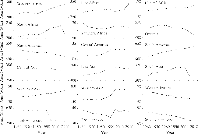
Figure 1 Farmland area changes on all continents from 1961 to 2011(Data source: FAO.)

3 Drivers and causes of farmland abandonment

3.1 Socioeconomic factors are the primary drivers of farmland abandonment

Research has confirmed that macro-level socioeconomic factors are the driving force behind farmland abandonment (Benayas et al., 2007). We summarized these factors as follows (see more examples in Table 1): (1) the out-migrations of rural populations and substantial reductions to the agricultural labor force due to urbanization and industrialization; (2) declining agricultural profits due to changing market demands, foreign trade developments, and the rising prices of agricultural products; (3) new agricultural policies; (4) land system reforms; and (5) new agricultural technologies and agricultural commercialization.
Urbanization and industrialization have been widely considered as the fundamental drivers of farmland abandonment in many areas, and especially in developed countries and regions such as Europe and Japan (MacDonald et al., 2000; Kozak, 2003; Romero-Calcerrada et al., 2004). The rapid development of secondary and tertiary industries has created a large number of non-agricultural jobs with higher incomes and shorter working hours. These jobs serve to widen the gap between urban and rural incomes and quality of life, and eventually lead to large rural-urban migrations. With a declining rural population and a smaller agricultural labor force, poor farmland with low output has been abandoned (Rudel et al., 2005; Strijker, 2005; Benayas et al., 2007). Decreasing demand (Doorn et al., 2007), rising agricultural prices (Rudel et al., 1996), and the development of foreign trade (Aide et al., 2004; van Meijl et al., 2006) have led to lower prices and/or higher costs for agricultural products, thereby reducing profits from farmlands, impelling farmers to move away from their farms in search of economic alternatives in non-agricultural sectors, and eventually abandoning their farmland. Agricultural subsidies increase incomes from farmland use, so policies promoting subsidies could slow farmland abandonment to some extent (Díaz et al., 2011). In the EU, the Common Agricultural Policy (CAP) and the fallow land subsidy policy have significantly influenced the abandonment of marginal land in Europe (Strijker, 2005; Estel et al., 2015).
The driving force for farmland abandonment in Eastern Europe is different from that in Western Europe and Southern Europe. In Eastern Europe, land system reform is the driver.
Table 1 Typical drivers of farmland abandonment in main research areas
Study region Terrain Drivers and causes Study period References
Northeastern Spain Mountain Depopulation, livelihood changed 1984-2007 Melendez-Pastor et al., 2014
Southeast of Portugal Hilly Implementation of EU common agricultural policy, rural exodus, marginalization of
farmland
1985-2000 Doorn et al., 1996
The Pyrenees Mountain Changes in demand, marginalization of
farmland
1950-2000 Mottet et al., 2006
Central and
southern France
Mountain Depopulation 1975-1998 Andre, 1998
Mountain Swiss Mountain Rural depopulation, increase of part-time households 1980s-1990 Gellrich et al., 2007a
Western Russia Plain Social and economic reform, subsidies stopped 1984-2010 Prishchepov et al., 2013
East of Albania Mountain Massive imports of low-cost agricultural products led to a decline in incomes for local agricultural production, which made many farmers move out and seek employment in a non-farm sector 1988-2003 Sikor et al., 2009
Southern Russia Plain Collapse of the Soviet Union, the central government stopped providing agricultural subsidies 1989-1998 Hölzel et al., 2002
Carpathians Mountain Social and economic reform, land system reform 1986-2000 Kuemmerle
et al., 2008
Central Latvia Hilly Lack of agricultural laborers, privatization of land ownership Since 1990 Nikodemus
et al., 2005
Slovakia Mountain Market economy; an increase of imports led to a decline in both the demand for and price of local agricultural products, which led to marginalization of farmland; other causes included the lack of young laborers, an aging labor force, and a diversity of livelihoods 1990-2010 Lieskovský
et al., 2015
Western Ukraine Mountain Collapse of the political system, an incomplete land system reform, and more opportunities for non-farm jobs 1989-2008 Baumann
et al., 2011; Alix-Garcia
et al., 2012
Southern Poland Mountain The mobility of the local population and increases in off-farm employment 1823-2001 Kozak, 2003
South Appalachian Mountain & Hilly Marginalization of farmland: low productive farmland that needed more input of fertilizers, and entailed higher farm costs 1935-1975 Rudel et al., 1996
Northern Thailand Mountain Land degradation, new forestry policy, economic reform, liberalization of the rice market Since 1990s Lambin et al., 2010; Tachibana
et al., 2001
Latin America Mountain Rapid development of secondary and tertiary industries, rural-urban migration, shrinking numbers of agricultural laborers, large-scale commercial production in agriculture in plain areas, foreign trade development Since 1980s Aide et al., 2004
Puerto Rico Mountain Industrialization in the coastal region and aviation industrial development led large numbers of agricultural laborers to migrate to non-agricultural sectors in coastal areas and North America 1950-1990 Rudel et al., 2000
Acud Island in Chile Hilly Urbanization and industrialization 1985-2007 Díaz et al., 2011
Western Japan Mountain Out-migration of young labor forces, depopulation 1950s-1990s Kamada
et al., 1997
Southern Palawan, the Philippines Mountain Irrigation technology development increased the multiple cropping index in the coastal plain area, which provided higher incomes, and led to an increase in the cost of agricultural opportunities for mountain farmers 1990s Shively et al.,
2001
South of the Himalayas, Nepal Mountain Improved transportation; more off-farm job opportunities promoted the out-migration of the rural population and resulted in a shortage of agricultural laborers; an increase in the proportion of off-farm income reduced farmers’ dependence on land
Low incomes from marginal land, the decline of soil fertility, and land reform
1970s-2000 Khanal et al., 2006
Dadu River, Sichuan, China Mountain Land system reform, more farmers seeking employment in urban areas, marginalization of farmland 1967-2000 Yan et al., 2005
Southern Ningxia province, China Mountain Increase in farming opportunity costs, out-migration of agricultural laborers, marginalization of farmland ~2008 Tian et al., 2009
Chongqing, China Mountain Increase in farming opportunity costs, out-migration of agricultural laborers ~2010/2012 Zhang et al., 2011a; Shao et al., 2015; Yan et al., 2016a
Jiangxi province, China - Rising opportunity cost of agricultural production, out-migration of agricultural laborers 1990-2005 Xie et al., 2014
Bijie in Guizhou province, China Mountain Low income for agricultural production, poor farm conditions, lack of laborers ~2012 Ge et al., 2012
After the collapse of the Soviet Union in 1991, the public land ownership system was transformed into a private system, in which farmlands were obtained by people without farm management experience and/or without any interest in farm management. This not only resulted in weak links between farm ownership and management, but also increased transaction costs due to the fragmentation of farm ownership. The reduction or even cancellation of agricultural subsidies and the lack of agricultural technical services in an incredibly competitive market also contributed to the agricultural recession and high rural unemployment rates in Eastern Europe. With the impetus of urbanization and industrialization, growing numbers of rural laborers—and especially young laborers—moved to the cities. This migration eventually led to widespread abandonment of agricultural land (DGL, 2005; Baumann et al., 2011). Among Eastern European nations, Russia suffered its most severe agricultural abandonment since the collapse of the Soviet Union (Alcantara et al., 2013).
The land management system has been considered one of the important causes for farmland abandonment in China. In the context of China’s imperfect rural social security system, although farmland’s function of providing subsistence for the aged is weakening, farmers have a “land complex” that inclines them toward retaining a landholding, even though they will not farm their land again (Cao et al., 2008). In some areas grain subsidies are disconnected from grain production, which is to say that some farmers receive subsidies for farmland that is not used for grain production, and this practice actually reduces farmers’ economic incentive to farm or rent out their land (Jin, 2013), and increases the probability of farmland abandonment. Moreover, the stability of land contract management rights has increased the transaction costs and restricted the emergence of a land rental market (Deininger et al., 2009). Therefore, enhancing the marketization of agricultural tenancy could prevent high-quality arable land from being abandoned (Zhang et al., 2014a, 2014b). Still, we cannot ignore that the imperfections of the imperfect land rental system also hinder the transfer of rural labor forces, so combined with an increase in the number of part-time farmers, it could slow the pace at which farmland is being abandoned (Min, 2010).
The development of agricultural technology first improved grain yields, which then led to a reduced demand for arable land, which, in turn, may lead to farmland abandonment. Rudel et al. (2001) found that from 1953 to 1975, counties in the southern United States with the largest increases in crop yields per acre showed greater gains in forest cover, whereas counties that had lower increases in yields per acre showed declines in forest cover and increases in the acreages planted. Mather and Needle’s farmland allocation model showed that, even without technological advances, farmers could learn to farm the fertile land intensively, and abandon marginally productive land (Mather et al., 1998). In fact, the intensive use of cultivated land is an agricultural development trend (Foley et al., 2005), and increasing land use intensity produces higher grain yields. In the context of growing global grain demands, advances in agricultural technology contribute to the shrink of cultivated area and the subsequent abandonment of former farmland.
In addition to socioeconomic factors, inappropriate agricultural practices can lead to severe soil erosion and land degradation, thereby contributing to the abandonment of agricultural land (Benayas et al., 2007), though the area impacted by land degradation is usually localized. In addition, climate change may also increase or decrease the risk of land abandonment (EC, 2009; Keenleyside et al., 2010).

3.2 Farmland marginalization is the fundamental cause of farmland abandonment

Neoclassical economics argues that land resources tend to be used in the most profitable way in a market economy (Barlowe, 1989), so land-use changes result from changes in the possibilities for various uses and from comparative benefits (Li, 2002). When only one land-use type is feasible, if the profit from farmland use is reduced to zero or is even negative (not viable for farming) due to price changes for inputs and outputs, that is, farmland is beyond the margin of zero rent, and no matter how the farmer adjusts the input proportions the farmland always exceeds this margin, then rational farmers have no motivation to farm the land, so the land will be abandoned (MacDonald et al., 2000). The processes of urbanization and industrialization create very large numbers of non-agricultural employment opportunities, which pull rural people off the farms and lead them to migrate to urban areas (Li et al., 2011a; Liu et al., 2005). Next, the relatively larger incomes and opportunities associated with non-farm jobs’ increase the opportunity costs of agricultural production, and lead to a rapid rise in the cost of agricultural labor. The increasing cost of farming, coupled with reductions in the profits of agricultural production, eventually generates marginalization and leads to the abandonment of poor cultivated land (Strijker, 2005; Xie et al., 2014). Large-scale farmland abandonment is a response to the process of urbanization and industrialization in developed countries, mainly due to the marginalization of farmland that has occurred as a result of the rising opportunity cost of farming. Fundamentally, the drivers of farmland abandonment—including changing demands (Lieskovský et al., 2015), the development of international trade (Hecht et al., 2007), rising agricultural prices (Rudel et al., 1996), cuts to agricultural subsidies (Prishchepov et al., 2013), advances in agricultural technologies (Shively et al., 2001), and policies that promote ecological conservation (Ding et al., 2009)—all resulted in rents decreasing and farmland marginalization. We can conclude that marginalization is a necessary cause for farmland abandonment, however, in the process of becoming marginalized, if the rent for another feasible type of land use (such as forest land) increases, this type of land use will be undertaken, and the land will not necessarily be abandoned (Liu et al., 2005). For example, farmers in southern China are more likely to plant eucalyptus, walnut, or fruit trees on marginal land, than to abandon it.
Some studies allege that China reached Lewis’ turning point in 2003 (Zhang et al., 2011b). Although this allegation is still being debated, we note that the wages for labor in China have shown a dramatic upward trend. Since 2003, the wages for China’s migrant workers have risen at an annual rate of about 10% (Fang et al., 2009; Lu, 2012). This has led to a rapid increase in the labor costs for agricultural production (Figure 2). From 2003 to 2013, the labor costs for agricultural laborers rose by 6.1 times, while the prices of seeds, fertilizers, pesticides, agricultural films and products increased by 2.9, 2.5, 2.9, 1.8 and 2.1 times respectively. In other words, labor costs per mu for agricultural production were growing at a rate higher than the costs of materials and services. In 2013, labor costs per mu reached 430 yuan, and for the first time exceeded the costs of materials and services.
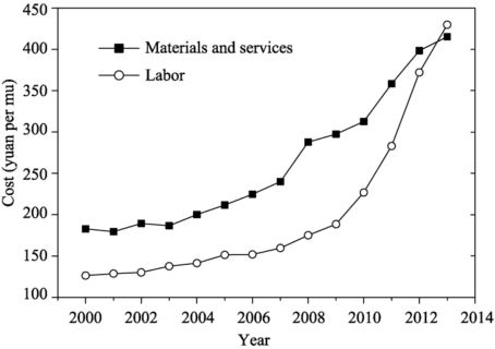
Figure 2 The labor, materials and service costs for China’s three main grain crops since 2000^Data source: National Agricultural Costs and Benefit Compilation
A rapid rise in labor costs, coupled with slow growth in agricultural revenues, substantially lowered the profits of agricultural production (Tian et al., 2009). In response to their loss of profits caused by rising labor costs, farmers usually adopted large-scale operations, such as using labor-saving machinery instead of expensive agricultural labor (Xin et al., 2011; Zhu et al., 2007), or planting more high-labor-productivity crops to maximize labor’s productivity (Tian et al., 2009). These responses can reduce the agricultural labor costs caused by rising labor prices. However, in some areas with unfavorable terrain that prevents famers from achieving rapid increases in labor productivity, when labor costs increase, farmlands in these areas will gradually be marginalized and then abandoned (Strijker, 2005; Li et al., 2011a).

3.3 Shrinking agricultural labor forces are the direct cause of farmland abandonment

Shrinking rural populations and a declining agricultural labor force are the corollary of urbanization. As the size of the agricultural labor force declines, farmers must improve their labor productivity to enable them to farm all of their land. In the context of rapid increases in farming opportunity costs, substituting human labor with machinery is the most effective way to improve productivity. Nonetheless, on marginal farmland, such as hilly and mountainous areas, because of the difficulties associated with adopting agricultural machinery, farmers choose to plant only crops with high-level labor productivity, and to reduce the areal extent of ​labor-intensive crops, resulting in larger area of monocultural cropping (MacDonald et al., 2000; Tian et al., 2009; Yan et al., 2016b). Certainly, adjustment of farming practices through structural change cannot improve labor productivity as efficiently as using machinery will, so with shrinking agricultural labor forces, rural households do not have enough time to farm all their land, so some of the land will be abandoned. Since land quality is not homogeneous in hilly and mountainous areas, farmers usually invest more in high quality farmland than in low quality farmland, so with a decrease in labor inputs, the marginal revenues from low quality land will decline at a faster rate, and low quality land will be abandoned first (Ding et al., 2009).
In Europe, the reduction of agricultural labor force is often synchronized with population decline, therefore, rural depopulation has been considered to be a very important driving force of farmland abandonment (Table 1), but it is not the case in China (Yan et al., 2016). The household registration system and land system reduce the possibility of settling down in cities for migrant workers (Sheng, 2014). Hence, outmigration of rural labor does not necessarily lead to depopulation, as the elderly parents and often also wife and children of the migrated laborer remain stay in the home village (Yan et al., 2016). According to the report of National Migrant Workers Survey 2015, male migrant workers accounted for 68.8% of the total (NBS, 2016).
The agricultural labor force is not only shrinking, it is also aging (Romero-Calcerrada et al., 2004; DGL, 2005). In some less-developed areas, given the developing economy and changes to traditional concepts, rural households are giving more attention to their children’s education, thereby further reducing the agricultural labor force and promoting farmland abandonment. For example, in the south of the Himalayas in Nepal, children aged 5 to 14 accounted for more than 1/5 of the total local population; these children have to date been directly or indirectly involved in agricultural production, so they are an important part of the agricultural labor force. Therefore, with an increase in the rate at which children are being enrolled in schools, farmland abandonment has become more serious (Khanal et al., 2006). In conclusion, given the declining size of the labor force, if farmers cannot improve labor productivity, some farmland will inevitably be taken out of production. In addition, rather than the ageing itself, the absence of a successor may more often lead to farmland abandonment in Europe (Schnicke, 2010; Terres et al., 2015).

3.4 Farmland abandonment is the result of multiple driving forces

Any land-use activity is integral to the country’s interrelated environmental, economic, and institutional systems (Barlowe, 1989). A change to one system can precipitate land-use changes, together with changes in other elements of other systems; but changes to other systems’ elements may promote or inhibit land-use changes, since there are positive and negative feedbacks loops in the composite systems. For example, after farmland has been abandoned, reforesting promotes the more frequent appearance of wild animals (e.g., wild boar and buffalo), which increases the risk of crop failures (depredated by wild animals). This increase in wildlife not only increases the costs of risks associated with agricultural production, but also the labor costs, because farmers have to spend more time preventing crops from being destroyed by wild animals. Cost increases thus accelerate the marginalization of farmland, and damage caused by wildlife has become a significant cause for farmland abandonment in China’s mountainous areas (Pointereau et al., 2008; Li et al., 2014b). In addition, the soil erosion that follows farmland abandonment (Harden, 1996; Khanal et al., 2006) and seed rains after forest restoration (Gellrich et al., 2007a) also have negative impacts on agricultural yields, which in turn increase the risk of farmland abandonment. Farmland marginalization and abandonment could be slowed by the implementation of government policies that support marginal regions, food prices rising induced by increasing demands or labor costs, and promoting new technologies and the development of energy crops (Campbell et al., 2008; Min, 2010; Li et al., 2011a; Campbell et al., 2013; Zumkehr et al., 2013). Therefore, the abandonment of arable land is a result of the combined effects of economic development, government policies, natural factors, and technological advances.

4 Factors that influence land distribution

Farmers will make the necessary adjustments to their land utilization in order to adapt to cost increases or output reductions brought about by the driving force of abandonment. There are, however, some factors that limit opportunities for making effective adjustments; these factors determine the spatial distribution of farmland abandonment (Pointereau et al., 2008; Terres, 2013; Zhang et al., 2014). Identifying the factors that influence abandonment enables us to understand the mechanisms of farmland abandonment, and provides the scientific references needed to simulate regional land-use changes and conduct a spatial evaluation of abandonment risk.

4.1 Farmland abandonment occurs mainly in mountainous areas

From the macro-scale point of view, in a region with comparable socioeconomic development levels and policies, farmland abandonment is more prone to occur in mountainous and hilly regions (Mather, 1998; Shao et al., 2015). For instance, survey data from the MAFF show that even if there is a direct subsidy policy for agriculture in mountainous or semi-mountainous areas (Hu, 2007), farmland abandonment rates in mountainous agricultural areas are 3 times as high as on the plains, and 2.5 times as high as in semi-mountainous areas (MAFF, 2011). The reason mountainous areas have a higher risk of agricultural abandonment is that they have some features that hinder agricultural mechanization and large-scale production, such as farmland fragmentation, steep slopes, long farming distances, and poor transportation (Baldock et al., 1996). Compared to flatlands, sloping lands in mountainous areas require more labor inputs, and these additional costs reduce marginal profits (Khanal et al., 2006). Because of their access to good transportation and farming conditions, cultivated lands around the metropolises in China were rarely abandoned, whereas farmland in the hills, mountains, and remote countryside has largely been abandoned because of its low soil fertility, weak agricultural infrastructure, and remoteness (Xu, 2010a).
Outdated management styles and ingrained traditional views also contribute to a higher probability of farmland abandonment in mountainous areas. Mountainous agricultural systems in Europe are small-scale and extensive (Baldock et al., 1996). These systems severely hamper making technological and structural adjustments, and in addition, mountain farmers’ traditional attitudes make it more difficult for them to adopt new agricultural technologies, thereby entailing a higher risk of farmland abandonment (Campagne et al., 1990). According to published case studies, farmland abandonment has only occurred in the plains in Eastern Europe—suggesting no significant relationship between abandonment and terrain (Prishchepov et al., 2012)—while elsewhere hilly and mountainous areas have been abandoned (Table 1). The reason for agricultural abandonment in Eastern Europe is distinct from the reasons for abandonment in other regions, and is closely related to its land system and agricultural policy reforms. Therefore, farmland marginalization in plain areas may be reversed. Recent research shows that from 2000 to 2012, areas of abandoned farmland in Eastern Europe that have been reused are much larger than the areas that have been newly abandoned (Estel et al., 2015). In short, the possibility of farmland abandonment is higher due to the presence of various conditions in mountainous areas that are adverse to farmland production (Khanal et al., 2006), and the probability of their reuse after abandonment is lower.

4.2 The distribution of abandonment is influenced by multilevel factors

Some researchers have summarized the spatial distribution of farmland abandonment. Within the same landform unit, different villages, different types of rural households, and different plots were found to have different risks and extents of farmland abandonment. Baumann et al. summarized the spatial distribution of abandoned land in Ukraine as basically being affected by the natural environment, land, location, population changes, and regional agricultural development levels (Baumann et al., 2011). Gellrich et al. (2007) argued that farmland abandonment and reforestation occur in areas where farm costs are high but outputs are low, and thus factors affecting farmland abandonment and reforestation are classified as being farming costs and benefits. The EU’s Joint Research Centre (JRC) reported that the influencing factors of farmland abandonment in Europe can be classified into three categories: poor environmental/biophysical suitability for agricultural activity, low farm stability and viability, and negative regional drivers (Terres et al., 2013). This summary indicates that natural conditions, labor attributes, the level of agricultural development, plot location, the economic situation, and agricultural policy affect the spatial distribution of land abandonment. As mentioned earlier, changing socioeconomic factors (urbanization and industrialization) are the leading drivers of land abandonment; declining rents are the fundamental cause of land abandonment; and the shortage of rural laborers is the direct cause. Consequently, in terms of these three aspects, we can classify the influencing factors into three types: labor attributes, farming conditions, and socioeconomic conditions (Table 2).
Table 2 Determinants of farmland abandonment at different levels
Levels Labor attributes Agricultural production
conditions
Socioeconomic
situations
Regional/village scale No. of agricultural laborers (-)
Labor participation (-)
Land area per agricultural laborer (+)
Percentage of off-farm laborers (+)
Percentage of full-time farms/farmers (-)
Mechanization (-)
Average elevation (+)
Average slope (+)
Temperature (~)
Precipitation (~)
Degree days (~)
Fragmentation (+)
Parcels per household (+)
Agricultural infrastructure (-)
Soil quality (-)
Average farming distance (+)
Average nearest distance from land parcel to road (±)
Average nearest distance from land parcel to forest edge (-)
Wild animal influence (+)
Average yield (-)
Farming opportunity cost (+)
Off-farm income (+)
Proportion of non-agricultural employment (+)
Percentage of non-agricultural GDP (+)
Per capita GDP (+)
% change of rural labor force and population (+)
Urbanization rate (+)
Distance to administrative center (±)
Road density (+)
Land rental rate (-)
Agricultural subsidy (-)
Household/
farm level
No. of agricultural laborers by household (-)
Household size (-)
Land area per agricultural laborer (+)
Average age of agricultural laborer in the household or farm (+)
Percentage of elderly agricultural laborers (+)
Percentage of male agricultural laborers (-)
Age of head of a household or farm (+)
Age of farm holder/head of household (+)
Dependency ratio (+)
Percentage of part-time farmers (+)
Education (±)
Household type
No. of pieces of agricultural machinery (-)
Farm size/No. of parcels (+)
Average area per parcel (-)
Average farming distance (+)
Soil quality (-)
Average yield of the household or farm (-)
Per capita income (+)
Agricultural income (-)
Non-farm income (+)
Percentage of non-farm income (+)
Parcel level Parcel size (-)
Shape index of the parcel (+)
Slope (+)
Elevation (+)
Soil quality (-)
Potential productivity (-)
Farm distance (+)
Distance from land parcel to nearest road (±)
Distance from land parcel to forest edge (-)

Note: (+), (-), (±), (~) represent the positive, negative, uncertain, and non-linear correlations between the influencing factors and abandonment respectively.

Comprised of the number of individuals in an economy who are either working or available for work, a labor force is characterized by age structures, sex ratios, and educational levels. Other descriptors of the labor force are dependency ratios, and the average farmland area per farmer, and we classify our data accordingly. Total agricultural labor capacity is comprised of the quantity and quality of the agricultural labor available. Generally, the smaller the labor force, the older the farmer, the lower the proportion of male farmers, the higher the dependency ratio, the fewer the number of full-time farms/farmers, and the higher the probability of land abandonment (Zhang et al., 2011a; Li et al., 2014b). The cultivated land per farmer and the number of farmers per mu reflect the relative abundance of labor resources, so the larger the cultivated area per farmer the greater the shortage of laborers, and the higher the risk of land abandonment (Li et al., 2014a; Xie et al., 2014; Zhang et al., 2014). In different types of rural households, labor force participants’ levels of education have different effects on land abandonment (Zhang et al., 2011a; Li et al., 2014a).
Agricultural production conditions affect the associated benefits and costs. Benefit-related factors include climate, soil, irrigation facilities, and distance to the forest edge. Cost-related factors include the land’s elevation, slope, fragmentation, commuting/tillage distance (accessibility), and level of mechanization. The higher the altitude, the steeper the slope, the more fragmented the land holding, the longer the commuting distance, the thinner the soil layer, the poorer the soil quality, the fewer the degree days, the more labor inputs required, the lower the productivity, and so the higher the risk of abandonment (Baldock et al., 1996; Doorn et al., 2007; Gellrich et al., 2007a; Gellrich et al., 2007b; Sklenicka et al., 2014; Xie et al., 2014). Improvements to agricultural infrastructure and mechanization are conducive to improving agricultural revenues and reducing labor inputs, thus helping to reduce farmland abandonment. Agricultural land that is closer to the edge of the forest and exposed to shade and seed rains is likely to have lower crop yields, implying higher probabilities of abandonment (Gellrich et al., 2007a; Xie et al., 2014). Crop yield is a more direct factor that is integral to agricultural revenues, and it is the most important factor in relation to the spatial distribution of land abandonment in flat western Russia (Prishchepov et al., 2113).
Socioeconomic situations are proxies for land abandonment drivers, and they are associated with increasing farming opportunity costs in relation to urbanization and industrialization, land rental rates, and agricultural subsidies. Farming opportunity costs are difficult to measure, especially in the absence of household survey data, so proxies that represent opportunities and wages of off-farm employment are used instead. At the regional level, they include the proportion of non-agricultural employment (or agricultural employment), reduction ratios of the rural labor force or rural population, the proportion of non-agricultural income, the urbanization rate, and per capita GDP (Gellrich et al., 2007a; Baumann et al., 2011; Xie et al., 2014). Distance to the nearest administrative center and road density to an extent, are used as proxies to reflect the total migrant labor cost, but their correlation is quite low (Prishchepov et al., 2013). The land rental rate used reflects both perfect land markets and the price of the land, so the higher the rental rate is, the lower the likelihood of abandonment (Zhang et al., 2014a; Terres et al., 2013; Shao et al., 2016).
The influencing factors of labor attributes, agricultural production conditions, and socioeconomic conditions perform differently at different levels. The spatial distribution of abandoned land can be explained by factors at the village and parcel levels, and it conforms to Von Thünen-Ricardo’s Rent Theory (Lambin et al., 2010; Prishchepov et al., 2013). The household is the basic decision-making unit of agricultural land use, and farmland abandonment is a result of the allocation of the household labor force. Hence, a household-level study is important to understanding the mechanisms of abandonment (Tian et al., 2009). Facing the rising opportunity cost of farming, farmers will optimize the allocation of their households’ labor and land resources, so different types of rural households have different ways of dealing with marginal land, and they abandon farmland for different reasons (Doorn et al., 2007; Zhang et al., 2011a; Li et al., 2014b). Besides, the influencing factors of different levels have different powers to explain the variance in probability of farmland abandonment. Zhang et al. analyzed the influencing factors on multi-scale farmland abandonment using multilevel regression analysis, which revealed that of the variances in the occurrence of land parcel abandonment, 80% can be explained by the attributes of individual land parcels, while only 7% and 13% can be explained by household and village level factors, respectively (Zhang et al., 2014).

4.3 The effects of influencing factors vary by region

Farmland abandonment is the outcome of interactions between multilevel factors. The complexities of the influencing factors lead to different results in different regions. Thus, some good indicators may fail to reveal land abandonment in some areas. For example, extensive land fragmentation is considered a crucial determinant of agricultural abandonment. Small parcel size not only impedes the efficient substitution of human labor with machinery, but also increases commuting costs, which in turn increase production costs and reduce labor productivity (Lusho et al., 1998; Vranken et al., 2004). Thus, the more extensive the fragmentation is, the greater the risk of farmland abandonment (Baudry et al., 2004; Bielsa et al., 2005). However, land fragmentation does not always lead to low productivity; it may be the result of diversification strategies adopted by farmers to reduce production risks associated with economic crises and social instability (Deininger et al., 2012). In this context, in some areas the higher the fragmentation is, the lower the rate of land abandonment (Sikor et al., 2009). As another example, the probability of land abandonment may increase with the distance from the parcel to the road, but it may also decrease with increasing distance. This positive correlation can be explained by noting that being near a road can reduce transportation costs and time (Alix-Garcia et al., 2012), so the further the travel distance is, the higher the likelihood of abandonment (Li et al., 2014b; Zhang et al., 2014). With regard to the negative correlation, farmers who are close to the road have more opportunities to access off-farm jobs, so the further the distance is, the less likelihood there is of abandonment (Hatna et al., 2011). Fundamentally, the distance from the land parcel to the road cannot be used as a direct indicator of the spatial distribution of abandoned farmland, since it does not reflect the real commuting distance, nor the farm’s opportunity cost, particularly given that dependence on transportation carries different weights in different types of agricultural land uses (Gellrich et al., 2007a). In the Carpathians of western Ukraine, for example, the abandonment rate in plain areas is higher than in mountainous areas, because the quality of farmland is better in the mountains (Baumann et al., 2011). In addition, regional agricultural policies may also undermine the explanatory power of primary influencing factors such as topography (Pointereau et al., 2008). In short, when selecting the factors that would be used to conduct the regional risk evaluation of abandonment or the spatial pattern simulation, the complexities and regional differences of the influencing factors required us to choose those that are closely related to the driving forces and reasons for abandonment in the study area.

5 Consequences of land abandonment

5.1 Regional variations of environmental consequences

After farmland has been abandoned, semi-natural artificial ecosystems without management gradually evolve into natural ecosystems, thereby changing the entire traditional agricultural landscape, and also having substantial ecological and environmental effects (MacDonald et al., 2000; Benayas et al., 2007; Zaragozí; et al., 2012). Existing research on the ecological and environmental effects of land abandonment have focused mainly on biodiversity and landscape diversity, the carbon sink function, soil erosion and restoration, and forest fires (Benayas et al., 2007). Among these, the study of biodiversity is the richest (Benayas et al., 2007; Zaragozí et al., 2012). Case studies have illustrated that there are obvious regional differences between the ecological and environmental consequences of land abandonment, though which are more positive than negative is still being debated. Some scholars have argued that land abandonment threatens some semi-natural habitats with a high ecological value, so this agricultural practice should be maintained (Fischer et al., 2012). Others have advocated that abandonment is a good opportunity to restore natural ecosystems and conserve biodiversity (Aide et al., 2004; Chazdon, 2008; Aide et al., 2012).
The most controversial argument that has been raised concerns the impact of land abandonment on landscape diversity and biodiversity (Queiroz et al., 2014). Since global agriculture has a long history, extensive farming has generated important ecological communities and ecosystems, where species diversity is even greater than in natural ecosystems (MacDonald et al., 2000). Previous studies indicate that more than 50% of the important biomes in Europe live on extensively managed farmland (Bignal et al., 1996), which is considered to be High Natural Value Farming that contributes to biodiversity (Doxa et al., 2010). Therefore, farmland abandonment and the natural ecological succession that follows can lead to the loss of species-rich habitats and the degradation of traditional agricultural landscapes with high conservation values (Fischer et al., 2012). Meanwhile the species that rely on these farmland ecosystems will disappear gradually, and among them, birds and arthropods are most susceptible to land abandonment (Anthelme et al., 2001; Doxa et al., 2010). Consequently, land abandonment can initiate a decline of currently abundant wild species (Stoate et al., 2001), as well as a decline in ecological and aesthetic values (Bignal et al., 1996). Most case studies in Europe provide evidence of the negative effects land abandonment has on ecological systems (MacDonald et al., 2000; Pointereau et al., 2008). Studies in Japan (Katoh et al., 2009) and Mexico (Garcia-Frapolli et al., 2007) have also found that the maintenance of traditional agricultural production and landscapes is conducive to the protection of endangered species. In addition, natural succession on abandoned land promotes the homogenization of vegetation, which in turn increases the fire risk (Vega-Garcıa et al., 2006; Benayas et al., 2007), and thus further reduces biodiversity because of the now-flourishing pyrophyte (Benayas et al., 2007).
Many scholars have also argued that land abandonment has more positive than negative effects on biodiversity. Navarro et al. (2012) questioned the environmental friendliness of extensive traditional agricultural practices, noting that rewilding an extensive farming landscape is conducive to promoting biodiversity and enhancing ecosystem services such as carbon sequestration and recreation. Therefore, they recommended rewilding as a possible land management option for marginal land in Europe. Queiroz et al. (2014) reviewed 276 papers and found that studies supporting the opinion that land abandonment had negative impacts on biodiversity are predominantly concentrated in Europe and Asia, whereas American studies have produced contrary results. Their further analyses concluded that the differences found are mainly determined by the measures, species, and time periods used by researchers. In terms of species diversity, the abandonment of farmland may lead to the reduction of a species adapted to the open habitat, and an increase in a species adapted to the closed forest landscape (Dunn, 2004). Moreover, the diversity of a revegetation community will increase with time after land abandonment (Bai et al., 2006).
Land-use change plays a key role in the terrestrial ecosystem’s carbon cycle. It is generally believed that the restoration of natural vegetation following land abandonment is a carbon sequestration process (Houghton et al., 1999; Ma et al., 2015), and the transition from cropland to secondary forest can increase soil carbon storage (Batlle-Bayer et al., 2010). Therefore, reforestation after land abandonment has greater carbon-sink effects, which will benefit eco-environments and mitigate the greenhouse effect. Kuemmerle et al. (2011) evaluated the carbon sequestration potential of large-scale farmland abandonment and the subsequent forest recovery in Ukraine after the collapse of the Soviet Union, and showed that this land-use change had a potential for carbon sequestration of 150 TcC from 1988 to 2007. Vuichard et al. (2008) found similar results in their assessment of the carbon sequestration potential in the Soviet Union from 1991 to 2000. From 2001 to 2008, China’s annual carbon sequestration increased by 5.87 Mt due to the Cropland Conversion Programme (Li, 2011b).
The natural restoration time varies considerably between regions with different climates, and it has different effects on the soil of abandoned land. Following farmland abandonment, revegetation will increase the soil infiltration rate, reduce surface flows, and enhance its water-holding capacity (Bruijnzeel, 2004), so it effectively reduces water loss and soil erosion (García-Ruiz et al., 1995; Molinillo et al., 1997; Bakker et al., 2008) and increases soil fertility (Robinson et al., 2003). However, in semiarid areas, slow revegetation increases the development of soil crusts that reduce infiltration and increase overland flows and soil erosion (Inbar et al., 2000; García-Ruiz et al., 2011). After the abandonment of slope farmlands and terraced fields, the lack of maintenance and followed by overgrazing increases surface roughness and surface and underground flows, so in the early stage abandonment in this area will increase the risk of natural hazards such as soil erosion, floods, and landslides (Harden, 1996; Khanal et al., 2006). In addition, land abandonment will affect the soil’s microbial community structure and biomass (Zeller et al., 2001).

5.2 Socio-economic effects

Compared with studies of ecological and environmental effects, there have been relatively few studies of the socio-economic effects of land abandonment, and even fewer have been based on good quantitative assessments. Different people have different opinions regarding the socio-economic impacts of cultivated land abandonment. Abandonment is, after all, a rational behavior by farmers (Cao et al., 2008; Xu, 2010b) in terms of economic usability. While in Europe rural residents generally have negative perceptions of the abandonment of farmland—which is mainly associated with inefficient use of the land (Ruskulea et al., 2013)—and the economic and aesthetic values of the abandoned land here are the lowest among different land-use types (Benjamin et al., 2007). Meanwhile, the characteristic wilderness of landscapes that is induced by land abandonment makes the farmers of this wild environment feel confused and out-of-control (Ruskulea et al., 2013).
Farmland abandonment causes a direct decline in grain acreage—which may lead to considerable reductions in local food production (Han et al., 2008)—and contributes to food shortages in areas where land has been abandoned (Feng et al., 2005; Khanal et al., 2006). However, the issue of food security only makes sense at a country level, so whether the abandonment of farmland has negative impacts on the food security issue needs a deeper discussion (Luo, 2012). Previous studies have indicated that the giant Grain for Green Programme (GGP), which aimed to turn slope cropland into forest, had a modest negative influence on food security (Xu et al., 2006), with overall grain reduction estimated at only 2% to 3% (Feng et al., 2005). The main reason for this small effect is that most of the farmland returned to the forest by the GGP, or abandoned by farmers, is poor, and has low productivity, so the real impact on grain yield reductions was less than the proportionate reduction of the sown area. In addition, we should note that abandonment is only an extreme result of land marginalization, which also includes seasonal abandonment and “recessive abandonment” such as transitioning from “two cropping rice to one cropping,” “paddy field turn into dry land,” and “intensive farming to extensive” (Liu et al., 2005; Wang, 2014). Hence, when discussing the impacts of land abandonment on food security, it is more reasonable to take into account the holistic aspects of land marginalization.
With the socio-economic development, the function of farmland also changes after its land-use transition (Song et al., 2015). In addition to its function as a source of food production, farmland also has social functions that include landscape aesthetics, leisure activities, entertainment, tourism, and farming’s cultural inheritance, the importance of which has been increasing dramatically (Buijs et al., 2013; Peng et al., 2014; Peng et al., 2015). Thus, one of the significant negative social effects of land abandonment is landscape degradation and rural decay, which leads to a loss of the traditional farming culture and its aesthetic values (Benjamin et al., 2007), as well as its decline as a tourism attraction (EU, 2004; Sayadi et al., 2009). Worse, however, is that farmland and rural marginalization interact to create a positive feedback loop, in which farmland abandonment occurs due to a rural exodus, which, in turn, further promotes rural marginalization (Brouwer et al., 2008; Pointereau et al., 2008), restricts the sustainable development of rural areas, and exacerbates the poverty of low-income rural households (Khanal et al., 2006).

6 Policies and instruments for land abandonment

Farmland abandonment first occurred in Europe quite early, and has developed rapidly, thereby arousing the concerns of governments and the EU. To reduce land abandonment, many European countries have introduced pointed policies. The measure with the widest scope is the Less Favoured Areas (LFAs) Scheme, which was updated as the Areas of Natural Constraint (ANCs) Scheme in 2015. LFAs were first launched in France in 1970, and initially applied only to marginal mountainous areas. They were later gradually extended to non-mountainous marginal areas that included disadvantaged rural areas with difficult climatic conditions, low soil productivity, and low population densities. Fifty-seven percent of the EU’s Utilized Agricultural Area has been classified as a less-favored area. The LFAs Scheme aimed to improve agricultural viability in constrained areas by issuing direct payments, and ensuring continued agricultural land use in order to maintain and promote sustainable farming systems and viable rural communities in these areas (EC, 2015). Implementation of the LFAs contributed to averting the abandonment of previously managed lands, but the effects varied among member states because of their unequal support for farmers in LFAs (Perrier-Cornet, 2010).
Coupled with rural depopulation, reductions to the agricultural labor force and an aging population, land abandonment has become a prominent problem for Japanese agriculture, especially in mountainous and semi-mountainous areas. To promote agricultural development and prevent the abandonment of agriculture and forestry in mountainous areas, the Japanese government introduced a direct subsidy policy for these areas in 2000 (Hu, 2007). Under that policy, each mountain farmer can receive an average subsidy of up to 80,000 yen per hectare (equivalent to more than twice the EU average area subsidy), and the government has also developed a policy that subsidizes rice production to stabilize rice farmers’ incomes (Gao et al., 2005). Since the implementation of these policies, the rate of land abandonment has begun to slow, and from 2000 to 2005, the rate of land abandonment in Japan’s mountainous areas was comparable to that in plain areas (MAFF, 2011).
In Asia and Latin America, a sharp decline in forest area owing to population growth and agricultural expansion has precipitated various natural eco-environmental problems and natural disasters, which in turn have aroused people’s desires for the ecosystem services provided by forests. Their land-use policies, therefore, tend to accelerate forest transition, and prevent farmland encroachments on forestland. New labor-intensive and yield-increasing technologies have improved the intensity and profitability of high-quality cultivated land, which has reduced farmers’ dependence on sloping farmland, and thus promoted marginal land abandonment and forest regeneration (Tachibana et al., 2001; Aide et al., 2004). In China, increasing yields and cropping indexes in the plain areas have contributed to a return of farmland to forests and grasslands, as well as improvements in the environment—all without compromising food security (Huang et al., 2009). However, due to the small extent of cultivated land per capita and the large proportion of sloping land, it is necessary that China strikes a balance between food security and ecological conservation (Shao et al., 2014). China abolished its agricultural tax in 2004, and increased its agricultural subsidies to enhance the motivation of farmers to grow grain (Gale et al., 2005). However, there are no priorities in the subsidies’ targets and no accommodation has been made for regional disparities in the subsidies’ standards, so the policies intended to benefit farmers have been ineffective in halting farmland abandonment in mountainous China (Zhang et al., 2014).
Experiences in Europe and Japan have indicated that agricultural subsidies in mountainous areas can alleviate land marginalization and slow land abandonment. Nonetheless, due to noteworthy regional variations in the environmental effects of land abandonment, policies designed to address land abandonment should not focus only on maintaining production on marginal land (van Berkel et al., 2011; Shao et al., 2015). They should also address the perceived negative effects of land abandonment (Renwick et al., 2013). The FAO has proposed tackling farmland abandonment by categorizing different abandonment situations (FAO, 2006b), and Renwick et al. (2013) concluded that policy designs for land abandonment should consider both the land’s capability and population density: areas with a low land capability and high population density should adopt multifunctional development (e.g., rural tourism); areas with a high land capability and low population density should promote agricultural development; areas with a low land capability and low population density should focus on nature conservation.
In addition to agricultural subsidies and supporting policies for marginal areas, measures to prevent land abandonment also include the following: (1) enhancing the efficiency of the allocation of land resources by improving the marketing of land, in order to prevent the abandonment of farmland with high-grade farming conditions (Shao et al., 2016); (2) improving farming conditions through land consolidation, road and infrastructure construction (Shao et al., 2015); (3) promoting the plantations of green organic products with higher economic values, as people’s desires for higher food quality increase their demands for these products (Baldock et al., 1996; Strijker, 2005); and (4) planting other viable crops such as biocrops (Campbell et al., 2008; 2013).
Research findings on the effects of abandonment will influence policymaking for regional ecological conservation and management (Queiroz et al., 2014), whereas the consequences of land abandonment due to regional differences require the policymaker to consider the comprehensive effects of abandonment in specific regions, and draft measures that will address the negative impacts of land abandonment. Meanwhile, as typical mountain farming systems or mountain villages with high nature and cultural services values require protection, policymakers should introduce special agricultural subsidies or support the development of tourism to maintain an environment-friendly farming culture and landscape, and to promote the sustainable development of mountainous rural areas.

7 Prospects for farmland abandonment

7.1 Regional and national monitoring of abandonment dynamics

Remote sensing and household surveys are two methods for obtaining information on land abandonment. Remote sensing technology has a great advantage for mapping large-scale agricultural abandonment, as it provides the whole spatiotemporal picture of land abandonment (Spera et al., 2014; Estel et al., 2015) as well as references for regional land-use simulations and policymaking (Renwick et al., 2013). Although a household survey can be used to explain the mechanisms behind abandoned agriculture (Li et al., 2014b; Zhang et al., 2014), it is time-consuming and cannot provide an overview of the total extent and pattern of land abandonment quickly. The survey population, the sampling method, and the survey technique influenced the abandonment rate obtained using this household survey, so it may not reflect the overall situation accurately. Given the sensitivity of the land abandonment topic (farmland cannot legally be abandoned), farmers may not report their own land abandonments accurately, and consequently the abandonment rate calculated using survey data might underestimate the actual abandonment rate (Hu et al., 2013). Most studies conducted in China use household survey methods to estimate abandonment data (Yang et al., 2015), while only a few studies have used remote sensing (Dong et al., 2011; Xie et al., 2014), because of the difficulties involved in mapping highly-fragmented and scattered farmland with this technology. Therefore, to fully understand the extent and pattern of abandoned land, a large-scale survey using multi-source remote sensing imagery of abandoned land is needed.

7.2 Trend and risk assessment

The global trend toward farmland abandonment has aroused the concerns of scholars and governments. Many researchers have used CAPRI, CLUE-S and Dyna-CLUE to simulate and forecast the spatiotemporal changes of land abandonment likely to occur in Europe (Verburg et al., 2009; Keenleyside et al., 2010; Terres et al., 2013; Terres et al., 2015), and thereby provide references for agricultural policymaking in Europe. China is still in the stage of rapid urbanization, and the rapid migration of the rural labor force is likely to be a long-term trend (Lu et al., 2012). How will this continuing rural exodus from China’s mountainous regions impact land abandonment? Which regions will experience the greatest impacts? These are some of the questions we need to address. It is therefore necessary to create statistical and spatially explicit models that can be used to predict the extent of abandonment. These models will allow the simulation of the evolving spatiotemporal process, and the evaluation of the risk of abandonment, by exploring the dynamic mechanisms of abandonment and identifying the factors that influence farmland abandonment. Because China’s mountainous regions cross several climate, agricultural, and economic zones, the causes of farmland abandonment in different zones may carry different weights. Therefore, when modeling the trend or risk of land abandonment, we should take into account regional factors such as climate, cropping systems, agricultural development, land rental markets, and socioeconomic development. Meanwhile, it is necessary that key factors of abandonment for different regions be identified using a substantial field survey.

7.3 Evaluation of the consequences and informed policymaking

Farmland abandonment is the main trend of land-use change in mountainous China. The objective of conducting research on land abandonment is to learn how this practice influences society and the environment. The effects of farmland abandonment largely determine what policies are adopted and which measures are taken to precipitate farmland abandonment and natural ecosystem restoration, or to prevent abandonment and maintain farming on marginal land. Therefore, the focus of land abandonment research is to evaluate the eco-environment and socio-economic effects of abandonment and their regional differences. Furthermore, given different regional effects, it is suggested that policies should be more specific and elaborated in greater detail. Land abandonment policies are not needed to maintain extensive farming on marginal land, or to leave it in a laissez-faire state. For example, in the Loess Plateau, where the eco-environment is fragile and soil erosion is serious, the land use policy should not only promote land abandonment, but also accelerate the process of ecological restoration through early-stage interventions that will reduce the negative effects caused by abandoned farmland.

The authors have declared that no competing interests exist.

[1]
Aide T M, Clark M L, Grau H Ret al., 2012. Deforestation and reforestation of Latin America and the Caribbean (2001-2010).Biotropica, 45(2): 262-271.Forest cover change directly affects biodiversity, the global carbon budget, and ecosystem function. Within Latin American and the Caribbean region (LAC), many studies have documented extensive deforestation, but there are also many local studies reporting forest recovery. These contrasting dynamics have been largely attributed to demographic and socio-economic change. For example, local population change due to migration can stimulate forest recovery, while the increasing global demand for food can drive agriculture expansion. However, as no analysis has simultaneously evaluated deforestation and reforestation from the municipal to continental scale, we lack a comprehensive assessment of the spatial distribution of these processes. We overcame this limitation by producing wall-to-wall, annual maps of change in woody vegetation and other land-cover classes between 2001 and 2010 for each of the 16,050 municipalities in LAC, and we used nonparametric Random Forest regression analyses to determine which environmental or population variables best explained the variation in woody vegetation change. Woody vegetation change was dominated by deforestation (541,835km2), particularly in the moist forest, dry forest, and savannas/shrublands biomes in South America. Extensive areas also recovered woody vegetation (+362,430km2), particularly in regions too dry or too steep for modern agriculture. Deforestation in moist forests tended to occur in lowland areas with low population density, but woody cover change was not related to municipality-scale population change. These results emphasize the importance of quantitating deforestation and reforestation at multiple spatial scales and linking these changes with global drivers such as the global demand for food. Resumen Los cambios en la cobertura de bosque tienen efectos directos sobre la biodiversidad, el ciclo global del carbono, y el funcionamiento de los ecosistemas. Muchos estudios en la region de America Latina y el Caribe han documentado extensa deforestacion; sin embargo, existen estudios locales que reportan recuperacion del bosque. Ambas dinamicas, deforestacion y reforestacion, han sido relacionadas con cambios demograficos y socioeconomicos. Por ejemplo, dinamicas poblacionales, como la migracion rural urbana, pueden estimular la recuperacion del bosque, mientras que el aumento en la demanda mundial de alimentos puede promover la expansion agricola. Dado a que ningun estudio ha evaluado conjuntamente los procesos de deforestacion y reforestacion a escala municipal o regional, no existe un analisis sobre de la distribucion espacial de estos procesos. Hemos superado esta limitacion al producir, simultaneamente, mapas del cambio en las coberturas de vegetacion lenosa y usos del suelo entre 2001 y 2010 para cada uno de los 16,050municipios de America Latina. Se utilizo el analisis no parametrico de regresion Random Forest para determinar cuales de las variables demograficas o medioambientales explican la variacion del cambio en vegetacion lenosa. Los cambios mas significativos en la cobertura de vegetacion lenosa fueron causados por procesos de deforestacion (541,835km2), particularmente en los biomas de bosque humedo, bosque seco, y en las sabanas o matorrales de America del Sur. Igualmente, se registro un aumento en la cobertura de vegetacion lenosa (362,430km2), especialmente en zonas aridas o empinados poco favorables para la agricultura industrial.La deforestacion en los bosques humedos tiende a ocurrir en zonas de baja elevacion y de poca densidad poblacional, sin embargo, los cambios en vegetacion lenosa no estuvieron relacionados con cambios en poblacion a nivel de municipio. Estos resultados enfatizan la importancia de cuantificar la deforestacion y la reforestacion a multiples escalas espaciales y de vincular estos cambios con acontecimientos globales, como el incremento mundial en la demanda de alimentos.

DOI

[2]
Aide T M, Grau H R, 2004. Globalization, migration, and Latin American ecosystems.Science, 305(5692): 1915-1916.ABSTRACT There is accumulating evidence in favour of the hypothesis that herring migrations are influenced by social learning. The "adopted-migrant hypothesis" postulates that recruit spawning herring learn migration patterns by schooling with older individuals. However, this learning can be interrupted if the stock is unstable or if there are lack of overlap between recruits and the adult stock. There have been five reported changes in the location of the wintering area of Norwegian spring spawning (NSS) herring during the last 50 years. These changes co-occur with the recruitment of relatively strong year classes to the spawning stock. Simulations of schools containing naïve and experienced fish have shown that when abundant enough, naïve individuals repel guidance from a minority of experienced individuals. This process is referred to as numerical domination. We argue that numerical domination obstruct social learning from adults to recruits and plays a key role in establishing new wintering areas in NSS herring.

DOI PMID

[3]
Alcantara C, Kuemmerle T, Prishchepov A Vet al., 2012. Mapping abandoned agriculture with multi-temporal MODIS satellite data.Remote Sensing of Environment, 124: 334-347.Agriculture is expanding and intensifying in many areas of the world, but abandoned agriculture is also becoming more widespread. Unfortunately, data and methods to monitor abandoned agriculture accurately over large areas are lacking. Remote sensing methods may be able to fill this gap though, especially with the frequent observations provided by coarser-resolution sensors and new classification techniques. Past efforts to map abandoned agriculture relied mainly on Landsat data, making it hard to map large regions, and precluding the use of phenology information to identify abandoned agriculture. Our objective here was to test methods to map abandoned agriculture at broad scales with coarse-resolution satellite imagery and phenology data. We classified abandoned agriculture for one Moderate Resolution Imaging Spectroradiometer (MODIS) tile in Eastern Europe (~1,236,000km 2 ) where abandoned agriculture was widespread. Input data included Normalized Difference Vegetation Index (NDVI) and reflectance bands (NASA Global MODIS Terra and Aqua 16-Day Vegetation Indices for the years 2003 through 2008, ~250-m resolution), as well as phenology metrics calculated with TIMESAT. The data were classified with Support Vector Machines (SVM). Training data were derived from several Landsat classifications of agricultural abandonment in the study area. A validation was conducted based on independently collected data. Our results showed that it is possible to map abandoned agriculture for large areas from MODIS data with an overall classification accuracy of 65%. Abandoned agriculture was widespread in our study area (15.1% of the total area, compared to 29.6% agriculture). We found strong differences in the MODIS data quality for different years, with data from 2005 resulting in the highest classification accuracy for the abandoned agriculture class (42.8% producer's accuracy). Classifications of MODIS NDVI data were almost as accurate as classifications based on a combination of both red and near-infrared reflectance data. MODIS NDVI data only from the growing-season resulted in similar classification accuracy as data for the full year. Using multiple years of MODIS data did not increase classification accuracy. Six phenology metrics derived with TIMESAT from the NDVI time series (2003-2008) alone were insufficient to detect abandoned agriculture, but phenology metrics improved classification accuracies when used in conjunction with NDVI time series by more than 8% over the use of NDVI data alone. The approach that we identified here is promising and suggests that it is possible to map abandoned agriculture at broad scales, which is relevant to gain a better understanding of this important land use change process.

DOI

[4]
Alcantara C, Kuemmerle T, Baumann Met al., 2013. Mapping the extent of abandoned farmland in Central and Eastern Europe using MODIS time series satellite data.Environmental Research Letters, 8(3): 1-9.The demand for agricultural products continues to grow rapidly, but further agricultural expansion entails substantial environmental costs, making recultivating currently unused farmland an interesting alternative. The collapse of the Soviet Union in 1991 led to widespread abandonment of agricultural lands, but the extent and spatial patterns of abandonment are unclear. We quantified the extent of abandoned farmland, both croplands and pastures, across the region using MODIS NDVI satellite image time series from 2004 to 2006 and support vector machine classifications. Abandoned farmland was widespread, totaling 52.5 Mha, particularly in temperate European Russia (32 Mha), northern and western Ukraine, and Belarus. Differences in abandonment rates among countries were striking, suggesting that institutional and socio-economic factors were more important in determining the amount of abandonment than biophysical conditions. Indeed, much abandoned farmland occurred in areas without major constraints for agriculture. Our map provides a basis for assessing the potential of Central and Eastern Europe- abandoned agricultural lands to contribute to food or bioenergy production, or carbon storage, as well as the environmental trade-offs and social constraints of recultivation.

DOI

[5]
Alix-Garcia J, Kuemmerle T, Radeloff V, 2012. Prices, land tenure institutions, and geography: A matching analysis of farmland abandonment in post-socialist Eastern Europe.Land Economics, 88(3): 425-443.This paper uses remote sensing data from 1989 to 2000 to examine the impacts of price liberalization, land tenure, and biophysical characteristics on farmland abandonment in the border region of Poland, Slovakia, and Ukraine. Using regression analysis and matching estimators, we find that differences in biophysical characteristics, rather than in tenure systems, best explain the variation in abandonment rates within Poland. The difference in abandonment rates between Poland and Slovakia partially results from differences in land reform strategy, and abandonment in Ukraine takes a unique trajectory because of the incompleteness of the land reform and the lack of outside opportunities for residents.

DOI

[6]
Andre M F, 1998. Depopulation, land-use change and landscape transformation in the French Massif Central.Ambio, 27(4): 351-353.The example of the Massif Central, which is the largest mountain area of France, illustrates a widespread type of European mountains: those located at middle altitudes (less than 2000 m), with a past economy based almost exclusively on agriculture and which today offer restricted touristic potentials. Such mountains are severely affected by depopulation which primarily controls contemporary landscape change, much more than climate fluctuations. The growing extension of forests and fallowlands induces feedback effects which combine with current economical trends to marginalize such mountain areas, which return to "mediaeval wilderness". This is especially the case in the central granitic highlands where islands of human life and activities appear more and more restricted. In contrast, some peri-urban and more scenic areas such as the volcanic mountains of the Cantal Massif and the Cha卯ne des Puys, promote tourism activities in natural parks in attempts to limit and halt depopulation. However, the maintenance of attractive landscapes faces two problems: the decreasing number of farmers and the cost of agri-environmental measures.

DOI

[7]
Anthelme F, Grossi J, Brun Jet al., 2001. Consequences of green alder expansion on vegetation changes and arthropod communities removal in the northern French Alps.Forest Ecology and Management, 145(1/2): 57-65.Green alder is a widespread shrub species in the Alps. The intense grazing practices of the last centuries relegated it to avalanche tracks on wet and steep slopes. However, it is currently colonizing abandoned meadows and pastures on relatively wet and drained soils at the subalpine and the montane belts, creating a dense shrub cover. The aim of this study is to assess the biodiversity changes induced during alder expansion by taxonomic and functional traits, using two representative taxa, i.e. vegetation and arthropods. The results show that the alder expansion strongly affects the 0.5-1m vegetation layer and the plant species richness as well as the biomass and composition of the arthropods active on the soil surface. Hymenoptera , Orthoptera and Coleoptera , which compose the major part of the arthropod biomass, decline significantly as the green alder canopy grows. Such changes in specific and functional diversity may have strong effects on the ecosystem functioning and particularly on the maintenance of the habitat of several endangered species such as the black grouse ( Tetrao tetrix L.). The impact of green alder on biodiversity must be taken into account as well as its functional role in the ecosystem before leading any management against its expansion.

DOI

[8]
Bai W, Jiao J, 2006. Analyses on diversity of primary natural restoration vegetation communities in abandoned croplands in the hilly-gulled region of the Loess Plateau.Research of Soil and Water Conservation, 13(3): 140-145. (in Chinese)The richness index(Margalef index),diversity indices(Simpson index and Shannon-Wiener index),Pielou evenness index,Sorenson index,Bray-Curtis index were used respectively to analyze the diversity of natural restoration vegetation communities in abandoned croplands in the hilly-gullied region of the Loess Plateau.The results showed that:(1) these 伪-diversity indices expect the richness index revealed a similar pattern.Diversity indices and evenness index increased gradully with the increase of abandoned time,but the change was not so fast;(2) Sorenson's similarity index(Cs) indicated that the similarity between every community and its nearest abandoned time was the highest.As abandoned time increased,plant communities developed continuously and the species composition changed while Bray-Curtis index showed the inverse trend.The fluctuation of diversity indices indicates that,to a certain extent,the studied area was fragmented.

DOI

[9]
Bakker M M, Govers G, van Doom Aet al., 2008. The response of soil erosion and sediment export to land-use change in four areas of Europe: The importance of landscape.Geomorphology, 98(3/4): 213-226.Erosion and sediment export have decreased enormously in the de-intensified areas, but slightly increased in the intensively cultivated area. The spatial pattern of land-use change in relation to other erosion and sediment export-determining factors appears to have a large impact on the response of soil erosion and sediment export to land-use change. That the drivers of abandonment of arable land and erosion coincide indicates that de-intensification leads to a more favourable landscape pattern with respect to reduction of erosion and sediment export. This mechanism applies not only within the study areas, but also among the European study areas where the process of intensification of some areas and de-intensification of others might result in an overall decrease of erosion and sediment yield through time.

DOI

[10]
Baldock D, Beaufoy G, Brouwer Fet al., 1996. Farming at the margins: Abandonment or redeployment of agricultural land in Europe. London/The Hague: Institute for European Environmental Policy Agricultural Economics Research Institute.

[11]
Barbier E B, Burgess J C, Grainger A, 2010. The forest transition towards a more comprehensive theoretical framework.Land Use Policy, 27(2): 98-107.Building on the contributions of Mather and others, this paper offers an approach for developing a more comprehensive theory of the forest transition. We argue that long-run changes in forest cover in a country or region cannot be separated from the overall pattern of land use changes. Moreover, this pattern is determined by relative land values; forest cover changes over time as the value of one land use relative to the value of its competing use changes over time. However, the actual values that are used to allocate land may be far from optimal; that is, the presence of market, policy and institutional failures can distort economic and political incentives that can lead to bias in favour of one type of land use over the other, and may ultimately explain why a forest transition may be delayed unnecessarily in some countries and regions.

DOI

[12]
Barlowe R, 1989(Original work published 1978) published 1978). Land Resources Economics: The Economics of Real Estate (Gu Shuzhong Trans.). Beijing: Beijing Agricultural University Press.

[13]
Batlle-Bayer L, Batjes N H, Bindraban P S, 2010. Changes in organic carbon stocks upon land use conversion in the Brazilian Cerrado: A review. Agriculture,Ecosystems & Environment, 137(1/2): 47-58.This paper reviews current knowledge on changes in carbon stocks upon land use conversion in the Brazilian Cerrado. First, we briefly characterize the savanna ecosystem and summarize the main published data on C stocks under natural conditions. The effects of increased land use pressure in the Cerrado and current uncertainties of estimations of changes in land cover and land use are reviewed next. Thereafter, we focus on soil organic carbon (SOC) dynamics due to changes in land use, particularly conversion to pastures and soybean-based cropping systems, and effects of management practices such as soil fertilization, crop rotations and tillage practices. Most studies considered here suggest that more intensive agriculture, which include no-till practices and the implementation of best or recommended management practices (RMP), reduces SOC losses after land use conversion from conventional tillage-based, monocropping systems; however, these studies focussed on the first 0.3m of soil, or less, and seldom considered full carbon accounting. To better estimate possible global warming mitigation with agriculture in the Cerrado more comprehensive studies are needed that analyse fluxes of the biogenic greenhouse gases (GHG; CO 2 , N 2 O and CH 4 ) to determine the net global warming potential (GWP). Follow up studies should include the application of an integrated modelling system, comprised of a Geographic Information System (GIS) linked to dynamic modelling tools, to analyse SOC dynamics and make projections for possible changes in net C flows in the Cerrado region upon defined changes in soil use and management.

DOI

[14]
Baudry J, Thenail C, 2004. Interaction between farming systems, riparian zones, and landscape patterns: A case study in Western France.Landscape and Urban Planning, 67(1-4): 121-129.We analyze the factors driving land use within and outside riparian zones in four small (about 800ha) watersheds in Brittany. The results show a difference between riparian and non-riparian zones (less used for grassland), but other factors are also important, such as field size or farm management type. In large farms, small fields are easily abandoned. A multivariate analysis with farm and field characteristics explains 30% of land use variation. Our results suggest that farm type deflects land use from the regional mode, so it is important, in the implementation of environmental zoning, to assess constraints at the farm level.

DOI

[15]
Baumann M, Kuemmerle T, Elbakidze Met al., 2011. Patterns and drivers of post-socialist farmland abandonment in Western Ukraine.Land Use Policy, 28(3): 552-562.Farmland abandonment restructures rural landscapes in many regions worldwide in response to gradual industrialization and urbanization. In contrast, the political breakdown in Eastern Europe and the former Soviet Union triggered rapid and widespread farmland abandonment, but the spatial patterns of abandonment and its drivers are not well understood. Our goal was to map post-socialist farmland abandonment in Western Ukraine using Landsat images from 1986 to 2008, and to identify spatial determinants of abandonment using a combination of best-subsets linear regression models and hierarchical partitioning. Our results suggest that farmland abandonment was widespread in the study region, with abandonment rates of up to 56%. In total, 6600 km(2) (30%) of the farmland used during socialism was abandoned after 1991. Topography, soil type, and population variables were the most important predictors to explain substantial spatial variation in abandonment rates. However, many of our a priori hypotheses about the direction of variable influence were rejected. Most importantly, abandonment rates were higher in the plains and lower in marginal areas. The growing importance of subsistence farming in the transition period, as well as off-farm income and remittances likely explain these patterns. The breakdown of socialism appears to have resulted in fundamentally different abandonment patterns in the Western Ukraine, where abandonment was a result of the institutional and economic shock, compared to those in Europe's West, where abandonment resulted from long-term socio-economic transformation such as urbanization and industrialization. (C) 2010 Elsevier Ltd. All rights reserved.

DOI

[16]
Benayas J M R, Martins A, Nicolau J Met al., 2007. Abandonment of agricultural land: An overview of drivers and consequences. CAB Reviews: Perspectives in Agriculture, Veterinary Science,Nutrition and Natural Resources, 2(57): 1-12.

[17]
Benjamin K, Bouchard A, Domon G, 2007. Abandoned farmlands as components of rural landscapes: An analysis of perceptions and representations.Landscape and Urban Planning, 83(4): 228-244.In spite of its importance in some agricultural landscape, abandoned farmland remains relatively little studied. Yet it is central to several land management issues: ecological (biodiversity), economic (agricultural or forest productivity) and landscape issues. In order to better address these issues, this study proposes to define how abandoned farmland is perceived in an intensive agricultural landscape. Using photographs, the perceptions of abandoned farmland (herbaceous and shrub dominated) and 5 other land uses (hay fields, corn fields, pastures, woodlots and plantations) were measured from a sample of 33 abandoned farmland owners in order to compare and rank the perceptions of abandoned farmland to that of other types of land use. Perceptions of landscape changes and the importance of abandoned farmland within properties were studied. The statistical analyses used allowed us to establish relationships between the different perceptions and the socio-economic characteristics and value indicators of the land owners. The analyses establish that abandoned farmland produces the most negative perceptions, followed by corn fields. Conversely, woodlots are the land use that is the most appreciated. The attitude towards the environment was one of the variables most often significant in explaining the perceptions encountered. Analysis of landscape evolution reveals an intensification of agricultural practices that may lead to the conversion of abandoned farmlands into cultivated land. Finally, abandoned farmland is perceived, at the scale of the individual property, as the land use having the least value (as opposed to corn fields) and being the least appreciated (as opposed to forests).

DOI

[18]
Bielsa I, Pons X, Bunce B, 2005. Agricultural abandonment in the North Eastern Iberian Peninsula: The use of basic landscape metrics to support planning.Journal of Environmental Planning and Management, 48(1): 85-102.Land abandonment is an important cause of changes in landscape patterns in the Mediterranean area. There is a need to monitor land use and land cover changes in order to provide quantitative evidence of the relationship between land abandonment and the formation of new landscape patterns. Appropriate management policies to encourage sustainable development can then be developed. This paper describes how to monitor landscape dynamics using different temporal land use and land cover data generated from field survey and airborne information. The results showed that the abandonment of agricultural land generally results in an increase of vegetation biomass. This process leads to homogenization of the landscape. In addition, abandonment promotes fragmentation of agricultural land. Based on these results, the paper discusses the implications for rural management policies concerning the abandonment of agricultural land and suggests recommendations for the development of such policies.

DOI

[19]
Bignal E M, McCracken D I, 1996. Low-intensity farming systems in the conservation of the countryside.Journal of Applied Ecology, 33(3): 413-424.1. The historical role of agriculture in creating semi-natural vegetation is still not fully appreciated by many ecologists, conservationists, policy-makers or the general public. Nor is the fact that for many European landscapes and biotopes of high nature conservation value, the only practicable, socially acceptable and sustainable management involves the continuation of low-intensity farming. Consequently, too much emphasis is placed on attempting to ameliorate damaging effects of agricultural management rather than supporting ecologically sustainable low-intensity farming practices. 2. More than 50% of Europe's most highly valued biotopes occur on low-intensity farmland. However, most of this farmland has no environmental policy directly affecting it; most management decisions are taken by farm businesses and determined primarily by European and national agricultural officials. As a result, there continues to be intensification or abandonment of traditional practices, changes which are equally damaging to the nature conservation value. 3. However, the nature conservation importance of low-intensity farming systems is gradually being recognized. Reforms and reviews of agriculture policy are providing a variety of potential opportunities for maintaining such systems. Unfortunately, initiating change through policy is a slow process. There is therefore also a pressing need to look for other opportunities to maintain surviving systems and, where possible, to reinstate those recently lost. 4. Although these systems may be considered low-intensity in terms of chemical inputs and productivity, they are usually high-intensity in terms of human labour. Therefore, the processes that make the low-intensity farmed countryside biologically rich and diverse must be understood, but at the same time mechanisms to make life easier and more rewarding for the people who work such farmland must be found. 5. Ecologists and conservationists should think less of 'remnants of habitat being left amongst farmland' and more of a farmland biotope for which optimum management practices need to be developed. At the same time the current emphasis on site-based conservation should be complemented by strategic initiatives that promote wise management of the wider countryside.

DOI

[20]
Brouwer F, van Rheenan T, Dhillion S Set al., 2008. Sustainable land management: Strategies to cope with the marginalisation of agriculture. Cheltenham, UK: Edward Elgar Publishing Ltd.

[21]
Brown D G, Johnson K M, Loveland T Ret al., 2005. Rural land-use trends in the conterminous United States, 1950-2000.Ecological Applications, 15(6): 1851-1863.

[22]
Bruijnzeel L A, 2004. Hydrological functions of tropical forests: Not seeing the soil for the trees?Agriculture, Ecosystems & Environment, 104(1): 185-228.Differing perceptions of the impacts on hydrological functions of tropical forest clearance and conversion to other land uses have given rise to growing and often heated debate about directions of public environmental policy in southeast Asia. In order to help bring more balance and clarity to such debate, this paper reviews a wide range of available scientific evidence with respect to the influence exerted by the presence or absence of a good forest cover on regional climate (rainfall), total and seasonal water yield (floods, low flows), as well as on different forms of erosion and catchment sediment yield under humid tropical conditions in general and in southeast Asia in particular. It is concluded that effects of forest disturbance and conversion on rainfall will be smaller than the average decrease of 8% predicted for a complete conversion to grassland in southeast Asia because the radiative properties of secondary regrowth quickly resemble those of the original forest again. In addition, under the prevailing ‘maritime’ climatic conditions, effects of land-cover change on climate can be expected to be less pronounced than those of changes in sea-surface temperatures. Total annual water yield is seen to increase with the percentage of forest biomass removed, with maximum gains in water yield upon total clearing. Actual amounts differ between sites and years due to differences in rainfall and degree of surface disturbance. As long as surface disturbance remains limited, the bulk of the annual increase in water yield occurs as baseflow (low flows), but often rainfall infiltration opportunities are reduced to the extent that groundwater reserves are replenished insufficiently during the rainy season, with strong declines in dry season flows as a result. Although reforestation and soil conservation measures are capable of reducing the enhanced peak flows and stormflows associated with soil degradation, no well-documented case exists where this has also produced a corresponding increase in low flows. To some extent this will reflect the higher water use of the newly planted trees but it cannot be ruled out that soil water storage opportunities may have declined too much as a result of soil erosion during the post-clearing phase for remediation to have a net positive effect. A good plant cover is generally capable of preventing surface erosion and, in the case of a well-developed tree cover, shallow landsliding as well, but more deep-seated (>302m) slides are determined rather by geological and climatic factors. A survey of over 60 catchment sediment yield studies from southeast Asia demonstrates the very considerable effects of such common forest disturbances as selective logging and clearing for agriculture or plantations, and, above all, urbanisation, mining and road construction. The ‘low flow problem’ is identified as the single most important ‘watershed’ issue requiring further research, along with the evaluation of the time lag between upland soil conservation measures and any resulting changes in sediment yield at increasingly large distances downstream. It is recommended to conduct such future work within the context of the traditional paired catchment approach, complemented with process-based measuring and modelling techniques. Finally, more attention should be paid to the underlying geological controls of catchment hydrological behaviour when analysing the effect of land use change on (low) flows or sediment production.

DOI

[23]
Buijs A E, Pedroli B, Luginbühl Y, 2006. From Hiking through farmland to farming in a leisure landscape: Changing social perceptions of the European landscape.Landscape Ecology, 21(3): 375-389.The idea that landscape has been created by human activities on a biophysical basis allows for clear cause–effect reasoning. However, landscape planning and management practice learns that it is impossible to neglect the social perception of landscape, i.e. the ways people think about nature and landscape. It is the result of social research and human sciences of the last decade that a differentiation in views of nature and landscape can be identified in the different groups of social actors in the landscape. Case studies from France and the Netherlands show a marked change in values attributed to nature and landscape in the end of the last century. Social demand for landscape is growing and a shift from a functional image of nature and landscape to a more hedonistic image like the Arcadian and wilderness images has taken place. Comparing the Netherlands with France and rural with urban inhabitants, the influence of urbanisation is evident in this process. It is further shown that images of nature vary considerably between for example farmers, urban residents, hunters and conservationists. The way people perceive landscape seems determined by their functional ties with the landscape and the social praxis in which they encounter the landscape. It is concluded that the concept of landscape is nearer to the lifeworld of people than the abstract notions of nature and biodiversity. This implies a big challenge both for national and international landscape policies and for local landscape management initiatives to be developed, taking into due consideration both the material and immaterial nature of landscape.

DOI

[24]
Campagne P, Carrere G, Valceschini E, 1990. Three agricultural regions of France: Three types of pluriactivity.Journal of Rural Studies, 6(4): 415-422.The three kinds of pluriactivity are very unlike. They show that, in France, agricultural development will in future be linked to rural development to a far greater extent.

DOI

[25]
Campbell J E, Lobell D B, Genova R Cet al., 2008. The global potential of bioenergy on abandoned agriculture lands.Environmental Science & Technology, 42(15): 5791-5794.Converting forest lands into bioenergy agriculture could accelerate climate change by emitting carbon stored in forests, while converting food agriculture lands into bioenergy agriculture could threaten food security. Both problems are potentially avoided by using abandoned agriculture lands for bioenergy agriculture. Here we show the global potential for bioenergy on abandoned agriculture lands to be less than 8% of current primary energy demand, based on historical land use data, satellite-derived land cover data, and global ecosystem modeling. The estimated global area of abandoned agriculture is 385-472 million hectares, or 66-110% of the areas reported in previous preliminary assessments. The area-weighted mean production of above-ground biomass is 4.3 tons ha(-1) y(-1), in contrast to estimates of up to 10 tons ha(-1) y(-1) in previous assessments. The energy content of potential biomass grown on 100% of abandoned agriculture lands is less than 10% of primary energy demand for most nations in North America, Europe, and Asia, but it represents many times the energy demand in some African nations where grasslands are relatively productive and current energy demand is low.

DOI PMID

[26]
Campbell J E, Lobell D B, Genova R Cet al., 2013, Seasonal energy storage using bioenergy production from abandoned croplands.Environmental Research Letters, 8(3): 1-7.Bioenergy has the unique potential to provide a dispatchable and carbon-negative component to renewable energy portfolios. However, the sustainability, spatial distribution, and capacity for bioenergy are critically dependent on highly uncertain land-use impacts of biomass agriculture. Biomass cultivation on abandoned agriculture lands is thought to reduce land-use impacts relative to biomass production on currently used croplands. While coarse global estimates of abandoned agriculture lands have been used for large-scale bioenergy assessments, more practical technological and policy applications will require regional, high-resolution information on land availability. Here, we present US county-level estimates of the magnitude and distribution of abandoned cropland and potential bioenergy production on this land using remote sensing data, agriculture inventories, and land-use modeling. These abandoned land estimates are 61% larger than previous estimates for the US, mainly due to the coarse resolution of data applied in previous studies. We apply the land availability results to consider the capacity of biomass electricity to meet the seasonal energy storage requirement in a national energy system that is dominated by wind and solar electricity production. Bioenergy from abandoned croplands can supply most of the seasonal storage needs for a range of energy production scenarios, regions, and biomass yield estimates. These data provide the basis for further down-scaling using models of spatially gridded land-use areas as well as a range of applications for the exploration of bioenergy sustainability. (letter)

DOI

[27]
Cao Z, He J, Liang L, 2008. Economic analysis of farmland abandonment and the policy responses.Journal of Agrotechnical Economics, (3): 43-46. (in Chinese)

[28]
Chazdon R L, 2008. Beyond deforestation: Restoring forests and ecosystem services on degraded lands.Science, 320(5882): 1458-1460.Abstract Despite continued forest conversion and degradation, forest cover is increasing in countries across the globe. New forests are regenerating on former agricultural land, and forest plantations are being established for commercial and restoration purposes. Plantations and restored forests can improve ecosystem services and enhance biodiversity conservation, but will not match the composition and structure of the original forest cover. Approaches to restoring forest ecosystems depend strongly on levels of forest and soil degradation, residual vegetation, and desired restoration outcomes. Opportunities abound to combine ambitious forest restoration and regeneration goals with sustainable rural livelihoods and community participation. New forests will require adaptive management as dynamic, resilient systems that can withstand stresses of climate change, habitat fragmentation, and other anthropogenic effects.

DOI PMID

[29]
Cramer V A, Hobbs R J, Standish R J, 2008. What’s new about old fields? Land abandonment and ecosystem assembly.Trends in Ecology and Evolution, 23(2): 104-112.Environmental and socio-economic changes are leading to increased levels of land abandonment worldwide. The assembly of plant communities on old fields has informed much ecological theory, which in turn has facilitated efforts at ecological restoration. The interaction of the cultivation legacy with inherent soil and vegetation characteristics will determine the dynamics of plant community assembly on old fields and indicate the level of effort required to restore historical vegetation states. The abandonment of traditional agricultural lands in some areas will create old fields that require limited or no restoration. Yet intensification of agriculture and rapid environmental change will lead to increasing numbers of old fields that show little recovery towards an historic vegetation state. The restoration of these old fields will pose significant scientific and policy challenges.

DOI PMID

[30]
Deininger K, Jin S, 2009. Land rental markets in the process of rural structural transformation: Productivity and equity impacts in China.Journal of Comparative Economics, 37(4): 629-646.Although the importance of land rental for overall economic development and development of the non-agricultural economy has long been recognized in theory, empirical evidence on factors that can promote or impede operation of such markets and their productivity and equity impacts, especially in rapidly developing economies with rather equal land endowments, remains limited. A large household level panel is used to illustrate the large contribution of land markets to occupational diversification, productivity of land use, and household welfare. Factors affecting land market participation are derived from a household model with transaction cost and individual ability. Results suggest that, by transferring land from less able and more affluent households who joined the non-farm sector to poorer ones with ample family labor, land markets are critical not only for non-agricultural growth but, by allowing more effective use of potentially idle land can contribute to significant productivity gains. Policy implications are derived.

DOI

[31]
Deininger K, Savastano S, Carletto C, 2012. Land fragmentation, cropland abandonment, and land market operation in Albania.World Development, 40(10): 2108-2122.Albania's radical farmland distribution is credited with averting an economic crisis and social unrest during the transition. But many believe it led to a holding structure too fragmented to be efficient, and that public efforts to consolidate plots are needed to lay the foundation for greater rural productivity. Farm-level data from the 2005 Albania LSMS allow us to explore this quantitatively. We find no support for the argument that fragmentation reduces productivity. However, producers fail to utilize about 10% of the country's productive land, and this land has, in the majority of cases, been idle for at least 5 years. Farmers quote inefficiently-small plots as the reason for this in very few cases, casting doubt on the scope for land consolidation to solve this issue. Instead, the data are consistent with the notion of land market imperfections, which can be traced to gaps in the legal and policy framework, as well as inefficiencies in registry operations, leading to land abandonment on a large scale. To maintain the productive potential of Albania's rural economy and, if and when needed, the ability to conduct consolidation in a cost-effective and sustainable manner, it will be critical to complement the emphasis on consolidation with an effort to address those gaps and inefficiencies on a priority basis. (C) 2012 Elsevier Ltd. All rights reserved.

DOI

[32]
DGL, 2005. Land abandonment, biodiversity and the CAP. Utrecht: Government Services for Land and Water Management of the Netherlands (DGL).

[33]
Díaz G I, Nahuelhual L, Echeverría Cet al., 2011. Drivers of land abandonment in Southern Chile and implications for landscape planning.Landscape and Urban Planning, 99(3/4): 207-217.

[34]
Ding G, Liu C, Huang L, 2009. A theoretical analysis and empirical research of marginalization of agricultural land in hilly-mountainous area under farmer-benefiting policy: A case study of Tongcheng County in Hubei Province.Geographical Research, 28(1): 109-117. (in Chinese)In the hilly-mountainous area in central China,agricultural land intensity is decreasing due to seasonal or all-year abandonment.This causes marginalization of agricultural land despite farmer-benefiting policies.By theoretical and empirical analysis,some reasons are found out as follows: 1.During the industrialization and urbanization process,farmers benefit more from urban employment than staying in farming.2.The agricultural ecological environment of hilly-mountainous area is so bad that the farmland's marginal revenue decreases;3.The farmer-benefiting policies are not the intended incentives in the hilly-mountainous area;ecological policies does not accord with agricultural policy,which aggravates local marginalization of agricultural land.Marginalization of agricultural land is rational behavior by farmers,but the process is significant to national food security and ecological construction.Marginalization of agricultural land in the hilly-mountainous area is driven by the multiple factors.In order to solve the phenomenon we must commence from the nature,economy,policy and so on to improve the agricultural environment,innovate agricultural organization system and technology,transform traditional farming,develop modern highly-effective characteristic agriculture,and increase marginal revenue of the farmland.In the meantime,national agricultural incentive policy should accord with ecological protection policy.The governments should adopt different subsidy methods in different areas,that is to say,they should adopt more special subsidy policies in the hilly-mountainous area under fragile ecology conditions.

DOI

[35]
Dong J, Liu J, Yan Het al., 2011 Spatio-temporal pattern and rationality of land reclamation and cropland abandonment in mid-eastern Inner Mongolia of China in 1990-2005.Environmental Monitoring and Assessment, 179(1-4): 137-153.The Mid-eastern Inner Mongolia of China, a typical agro-pastoral transitional zone, has undergone rapid agricultural land use changes including land reclamation and cropland abandonment in past decades due to growing population and food demand, climatic variability, and land use policy such as the "Grain for Green" Project (GFG Project). It is significant to the regional ecology and sustainability to examine the pattern and its rationality of land use change. The processes of land reclamation and cropland abandonment were accessed by using land use change dataset for four periods of 1990, 1995, 2000, and 2005, derived from the interpretation of Landsat TM images. And then the rationality of land reclamation and cropland abandonment was analyzed based on the habitat suitability for cultivation. The results indicated that: (1) land reclamation was the dominant form of agricultural land use change from 1990 to 2005, the total cropland area increased from 64,954.64 km(2) in 1990 to 76,258.51 km(2) in 2005; However, the speed of land reclamation decreased while cropland abandonment increased around 2000. The Land Reclamation Degree decreased from 1995-2000 to 2000-2005, meanwhile, Cropland Abandonment Degree increased. (2) As for the habitat suitability levels, moderately and marginally suitable levels had largest areas where cropland was widespread. Pattern of agricultural land use trended to become more rational due to the decrease of land reclamation area in low suitable levels and the increase of cropland abandonment in unsuitable area after 2000. (3) The habitat suitability-based rationality analysis of agricultural land use implicated that the GFG Project should take cultivation habitat suitability assessment into account.

DOI PMID

[36]
Doorn A M V, Bakker M M, 2007. The destination of arable land in a marginal agricultural landscape in South Portugal: An exploration of land use change determinants.Landscape Ecology, 22(7): 1073-1087.This research attempts to investigate what drives three conversions of arable land during the period 1985–2000 in a marginal agricultural landscape in Southern Portugal: afforestation of arable land, abandonment of arable land and regeneration of the agro-silvo-pastoral system. This was done by exploring the associations between these changes and a selection of both biophysical and socio-economic variables in a study area of 44 square km. For each conversion of arable land into one of the three other land use types the descriptive power of the various independent variables were evaluated using logistic regression. By comparing different statistical models (one containing only the biophysical attributes, another model containing only the socio-economic variables and finally a model containing both types of variables) the relative importance of socio-economic and biophysical variables was evaluated. The results show that both the biophysical and socio-economic variables were significantly associated with the occurrences of the land use changes. However, the models containing only the socio-economic variables were stronger related to occurrences of afforestation and regeneration of the montado, whereas the biophysical variables were more related to land abandonment. The landowner type was a significant descriptive variable across all land use change models. The results suggest that local socio-economic factors are significant in explaining the pattern of the conversion of arable land in the study area and for this reason the variety of landowners’ response to the physical conditions deserves more attention in land use change modelling.

DOI

[37]
Doxa A, Bas Y, Paracchini M Let al., 2010. Low-intensity agriculture increases farmland bird abundances in France.Journal of Applied Ecology, 47(6): 1348-1356.Summary 1. 68Farmland biodiversity continues to decline mainly because of agricultural intensification and land abandonment. Agri-environment schemes can be designed to halt this loss by favouring extensification of agricultural practices and through sympathetic management of field boundaries and fallow land. In Europe, High Nature Value (HNV) farmland is defined as low-intensity farmland supporting or associated with a high rate of biodiversity, in terms of species richness or habitat diversity and therefore plays a crucial role in the maintenance of European biodiversity. However, no large-scale analysis has explored the role of these areas in achieving conservation goals. 2. 68We analysed information from widely used indicators in order to describe the impact of low-intensity agriculture on farmland biodiversity in France. We used the HNV farmland indicator, based on agricultural statistics such as the Farm Structure Survey and the grassland survey, and common bird indicators, i.e. the Farmland Bird Indicator (FBI), the Community Specialization Index (CSI) and species richness indexes, based on the French Breeding Bird Survey. 3. 68Temporal trends in the farmland bird indicator showed that populations of farmland birds were more likely to increase inside HNV areas compared to non-HNV areas. Although species richness is not higher within HNV farmland, bird communities are composed by more specialist species than in non-HNV areas. In addition, these specialist bird species are significantly more abundant in HNV areas. 4. 68 Synthesis and applications . Further farmland biodiversity decline is potentially reversible through an appropriate management of HNV areas. Existing and future agri-environment schemes should focus on preserving and extending HNV farmland, by favouring the maintenance of low-intensity agriculture and landscape complexity. Priority should be given to preserving diversity at the community level, with the help of adequate indicators, such as the ones presented here. The role of HNV farmland or similar concepts in combining agriculture and biodiversity goals should be further analysed and further used as large-scale conservation tools.

DOI

[38]
Dunn R R, 2004. Recovery of faunal communities during tropical forest regeneration.Conservation Biology, 18(2): 302-309.Abstract Abstract:68 As mature tropical forests are cleared, secondary forests may play an important role in the conservation of animal species, depending on how fast animal communities recover during forest regeneration. I reviewed published studies on the recovery of animal species richness and composition during tropical forest regeneration. In 38 of the 39 data sets I examined, conversion of forest to agriculture or pasture substantially reduced species richness. Given suitable conditions for forest recovery, the species richness of the animal taxa considered can be predicted to resemble that of mature forests roughly 20–40 years after land abandonment. At least for ants and birds, however, recovery of species composition appears to take substantially longer than recovery of species richness. Because species richness for many taxa appears to recover relatively rapidly in secondary forests, conservation of secondary forests may be an effective investment in future diversity. The slower recovery of species composition indicates, however, that some species will require stands of mature forest to persist.

DOI

[39]
Estel S, Kuemmerle T, Alcántara Cet al., 2015. Mapping farmland abandonment and recultivation across Europe using MODIS NDVI time series.Remote Sensing of Environment, 163: 312-325.Farmland abandonment is a widespread land-use change in temperate regions, due to increasing yields on productive lands, conservation policies, and the increasing imports of agricultural products from other regions. Assessing the environmental outcomes of abandonment and the potential for recultivation hinges on incomplete knowledge about the spatial patterns of fallow and abandoned farmland, especially at broad geographic scales. Our goals were to develop a methodology to map active and fallow land using MODIS Normalized Differenced Vegetation Index (NDVI) time series and to provide the first European-wide map of the extent of abandoned farmland (cropland and grassland) and recultivation. We used a geographically well-distributed training dataset to classify active and fallow farmland annually from 2001 to 2012 using a Random Forests classifier and validated the maps using independent observations from the field and from satellite images. The annual maps had an average overall accuracy of 90.1% (average user's accuracy of the fallow class was 73.9%), and we detected an average of 128.7 million hectares (Mha) of fallow land (24.4% of all farmland). Using the fallow/active time series, we mapped fallow frequency and hotspots of farmland abandonment and recultivation of unused farmland. We found a total of 46.1Mha of permanently fallow farmland, much of which may be linked to abandonment that occurred after the dissolution of the Eastern Bloc. Up to 7.6Mha of farmland was additionally abandoned from 2001 to 2012, mainly in Eastern Europe, Southern Scandinavia, and Europe's mountain regions. Yet, recultivation is widespread too (up to 11.2Mha) and occurred predominantly in Eastern Europe (e.g., European Russia, Poland, Belarus, Ukraine, and Lithuania) and in the Balkans. We also tested the robustness of our maps in relation to different abandonment and recultivation definitions, highlighting the usefulness of time series approaches to overcome problems when mapping transient land-use change. Our maps provide, to our knowledge, the first European-wide assessment of fallow, abandoned and recultivated farmland, thereby forming a basis for assessing the environmental outcomes of abandonment and recultivation and the potential of unused land for food production, bioenergy, and carbon storage.

DOI

[40]
European Commission (EC), 2009. Adapting to climate change: The challenge for European agriculture and rural areas. Annex to the Staff Working Document SEC(2009) 417.

[41]
European Commission (EC), 2015. Rural development 2014-2020.1).Viewed on 4th Sep 2015

[42]
European Union, 2004. Land abandonment and biodiversity in relation to the 1st and 2nd pillar of the EU's commonagricultural policy. Outcome of an international seminar in Sigulda, Latvia.

[43]
Fang C, Du Y, Wang M, 2009. Migration and labor mobility in China. New York: United Nations Development Programme, Human Development Report Office.

[44]
FAO, 2006a. The role of agriculture and rural development in revitalizing abandoned/depopulated areas. Food and Agriculture Organization of the United Nations, Riga.

[45]
FAO, 2006b. Agriculture and the Environment: Changing Pressures, Solutions and Trade-offs. Rome.ENVIRONMENT, PERSPECTIVE, Pressure, PRESSURES, Solutions, trade-offs, WORLD

[46]
Feng Z, Yang Y, Zhang Yet al., 2005. Grain-for-green policy and its impacts on grain supply in West China.Land Use Policy, 22(4): 301-312.China's grain-for-green policy of converting steep cultivated land to forest and grassland is one of the most important initiatives to develop its western inland regions. Using a multi-objective programming model, this study assessed the impacts of this policy in the upper reaches of the Yangtze River and the upper and middle reaches of the Yellow River. In addition to the strategic planning of converting cultivated land to forest and grassland and its associated impacts, three other scenarios were simulated. Results showed that impacts on grain supply at the national level were in the range of 2-3%. These results suggest that the proposed policy might not have a major impact on China's future grain supply and the world grain market. At the local level, however, impacts could be significant.

DOI

[47]
Fischer J, Hartel T, Kuemmerle T, 2012. Conservation policy in traditional farming landscapes.Conservation Letters, 5(3): 167-175.Many traditional farming landscapes have high conservation value. Conservation policy in such landscapes typically follows a preservation strategy, most commonly by providing financial incentives for farmers to continue traditional practices. A preservation strategy can be successful in the short term, but it fails to acknowledge that traditional farming landscapes evolved as tightly coupled socialecological systems. Traditionally, people received direct benefits from the environment, which provided a direct incentive for sustainable land use. Globalization and rural development programs increasingly alter the social subsystem in traditional farming landscapes, whereas conservation seeks to preserve the ecological subsystem. The resulting decoupling of the socialecological system can be counteracted only in part by financial incentives, thus inherently limiting the usefulness of a preservation strategy. An alternative way to frame conservation policy in traditional farming landscapes is a transformation strategy. This strategy acknowledges that the past cannot be preserved, and assumes that direct links between people and nature are preferable to indirect links based on incentive payments. A transformation strategy seeks to support community-led efforts to create new, direct links with nature. Such a strategy could empower rural communities to embrace sustainable development, providing a vision for the future rather than attempting to preserve the past.

DOI

[48]
Foley J A, DeFries R, Asner G Pet al., 2005. Global consequences of land use.Science, 309(22): 570-574.Land use has generally been considered a local environmental issue, but it is becoming a force of global importance. Worldwide changes to forests, farmlands, waterways, and air are being driven by the need to provide food, fiber, water, and shelter to more than six billion people. Global croplands, pastures, plantations, and urban areas have expanded in recent decades, accompanied by large increases in energy, water, and fertilizer consumption, along with considerable losses of biodiversity. Such changes in land use have enabled humans to appropriate an increasing share of the planet's resources, but they also potentially undermine the capacity of ecosystems to sustain food production, maintain freshwater and forest resources, regulate climate and air quality, and ameliorate infectious diseases. We face the challenge of managing trade-offs between immediate human needs and maintaining the capacity of the biosphere to provide goods and services in the long term.

DOI PMID

[49]
Gan N, Yin Z, Tan Z, 2015. China Household Finance Survey Report 2014. Chengdu: Southwestern University of Finance and Economics Press.

[50]
Gale F, Lohmar B, Tuan F, 2005. China’s New Farm Subsidies. Electronic Outlook Report from the Economic Research Service, US Department of Agriculture.

[51]
Gao Z, Cui J, Hao J, 2005. Agricultural subsidy policy of developed country a and its implication.Forward Position, (1): 92-94.

[52]
Garcia-Frapolli E, Ayala-Orozco B, Bonilla-Moheno Met al., 2007. Biodiversity conservation, traditional agriculture and ecotourism: Land cover/land use change projections for a natural protected area in the northeastern Yucatan Peninsula, Mexico.Landscape and Urban Planning, 83(2/3): 137-153.In addition to preserving ecosystems and biodiversity, natural protected areas (NPAs) in Mexico are homelands for people, largely indigenous, who traditionally base their resource management on a multiple use strategy. We analyzed land use and land cover changes in the Otoch Ma-x Yetel Kooh NPA in the northeastern Yucatan Peninsula, Mexico, where Yucatec Maya recently incorporated ecotourism to their set of economic activities. We evaluated changes in land use using vegetation maps from 1999 to 2003 and predicted vegetation cover in 2011 by developing a cellular automata and Markovian chains model. We observed slight increases in the area covered by medium stages of secondary succession, while new milpa plots appeared in areas of all succession stages. We used three scenarios to predict land cover in 2011: (a) milpa agriculture implemented at the same rate; (b) milpa agriculture decreases due to the growing demand of ecotourism; and (c) milpa agriculture disappears due to parceling of communally owned land. All scenarios predict slight increases in the area covered by secondary succession at the expense of milpas or younger stages of succession, with no major differences between the three predictive scenarios. Our results provide guidelines for managing the NPA, suggesting that biodiversity conservation, traditional agriculture and ecotourism are compatible activities.

DOI

[53]
García-Ruiz, J M, Lasanta, T, Ortigosaet al., 1995. Sediment yield under different land uses in the Spanish Pyrenees.Mountain Research and Development, 15: 229-240.The effects of different land uses on soil conservation and sediment yield were studied by means of experimental plots and other direct and indirect evidence in the Central Spanish Pyrenees. The purpose was to compare the traditional land uses with the present ones, in order to explain some of the landscape characteristics and, especially, the state of soil conservation. The work attempts to identify the land uses that contribute more to the sustainability of a mountain area affected by significant and generalized land-use changes in recent decades. The results obtained suggest that the traditional cereal agriculture greatly contributes to soil erosion and responds rapidly to precipitation. This probably accounts for the state of damage of many soils used for cereal cultivation over many centuries. Meadows yield much water and few sediments, and dense shrub cover yields very little water and very few sediments. The burning of the dense shrub cover produces a sudden increase in runoff and erosion, although a few months later sediment yield reverts back to rates similar to those prevailing before the fire. Now, the reduction of the area of cultivated land, the abandonment of shifting agriculture, the replacement of cereals by meadows, and the expansion of bushes in the former cultivated fields will cause a decrease in sediment yield.

DOI

[54]
García-Ruiz J M, Lana-Renault N, 2011. Hydrological and erosive consequences of farmland abandonment in Europe, with special reference to the Mediterranean region: A review.Agriculture, Ecosystems & Environment, 140(3/4): 317-338.Farmland abandonment is a major problem in parts of Europe, particularly in mountain areas and semiarid environments. In such places, farmland abandonment represents a significant land use change from cropping to a complex of plant successions. The present study assesses the hydromorphological effects of land abandonment in Europe, and the consequences thereof with respect to water resource availability and soil erosion. The evolution of abandoned fields depends on (i) the time of abandonment; (ii) climatic conditions in the abandoned area; (iii) particular characteristics of the fields; (iv) the land management regimen following abandonment; and, (v) the role played by government policy. Throughout most of Europe, vegetation on abandoned farmland has evolved into dense forest or shrub. The expansion of vegetation explains, in part, the perceived decline in water resources, reductions in soil loss and sediment delivery, and the progressive improvement of soil characteristics. Such evolution has resulted in changing stream morphology, featuring narrowing and incision, and a decline in sedimentation level in Mediterranean reservoirs. The abandonment of bench terrace fields coincided with an increase in the occurrence of small landslides in the steps between terraces, as well as changes in the spatial organization of saturated areas. Plant colonization is slower in semiarid areas, increasing the development of soil crusts that reduce infiltration and increase overland flow. Land policies with detailed capability are necessary to remediate the consequences of farmland abandonment in various European environments.

DOI

[55]
Ge L, Gao M, Hu Zet al., 2012. Reasons of cultivated land abandonment in mountainous area based on farmers’ persperctive.Chinese Journal of Agricultural Resources and Regional Planning, 33(4): 42-46. (in Chinese)Taking four administrative villages of Tuanjie town in Bijie city of Guizhou province as the research object,this paper analyzed the reasons of cultivated land abandonment under the perspective of farmers using the questionnaire method.The results showed that the main reasons resulted in the cultivated land abandonment were low comparative efficiency of agriculture(occupying 39% of surveyed farmers),poor agricultural production conditions(occupying 24% of surveyed farmers) and the shortage of labor force(occupying 22% of surveyed farmers),and other 15% of farmers invested in other objects but the land.Besides,the waste pollution,unreasonable use of land and lack of agricultural funds were also the reasons accelerating the cultivated land abandonment.

[56]
Gellrich M, Baur P, Koch Bet al., 2007a. Agricultural land abandonment and natural forest re-growth in the Swiss mountains: A spatially explicit economic analysis.Agriculture, Ecosystems & Environment, 118(1-4): 93-108.Natural forest re-growth reflects a decline in traditional agricultural practices that can be observed worldwide. Over the last few decades, natural forest re-growth has replaced much of the agricultural land in the Swiss mountains. This is a region where forms of traditional cultivation have preserved unique landscapes and habitats of high ecological value. This study aimed to characterise the locations in the Swiss mountains where agricultural land has been abandoned and overgrown by trees and bushes. Therefore, multivariate statistical models based on geo-physical and socio-economic variables were developed. Land-use change data were taken from two nationwide land-use surveys carried out in the 1980s and 1990s. In order to obtain reliable models, neighbourhood effects and the group structure in our data were accounted for. For the latter a robust estimation technique known as cluster-adjustment was used. Results show that forest re-growth is largely restricted to former alpine pastures, land with grass and scrub vegetation and agricultural land with groups of trees at mid to high altitudes, steep slopes, stony ground and a low temperature sum. Some relationships were not as expected, e.g. many of the new forest areas were found to be relatively close to roads. A new finding from this study was that forest re-growth is largely restricted to regions with immigration, higher proportions of part-time farms as opposed to full-time farms and high farm abandonment rates. By accounting for neighbourhood effects, the model fit was improved. The considerable residual deviance of the models was interpreted as the result of undetected local characteristics, such as poor water availability, small-scaled topographic peculiarities (e.g. small trenches, stonewalls, soil damages by cattle) and the individual's motivation to abandon or maintain cultivation. The conclusion made was that general policy measures for the whole mountain area are not suitable for the prevention of land abandonment and forest re-growth, and that policy measures must pay more attention to local characteristics and needs.

DOI

[57]
Gellrich M, Zimmermann N E, 2007b. Investigating the regional-scale pattern of agricultural land abandonment in the Swiss mountains: A spatial statistical modelling approach.Landscape and Urban Planning, 79(1): 65-76.In many European mountain regions, agricultural land abandonment and the related consequences for the environment are issues of increasing concern. During the last few decades, natural forest re-growth has steadily replaced agricultural land in the Swiss mountains. This is a region where forms of traditional cultivation have preserved unique landscapes and habitats of high ecological value. The aim of this study was to investigate the recent regional-scale pattern of agricultural land abandonment, as indicated by forest re-growth, in the Swiss mountains. For this, we developed multivariate spatial statistical models on the basis of mountain-wide land-use change data, evaluated between the 1980s and 1990s, and selected geo-physical and socio-economic variables. Results show that regions with shallow soils, steep slopes and under-developed road infrastructure were favoured in terms of land abandonment and forest re-growth. These regions were also characterised by low proportions of full-time farms. In some regions, strong labour markets were related to higher abandonment rates, but this is not a general trend in Swiss mountainous regions. We found no relationship between land abandonment and migration, which contrasts with findings in other European mountain regions. One model suggests a spatial ‘spillover’ effect, causing similar abandonment rates in adjacent regions, although this could not be proven in this study. We conclude that decision-makers should consider non-linearity in the pattern of land abandonment and the fact that part-time farming is related to land abandonment when designing measures to react to land abandonment and its consequences.

DOI

[58]
Gold S, Korotkov A, Sasse V, 2006. The development of European forest resources, 1950 to 2000.Forest Policy Econ, 8: 183-192.The study deals with the challenge of adjusting inconsistencies in the historical data series over time for the main forest resources parameters (forest area, growing stock and increment) based on the UNECE/FAO Forest Resources Assessments (FRA) source data. It describes the methods used to improve the quality of long-term series based on national inventory data and assesses trends for a number of European countries. It attempts to identify driving forces behind major long-term changes in key forest resources parameters.

DOI

[59]
Grainger A, 1995. The forest transition: An alternative approach.Area, 27(3): 242-251.This paper proposes a generalised theory of the forest transition that links it with the national land use transition and forest replenishment period. It argues that the mechanisms underlying the two transitions are not identical, and that the entire forest replenishment period following the transition should be recognised as a major land use process equivalent to the national land use transition. It proposes that Mather's original model of the forest transition be modified to explicitly allow for a delay between when deforestation ends and national forest cover starts to rise.

DOI

[60]
Han L, Chen W, 2008. Status, reasons and countermeasures of China’s agricultural barren land. Journal of Anhui Agricultural Sciences, 36(29): 12966-12968. (in Chinese)Based on the survey of barren land phenomenon to the x town of a county of Chongqing,the authors made an in-depth analysis to the cause of barren land through the marginal income from agricultural land,the process of urbanization,the rural land system,and pointed out that only through reform of the system of property rights,promoting the circulation,scale and industrialization development,deepening the reform of agricultural product circulation system,improving the technological level of agricultural production technology,the rural barren land phenomenon and the resulting potential food crisis and other issues could be fundamentally solved.

DOI

[61]
Harden C P, 1996. Interrelationships between land abandonment and land degradation: A case from the Ecuadorian Andes.Mountain Research and Development, 16(3): 274-280.Although accelerated rainfall runoff and soil erosion in inhabited mountain regions are often linked to cultivation practices on steep hillsides, fields that have been abandoned can pose an even greater risk of rapid runoff and soil erosion. This paper presents new evidence of land degradation resulting from land abandonment in the Ecuadorian Andes and examines the Andean case in light of recent research on land abandonment from the Pyrenees and Himalaya. The Ecuadorian data, based on 109 field rainfall simulation experiments, indicate that runoff and erosion rates on abandoned/fallow fields are significantly higher than those of cultivated lands. Analyses of total percent carbon show abandoned/fallow field soil samples to contain significantly less organic matter than those under other land uses. Continued degradation and high runoff coefficients in abandoned/fallow fields in both the Andes and the Pyrenees are linked to the ongoing, informal use of these lands for grazing. Active management strategies are required to reverse the resulting scenario of increasing land degradation. /// Bien que l'accélération du ruissellement pluvial et de l'érosion du sol dans les régions montagneuses habitées est souvent liée aux pratiques agricoles sur versants escarpés, les champs abandonnés peuvent présenter un plus gros risque de ruissellement rapide et d'érosion du sol. Cet article présente de nouvelles observations de dégradation subséquente à l'abandon des terres dans les Andes équatoriennes, puis examine le cas des Andes dans la perspective de recherches récentes sur l'abandon des terres effectuées dans les Pyrénées et l'Himalaya. Les données équatoriennes, basées sur 109 simulations pluviales, indiquent que les taux de ruissellement et d'érosion des terres à l'abandon ou en jachère sont sensiblement plus éleéves que ceux des terres cultivées. Les analyses du pourcentage total de carbone indiquent que les échantillons de sol en provenance de terres à l'abandon ou en jachère contiennent sensiblement moins de matière organique que ceux en provenance de terres utilisées différemment. La dégradation continue et les coefficients de ruissellement élevés des terres à l'abandon ou en jachère, dans les Andes et les Pyrénées, sont liées à l'utilisation courante et informelle de ces terres pour le pacage. Des stratégies de gestion active sont requises pour inverser le scénario de dégradation croissante des terres. /// In besiedelten Gebirgsgegenden führen die Anbaumethoden an steilen Hanglagen zu schnellem Wasserablauf und Bodenerosion; wobei diese Effekte noch erheblich verst01rkt werden, wenn die Felder brach liegen. Diese Arbeit zeigt anhand neuer Ergebnisse, wie sich in den Anden Ecuador's durch Landaufgabe die Bodengüte verschlechterte und Vergleiche mit 01hnlichen Untersuchungen in den Pyren01en und im Himalaya werden gemacht. Der Wert der Untersuchungen in Ecuador liegt in der Simulation von 109 verschiedenen, lokalen Niederschlagsmengen. Es folgt, da08 die Ablaufs- und Erosionsraten von brachliegenden Feldern erheblich h02her sind als die von bestellten Fl01chen. Analysen des Kohlenstoffgehalts zeigen, da08 im Vergleich zu den kultivierten B02den, brache Felder einen deutlich geringeren Anteil an organischen Stoffen haben. Gründe, da08 unbestellte Felder in den Anden und in den Pyren01en mehr und mehr zum Weiden genutzt werden, sind progessive Bodenverschlechterung und überh02hte Ablaufsraten. Wirksame Managementstrategien sind notwendig, um zunehmender Bodenverschlechterung entgegenzuwirken. /// Aunque escurrimiento acelerado y erosión del suelo regiones monta09osas habitadas frecuentemente son vinculados a prácticas agrícolas en laderas con pendientes fuertes, los campos abandonados a veces presenten aun más riesgo de escurrimiento rápido y erosión. Se presenta nueva evidencia de la degradación de la tierra a causa del abandono de la tierra en los Andes ecuatorianos y examina este caso andino con respecto a investigaciones sobre abandono de la tierra en los pirineos y los himalayas. Los datos del Ecuador, basados en 109 experimentos con simulación de la lluvia en el campo, indican que escorentía y las tasas de erosión de campos abandonados son significativamente más que las terrenos cultivados. Análises del percentaje total de carbón demuestran que muestras del suelo de tierras abandonadas/ o en barbecha tienen significativamente menos materia orgánica que aquellas tomadas de campos bajo otros usos de la tierra. La degradación continuada y coeficientes elevados de escurrimiento en campos abandonados/en barbecha en los andes y los pirineos están vinculados al continuo uso informal de estos campos para el pastoreo. Se requiren estrategias activas de manejo para revertir este escenario que resulta del aumento de la degradación de la tierra.

DOI

[62]
Hatna E, Bakker M M, 2011. Abandonment and expansion of arable land in Europe. Ecosystems, 14(5): 720-731.Abandonment of arable land is often assumed to happen mostly in marginal areas where the conditions for arable cultivation are relatively unfavorable, whereas arable expansion is expected to occur mostly in areas with favorable conditions. This assumption, used in many land-use change forecasts, was never properly tested, mainly because the relatively short period of full-coverage land-use inventories did not allow a systematic analysis of the phenomena. With the recent release of CORINE 2006 this has changed. In this article, we explore the typical locations of abandonment and expansion of arable land in Europe during the period 1990-2006 by means of logistic regressions. More specifically, we test whether or not locations of abandonment and expansion can be inferred from the location characteristics of arable land in 1990. If the above assumption holds, this should be the case. We demonstrate that although arable expansion indeed happens in locations that resemble the bulk of arable land in 1990 (the presumably favorable locations), arable abandonment does not necessarily happen in locations that resemble the bulk of uncultivated land (that is, the presumably unfavorable locations). In other words, the assumption does not hold. Particularly, areas close to the road network were found to be associated with both high abandonment rates and high expansion rates, which suggest that abandonment is not limited to areas that are marginal in terms of agricultural production.

DOI

[63]
Hecht S B, Saatchi S S, 2007. Globalization and forest resurgence changes in forest cover in El Salvador.BioScience, 57(8): 663-672.Globalization is often associated with deforestation, but its impacts on forest recovery are less known. We analyzed socioeconomic data, land-use surveys, and satellite imagery to monitor changes in woody cover in El Salvador from the early 1990s to the present. Even where rural population density exceeded 250 people per square kilometer, we documented a 22% increase in the area with more than 30% tree cover, and a 7% increase in the area with more than 60% tree cover. Woodland resurgence reflected processes including civil war, retraction of the agricultural frontier, and international migration and associated remittances. Agrarian reform, structural adjustment, and emerging environmental ideas also played a role in woodland dynamics. Remittances may be especially important for woodland recovery in El Salvador, enabling people in rural areas to buy food without all of them needing to grow and sell it. This study adds to our understanding of the complexity of land-use change in emerging globalized economies and of potential conservation approaches for inhabited landscapes.

DOI

[64]
Hölzel N, Haub C, Ingelfinger M Pet al., 2002. The return of the steppe large-scale restoration of degraded land in southern Russia during the post-Soviet era.Journal for Nature Conservation, 10(2): 75-85.The dramatic decay of agriculture observed, was induced by the breakdown of the Soviet state farm system, which heavily depended on huge subsidies from the central government. Our findings prove that environmental impacts caused by agriculture, like destruction of natural habitats, salinisation of soils, pasture degradation and wind erosion, have diminished considerably in the last decade, while ecological rehabilitation and the preservation of bio-diversity values are favoured by this development. This seems to apply to large areas in the southern part of the former USSR that have undergone a comparable decline of state ruled agriculture.

DOI

[65]
Houghton R A, Hackler J L, Lawrence K T, 1999. The U.S. carbon budget: Contributions from land-use change.Science, 285: 574-578.The rates at which lands in the United States were cleared for agriculture, abandoned, harvested for wood, and burned were reconstructed from historical data for the period 1700-1990 and used in a terrestrial carbon model to calculate annual changes in the amount of carbon stored in terrestrial ecosystems, including wood products. Changes in land use released 27 卤 6 petagrams of carbon to the atmosphere before 1945 and accumulated 2 卤 2 petagrams of carbon after 1945, largely as a result of fire suppression and forest growth on abandoned farmlands. During the 1980s, the net flux of carbon attributable to land management offset 10 to 30 percent of U.S. fossil fuel emissions.

DOI PMID

[66]
Hu M, Wang C, 2013. Impacts of rural labor’s non-agricultural transfer on cropland abandonment.Journal of Subtropical Resources and Environment, 8(2): 56-63. (in Chinese)Impacts of rural labors′ non-agricultural transfer on cropland abandonment in developing countries have attracted increasing interest in recent decades.Such transfer,including full-time rural-urban migration and part-time rural casual employment,constitutes a key characteristic of transitional society in China that drives,to a great extent,its rural households′ land use changes.To date,empirical studies on the relationship between the transfer and cropland abandonment in China are rare and mainly exist in western China.The study,taking Changting County of Fujian province as study area,drawing on data of 1978—2008 collected through statistics and household surveys,constructing a polynomial regression model of the transfer on cropland abandonment,systematically analyzed the impacts of the former on the latter.The results showed that between them there was a nonlinear relationship.In detail,Changting County had a gradual growth in the level of rural labors′ non-agricultural transfer from 1978 to 2000.However,there was a stable growth in the cropland reclaim activity in the same period,for rural population pressure being principal driving force of farmers′ land use change in the phase.But rural labors′ non-agricultural transfer had obviously promoted a gradual increase of cropland abandonment since 2000.Furthermore,compared with rural-urban migration and local casual employment,higher opportunity costs of agricultural labors engaging in traditional agriculture activity was the primary cause of cropland abandonment and the intermediate link between the transfer and the abandonment.

[67]
Hu Xia, 2007. Investigation and analysis of Japan’s agricultural direct subsidy policy for mountanous and semi-mountainous regions.China Rural Economics, (6): 71-80. (in Chinese)

[68]
Huang J, Li L, 2009. Lemma of idling arable land in mountainous areas and its causes and countermeasures: Take Huitong County as an example. Journal of UESTC (Social Sciences Edition), 11(4): 11-14. (in Chinese)The dilemma of idling arable land is faced by the government officials,village officials and villagers in mountainous districts.Through survey and research,we have found many hidden problems,therefore set up a model between the acreage of idling arable land and rural human resources and put forward some suggestions on dealing with the problems,providing consults for the development of mountainous agriculture,the establishing of government policies and the security of food production.

[69]
Inbar M, Llerena, C A, 2000. Erosion processes in high mountain agricultural terraces in Peru.Mountain Research and Development, 20(1): 72-79.Old developed systems of agricultural terraces are found in settled areas with high relief in different parts of the world. The present trend to abandon many of these terraced areas constitutes a process that increases erosion and sediment yield values following the collapse of supporting walls. This paper addresses the problem of changing human activities in the fragile environment of the historical terraces in the Central Andean mountains of Peru. The study is based on field experiments. Eight small plots were installed in the Santa Eulalia basin at altitudes of 2800 m and up to 3650 m. Annual run-off coefficient values were less than 5% and sediment yield values less than $1\ g/m^{2}$ on the experimental plots. Daily rainfall intensity does not exceed 10 mm/d on most rainy days. Simulation of rainstorms by sprinklers was performed on terraces with different physiographic characteristics, lithology, soil, exposure, slope, altitude, degree of abandonment, and vegetation cover. Rainfall simulation tests revealed that run-off is high on steep, nonvegetated slopes and very low on grass-covered, low-angle slope terraces. A morphometric analysis was conducted on about 300 terraces with the same physiographic parameters. The average terrace area was $170\ m^{2}$, and most terraces surveyed were in a semiabandoned stage. Terrace degradation was noticeable by wall swelling, collapse, and deterioration of wall and terrace structure. Terrace degradation is a function of physical, economic, and social processes, which are linked and irreversible.

DOI

[70]
Jin X, 2013. New economic perspective on land abandonment.Rural Economics, (3): 25-26. (in Chinese)

[71]
Kamada M, Nakagoshi N, 1997. Influence of cultural factors on landscapes of mountainous farm villages in western Japan.Landscape and Urban Planning, 37(1/2): 85-90.The landscapes of two different mountainous farm villages. Higashi-Iyayama in Shikoku and Hiwa in western Honshu, Japan, have been studied to clarify both the causes for change and the changes in landscape heterogeneity in relation to traditional land uses and the ensuing changes in land use. Until the 1950s, agriculture was the most important factor in the creation of landscape heterogeneities; grass mowing produced organic fertilizer in both villages and slash-and-burn agriculture was carried out in Higashi-Iyayama. These usages have been almost abolished over the last 40 years, owing to social changes such as depopulation. Some areas of grassland and slash-and-burn agricultural fields have been transformed into conifer plantations. Other areas have been completely abandoned and changed into deciduous forests, through the process of succession. A mosaic landscape, composed of conifer plantations and deciduous forests, has become established in the abandoned agricultural areas.

DOI

[72]
Katoh K, Sakai S, Takahashi T, 2009. Factors maintaining species diversity in Satoyama, a traditional agricultural landscape of Japan.Biological Conservation, 142(9): 1930-1936.Satoyama is a traditional agricultural landscape in Japan. It contains many kinds of organisms, including endangered species. Satoyama is composed of several habitat types, including paddy fields, secondary forests, secondary grasslands, ponds, and streams. High species richness has been sustained in most habitats by anthropogenic disturbances of intermediate impact, mainly activities related to agriculture. The variety of habitats and connectivity among them have contributed to the high species diversity within satoyama. These factors allow organisms to move among habitats and use different habitat types to obtain different resources. The connectivity among habitats is often more vulnerable than the specific habitats themselves under anthropogenic influences. In satoyama, species that require connectivity among habitats (e.g., grey-faced buzzard [ Butastur indicus] and Genji firefly [ Luciola cruciata]) have tended to decrease. The grey-faced buzzard is categorized as a -渧ulnerable- species in the Japanese Red List. It usually nests in forest trees and forages in habitats such as paddy fields, grasslands, and forests. Its foraging locations shift seasonally depending on food availability. It is thought that the degradation of either paddy fields or forests in a landscape may result in the disappearance of this species. The Genji firefly spends its larval period in stream water, pupates underground along streams, and flies near streams after emergence. This species requires not only the integrity of streams and nearby areas, but also connectivity between these areas. The ecology of these species suggests that the variety of habitats and connectivity among them are critical factors for their survival.

DOI

[73]
Keenleyside C, Tucker G M, 2010. Farmland abandonment in the EU: An assessment of trends and prospects. Report prepared for WWF. Institute for European Environmental Policy, London.

[74]
Khanal N R, Watanabe T, 2006. Abandonment of agricultural land and its consequences: A case study in the Sikles Area, Gandaki Basin, Nepal Himalaya.Mountain Research and Development, 26(1): 32-40.This paper examines the extent, causes, and consequences of abandonment of agricultural land near the village of Sikles in the Nepal Himalaya. Socioeconomic information was collected in a household survey. Abandoned agricultural land and geomorphic damage were mapped at plot level for an area of 149.6 ha. Plot-level analysis showed that nearly 49% of all khet land and 37% of all bari land had been abandoned. About 10% of all khet land had been completely damaged by landslides and floods. Nearly 41% of all abandoned plots were subjected to different forms of geomorphic damage. The amount of geomorphic damage on plots abandoned earlier is greater than that on plots abandoned recently. Abandonment of agricultural land does not automatically lead to plant colonization because geomorphic damage is intensified prior to colonization. Abandoned land requires further management for plant colonization as well as for reducing the risk of geomorphic hazards. Prevailing government policies and acts are not effective in managing abandoned land. The phenomenon of abandoned agricultural land observed in the Nepal Himalaya is not unique; it is common in many mountain areas in the world. However, this phenomenon has recently led to pronounced socioeconomic and environmental problems in Nepal.

DOI

[75]
Kozak J, 2003. Forest cover change in the Western Carpathians in the past 180 years: A case study in the Orawa Region in Poland.Mountain Research and Development, 23(4): 369-375.Since the 19th century a slow expansion of forests into previous agricultural areas has been recorded in the Carpathians. The present article analyzes forest cover change in the Orawa region of Poland, using historical maps and contemporary satellite data. Forest cover change was analyzed with reference to elevation, under the assumption that it reflects a transformation of the vertical land use system developed in the 17th and 18th centuries. For the past 180 years, the proportion of forest in the study area has increased from 25% to 40%. Forest expansion largely affected pastures cleared within the forest belt and areas located immediately above and below this belt. Changes in forest area were largely related to a decline in agriculture and have occurred along with population growth. As a result, grazing has been replaced by forestry, nature conservation, and tourism.

DOI

[76]
Kuemmerle T, Hostert P, Radeloff V Cet al., 2008. Cross-border comparison of post-socialist farmland abandonment in the Carpathians.Ecosystems, 11(4): 614-628.Agricultural areas are declining in many areas of the world, often because socio-economic and political changes make agriculture less profitable. The transition from centralized to market-oriented economies in Eastern Europe and the former Soviet Union after 1989 represented major economic and political changes, yet the resulting rates and spatial pattern of post-socialist farmland abandonment remain largely unknown. Remote sensing offers unique opportunities to map farmland abandonment, but automated assessments are challenging because phenology and crop types often vary substantially. We developed a change detection method based on support vector machines (SVM) to map farmland abandonment in the border triangle of Poland, Slovakia, and Ukraine in the Carpathians from Landsat TM/ETM+ images from 1986, 1988, and 2000. Our SVM-based approach yielded an accurate change map (overall accuracy = 90.9%; kappa = 0.82), underpinning the potential of SVM to map complex land-use change processes such as farmland abandonment. Farmland abandonment was widespread in the study area (16.1% of the farmland used in socialist times), likely due to decreasing profitability of agriculture after 1989. We also found substantial differences in abandonment among the countries (13.9% in Poland, 20.7% in Slovakia, and 13.3% in Ukraine), and between previously collectivized farmland and farmland that remained private during socialism in Poland. These differences are likely due to differences in socialist land ownership patterns, post-socialist land reform strategies, and rural population density.

DOI

[77]
Kuemmerle T, Olofsson P, Chaskovskyy Oet al., 2011. Post-Soviet farmland abandonment, forest recovery, and carbon sequestration in western Ukraine.Global Change Biology, 17(3): 1335-1349.Land use is a critical factor in the global carbon cycle, but land-use effects on carbon fluxes are poorly understood in many regions. One such region is Eastern Europe and the former Soviet Union, where land-use intensity decreased substantially after the collapse of socialism, and farmland abandonment and forest expansion have been widespread. Our goal was to examine how land-use trends affected net carbon fluxes in western Ukraine (57 000 km2) and to assess the region's future carbon sequestration potential. Using satellite-based forest disturbance and farmland abandonment rates from 1988 to 2007, historic forest resource statistics, and a carbon bookkeeping model, we reconstructed carbon fluxes from land use in the 20th century and assessed potential future carbon fluxes until 2100 for a range of forest expansion and logging scenarios. Our results suggested that the low-point in forest cover occurred in the 1920s. Forest expansion between 1930 and 1970 turned the region from a carbon source to a sink, despite intensive logging during socialism. The collapse of the Soviet Union created a vast, but currently largely untapped carbon sequestration potential (up to similar to 150 Tg C in our study region). Future forest expansion will likely maintain or even increase the region's current sink strength of 1.48 Tg C yr-1. This may offer substantial opportunities for offsetting industrial carbon emissions and for rural development in regions with otherwise diminishing income opportunities. Throughout Eastern Europe and the former Soviet Union, millions of hectares of farmland were abandoned after the collapse of socialism; thus similar reforestation opportunities may exist in other parts of this region.

DOI

[78]
Lambin E F, Meyfroid P, 2010. Land use transitions: Socio-ecological feedback versus socio-economic change.Land Use Policy, 27(2): 108-118.The concept of land use transition highlights that land use change is non-linear and is associated with other societal and biophysical system changes. A transition in land use is not a fixed pattern, nor is it deterministic. Land use transitions can be caused by negative socio-ecological feedbacks that arise from a depletion of key resources or from socio-economic change and innovation that take place rather independently from the ecological system. Here, we explore whether the sources of land use transitions are mostly endogenous socio-ecological forces or exogenous socio-economic factors. We first review a few generic pathways of forest transition as identified in national case studies, and evaluate the varying ecological quality of expanding forests associated with these pathways. We then discuss possible explanatory frameworks of land use transitions. We use the case of the recent forest transition in Vietnam as an illustration. Socio-ecological feedbacks seem to better explain a slowing down of deforestation and stabilization of forest cover, while exogenous socio-economic factors better account for reforestation. We conclude by discussing the prospects of accelerating land use transitions in tropical forest countries.

DOI

[79]
Li B, 2011b. Study on the carbon emission of agricuitural land utilization and emission-reducted policy in China [D]. Wuhan: Huazhong Agricultural University. (in Chinese)

[80]
Li W, Dai Z, 2014a. A hypothesis of farmland abandoning based on the farmers’ family characters. China Population,Resources and Environment, 24(10): 143-149. (in Chinese)

[81]
Li X, 2002. Explanation of land use changes.Progress in Geography, 21(3): 195-203. (in Chinese)The most fundamental obstacle to progress in the understanding and prediction of human impacts on environmental changes lies in the lack of a comprehensive and integrative theory of human land relationships. The recent growth of research into land use and land cover change has revealed the inadequacy of current theories. On the other hand, specific land use issues have been effectively addressed by different disciplines, such as economic geography, regional and urban economics, and law. This paper reviews the land use theories and system models that indirectly or exclusively touch the dynamics of land use in time and space. A comprehensive framework for the explanation of land use changes is proposed. The author argues that a multi disciplinary approach into land use change studies, as an alternative to a new integrative theory of human land relationships, help the establishment of a holistic understanding of the process. Analyses of land user’s economic behavior and land manager’s institutional behavior constitute the major components of the framework. Thunen and Alonso’s bid rent curve approach provides a foundation for the former analysis, while Platt’s interaction loop among land use system, environment system and institution system provides theoretical base for the latter. With the bid rent curve approach, understanding of land use change lies in an analysis of conditions for change of transference margins in the micro perspective and an analysis of conditions for change of the slope of bid rent curve in the macro perspective. All these changes will break the spatial equilibrium of land use and then constitute the driving forces of land use change. With Platt’s interaction loop approach, attention should be paid to strength of the signals from both the nature side and the society side. The author claims that changes on land use policies in China after the ’who will feed China’ debate in the mid 1990s, the large flooding on the lower reaches of the Yangtze River and the strong dust storms in North China in early 2000, reflect the impact of strong signals. The paper also discusses the intrinsic properties of land that make unique of the dynamic mechanism of land use. Of these properties, multiple suitability, constraint in area and quality, and immovability are imperative to land use changes. Trend in land use specialization and the implicative shrinking of land’s natural functions is a cue for the understanding of land use changes, and that of the overall human environment relationships as well.

DOI

[82]
Li X, Zhao Y, 2011a. Forest transition, agricultural land marginalization and ecological restoration. China Population,Resources and Environment, 21(10): 91-95. (in Chinese)

[83]
Li Z, Yan J, Hua Xet al., 2014b. Factors influencing the cultivated land abandonment of households of different types: A case study of 12 typical villages in Chongqing Municipality.Geographical Research, 33(4): 721-734. (in Chinese)In recent years, land abandonment has become a great concern in academia, as it has linkages with cropland loss and grain security. The study on the drivers and determinants of cultivated land abandonment will help the policy makers to formulate better land use planning, land consolidation and land program. Most studies take farmers as a whole, while few consider the difference among farmers' behaviors of cultivated land abandonment. This paper analyzes the difference on farmers' behaviors of cultivated land abandonment based on household survey and land plot survey in 12 typical villages of Chongqing, and explores of the factors influencing the cultivated land abandonment by adopting multivariate linear regression model. The results indicate that: 1) There are many differences among different household types in the proportion of abandoned households, abandoned area per household, the proportion of abandoned area accounted for contracted land area changed with farming radius, current status of cultivated land abandonment and the differences of cultivated land abandonment in different years; 2) The damage from wild animal and cultivated land area per capita are the common causes for cultivated land abandonment of households of different types. For type basic households, the experiences of outgoing of household head, farming radius and distance from the town are the main causes for cultivated land abandonment. The proportion of agricultural labor, the experiences of outgoing of household head, area of each plot size and cultivated land revenue have negative influences on cultivated land abandonment for type natural asset households. In addition, family population, non- farm income, farming radius and farmland transfer area affect cultivated land abandonment for type manpower asset households.

DOI

[84]
Lieskovský J, Bezak P, Spulerova Jet al., 2015. The abandonment of traditional agricultural landscape in Slovakia: Analysis of extent and driving forces.Journal of Rural Studies, 37: 75-84.Traditional agricultural landscapes (TAL) in Slovakia represents a mosaic of unique small-scale arable fields and permanent agricultural cultivations such as grasslands, vineyards and high-trunk orchards, which did not change during the collectivization of agriculture from the 1950s to the 1980s. After the change to a market-oriented economy in 1989, the management of these valuable structures decreased rapidly. The aim of this study is to investigate the distribution of TAL in Slovakia and to analyse the driving forces behind their accelerated abandonment. The study was conducted at two scales, i.e. country-wide and in three case-studies. 3013 TAL polygons encompassing 44,464ha were mapped from aerial photos, recording basic characteristics such as land-cover composition or degree of management. A detailed field study concerning the attitude of local people to the management of TAL was conducted in three case study areas. The results from the country-wide mapping shows, that 50% of the TAL area is regularly managed, 34% is partly abandoned, and 16% is abandoned. Abandonment occurs most intensively on steep slopes and on less fertile soils. The distance from settlements is important in the case of TAL with dispersed settlements and TAL with arable land and grasslands. Interviews at the case study level showed that financial profit is the main factor, which would motivate the local people to farm the TAL. Around 30% of respondents showed no interest in management. Local farmers identified the financial instruments in agriculture, in the form of unfavourable subsidies and the financial inaccessibility of modern tools and machinery as the main barriers in ideal management, together with an inadequate market and the weak support of local government. In addition, there are other cultural factors that play a role in their abandonment such as changes in the rural culture, attractivity and diversity of other ways of living, lack of successors, health and age constraints, as well as a number of persisting problems regarding unresolved land ownership in some areas.

DOI

[85]
Liu C, Li X, 2005. The character and diagnostic criterion for marginalization of the arable land.Progress in Geography, 24(2): 106-113. (in Chinese)The concept and essence of marginalisation of arable land and marginal land were defined first, then the character of the marginalisation of arable land use was discussed, and finally, the diagnostic criterion was set up in this paper. The most commonly accepted definition of a marginal agricultural situation is one at the margin of economic viability. Agricultural marginalisation could be considered to be a process, driven by a combination of social, economic, political and environmental factors, by which certain areas of farmland cease to be viable under an existing land use and socio-economic structure. A process of agricultural marginalisation with areas of farmland which cease to be viable may produce a number of different responses from farmers. For example, some may attempt to improve viability and combat marginalisation, whereas others may run down or abandon agriculture altogether. These responses will result in some important changes of arable land use in terms of the degree of intensity, the planting area, the conversion of land use, the management system of arable land use and the abandonment of cultivated land. The marginal return, the degree of intensity and the area of planted crops are three main indexes to diagnose the marginalisation of arable land use. Generally speaking, if the marginal income is negative in the progress of arable land use with such characters as “decline in the degree of intensity and in the planted area, or even the abandonment of arable land” we can judge that there are marginalisation phenomena in the progress in the land use. However, different kinds of marginalistion of arable land use have different diagnostic criteria.

DOI

[86]
Long H, Li X, 2002. Analysisi on regional land use transition: A case study in transect of the Yangtze River.Journal of Natural Resources, 17(2): 144-149. (in Chinese)Regional land use morphology is the overall pattern of actual land cover in a region at a given time,comprising the main types of land use.It can be represented either(a)spatially,by a map of a region divided into cropland,pasture land,forestland,urban-industrial land and wasteland,etc.,or(b)non-spatially by the shares of regional territory under each land use type.Furthermore,it can change with the changes of the socio-eco nomic development phase that the region is in.Regional land use transition refers to the changes in regional land use morphology over time,and it usually corresponds to the transition of socioeconomic development phase.Transect of the Yangtze River(TYR),with obvious grads both in the change of physical envi-ronmental factors and in the level of socioeconomic development,was taken as study area in this paper.According to land use changes and pattern,five regional types of land use changes in TYR are classified.Land use changes in several years or decades are mainly driven by socioeconomic factors and restricted by physical factors,and they can be mainly reflected by the changes of cul-tivated land and built-up land,which are tightly interrelated with human productive activities.The changes of farmland and settlements in TYR are examined.Analysis of concerned data showed that the rural housing transition in TYR could reflect its regional land use transition.Regional rural housing transition,that is the development of rural housing of every region,should undergo some stages:the ratio of rural housing to increased settlements decreases gradu-ally,and the end of the transition corresponds to a new equilibrium between rural housing and other construction activities.The study of rural housing transition of every region characterized by land use changes in TYR showed that,every region was in different rural housing transition phase respectively,and they corresponded to their respective socioeconomic development level.

DOI

[87]
Lu F, 2012. Wage trends among Chinese migrant workers: 1979-2010.Social Sciences in China, (7): 47-67. (in Chinese)

[88]
Lu F, Yang Y, 2012. Measurement of factors behind the decline of the agricultural labor share in total labor force of China (1990-2030).Chinese Journal of Population Science, (4): 13-24. (in Chinese)正On the basis of a simple model identifying the relationship between the agricultural labor share in total labor force and the determining factors,such as number of new participators to,and those leaving from agriculture and transferring to non-farming,this paper estimates the contribution of the determining factors for the changes of agricultural labor share during the period 1990~2030.Given the assumption about the average annual decline of the agricultural labor share in future,the number of new participates to agricultural labor is estimated to decline from 20.23 million during 2005~2010 to 11.42 million during 2010-2030,and the numbers of leaving and tranferring are estimated to change from 42.20 million and 38.43 million to 27.04 million and 29.49 million respectively during the same period. The factors of entrance,exit and transfer,which contribute to the decline of the agricultural labor share,are described to change from- 15.1%,34.7%and 38.1%respectively in 2005~2010 to-22.6%,54.3% and 49.8%in 2025~2030.The nonfarming job creation may decline from 69.69 million in 2005~2010 to 35.08 million in 2025~2030.The policy implications of the finding are also discussed.

DOI

[89]
Lusho S, Papa D, 1998. Land fragmentation and consolidation in Albania. Land Tenue Center, University of Wisconsin, Madison.

[90]
Luo Y, 2012. Does farmland abandonment necessarily jeopardize national food security?Modern Economic Research, (10): 65-69. (in Chinese)

[91]
Ma X, Wang Z, 2015. Progress in the study of the impact of land use change on regional carbon sources and sinks.Acta Ecologica Sinica, 35(17): 1-13. (in Chinese)Land-use change may be carbon sources or sinks that play vital roles in the terrestrial carbon cycle.This paper reviewed the effects of land-use change on the carbon cycle of forests,grasslands,and agricultural ecosystems based on researches carried out in China and worldwide.Globally,the effects of the conversion of forest to cropland and grassland on the global carbon cycle dominate the carbon emissions from deforestation.Regional differences in carbon emissions due to transformation of forests into croplands and grasslands reflect on the regional climate.The carbon emissions per/hm2 from tropical forest converted into cropland and grassland were 151 and 120tC/hm2 higher than the emissions from temperate or boreal forests,respectively.Furthermore,land-use change could promote forest carbon storage through reforestation and improved forest management.Significant differences exist in the potential carbon sinks created through change in land use.Tropical humid and semi-humid regions have greaterpotential for carbon sequestration than temperate regions,while the potential for carbon sequestration in arid regions is relatively small.Reclamation of grassland to cropland is one of the main human activities that affects the carbon stock of grassland ecosystems,causing the soil carbon stock to fall by 59%.When a forest or grassland is converted to cropland,carbon stocks in both vegetation and soil are reduced as well as the ecosystem- carbon storage capacity.With the expansion of cities,the conversion of cropland to land for construction further increases carbon emissions.Currently,researchers employ several methods when analyzing the effects of land-use change including remote sensing and models based on remote sensing,statistical estimation,ecosystem models,and the coupling models of land-use change and ecosystem.Temporal land-use change data can be obtained from remote sensing data,as well as the data related to temperature,soil moisture,and vegetation structure parameters.These data can be used to drive remote sensing models such as the Carnegie-Ames-Stanford Approach(CASA)and Global Production Efficiency Modeling(GLO-PEM).The bookkeeping model is a typical statistical model and is easy to use,while the simulation results cannot provide sufficient accuracy.Ecosystem models include models of static and dynamic types.CENTURY,CASA,and BIOME are believed to be the most widely used static models,while currently the LundPotsdam-Jena Dynamic Global Vegetation Model(LPJ-DGVM)and Terrestrial Ecosystem Model(TEM)are the most widely used dynamic models.Although ecosystem models can simulate the carbon balance of an ecosystem quite well,the current models do not consider the impact of land-use change on the carbon cycle and could be applied only at certain geographical scales.Therefore,a land-use model should be coupled with ecosystem models,such as the Integrated Model to Assess the Global Environment(IMAGE)and the Lund-Potsdam-Jena managed Land Dynamic Global Vegetation,Agriculture,and Water Balance Model(LPJmL).Although the research methods have been continually refined and improved,uncertainties remain in both the data and the models.Therefore,unified statistical observation methods should be established to reduce the uncertainties within various datasets,which will improve the accuracy of simulation results.Additionally,we need to improve the use of land-use models coupled with ecosystem models,which is expected to be the main research direction of this field.Integrated technology systems using multiscale land-use change and ecosystem data should be established while considering social,economic,and environmental factors that drive carbon storage and emission.Furthermore,we need to carry out research designed to aid in the optimization of land-use layout with the target of reducing carbon emissions to provide more valuable information and sound policy recommendations.

DOI

[92]
MacDonald D, Crabtree J R, Wiesinger Get al., 2000. Agricultural abandonment in mountain areas of Europe: Environmental consequences and policy response.Journal of Environmental Management, 59(1): 47-69.Agricultural abandonment reflects a post war trend in western Europe of rural depopulation to which isolated and poorer areas are most vulnerable. The commercialisation of agriculture, through technological developments, and the influence of Common Agricultural Policy have increased productivity and focused agricultural activity on more fertile and accessible land thus transforming traditional approaches to farming. In many areas this has lead to a decline in traditional labour intensive practices and marginal agricultural land is being abandoned. The problems that these trends create are particularly marked in mountain areas. The social and economic impacts of these changes have been well documented. However, the implications for environmental policy are less well recognised. This paper reviews the literature on abandonment and gives a comparative analysis of European mountain case studies to assess the environmental impacts of land abandonment and decline in traditional farming practices. It finds abandonment is widespread and that, while the influence of environmental changes is unpredictable due to environmental, agricultural and socio-economic contextual factors, abandonment generally has an undesirable effect on the environmental parameters examined. The application of agri-environment policy measures in relation to abandonment is discussed and suggestions for future policy are proposed.

DOI

[93]
MAFF, 2011. The current state of abandoned farmland in Japan. Ministry of Agriculture, Forestry and Fisheries, Japan (MAFF).

[94]
Mather A S, 1992. The forest transition.Area, 24(4): 367-379.Abstract The concept of the forest transition or forest-area transition is discussed in terms of the change from decreasing to expanding forest areas that has taken place in many developed countries. Similarities between historical deforestation in now-developed countries and current deforestation in developing countries are outlined. The question of why and how the forest transition takes place is posed, and some preliminary discussion of the variables that may influence it is presented. Prospects for a forest transition in the tropical world and the world as a whole are considered. -Author

DOI

[95]
Mather A S, Needle C L, 1998. The forest transition: A theoretical basis.Area, 30(2): 117-124.A theoretical basis for the forest transition (the change from contraction to expansion of national forest area) is suggested in terms of increasing agricultural adjustment to land quality. This adjustment, operating through a process of learning by farmers, results in the concentration of agricultural production in smaller areas of better land, and the agricultural abandonment of larger areas of poorer land, which are then available for reforestation through natural regeneration or planting.

DOI

[96]
Melendez-Pastor I, Hernández E I, Navarro-Pedreño Jet al., 2014. Socioeconomic factors influencing land cover changes in rural areas: The case of the Sierra de Albarracín (Spain).Applied Geography, 52: 34-45.61A robust application of neural networks for land cover mapping at a Mediterranean mountain area.61Compilation and analysis of the historical evolution of socioeconomic indicators since the early twenty century.61Relating three decades of land cover dynamics with population changes.61Ecosystem services values of the mapped land cover classes and their temporal dynamics.

DOI

[97]
Meyfroidt P, Lambin E F, 2011. Global forest transition prospects for an end to deforestation.The Annual Review of Environment and Resources, 36: 343-371.Although global rates of tropical deforestation remain alarmingly high, they have decreased over the period 2000–2010, and a handful of tropical developing countries have recently been through a forest transition—a shift from net deforestation to net reforestation. This review synthesizes existing knowledge on the occurrence, causes, and ecological impacts of forest transitions and examines the prospects and policy options for a global forest transition. The ecological quality of forest transitions depends on multiple factors, including the importance of natural forest regeneration versus plantations. Given an increased competition for productive land between different land uses, a global forest transition will require major technological and policy innovations to supply wood and agricultural products. In the globalization era, national strategies aimed at forest protection and sustainable use of forest resources may have unintended effects abroad owing to a displacement of land use across countries. Deci...

DOI

[98]
Min D, 2010. An analysis of drag factors of farmland marginalization. Journal of Yangtze University (Nat Sci Edit), 10(5): 83-87. (in Chinese)

[99]
Molinillo M, Lasanta T, Garcıa-Ruiz J, 1997. Managing mountainous degraded landscapes after farmland abandonment in the Central Spanish Pyrenees.Environmental Management, 21(4): 587-598.

[100]
Mottet A, Ladet S, Coqué Net al., 2006. Agricultural land-use change and its drivers in mountain landscapes: A case study in the Pyrenees.Agriculture, Ecosystems & Environment, 114(2-4): 296-310.Research studies aimed at integrating socio-economic and geo-bio-physical factors are increasingly being used in order to improve our understanding of the causes and effects of land-use change and to support sustainable landscape development. In line with such approaches, the study reported in this paper addresses land-use change and its drivers in the peripheral area of the Pyrenees National Park (PNP), France. The focus is land-use change on private farmland currently utilised by the farmers. The method relies on a Geographic Information System (GIS), including a digital terrain model, a digital cadastre map and a farm survey addressing current and past land use. For every parcel of land, data on current land-use practices and land-use histories since 1950 were collected during interviews with the farmers. An increase in land-use intensity occurred on some of the parcels in the late 1980s and 1990s, in contrast with the global processes of abandonment or extensification since the early 1960s. This intensification process appears to be related not only to the application of agri-environmental policies but also to specific local factors, in particular to the building of an access road to the highest part of the village. The respective roles of bio-physical factors (slope and elevation) and farm socio-economic factors (farmland spatial pattern, land-tenure system) on land-use change at parcel level have also been investigated. The impact of slope and elevation on land-use type appears overall to have been greater in 2003 than in 1950. However, these factors impact differently according to the types of landscape unit: they are not determining factors in the units remote from the village, but they do have an important role in the units close to the village. The distances of the parcels from the farmstead and their access facilities appear to be the two major farm-related factors in the local context. These results confirm the important role of land-management units- spatial arrangement in land-use dynamics and landscape change, as has already been found in other regions. They are seen as a valuable addition to studies aimed at supporting sustainable management of traditional mountain landscapes for multifunctional purposes.

DOI

[101]
Navarro L M, Pereira H M, 2012. Rewilding abandoned landscapes in Europe.Ecosystems, 15(6): 900-912.For millennia, mankind has shaped landscapes, particularly through agriculture. In Europe, the age-old interaction between humans and ecosystems strongly influenced the cultural heritage. Yet European farmland is now being abandoned, especially in remote areas. The loss of the traditional agricultural landscapes and its consequences for biodiversity and ecosystem services is generating concerns in both the scientific community and the public. Here we ask to what extent farmland abandonment can be considered as an opportunity for rewilding ecosystems. We analyze the perceptions of traditional agriculture in Europe and their influence in land management policies. We argue that, contrary to the common perception, traditional agriculture practices were not environmentally friendly and that the standards of living of rural populations were low. We suggest that current policies to maintain extensive farming landscapes underestimate the human labor needed to sustain these landscapes and the recent and future dynamics of the socio-economic drivers behind abandonment. We examine the potential benefits for ecosystems and people from rewilding. We identify species that could benefit from land abandonment and forest regeneration and the ecosystem services that could be provided such as carbon sequestration and recreation. Finally, we discuss the challenges associated with rewilding, including the need to maintain open areas, the fire risks, and the conflicts between people and wildlife. Despite these challenges, we argue that rewilding should be recognized by policy-makers as one of the possible land management options in Europe, particularly on marginal areas.

DOI

[102]
NBS, 2016. Report on the Surveys and Surveys of Migrant Workers in 2015. National Bureau of Statistics of China (NBS), (in Chinese)

[103]
Nikodemus O, Bell S, Grı̄ne Iet al., 2005. The impact of economic, social and political factors on the landscape structure of the Vidzeme Uplands in Latvia.Landscape and Urban Planning, 70(1/2): 57-67.Since land reform in the 1990s, following the restoration of Latvian independence, when land-ownership was restored to the original owners or their descendants, much of the farmland in the Vidzeme Uplands has become abandoned or is used less intensively. As a result of ecological succession, by the gradual colonisation of agricultural land by shrubs and trees, the landscape structure has changed. Initially, increased landscape heterogeneity has been observed, which may later change to become a more homogeneous landscape pattern. This paper considers the current socio-economic conditions in the area and their anticipated impact on landscape structure.

DOI

[104]
Peng J, Liu Z, Liu Y, 2014. Research progress on assessing multi-functionality of agriculture.Chinese Journal of Agricultural Resources and Regional Planning, 35(6): 1-8.

DOI

[105]
Peng J, Liu Z, Liu Yet al., 2015. Multifunctionality assessment of urban agriculture in Beijing City, China.Science of the Total Environment, 537: 343-351.Abstract As an important approach to the realization of agricultural sustainable development, multifunctionality has become a hot spot in the field of urban agriculture. Taking 13 agricultural counties of Beijing City as the assessing units, this study selects 10 assessing index from ecological, economic and social aspects, determines the index weight using Analytic Hierarchy Process (AHP) method, and establishes an index system for the integrated agricultural function. Based on standardized data from agricultural census and remote sensing, the integrated function and multifunctionality of urban agriculture in Beijing City are assessed through the index grade mapping. The results show that agricultural counties with the highest score in ecological, economic, and social function are Yanqing, Changping, and Miyun, respectively; and the greatest disparity among those counties is economic function, followed by social and ecological function. Topography and human disturbance may be the factors that affect integrated agricultural function. The integrated agricultural function of Beijing rises at the beginning then drops later with the increase of mean slope, average altitude, and distance from the city. The whole city behaves balance among ecological, economic, and social functions at the macro level, with 8 out of the 13 counties belonging to ecology-society-economy balanced areas, while no county is dominant in only one of the three functions. On the micro scale, however, different counties have their own functional inclination: Miyun, Yanqing, Mentougou, and Fengtai are ecology-society dominant, and Tongzhou is ecology-economy dominant. The agricultural multifunctionality in Beijing City declines from the north to the south, with Pinggu having the most significant agricultural multifunctionality. The results match up well with the objective condition of Beijing's urban agriculture planning, which has proved the methodological rationality of the assessment to a certain extent. Copyright 2015 Elsevier B.V. All rights reserved.

DOI PMID

[106]
Perrier-Cornet P, 2010. The LFAs policies in France and the European Union. PRIMAFF Symposium, Japan.

[107]
Pointereau P, Coulon F, Girard Pet al., 2008. Analysis of farmland abandonment and the extent and location of agricultural areas that are actually abandoned or are in risk to be abandoned. Institute for Environment and Sustainability, Joint Research Centre, EC.

[108]
Prishchepov A V, Müller D, Dubinin Met al., 2013. Determinants of agricultural land abandonment in post-Soviet European Russia.Land Use Policy, 30(1): 873-884.The breakdown of socialism caused massive socio-economic and institutional changes that led to substantial agricultural land abandonment. The goal of our study was to identify the determinants of agricultural land abandonment in post-Soviet Russia during the first decade of transition from a state-controlled economy to a market-driven economy (1990-2000). We analyzed the determinants of agricultural land abandonment for approximately 150,550 km(2) of land area in the provinces (oblasts) of Kaluga, Rjazan. Smolensk, Tula and Vladimir in European Russia. Based on the economic assumptions of profit maximization, we integrated maps of abandoned agricultural land from five similar to 185 km x 185 km Landsat TM/ETM+ footprints with socio-economic, environmental and geographic variables, and we estimated logistic regressions at the pixel level to identify the determinants of agricultural land abandonment. Our results showed that a higher likelihood of agricultural land abandonment was significantly associated with lower average grain yields in the late 1980s and with higher distances from the nearest settlements, municipality centers, and settlements with more than 500 citizens. Hierarchical partitioning showed that the average grain yields in the late 1980s had the greatest power to explain agricultural land abandonment in our models, followed by the locational attributes of the agricultural land. We hypothesize that the termination of 90% of state subsidies for agriculture from 1990 to 2000 was an important underlying cause for the decrease of cultivation in economically and environmentally marginal agriculture areas. Thus, whereas the spatial patterns corresponded to the land rent theory of von Thunen, it was primarily the macro-scale driving forces that fostered agricultural abandonment. Our study highlighted the value of spatially explicit statistical models for studying the determinants of land-use and land-cover change in large areas. (C) 2012 Elsevier Ltd. All rights reserved.

DOI

[109]
Prishchepov A V, Radeloff V C, Dubinin Met al., 2012. The effect of Landsat ETM/ETM+ image acquisition dates on the detection of agricultural land abandonment in Eastern Europe.Remote Sensing of Environment, 126: 195-209.Many terrestrial biomes are experiencing intensifying human land use. However, reductions in the intensity of agricultural land use are also common and can lead to agricultural land abandonment. Agricultural land abandonment has strong environmental and socio-economic consequences, but fine-scale and spatially explicit data on agricultural land abandonment are sparse, particularly in developing countries and countries with transition economies, such as the post-Soviet countries of Eastern Europe. Remote sensing can potentially fill this gap, but the satellite-based detection of fallow fields and shrub encroachment is difficult and requires the collection of multiple images during the growing season. The availability of such multi-seasonal cloud-free image dates is often limited. The goal of our study was to determine how much “missing” Landsat TM/ETM02+ images at key times in the growing season affect the accuracy of agricultural land abandonment classification. We selected a study area in temperate Eastern Europe where post-socialist agricultural land abandonment had become widespread and analyzed six near-anniversary cloud-free Landsat images from “Spring”, “Summer” and “Fall” agriculturally defined seasons for a pre-abandonment-time I (1989) and post-abandonment-time II (1999/2000). Using a factorial experiment, we tested how the classification accuracy and spatial patterns of classified abandonment changed over all possible 49 image-date combinations when mapping both “abandoned arable land” and “abandoned managed grassland”. The conditional Kappa of our best overall classification with support vector machines (SVM) was 90% for “abandoned arable land” and 72% for “abandoned managed grassland” when all six images were used for the classification. Classifications with fewer image dates resulted in a substantial decrease of the conditional Kappa (from 93 to 54% for “abandoned arable land” and from to 75 to 50% for “abandoned managed grassland”). We also observed substantial decrease in accurate detection of land abandonment patterns when we compared our best overall classification with the other 48 image date combinations (the Fuzzy Kappa, a measure of spatial similarity, ranged from 25.8 to 76.3% for “abandoned arable land” and from 30.4 to 79.5% for “abandoned managed grassland”). While the accuracy of the different abandonment classes was most sensitive to the number of image dates used for the classification, the seasons captured also mattered, and the importance of specific seasonal image dates varied between the pre- and post-abandonment dates. For “abandoned arable land” it was important to have at least one “Spring” or “Summer” image for pre-abandonment and as many images as possible for post-abandonment, with a “Spring” image again being most important. For “abandoned managed grassland” no specific seasonal image dates yielded statistically significantly more accurate classifications. The factor that influenced the accurate detection of “abandoned managed grassland” was the number of multi-seasonal image dates (the more the better), rather than their exact dates. We also tested whether SVM performed better than the maximum likelihood classifier. SVM outperformed the maximum likelihood classifier only for “abandoned arable land” and only in image-date-rich cases. Our results showed that limited image-date availability in the Landsat record placed substantial limits on the accuracy of agricultural abandonment classifications and accurately detected agricultural land abandonment patterns. Thus, we warn to use agricultural land abandonment maps produced with the sub-optimal image dates with caution, especially when the accurate rates and the patterns of agricultural land abandonment are crucial (e.g., for LULCC models). The abundance of agricultural abandonment in many parts of the world and its strong ecological and socio-economic consequences suggest that better monitoring of abandonment is necessary, and our results illustrated the image dates that were most important to accomplishing this task.

DOI

[110]
Queiroz C, Beilin R, Folke Cet al., 2014. Farmland abandonment: Threat or opportunity for biodiversity conservation? A global review.Frontiers in Ecology and the Environment, 12(5): 288-296.Farmland abandonment is changing rural landscapes worldwide, but its impacts on biodiversity are still being debated in the scientific literature. While some researchers see it as a threat to biodiversity, others view it as an opportunity for habitat regeneration. We reviewed 276 published studies describing various effects of farmland abandonment on biodiversity and found that a study's geographic region, selected metrics, assessed taxa, and conservation focus significantly affected how those impacts were reported. Countries in Eurasia and the New World reported mainly negative and positive effects of farmland abandonment on biodiversity, respectively. Notably, contrasting impacts were recorded in different agricultural regions of the world that were otherwise similar in land-use and biodiversity characteristics. We showed that the conservation focus (pre- or post-abandonment) in different regions is an important factor influencing how scientists address the abandonment issue, and this may affect how land-use policies are defined in agricultural landscapes.

DOI

[111]
Ramankutty N, Foley J A, 1999. Estimating historical changes in global land cover: Croplands from 1700 to 1992.Global Biogeochecal Cycles, 13(4): 997-1027.Human activities over the last three centuries have significantly transformed the Earth's environment, primarily through the conversion of natural ecosystems to agriculture. This study presents a simple approach to derive geographically explicit changes in global croplands from 1700 to 1992. By calibrating a remotely sensed land cover classification data set against cropland inventory data, we derived a global representation of permanent croplands in 1992, at 5 min spatial resolution [Ramankutty and Foley, 1998]. To reconstruct historical croplands, we first compile an extensive database of historical cropland inventory data, at the national and subnational level, from a variety of sources. Then we use our 1992 cropland data within a simple land cover change model, along with the historical inventory data, to reconstruct global 5 min resolution data on permanent cropland areas from 1992 back to 1700. The reconstructed changes in historical croplands are consistent with the history of human settlement and patterns of economic development. By overlaying our historical cropland data set over a newly derived potential vegetation data set, we analyze our results in terms of the extent to which different natural vegetation types have been converted for agriculture. We further examine the extent to which croplands have been abandoned in different parts of the world. Our data sets could be used within global climate models and global ecosystem models to understand the impacts of land cover change on climate and on the cycling of carbon and water. Such an analysis is a crucial aid to sharpen our thinking about a sustainable future.

DOI

[112]
Ramankutty N, Heller E, Rhemtulla J, 2010. Prevailing myths about agricultural abandonment and forest regrowth in the United States.Annals of the Association of American Geographers, 100(3): 502-512.The classic story of historical land-cover change in the United States suggests that agricultural clearing in the 1800s was followed by agricultural abandonment at the turn of the twentieth century and subsequent forest regrowth-攐ften referred to as a forest transition. Most descriptions present statistical data from historical censuses and surveys to make this case. Here we show that the historical data on cropland and forest area change for the United States need to be interpreted with care. Some earlier studies have exaggerated the extent of cropland abandonment and forest regrowth by failing to account for changes in definitions of croplands over time and changes in political boundaries in the case of forests. We reexamined the historical data to find that cropland and forest area for the United States as a whole have not undergone large-scale abandonment and regrowth but rather stabilized around the mid-twentieth century. Moreover, we find that, consistent with local and regional case studies, croplands were indeed abandoned in the eastern portions of the continent accompanied by forest regrowth, but there was compensating cropland expansion and forest clearing in the west. Our study suggests the need to exercise caution when using historical data to understand land-cover change and for developing theories such as forest transition. [Supplemental material is available for this article. Go to the publisher's online edition of Annals of the Association of American Geographers for the following free supplemental resource: (1) a table of cropland harvested area for the states of the United States from 1879 to 2002.]

DOI

[113]
Renwick A, Jansson T, Verburg P Het al., 2013. Policy reform and agricultural land abandonment in the EU.Land Use Policy, 30(1): 446-457.This paper examines the potential impact of agricultural and trade policy reform on land-use across the EU focussing particularly on the issue of land abandonment. Using a novel combined application of the well established CAPRI and Dyna-CLUE models it estimates the extent of change across Europe under removal of Pillar 1 support payments and trade liberalisation. Overall, it is estimated that around 8 per cent less land will be farmed under these reforms than under the baseline situation. However, some regions, areas and farm types face more significant reductions. The reforms are particularly felt on livestock grazing farms situated in the more marginal areas of Europe, which also coincide with areas of high nature value. Therefore, farmland biodiversity is likely to be reduced in these areas. However, using a range of environmental indicators, relating to nutrient surpluses, GHG emissions, soil erosion and species abundance, an overall improvement in the environmental footprint of agriculture is likely. In addition, the economic efficiency of the agricultural sector will probably improve. The paper considers several possible options available to deal with any negative aspects of land abandonment. Following the FAO (2006), it is argued that untargeted, rather general agricultural policy measures which maintain land in production are likely to be an ineffective and inefficient way to address the perceived negative consequences of abandonment. A more holistic approach to rural development is required, tailored to the specific context within each area. (C) 2012 Elsevier Ltd. All rights reserved.

DOI

[114]
Robinson M, Cognard-Plancq A, Cosandey Cet al., 2003. Studies of the impact of forests on peak flows and baseflows: A European perspective.Forest Ecology and Management, 186(1-3): 85-97.Most of the scientific studies of forest impacts on stream flows have been conducted in North America. Many were primarily concerned with felling effects. These have generally found forests to be associated with reducing both peak and low flows. Their results, however, may not necessarily be directly applicable to European forests due to differences in tree species, forest management, catchment physiography and climate. Forests are a major land cover in Europe, and there are plans to promote and further expand the area of European forests. The recent droughts and floods in different parts of Europe have heightened interest in the role of forests on river flow regimes, particularly flood peak and dry weather baseflows. This paper presents the hydrological results from 28 basins across Europe sampling a wide range of forest types, climate conditions and ground conditions. The aim was to determine if forestry can have significant impacts on stream flows and to identify particularly critical situations. The findings highlighted coniferous plantations on poorly drained soils in NW Europe and eucalyptus in Southern Europe as the situations where the most marked changes to flows are likely to occur. In contrast, other forest types, and changes in forest cover at a regional scale will be likely to have a relatively small effect on peak and low flows.

DOI

[115]
Romero-Calcerrada R, Perry G L W, 2004. The role of land abandonment in landscape dynamics in the SPA ‘Encinares del río Alberche y Cofio, Central Spain, 1984-1999.Landscape and Urban Planning, 66(4): 217-232.Land use has changed dramatically over the last 30–40 years throughout the Mediterranean. Much of this change has been driven by shifts in agricultural and socio-economic policy. This paper explores landscape dynamics in the SPA ‘Encinares del r??o Alberche y Cofio’ Central Spain between 1984 and 1999 in an area of approximately 83,000 ha. Categorical land cover maps, derived from three (1984, 1991 and 1999) remotely sensed Landsat images, are analyzed using a suite of landscape pattern metrics, and a simple transition matrix model of landscape change is developed. As with other landscapes in the Mediterranean a key trend is that of the abandonment of agricultural land and its subsequent succession to scrubland and woodland. Although there were significant composition changes in the landscape over the study period configurational changes are less evident. The transition matrix model suggests that there were differences in landscape dynamics between 1984–1991 and 1991–1999—most importantly an increase in the rate of land abandonment is evident. The model predicts a steady state landscape containing a higher abundance of scrubland and woodland, and a corresponding decline in pastureland and cropland. Finally, the underlying socio-economic and other drivers of landscape change in the Encinares del r??o Alberche y Cofio and some of the implications of recent changes are discussed in terms of increased wildfire risk. Sustainable management of landscapes to protect biodiversity requires the type of study described here. A necessary pre-requisite of such management activities or planning is an assessment of changes in landscape pattern and process, the social and economic pressures driving them, and their possible effects on ecosystem structure and function.

DOI

[116]
Rudel T, 2001. Did a green revolution restore the forests of the American South? In: Angelsen A, Kaimowitz D. Agricultural technologies and tropical deforestation. London, UK: CABI Publishing, 53-68.

[117]
Rudel T, Coomes O T, Emilio Moranc Fet al., 2005. Forest transitions: Towards a global understanding of land use change.Global Environmental Change, 15(1): 23-31.Places experience forest transitions when declines in forest cover cease and recoveries in forest cover begin. Forest transitions have occurred in two, sometimes overlapping circumstances. In some places economic development has created enough non-farm jobs to pull farmers off of the land, thereby inducing the spontaneous regeneration of forests in old fields. In other places a scarcity of forest products has prompted governments and landowners to plant trees in some fields. The transitions do little to conserve biodiversity, but they do sequester carbon and conserve soil, so governments should place a high priority on promoting them.

DOI

[118]
Rudel T, Fu C, 1996. A requiem for the southern regionalists: Reforestation in the South and the uses of regional social science.Social Science Quarterly, 77(4): 804-820.Objective. More agricultural land has reverted to forest in the South than anywhere else in the twentieth century. This change in land cover recalls the work of the southern regionalists, an influential group of sociologists who produced close descriptions of living conditions among the poor, predominantly agricultural, population of the American South during the 1930s and 1940s. The city-focused pattern of economic development which emerged in the post-World War II South made much of the southern regionalists' work apparently irrelevant, and it now receives little attention. This paper demonstrates the continuing utility of their work through an analysis of the reforestation which occurred in the South between 1935 and 1975. Methods. Data from forest inventories conducted by the U. S. Forest Service map the reforestation of the South, county by county; multivariate analyses of these patterns with social, economic, and geographical data on counties provide an explanation for the reforestation. Results. Variations in illiteracy rates, farming types, fertilizer use, and soils, all variables developed or identified by Odum and Vance, explain most of the variation in the extent of southern reforestation. Conclusions. These findings confirm the value of regional social science for studying land cover change and suggest a policy direction for current efforts to slow tropical deforestation.

DOI

[119]
Rudel T, Perez-Lugo M, Zichal H, 2000. When fields revert to forests: Development and spontaneous reforestation in post-war Puerto Rico.Professional Geographer, 52(3): 386-397.Abstract During the past 50 years forests have recolonized extensive areas of Puerto Rico. Between 1950 and 1990 forest cover increased from 9% to 37% of the island's land area. In proportional terms more land has reverted to forest in Puerto Rico than anywhere else on earth during the second half of the twentieth century. This paper explores the geography of this process by matching changes in land cover with the characteristics of the land and communities in Puerto Rico. The reversion of agricultural lands to forest occurred most frequently in humid, upland, coffee-growing regions characterized by heavy out-migration and populations of smallholders who earned some of their income from off-farm sources. These findings suggest that changes in non-farm labor markets, as well as changes in the political economy of agriculture, have important impacts on the prospects for converting agricultural lands into forests.

DOI

[120]
Ruskulea A, Nikodemusa O, Kasparinskisa Ret al., 2013. The perception of abandoned farmland by local people and experts: Landscape value and perspectives on future land use.Landscape and Urban Planning, 115: 49-61.Abandonment of agricultural land is a common feature of areas undergoing a range of urbanisation and marginalisation processes across Europe and beyond. This is also the case in Latvia, particularly in the period since 1990, when after regaining independence from the Soviet Union land was restored to its previous owners or their descendants. Many of these people have moved to cities and lack the interest in or the necessary capital for starting farming enterprises. As a result, large areas of land were abandoned, leading to spontaneous afforestation and with associated changes in landscape structure, ecological function and aesthetic value. While there has been an increase in research interest in the processes associated with abandoned farmland, there are still very few studies on people's perception of such areas. The aim of this study was to extend previous research on the ecological aspects of the afforestation processes by assessing the opinions of rural residents and of land use experts about recent landscape change and potential solutions for the re-use of abandoned agricultural land. The results confirmed earlier research showing that in general attitudes towards abandoned agriculture land are rather negative, it being mainly associated with insufficient use and desolation, while very few respondents perceive it positively for its naturalness. Nevertheless, when asked to evaluate four different forest colonisation patterns, respondents expressed a preference for a mosaic pattern as being better for the appearance of the landscape as well as for biodiversity.

DOI

[121]
Sayadi S, Gonzalez-Roa M C, Calatrava-Requena J, 2009. Public preferences for landscape features: The case of agricultural landscape in mountainous Mediterranean areas.Land Use Policy, 26(2): 334-344.Provision of landscape amenities produced by farmers, in addition to their economic function of producing food and fibre, has contributed to a reassessment of the role of agriculture in society. In this paper, we examine whether agricultural landscape provision really responds to a social demand as is argued by those in favour of multifunctionality. Thus, the aim of the present work is two-fold. First, we evaluate rural landscape preferences of citizens from a range of choices in the mountain area of the Alpujarras (south-eastern Spain), and second, we estimate their willingness to pay (WTP) to enjoy each of the landscape characteristics existing in the area. For the empirical analysis, based on a survey of public preferences due to the good public characteristics of landscape amenities, we applied two stated preference methods: Conjoint Analysis (CA) and Contingent Valuation (CV). Three landscape attributes were considered for this analysis: type of vegetation layer, density of rural buildings, and level of slope. Several levels were also considered for each attribute: abandoned fields, dryland farming, irrigated farming, and natural lands were included for the vegetation layer; three levels (low, intermediate and intense) were considered for the level of slope and three levels (none, little and intense) for rural buildings.The empirical findings from the CA and CV confirm that the agricultural-landscape component (first irrigated lands, followed by dryland farming, within the attribute “vegetation layer”), plays an important role in public preferences on the landscape and WTP. Maintaining local agricultural activities, preventing future migration from agricultural lands, recovering abandoned fields, and including elements of rural landscape observation and appreciation of existing recreational programmes for rural tourism in the area, were among the strategies to take full advantage of this aesthetic landscape potential, and to foster sustainable development of the region.

DOI

[122]
Schnicke H J, 2010. Impacts of socio-economic factors on farm household dynamics: Empirical survey data in an agent-based model application. In: Proceedings of the 118th Seminar of the EAAE (European Association of Agricultural Economists), ‘Rural development: Governance, policy design and delivery’, Ljubljana, Slovenia.

[123]
Shao J, Zhang S, Li X, 2015. Farmland marginalization in the mountainous areas: Characteristics, influencing factors and policy implications.Journal of Geographical Sciences, 25(6): 701-722.Based on SPOT-5 images, 1:1 million topographic maps, the maps of the returning farmland to forest project and the Chongqing forest project, social and economic statistics, etc., this paper identifies the features and factors influencing farmland marginalization. The results showed: (1) During 2002-2012, the rate of farmland marginalization was 16.18%, which was mainly found in the high areas of northern Qiyao mountains and the medium-altitude areas of southern Qiyao mountains. And this farmland marginalization will increase, associated with non-agriculturalization of rural labourers and aging of the remaining labourers. (2) Elevation, distance radius from villages and road connections had a great influence on farmland marginalization. Farmland marginalization rates showed an increasing trend with the increase of elevation, and 60.88% of the total farmland marginalization area is found at an altitude greater than 1000 m above sea level. The marginalization trend also increases with slope and distance from the distribution network. (3) Farmland area per labourer and the average age of farm labourers were major factors driving farmland marginalization. Farmland transfer and small agricultural machinery sets affect farmland marginalization with respect to management and productivity efficiency. (4) Farmland with “comparative- disadvantage-dominated marginalization” accounted for 55.32% of the total farmland marginalization area, followed by “location-dominated marginalization” (33.80%). (5) According to the specifics of each real situation, different policies are suggested to mitigate the marginalization. A “continuous marginalization” policy will encourage the return of farmland to forest in “terrain-dominated marginalization”. An “anti-marginalization” policy is suggested to create new rural accommodation and improve the rural road system to counteract “terrain-dominated marginalization”. And another “anti-marginalization” policy is planned to improve management and micro-mechanization for “comparative-disadvantage-dominated marginalization”. A new idea was developed to integrate high resolution remote sensing and statistical data with survey information to identify land marginalization and its driving forces in mountainous areas.

DOI

[124]
Shao J, Zhang S, Li X, 2016. Effectiveness of farmland transter in alleviating farmliand abandonment in mountain regions.Journal of Geographical Sciences, 26(2): 203-218.Farmland abandonment is a type of land use change in the mountain region, and this change is under rapid development. Whether farmland transfer can prevent this process and promote the effective allocation of land resources or not is a question worth studying and discussion. With the help of the previous research findings, the objective of this paper was to find out the role of farmland transfer on preventing farmland abandonment, by using the methods of multiple view with two factors, and single factor correlation analysis. The results showed that: (1) At village level, a significant negative correlation between farmland transfer and farmland abandonment existed in the study site, with R2 = 0.7584. This correlation of farmland with high grade farming conditions presented more outstandingly. The fitted curve for the farmland at Level I had the largest R2 at 0.288, while that for the farmland at Level IV had the smallest R2 at 0.103. Which indicated that farmland transfer could prevent the abandonment of farmland with high grade farming conditions? (2) At plot level, the abandonment rate of farmland with high grade farming conditions was significantly lower than that of farmland with poor grade farming conditions. It was the lowest at 10.49% for the farmland with Level I farming conditions, whereas the farmland with Level I farming conditions was 26.21%. Abandoned farmland was mainly contributed by farmland with Level IV farming conditions in the study site. (3) At village level, the role of farming conditions on farmland abandonment was insignificant. The univariate correlation analysis revealed that the abandonment ratio was negatively correlated with the proportions of farmland at Levels I and II and their accumulated proportion; however, their R2 were small at 0.194, 0.258, and 0.275, respectively. The abandonment of farmland with high farming conditions still existed. The abandonment ratios of farmland at Levels I and II were high at 9.96% and 10.60%, respectively. This presented that farmland transfer on behalf of the land rental market was still not developed. (4) However, the village possessed the high rate of farmland transfer, and its rate of farmland abandonment with high grade farming conditions was all lower. When the transfer ratios of farmland were over 20%, the abandonment ratios of farmland at Levels I and II were 6.47% and 6.92%, respectively. Farmland abandonment was still controlled by the improvement of land rental market. And the functions of land rental market optimizing the utilization of farmland resources have been presented to a certain degree. (5) To further improve the marketing degree of land rental, the probability of farmland abandonment could be reduced. Especially, their function to farmland with high grade farming conditions was very obvious, and could avoid the waste of farmland resources with high grade farming conditions.

DOI

[125]
Sheng Y, 2014. Family migration pattern in China.Population Research, 38(3): 41-54. (in Chinese)As a part of the world migration trends,China's family migration reflects the common grounds of family migration across the world,and also manifests the particularity resulting from household registration system and land system of China. Influenced by the traditional family culture,Chinese rural families tend to conduct whole family migration. But the household registration system and land system reduce the possibility of settling down in cities. This paper analyzes the interaction between culture and institution of Chinese family migration. Comparing China's family migration with the internal migration in Western countries during industrial revolution,there are many differences in decision-making cycle,decision-making process,migration direction,timing and order. In a macro perspective,Chinese family migration pattern can be described as being“cumulative causation broken”,while in a micro perspective,it involves“multiplicity and multistages migration strategy”with the mediating effect of culture and institution.

[126]
Shively G, Martinez E, 2001. Deforestation irrigation, employment and cautious optimism in Southern Palawan, the Philippines. In: Angelsen A., Kaimowitz D. Agricultural technologies and tropical deforestation. London, UK: CABI Publishing, 335-346.

[127]
Sikor T, Müller D, Stahl J, 2009. Land fragmentation and cropland abandonment in Albania: Implications for the roles of state and community in post-socialist land consolidation.World Development, 37(8): 1411-1423.lt;h2 class="secHeading" id="section_abstract">Summary</h2><p id="">This paper critiques state-led strategies for land consolidation in Central and Eastern Europe. The critique builds on empirical research about the dynamics of land fragmentation and its presumable effects on cropland abandonment in Albania. Research results indicate that cropland abandonment was driven by a massive turn to non-farm opportunities, especially migration. Land fragmentation was not a rigid constraint on production but resulted from producers&rsquo; strategic risk spreading. The negotiated nature of land tenure questions the emphasis on state initiatives and administrative procedures in post-socialist land consolidation. Central and Eastern European states instead need to support desirable adaptations initiated by local communities.

DOI

[128]
Sklenicka P, Janovska V, Salek Met al., 2014. The farmland rental paradox: Extreme land ownership fragmentation as a new form of land degradation.Land Use Policy, 38: 587-593.Extreme farmland ownership fragmentation is becoming a limiting factor for sustainable land management in some countries. Scattered, excessively small parcels cease to be viable for individual farming, and owners feel forced to rent these parcels to larger enterprises farming on adjacent land. Our study demonstrates a phenomenon that we call the Farmland Rental Paradox, where very small parcels tend to create large production blocks by being rented to larger farmers, and therefore to significantly homogenize the land-use pattern. The parcel size established as the threshold for this phenomenon is 1.07ha. Below this threshold, the smaller the parcels were, the larger the blocks that they tended to create. Using the example of the Czech Republic, a state with extremely high farmland ownership fragmentation, it is demonstrated that this phenomenon can currently determine the land use of up to 40% of the country's farmland. Our study also points to other countries where this phenomenon may apply, especially the transitional countries of Central and Eastern Europe. The study discusses the tempo of the fragmentation process, which accelerates exponentially in countries with the equal inheritance system. It goes on to discuss defragmentation, social impacts of the dominance of the land rental market, and environmental impacts of significant homogenization of the land-use pattern. The serious negative impacts of extreme land-ownership fragmentation show that this phenomenon can be considered as a significant form of land degradation.

DOI

[129]
Song X, Huang Y, Wu Zet al., 2015. Does cultivated land function transition occur in China?Journal of Geographical Sciences, 25(7): 817-835.Land function change has been the focus of scientific research and policy making worldwide. Agricultural development and land use demand at present in China shared common characteristics with the countries such as Japan, South Korea, USA, and European developed countries, which have undergone cultivated land function transition. Whether cultivated land function transition occurred is of significance for land change science and cultivated land protection in China. However, there has been no explicit methodology for cultivated land function change research. This paper firstly presents a methodology by integrating policy development analysis based on the normative connotation of cultivated land function or termed cultivated land function demand and quantitative assessment based on the positive connotation of cultivated land function or termed cultivated land function supply. Then, cultivated land function transition is diagnosed by analyzing cultivated land function change in 1949-2012. Results show that cultivated land function transition overall occurred in 2006. Specifically, the normative cultivated land function or cultivated land function demand fragmented into seven types in 1985 and upgraded in 2004. Total value of the positive cultivated land function or cultivated land function supply turned to rise with an increase from 2.40 to 2.45 as the coefficients of variability (CV) of the value of the seven functions decreased from 2.94 to 2.29 in 2006-2012. The two-year gap between these two aspects of transition mainly resulted from the time lag effects of policy implementation. In the process of the transition, co-ordination and malposition of supply and demand of cultivated land function coexisted with supply lag and function morphology distortion. Considering the transition experiences in the developed countries mentioned above, suggestions on multifunctional cultivated land management are proposed. Moreover, route of land use transition research is discussed.

DOI

[130]
Spera S A, Cohn A S, VanWey L Ket al., 2014. Recent cropping frequency, expansion, and abandonment in Mato Grosso, Brazil had selective land characteristics.Environmental Research Letters, 9(6): 1-12.This letter uses satellite remote sensing to examine patterns of cropland expansion, cropland abandonment, and changing cropping frequency in Mato Grosso, Brazil from 2001 to 2011. During this period, Mato Grosso emerged as a globally important center of agricultural production. In 2001, 3.3 million hectares of mechanized agriculture were cultivated in Mato Grosso, of which 500 000 hectares had two commercial crops per growing season (double cropping). By 2011, Mato Grosso had 5.8 million hectares of mechanized agriculture, of which 2.9 million hectares were double cropped. We found these agricultural changes to be selective with respect to land attributes—significant differences (02<020.001) existed between the land attributes of agriculture versus non-agriculture, single cropping versus double cropping, and expansion versus abandonment. Many of the land attributes (elevation, slope, maximum temperature, minimum temperature, initial soy transport costs, and soil) that were associated with an increased likelihood of expansion were associated with a decreased likelihood of abandonment (02<020.001). While land similar to agriculture and double cropping in 2001 was much more likely to be developed for agriculture than all other land, new cropland shifted to hotter, drier, lower locations that were more isolated from agricultural infrastructure (02<020.001). The scarcity of high quality remaining agricultural land available for agricultural expansion in Mato Grosso could be contributing to the slowdown in agricultural expansion observed there over 2006 to 2011. Land use policy analyses should control for land scarcity constraints on agricultural expansion.

DOI

[131]
Stoate C, Boatman N D, Borralho R Jet al., 2001. Ecological impacts of arable intensification in Europe.Journal of Environmental Management, 63(4): 337-365.

[132]
Strijker D, 2005. Marginal lands in Europe: Causes of decline. Basic and Applied Ecology, 6(2): 99-106.This article analyses the mechanisms behind changes in agricultural land use. Intensification of land use on the one hand, and abandonment on the other have had important consequences for landscape and biodiversity. The basic mechanism behind it is a change in the relative prices of inputs and output. In this sense the general economic developments have been determining the changes in agricultural land use. In Western Europe, the rapid increase in the opportunity costs of labour was the main factor behind mechanisation and intensification of agriculture. Also, the Common Agricultural Policy of the EU has stimulated intensification. Recent policy developments have cut down important incentives for further intensification. This, however, does not solve the problem of the decline of low input agricultural systems in Europe. The only way to maintain them is by specific nature-enhancing policies.<h2 class="secHeading" id="section_abstract">Zusammenfassung</h2><p id="">Dieser Artikel analysiert die Ver&auml;nderungsmechanismen landwirtschaftlicher Bodenbewirtschaftung. Intensivierung von Bodenbewirtschaftung einerseits und das Wegziehen vom Land anderseits hatten bedeutende Konsequenzen f&uuml;r Landschaft und Biodiversit&auml;t. Der Grundmechanismus dahinter ist eine Ver&auml;nderung in den relativen Preisen von Inputs und Output. In diesem Sinne haben die allgemeinen wirtschaftichen Entwicklungen die Ver&auml;nderungen landwirtschaftlicher Bodenbewirtschaftung bestimmt. In West-Europa war der schnelle Anstieg der Opportunit&auml;tskosten von Arbeit der Hauptfaktor hinter Mechanisierung und Intensivierung der Landwirtschaft. Auch die gemeinsame Agrarpolitik der EU hat Intensivierung stimuliert. Rezente politische Entwicklungen haben wichtige Anreize f&uuml;r weitere Intensivierung reduziert. Diese Tatsache jedoch l&ouml;st das Problem der Abnahme landwirtschaftlicher Low-input-Syteme in Europa nicht. Der einzige Weg, diese Systeme aufrechtzuerhalten, sind spezifisch auf Natur bezogene Ma&szlig;nahmen.

DOI

[133]
Tachibana T, Nguyen T M, Otsuka K, 2001. Agricultural intensification versus extensification: A case study of deforestation in the Northern-Hill Region of Vietnam.Journal of Environmental Economics and Management, 41(1): 44-69.Northern Vietnam has experienced significant deforestation due to the expansion of shifting cultivation fields. Since the late 1980s, with the introduction of individualized land rights, such agricultural “extensification” was followed by the agricultural intensification and regeneration of forests. We present a dynamic model of agricultural intensification versus extensification and test its implications using commune-level data in 1978, 1987, and 1994. The results suggest that the choice between intensification and extensification is relevant in hilly areas with limited flat land and sloped upland, and that strengthened land rights, particularly that on upland, tend to deter deforestation.

DOI

[134]
Terres J, Nisini L, Anguiano E, 2013. Assessing the risk of farmland abandonment in the EU. Institute for Environment and Sustainability (JRC-IES).

[135]
Terres J, Scacchiafichia L N, Wania Aet al., 2015. Farmland abandonment in Europe: Identification of drivers and indicators, and development of a composite indicator of risk.Land Use Policy, 49: 20-34.Accounting for more than half of the European Union- (EU) territory, agriculture ensures food production, manages important natural resources and supports socio-economic development of rural areas. Moreover, it is estimated that 50% of all plant and animal species (including some of that are listed in the EU Habitat Directive) depend on agricultural practices. The continuation of appropriate agricultural land management is essential to ensure these primary functions. Avoidance of farmland abandonment is therefore an important rationale for the EU- Common Agricultural Policy which requires improved knowledge of this phenomenon at the European level. This study assesses the risk of farmland abandonment in the 27 EU Member States. It summarizes the work performed by an expert panel of European scientists and national representatives which aimed to identify the main drivers of farmland abandonment in Europe, to define indicators for assessing its risk of occurrence and to test the value of European-wide data sources to achieve these aims. Drivers were identified under two rationales: low farm stability and viability, and negative regional context. Indicators were defined using recent socio-economic farm data and geospatial datasets. Some indicators were then combined to make a composite risk indicator. Regions with higher risk of farmland abandonment are located in Portugal, Spain, Italy, Greece, Latvia, Estonia, Finland, Sweden and Ireland. This paper demonstrates the challenges of performing a European-wide assessment of a phenomenon influenced by drivers whose effects vary at local levels. Other problems encountered are data heterogeneity in terms of spatial resolution and quality, as well as access to micro-data (local level data). High spatial resolution European datasets measuring farmland abandonment are needed to validate the defined indicators as well as to benchmark the methodology. Furthermore, such data could be used to establish a weighting system for the drivers.

DOI

[136]
Tian Y, Li X, Xin Let al., 2009. Impacts of the rise of labor opportunity cost on agricultural land use changes: A case study of Ningxia Hui Autonomoous Region.Journal of Natural Resources, 24(3): 369-377.

[137]
van Berkel D B, Verburg P H, 2011. Sensitising rural policy: Assessing spatial variation in rural development options for Europe.Land Use Policy, 28(3): 447-459.Regional distinctiveness is supported by the European Union in rural development policy. However, there is little information about the spatial distribution of the potential for rural development across Europe. The concept of territorial capital is used to consider spatial characteristics in assessing the capacity for rural development. Expert-based descriptions of territorial capital are translated into mappable proxies to locate regions with development capacities in intensive agriculture, off-farm employment, rural tourism and conservation. Combining these potentials, the capacity for multiple functions within regions is assessed. A partial validation of the expert-based weighing of territorial capital is done by comparison with an empirical approach based on logistic regression. The results indicate strong variation between regions in rural development potentials. In Western Europe, regions with high rural tourism probability also share a high potential for conservation while opportunities for intensive agriculture and off-farm employment are generally low. In other parts of Europe these correlations are less pronounced. Several regions offer limited potential in all four considered functions while few regions have potential in all four functions. The assessment provides policymakers with assistance in identifying competitive rural development projects. Targeting rural development policies to high potential areas may increase policy efficiency. (C) 2010 Elsevier Ltd. All rights reserved.

DOI

[138]
van Meijl H, van Rheenen T, Tabeau Aet al., 2006. The impact of different policy environments on agricultural land use in Europe.Agriculture, Ecosystems & Environment, 114(1): 21-38.The impact of globalization on trade, production and land use was key to the Doha development round. Although many studies have shown the positive influence of liberalization on trade and production, the environmental questions remain unanswered in most studies. Here we present a combination of an economic (Global Trade Analysis Project, GTAP) and a biophysical (IMAGE) model. The methodology is innovative as it combines state of the art knowledge from both the economic and biophysical worlds. First, the treatment of agriculture and land use is improved in the economic model. For example, information from the OECD Policy Evaluation Model (PEM) was incorporated to improve the agricultural production structure and a new land allocation methodology was introduced using regional land supply curves to facilitate the conversion of idle land to productive land while giving consideration to the level of intensification. Secondly, the adapted economic model is linked to the biophysical modeling framework IMAGE allowing feedbacks of detailed heterogeneous information on land productivity to the economic framework. While often a rather pessimistic picture is portrayed for future developments of the agricultural sector in the EU (especially in liberalizing scenarios), our results show that no drastic decrease in land for agricultural purposes is expected for the EU25 the coming 30 years, since the global food market will experience an increase in demand because of expected growth in GDP and population in many developing countries. Moreover, the negative impact of liberalization of agricultural policies on European agricultural land use is small because on the one hand loss in EU's competitiveness leads partly to extensification instead of land abandonment, and secondly, the recent agricultural reforms of the EU changed the protection from market to income support which has less production effects. Changes in land use will be more outspoken in developing countries like Africa.

DOI

[139]
Vega-Garcıa C, Chuvieco E, 2006. Applying local measures of spatial heterogeneity to Landsat-TM images for predicting wildfire occurrence in Mediterranean landscapes.Landscape Ecology, 21(4): 595-605.In mountainous Mediterranean regions, land abandonment processes in past decades are hypothesized to trigger secondary vegetal succession and homogenization, which in recent years has increased the size of burned areas. We conducted an analysis of temporal changes in landscape vegetal spatial pattern over a 15-year period (1984–1998) in a rural area of 672.3&nbsp;km2 in Eastern Spain to investigate the relationship between local landscape heterogeneity and wildfire occurrence. Heterogeneity was analyzed from textural metrics derived from non-classified remote sensing data at several periods, and was related to wildfire history in the study area. Several neural network models found significant relationships between local spatial pattern and future fire occurrence. In this study, sensitivity analysis of the texture variables suggested that fire occurrence, estimated as probability of burning in the near future, increased where local homogeneity was higher.

DOI

[140]
Verburg P H, Overmars K P, 2009. Combining top-down and bottom-up dynamics in land use modeling: Exploring the future of abandoned farmlands in Europe with the Dyna-CLUE model.Landscape Ecology, 24(9): 1167-1181.Land use change is the result of interactions between processes operating at different scales. Simulation models at regional to global scales are often incapable of including locally determined processes of land use change. This paper introduces a modeling approach that integrates demand-driven changes in land area with locally determined conversion processes. The model is illustrated with an application for European land use. Interactions between changing demands for agricultural land and vegetation processes leading to the re-growth of (semi-) natural vegetation on abandoned farmland are explicitly addressed. Succession of natural vegetation is simulated based on the spatial variation in biophysical and management related conditions, while the dynamics of the agricultural area are determined by a global multi-sector model. The results allow an exploration of the future dynamics of European land use and landscapes. The model approach is similarly suitable for other regions and processes where large scale processes interact with local dynamics.

DOI

[141]
Vranken L, Noev N, Swinnen J F M, 2004. Fragmentation, abandonment and co-ownership: Transition problems of the Bulgarian market.Quarterly Journal of International Agriculture, 43(4): 391-408.Abstract This study used a unique 2003 survey dataset to analyse the developments in land use and exchange in Bulgaria. Major changes have taken place in land use during transition, but few land sales have taken place. In contrast, renting land is widespread. Serious problems in land use and markets include widespread abandonment and strong fragmentation of land, although with major regional variations. Another problem is "co-ownership" of land which contributes to weak property rights and inefficient land use.

DOI

[142]
Vuichard N, Ciais P, Belelli Let al., 2008. Carbon sequestration due to the abandonment of agriculture in the former USSR since 1990.Global Biogeochemical Cycles, 22(4): 1-8.Abstract Top of page Abstract 1.Introduction 2.Methods 3.Results and Discussion 4.Conclusion Acknowledgments References Supporting Information [1] The end of the Soviet Union and the collapse of its agricultural structures in the early 1990s has induced the abandonment of a large croplands area, which have been recovered by herbaceous plants. This widespread unintended and abrupt land use change took place over 200,000 km 2 , a large enough scale to impact the continental and global carbon budgets. The goal of this study is to estimate the net biome productivity (NBP) of the abandoned croplands and to assess the soil C storage dynamics due to recent land conversion. The soil C balance and its input (net primary productivity) and output (heterotrophic respiration) fluxes is simulated in a spatially explicit manner with the process-driven natural vegetation/crop model Organizing Carbon and Hydrology in Dynamic Ecosystems-Supra-Thermal Ion Composion Spectrometer prescribed with successive area changes of abandoned croplands during the 1990s. We estimate that regional agricultural abandonment is responsible of a cumulated carbon sink over 1991–2000 of 373 gC m 612 , or 64 TgC over the domain considered, which defines a mean annual C sink of 46.7 g C m 612 a 611 . Agricultural practices during the former cultivation phase determine a legacy on the C sink following abandonment, which impacts by +37% to 6125% according to the practice considered (no tillage, no fertilization, and export of some crop residues). We conclude that futures studies of this regional change in the C cycle should better consider management information in order to refine the NBP estimate.

DOI

[143]
Wang X, Li X, Xin L, 2014. Impact of the shrinking winter wheat sown area on agricultural water consumption in the Hebei Plain. Journal of Geographical Sciences, 24(2): 313-330.This study firstly analyzed the shrinkage of winter wheat and the changes of cropping systems in the Hebei Plain from 1998 to 2010 based on the agricultural statistic data of 11 cities and meteorological data,including daily temperature,precipitation,water vapor,wind speed and minimum relative humidity data from 22 meteorological stations,and then calculated the water deficit and irrigation water resources required by different cropping systems,as well as the irrigation water resources conserved as a result of cropping system changes,using crop coefficient method and every ten-day effective precipitation estimation method. The results are as follows. 1) The sown areas of winter wheat in the 11 cities in the Hebei Plain all shrunk during the study period. The shrinkage rate was 16.07% and the total shrinkage area amounted to 49.62&times;104 ha. The shrinkage was most serious in the Beijing-Tianjin-Tangshan metropolitan agglomerate,with a shrinkage rate of 47.23%. 2) The precipitation fill rate of winter wheat was only 20%-30%,while those of spring maize and summer maize both exceeded 50%. The irrigation water resources demanded by the winter wheat-summer maize double cropping system ranged from 400 mm to 530 mm,while those demanded by the spring maize single cropping system ranged only from 160 mm to 210 mm. 3) The water resources conserved as a result of the winter wheat sown area shrinkage during the study period were about 15.96&times;108 m3/a,accounting for 27.85% of those provided for Beijing,Tianjin and Hebei by the first phase of the Mid-Route of the South-to-North Water Diversion Project.

DOI

[144]
Weissteiner C J, Boschetti M, Böttcher Ket al., 2011. Spatial explicit assessment of rural land abandonment in the Mediterranean area.Global and Planetary Change, 79(1/2): 20-36.

[145]
Xie H, Wang P, Yao G, 2014. Exploring the dynamic mechanisms of farmland abandonment based on a spatially explicit economic model for environmental sustainability: A case study in Jiangxi Province, China.Sustainability, 6(3): 1260-1282.Farmland abandonment has important impacts on biodiversity and ecosystem recovery, as well as food security and rural sustainable development. Due to rapid urbanization and industrialization, farmland abandonment has become an increasingly important problem in many countries, particularly in China. To promote sustainable land-use management and environmental sustainability, it is important to understand the socioeconomic causes and spatial patterns of farmland abandonment. In this study, we explored the dynamic mechanisms of farmland abandonment in Jiangxi province of China using a spatially explicit economical model. The results show that the variables associated with the agricultural products yield are significantly correlated with farmland abandonment. The increasing opportunity cost of farming labor is the main factor in farmland abandonment in conjunction with a rural labor shortage due to rural-to-urban population migration and regional industrialization. Farmlands are more likely to be abandoned in areas located far from the villages and towns due to higher transportation costs. Additionally, farmers with more land but lower net income are more likely to abandon poor-quality farmland. Our results support the hypothesis that farmland abandonment takes place in locations in which the costs of cultivation are high and the potential crop yield is low. In addition, our study also demonstrates that a spatially explicit economic model is necessary to distinguish between the main driving forces of farmland abandonment. Policy implications are also provided for potential future policy decisions.

DOI

[146]
Xin L, Li X, Tan Met al., 2011. The rise of ordinary labor wage and its effect on agricultural land use in present China.Geograpihcal Research, 30(8): 1391-1400. (in Chinese)China is one of the most populous countries in the world.Like other developing countries,huge population and its rapid growth are intensifying food insecurity.Cropland intensification driven by the government and rural households plays a key role in food production and provision at national level.However,since the implementation of reform and opening up,more and more rural workers have shifted to non-agricultural industries.Meanwhile,the wage increase rate of the ordinary labor in China is much higher than that of the prices of farm produce and also faster that of agricultural means of production.The increasing off-farm migration and rising wage make the shares of farm income in the total family income decline even further.So farmers' pursuance has turned from maximizing the output of land to maximizing the income of labor force with the development of market economy.The wage rise and the change of farmers' goal have exerted a great effect on agricultural land use in some parts of China,especially in the developed provinces of eastern China,which is mainly embodied in two aspects: decreases of multi-cropping index and labor input.Meanwhile,due to the high labor productivity,the agricultural restructuring with more vegetables,tea and fruit trees has been very apparent.And the spatial-temporal expansion of this trend will continue for a long time.To ensure grain production,the national grain subsidy programme introduced in 2004 has achieved initial targets,so future work and potential development in this field should be done to encourage scale management of farmland.

DOI

[147]
Xu L, 2010a. How to solve the problem of farmland abandonment in the process of urbanization: A case study in Sichuan Province.Rural Economics, (3): 21-24. (in Chinese)

[148]
Xu L, 2010b. Economic analysis of farmland abandonment in China. Inquiry into Economic Issues, (8): 60-64. (in Chinese)

[149]
Xu Z, Xu J, Deng Xet al., 2006. Grain for green versus grain: Conflict between food security and conservation set-aside in China. World Development, 34(1): 130-148.This paper examines the conflict that may exist between conservation and food security. In China, policymakers and scholars are debating whether or not conservation set-aside programs threaten food security. To address the debate, we describe China’s conservation set-aside program known as Grain for Green and compare it with similar programs outside of China. We then use data that we collected to measure the production and price impacts of the program on China’s grain economy since 1999. Our simulations find that Grain for Green has only a small effect on China’s grain production and almost no effect on prices or food imports.

DOI

[150]
Yan J, Zhang Y, Bai Wet al., 2005. Land cover change based on vegetation succession: deforestation, renewal, and degradation of Datu River. Science in China Series D:Earth Sciences, 35(11): 1060-1073.

[151]
Yan J, Yang Z, Li Zet al., 2016a. Drivers of cropland abandonment in mountainous areas: A household decision model on farming scale in Southwest China.Land Use Policy, 57: 459-469.Cropland abandonment has emerged as a prevalent phenomenon in the mountainous areas of China. While there is a general understanding that this new trend is driven by the rising opportunity cost of rural labor, rigorous theoretical and empirical analyses are largely absent. This paper first develops a theoretical model to investigate household decisions on farming scale when off-farm labor market is accessible and there is heterogeneity of farmland productivity and distribution. The model is capable of explaining the hidden reasons of cropland abandonment in sloping and agriculturally less-favored locations. The model also unveils the impacts of heterogeneity of household labor on fallow decisions and the efficiency loss due to an imperfect labor market. The model is empirically tested by applying the Probit and Logit estimators to a unique household and land-plot survey dataset which contains 5258 plots of 599 rural households in Chongqing, a provincial level municipality, in Southwest China. The survey shows that more than 30% of the sample plots have been abandoned, mainly since 1992. The econometric results are consistent with our theoretical expectations. This work would help policy-makers and stakeholders to identify areas with a high probability of land abandonment and farming practice which is less sustainable in the mountainous areas.

DOI

[152]
Yan J, Zhang Y, Hua Xet al., 2016b. An explanation of labor migration and grain output growth: Findings of a case study in eastern Tibetan Plateau.Journal of Geographical Sciences, 26(4): 484-500.Although there has been rapid rural-urban migration in rural China since the 1980s, the total grain production of China saw a continuous increase. As of today, the relationship between labor migration and grain output growth remains partial and contradictory. The main aim of this empirical study is to examine some specific measures adopted by peasants to deal with labor shortage and maintain grain output growth. Using tracking survey, participatory rural appraisal methods, and land plot investigation, we investigate 274 households and 1405 arable land plots in four villages in two stages in Jinchuan county, southwestern China. The results show that continuous emigration of labor from the four villages caused the abandonment of a small amount of land, decreased labor intensity, and reduced multiple cropping index, shifting from “corn-wheat” multiple cropping pattern to the “corn” cropping pattern, which means labor shortage in some households. At the same time, owing to surplus labor in the villages, the peasants utilize a series of means to offset the negative impacts of labor migration on grain output, such as cropland transfer, labor exchange in the busy seasons, and the substitution of capital and technology for labor. The econometric analysis also shows that labor migration boosts grain production. This study provides a reasonable explanation of grain output growth under rural-urban migration.

DOI

[153]
Yang G, Xu W, 2015. Cultivated land abandoning and its governance: Literature review and research prospective.Journal of China Agricultural University, 20(5): 279-288. (in Chinese)Using literature review and comparison analysis,prodeedings of cultivated land abandoning are stated.Results show that academic approach is mainly focused on the status,formation reason,impacts and management strategies of cultivated land abandoning.However,the definition,effects of corresponding impacts,formation reasson,and factors affecting cultivated land abandoning have not come to an agreement.Meanwhile,some researches inferred the severity of situation on cultivated land abandoning national wide and suggested on reducing,stemming,and eliminating abandoning cultivated land based on the inertia thinking that cultivated land abandoning would definitely threaten food security.In the future,the evaluation system for cultivated land-abandoning needs to be examined and modified.Occurrence regularity and driving mechanism for cultivated land abandoning need to be explored.The influence of cultivated land abandoning needs to be tested.Also,results of cultivated land abandoning should be clarified and governance and management on cultivated land abandoning should be provided according to according to view of classification.

[154]
Zaragozí B, Rabasa A, Rodríguez-Sala J Jet al., 2012. Modelling farmland abandonment: A study combining GIS and data mining techniques.Agriculture, Ecosystems & Environment, 155: 124-132.This paper studies the driving factors in the process of farmland abandonment. The text is organised in three sections: (i) the concept of abandonment is reviewed by identifying the most important drivers in the scientific literature; (ii) a case study in a Spanish Mediterranean area is presented; and (iii) a new approach is proposed that combines geographical information systems (GIS) and knowledge discovery in databases (KDD) to define the most important variables for studying the abandonment process in this area. The variables considered in this study can be grouped into environmental, socio-economic, and those related to farming practices. Bearing in mind the potentially large number of variables, a few questions had to be answered at the outset: (1) which of the variables are really driving factors in the abandonment process of farming plots?; (2) how important is each of these variables by itself and in combination with others?; and (3) is it possible to consider all variables in the same analysis? We demonstrate the capability of data mining techniques to select the most important features for creating useful scenarios. Finally, two experiments demonstrate that the applied KDD method can be useful for selecting the best variable combinations in studies on farmland abandonment.

DOI

[155]
Zeller V, Bardgett R D, Tappeiner U, 2001. Site and management effects on soil microbial properties of subalpine meadows a study of land abandonment along a north-south gradient in the European Alps.Soil Biology & Biochemistery, 33(4/5): 639-649.We studied the factors which regulate microbial community organization in soils of managed ecosystems. Soil microbial biomass C and N (SMBC, SMBN), E C/E NIN ratio, ergosterol, and phospholipid fatty acids (PLFA) were determined in organically fertilised meadows and grasslands with abandoned management at three sites (Stubai Valley, Passeier Valley, and Monte Bondone) to study the relative importance of the factors site and management in governing the variability of soil microbial biomass and community structure in subalpine grasslands of the European Alps. Our data provide evidence that management abandonment has important effects on the structure of the soil microbial biomass, namely an increase in the fungal biomass. SMBC, SMBN, E C/E NIN ratio and ergosterol contents differed significantly between sites. SMBC was similar in abandoned and managed grasslands, whereas SMBN was lower and ergosterol contents were higher in abandoned grasslands as compared to managed meadows. We concluded that the impact of management abandonment on soil microbial biomass was of relatively less importance than effects of site and sampling time, and the effect of abandonment may be better detected at the community scale of resolution.

DOI

[156]
Zhang B, Yang Q, Yan Yet al., 2011a. Characteristics and reasons of different households’ farming abandonment behavior in the process of rapid urbanization based on a survey from 540 households in 10 counties of Chongqing municipality.Resources Science, 33(11): 2047-2054. (in Chinese)

[157]
Zhang X, Yang J, Wang S, 2011b. China has reached the Lewis turning point.China Economic Review, 22(4): 542-554. (in Chinese)In the past several years, labor shortage in China has become an emerging issue. However, there is heated debate on whether China has passed the Lewis turning point and entered a new era of labor shortage from a period of unlimited labor supply. Most empirical studies on this topic focus on the estimation of total labor supply and demand. Yet the poor quality of labor statistics leaves the debate open. In this paper, China's position along the Lewis continuum is examined though primary surveys of wage rates, a more reliable statistic than employment data. Our results show a clear rising trend of real wages rate since 2003. The acceleration of real wages even in slack seasons indicates that the era of surplus labor is over. This finding has important policy implications for China's future development model. (C) 2011 Elsevier Inc. All rights reserved.

DOI

[158]
Zhang Y, Li X, Song Wet al., 2014a. Effect of agricultural laborer on cropland abandonment under land circulation at different levels in Wulong County, Chongqing City.Progress in Geography, 33(4): 552-560. (in Chinese)Given a market for land circulation, cropland abandonment due to lack of labor forces will be alleviated. Therefore, the correlation between agricultural laborer and cropland abandonment at the farm household level will be weakened to some degree. In this paper, we aimed to identify a reasonable level for analysis of agricultural laborer and size of cropland abandonment. Because land use property transfer primarily occurs within the village unit, we supposed this relationship may be more pronounced at the village level. To test this hypothesis, this study examines to what extent agricultural laborer impacts the size of cropland abandonment at the village level and at the farm household level, and compares these results. The data from a survey of 308 farm households in 40 villages from Wulong County of Chongqing Municipality were used in the analysis. Data for the two variables (agricultural laborer per unit of farm land area and abandoned cropland area in the household) were collected through the survey for each household, and they were aggregated to form the village level data for the corresponding village units. We first conducted two Logistic regressions for the two levels respectively. The results show that the size of agricultural laborer can effectively influence the cropland abandonment decision at the village level, but it had no significant influence at the farm household level. This finding confirms our hypothesis that the size of agricultural laborer affects cropland abandonment much stronger at the village level than the household level. We further explored the reason of this relationship by using a partial correlation analysis between agricultural laborer per unit of land area and the size of abandoned land at both the household level and the village level. Furthermore, the results are compared between with and without controlling for the rate of land transfer. The Spearman correlation between agricultural laborer for each unit of farm land (mu) and abandoned cropland area are not significant at the household level (the correlation coefficient is -0.027), but this relationship is remarkably strong when controlling the land circulation rate, with a coefficient of -0.273. The result at the village level shows that the two variables are significantly correlated with or without controlling for land circulation, and the two correlation coefficients are very close: -0.273 for the controlled analysis and -0.279 without land transfer control. That is, the correlation between the two variables is slightly enhanced at the village level with a market for land circulation. The Pearson partial correlation analysis shows that the correlation between agricultural laborer and cropland abandonment was weakened by land circulation at the farm household level, but enhanced at the village level. Through this analysis, we conclude that village level is a reasonable level for analysis of agricultural laborer affecting cropland abandonment. Due to the land circulation effects, at the household level agricultural laborer cannot be an effective explanatory variable for cropland abandonment. We recommend that the relationship between agricultural laborer and cropland abandonment should be analyzed at the village level.

DOI

[159]
Zhang Y, Li X, Song W, 2014b. Determinants of cropland abandonment at the parcel, household and village levels in mountain areas of China: A multi-level analysis. Land Use Policy, 41: 186-192.中国科学院机构知识库(中国科学院机构知识库网格(CAS IR GRID))以发展机构知识能力和知识管理能力为目标,快速实现对本机构知识资产的收集、长期保存、合理传播利用,积极建设对知识内容进行捕获、转化、传播、利用和审计的能力,逐步建设包括知识内容分析、关系分析和能力审计在内的知识服务能力,开展综合知识管理。

DOI

[160]
Zhu H, Li X, Xin L, 2007. Intensity change in cultivated land use in China and its policy implications.Journal of Natural Resources, 22(6): 907-915. (in Chinese)The area of cultivated land in China decreased from 35-104ha/yr(1980-1996) to 98-104ha/yr(1997-2005),resulted from rapid economic development following the 1978 reforms.In response to the growing demand of society for grain products,intensification has become the overwhelming choice in cultivated land use.But this choice came into conflict with farmers' pursuance in recent years,as the grain production is declining in importance for farmers with market economic improvement.Has the cultivated land use been intensive or extensive in the conflict between social interests and individual interest.How to release the conflict if extensive trend exists. The intensity changes in cultivated land use were discussed firstly on country scale.Increase of multi-cropping index(MCI) during 1952-2005 implied the intensification in cultivated land use in this period.But the sown area of grain decreased from 113787000hm2 in 1998 to 99410000ha in 2003 and 104278000ha in 2005.Meanwhile,the grain yield per unit-sown area had a reduction from 4502kg/ha in 1998 to 4332kg/ha in 2003,and then went up to 4642kg/ha in 2005.The downward trend of grain sown area and grain yield per sown-unit area during 1998-2003,revealed input reduction of cultivated land,expense and labor in grain production.The rise in 2004-2005 can be ascribed to the implement of new agriculture policy.Those facts mean that lower incentive for raising cultivated land use intensity already threatens grain production in China. On regional scale,the intensity in cultivated land use varied across provinces.MCI decreased in regional disparity in Beijing,Shanghai,Tianjin,Zhejiang,Fujian,Jiangxi,Hubei and Guangdong during 1996-2003.Furthermore,these provinces reduced their grain sown area synchronously.Other provinces that reduced their grain sown area included Hebei,Shanxi,Inner Mongolia,Liaoning,Jiangsu,Shangdong,Henan,Hunan,Guangxi,Hainan,Sichuan,Shaanxi,Gansu,Qinghai,and Xinjiang.Except for input reduction of cultivated land in grain production,input of labor and expense declined in some of the above regions till 2005. Farmer's pursuance change is at the root of the intensity change in cultivated land use.It had turned from maximizing the output of land to maximizing the income of labor force with the development of market economy.In order to achieve the goal of national food security,relevant policies and measures should be further taken to alleviate the conflict between the nation's goal and farmers' goal of maximizing their interests.These policies and measures should speed up the flow of cultivated land between farmers and encourage farmers to extend their farm scale with higher technological level.

[161]
Zumkehr A, Campbell J E, Historical U S, 2013. Cropland areas and the potential for bioenergy production on abandoned croplands.Environmental Science & Technology, 47(8): 3840-3847.Agriculture is historically a dominant form of global environmental degradation, and the potential for increased future degradation may be driven by growing demand for food and biofuels. While these impacts have been explored using global gridded maps of croplands, such maps are based on relatively coarse spatial data. Here, we apply high-resolution cropland inventories for the conterminous U.S. with a land-use model to develop historical gridded cropland areas for the years 1850-2000 and year 2000 abandoned cropland maps. While the historical cropland maps are consistent with generally accepted land-use trends, our U.S. abandoned cropland estimates of 68 Mha are as much as 70% larger than previous gridded estimates due to a reduction in aggregation effects. Renewed cultivation on the subset of abandoned croplands that have not become forests or urban lands represents one approach to mitigating the future expansion of agriculture. Potential bioenergy production from these abandoned lands using a wide range of biomass yields and conversion efficiencies has an upper-limit of 5-30% of the current U.S. primary energy demand or 4-30% of the current U.S. liquid fuel demand.

DOI PMID

Outlines

/