Research Articles

Hydrochemical regime and its mechanism in Yamzhog Yumco Basin, South Tibet

  • ZHE Meng , 1, 2 ,
  • Zhang Xueqin , 1, * ,
  • WANG Buwei 1, 2 ,
  • SUN Rui 3 ,
  • ZHENG Du 1
Expand

*Corresponding author: Zhang Xueqin (1971-), PhD, specialized in climatic change and its effects. E-mail:

Author: Zhe Meng (1989-), PhD Candidate, specialized in hydrological process of alpine lakes. E-mail:

Received date: 2016-07-14

  Accepted date: 2017-02-24

  Online published: 2017-09-05

Supported by

National Natural Science Foundation of China, No.41471064, No.41171062

Copyright

Journal of Geographical Sciences, All Rights Reserved

Abstract

The hydrochemistry of alpine lakes reflects water characteristic and its response to climatic change. Over 300 water samples had been collected from 52 sites of 5 lakes and 7 inflowing rivers in the Yamzhog Yumco Basin, South Tibet, during 2009-2014, basing which the hydrochemical regime and its mechanism were analyzed along with the adoption of hydrological investigations in 1979 and 1984 as well. Results revealed that the waters were hard with weak alkalinity for the Yamzhog Yumco Basin. Most of them were fresh, and the rest were slightly saline. The hydrochemical types of 5 lakes (i.e., Lake Yamzhog Yum Co, Puma Yum Co, Bajiu Co, Kongmu Co, and Chen Co) were SO42--HCO3--Mg2+-Na+, HCO3-- SO42--Mg2+-Ca2+, SO42--Mg2+-Na+, SO42--HCO3--Ca2+, and SO42--Na+-Mg2+-Ca2+, respectively. As for rivers, HCO3- and SO42- were the major anions, and Ca2+ was the dominant cation. Lake Yamzhog Yum Co, the largest lake in the basin, exhibited remarkable spatial variations in hydrochemistry at its surface but irregular changes with depth. The weathering of evaporates and carbonates, together with evaporation and crystallization, were the major mechanisms controlling the hydrochemistry of waters in the Yamzhog Yumco Basin. Global warming also had significant impacts on hydrochemical variations.

Cite this article

ZHE Meng , Zhang Xueqin , WANG Buwei , SUN Rui , ZHENG Du . Hydrochemical regime and its mechanism in Yamzhog Yumco Basin, South Tibet[J]. Journal of Geographical Sciences, 2017 , 27(9) : 1111 -1122 . DOI: 10.1007/s11442-017-1425-1

1 Introduction

The Tibetan Plateau (TP), famous as “the Roof of the World” and “the Asian Water Tower”, consists of more than 1200 alpine lakes with a surface area >1 km2 that feed several large Asian rivers (Zhou et al., 2010; Song et al., 2014a; Zhang et al., 2014a) and are highly sensitive to climatic change (Immerzeel et al., 2010; Zhu et al., 2010c; Song et al., 2014c; Yan and Zheng, 2015). With the rapid warming over the TP during the past decades (Kang et al., 2010; Li, 2014), plenty of lakes supplied mainly by glacial melt have expanded and been desalted owing to the increasing river inflow, while a number of lakes supplied mainly by precipitation have shrunk and been salted due to the intensified evaporation (Bianduo et al., 2009; Huang et al., 2011; Zhang et al., 2011, 2014b; Song et al., 2014b), both of which have led to serious social and ecological problems.
Hydrochemical analysis is an effective approach to reveal the water evolution influenced by environmental changes and anthropogenic perturbations (Wang et al., 2013), providing important clues to the compositions and water-rock interactions of basin waters (Lerman et al., 1995; Wang and Dou, 1998). The hydrochemistry of waters in the TP have been widely analyzed recently (Zhang et al., 2008; Zheng and Liu, 2009; Xiao et al., 2012a; Jiang et al., 2015; Tian et al., 2015; Yao et al., 2015; Wu, 2016). With respect to the Yamzhog Yumco Basin (YYB), significant achievements have been made on hydrochemical environment and its spatial variation (Chen, 1990; Zhu et al., 2010a; Sun et al., 2012a), as well as the chemical ions and its control factors (Zheng et al., 2008; Zhu et al., 2010b; Sun et al., 2012b). While limited by the harsh field conditions, previous observation records lasting for one year or a few months were insufficient for disclosing the long-term hydrochemical characteristics of alpine lakes. Further research is indispensable to improve the spatio-temporal resolution of hydrochemical monitoring, consequently the spatial distribution and temporal evolution of hydrochemistry can be investigated thoroughly. This paper, therefore, attempts to give a relatively integrated spatio-temporal regime of hydrochemistry, and to explore its mechanism by analyzing more than 300 water samples coming from 5 lakes and 7 rivers in the YYB during 2009 to 2014. Historical data in 1979 (Guan et al., 1984) and 1984 (Chen, 1990) were also utilized to discuss the hydrochemical evolution of the YYB. The results will hopefully deepen the understanding of water variation and its relationship with climatic change over the TP.

2 Materials and methods

2.1 Study area

The YYB (90°06′-91°41′E, 28°08′-29°13′N), covering an area of about 9064 km2 with an average elevation of 4500 m above sea level (Zhang et al., 2012), is the largest closed lake basin in south Tibet (Figure 1). Located in Langkazi and Gongga counties, Shannan Prefecture, Tibet, the northern basin is separated by Ganbala Mountain from the Yarlung Zangbo River, the southern basin is bounded by Mengdagangri Snow Mountain, the western basin borders Nianchu River Basin with the Karola Glacier as the watershed, and the eastern basin is adjacent to the Zheguco Basin (Guan et al., 1984). With the alpine bush-steppe semiarid climate in south Tibet, the annual average temperature and precipitation in the YYB were 2.9°C and 365.7 mm, respectively according to the monthly observations of Langkazi Meteorological Station during 1961-2014. The annual average water surface evaporation was 1219.6 mm according to the daily observations of Baidi Hydrological Station during 1975-2014. Accompanied with sparsely scattered small arbors, the main vegetation type in the YYB, namely, the meadow is composed by Gramineae, Compositae, and Ranunculaceae (Yu et al., 2010). Livestock husbandry is the dominant human activity for the YYB. Tourism is also playing an increasingly important role in local economic development.
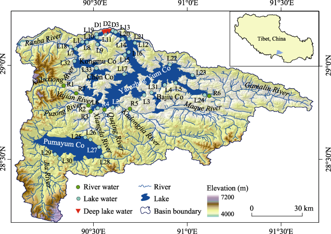
Figure 1 Map of the YYB and sampling locations. It is based on the digital elevation model (DEM) with a ground resolution of 90 m, which was obtained from the NASA SRTM (http://srtm.csi.cgiar.org/)
Major lakes in the YYB include Lake Yamzhog Yum Co, Kongmu Co, Chen Co, Bajiu Co, and Puma Yum Co. As one of the holy lakes in Tibet, Lake Yamzhog Yum Co (90°22′- 91°03′E, 28°27′-29°12′N) is the largest inland lake on the northern foothills of the Himalayas with a water surface of about 588.9 km2 (Sun et al., 2013a). Supplied mainly by precipitation, the lake level has dropped significantly since 1974 (Ye et al., 2007; Chu et al., 2012; Li, 2014). There are 7 major inflowing rivers around the lake, i.e., Gamalin River, Kadongjia River, Quqing River, Xiangda River, Puzong River, Kaluxiong River, and Yajian River (Figure 1). Located about 40 km southward from Lake Yamzhog Yum Co, Lake Puma Yum Co (90°13′-91°33′E, 28°30′-28°38′N) is the second largest lake in this basin with an area of about 285.7 km2 (Tian et al., 2012). The Jia River, accounting for 77% of the total inflow into the Lake Puma Yum Co, is sourced from the glacial melt in the southwestern part of the basin (Zhu et al., 2006). An open channel connected to the Kadongjia River was excavated on the lake’s eastern side, through which the water drained into Lake Yamzhog Yum Co during high lake level period.

2.2 Sampling and testing

Water samples were field collected annually in the YYB from 2009 to 2014. A total of 52 sampling sites were set in this basin (Figure 1), comprising 24 surface water sites and 12 deep water sites (0.5 m, 10 m, 20 m, and 30 m, respectively, beneath the water surface along 3 profiles) in Lake Yamzhog Yum Co, 6 surface water sites in Lake Puma Yum Co, and 10 surface water sites in other 3 lakes and 7 rivers. According to the coordinates of global positioning system (GPS, Trimble Juno SB, USA) and field investigation records, sampling sites were kept as consistent as possible. In addition, historical observation data in 1979 and 1984 were extracted trying to give a whole picture of the hydrochemical evolution in the YYB during the past dacades.
All the water samples were collected using pre-washed high-density polyethylene (HDPE) bottles wrapped with parafilm immediately after sample collection. Parameters including water temperature (T), pH, and total dissolved solids (TDS) were measured in situ by utilizing a multi-parameter water probe sensor (HANNA HI9828, Italy). While hydrochemical ions were tested in the laboratory at the Institute of Geographic Sciences and Natural Resources Research (IGSNRR), Chinese Academy of Sciences (CAS), the cations of K+, Na+, Ca2+, and Mg2+ were measured by an inductively coupled plasma optical emission spectrometer (ICP-OES, Perkin-Elmer Optima 5300DV, USA) with a precision of ±5%. An ion chromatography system (ICS, Shimadzu LC-10ADvp, Japan) with the accuracy about ±0.04% was adopted for the analysis of Cl- and SO42-. CO32- and HCO3- were titrated by double-indicator method. Mineralization degree (MD) was summed up by all major ions. And total hardness (TH) was calculated with the following equation (Maidment, 1993):
TH (mg/l as CaCO3) = 2.497×Ca (mg/l) + 4.118×Mg (mg/l)

2.3 Analysis method

Plotted by GW-Chart (Winston, 2000), Piper trilinear diagram (Piper, 1944) was used for elucidating the dominant ions and hydrochemical types of waters in the YYB. Distinct zones in Piper diagram display different hydrochemical facies with defined cation and anion concentrations (Cui and Li, 2014). Based on Kriging interpolation method (Stein, 1999), the contour maps of hydrochemical concentrations were drawn in ArcGIS 10.2 (ESRI, 2013) to describe the spatial variation of hydrochemical features. Meanwhile, Gibbs model (Gibbs, 1970) was introduced to reveal the natural control mechanism of hydrochemistry, namely, the influences of precipitation, rock-water interaction, and evaporation on dissolved salts in waters.

3 Results and discussion

Based on the annual average hydrochemical data for waters in the YYB during 2009-2014, the cationic charge (TZ+ = Na++K++2Mg2++2Ca2+) ranged from 5.21 to 68.28 meq/l with the average of 33.76 meq/l, and anionic charge (TZ- = Cl-+2SO42-+HCO3-+NO3-) varied from 3.36 to 63.91 meq/l with an average of 27.83 meq/l (Table 1). The normalized inorganic charge balance (NICB = (TZ+-TZ-)/TZ+) of all samples were about 0.18, indicating the reliability of the data (Xiao et al., 2012b).

3.1 Physicochemical parameters

Waters in the YYB were weakly alkaline, with pH values ranging from 8.38 to 9.49 (Table 1; Figure 2a). Most waters exceeded the permitted pH values for drinking (6.5-8.5) stipulated by Chinese Ministry of Environmental Protection (2002). As the TH values of the Yajian River and Gamalin River were 127.32 and 174.68, respectively, they were classified as hard waters (121 < TH < 180 mg/l; Maidment, 1993). All other waters in the YYB were the hardest water (TH > 180 mg/l), with TH values ranging from 207.05 to 1327.68 mg/l (Table 1 and Figure 2b). Specifically, the TH values of Lake Bajiu Co and Yamzhog Yum Co were higher than the recommended value of the World Health Organization (WHO) for drinking water (500 mg/l). In addition, the lakes were slightly saline (TDS > 1000 mg/l; Maidment, 1993), with the TDS reaching 1550.67 and 1065.71 mg/l in Lake Bajiu Co and Yamzhog Yum Co, respectively (Table 1; Figure 2c). Most other waters were fresh (TDS < 1000 mg/l). In particular, the relatively low TDS values of Lake Kongmu Co (209.33 mg/l) and Puma Yum Co (227.69 mg/l) were indicative of diluting effects of glacial melt on soluble salts in water, resulting from the inflow of the Kaluxiong River and Jia River, respectively. Compared with the lakes, the rivers contained lower TDS, ranging from 110.50 to 269.17 mg/l, which probably be ascribed to lower flow velocity at the river mouth, or a higher rate of evaporation in the lakes compared with the rivers. Almost all rivers in the YYB, however, contained higher TDS than the mean value of the world’s rivers (115 mg/l; Gaillardet et al., 1999), which could be attributed to intense evaporation over the TP.
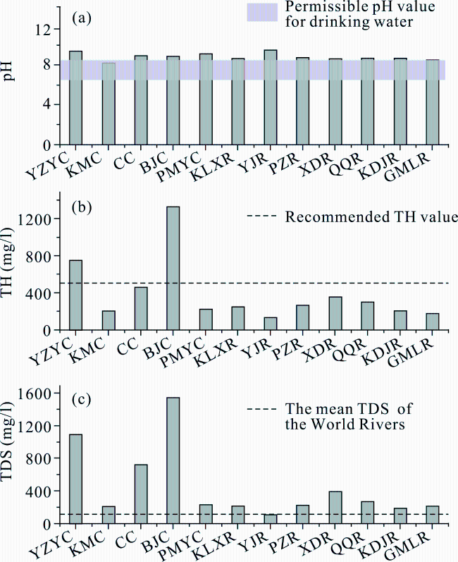
Figure 2 The annual average (a) pH, (b) TH, and (c) TDS values of waters in the YYB during 2009-2014. YZYC, KMC, CC, BJC, PMYC, KLXR, YJR, PZR, XDR, QQR, KDJR, and GMLR are short for Lake Yamzhog Yum Co, Kongmu Co, Chen Co, Bajiu Co, Puma Yum Co, Kaluxiong River, Yajian River, Puzong River, Xiangda River, Quqing River, Kadongjia River, and Gamalin River, respectively

3.2 Hydrochemical regime

(1) For the Yamzhog Yumco Basin (YYB)
Diversified hydrochemical types with various dominant ions were obtained in the waters of the YYB (Figure 3). Mg2+ and Na+ constituted the major cations, and SO42- plus HCO3- made up the major anions for waters in Lake Yamzhog Yum Co (Figure 3a), indicating its SO42--HCO3--Mg2+-Na+ type. The hydrochemical types of Lake Bajiu Co, Kongmu Co, Chen Co, and Puma Yum Co were SO42--Mg2+-Na+, SO42--HCO3--Ca2+, SO42--Na+-Mg2+-Ca2+, and HCO3--SO42--Mg2+-Ca2+, respectively. While for the inflowing rivers, the hydrochemical types were HCO3--Ca2+ and SO42--Ca2+ with Ca2+ concentrations accounting for more than 57% of the cations (Figure 3b), which were particularly different from that in Lake Yamzhog Yum Co and Bajiu Co. The lower Ca2+ concentrations in lakes should be related to the intense evaporation and subsequent precipitation of Ca2+ from the lake waters in the form of carbonate (Zhu et al., 2010b).
The weathering of rock material also contributes to the hydrochemical composition of water, and this contribution can be estimated from carbonate hardness, represented by the concentrations of Mg2+ and Ca2+ in the water, as carbonate hardness is in equilibrium with dissolved carbonates (Li et al., 2013). For the waters of Lake Puma Yum Co, Gamalin River, and Yajian River, the predominant impact factors were weathered carbonates with their carbonate hardness exceeding 50% distributed in Zone I in Piper diagram (Figure 3). While weathered evaporates were dominating factors with non-carbonate hardness exceeding 50% for the waters of Lake Bajiu Co, Kadongjia River, Quqing River, and Puzong River located in Zone II. Weak water-rock interactions were detected in Lake Yamzhog Yum Co, Kongmu Co, and Chen Co, in view of their samples situated in Zone V with no anion-cation pair exceeding 50% (Figure 3).
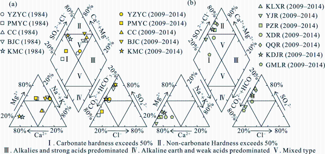
Figure 3 The Piper diagrams of the major ion concentrations and hydrochemical types of waters in the YYB, showing (a) the current status (2009-2014) and the variations from 1984 in lake waters and (b) the current status (2009-2014) in river waters. Data in 1984 is after Chen (1990). YZYC, PMYC, CC, BJC, KMC, KLXR, YJR, PZR, XDR, QQR, KDJR, and GMLR are short for Lake Yamzhog Yum Co, Puma Yum Co, Chen Co, Bajiu Co, Kongmu Co, Kaluxiong River, Yajian River, Puzong River, Xiangda River, Quqing River, Kadongjia River, and Gamalin River, respectively
(2) For the Lake Yamzhog Yum Co
The complex zigzag shoreline of Lake Yamzhog Yum Co, coupled with mixed inflow from various river systems, had resulted in inhomogeneous mixing of the waters, giving rise to significant spatial differences in the hydrochemistry of its surface waters. The MD values, as well as the molar concentrations of (Na++K+) and Mg2+, were low in the river mouth entering into Lake Yamzhog Yum Co (Figures 4a-4c). Obviously, inflowing river water played an essential role as a diluting agent. Moreover, the narrow shape and steep northwestern lakeshore made slope runoff an important factor contributing to the low MD values in this region (Figure 4a). In contrast, higher Ca2+ molar concentrations occurred proximal to river mouths, due to the high Ca2+ values of the inflowing river waters (Figure 4d). While pervasively low Ca2+ concentrations were maintained throughout Lake Yamzhog Yum Co because of the large amount of Ca2+ precipitated in carbonates during periods of intense evaporation and concentration. These hydrochemical characteristics are similar to those of most alpine lakes on or near the TP (Ju et al., 2010). The concentrations of Cl-, SO42-, and (HCO3-+ CO32-) ranged among 7.78%-8.18%, 52.20%-53.71%, and 38.19%-39.98%, respectively.
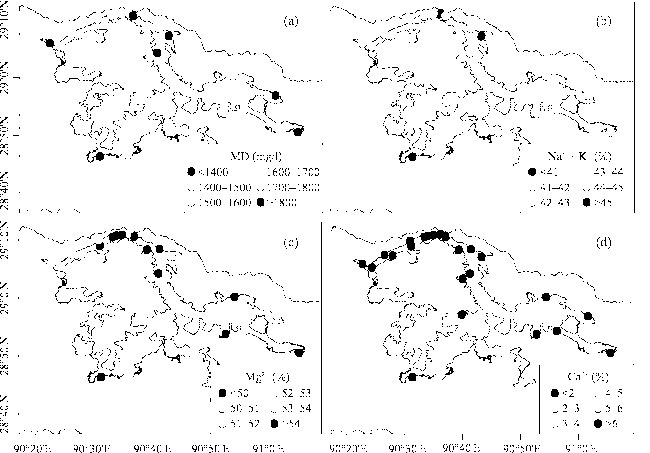
Figure 4 The spatial distribution of (a) MD values and the molar concentration percentage of (b) (Na++K+), (c) Mg2+, and (d) Ca2+ in the surface water of Lake Yamzhog Yum Co
The irregularity of hydrochemical variations with depth (Figure 5) was related to disturbances caused by strong winds over the TP, and abundant rainfall during the sampling period. Additionally, the warming climate accelerated glacial melt, resulting in less pronounced variations with water depth during 2009-2014 than was observed in 1979. In summary, waters in Lake Yamzhog Yum Co were mixed uniformly in the vertical direction, which was in agreement with the previous studies about the water spatial variation based on stable isotopes (Zang et al., 2014).
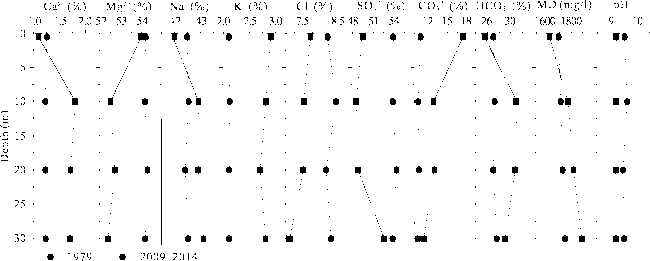
Figure 5 The vertical changes in major ions, MD, and pH values of waters in Lake Yamzhog Yum Co in 1979 and 2009-2014. Data in 1979 is after Guan et al. (1984)

3.3 Mechanisms controlling hydrochemistry

Ion source and climatic change were the two primary impact factors of the hydrochemical characteristics.
(1) Source of ions
The source of hydrochemical ions was explored through a Gibbs diagram (Figure 6). Water samples from Lake Yamzhog Yum Co, Chen Co, and Bajiu Co contained relatively high TDS and yielded high Na+/(Na++Ca2+) values, plotting in the evaporation-crystallization zone in Figure 6. The influence of weathered rock material introduced to the lakes by inflowing rivers was likely the cause of the low Cl-/(Cl-+HCO3-) values, as shown by samples from Lake Kongmu Co and seven rivers, which plotted in the rock dominance zone (low TDS; Figure 6). Similar position was observed for the samples from Lake Puma Yum Co in the Gibbs diagram. Higher Na+/(Na++Ca2+) ratios, however, reflected the combined effects of evaporation and crystallization.
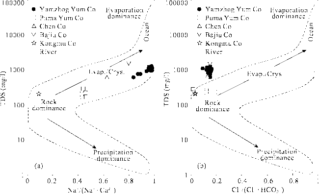
Figure 6 Gibbs diagram of TDS values versus the weight ratio of Na+/(Na++Ca2+) and Cl-/(Cl-+HCO3-), indicating the mechanisms controlling the hydrochemistry of main lake and river waters in the YYB
As noticeable effects on the hydrochemical compositions of lake waters in the YYB, the source of ions in river waters was further analyzed. Weathered rocks are the major source of dissolved salts in river waters due to limited precipitation and waste pollution in this region (Smolders et al., 2004). 50% of solutes in the world’s rivers originate from carbonates, 17.2% from evaporates, and 11.6% from silicates (Meybeck, 1987). The rock types that have been weathered to yield the solutes can be determined from the major ions in the waters, e.g., HCO3- in river waters is derived mainly from the weathered carbonates, Cl- and SO42- from evaporates, Na+ and K+ from both evaporates and silicates, and Ca2+ and Mg2+ may from all three of these rock types under natural conditions (Chen et al., 2002). The types of weathered rock affecting the hydrochemistry of rivers in the YYB hence were uncovered by analyzing the ratios of major ions in waters (Figure 7). Considering the relatively high concentrations of (Cl-+SO42-) compared with HCO3-, solutes in the waters of Xiangda River, Quqing River, Kaluxiong River, Puzong River, and Kadongjia River were derived from weathered evaporates where they flowed above (Figure 7a). Conversely, the high HCO3- concentrations in the waters of Gamalin River and Yajian River indicated that ions in these waters were derived predominantly from the weathering of carbonates. Weathered evaporates constituted a source of solutes in Yajian River, which contained almost equal proportions of (Cl-+SO42-) and HCO3-. In addition, all the rivers contained almost equal proportions of (HCO3-+SO42-) and (Ca2++Mg2+) (Figure 7b), indicating that the dissolution of calcite, dolomite and gypsum could be crucial reaction in river systems. Relatively high (Ca2++Mg2+) values revealed weathered carbonates were not the primary source of ions in the river systems (Figure 7c), and additional sources of Ca2+ and Mg2+ were balanced by Cl- and SO42- (Zhang et al., 2011). The greater proportion of (Ca2++Mg2+) and SO42- relative to alkalis metal ions (Figure 7d) and Na+ (Figure 7e) , respectively, were indicative of the influence of Ca2+-Mg2+-SO42--rich rocks (e.g., gypsum) on the hydrochemistry of river waters. The relationship between SO42- and Na+ suggested mirabilite was a potential source of Na+ in Gamalin River owing to the coordinate relationship between SO42- and Na+ (Figure 7f). And halite was responsible for Na+ in Puzong River, Kaluxiong River, Quqing River, and Kadongjia River, because they contained equal proportions of Na+ and Cl- (Figure 7f). Na+ in Xiangda River was probably originated from silicates, as no correlation between SO42-, Cl-, and other metal ions is observed.
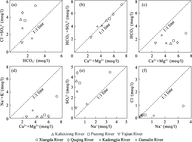
Figure 7 Scatter diagrams of (a) (Cl-+SO42-) vs. HCO3-, (b) (HCO3-+SO42-) vs. (Ca2++Mg2+), (c) HCO3- vs. (Ca2++Mg2+), (d) (Na++K+) vs. (Ca2++Mg2+), (e) SO42- vs. Na+, and (f) Cl- vs. Na+ for river waters in the YYB
(2) Climatic change
Climatic change contributes to hydrochemical variations in the YYB, particularly in Lake Puma Yum Co. The annual average temperature and annual precipitation increased at a rate of 0.4°C/10a and 22.1 mm/10a, respectively, between 1984 and 2014. Compared with field hydrochemical investigations in 1984 (Chen, 1990), the salinity of Lake Puma Yum Co for the period of 2009-2014 had been decreased obviously (Zone I in Figure 3a), which should be a result of accelerated glacial melt driven by a warming climate. While both ionic compositions and hydrochemical types had changed little in the other waters of the YYB (Figure 3a), which can be explained with water balance of the closed lake system. Specifically, inflow runoff and lake-surface precipitation were the major inputs, lake evaporation was the major output, and water leakage and inaccuracy were the residuals. Sun et al., (2014) reported that variations in the water volume of Lake Yamzhog Yum Co showed no clear relationship with system outputs, but strongly correlated with inputs, including increased precipitation and melting water. In addition, underground water leakage and the operation of the Yanzhog Yumcuo Pumped Storage Power Station probably exacerbated water loss. Therefore, although evaporation was greatly enhanced under the climatic warming, little change was detected in the hydrochemical properties of the closed lake system of the YYB. To better identify the influences of climatic change on the hydrochemical regime and its mechanism of alpine lakes, more regular water sampling should be conducted at a higher spatial resolution. Moreover, future studies should focus on quantifying each component of the lake water balance.

4 Conclusions

Based on the long-term and large-scale field investigation, we analyzed the hydrochemical characteristics of waters in the YYB, shedding light on the hydrochemical regime and its mechanism. This research gave a whole picture of hydrochemical status in the YYB for the first time.
(1) Waters of the YYB were unsuitable for drinking due to their excessive hardness (TH>500 mg/l) and alkalinity (pH>8.5). Most of the rivers in the basin contained higher TDS than the mean value of the world’s rivers, owing to intense evaporation over the TP.
(2) Apparent differences existed in dominant ions and hydrochemical types among the waters of the YYB, most notably the much lower Ca2+ concentration in Lake Yamzhog Yum Co than that in its inflowing rivers. The loss of Ca2+ in lake could be attributed to the carbonate precipitation induced by intense evaporation. Lake Yamzhog Yum Co exhibited remarkable spatial variations in MD and the concentrations of cations for its surface waters but irregular changes in the vertical direction.
(3) The dominant mechanisms controlling the hydrochemistry of the YYB included the weathering of evaporates and carbonates and climatic change. In particular, Lake Puma Yum Co experienced marked desalination between 2009 and 2014, resulting from accelerated glacial melt induced by the dramatic warming over the TP.

The authors have declared that no competing interests exist.

[1]
Bianduo, Bianbaciren, Li Let al., 2009. The response of lake change to climate fluctuation in north Qinghai-Tibet Plateau in last 30 years.Journal of Geographical Sciences, 19(2): 131-142.According to the analysis of the climate materials including the topographic map in 1975, the TM and CBERS satellite remote sensing materials from the 1980s to 2005 as well as the air temperature, precipitation, evaporation rate, maximum depth of snow and the biggest depth of frozen soil in the past 45 years, the water level area of four lakes at the southeast of Nagqu, Tibet including Bam Co, Pung Co, Dung Co and Nuripung Co show a distinct trend of expansion in the past 30 years. In 2005, the water level area of the above four lakes increased by 48.2 km2, 38.2 km2, 19.8 km2 and 26.0 km2 respectively compared to 1975, with the respective increase rate of 25.6%, 28.2%, 16.2% and 37.6%. That is closely related to the warming and humidified climate change in the recent years such as rise of the air temperature, increase of the precipitation, decrease of the evaporation rate and permafrost degradation.

DOI

[2]
Chen J S, Wang F Y, Xia X Het al., 2002. Major element chemistry of the Changjiang (Yangtze River).Chemical Geology, 187(3): 231-255.The chemistry of major elements (Ca, Mg, Na, K, HCO 3 , SO 4 , Cl, and Si) in the river water of the Changjiang (Yangtze River) was studied, based on continuously monitored data at 191 stations in the drainage basin for the period 1958–1990. The results show that the total dissolved solid (TDS) concentration of the Changjiang varies over an order of magnitude throughout the basin (49.7–518.1 mg/l), with a medium TDS concentration of 205.9 mg/l, about three times the global average. In contrast, the TDS at a given main-channel station varies only slightly in different seasons with a variation factor less than 2.0, despite a substantial water dilution in the summer flood season. The major element chemistry of the Changjiang is mainly controlled by rock weathering, with the anion HCO 3 and the cation Ca dominating the major ion composition, due to the abundance of carbonate rocks in the basin. A persistently increasing trend has been observed in the concentrations of SO 4 and, to a lesser extent, Cl in the Changjiang, a signature of considerable anthropogenic impacts (e.g., acid deposition). Flux calculations at Datong (the most downstream main-channel station without tidal influence) indicate that the Changjiang transports ca. 154×10 6 tons/year of TDS to the sea, second only to the Amazon in the world.

DOI

[3]
Chen X P, 1990. On the change of water environment in Yangzhuoyong Lake, Tibet.Oceanologia et Limnologia Sinica, 21(3): 285-293. (in Chinese)The Yangzhuoyong Lake, a big enclosed type lake in Tibet, has a water capacity of 14300 million m3. The amount of water entered the lake equals basically to that evaporated and the water level is relatively stable. The mineralization of the lake water is about 1 900 mg/L now. The lake water can be exploited for generating electricity by using the potential energy of water level between Yangzhuoyong Lake and Yarluzangbu River. In this paper, the changes of the water capacity and mineralization after exploiting the lake water resource are calculated quantitatively with the balance equation of water capacity and zero-dimensional model of water quality. The result shows that the change of mineralization is not remarkable, but the lake area will decrease 121.4 km3 after 67 years. So the water entered the lake is 181 million m3 more than the water evaported each year. These surplus water can be used for generating electricity. The water will gradually desalinate and the mineralization will tend to equilibrium concentration after 700 years. If the lake is not exploited, the water quality will be continually saltified.

[4]
Chu D, Pu Qiong, Labazhuomaet al., 2012. Remote sensing analysis on lake area variations of Yamzho Yumco in Tibetan Plateau over the past 40a.Journal of Lake Sciences, 24(3): 494-502. (in Chinese)

[5]
Cui B L, Li X Y, 2014. Characteristics of stable isotopes and hydrochemistry of river water in the Qinghai Lake Basin, northeast Qinghai-Tibet Plateau, China.Environmental Earth Sciences, 73(8): 4251-4263.The integrated use of isotopic and hydrochemical tracers is an effective way to investigate hydrological processes on a range of spatial and temporal scales. This study investigated stable isotopes and hydrochemistry of the river water in the Qinghai Lake Basin, and discussed relationships between runoff and variations of air temperature and precipitation. Results indicated that all of the river water points lie close to the local meteoric water line (LMWL); and the slope of local evaporation line of river water samples (6.82) was smaller than that of the LMWL (7.98), indicating that the river water mainly originated from the precipitation in the catchments which underwent weak evaporation. The river water in the tributaries would undergo relatively stronger evaporation than that in the main stream. The hydrochemical type of river water was Ca-揗g-揌CO 3 , and the river water chemistry was mainly controlled by carbonate dissolution in the Qinghai Lake Basin. The river discharge was generated mainly from the middle and upper catchment. The runoff depths of Buha River Catchment and Shaliu River Catchment were 91.0mm and 283.4mm, respectively; and the runoff coefficients were 0.164 and 0.531, respectively. Because of a relatively longer channel, larger drainage area and smaller gradient, the surface water flowed more slowly and infiltrated more in the large river catchment; therefore, the runoff coefficient in the large river catchment was smaller than that in the relatively smaller catchment. The river runoff in the Qinghai Lake Basin was primarily influenced by precipitation. This study provides insights into the hydrological and geochemical processes of cold and alpine rivers, along with water resource management options in the Qinghai Lake Basin and northeast Qinghai-Tibet Plateau.

DOI

[6]
Du J, Hu J, Tang S Jet al., 2008. Climatic variations of temperature and precipitation in the Yamzho Yumco Lake Basin of Tibet from 1961 to 2005.Acta Geographica Sinica, 63(11): 1160-1168. (in Chinese)The interannual, interdecadal variations and anomalous years of the annual and seasonal mean temperature and precipitation are investigated in the context of the monthly data at 9 meteorological and hydrological stations in the Yamzho Yumco Lake basin of Tibet from 1961 to 2005 by using modern statistical diagnostic methods such as the linear trend, and the relationship between lake level and precipitation is discussed. The results show that the annual temperature presented a significant increasing trend and the rate of increase is about 0.25 oC/10a during recent 46 years, indicating that the warming trend is obvious in autumn and winter. In recent 25 years (1981-2005), the precipitation presents a decreasing trend in winter, while the increasing trend is apparent in other seasons with a rate of (11.4-30.0) mm/10a, especially in summer. Finally, the annual precipitation shows an obviously increasing trend and the rate is 54.2 mm/10a. In terms of interdecadal variations, the mean temperature increases apparently in most seasons, except in summer. The summer precipitation is less in the 1980s, more in the other three decades. On the contrary, in winter the precipitation is more in the 1980s, less in the other three decades. Also, the warm anomalous years of annual mean temperature occurred three times in the end of the 1990s and the early 2100s. The more precipitation anomalous years occurred in the end of the 1960s and the early 1970s. Since generation of electricity with the water of the Yamzho Yumco Lake in 1997, the trend of annual precipitation has increased. The mean precipitation is about 409.7 mm in the basin, which is higher than the balanced rainfall, and presents an obvious increasing trend of the lake level. The water level rise is directly correlated with precipitation increase and sunshine decrease, while the apparent rise of temperature and the increase of snowmelt are also important factors.

[7]
ESRI, 2013. ArcGIS Desktop: Release 10.2.

[8]
Gaillardet J, DupréB, Louvat Pet al., 1999. Global silicate weathering and CO2 consumption rates deduced from the chemistry of large rivers.Chemical Geology, 159(1-4): 3-30.The main problem associated with the study of silicate weathering using river dissolved load is that the main control of solute chemistry is lithology and that all rivers are influenced by carbonate and evaporite weathering. In this paper, newly compiled data on the 60 largest rivers of the world are used to calculate the contribution of main lithologies, rain and atmosphere to river dissolved loads. Technically, an inverse method is used to solve a model containing of a series of mass budget equations relating river concentrations to chemical weathering products and atmospheric inputs. New estimates of global silicate weathering fluxes and associated CO 2 consumption fluxes are given. The role of basalt weathering on oceanic islands and volcanic arcs is emphasized. For each large river, an attempt is made to calculate chemical weathering rates of silicates per unit area. Only relative chemical weathering rates can be calculated. The relationships between the chemical weathering rates of silicates and the possible controlling parameters are explored. A combined effect of runoff-temperature and physical denudation seems to explain the variability of modern silicate chemical weathering rates. The results of this study highlight the coupling between the physical and the chemical processes of silicate weathering. Only an active physical denudation of continental rocks seems to be able to maintain high chemical weathering rates and significant CO 2 consumption rates.

DOI

[9]
Gibbs R J, 1970. Mechanisms controlling world water chemistry. Science, 170(3962): 1088-1090.

[10]
Guan Z, Chen C, Qu Y et al., 1984. Rivers and Lakes in Tibet. Beijing: Science and Technology Press. (in Chinese)

[11]
Huang L, Liu J Y, Shao Q Qet al., 2011. Changing inland lakes responding to climate warming in Northeastern Tibetan Plateau.Climatic Change, 109(3): 479-502.The main portion of Tibetan Plateau has experienced statistically significant warming over the past 5002years, especially in cold seasons. This paper aims to identify and characterize the dynamics of inland lakes that located in the hinterland of Tibetan Plateau responding to climate change. We compared satellite imageries in late 1970s and early 1990s with recent to inventory and track changes in lakes after three decades of rising temperatures in the region. It showed warm and dry trend in climate with significant accelerated increasing annual mean temperature over the last 3002years, however, decreasing periodically annual precipitation and no obvious trend in potential evapotranspiration during the same period. Our analysis indicated widespread declines in inland lake’s abundance and area in the whole origin of the Yellow River and southeastern origin of the Yangtze River. In contrast, the western and northern origin of the Yangtze River revealed completely reverse change. The regional lake surface area decreased by 11,49902ha or 1.72% from the late 1970s to the early 1990s, and increased by 6,86602ha or 1.04% from the early 1990s to 2004. Shrinking inland lakes may become a common feature in the discontinuous permafrost regions as a consequence of warming climate and thawing permafrost. Furthermore, obvious expanding were found in continuous permafrost regions due to climate warming and glacier retreating. The results may provide information for the scientific recognition of the responding events to the climate change recorded by the inland lakes.

DOI

[12]
Immerzeel W W, van Beek L P H, Bierkens M F P, 2010. Climate change will affect the Asian water towers.Science, 328(5984): 1382-1385.More than 1.4 billion people depend on water from the Indus, Ganges, Brahmaputra, Yangtze, and Yellow rivers. Upstream snow and ice reserves of these basins, important in sustaining seasonal water availability, are likely to be affected substantially by climate change, but to what extent is yet unclear. Here, we show that meltwater is extremely important in the Indus basin and important for the Brahmaputra basin, but plays only a modest role for the Ganges, Yangtze, and Yellow rivers. A huge difference also exists between basins in the extent to which climate change is predicted to affect water availability and food security. The Brahmaputra and Indus basins are most susceptible to reductions of flow, threatening the food security of an estimated 60 million people.

DOI PMID

[13]
Jiang L G, Yao Z J, Liu Z Fet al., 2015. Hydrochemistry and its controlling factors of rivers in the source region of the Yangtze River on the Tibetan Plateau.Journal of Geochemical Exploration, 155: 76-83.This study focuses on the chemical composition, and the factors controlling it, of the high mountain-rivers in the source region of the Yangtze River on the Tibetan Plateau. By comprehensive and systematic analysis, the chemical signatures, spatial variations of water quality, as well as the factors controlling them are studied. The value of the average total dissolved solids (TDS) is 77802mg/l, ranging from 117 to 549602mg/l. In order of decreasing concentration, the main cations are Na + , Ca 202+ , Mg 202+ , and K + , while the main anions are Cl 61 , HCO 3 61 , SO 4 20261 , and NO 3 61 . Na + and Cl 61 are the dominant ions, accounting for 74.2% and 63.7% of the total cations and anions, respectively, followed by Ca 202+ and HCO 3 61 , which account for 14.3% and 25%, respectively. The Piper diagram shows the main water type to be a Cl 61 ·HCO 3 61 –Na + ·Ca 202+ type. From the Gibbs boomerang model, we conclude that the chemistry of the river water is controlled by lithogenic weathering processes. The Na-normalized ratio end-member diagram indicates that the weathering of silicates and carbonates is relatively significant, on the whole. There exists pronounced regional heterogeneity in the water chemistry and the factors affecting it. The northern rivers, including Chumaer He, Beilu He, and Ranchiqu, are mainly affected by evaporation and crystallization processes, while the southern rivers (Tuotuo He, Gaerqu, and Buqu) show effects from the weathering of carbonates and silicates.

DOI

[14]
Ju J T, Zhu L P, Wang J Bet al., 2010. Water and sediment chemistry of Lake Pumayum Co, South Tibet, China: Implications for interpreting sediment carbonate.Journal of Paleolimnology, 43(3): 463-474.A combination of water and sediment chemistry was used to investigate carbonate production and preservation in Lake Pumayum Co (altitude 5,030&nbsp;m&nbsp;a.s.l.), south Tibet, China. We compared the chemical composition of lake water in various parts of the lake with that of input rivers and found that the loss of Ca2+ results from calcite sedimentation induced by evaporation and biogenic precipitation. This is supported by evaporation data from the catchment and δ18O measurements on water. Results suggest that CaCO<sub>3</sub> is the predominant carbonate in this lake. There is a positive correlation in the sediments among concentrations of total inorganic carbon (TIC), Ca, total organic carbon (TOC), and total nitrogen, confirming that most carbonates in sediment are endogenic. The Jiaqu River is the largest inflow to Lake Pumayum Co and has a strong influence on both lake water chemistry and sediment composition. The river and lake bathymetry influence carbonate sedimentation by affecting water flow velocity and growing conditions for macrophytes. Different carbon contents and relationships between TIC and TOC in the two long cores from different depths in the lake reveal that hypolimnetic conditions also influence carbonate precipitation and preservation.

DOI

[15]
Kang S C, Xu Y W, You Q Let al., 2010. Review of climate and cryospheric change in the Tibetan Plateau.Environmental Research Letters, 5(1): 75-82.

[16]
Lerman A, Imboden D, Gat J, 1995. Physics and Chemistry of Lakes. New York: Springer.

[17]
Li P Y, Qian H, Wu J Het al., 2013. Major ion chemistry of shallow groundwater in the Dongsheng Coalfield, Ordos Basin, China.Mine Water and the Environment, 32(3): 195-206.A hydrogeochemical study was conducted in the Dongsheng Coalfield, Ordos Basin, China, to identify the mechanisms responsible for the chemical compositions of the shallow groundwater and to document water quality with respect to agricultural and drinking supply standards, prior to mining. Tri-linear diagrams, principal component analysis, and correlation analysis were used to reveal the hydrogeochemical characteristics of the shallow groundwater, and the potential water-rock interactions. In general, the major cations and anions were present at low concentrations, but were relatively higher around Jiushenggong than elsewhere in the study area. Groundwater around Jiushenggong has a long residence time and is also subject to extensive evapotranspiration. The dominant hydrochemical facies are HCO3-Ca, HCO3-Na, and mixed HCO3-Ca center dot Na center dot Mg types. Increases in major ion concentrations along the flow path, including Na, Cl, and SO4, coincide with increases in total dissolved solids. The predominant mechanism controlling groundwater chemistry proved to be the dissolution of carbonates, gypsum, and halite. Cation exchange and mixing with local recharge water are also important factors. The shallow groundwater quality in the study area is suitable for agricultural and drinking purposes.

DOI

[18]
Li Z G, 2014. Glacier and lake changes across the Tibetan Plateau during the past 50 years of climate change. Journal of Resources and Ecology, 5(2): 123-131.In this paper, recent glacier and lake changes research on the Tibetan Plateau was reviewed. Emphasis was placed on a discussion of the relationship between glacier shrinkage and lake change. In the context of global climate change, the glaciers of the Tibetan Plateau have generally retreated, while the lakes have generally expanded. First, the research on glacial terminal retreat, glacial area and volume variations across the Tibetan Plateau over the last few decades are reviewed and analyzed; the temporal-spatial change characteristics of the glaciers are discussed. Secondly, the lake area, volume and water level changes are reviewed and analyzed; the temporal-spatial change characteristics of the glaciers are discussed. The results indicate that the retreat speed in the outer edge of the Tibean Plateau was overall faster than that in the inland area. The areas and water levels of the lakes that are fed by glacial water increased. Finally, the limitations of the present studies and future work are discussed.

DOI

[19]
Maidment D R, 1993. Handbook of Hydrology. New York: McGraw-Hill.

[20]
Meybeck M, 1987. Global chemical weathering of surficial rocks estimated from river dissolved loads.American Journal of Science, 287(5): 401-428.ABSTRACT. Combination of water analyses characteristic of major rock types with their relative outcrop proportions at the surface of the continents leads to a theoretical average composition of river waters close to the actual measured value. The representative anal-

DOI

[21]
Ministry of Environmental Protection, 2002. Environmental Quality Standard for Surface Water, GB 3838-2002. Beijing.

[22]
Piper A M, 1944. A graphic procedure in the geochemical interpretation of water analyses. Eos,Transactions American Geophysical Union, 25(6): 914-923.This paper outlines certain fundamental principles in a graphic procedure which appears to be an effective tool in segregating analytical data for critical study with respect to sources of the dissolved constituents in waters, modifications in the character of a water as it passes through an area, and related geochemical problems. The procedure is based on a multiple-trilinear diagram (Fig. 1) whose form has been evolved gradually and independently by the writer during the past several years through trial and modification of less comprehensive antecedent forms. Neither the diagram nor the procedure here described is a panacea for the easy solution of all geochemical problems. Many problems of interpretation can be answered only by intensive study of critical analytical data by other methods.

DOI

[23]
Shi W G, 1995. Impact of yangzhuoyong lake hydropower on ecological environment in Tibet.Journal of Lake Sciences, 7(2): 178-184. (in Chinese)After a careful study on background, the change of mineralization degree in the lake was determined. The results sumulated show that the water of the lake, with a mineralization degree of 1900 mg/L , will be unlikely changed into fresh water even after more than 100-year power station running. There are 53 genera of phytoplankton and 42 genera of zooplankton in the lake, characterized by species diversity and the lack of biomass as other oligotrophic lakes. It is predicted that the change of water temperature and nutrient is not great, so the impact on the characteristics of plankton and fish can be negligible. After developing the power station, the impact on terrestrial ecosystem is expected to be not great. But the temperature in summer will increase by 0.2~0.4鈩,a benefit to some crops. Besides, the new beach abandoned by water is favourable for the development of stock-raising and agricuture. Finally, the remedial measures for ecological environment have been devised in case unfavourable impact occurs.

DOI

[24]
Smolders A J P, Hudson-Edwards K A, Van der Velde Get al., 2004. Controls on water chemistry of the Pilcomayo river (Bolivia, South-America).Applied Geochemistry, 19(11): 1745-1758.lt;h2 class="secHeading" id="section_abstract">Abstract</h2><p id="">In order to reveal the intra-annual variability of the major ion composition of the Pilcomayo river, a dryland river, and its relationship to discharge, water samples were taken at regular time intervals from May 1998 until February 1999 at the town of Villa Montes (Bolivia). Water chemistry of the Pilcomayo river was highly variable during the year and strongly influenced by differences in discharge between the wet and the dry season. Halite dissolution appeared to play an important role and both Cl and Na concentrations became very high (&plusmn;10 mmol L&minus;1) during the dry season. Pyrite weathering and dissolution of gypsum, dolomite and calcite determined Ca, Mg, CO<sub>3</sub> and SO<sub>4</sub> chemistry. At the onset of the rainy season `rinse out' effects occurred, resulting in marked concentration peaks especially for the least soluble ions. Possible effects on biota, such as consequences for trace metal toxicity, are discussed briefly.

DOI

[25]
Song C Q, Huang B, Ke L Het al., 2014a. Remote sensing of alpine lake water environment changes on the Tibetan Plateau and surroundings: A review.ISPRS Journal of Photogrammetry and Remote Sensing, 92(2): 26-37.Alpine lakes on the Tibetan Plateau (TP) are key indicators of climate change and climate variability. The increasing availability of remote sensing techniques with appropriate spatiotemporal resolutions, broad coverage and low costs allows for effective monitoring lake changes on the TP and surroundings and understanding climate change impacts, particularly in remote and inaccessible areas where there are lack of in situ observations. This paper firstly introduces characteristics of Tibetan lakes, and outlines available satellite observation platforms and different remote sensing water-body extraction algorithms. Then, this paper reviews advances in applying remote sensing methods for various lake environment monitoring, including lake surface extent and water level, glacial lake and potential outburst floods, lake ice phenology, geological or geomorphologic evidences of lake basins, with a focus on the trends and magnitudes of lake area and water-level change and their spatially and temporally heterogeneous patterns. Finally we discuss current uncertainties or accuracy of detecting lake area and water-level changes from multi-source satellite data and on-going challenges in mapping characteristics of glacial lakes using remote sensing. Based on previous studies on the relationship between lake variation and climate change, it is inferred that the climate-driven mechanisms of lake variations on the TP still remain unclear and require further research.

DOI

[26]
Song C Q, Huang B, Ke L Het al., 2014b. Seasonal and abrupt changes in the water level of closed lakes on the Tibetan Plateau and implications for climate impacts.Journal of Hydrology, 514: 131-144.Using ICESat laser altimetry data, we examine seasonal and abrupt changes in the water level of 105 closed lakes on the Tibetan Plateau (TP) from 2003 to 2009. The cluster analysis method is applied to categorize different temporal evolution patterns of lake level, and the links between abrupt lake-level variations of the different clusters in specific seasons and key climatic variables during 2003–2009 based on 12 weather stations are further analyzed. The results show that seasonal lake-level variations were featured by strong spatio-temporal heterogeneity. Most lakes, especially in south Tibet, the central and northeastern Tibetan Plateau, showed large water-level increases (0.307±0.301m/year) in warm seasons (March–October), while showed declines or minor fluctuations (610.091±0.202m/year) in cold seasons (November–February). Many small lakes in the Changtang Plateau and northern TP showed negative water budgets in warm seasons due to low precipitation and strong evaporation, but positive water budgets depending on seasonal snow meltwater supply in cold seasons. These lakes can be partitioned into eight clusters according to the common characteristics of seasonal and consistent abrupt lake-level variations. Lakes of Clusters 4 and 5 are not analyzed in detail because of their scattered distributions. The abrupt lake-level rises or declines for Clusters 1, 2, 3, 7 were inferred to be closely associated with dramatic changes in precipitation and evaporation. For example, most lakes in Cluster 1 experienced the substantial water-level rises (650.99m on average) in the warm season of 2005, which were largely attributable to the high precipitation and low evaporation in this season. The abrupt changes of water level for lakes in Clusters 6 and 8 (in the Changtang Plateau and northern TP) were probably associated with more snow meltwater supply. Time series of GRACE-observed terrestrial water storage changes confirm that the abrupt lake-level changes in specific seasons are associated with abnormal hydro-climatological conditions. Besides, the limitations of spatial pattern analysis of lake variations classification based on cluster analysis and the possible primary causes of lake level fluctuations are discussed.

DOI

[27]
Song C Q, Huang B, Richards K Set al., 2014c. Accelerated lake expansion on the Tibetan Plateau in the 2000s: Induced by glacial melting or other processes?Water Resources Research, 50(4): 3170-3186.Alpine lakes on the Tibetan Plateau are minimally disturbed by human activities and are sensitive indicators of climate variability. Accelerated lake expansion in the 2000s has been confirmed by both dramatic lake-area increases (for 312 lakes larger than 10 km(2)) derived from optical images, and rapid water-level rises (for 117 lakes with water-level data) measured by satellite altimetry. However, the underlying climate causes remain unclear. This paper analyzes the relationship between the water-level changes of lakes on the plateau and the potential driving factors, such as the glacier meltwater supply and a dependency on precipitation and runoff over the whole plateau and in each zone. The results show that the rates of change of non-glacier-fed lakes in the 2000s were as high as those of glacier-fed lakes across the whole plateau and the lake-level changes were closely associated with the lake supply coefficients (the basin/lake area ratio). The lake variations agreed well with the spatial pattern of precipitation changes. However, in different zones, especially at around 33 degrees N north of the plateau, glacier-fed lakes did exhibit faster lake level increases than no-glacier-fed lakes, indicating that the presence of a glacier meltwater supply augmented the precipitation-driven lake expansions in these areas. Despite the absence of quantitative modeling due to limited data availability, this study provides qualitative support that the lake expansions on the Tibetan Plateau in the 2000s have been driven primarily by changes in precipitation and evapotranspiration and not solely by the effect of glacier wastage.

DOI

[28]
Stein M L, 1999. Interpolation of Spatial Data: Some Theory for Kriging. New York: Springer.

[29]
Sun R, Zhang X Q, Sun Yet al., 2013a. SWAT-based streamflow estimation and its responses to climate change in the Kadongjia River watershed, southern Tibet.Journal of Hydrometeorology, 14(5): 1571-1586.Runoff estimation and its response to climate change in ungauged or poorly gauged basins based on hydrological models are frontier research issues of the hydrological cycle. For the Kadongjia River watershed (KRW), a poorly gauged watershed located in southern Tibet, China, the Soil and Water Assessment Tool (SWAT) was adapted to model streamflow and its responses to climate change. The average annual streamflow was simulated to be roughly 124.6 mm with relatively small interannual variation during 1974-2010. The seasonal distribution of streamflow was uneven with a maximum in summer and a minimum in winter. Snowmelt, which was mainly produced in April-May, accounted for 4.0% of annual streamflow. Correlations and regression analysis between the interannual variations of major climatic and hydrological variables indicated that precipitation (temperature) had positive (negative) influence on the annual streamflow variation. For the interannual streamflow variations, warmer temperature was slightly more important than the variation of winter precipitation. Comparing streamflow changes in the current years (1980-99) with the future (2030-49), streamflow variations were more sensitive to changing climate in winter and spring than in the other two seasons. Model improvement is expected to enhance the simulation efficiency of SWAT and the analyses of hydrological responses to climatic change in KRW, thus supporting the model's credibility for hydrological cycle research in alpine regions.

DOI

[30]
Sun R, Zhang X Q, Tian Y, 2012a. Spatial differentiation of water chemical property in Yamzhog Yumco, South Tibet.Environment Science & Technology, 35(11): 16-20. (in Chinese)On the basis of water sample collection and chemical parameter measurement,spatial differentiation of water chemical property of Yamzhog Yumco,the largest lake in Yamzhog Yumco Basin,south Tibet,was studied by analyzing the concentration changes of parameters at horizontal and vertical directions of the lake,and by comparing it with other lakes,rivers and wells of the basin in general water chemical properties.Results indicated that it is the particular alpine climate,lake shape and supplement sources,and inflow river drainage that accounts for obvious spatial differentiation of water chemical property of Yamzhog Yumco.The concentrations of SO42-and Mg2+ in north area are relative higher than that in the south,while distributions of HCO3-and Ca2+ are just the opposite due to high evaporability of lake water flowing from the south to the north area of Yamzhog Yumco.Mineralization degree concentration in the north area,however,is relative lower than that in the south,which is attributed to the large amount supplement of inflow of Kaluxiong River through Kongmu Co with low mineralization degree.The concentrations of SO42-,Cl-,CO32-and mineralization degree increase with lake depth.On the contrary,the concentration of HCO3-decreases with lake depth.Water chemical property of Yamzhog Yumco is similar to that of lakes supplied overwhelmingly by rainfall,which is in sharp contrast to lakes supplied mainly by glaciers.Comparing with water chemical property of rivers and wells in the basin,the concentrations of Mg2+ and SO42-are much higher in Yamzhog Yumco with relative lower concentrations of Ca2+ and HCO3-.

DOI

[31]
Sun R, Zhang X Q, Wu Y H, 2012b. Major ion chemistry of water and its controlling factors in the Yamzhog Yumco Basin, South Tibet.Journal of Lake Sciences, 24(4): 600-608. (in Chinese)Water chemical composition of a lake and its inflow rivers is an important lake characteristic,which can reflect the climatic and environmental background of the basin where the lake is located and the river flows through.Water samples were collected and their major ions were measured from the major lakes(i.e.,Yamzhog Yumco,Bajiu Co,Chen Co,Kongmu Co and Pumoyong Co),inflow rivers,and wells in the Yamzhog Yumco Basin.Possible controlling factors on the major ion compositions from different waterbody were analyzed.Results revealed that the major ion compositions(e.g.hydrochemical types) of the water in the basin were significantly different as follows.The major ion compositions of lake water in Yamzhog Yumco,Bajiu Co,Chen Co,Pumoyong Co and Kongmu Co were SO2-4-HCO-3-Mg2+-Na+,SO2-4-Mg2+-Na+,SO2-4-Na+-Mg2+-Ca2+,HCO-3-SO2-4-Mg2+-Ca2+,and HCO-3-SO2-4-Ca2+,respectively.For the inflow river water,the major anions were HCO-3and SO2-4 and the preponderant cation was Ca2+.Comparing with the water chemical compositions of inflow rivers,the contents of Mg2+,Na+ and SO2-4 in Yamzhog Yumco and Chen Co were much higher with a relative low contents of Ca2+ and HCO-3.On the contrary,there was little difference for the Kongmu Co and its inflow rivers.In addition,the major ion compositions of well waters were characterized by HCO-3-Ca2+.Further analysis indicated that the water chemical compositions were mainly controlled by rock weathering in the whole basin,and also by evaporation and crystallization for Yamzhog Yumco,Bajiu Co and Chen Co.For the inflow river waters in the basin,the main controlling factors of chemical compositions were carbonate weathering and evaporite weathering,while the effect of the silicate weathering on the river water chemistry was minor.Thereinto,the dominant controlling processes were carbonate weathering for inflow river waters flowing into Yamzhog Yumco,and the evaporite weathering for the inflow river waters flowing into Chen Co and Kongmu Co.As for the different water chemical characteristics between the inflow river water and lake water of Yamzhog Yumco and Chen Co,the possible reason should own to the strong evaporation of two lakes which may intensify calcium phosphate precipitation.The small lake area of Kongmu Co and the vast amounts of inflowing river water can explain the little difference of water chemical compositions between the lake and its inflow rivers.The study also showed that the controlling processes of water chemical compositions among inflow rivers were different because the different rock-stratigraphic area they flowed was dominated by physical weathering/erosion.With global warming,the style and intensity of rock weathering would be changed.So it is indispensable to further investigate the speed of rock weathering in the basin and its possible response to climate change.

DOI

[32]
Sun R, Zhang X Q, Zheng D, 2013b. Spatial variation and its causes of water chemical property in Yamzhog Yumco Basin, South Tibet.Acta Geographica Sinica, 68(1): 36-44. (in Chinese)Due to the special geographical environment, the water chemical property and its spatial-temporal change over the Qinghai-Tibetan Plateau is significant to clarify the chemical characteristics of natural water. Hence, a large number of water samples were collected and their chemical parameters were measured from major lakes, rivers and wells in the Yamzhog Yumco Basin, South Tibet. And then the spatial variation of water chemical property and its possible causes were analyzed. The results revealed that the spatial variation of water chemical property was obvious, which might be attributed to the major influence of natural processes and minor impact of human activities. And the detailed results suggested that (1) owing to the outflows existing for Kongmu Co and Puma Yumco, the values of chemical parameters in the two lakes were much lower than those in the other three enclosed lakes (i. e., Yamzhog Yumco, Bajiu Co and Chen Co), (2) the high boron (B) and lithium (Li) concentrations indicated that there might be some boron minerals and magnesites in the southwestern part of the Yamzhog Yumco lake basin, (3) it is the disparate geologic conditions that cause the river water chemical property significantly different from the western and eastern parts which the river flows through, and (4) the drainage distribution could account for the significant differences of the well water chemical property between the southern and northern lake banks of the Yamzhog Yumco.

DOI

[33]
Tian Y, Yu C Q, Luo K Let al., 2015. Hydrochemical characteristics and element contents of natural waters in Tibet, China. Journal of Geographical Sciences, 25(6): 669-686.Sixty water samples (35 groundwater samples, 22 surface water samples and three hot-spring water samples) were collected at 36 points from villages and towns in Lhasa city, Nagchu (Nagqu) prefecture, Ali (Ngari) prefecture and Shigatse (Xigaze) prefecture (Tibet) in 2013 to study the hydrochemical characteristics and element contents of natural waters. The concentrations of elements were determined in the water samples and compared with the concentrations in water samples from other regions, such as southeast Qinghai, south Xinjiang, east Sichuan and west Tibet. The hydrochemical species in different areas were also studied. Water in most parts of Tibet reaches the requirements of the Chinese national standard and the World Health Organization international standard. The pH values of the water samples ranged from 6.75 to 8.21 and the value for the mean total dissolved solids was 225.54 mg/L. The concentration of arsenic in water from Ali prefecture exceeded the limit of both the Chinese national standard and the international standard and the concentration of fluoride in water from Shuanghu exceeded the limit of both the Chinese national standard and the international standard. The main hydrochemical species in water of Tibet is Ca (HCO<sub>3</sub>)<sub>2</sub>. From south to north, the main cation in water changes from Ca2+ to Na+, whereas the main anions in water change from HCO<sub>3</sub>- to Cl- and SO<sub>4</sub>2-. The chemistry of river water and melt water from ice and snow is dominated by the rocks present at their source, whereas the chemistry of groundwater is affected by many factors. Tectonic divisions determine the concentrations of the main elements in water and also affect the hydrochemical species present.

DOI

[34]
Tian Y, Zhang X Q, Sun R, 2012. Extracting alpine lake information based on multi-source and multi-temporal satellite images and its uncertainty analysis. Journal of Glaciology and Geocryology, 34(3): 563-572. (in Chinese)The research on the lake extraction from satellite images and the extracted lake size variation can provide reliable method and indispensable information to understand the variation of alpine lakes with the accelerating warming. As a case study in Yamzhog Yumco Basin in southern Tibet, the method of extracting alpine lakes from multi-source and multi-temporal satellite images was explored with field survey experience. Analysis showed that automatic classification was hard to satisfy the accuracy for the investigation on the variation of alpine lake size. Although the visual interpretation took more load and time, it had better results by adopting more experience and consequently was a practical way to delineate the boundary of alpine lakes. Thus, the signals of image interpretation were built with the consideration of the characteristics of lake surface in different seasons and topographic information. Accordingly, the boundary of five major lakes in Yamzhog Yumco Basin were digitalized based on 37 scenes of satellite images from Landsat, CBERS and HJ-1A/1B during the period of 1972-2009. Then, the lake surface area was calculated and analyzed at seasonal and annual time scale. The uncertainty of lake extraction was discussed from four respective including images selection, geometric correction, tolerance in digitalization and misjudgment. In the future, higher resolution and microwave multi-temporal satellite images are expected to enhance the ability to monitor lake variation in detail at both of temporal and spatial scale. More advanced automatic interpretation arithmetic is urgent to be developed with the consideration of different feature of alpine lake in different seasons and multi-source images, which would help to deepen the understanding of long-term alpine lake variation.

[35]
Tibet Statistical Bureau, 2015. Tibet Statistical Yearbook in 2014. Beijing: China Statistics Press. (in Chinese)

[36]
Wang J B, Ju J T, Zhu L P, 2013. Water chemistry variations of lake and inflowing rivers between pre- and post-monsoon season in Nam Co, Tibet.Scientia Geographica Sinica, 33(1): 90-96. (in Chinese)In mid-May(pre-monsoon season) and late October(post-monsoon season),water samples were taken from 2 sites in Nam Co Lake and 16 rivers around the lake for dynamic changes study of water chemical composition in different seasons.Water chemistry analysis and comparative studies have been conducted to illustrate the dynamic changes of ions concentrations between the two seasons.The results indicated that all ions showed higher concentrations in post-monsoon than that in pre-monsoon season for lake water.Among them, Mg2+ increased by 46.84% and 46.95% on average in two sites,while Ca2+ increased by 67.02% and 75.11% on average,respectively.Na + and K + showed relatively less increase in concentration.As for anions,HCO3showed the largest increase of 27.61% and 25.02% in two sites,respectively.Meanwhile,most ions in river water also showed the similar trends,Mg2 + and Ca2 + increased by 40.55% and 33.20% on average in all rivers. HCO3-and SO4 2-increased 36.81% and 28.48%.However,F-,Cl-and NO3-showed opposite patterns,i.e.,the concentrations were lower in post-monsoon season.Cl-was the most remarkable decreasing ion,averagely decreased 28.43% in all rivers.It is indicated that the ion concentrations dynamic changes of Nam Co Lake and river water were mainly influenced by weathering in the drainage area.Weathering production such as Mg2 +, Ca2+ and HCO3-were the main source of increased ions,resulting from the weathering of carbonate in the catchment. On the other hand,lake evaporation has also slightly contributed to ion concentrations increase of lake water.The river Cl-decrease in post-monsoon season was mainly influenced by individual river flux,more changes in river flux between two seasons led more decrease of Cl-concentration and the ultimate controlling factors should be water supply from precipitation and glacier melting water within the catchment.

[37]
Wang S M, Dou H S, Chen K et al., 1998. Lakes of China. Beijing: Science Press. (in Chinese)

[38]
Winston R B, 2000. Graphical User Interface for MODFLOW Version 4. U.S. Geological Survey.Abstract: Genre: USGS Numbered Series ProdID: 24888 Citation Author: Winston, Richard B. Citation Contributing Office: Citation Datum: Citation Day: Citation Edition: - Citation Editor: Citation End Page: Citation Issue: Citation Keywords: Citation Language: ENGLISH Citation Larger Work Title: Citation LatN: Citation LatS: Citation LonE: Citation LonW: Citation Month: Citation No Pagination: Citation Number Of Pages: 27 Citation Online Only Flag: Citation Phsyical Description: 27 p. ;28 cm. Citation Projection: Citation Public Comments: Citation Publisher: U.S. Department of the Interior, U.S. Geological Survey ; Branch of Information Services [distributor], Citation Series: Open-File Report Citation Series Code: OFR Citation Series Number: 2000-315 Citation Search Results Text: Graphical user interface for MODFLOW, Version 4; 2000; OFR; 2000-315; Winston, Richard B. Citation Start Page: Citation Volume: Citation Year: 2000 Type: citation/reference Text: Graphical user interface for MODFLOW, Version 4; 2000; OFR; 2000-315; Winston, Richard B. URL (THUMBNAIL): http://pubs.usgs.gov/of/2000/0315/report-thumb.jpg URL (DOCUMENT): http://pubs.usgs.gov/of/2000/0315/report.pdf Date Other: Mon, 1 Jan 2001 00:00 -0600 Publisher: U.S. Department of the Interior, U.S. Geological Survey ; Branch of Information Services [distributor],

[39]
Wu W H, 2016. Hydrochemistry of inland rivers in the north Tibetan Plateau: Constraints and weathering rate estimation.Science of The Total Environment, 541: 468-482.The geographic region around the northern and northeastern Tibetan Plateau is the source of several inland rivers (e.g. Tarim River) of worldwide importance that are generated in the surrounding mountains systems of Tianshan, Pamir, Karakorum, and Qilian. To characterize chemical weathering and atmospheric CO 2 consumption in these regions, water samples from the Tarim, Yili, Heihe, Shule, and Shiyang Rivers were collected and analyzed for major ion concentrations. The hydrochemical characteristics of these inland rivers pronouncedly distinguish them from large exorheic rivers (e.g., the Yangtze River and the Yellow River), as reflected in very high total dissolution solids (TDS) values. TDS was 115–434502mg02l 61021 with an average of 73202mg02l 61021 , which is an order of magnitude higher than the mean value for world rivers (6502mg02l 61021 ). The Cheerchen River, Niya River, Keliya River and the terminal lakes of the Tarim River and the Heihe River have TDS values higher than 102g02l 61021 , indicating saline water that cannot be directly consumed. Therefore, the problem of sufficient and safe drinking water has become increasingly prominent in the northwestern China arid zone. According to an inversion model, the contribution from evaporite dissolution to the dissolved loads in these rivers is 12.5%–99% with an average of 54%. The calculated silicate and carbonate weathering rates are 0.02–4.6202t02km 61022 y 61021 and 0.01–11.702t02km 61022 y 61021 for these rivers. To reduce the influence of lithology, only the silicate weathering rates in different parts of the Tibetan Plateau are compared. A rough variation tendency can be seen in the rates: northern regional (0.15–1.7302t02km 61022 y 61021 )02<02northeastern regional (0.74–4.62)02≈02western regional (1.75)02<02eastern regional (0.18–16.4)02≈02southeastern regional (3.5–10.6)02<02southern regional (13.5–38.0). The weathering rates did not show a noticeable correlation with a single influencing factor, such as temperature, elevation, vegetation, and physical erosion rates. Rainfall and runoff, however, seems to have a positive correlation with silicate weathering rates.

DOI PMID

[40]
Xiao J, Jin Z D, Ding Het al., 2012a. Geochemistry and solute sources of surface waters of the Tarim River Basin in the extreme arid region, NW Tibetan Plateau.Journal of Asian Earth Sciences, 54/55: 162-173.Major ion concentrations of river, lake and snow waters were measured to better understand the water quality, hydrochemical processes and solute sources of surface waters within the Tarim River Basin in the extreme arid region. Surface waters are slightly alkaline and are characterized by high total dissolved solids (TDS). TDS values varies over two orders of magnitude from fresh (76%) to brackish (24%) with a mean value of 1000mg/L, higher than the global river average and river waters draining the Himalayas and the southeastern Tibetan Plateau. Most of the samples were Ca 2+ (Mg 2+ ) HCO 3 - mathContainer Loading Mathjax type and suited for drinking and irrigation. Water quality of Aksu River (AK), Hotan River (HT) and Northern Rivers (NR) is better than the others. Rock weathering, ion exchange and precipitation are the major hydrogeochemical processes responsible for the solutes in rivers waters. Anthropogenic input to the water chemistry is minor and human activities accelerate increase of river TDS. The quantitative solute sources are first calculated using a forward model in this area. The results show that evaporite dissolution, carbonate weathering, atmospheric input, and silicate weathering contributed 58.3%, 25.7%, 8.7%, and 8.2% of the total dissolved cations for the whole basin. Evaporite dissolution dominated in Lake Waters (LW), HT, Yarkant River (YK), Tarim River (TR), and Southern Rivers (SR), contributing 73.5%, 53.4%, 56.7%, 77%, and 74.2% of the total dissolved cations, respectively. Carbonate weathering dominated in AK and NR, contributing 48% and 44.4% of the total dissolved cations, respectively. The TDS flux of HT, TR, AK, YK was 66.0, 118.6, 134.9, and 170.4t/km 2 /yr, respectively, higher than most of the rivers in the world. Knowledge of our research can promote effective management of water resources in this desert environment and add new data to global river database.

DOI

[41]
Xiao J, Jin Z D, Zhang Fet al., 2012b. Major ion geochemistry of shallow groundwater in the Qinghai Lake catchment, NE Qinghai-Tibet Plateau.Environmental Earth Sciences, 67(5): 1331-1344.Conventional hydrochemical techniques and statistical analyses were applied to better understand the solute geochemistry and the hydrochemical process of shallow groundwater in the Qinghai Lake catchment. Shallow groundwater in the Qinghai Lake catchment is slightly alkaline, and is characterized by a high ion concentrations and low water temperature. The total dissolved solids (TDS) in most of the samples are < 1,000 mg/L, i.e. fresh water and depend mainly on the concentration of SO4 (2-), Cl- and Na+. Groundwater table is influenced directly by the residents' groundwater consumption. Most of the groundwaters in the Qinghai Lake catchment belong to the Ca2+(Na+) -HCO3 (-) type, while the Qinghai Lake, part of the Buha (BHR) and the Lake Side (LS) samples belong to the Na+-Cl- type. The groundwater is oversaturated with respect to aragonite, calcite and dolomite, but not to magnesite and gypsum. Solutes are mainly derived from strong evaporite dissolution in Daotang, BHR and LS samples and from strong carbonate weathering in Hargai and Shaliu samples. Carbonate weathering is stronger than evaporite dissolution with weak silicate weathering in the Qinghai Lake catchment. Carbonate weathering, ion exchange reaction and precipitation are the major hydrogeochemical processes responsible for the solutes in the groundwater in the Qinghai Lake catchment. Most of the shallow groundwaters are suitable for drinking. More attention should be paid to the potential pollution of nitrate, chloride and sulfide in shallow groundwater in the future.

DOI

[42]
Yan L, Zheng M, 2015. Influence of climate change on saline lakes of the Tibet Plateau, 1973-2010.Geomorphology, 246: 68-78.61We delineated surface extents of 93 salt lakes with areas larger than 20km2on the Tibet Plateau from Landsat images.61Dynamic changes of saline lake surface area were analyzed.61Over the past forty years, the climate of the Tibet Plateau has changed, becoming warmer and wetter.61New analyses included factors responsible for the changes, i.e., tectonics, climate, lake basin shape, glaciers, and human activities.

DOI

[43]
Yao Z J, Wang R, Liu Z Fet al., 2015. Spatial-temporal patterns of major ion chemistry and its controlling factors in the Manasarovar Basin, Tibet.Journal of Geographical Sciences, 25(6): 687-700.The Manasarovar Basin in southern Tibet, which is considered a holy land in Buddhism, has drawn international academic attention because of its unique geographical environment. In this study, based on actual measurements of major ion concentrations in 43 water samples collected during the years 2005 and 2012, we analyzed systemically the spatial- temporal patterns of water chemistry and its controlling factors in the lake and inflowing rivers. The results reveal that the water in the Manasarovar Basin is slightly alkaline, with a pH ranging between 7.4-7.9. The amounts of total dissolved solids (TDS) in lake and river waters are approximately 325.4 and 88.7 mg/l, respectively, lower than that in most of the surface waters in the Tibetan Plateau. Because of the long-term effect of evaporative crystallization, in the lake, Na+ and HCO<sub>3</sub>- have the highest concentrations, accounting for 46.8% and 86.8% of the total cation and anion content. However, in the inflowing rivers, the dominant ions are Ca2+ and HCO<sub>3</sub>-, accounting for 59.6% and 75.4% of the total cation and anion content. The water exchange is insufficient for such a large lake, resulting in a remarkable spatial variation of ion composition. There are several large inflowing rivers on the north side of the lake, in which the ion concentrations are significantly higher than that on the other side of the lake, with a TDS of 468.9 and 254.9 mg/l, respectively. Under the influence of complicated surroundings, the spatial variations in water chemistry are even more significant in the rivers, with upstreams exhibiting a higher ionic content. The molar ratio between (Ca2++Mg2+) and (Na++K+) is much higher than 1.0, revealing that the main source of ions in the waters is carbonate weathering. Although natural processes, such as rock weathering, are the major factors controlling main ion chemistry in the basin, in the future we need to pay more attention to the anthropogenic influence.

DOI

[44]
Ye Q H, Zhu L P, Zheng H Xet al., 2007. Glacier and lake variations in the Yamzhog Yumco basin, southern Tibetan Plateau, from 1980 to 2000 using remote-sensing and GIS technologies.Journal of Glaciology, 53(183): 673-676.Not Available

DOI

[45]
Yu S M, Liu J S, Yuan J G, 2010. Vegetation change of Yamzho Yumco Basin in southern Tibet based on SPOT-VGT NDVI.Spectroscopy and Spectral Analysis, 30(6): 1570-1574. (in Chinese)Abstract The area we studied is Lake Yamzho Yumco Basin (28 degrees 27'-29 degrees 12'N, 90 degrees 08'-91 degrees 45'E), the largest inland lake basin in southern Tibetan Plateau, China. Using the SPOT-VGT NDVI vegetation index from 1998 to 2007 in the basin, the temporal and spatial variation characteristics of NDVI and its correlation with the major climatic factors (air temperature, precipitation) were analyzed. The results show that the average NDVI of the lake basin ranges from 0.12 to 0.31 and its seasonal change is obvious; the NDVI begins to rise rapidly in May and reaches the maximum value in early September. The average NDVI of the basin shows the slow increasing trend during 1998 to 2007, and it indicates that the eco-environment of the basin is recovering. The high value of NDVI has close relationships with water supply, altitude and vegetation types, so NDVI is relatively high near water sources and is the highest in meadow grassland. The summer air temperature and precipitation are the important climate elements that influence the vegetation in the basin, and the linear correlation coefficients between NDVI and air temperature and precipitation are 0.7 and 0.71, respectively. In recent years, warm and humid trend of the local climate is prevailing to improve the ecological environment in Yamzho Yumco Basin.

DOI PMID

[46]
Zang Y L, Wang J L, Tian L Det al., 2014. The spatial distribution of stable isotopes in Yamzho Yumco Lake. Journal of Southwest University, 36(4): 127-132 (in Chinese)In a study made of Yamdrok Lake(Yamzho Yumco)in western Tibetan Plateau,the spatial variation of hydrogen and oxygen stable isotopes at the lake surface and along the vertical profile of the lake water were investigated,and the characteristics of spatial variation of the stable isotopes and the inner circulation process of the lake water were discussed.A total of 587water samples were analyzed in terms of stable isotopes.This analysis showed that the spatial variation of the stable isotopes of the lake water varied with small amplitude.However,the inner circulation process of the lake water was clearly demonstrated by the stable isotope distribution.The未18 O and d-excess values of the lake water showed consistent spatial variations.Low未18 O values were observed in the area with river inflow into the lake,while the highest未18 O and lowest d-excess values were recorded in the mid-eastern part of the lake.Such a spatial difference indicated that in the water circulation process the lake water smoothly flowed from the river entrance to the middle part of the lake and was ultimately evaporated there.Furthermore,a spatial difference was also observed in the northwestern and southwestern part of the lake.The lower未18 O value in the northwestern part of the lake was supposed to be closely related to the inflow of the glacial-melted water from the Karuxung River while the lower value of the southwestern part indicated the water inflow from Pumo Yongcuo Lake(Pumo Yum Tso Lake).The vertical difference in未18 O value of the lake water was limited,which suggested that the lake water was well-mixed vertically.

[47]
Zhang G Q, Xie H J, Kang S Cet al., 2011. Monitoring lake level changes on the Tibetan Plateau using ICESat altimetry data (2003-2009).Remote Sensing of Environment, 115(7): 1733-1742.In this study. ICESat altimetry data are used to provide precise lake elevations of the Tibetan Plateau (IF) during the period of 2003-2009. Among the 261 lakes examined ICESat data are available on 111 lakes: 74 lakes with ICESat footprints for 4-7 years and 37 lakes with footprints for 1-3 years. This is the first time that precise lake elevation data are provided for the 111 lakes. Those ICESat elevation data can be used as baselines for future changes in lake levels as well as for changes during the 2003-2009 period. It is found that in the 74 lakes (56 salt lakes) examined, 62 (i.e. 84%) of all lakes and 50 (i.e. 89%) of the salt lakes show tendency of lake level increase. The mean lake water level increase rate is 0.23 m/year for the 56 salt lakes and 0.27 m/year for the 50 salt lakes of water level increase. The largest lake level increase rate (0.80 m/year) found in this study is the lake Cedo Caka. The 74 lakes are grouped into four subareas based on geographical locations and change tendencies in lake levels. Three of the four subareas show increased lake levels. The mean lake level change rates for subareas I, II, III, IV, and the entire TP are 0.12, 0.26, 0.19, -0.11, and 0.2 m/year, respectively. These recent increases in lake level, particularly for a high percentage of salt lakes, supports accelerated glacier melting due to global warming as the most likely cause. (C) 2011 Elsevier Inc. All rights reserved.

DOI

[48]
Zhang G Q, Yao T D, Xie H Jet al., 2014a. Lakes’ state and abundance across the Tibetan Plateau.Chinese Science Bulletin, 59(24): 3010-3021.

[49]
Zhang Q G, Kang S C, Wang F Yet al., 2008. Major ion geochemistry of Nam Co Lake and its sources, Tibetan Plateau.Aquatic Geochemistry, 14(4): 321-336.The major cations and anions from lake water samples and its sources, including glacier snow, precipitation, stream, and swamp water in the Nam Co basin, central Tibetan Plateau, were studied. The concentrations of the major ions varied significantly in the five environmental matrices. Generally, the mean concentrations of most ions are in the order of lake water&nbsp;&gt;&nbsp;swamp water&nbsp;&gt;&nbsp;stream water&nbsp;&gt;&nbsp;precipitation&nbsp;&gt;&nbsp;snow. Rock weathering is the dominant process controlling the chemical compositions of the stream and swamp waters, with carbonate weathering being the primary source of the dissolved ions. The Nam Co lake water is characterized by high Na+ concentration and extremely low Ca2+ concentration relative to other ions, resulting from evapoconcentration and chemical precipitation within the lake. Comparison with the water chemistry of other lakes over the Tibetan Plateau indicated that Nam Co is located in a transition area between non-saline lakes and highly saline lakes. The relatively low concentration of total dissolved solids is possibly due to the abundant inflow of glacial meltwater and relatively high annual precipitation.

DOI

[50]
Zhang X, Wu Y H, Zhang X, 2014b. Water level variation of inland lakes on the south-central Tibetan Plateau in 1972-2012.Acta Geographica Sinica, 69(7): 993-1101. (in Chinese)The changes of lake levels could keep a record of lake variation on the Tibetan Plateau. Under the background of global warming in recent years, it is of importance to understand regional responses to climate changes by revealing the lake level variation of the inland lakes on the Tibetan Plateau. The paper obtained the time-series of the five typical lake areas and levels from 1972 to 2012 in the south-central Tibetan Plateau, and used the multisensor remote sensing data to analyze the variation of lake levels in recent 40 years. The results show that the three inland lakes (Pumo Yumco, Taro Co and Zhari Namco) expanded by 0.89 m, 0.70 m and 0.40 m in water level, respectively, while the two lakes (Peiku Co and Mapang Yumco) presented a decreasing tendency in water level. On the whole, the period 2000-2012 experienced remarkable changes compared with the preceding period (1976-1999). In term of spatial changes, the lakes of Peiku Co and Mapang Yumco, located in south fringe of the Tibetan Plateau, have shown the consistency in lake level changes, and so are the lakes of Taro Co and Zhari Namco in the southwestern part of central Tibetan Plateau.

DOI

[51]
Zhang X Q, Sun R, Zhu L P, 2012. Lake water in the Yamzhog Yumco Basin in South Tibetan region: quality and evaluation.Journal of Glaciology and Geocryology, 34(4): 950-958. (in Chinese)Alpine lakes on the Tibetan Plateau are regarded as an important and sensitive indicator of global and regional climate change. As the basic prerequisite for researching lake variation and its response to climate change, the basic chemical parameters, hydrochemical type, mineralization change and its causes, and water quality evaluation are explored for the five major lakes (i.e., Yamzhog Yumco, Kongmu Co, Chen Co, Bajiu Co and Puma Yumco) in Yamzhog Yumco basin in South Tibetan Region. The results are summarized as follows. Firstly, the concentrations of certain chemical parameters (e.g., mineralization, major ions) are different remarkably among the five lakes. The water chemical properties of the five lakes, however, still have some similarities. With high alkalinity, the lake water in the basin contains low concentration of dissolved oxygen (DO), fluoride, total phosphorus and total nitrogen, and trace amounts of selenium and other heavy metal ions. Secondly, the significant differences of hydrochemical types are also disclosed for the five lakes. The preponderant anion and cation of lake water in both of Yamzhog Yumco and Bajiu Co are SO<sub>4</sub>2--Mg2+, and in Chen Co, Kongmu Co and Puma Yumco are SO<sub>4</sub>2--Na+, HCO--3-Ca2+, HCO--3-Mg2+, respectively. Thirdly, there are disparate supply sources that cause obvious difference of mineral concentrations for the five lakes. The mineral concentration of Yamzhog Yumco, Bajiu Co and Chen Co supplied mainly by rainfall is much greater than that of Kongmu Co and Puma Yumco supplied by glacier and snow melt water. With global warming, the mineral concentration change of the lake water is influenced mainly by climate change in the sparsely populated alpine regions. Besides, the operation of Yamzhog Yumco Power Station has a negative impact on the lake water chemical property to some extent. At last, the water qualities of all the five lakes in the basin are evaluated to be unsatisfactory owing to high pH and low DO. In addition, it is the high mineralization that makes the lake water of Yamzhog Yumco, Chen Co and Bajiu Co neither drunk by local herdsmen and farmers residing nearby the alpine lakes, nor supplied for industrial and agricultural production. Lake water chemical parameter monitoring and water quality evaluation should be carried out continuously in the future, which will be beneficial to the investigation on water quality response to climate change in the alpine regions.

DOI

[52]
Zhe M, Zhang X Q, Sun Ret al., 2016. Assessment of water quality and the pollution factors of waters in Yamzhog Yumco Basin, Tibet.Journal of Lake Sciences, 28(2): 287-294. (in Chinese)As a vital indicator of watershed ecosystem,water quality has essential implications for the development of the ecological environment and economic society. Meanwhile,water quality assessment provides indispensable support for the integrated control of water pollution. The water quality of surface waters( i. e. lake and river waters) and drinking waters( i. e. well and tap waters)has been investigated in Yamzhog Yumco Basin since 2010 and 2012,respectively. Based on the annual average data,the pollution factors of waters in Yamzhog Yumco Basin were analyzed by utilizing the single factor pollution evaluation method,and the present situation of water quality exerted as well with the Nemerow pollution index method. The analysis revealed that the Yamzhog Yum Co and the Bajiu Co are both moderately polluted,while the other 10 surface waters are clean or almost clean. Moreover,the selenium and fluoride contents are generally exceeded or close to the upper limit of the standard range. Two thirds of the nine drinking waters are polluted to different degrees with the selenium,aluminum,and nitrate as the main pollution factors. In addition,the quality of tap waters is much better than that of well waters. Water pollutants,through the water-soil-plant-animal system,could cause the destruction of ecological environment,hinder the sustainable development of agriculture,and finally threaten human's health. Therefore,in order to control and reduce the water pollution in Yamzhog Yumco Basin,it is necessary to renovate the basin environment comprehensively,control the agricultural non-point pollution,and improve the drinking water facilities.Meanwhile,further water quality monitoring is valuable in such process.

DOI

[53]
Zheng M P, Liu X F, 2009. Hydrochemistry of salt lakes of the Qinghai-Tibet Plateau, China. Aquatic Geochemistry, 15(1-2): 293-320.The authors have carried out scientific investigations of salt lakes on the Qinghai-Tibet Plateau since 1956 and collected 550 hydrochemical data from various types of salt lakes. On that basis, combined with the tectonic characteristics of the plateau, the hydrochemical characteristics of the salt lakes of the plateau are discussed. The salinity of the lakes of the plateau is closely related to the natural environment of lake evolution, especially the climatic conditions. According to the available data and interpretation of satellite images, the salinity of the lakes of the plateau has a general trend of decreasing from north and northwest to south and southeast, broadly showing synchronous variations with the annual precipitation and aridity (annual evaporation/annual precipitation) of the modern plateau. The pH values of the plateau salt lakes are related to both hydrochemical types and salinities of the lake waters, i.e., the pH values tend to decrease from the carbonate type&nbsp;→&nbsp;sodium sulfate subtype&nbsp;→&nbsp;magnesium sulfate subtype&nbsp;→&nbsp;chloride type; on the other hand, a negative correlation is observed between the pH and salinities of the lakes. Geoscientists and biological limnologists generally use main ions in salt lakes as the basis for the hydrochemical classification of salt lakes. The common ions in salt lakes are Ca2+, Mg2+, Na+, K+, Cl SO<sub>4</sub> 2−, CO<sub>3</sub> 2−, and HCO<sub>3</sub> . In this paper, the Kurnakov-Valyashko classification is used to divide the salt lakes into the chloride type, magnesium sulfate subtype, sodium sulfate subtype and carbonate type, and then according to different total alkalinities (K <sub>C</sub>&nbsp;=&nbsp;Na<sub>2</sub>CO<sub>3</sub>&nbsp;+&nbsp;NaHCO<sub>3</sub>/total salt&nbsp;×&nbsp;100%) and different saline mineral assemblages, the carbonate type is further divided into three subtypes, namely, strong carbonate subtype, moderate carbonate subtype and weak carbonate subtypes. According to the aforesaid hydrochemical classifications, a complete and meticulous hydrochemical classification of the salt lakes of the plateau has been made and then a clear understanding of the characteristics of N–S hydrochemical zoning and E-W hydrochemical differentiation has been obtained. The plateau is divided into four zones and one area. There is a genetic association between certain saline minerals and specific salt lake hydrochemical types: the representative mineral assemblages of the carbonate type of salt lake is borax (tincalconite) and borax-zabuyelite (L<sub>2</sub>CO<sub>3</sub>) and alkali carbonate-mirabilite; the representative mineral assemblages of the sodium sulfate subtype are mirabilite (thenardite)-halite and magnesium borate (kurnakovite, inderite etc.)-ulexite-mirabilite; the representative mineral assemblages of the magnesium sulfate subtype are magnesium sulfate (epsomite, bloedite)-halite, magnesium borate-mirabilite, and mirabilite-schoenite-halite, as well as large amount of gypsum; The representative mineral assemblages of the chloride type are carnallite-bischofite-halite and carnallite-halite, with antarcticite in a few individual salt lakes. The above-mentioned salt lake mineral assemblages of various types on the plateau have features of cold-phase assemblages. Mirabilite and its associated cold-phase saline minerals are important indicators for the study of paleoclimate changes of the plateau. A total of 59 elements have been detected in lake waters of the plateau now, of which the concentrations of Na, K, Mg, Ca, and Cl, and SO<sub>4</sub> 2−, CO<sub>3</sub> 2−, and HCO<sub>3</sub> ions are highest, but, compared with the hydrochemical compositions of other salt lake regions, the plateau salt lakes, especially those in the southern Qiangtang carbonate type subzone (I<sub>2</sub>), contain high concentrations of Li, B, K, Cs, and Rb, and there are also As, U, Th, Br, Sr, and Nd positive anomalies in some lakes. In the plateau lake waters, B is intimately associated with Li, Cs, K and Rb and its concentration shows a general positive correlation with increasing salinity of the lake waters. The highest positive anomalies of B, Li, Cs, and K center on the Ngangla Ringco Lake area in the western segment of the southern Qiangtang carbonate type subzone (I<sub>2</sub>) and coincide with Miocene volcanic-sedimentary rocks and high-value areas of B, Li, and Cs of the plateau. This strongly demonstrates that special elements such as B, Li, and Cs on the plateau were related to deep sources. Based on recent voluminous geophysical study and geochemical study of volcanic rocks, their origin had close genetic relation to anatectic magmatism resulting from India–Eurasia continent–continent collision, and B–Li (-Ce) salt lakes in the Cordillera Plateau of South America just originated on active continental margins, both of which indicate that global specific tectonically active belts are the main cause for the high abundances of B, Li, and Cs (K and Rb) in natural water and mineralization of these elements.

DOI

[54]
Zheng W, Yao T D, Xu B Qet al., 2008. Ionic chemistry in snowpits from Yamzhog Yumco Basion.Environmental Science, 29(6): 1488-1494. (in Chinese)During August and September,2006,a total of 50 samples had been collected from three different snowpits at the Yamzhog Yumco Basion in the south of the Tibetan Plateau.All samples were analyzed for major cations(Na~+,NH~+_4,K~+, Ca~(2+)and Mg~(2+)),anions(Cl~-,SO~(2-)_4and NO~-_3) and stable oxygen isotope ratio.The results of analyses show that the three snowpits represent accordant chemical characteristics,with NO~-_3(16.1-187.2(μg·L~(-1)),averaging at 93.7(μg·L~(-1))) and Ca~(2+)(19.0-236.7(μg·L~(-1)),averaging at 81.0(μg·L~(-1))) being the highest concentration of anions and cations respectively.Compared with data from other representative sites,major ion concentrations in the Yamzhog Yumco Basion accord with those in the south of the plateau,but they differ much from those in the north of the plateau.Remarkable variabilities of major ion concentrations from monsoon period to non-monsoon period are demonstrated.Ion concentrations of NO~-_3,NH~+_4increase 30%-40% in monsoon period due to the influences of vegetation,live-stock,anthropogenic activity and thunderstorm,whilst the concentrations of crustal source ions,such as Ca~(2+),Mg~(2+)reduce 80% due to decrease of dust and strong wind from the north of the plateau and crustal aerosols being washed out of the atmosphere by heavy precipitation during the monsoon period.Variation of ion concentrations are also impacted by elevation and post-deposition process,with Ca~(2-),Mg~(2+) increasing with a decrease in elevation and SO~(2-)_4, NO~-_3decrease with an increase in elevation and the influence of post-deposition.

PMID

[55]
Zhou S Q, Kang S C, Gao T Get al., 2010. Response of Zhadang Glacier runoff in Nam Co Basin, Tibet, to changes in air temperature and precipitation form.Chinese Science Bulletin, 55(20): 2103-2110.This paper describes 2007/2008 inter-annual changes in runoff from the Zhadang Glacier located on the northern slope of Nyainqntanglha Range, Tibet, and analyzes their causes. Precipitation increased by 17.9% in summer months of 2008 compared with the same period in 2007, drainage basin runoff decreased by 33.3%, and glacial meltwater decreased by 53.8%. Change in positive accumulated air temperature explained approximately half of the inter-annual difference in glacial meltwater using a degree-day model. This suggests that the glacier is extremely sensitive to changes in air temperature. Energy balance analysis showed that change in glacier surface albedo, considered to be caused by difference in precipitation form, resulted in the large inter-annual difference in glacial meltwater. It was shown statistically that precipitation form in the summer months of 2007 was mainly rainfall which comprised 71.5% of total precipitation, while during the same period in 2008 rainfall accounted for 30.7%, with the majority of precipitation falling as snow. Precipitation form should be considered an independent factor when analyzing glacier sensitivity to climate change or forecasting the runoff from certain glaciers.

DOI

[56]
Zhu L P, Ju J T, W J Bet al., 2006. Environmental changes recorded in core sediments from the Pumoyum Co Lake of the Tibetan Plateau during the initial stage of the last deglacial period.Quaternary Sciences, 26(5): 772-780. (in Chinese)This paper revealed a warm and humid environment during the initial stage of the last deglacial period in the Pumoyum Co Lake of the southern Tibet and analyzed several possible reasons. Investigation of lake hydrological conditions has indicated that there were many glaciers,of which the melting water constituted significant supply for the lake. Variations of lake water level and lake sedimentary environment have close relationship with the glacier melting water and the temperature changing background. By using HD-27 single frequency echo-sounder and HD8500 GPS receiver,the isobath of the lake were surveyed and sedimentary transportation processes were analyzed. In 2001,the authors drilled a PISTON core (PM-1) at 46.5m water depth site in the east part of the lake,which was far away from terrestrial sediments source. 4 AMS 14 C dating data,12922±49aB.P.,13435±48aB.P.,14642±49aB.P.,and 14819±50aB.P. were obtained from vegetation debris at the depths of 212cm,300cm,370cm,and 380cm in the lower part of the core and the ages were also calibrated as 15410±250aB.P.,16430±240aB.P.,17550±270aB.P.,and 17740±280aB.P. by CALIB 3.0. Environmental proxies of grain size,trace elements,CaCO_ 3 ,Total Organic Carbon (TOC),C/N,δ 13 C_ org. ,biomarkers as well as pollen and spores were analyzed. During 16.4~15.4 cal.kaB.P.,increased grain-size implied that there were more “coarse” particles transported into the lake due to surface inflow enhancing. CaCO_ 3 and Fe/Mn data indicated that the lake water volume was enlarged and lake water level increased. No matter where (the internal or external) TOC source was from,the increased TOC in lake sediments suggested that the temperature rising resulted in lake zooplankton or terrestrial vegetation development. However,C/N and biomarkers of HMFA and HMA showed that more terrestrial organic materials were deposited in the sediments. On the one hand,it was an evidence for a developed terrestrial vegetation,while on the other hand the terrestrial vegetation debris were more easily transported into the lake due to more surface water inflow. Pollen and spore assemblages in this section also suggested that,humid-adaptive vegetations (Gramineae and Cyperaceae) developed while dry-adaptive vegetation (Chenopodiaceae) decreased. The lake enlargement and terrestrial vegetations development were due to plenty of glacier melting water supply and a warmer and more humid climate after the end of the Last Glacial Maximum (LGM).

DOI

[57]
Zhu L P, Ju J T, Wang J Bet al., 2010a. Further discussion about the features of Lake Puma Yum Co, South Tibet, China. Limnology, 11(3): 281-287.Further discussion about the limnological features of Lake Puma Yum Co, South Tibet, China, is provided based on the results of several investigations. By using depth data from all over the lake, the whole submarine topography has been compiled. Horizontal analysis of the water's physicochemical features indicates that compared with the relatively uniform water features at other lake areas, apparent spatial heterogeneity exists in the water of the subaquatic alluvial fan induced by the Jiaqu River, the biggest inflow. Vertical analysis of water characteristics using two-factor analysis of variance with no re-experiment indicates that temperature, dissolved oxygen, and pH of the water vary with water depth rhythmically, whereas other parameters demonstrate no evident vertical variation, which shows that chemical stratification is not obvious. But this does not exclude slightly higher concentrations of Ca 2+ induced by lower pH at the bottom of deep lake water. The hydrochemistry difference between inflow water and lake water reveals the loss of Ca 2+ in lake water, which indicates calcite deposition may be an important characteristic of lake sediment.

DOI

[58]
Zhu L P, Ju J T, Wang Yet al., 2010b. Composition, spatial distribution, and environmental significance of water ions in Pumayum Co catchment, southern Tibet.Journal of Geographical Sciences, 20(1): 109-120.The chemistry of major cations (Mg2+, Ca2+, Na+, and K+) and anions (HCO<sub>3</sub> , SO<sub>4</sub> 2−, and Cl) in the water of Lake Pumayum Co and its inflow river was studied, revealing the obvious ionic difference among various inflow rivers and the lake. The chemical type of the lake water was Mg2+-Ca2+-HCO<sub>3</sub> -SO<sub>4</sub> 2+, but the major ions of the main inflow rivers were Ca2+-Mg2+-HCO<sub>3</sub> . In the lake inlet of Jiaqu River, the main inflow river, there was significant variance of water chemistry within the depth less than 2 m. However, it was almost homogeneous at other area of the lake. Therefore, with the evidence of distribution of water chemistry and oxygen isotope of lake water, a conclusion can be outlined that Jiaqu River had a distinct effect on the hydrochemistry of the water on the submerged delta, whereas this is not the case for other rivers. The Gibbs plot revealed that the dominant mechanism responsible for controlling chemical compositions of the lake water was rocks weathering in the drainage area. Ion ratios and ternary plots further explored the main processes controlling the water chemistry of the catchment, i.e., carbonate weathering, pyrite weathering, and silicate weathering. The different hydrochemistry characteristics between river water and lake water may result from the CaCO<sub>3</sub> precipitation. The findings will benefit the explanation of the environmental significance of carbonate in paleolimnological studies in the lake.

DOI

[59]
Zhu L P, Xie M P, Wu Y H, 2010c. Quantitative analysis of lake area variations and the influence factors from 1971 to 2004 in the Nam Co basin of the Tibetan Plateau.Chinese Science Bulletin, 55(13): 1294-1303.By using remote sensing and GIS technologies, spatial analysis and statistic analysis, we calculated the water area and volume variations of the Nam Co Lake from 1971–2004, and discussed their influence factors from the viewpoints of climatic change and water balance. Data source in this study includes bathymetric data of the lake, aerial surveyed topographic maps of 1970, remote sensing images of 1991 and 2004 in the lake catchment, meteorological data from 17 stations within 1971–2004 in the adjacent area of the lake catchment. The results showed that the lake area expanded from 1920 km 2 to 2015 km 2 during 1971 to 2004 with the mean annual increasing rate (MAIR) of 2.81 km 2 a 611 , and the lake volume augmented from 783.23×10 8 m 3 to 863.77×10 8 m 3 with the MAIR of 2.37×10 8 m 3 . Moreover, the MAIR of the lake area and volume are both higher during 1992 to 2004 (4.01 km 2 a 611 and 3.61×10 8 m 3 a 611 ) than those during 1971 to 1991 (2.06 km 2 a 611 and 1.60×10 8 m 3 a 611 ). Analyses of meteorological data indicated that the continue rising of air temperature conduced more glacier melting water. This part of water supply, together with the increasing precipitation and the descending evaporation, contributed to the enlargement of Nam Co Lake. The roughly water balance analyses of lake water volume implied that, in two study periods (1971–1991 and 1992–2004), the precipitation supplies (direct precipitations on the lake area and stream flow derived from precipitations) accounted for 63% and 61.92% of the whole supplies, while the glacier melting water supplies occupied only 8.55% and 11.48%, respectively. This showed that precipitations were main water supplies of the Nam Co Lake. However, for the reason of lake water increasing, the increased amount from precipitations accounted for 46.67% of total increased water supplies, while the increased amount from glacier melting water reached 52.86% of total increased water supplies. The ratio of lake evaporation and lake volume augment showed that 95.71% of total increased water supplies contributed to the augment of lake volume. Therefore, the increased glacier melting water accounted for about 50.6% of augment of the lake volume, which suggested that the increased glacier melting water was the main reason for the quickly enlargement of the Nam Co lake under the continuous temperature rising.

DOI

Outlines

/