Research Articles

Coincidence of abandoned settlements and climate change in the Xinjiang oases zone during the last 2000 years

  • JIA Dan ,
  • FANG Xiuqi , * ,
  • ZHANG Chengpeng
Expand
  • Faculty of Geographical Science, Beijing Normal University, Beijing 100875, China

*Corresponding author: Fang Xiuqi, Professor, E-mail:

Author: Jia Dan (1991-), PhD Candidate, specialized in the research of climate change and human adaptation. E-mail:

Received date: 2016-11-03

  Accepted date: 2017-03-16

  Online published: 2017-09-05

Supported by

National Natural Science Foundation of China, No.41371201, No.41430528

Project of Global Change, No.2010CB950103

Copyright

Journal of Geographical Sciences, All Rights Reserved

Abstract

The study on the relationship of abandoned settlements and climate change in the oases could provide a historical reference for understanding human responses to present and future global warming in the arid zone. A total of 554 abandoned historical settlements in Xinjiang Uygur Autonomous Region, China, were used to examine the relationship between abandoned settlements and temperature change over the past 2000 years. The analysis covered dynastic epochs from the Han Dynasty (206BC-220AD) to the Qing Dynasty (1644AD- 1911AD) in the oases of Xinjiang. Greater density of settlements was found at the oases larger than 2000 km2, which were more stable and less sensitive to climate change compared to smaller oases. Settlements flourished at small oases and the middle and lower reaches of rivers during warm periods and shrank back to piedmont basins and upstream alluvial fans during cold periods. These results demonstrated responses of oasis agriculture to climate change.

Cite this article

JIA Dan , FANG Xiuqi , ZHANG Chengpeng . Coincidence of abandoned settlements and climate change in the Xinjiang oases zone during the last 2000 years[J]. Journal of Geographical Sciences, 2017 , 27(9) : 1100 -1110 . DOI: 10.1007/s11442-017-1424-2

1 Introduction

More and more attention has been paid to the role of past climate change as a driving force of human disruption (Berglund, 2003; Buckley et al., 2010), including changes in subsistence patterns and the catastrophic collapse of societies (Zhang et al., 2007). Many studies have identified coincidence of climate change and major historical events recorded in documents and archaeological evidence (Buntgen et al., 2011; Haug et al., 2003). The flourishing European civilization of the Roman Empire and the Medieval period coincided with warm climates, whereas the collapse of the Roman Empire and the Great Migration coincided with cold climates (Buntgen et al., 2011). The rise and fall of civilizations has also been found to be related to climate change or extreme events in many other parts of the world, such as South America (Haug et al., 2003; Kennett et al., 2012), the Southwestern United States (Polyak and Asmerom, 2001), the Middle East (Issar and Zohar, 2007), Southwestern Europe (Carrión et al., 2007), the Mediterranean world (Butzer, 2005), and Greenland (Gilbert et al., 2008; Dugmore et al., 2009). In the monsoon climate-dominated China, many studies have found that compared with warm periods, the agrarian economy in cold periods was more unstable and war increased (Fang et al., 2013; Wei et al., 2014; Wei et al., 2015; Xiao et al., 2014; Zheng et al., 2014).
Xinjiang Uygur Autonomous Region in Northwest China is an important window for China facing the West. The abandoned settlements in this region are important records of human civilization that could be used for better understanding the relationship between climate change and human civilization in the historical period. Studies on the abandoned settlements in this region began in the 19th century. It was made sure that the abandonments were mainly concentrated in four periods: the 4th-5th century, 7th-8th century, about the 11th century and the 13th century (Zhong et al., 2004; Shu et al., 2007). The case studies in this region mainly focused on specific settlements. The demise of Loulan city was caused by climate cyclical change and river diversion in the 3rd century in the Lop Nur region (Wang, 2010). Around the Taklamakan Desert, the demise of Haitou and Ruoqiang settlements was caused by land desertification (Shu et al., 2007), the demise of Yuansha city was caused by river migration and oasis declination, the same situation was also for the Jingjue city (Niya) (Hou, 2009; Zhang et al., 2011). In conclusion, the researches on the reasons of these settlements abandonment has mainly focused on increasing aridity of the climate, river diversion, desertification, and social unrest (Han et al., 2014; Zhong et al., 2004).
In general, the causes of oasis evolution in the Tarim Basin are discussed from two aspects containing climate change and human activities on different temporal scales. During the historical period, climate change was regarded as one of the principal factors influencing the oasis evolution as well as human activities that the socio-economic prosperity of oases and their expansion occurred largely during warm periods, while desertification and the deterioration of natural environment mainly occurred during cool periods (Hong et al., 2003).
In this paper, we use archaeological data and paleo-climatic sequence to explore the role of climate change in the spatio-temporal distribution of abandoned settlements in the Xinjiang oases zone. We hope that it could provide a historical reference for responses to present and future global warming.

2 Data and methods

Xinjiang oases zone is located in deep hinterland and rarely meets the warm and moist air of summer monsoon (Xu, 2010). Thus, precipitation is sparse in the Tarim Basin with continuous increase in climate aridity (Zhao et al., 2015). There are three types of oases, including piedmont alluvial-proluvial fan oases, middle reaches of rivers oases and river terminal lake oases. The latter two types are more affected by river diversion and human activities, but the oases in piedmont alluvial-proluvial fans are more sensitive to climate change, because they depend on the supply of glacier and snow meltwater (Kutuzov and Shahgedanova, 2009; Ding et al., 2006). Settlements used in this paper mainly located in piedmont alluvial-proluvial fans. The fluctuation of melting water from glacier and snow determined the evolution of oases and could directly influence the rise and fall of settlements in the oases, especially those developed on the smaller oases formed by shorter rivers in front of lower mountains. In general, the runoff flowing into the oasis could increase under the warm climate due to more glacier and snow meltwater and decrease under the cool climate. Based on the above mechanism, we are committed to studying the relationship between temperature fluctuations and abandoned settlements variation in the last 2000 years.

2.1 Abandoned settlements

Settlements were usually built on oasis with flat terrain and sufficient water supply to be suitable for farming. The abandoned settlements we investigated in this paper were located in Xinjiang (73°E-90°E, 34°N-50°N, the boundary between Northern and Southern Xinjiang is 42.5°N), which contains two basins (the Tarim Basin and the Junggar Basin) bounded by three mountain ranges (the Altai Mountains, Tianshan Mountains, and Kunlun Mountains). The abandoned settlements we used were extracted from the Atlas of Chinese Cultural Relics: Xinjiang Volume (Elken, 2012), which was compiled and edited by the State Administration of Cultural Heritage and contains a huge amount of original information acquired from archaeological surveys. We imported each county map of the atlas in ArcGIS 9.3. Then, image registration was used to each map in accordance with the administrative boundaries. We extracted the location of each settlement from the map and recorded the name. The age of each settlement (as provided in the respective volume of the atlas) was consistently as assigned. The temporal resolution of settlements was defined as dynasty. In total, 554 abandoned settlements had been recorded in the database.
The study period ranges from 206BC to 1911AD, which is to say from the Han Dynasty (206BC-220AD) to the Qing Dynasty (1644AD-1911AD). In periods when China had more than one regime at the same time, we used the major dynasty to indicate the time. For example, abandoned settlements belonging to the dynasties of Liao (916AD-1125AD), Jin (1115AD-1234AD) and Western Xia (1038AD-1227AD) were unified under the Song Dynasty (960AD-1279AD). In order to make the number of the abandoned settlements between the dynasties less affected by the differences in length of the dynasties, we excluded the dynasties shorter than 80 years from the statistics, including the Three Kingdoms (220AD-280AD), Sui Dynasty (581AD-618AD), and Five Dynasties (907AD-960AD). These dynasties were too short in length and in a period of turmoil and transition compared with other longer unified dynasties. After data cleaning, only eight dynasties named Han (206BC-220AD), Two Jin (Western Jin and Eastern Jin, 280-420AD), Northern and Southern Dynasties (420-589AD), Tang (618-907AD), Song (960-1279AD), Yuan (1279-1368AD), Ming (1368-1644AD) and Qing dynasties (1644-1911AD) were remained in the research. A total of 554 abandoned settlements were used for calculation (Figure 1a).

2.2 Temperature series

The temperature series used in this paper were reconstructed by tree-ring width chronology based on Qilian junipers from the upper tree line of the A’nyemaqen Mountains (99°30’E, 35°15’N), on the eastern Tibetan Plateau (Chen, 2016), which had sufficient length and were relatively close to the study area. Correlation analysis showed that the chronology was significantly negatively correlated with April-June maximum temperature at nearby meteorological stations. The 2274-year April to June maximum temperature was reconstructed according to correlation analysis between tree-ring width chronology and meteorological data. The regression model can explain 37.9% of the total variance for the whole calibration period of 1960-2012 (Chen, 2016) (Figure 1b).
The Correlation map shows that the temperature sequence of the A’nyemaqen Mountains can represent the temperature of the Tarim Basin (34°N-40°N, 75°E-90°E) with the correlation coefficient larger than 0.3 (Chen, 2016). Fluctuation of the reconstructed temperature of the A’nyemaqen Mountains (Chen, 2016) is Comparable with that of several large-scale temperature reconstructions for China (Ge et al., 2013), Europe (Buntgen et al., 2011) and Northern Hemisphere. There are coherent changes among all these temperature series for cold period as the ‘Little Ice Age’ (from approximately the 16th to the 19th century AD) and the Dark Ages (approximately the 3rd to the 5th century AD), as well as the warm periods. Such a coherent change implies that the temperature change in Xinjiang should be the same, because it is located between eastern China and Europe, and north to the Qinghai-Tibet Plateau. Compared with the other temperature series lasted for more than 2000 years, the temperature series of the A’nyemaqen Mountains is closer to the study area. Thus, it could be used to represent the temperature change of the study area in this paper.
Based on the reconstructed temperature of the A’nyemaqen Mountains (Chen, 2016), we calculated the average temperature anomalies for each of the 8 dynasties to match the temporal resolution of the settlements during the last 2000 years (Table 1).
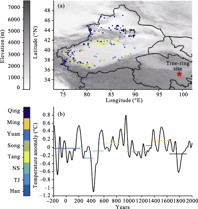
Figure 1 Overview of the study area (a) and the temperature sequence of the past 2000 years (b). In (a), colored dots indicate abandoned settlements in corresponding dynasties. The star is the location of temperature series of the A’nyemaqen Mountains. In (b), the black solid line represents a 30-year moving average reconstructed April-June maximum temperature by tree-ring width chronology in the A’nyemaqen Mountains (red pentagram) (Chen, 2016); colored segments represent average temperature in each dynasty and the length of the segments indicates the length of the dynasties. In the abbreviation of the dynasty marked in the legend, TJ means Two Jin Dynasties (280-420AD) and NS means Northern and Southern Dynasties (420AD-589AD).
Table 1 Temperature anomaly and the number of settlements in each dynasty in Xinjiang during the last 2000 years
Dynasty (years)
(Wan, 1978)
Length of
dynasty (years)
Number of settlements Temperature
anomaly (°C)
Northern Xinjiang Southern Xinjiang
Han (206BC-220AD) 426 15 99 -0.0179
Two Jin (280AD-420AD) 140 5 86 -0.2632
Northern and Southern Dynasties (420AD-589AD) 169 13 95 -0.0868
Tang (618AD-907AD) 289 62 237 0.1096
Song (960AD-1279AD) 319 36 94 -0.0994
Yuan (1279AD-1368AD) 89 38 16 0.0493
Ming (1368AD-1644AD) 276 9 7 0.1748
Qing (1644AD-1911AD) 267 86 57 -0.1595

2.3 Methods

In Xinjiang, abandoned settlements were generally distributed on the oases of different sizes. For spatial comparison of the settlements between the dynasties, we draw dynastic settlements in each dynasty with topography and rivers. For calculating the number of settlements, we divided Xinjiang into two parts of north and south by 42.5°N and calculated the number of settlements of 8 dynasties in each part. We compared the temperature and the number of settlements in Northern and Southern Xinjiang in each dynasty.
Water is the basis for the survival of oasis in the arid area. The change of water amount could directly affect the prosperity and disappearance of an oasis (Sun, 2015; Hou, 2009; Liang and Zhou, 2010; Liu, 2003). The water resources in the oases of the Tarim Basin mainly depend on the river supply. The river with the larger runoff can provide more abundant water resources and maintain bigger oases (Liang and Zhou, 2010; Yang, 2014). In this paper, we test the relationship between the number of settlements and oasis area of each river basin in Xinjiang. According to the division on the watersheds in the Tarim Basin (Liang and Zhou, 2010), we calculated the number of abandoned settlements for each of the 16 river basins and used linear regression to analyse the relation between oasis area and the number of settlements in each river basin, in order to understand the relation between the number of abandoned settlements and oasis area.

3 Results

3.1 Spatial and temporal changes in settlements under different climatic conditions

During the warm period of the Han Dynasty, there were a total of 99 known settlements located in Southern Xinjiang, as seen in Table 1. Most of them concentrated in large oases of the piedmont alluvial-proluvial fans. The number of settlements in Northern Xinjiang was only 15, with almost blank in Junggar Basin (Figure 2a).
Compared to the Han Dynasty, the Jin Dynasty and Northern and Southern Dynasties were in a cold period. The Jin Dynasty featured 86 settlements in Southern Xinjiang and 5 settlements in Northern Xinjiang. The settlements originally distributed around small river basins in Southern Xinjiang had disappeared in the Jin Dynasty. A total of 95 settlements located in Southern Xinjiang during the period of Northern and Southern Dynasties and only 15 settlements distributed in Northern Xinjiang under a slight increase in temperature (Table 1). Overall, the locations of the settlements in the Northern and Southern period remained roughly similar to those in the Jin Dynasty (Figure 2b).
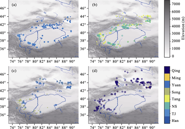
Figure 2 Spatial distribution of settlements over 8 dynasties in Xinjiang, with topography (colorful dots represent settlements in the corresponding dynasty; the blue line indicates the location of the rivers). (a) Settlements in Han and Two Jin Dynasty (TJ); (b) Settlements in Northern and Southern Dynasty (NS) and Tang Dynasties; (c) Settlements in Song and Yuan dynasties; (d) Settlements in Ming and Qing dynasties.
During the history of Xinjiang in the last 2000 years, the Tang Dynasty was definitely the most prosperous period when was also a warm period. In the Tang Dynasty, the number of settlements increased dramatically to 237 in Southern Xinjiang and 62 in Northern Xinjiang with the rise of temperature. The Yarkand river basin in Southern Xinjiang witnessed the appearance of a large number of settlements. This increase also appeared in the Yili river valley and area north of Bogda Mountains in Northern Xinjiang. From the Tang to the Song Dynasty, as the temperature decreased, the number of settlements dropped substantially to 94 and 36 in Southern and Northern Xinjiang respectively (Figure 2c).
From the Song to the Yuan Dynasty, with slight increase in temperature, settlements reappeared at small oases such as Qiemo. But the total number of settlements in the Yuan Dynasty was less than that in the Song Dynasty with 16 and 38 in Southern and Northern Xinjiang respectively, that might be because Xinjiang was actually controlled by Chagatai Khanate in the Yuan Dynasty. However, from the Yuan to the Ming Dynasty, even as the temperature continued rising, the number of settlements still decreased to 7 and 9 in Southern and Northern Xinjiang (Figure 2d), that might be because the central government of China lost its jurisdiction on Xinjiang during the Ming Dynasty (Fang, 1989).
From the Ming to the Qing Dynasty, as the temperature decreased drastically, the number of settlements still increased, which was directly related to the fact to the region was under the jurisdiction of the central government of China again, and the policy of cultivation for the military by the Qing government (Fang, 1989). The number of settlements was 57 and 85 in Southern and Northern Xinjiang respectively.
During the Yuan, Ming, and Qing dynasties, although the number of settlements increased, the spatial distribution of them still concentrated in the intermontane basins at higher elevations and upstreams of the alluvial-proluvial fans (Figure 2). Settlements in small oases east of the Keriya River located in the piedmont areas of northern Kunlun Mountains were all abandoned in the Ming and Qing dynasties within the Little Ice Age (Table 1). Even settlements located at larger river basins like Kuqa and Korla also continued into obsolescence during the Yuan, Ming, and Qing dynasties (Figure 2d). Before the Qing Dynasty, the number of settlements in Northern Xinjiang is less than that in Southern Xinjiang, mainly due to the long-term nomadic status of the northern part.

3.2 The stability of the settlements to temperature change in different sizes of oases

The Tarim Basin could be divided into 16 watersheds (Liang and Zhou, 2010). We calculated the number of abandoned settlements in each one (Table 2). In general, larger river basins for more water supply supported more settlements than smaller ones (Figure 3).
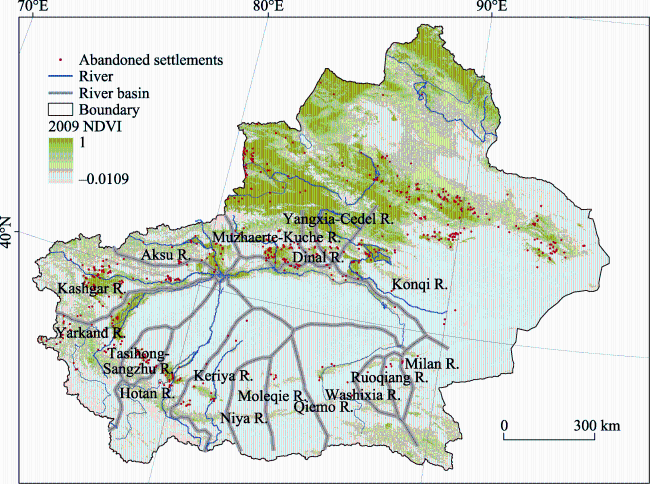
Figure 3 Spatial distribution of abandoned settlements in 16 river basins in the Tarim Basin. NDVI in 2009 was used to indicate vegetation distribution in Xinjiang. This dataset was provided by International Scientific & Technical Data Mirror Site, Computer Network Information Center, Chinese Academy of Sciences. (http://www. gscloud.cn).
A clear positive linear relation between the area of oasis and the total number of abandoned settlements in the Tarim Basin with 0.91 (P<0.01) correlation coefficient was found. The regression showed that when size of oasis expanded by 1000 km2, the number of settlements could increase by 7 (Figure 4b).
Table 2 Area of oases (Liang and Zhou, 2010) and the number of abandoned settlements of each river basin in the Tarim Basin
Name of river basin Area of oasis (km2) Number of abandoned settlements
Kashgar river 12719.54 91
Yarkand river 9951.36 44
Aksu river 7025.53 28
Muzart-Kuche river 6824.42 64
Hotan river 3138.23 22
Konqi river 3021.23 37
Cele-kaxi-Keriya river 1732.43 15
Qiemo river 757.40 6
Dinal river 712.51 14
Yangxia-Cedel river 582.66 8
Tasihong-Sangzhu river 506.27 23
Niya river 257.31 1
Ruoqiang river 80.69 4
Milan river 66.44 3
Washixia river 58.68 1
Bositantuoge lake-Alamilan-Moleqie river 21.19 4

The gray color indicates oasis area less than 2000 km2.

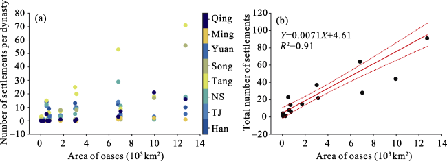
Figure 4 The relation between area of oasis and number of settlements. (a) Scatter plot between area of oasis and number of settlements in corresponding dynasty (colored solid dots represent corresponding dynasty); (b) Linear regression between area of oasis and total number of abandoned settlements in the Tarim Basin.
Beside the total number of abandoned settlements, we also calculated the number of settlements of each oasis in each dynasty. The scatter plot showed that the Tang Dynasty was the most prosperous period in the Tarim Basin during the past 2000 years, with settlements distributed across oases of different sizes and increasing significantly and steadily with the increase in size of the oases. The scatter plot also showed that the number of settlements in each dynasty fell to less than 20 when the oasis area was less than 2000 km2 (Figure 4b), which were prone to abandoned land due to climate deterioration (Table 2). When temperature decreased, the settlements distributed in small oases, such as the Milan, Ruoqiang, Washixia, and Niya basins, were soon abandoned, whereas settlements located on large oases with sufficient glacier water supply were more stable, such as in the Kashgar and Aksu basins.

4 Conclusions and discussion

Xinjiang was an important channel to communicate between China and Europe, and had multiple prosperous civilizations in the history. In this study, we created a database of abandoned settlements in Xinjiang from 206BC to 1911AD by extracting data from Atlas of Chinese Cultural Relics: Xinjiang Volume (Elken, 2012). Through the analysis of change of settlements in Xinjiang during the last 2000 years, we concluded that:
1) There were 99 and 15 settlements located in Southern and Northern Xinjiang during the warm period of the Han Dynasty. From the Han Dynasty to the Two Jin, with the temperature drop, the number of settlements decreased to 86 and 5 respectively in Southern and Northern Xinjiang. Slight temperature increase from Two Jin to Northern and Southern Dynasties corresponded to settlement increase to 95 and 13 in Southern and Northern Xinjiang. Until the Tang Dynasty, a significant rise in temperature was accompanied by a large number of settlement increase to 237 and 62 in Southern and Northern Xinjiang. There are 94 and 36 settlements in the Song Dynasty with the temperature decreasing from the Tang to the Song Dynasty. Although the Yuan Dynasty belonged to warm period compared with the Song Dynasty, settlements still reduced to 16 and 38 due to Chagatai Khanate’s control. From the Yuan to the Ming dynasty, even as the temperature continued rising, the number of settlements still reduced to 7 and 9 in Southern and Northern Xinjiang, that might be because the central government of China lost its jurisdiction of Xinjiang during the Ming Dynasty. From the Ming to the Qing Dynasty, as the temperature decreased drastically, the number of settlements increased to 57 and 86 in Southern and Northern Xinjiang, which was directly related to the fact that the region was under the jurisdiction of the central government of China again, and the policy of cultivation for the military by the Qing government.
2) The settlements were more stable on the oases larger than 2000 km2 in the Tarim Basin than those on small oases. Historical settlements could be built on the oases in small river basins and the middle and lower reaches of the rivers during the warm periods, and they shrank back to the larger oases during the cold periods over the past 2000 years.
3) There were positive correlations between temperature fluctuation and location of settlements, oasis area, and number of settlements over the last 2000 years. In the Tarim Basin, the number of settlements in each dynasty increased significantly with the increase in size of the oases.
Under the extremely arid conditions of Xinjiang, water affected by climate change is the critical factor for agriculture and human living. We interpret the mechanism of relationship between climate change and abandoned settlements is that colder climate reduced glacier meltwater, shortened rivers, atrophied oases, and intensified desertification, which ultimately resulted in the settlement’s abandonment. Unfortunately, the shortage of intermediate information on these links limited our further interpretation on the mechanism.
The establishment and abandonment of settlements have complex influencing factors including military force of central government of China. In this paper, we only consider the coincidence between temperature change and settlement distribution. Other social factors and complex mechanism should be studied further in the future.

The authors have declared that no competing interests exist.

[1]
Berglund B E, 2003. Human impact and climate changes: Synchronous events and a causal link?Quaternary International, 105: 7-12. doi: 10.1016/s1040-6182(02)00144-1.Interaction between cultural development and the natural environment is generally accepted. Holocene climate change is described as one of the main environmental factors behind a step-wise development of the cultural landscape in Northwest Europe. Seven periods of human impact changes—5900, 5500, 4500, 3800, 3000–2800, 1500 and ja:math BP—are defined and compared with reconstructed climatic scenarios, based on insolation, glacier activity, lake and sea levels, bog growth, tree line, and tree growth. There is a positive correlation between human impact/land-use and climate change, although precise correlations are difficult because of weaknesses in the chronology. Future studies of annually laminated (varved) lake sediments and wiggle-matched radiocarbon sequences are emphasized, as well as a combination of palaeoecology and archaeology. It is hypothesized that agrarian society and the landscape developed step-wise, dependent on the interaction between the technological/social complex and the ecological capacity of a region, highly influenced by climate.

DOI

[2]
Buckley B M, Anchukaitis K J, Penny Det al., 2010. Climate as a contributing factor in the demise of Angkor, Cambodia.Proceedings of the National Academy of Sciences of the United States of America, 107: 6748-6752. doi: 10.1073/pnas.0910827107.Abstract The "hydraulic city" of Angkor, the capitol of the Khmer Empire in Cambodia, experienced decades-long drought interspersed with intense monsoons in the fourteenth and fifteenth centuries that, in combination with other factors, contributed to its eventual demise. The climatic evidence comes from a seven-and-a-half century robust hydroclimate reconstruction from tropical southern Vietnamese tree rings. The Angkor droughts were of a duration and severity that would have impacted the sprawling city's water supply and agricultural productivity, while high-magnitude monsoon years damaged its water control infrastructure. Hydroclimate variability for this region is strongly and inversely correlated with tropical Pacific sea surface temperature, indicating that a warm Pacific and El Ni脙卤o events induce drought at interannual and interdecadal time scales, and that low-frequency variations of tropical Pacific climate can exert significant influence over Southeast Asian climate and society.

DOI PMID

[3]
Büntgen U, Tegel W, Nicolussi Ket al., 2011. 2500 years of European climate variability and human susceptibility. Science, 331: 578-582. doi: 10.1126/science.1197175.Climate variations influenced the agricultural productivity, health risk, and conflict level of preindustrial societies. Discrimination between environmental and anthropogenic impacts on past civilizations, however, remains difficult because of the paucity of high-resolution paleoclimatic evidence. We present tree ring-揵ased reconstructions of central European summer precipitation and temperature variability over the past 2500 years. Recent warming is unprecedented, but modern hydroclimatic variations may have at times been exceeded in magnitude and duration. Wet and warm summers occurred during periods of Roman and medieval prosperity. Increased climate variability from ~250 to 600 C.E. coincided with the demise of the western Roman Empire and the turmoil of the Migration Period. Such historical data may provide a basis for counteracting the recent political and fiscal reluctance to mitigate projected climate change.

DOI PMID

[4]
Butzer K W, 2005. Environmental history in the Mediterranean world: Cross-disciplinary investigation of cause-and-effect for degradation and soil erosion.Journal of Archaeological Science, 32: 1773-1800. doi: 10.1016/j.jas.2005.06.001.Environmental history is a multidisciplinary enterprise united by shared interests in ecological change and the complex interactions between people and the environment. Its practitioners include expertise in the natural sciences, in history or archaeology, or in political ecology and related social sciences; but there is no agreement on a common agenda and limited success in bridging methodological and epistemological divisions that impede integrative and interdisciplinary research. World-systems history and environmental history also have overlapping interests in long-term change and matters of sustainability. The Mediterranean world sustained agricultural lifeways across some 8000 years, yet its environment has repeatedly been described as degraded, suggesting conceptual confusion between transformation and destruction. This paper is didactic in purpose and uses landscape histories for the Peloponnese and eastern Spain to show that the impact of recurrent, excessive precipitation events and of reduced quality of land cover are difficult to unravel, because they commonly appear to work in tandem. As a result (a) environmental change cannot be assumed or “predicted”, but must be studied inductively by experts with science skills, and (b) cause-and-effect relationships demand an understanding of ecological behavior, for which humanistic insights are indispensable. Social science models highlight systemic relationships from socioeconomic and structural perspectives, but are less suited to deal with the complexity of environmental change or the contingencies exemplified by human resilience. Near Eastern, Greek and Roman agronomic writings offer elite “voices” that speak to cumulative technological change, scientific understanding, and the context of intensification. Rural voices can be heard through ethnography, and in eastern Spain are extended into the past by archaeology and archival research. In the absence of structural constraints, they reveal collective decision-making with respect to a shifting repertoire of agricultural strategies that take into account market opportunities, demographic growth, finite resources and environmental problems. Such adaptability spells resilience, and “good farming” is culturally embedded as a civic responsibility, both in the ethnographic present and in the older, elite agronomic writings. But if the “moral economy” erodes in the wake of food stress, tax extortion, instability, insecurity, or ideological oppression, there is little incentive to pursue long-term strategies, so that behavior focuses on short-term survival. The context for this dialectic of poor versus good ecological management may be structural, but cause-and-effect in the traditional Mediterranean world ultimately depended on ecological and human resilience. Long-term sustainability is similarly non-predictive. It depends on people, rather than social theory.

DOI

[5]
Carrión J S, Fuentes N, Samperiz P Get al., 2007. Holocene environmental change in a montane region of southern Europe with a long history of human settlement.Quaternary Science Reviews, 26: 1455-1475. doi: 10.1016/j.quascirev.2007.03.013.This paper uses a palynological sequence to examine the Holocene (8390–16002cal02yr02BP) environmental history of the Sierra de Baza (Granada, southeastern Spain) with the goal of establishing the mechanisms exerting control over vegetation change. During the period ca 8390–632002cal02yr02BP, Pinus dominated the pollen spectra, indicating a forested landscape over the high-elevation areas of the Sierra. From ca 6320–380002cal02yr02BP, an expansion of deciduous oaks and other broad-leaf trees took place. After an optimum around 5800–560002cal02yr02BP, mesophytes decreased in the 3800–256002cal02yr02BP interval while a fire-prone scrub became established. The main loss of forest accompanied the spread of thorny matorral after ca 256002cal02yr02BP. Overall, this mountain region has shown itself to be sensitive to a range of influences, among which a continental climate that has become increasingly arid over the last 5000 years, the scarcity of soils suitable for cultivation, a geology that includes sources of copper and other metals and, especially, the incidence of grazing as well as the repeated appearance of fires during the last 4000 years, are highlighted. The history of the vegetation of the Sierra de Baza seems clearly influenced by changes in local economy. Here we discuss how ecological transitions have interacted with cultural changes, with emphasis on the locally highly populated Chalcolithic (5700–440002cal02yr02BP) and Argaric (4400–355002cal02yr02BP) periods, as well as the Iberian period (3200–222002cal02yr02BP). The sierra was abandoned during the Iberian Period which was, paradoxically, when the highest human impact on mountain vegetation is noticeable.

DOI

[6]
Chen Feng, Zhang Yong, Shao Xuemeiet al., 2016. A 2000-year temperature reconstruction in the Animaqin Mountains of the Tibet Plateau, China.The Holocene, 0959683616646187.Abstract A 2665-year ring-width chronology was developed based on Qilian juniper from the upper treeline of the Animaqin Mountains on the eastern Tibetan Plateau. Correlation analysis results showed that the chronology was significantly negatively correlated with April–June maximum temperature at nearby meteorological stations, indicating that maximum temperature is the factor that limits tree growth in this area. Accordingly, we reconstructed the average April–June maximum temperature variations since 261 BC. Our regression model explained 37.9% of the total variance for the whole calibration period of 1960–2012. Our reconstruction revealed that the maximum temperature started to increase from approximately 1750 without a rapid warming trend, and the warmest period was from AD 890 to 947, as opposed to the recent period, whereas the period from AD 351–483 was the coldest. Significant periods in the wavelet power spectrum were approximately 2–8 years, 20–30 years, 30–60 years, and 60–130 years, as well as some long-term periods (more than 200 years). Comparisons with other temperature series from neighboring regions and the Northern Hemisphere as a whole support the validity of our reconstruction and suggest that it provides a representation of the temperature change for the Animaqin area, although asymmetric variation patterns in minimum and maximum temperatures were found.

DOI

[7]
Ding Yongjian, Liu Shiyin, Li Jing, .

[8]
Dugmore A J, Keller C, McGovern T H et al., 2009. Norse Greenland settlement and limits to adaptation. In: Adapting to Climate Change: Thresholds, Values, Governance. Cambridge: Cambridge University Press.

[9]
Elken M, 2012. Atlas of Chinese Cultural Relics: Xinjiang Volume. Beijing: Cultural Relics Press.

[10]
Fang Xiuqi, Xiao Lingbo, Wei Zhudeng, 2013. Social impacts of the climatic shift around the turn of the 19th century on the North China Plain.Science China Earth Sciences, 56: 1044-1058. doi: 10.1007/s11430-012- 4487-z.Historical case studies of climate change impacts and the resulting social responses can provide analogies for better understanding the impacts of current and future climate changes. Around the turn of the 19th century, the climate of the North China Plain experienced a shift from a relatively warm stage in the 18th century to a colder stage in the 19th century, which was characterised by a much colder climate and more frequent and severe floods and droughts. Historical information about refugees, social disorder, grain transportation, and disaster relief on the North China Plain in 1780–1819 is collected from the Veritable Records of the Qing Dynasty (a collection of official records). The mechanism of climate change affecting the food security of the society, as indicated by the development of a refugee problem around the turn of the 19th century, is analyzed by examining the social vulnerability. There are four basic findings: (1) In the 40 years from 1780–1819, the society on the North China Plain was unstable and characterised by a significant deterioration of the refugee situation. The number of refugees increased markedly, and their behaviour became increasingly violent. In the 1780s, most of the disaster victims chose to stay at their residences waiting for relief. From 1790 to 1800, hundreds of thousands of refugees migrated to northeast China. In the 1810s, the frequency of farmer rebellions increased sharply. (2) The increase in instability corresponded to the climatic cooling over the same time period. The increased instability was a result of the negative impacts of climate change accumulating and transmitting to the social level. (3) For food security, a precondition for the negative impacts of climate change on human society was the vulnerability of the regional socioeconomic system, which had a high sensitivity and low capacity to respond. This vulnerability could be described by the following three observations: ① The regional balance of supply and demand for food was in a critical state, which led to a high sensitivity and dramatic reduction in yield that was caused by climate change; ② the capacity for disaster relief efforts by the government was too low to meet the needs of crisis management; ③ the capacity for refugees’ resettlement in eastern Inner Mongolia and northeast China, which both border the North China Plain, was severely restricted by climatic conditions or the quarantine policy. (4) It is estimated that climate change caused the social vulnerability to reach a critical level approximately 20 years earlier on the North China Plain.

DOI

[11]
Fang Yingkai, 1989. The History of Xinjiang Reclamation. Urumqi: Xinjiang Juvenile Publishing House. (in Chinese)

[12]
Ge Quansheng, Hao Zhixin, Zheng Jingyunet al., 2013. Temperature changes over the past 2000 yr in China and comparison with the Northern Hemisphere.Climate of the Past, 9: 1153-1160. doi: 10.5194/cp-9-1153-2013.We use principal component regression and partial least squares regression to separately reconstruct a composite series of temperature variations in China, and associated uncertainties, at a decadal resolution over the past 2000 yr. The reconstruction is developed using proxy temperature data with relatively high confidence levels from five regions across China, and using a temperature series from observations by the Chinese Meteorological Administration, covering the period from 1871 to 2000. Relative to the 1851-1950 climatology, our two reconstructions show four warm intervals during AD 1 AD 200, AD 551 AD 760, AD 951 AD 1320, and after AD 1921, and four cold intervals during AD 201 AD 350, AD 441 AD 530, AD 781 AD 950, and AD 1321 AD 1920. The temperatures during AD 981 AD 1100 and AD 1201 AD 1270 are comparable to those of the Present Warm Period, but have an uncertainty of +0.28 C to 0.42 C at the 95 % confidence interval. Temperature variations over China are typically in phase with those of the Northern Hemisphere (NH) after 1000, a period which covers the Medieval Climate Anomaly, the Little Ice Age, and the Present Warm Period. In contrast, a warm period in China during AD 541 AD 740 is not obviously seen in the NH.

DOI

[13]
Gilbert M T, Kivisild T, Grønnow Bet al., 2008. Paleo-Eskimo mtDNA genome reveals matrilineal discontinuity in Greenland.Science, 320: 1787-1789. doi: 10.1126/science.1159750.Abstract The Paleo-Eskimo Saqqaq and Independence I cultures, documented from archaeological remains in Northern Canada and Greenland, represent the earliest human expansion into the New World's northern extremes. However, their origin and genetic relationship to later cultures are unknown. We sequenced a mitochondrial genome from a Paleo-Eskimo human by using 3400-to 4500-year-old frozen hair excavated from an early Greenlandic Saqqaq settlement. The sample is distinct from modern Native Americans and Neo-Eskimos, falling within haplogroup D2a1, a group previously observed among modern Aleuts and Siberian Sireniki Yuit. This result suggests that the earliest migrants into the New World's northern extremes derived from populations in the Bering Sea area and were not directly related to Native Americans or the later Neo-Eskimos that replaced them.

DOI PMID

[14]
Han Wenxia, Yu Lupeng, Lai Zhongpinget al., 2014. The earliest well-dated archeological site in the hyper-arid Tarim Basin and its implications for prehistoric human migration and climatic change.Quaternary Research, 82: 66-72.The routes and timing of human occupation of the Tibetan Plateau (TP) are crucial for understanding the evolution of Tibetan populations and associated paleoclimatic conditions. Many archeological sites have been found in/around the Tarim Basin, on the northern margin of the Tibetan Plateau. Unfortunately, most of these sites are surface sites and cannot be directly dated. Their ages can only be estimated based on imprecise artifact comparisons. We recently found and dated an archeological site on a terrace along the Keriya River. Our ages indicate that the site was occupied at ~027.0–7.602ka, making it the earliest well-dated archeological site yet identified in the Tarim Basin. This suggests that early human foragers migrated into this region prior to ~027.0–7.602ka during the early to mid-Holocene climatic optimum, which may have provided the impetus for populating the region. We hypothesize that the Keriya River, together with the other rivers originating from the TP, may have served as access routes onto the TP for early human foragers. These rivers may also have served as stepping stones for migration further west into the now hyper-arid regions of the Tarim Basin, leading ultimately to the development of the Silk Road.

DOI

[15]
Haug G H, Günther D, Peterson L Cet al., 2003. Climate and the collapse of Maya civilization.Science, 299: 1731-1735. doi: 10.1126/science.1080444.In the anoxic Cariaco Basin of the southern Caribbean, the bulk titanium content of undisturbed sediment reflects variations in riverine input and the hydrological cycle over northern tropical South America. A seasonally resolved record of titanium shows that the collapse of Maya civilization in the Terminal Classic Period occurred during an extended regional dry period, punctuated by more intense multiyear droughts centered at approximately 810, 860, and 910 A.D. These new data suggest that a century-scale decline in rainfall put a general strain on resources in the region, which was then exacerbated by abrupt drought events, contributing to the social stresses that led to the Maya demise.

DOI PMID

[16]
Hou Yongjian, 2009. Niya River, a runoff from West Kunlun Mountains and Niya settlements.The Western Regions Studies, 1: 45-54.Niya River, a runoff from West Kunlun Mountains, is formed by glacial meltwater from the upper reaches of Niya River and rainfall in West Kunlun Mountains. It gradually dried up after entering plain and tail areas, caused by dry climate of the Taklimakan Desert. Over the last 100 years, great successes were achieved in archaeological and historical research on Niya site. The change from settlements to ruins in Niya indicates the fact of water sources scarcity of Niya River. After the Wei and Jin dynasties, due to the decrease of its transportation importance, the administration organization in Niya was abandoned. The settlement to the north of the Kapak-askan village was abandoned because of the scarcity of water sources too.

[17]
Issar A S, Zohar M, 2007. Climate Change: Environment and History of the Near East. Berlin: Springer.This survey of the ancient levels of lakes, rivers and the sea, as well as changes in the compositions of stalagmites and sediments reveals an astonishing correlation of climate changes with the emergence and collapse of civilizations in the Middle East. The authors conclude that climate change has been the decisive factor in the history surrounding the origins of the "cradle of civilization".

DOI

[18]
Kennett D J, Breitenbach S F M, Aquino V Vet al., 2012. Development and disintegration of Maya political systems in response to climate change.Science, 338: 788-791. doi: 10.1126/science.1226299.The role of climate change in the development and demise of Classic Maya civilization (300 to 1000 C.E.) remains controversial because of the absence of well-dated climate and archaeological sequences. We present a precisely dated subannual climate record for the past 2000 years from Yok Balum Cave, Belize. From comparison of this record with historical events compiled from well-dated stone monuments, we propose that anomalously high rainfall favored unprecedented population expansion and the proliferation of political centers between 440 and 660 C.E. This was followed by a drying trend between 660 and 1000 C.E. that triggered the balkanization of polities, increased warfare, and the asynchronous disintegration of polities, followed by population collapse in the context of an extended drought between 1020 and 1100 C.E.

DOI PMID

[19]
Kutuzov S, Shahgedanova M, 2009. Glacier retreat and climatic variability in the eastern Terskey-Alatoo, inner Tien Shan between the middle of the 19th century and beginning of the 21st century.Global and Planetary Change, 69: 59-70. doi: 10.1016/j.gloplacha.2009.07.001.Changes in the extent of glaciers and rates of glacier termini retreat in the eastern Terskey–Alatoo Range, the Tien Shan Mountains, Central Asia have been evaluated using the remote sensing techniques. Changes in the extent of 335 glaciers between the end of the Little Ice Age (LIA; mid-19th century), 1990 and 2003 have been estimated through the delineation of glacier outlines and the LIA moraine positions on the Landsat TM and ASTER imagery for 1990 and 2003 respectively. By 2003, the glacier surface area had decreased by 19% of the LIA value, which constitutes a 76km 2 reduction in glacier surface area. Mapping of 109 glaciers using the 1965 1:25,000 maps revealed that glacier surface area decreased by 12.6% of the 1965 value between 1965 and 2003. Detailed mapping of 10 glaciers using historical maps and aerial photographs from the 1943–1977 period, has enabled glacier extent variations over the 20th century to be identified with a higher temporal resolution. Glacial retreat was slow in the early 20th century but increased considerably between 1943 and 1956 and then again after 1977. The post-1990 period has been marked by the most rapid glacier retreat since the end of the LIA. The observed changes in the extent of glaciers are in line with the observed climatic warming. The regional weather stations have revealed a strong climatic warming during the ablation season since the 1950s at a rate of 0.02–0.03°C a 61021 . At the higher elevations in the study area represented by the Tien Shan meteorological station, the summer warming was accompanied by negative anomalies in annual precipitation in the 1990s enhancing glacier retreat. However, trends in precipitation in the post-1997 period cannot be evaluated due to the change in observational practices at this station. Neither station in the study area exhibits significant long-term trends in precipitation.

DOI

[20]
Liang Jianming, Zhou Jie, 2010. Relationship between oases distribution and stream runoff in the Tarim Basin.Journal of Arid Land Resources and Environment, 24(4): 50-54. (in Chinese)Oases in the Tarim basin were extracted using 2007 SPOT NDVI dataset.It was concluded that oases in the Tarim Basin cover an area of 54923.86 km2,making up about 10% of the entire basin;oases and desert steppe together occupy an area of 101392.56 km2,making up about 18% of the of the entire basin.The extracted oases were divided into 17 watershed-based areas by applying Distance Analysis in ArcGIS package.The relationship between the runoff and the oasis area within a watershed-based area was assessed and a significant correlation was found between the magnitude of runoff and the area of oasis.

DOI

[21]
Liu Shiyin, Sun Wenxin, Shen Yongpinget al., 2003. Glacier changes since the Little Ice Age maximum in the western Qilian Shan, northwest China, and consequences of glacier runoff for water supply.Journal of Glaciology, 49(164): 117-124.Based on aerial photographs, topographical maps and the Landsat-5 image data, we have analyzed fluctuations of glaciers in the western Qilian Shan, northwest China, from the Little Ice Age (LIA) to 1990. The areas and volumes of glaciers in the whole considered region decreased 15% and 18%, respectively, from the LIA maximum to 1956.This trend of glacier shrinkage continued and accelerated between 1956 and 1990. These latest decreases in area and volume were about 10% in 34 years. The recent shrinkage may be due either to a combination of higher temperatures and lower precipitation during the period 1956-66, or to continuous warming in the high glacierized mountains from 1956 to 1990. As a consequence, glacier runoff from ice wastage between 1956 and 1990 has increased river runoff by 6.2 kmin the four river basins under consideration. Besides, the equilibrium-line altitude (ELA) rise estimated from the mean terminus retreat of small glaciers <1km long is 46 m, which corresponds to a 0.3掳C increase of mean temperatures in warm seasons from the LIA to the 1950s.

DOI

[22]
Nunn P D, Hunter-Anderson R, Carson S Tet al., 2007. Times of plenty, times of less: Last-millennium societal disruption in the Pacific Basin.Human Ecology, 35: 385-401. doi: 10.1007/s10745-006-9090-5.During the last millennium in the Pacific Basin (islands and continental rim) there was a marked contrast between ‘times of plenty’ and ‘times of less’ for its human societies. This contrast is attributable to climate and sea-level variations, notably the Medieval Warm Period ( a.d. 700–1250) and the Little Ice Age ( a.d. 1350–1800) separated by a time of rapid cooling and sea-level fall called the ‘ a.d. 1300 Event.’ Outlines of the times of plenty during the Medieval Warm Period and the times of less during the Little Ice Age are given, supported by a number of examples. These confirm a general picture of societal collapse as a result of the a.d. 1300 Event. Well-dated human responses to the a.d. 1300 Event (establishment of fortified settlements, end of ocean voyaging) allow links to potential nonhuman causes to be strengthened. Although more data referring to both (natural) changes and their human effects are needed, a conclusion involving environmental determinism is inescapable.

DOI

[23]
Polyak V J, Asmerom Y, 2001. Late Holocene climate and cultural changes in the Southwestern United States.Science, 294: 148-151. doi: 10.1126/science.1062771.Columnar stalagmites in caves of the Guadalupe Mountains during the late Holocene record a 4000-year annually resolved climate history for the southwestern United States. Annual banding, hiatuses, and high-precision uranium-series dating show a present day-like climate from 4000 to 3000 years ago, following a drier middle Holocene. A distinctly wetter and cooler period from 3000 to 800 years ago was followed by a period of present day-like conditions, with the exception of a slightly wetter interval from 440 to 290 years before the present. The stalagmite record correlates well with the archaeological record of changes in cultural activities of indigenous people. Such climate change may help to explain evidence of dwelling abandonment and population redistribution.

DOI PMID

[24]
Shu Qiang, Zhong Wei, Li Cai, 2007. Distribution feature of ancient ruins in south edge of Tarim Basin and relationship with environmental changes and human activities. Journal of Arid Land Resources and Environment, 21(11): 95-100. (in Chinese)Based on the archaeological documents and the historical records,it was found that the ancient ruins in south edge of Tarim basin have inimitable distribution feature: The abandonment time concentrated on certain periodes;The ancient ruins in south edge of Tarim basin abandoned in the 4th~5th century,7th~8th century,11th century and 13th century.The spacial feature has the trend that the human being's living spaces were dwindling.The abandonment time of ancient ruins coincided with the abrupt climate change period and the peak of war greatly.In 4th-5th century,the abandonment cause of ancient ruins was probably the abrupt warm-dry change of the climate.In 7th~8th century,the abandonment cause of ancient ruins was probably the rebellion of the west Turki and the inbreak of Tibetan.In 11th century,the abandonment cause of ancient ruins was probably the warm-dry climate and the Crusade.In 13th century,the abandonment cause of ancient ruins was probably the rebellion of Haidu and Duwa.Moreover,some unconscionable human activity destroed entironment and accelerated the abandonment process of ancient ruins.

[25]
Wan Guoding, 1978. Chinese History Chronology. Beijing: Zhonghua Book Company.

[26]
Wang Zhichao, 2010. The changes of Lop Nur Lake and the disappearance of Loulan.Journal of Arid Land, 2: 295-303.

[27]
Wei Zhudeng, Fang Xiuqi, Su Yun, 2014. Climate change and fiscal balance in China over the past two millennia.The Holocene, 24: 1771-1784. doi: 10.1177/0959683614551224.ABSTRACT The relation between climate change and historical rhythms has long been discussed; however, this type of study still faces the lack of high-resolution data of long-term socio-economic processes. In this study, we collected 1101 items of direct and proffered evidence from 24 Chinese fiscal and economic history books written by leading contemporary scholars. By analysing the semantics of words, we reconstructed a 2130-year-long fiscal sequence with decadal resolution to express the phase transition of fiscal soundness for approximately 21 dynasties in China. Our reconstruction shows four relatively sufficient stages and three relatively deficient stages, with several secondary stages lasting 60 or 160 years on average within each large stage, from 220 bc to ad 1910. Then, the fiscal association with climate change was analysed. The results show that the fiscal crisis was more likely to occur in cold-dry climatic scenarios. Both temperature and precipitation displayed more significant effects on the fiscal fluctuation within the long term, particularly for temperature. In short, fiscal decline had a 10-year lag in response to decreasing precipitation, whereas influence of decreasing temperature on the fiscal balance might be through amplifying already deteriorating fiscal conditions. Regional differences existed in the influence of precipitation on the fiscal balance. The precipitation in the Northern China Plain and in the Jiang-Huai area had more significant effects on the fluctuation of the dynastic fiscal balance than on that in the Jiang-Nan area. In particular, the dynastic finance was more sensitive to the change in the precipitation in the Northern China Plain because of its special geographical, economic and social backgrounds.

DOI

[28]
Wei Zhudeng, Rosen A M, Fang Xiuqiet al., 2015. Macro-economic cycles related to climate change in dynastic China.Quaternary Research, 83: 13-23. doi: 10.1016/j.yqres.2014.11.001.Investigations of the relationships between climate and human history often place more emphasis on the science of climate change than on understanding human socio-economic processes, and therefore suffer from superficial results and an unbalanced perspective. This is partly due to the lack of high-resolution data concerning long-term socio-economic processes. Here, we base our study of climate and society on a series of 2130-yr-long economic proxy data from China with decadal resolution. The economy was associated significantly with temperature and precipitation at the two predominant bands of 100 and 320 yr. The phase transition of economic states was influenced positively by long-term temperature change combined with triggering effects of short-term changes in precipitation. However, climatic impact on economy should not be recognized as simple causality but some driving&ndash;response relation coupled with meditation by human agency at multiple scales. A model of &lsquo;adaptive cycles&rsquo; implies, in relative to the developing phases, climate&ndash;economy relationship during the declining phases was more easily moderated by slower processes like rigidity and faster processes like unrest. From a more-macro perspective, climatic driving for the macro-economic cycles was moderated by larger and slower processes like social memory, spatial shifting of key economic areas, and social&ndash;technical advance.

DOI

[29]
Xiao Lingbo, Fang Xiuqi, Zhang Yujieet al., 2014. Multi-stage evolution of social response to flood/drought in the North China Plain during 1644-1911.Regional Environmental Change, 14: 583-595. doi: 10.1007/s10113-013-0516-5.How the past human society responded to climatic disasters could provide better understanding on the nature of climate–human–ecosystem interactions and the knowledge of the vulnerability for the society in the context of changing climate. In this paper, the North China Plain in the Qing dynasty (1644–1911) is selected as a typical regional social-ecological system; with historical information kept in official documents, social responsive behavior and measures to flood/drought (e.g., reclamation, disaster relief, migration, revolt) are quantitatively described with proxy indicator time-series. It is found that the dominant responsive strategy altered significantly in different stages: (1) stage of cropland expansion (1644–1720); (2) stage of governmental disaster relief (1721–1780); (3) stage of increasing climate refugees (1781–1860); (4) stage of revolt and emigration (1861–1911). The multi-stage evolution of social response was impacted by various natural and social factors: (1) regional population–food balance and governmental finance were the most important limiting factors; (2) the interaction between the governmental policy and refugees’ behavior in disasters affected the social consequences to a certain extent; (3) decadal-to-multi-decadal climate change would also impact the social response measures, even directly trigger the shift of dominant responsive strategy. This study would be helpful for deeper understanding of social resilience and better responding to climate change and extreme events in the present and future.

DOI

[30]
Xu Changchun, Chen Yaning, Yang Yuhuiet al., 2010. Hydrology and water resources variation and its response to regional climate change in Xinjiang. Journal of Geographical Sciences, 20(4): 599-612.Based on the surface runoff, temperature and precipitation data over the last 50 years from eight representative rivers in Xinjiang, using Mann-Kendall trend and jump detection method, the paper investigated the long-term trend and jump point of time series, the surface runoff, mean annual temperature and annual precipitation. Meanwhile, the paper analyzed the relationship between runoff and temperature and precipitation, and the flood frequency and peak flow. Results showed that climate of all parts of Xinjiang conformably has experienced an increase in temperature and precipitation since the mid-1980s. Northern Xinjiang was the area that changed most significantly followed by southern and eastern Xinjiang. Affected by temperature and precipitation variation, river runoff had changed both inter- annually and intra-annually. The surface runoff of most rivers has increased significantly since the early 1990s, and some of them have even witnessed the earlier spring floods, later summer floods and increasing flood peaks. The variation characteristics were closely related with the replenishment types of rivers. Flood frequency and peak flow increased all over Xinjiang. Climate warming has had an effect on the regional hydrological cycle.

DOI

[31]
Yang Yu, Liu Yi, 2014. Spatio-temporal analysis of urbanization and land and water resources efficiency of oasis cities in Tarim River Basin.Journal of Geographical Sciences, 24(3): 509-525.This paper examines the spatial pattern of land and water resources as well as urbanization and their interactions in the Tarim River Basin, Xinjiang, China. In order to do so, we extract the data associated with efficiency of land and water resources and urbanization for the years of 1995, 2000, 2005 and 2008. Specifically the paper investigates the extent to which agglomeration of population and economic activities varies geographically and interplays with spatial pattern of resources efficiency through computation of Global Moran's I index, Getis-Ord Gi* index and a coordinated development model. The method used provides clear evidence that urbanization, land and water resources efficiency have shown uneven spatial pattern due to oasis distribution, climate, and initial phase of urban development. Some conclusions can be drawn as follows. (1) Agglomeration and dispersion of urbanization are not consistent with those of land and water resources efficiency. (2) Evolution of the hot and cold spots of urbanization, and land and water resources efficiency, in different trajectories, indicate that there are no significant interactions between them. (3) The evidence that numbers of hot and cold spots of the three factors present varying structures reveals the dominance of unequal urban development in the study area. (4) Significant differences are also found between sub-river basins in terms of the three factors, which is a reflection of the complex physical geography of the area. (5) The degree of coordinated development of cities in the Tarim River Basin is generally low in part as a reflection of difference in spatial patterns of the three factors. It is also shown that the pattern of the degree of coordinated development is relatively stable compared with evolution of hot and cold spots of the three factors.

DOI

[32]
Zhang D D, Zhang J, Lee H Fet al., 2007. Climate change and war frequency in Eastern China over the last millennium.Human Ecology, 35: 403-414. doi: 10.1007/s10745-007-9115-8.We explore the association between climate change and warfare in eastern China over the past millennium from a macro-historic perspective. High-resolution palaeo-temperature reconstructions and the complete record of warfare incidence in eastern China were compared. Results show that warfare frequency in eastern China (its southern portion in particular) significantly correlated with the Northern Hemisphere temperature oscillations. Almost all peaks of warfare frequency and dynastic changes occurred in cooling phases. We suggest that in historic China, the reduction of thermal energy during cooling phases significantly shrank agricultural production. Such ecological stress interacted with population pressure and China- unique historic and geographic setting to bring about the high frequencies of warfare over the last millennium. We recommend scholars take climate change into account as they consider the anthropology of warfare in the historic past.

DOI

[33]
Zhang Feng, Wang Tao, Hamid Yet al., 2011. Hydrological changes and settlement migrations in the Keriya River delta in central Tarim Basin ca. 2.7-1.6 ka BP: Inferred from 14C and OSL chronology.Science China Earth Sciences, 54: 1971-1980.Over one hundred artifacts, including shards, chopped wood, bronze and iron ware debris as well as footprints, have been discovered during archaeological investigations at and around the central Taklamakan Desert Yuansha Site (38掳52-睳, 81掳35-睧). Dating (14C and OSL) and landform study show that the present-day dry Keriya River once sustained an oasis human settle- ment in 2.6 ka BP, historically falling into the Spring and Autumn Period (716-475 BCE) of Chinese history. The chronology and archaeological interpretations also show that some 400 years later, the local Keriya River channel had shifted 40 km southeast to sustain a Western Han (206 BCE-25 CE) Wumi settlement at the Karadun site. In the meantime, river-channel migration had allowed reoccupation of a site west of Yuansha City around 1.9 ka BP (abandoned again by 1.6 ka BP). The remains' chronology shows that this site was affiliated to Wumi culture and Eastern Han (24-220 CE) dynasty rule. Palaeoclimatic records indicate that the migrations of the river and oasis settlers between 2.7 and 1.6 ka BP were coeval with Central Asian climate changes. Yuansha City was built just after the end of 2.8 ka BP glacier advances in western China, suggesting that release of more water during the subsequent glacier recession may have facilitated oasis development such that Iron Age European peoples could settle in the Tarim Basin. As shown from analysis of archeological remains, not only at Yuansha but also in other ancient cities in the Tarim such as Loulan and Jingjue (Niya), conditions around 1.6 ka BP were dry enough to cause oasis decline. Thus, the results reported here enhance our knowledge about environmental changes and their effects on human activities and cultural evolution in western China and will stimulate further interdisciplinary studies of landscape and oasis history in the Tarim Basin.

DOI

[34]
Zhang Hong, Wu Jianwei, Zheng Qiuhonget al., 2003. A preliminary study of oasis evolution in the Tarim Basin, Xinjiang, China.Journal of Arid Environments, 55(3): 545-553.The causes of oasis evolution in the Tarim Basin of north-west China are discussed. Climate change and human activities play different roles in oasis evolution on different temporal scales. The impacts of climate change on oasis evolution are macroscopic and continuous, while the influences of human activities are local and disconnected. The climate of the Tarim Basin, since the late Pleistocene, has tended towards hyper aridity. The existence of oases has depended entirely on the runoff from thawed glaciers and snow, as well as orographic rainfall. Climate change on a geological scale led to variation of runoff flowing into oases. The alteration of water resources caused by climate change, therefore, was the fatal factor for oasis evolution in the Tarim Basin. Climate change was still the principal factor influencing the oasis evolution during historic times although human activities increasingly impacted oasis evolution in the Tarim Basin with the development of the settled human populations. In historic times, the socio-economic prosperity of oases and their expansion occurred largely during warm periods, while desertification and the deterioration of natural resources in oases mainly occurred during cool periods. Continuous trends of aridity brought about the damage of some ancient states in the oases of the Tarim Basin. Changes in oasis environments in modern times are mainly influenced by human activities in the Tarim Basin. Population growth and improvement of socio-economic conditions lead to the rapid expansion of cultivated land with reclamation and evident shrinkage of native vegetation. Irrational reclamation of land and utilization of natural resources in oases by humans have had increasingly destructive effects on oasis environments in modern times.

DOI

[35]
Zhao Ji, Fang Xiuqi, Wang Wei, 2015. New Physical Geography of China. Beijing: Higher Education Press. (in Chinese)

[36]
Zheng Jingyun., Xiao Lingbo Fang Xiuqiet al., 2014. How climate change impacted the collapse of the Ming Dynasty.Climatic Change, 127: 169-182. doi: 10.1007/s10584-014-1244-7.Based on the reconstructed temperatures, precipitation changes, and occurrences of extreme climate events, together with historical records on fiscal deterioration, food crises, and the frequencies of popular unrest, rebellions and wars, we identified three principal ways in which climate change contributed to the collapse in the Ming dynasty. Firstly, cooling, aridification, and desertification during a cold period destroyed the military farm system, which was the main supply system for the provisioning of government troops on the northern frontiers; these impacts increased the military expenditure from 64 % of total government expenditure in 1548-1569 to 76 % in 1570-1589 and thus aggravated the national fiscal crisis that occurred during the late Ming dynasty. Secondly, climate deterioration (e.g., cooling, aridification, and an increase in the frequencies of frost- and drought-related disasters, etc.) led to a 20-50 % reduction in the per capita production of raw grain in most areas of China, which resulted in widespread food crises and exacerbated the vulnerability of social structures during the last several decades of the Ming dynasty. Thirdly, the severe droughts occurring in 1627-1643 were a key trigger to the peasantry uprising. These droughts also played a significant role to promote the peasantry uprising, especially reviving the peasantry troops by recruitment of famine victims when they nearly perished in 1633 and 1638, and severely disrupting the food supply for the government troops, resulting in the final defeat of the government troops by the peasantry troops. This study contributes to an understanding of the climate-related mechanisms behind the collapse of the Ming dynasty, and provides a historical case study that enhances our understanding of the nature of interactions between climate change and social vulnerability.

DOI

[37]
Zhong Wei, Wang Liguo, Li Cai, 2004. Process and characteristics of historical climate and environment changes in southern margin of Tarim Basin.Journal of Desert Research, 24(3): 261-267. (in Chinese)Based on the high-resolution multi-proxies of climatic changes recorded in lacustrine sediments of the Niya section in the south margin of Tarim basin, the history of climate change has been reconstructed. During 2163-850 BC, the climate was characterized by relatively stable warm-dry conditions, afterwards it turned into a relatively cold-wet period and the cold-wet intensity consecutively increased phase by phase. An evident cold-wet period lasted from 50 BC to 500 AD and ended at about 550 AD. The abrupt climate events happened at about 550 AD and 1000 AD are of very important significance in climate changes of southern Xinjiang during the last 2.0 ka, which indicated that the climate was ever re-arranged greatly. During 850-1300 AD, corresponding to the Mediaeval Warm Period, the climate was dominated by alternation between cold-warm and wet-dry, but with not apparent warming characteristic. Especially during 1100-1200 AD, the stable warm-dry environment of this region was established after a series of climate change rapidly and frequently. Spectrum analysis has throw light on several evident climatic cycles of about 60 a, 15 a, 11 a recorded in the Niya section, which indicated that climate change in this area was possibly affected by solar forcing, and regional comparison shows that climate change during the past 4.0 ka recorded in Niya section has regional consistency.

DOI

[38]
Zhong Wei, Xiong Heigang, Tiyip Tet al., 2001. Historical climate changes in southern Xinjiang.Journal of Geographical Sciences, 11(4): 449-453.Based on the synthetic researches of multi-index geologic records of Niya section, which are of high resolution in southern margin of the Tarim Basin, together with other geologic records in southern Xinjiang, this paper has reconstructed the history of paleoclimatic changes in this region since about 4.00 ka BP. During the last 4.00 ka, the region of southern Xinjiang has experienced alternations of relative cold-wet and relative warm-dry periods. Three remarkable cold-wet periods (4.00-3.45 ka BP., 2.50-1.90 ka BP., ca. 1.40−1.00 ka BP.) and three warm-dry periods (3.45-2.50 ka BP., 1.90-1.40 ka BP., 1.00 ka BP.-present) are identified. It is shown that human activities have an intimate relation with the evolution of paleoclimate in southern Xinjiang.

DOI

Outlines

/