Orginal Article

Strategic transformation of regionalization for the agricultural comprehensive development: The example of Ningxia Hui Autonomous Region in China

  • SHI Wenjiao , 1, 2, 3 ,
  • HU Yunfeng 1 ,
  • SHI Xiaoli 4, 5 ,
  • WANG Zong 1, 6 ,
  • YAN Huimin 1, 3 ,
  • XU Ziwei 2 ,
  • REN Bo 1 ,
  • KUANG Wenhui 1 ,
  • XU Xinliang 1 ,
  • CHENG Weiming 1 ,
  • CHEN Yan 7 ,
  • WU Dongbo 7
Expand
  • 1. Key Laboratory of Land Surface Pattern and Simulation, Institute of Geographic Sciences and Natural Resources Research, CAS, Beijing 100101, China
  • 2. State Key Laboratory of Remote Sensing Science, School of geography, Beijing Normal University, Beijing 100875, China
  • 3. College of Resources and Environment, University of Chinese Academy of Sciences, Beijing 100049, China
  • 4. College of Resources and Environment Sciences, Hebei Normal University, Shijiazhuang 050024, China
  • 5. Key Laboratory of Environmental Evolvement and Ecological Construction of Hebei Province, Shijiazhuang 050024, China
  • 6. School of Earth Sciences and Resources, China University of Geosciences, Beijing 100083, China
  • 7. Ningxia Agricultural Comprehensive Development Office, Yinchuan 750011, China

Author: Shi Wenjiao, PhD and Associate Professor, specializing in global change and agriculture, spatial analysis and geostatistics. E-mail:

Received date: 2015-12-13

  Accepted date: 2016-01-10

  Online published: 2016-12-20

Supported by

National Natural Science Foundation of China, No.41371002, No.41301355, No.41401113

The Open Fund of State Key Laboratory of Remote Sensing Scienc, No.OFSLRSS201622

Copyright

Journal of Geographical Sciences, All Rights Reserved

Abstract

Strategic transformation of regionalization for agricultural comprehensive development (ACD) was presented by the Ministry of Finance of the People’s Republic of China (MOF) in 2014. The regionalization is the premise and basis of the sustainable development and improved competitiveness for agriculture. Based on the environmental resources related to agriculture, such as cropland, climate, water resources, terrain, geomorphology, patterns of the ACD projects, distribution of ecological planning, etc., we devised 13 indices using the geographic comprehensive regionalization method. The indices took into account a combination of dynamic and static, qualitative and quantitative, as well as agricultural and ecological factors. The strategic transformation of regionalization for the ACD in Ningxia Hui Autonomous Region of China was performed; seven types were included: prioritized regions, prioritized and restricted regions, protected regions, protected and restricted regions, restricted and prioritized regions, restricted and protected regions, and restricted regions. A further 24 subtypes were used based on locations and ecological zones. The regionalization results showed that prioritized regions were mainly in northern Ningxia, the most suitable area for agriculture. The protected and restricted regions were in central and southern Ningxia. In the central part, drought was the limiting factor for agriculture, and water conservation projects there should be supported. The ecological environment is fragile in southern Ningxia, so there is a need for ecologically sound agriculture to be developed in this region. Such regionalization could achieve two goals, namely agricultural conservation and eco-environmental protection. It was performed following the requirement for scientific regionalization to include three types of regions (prioritized regions, protected regions, and restricted regions), and was applied at the township scale in a provincial or autonomous region for the first time. The results provide both guidance for the strategic transformation of the ACD in Ningxia, and a reference for similar work in other provinces.

Cite this article

SHI Wenjiao , HU Yunfeng , SHI Xiaoli , WANG Zong , YAN Huimin , XU Ziwei , REN Bo , KUANG Wenhui , XU Xinliang , CHENG Weiming , CHEN Yan , WU Dongbo . Strategic transformation of regionalization for the agricultural comprehensive development: The example of Ningxia Hui Autonomous Region in China[J]. Journal of Geographical Sciences, 2016 , 26(12) : 1675 -1688 . DOI: 10.1007/s11442-016-1352-6

1 Introduction

Agricultural comprehensive development (ACD) has contributed greatly to the strengthening of agricultural infrastructure, thus guaranteeing national food security and increasing farmers’ income in China. However, the previous ACD projects have covered almost all the agricultural counties in China, and some phenomena have not been well adapted to the local resources and environment alongside development, such as insufficient attention to the carrying capacity of water resources, soil conditions, and comprehensive treatment of the ecological environment. During the period of strategic transformation, ACD is also facing new challenges with the development of the economy and society in China. On the one hand, the resource and environmental problems have become increasingly prominent; on the other hand, the costs of agricultural production are increasing, and price subsidies provided by the government are approaching an upper limit. These new challenges demand that future agricultural development should be changed from extensive management to sustainable intensive development, and also from pursuing production volumes and depending on resource consumption to focusing on both the quantity and quality of agricultural productivity and improving competitiveness and agricultural technological innovation. Therefore, a mandate for sustainable development and improved competitiveness in the ACD was presented by the Ministry of Finance of the People’s Republic of China (MOF) in 2014. In order to achieve the goals of high yield, high efficiency, and sustainable use of resources, it was suggested that prioritized, protected, and restricted regions should be denoted. This aimed to achieve modern agricultural development characterized by highly efficient output, product safety, and the efficient use of resources in an environmentally friendly manner.
Previous research into agricultural regionalization in China mainly included the single or integrated regionalization of resources (such as climate, soil, terrain, water resources, and vegetation), agricultural department regionalization (such as agriculture, forestry, husbandry, fishery, and crop division), the reform of agricultural technology divisions (irrigation, agricultural mechanization, fertilizers, soil quality improvement, etc.), and comprehensive regionalization of agriculture (Deng, 1982). There have been three versions of large-scale agriculture regionalization in China since 1949 (Tao and Chen, 2014). In 1953, the Ministry of Agriculture demanded regionalization in each province to accelerate the development of agricultural productivity through solving the problems of regional development and the rational allocation of agriculture (The Agricultural Regionalization Research Team of Geographical Society of China, 1965; Zhou, 1957). The Preliminary Opinions of National Agricultural Regionalization was published in 1955 and divided the Chinese agricultural regions into six types and sixteen subtypes (Deng, 1960). The National Regionalization of Agricultural Status (Draft) published in 1962 classified the whole China into four primary zones, 12 secondary zones, 51 third level zones, and 129 fourth level zones (Deng, 1963). The Agricultural Regionalization for Agricultural Modernization was proposed during the 1970s-1980s (Zhou, 1979; Zhou, 1981). The Comprehensive Agricultural Regionalization in China published in the 1980s, provided a strong impetus to carry out agricultural regionalization in different provinces, cities, and autonomous regions (Zhou et al., 1981). With the initial completion of agricultural regionalization, regional agricultural systems have been researched in detail (Deng, 1984). The theoretical system of agricultural regionalization was gradually formed in the 1990s (Zhou, 1993). After 2000, more and more research regarding suitable regionalization based on different natural conditions has been evaluated using quantitative models (Chen et al., 2012; Liu et al., 2013; Wang et al., 2013; Liu et al., 2010; Miao et al., 2015; Lv et al., 2007). In addition, the consequences of regionalization in China, e.g. comprehensive physiographical regionalization (Liu et al., 2005; Lin, 1954; Huang, 1959; Hou, 1988; Ren and Yang, 1961; Zhao, 1983; Zheng, 2008; Wu and Liu, 2005), the major function-oriented zoning (Fan, 2015; Gu et al., 2007; Wang et al., 2010; Fan and Li, 2009), soil and water conservation regionalization (Zhao et al., 2013), climate regionalization (Zheng et al., 2010), the zoning of China’s integrated land consolidation (Feng et al., 2006), ecosystem productivity regionalization (Xu et al., 2001), ecological regionalization (Xie et al., 2012), and geomorphological regionalization (Li et al., 2013) have all played important roles in guiding agricultural production since the 1950s.
Ningxia Hui Autonomous Region, located between 104°17'-107°40'E and 35°14'- 39°23'N, is on the upper-middle reaches of the Yellow River in northwestern China. The total area is 51.9 thousand km2. Ningxia is divided into three regions, including an irrigated area in the north, an arid area in the center, and a loess hilly area in the south. The study area has a typical continental climate with an annual average temperature of 5-9°C from south to north and an annual precipitation of 183-677 mm from north to south. It is located in the transitional zone of the Inner Mongolia Plateau and the Loess Plateau, and the altitude is 713-3545 m from north to south. The level of economic development of the northern Yellow River irrigation area is relatively high, while the economy in the center and the south is relatively backward. In summary, adequate sunshine, a large diurnal temperature range, and a clean environment are ideal for the development of high-quality agricultural production, such as grains, wolfberry (goji berry), and halal beef and mutton. In the north of Ningxia, the availability of cultivated land, proximity to the Yellow River irrigation area (irrigated area in the north), and adequate sunshine and heat are beneficial to agriculture. Elsewhere, in contrast, there is an obvious shortage of water resources (arid area in the center) and restrictions caused by the fragile ecology (loess hilly area in the south). The ACD of Ningxia is now in a period of both transitional adjustment and opportunity, so it is necessary to understand environmental factors such as water, soil, air and ecology, to propose suggestions for spatial distribution and development measures for the ACD projects. The geographical comprehensive regionalization method was used to establish the strategic transformation of regionalization for the ACD, including prioritized regions, protected regions, and restricted regions. Therefore, we took the Ningxia Hui Autonomous Region of China as an example to propose a strategic transformation of regionalization of the three regions. The strategic transformation of regionalization for the ACD can be helpful in the top-down scientific design of projects for national or local agricultural development, so that development policies can be made according to local conditions. Furthermore, it will help promote integration and targeted investment, so that the combination of development policies and regional functions can achieve sustainable agricultural development and promote competitiveness. Three aspects of the strategic transformation of regionalization for the ACD in Ningxia are significant. First, it can promote construction of the “Silk Road Economic Belt” and the “Bridge-head” of westward opening. Second, it can facilitate the implementation of the national policy of strategic transformation of regionalization in Ningxia. Third, it can serve the development of modern agriculture, and can provide reasonable ACD planning and advices in spatial pattern.

2 Regionalization framework

The framework of strategic transformation of regionalization for Ningxia ACD was established to accomplish two core targets: mandatory sustainable development, and improved competitiveness (Figure 1). Various plans from national government, as well as from the Western and Ningxia Departments of Development and Reform Commission, Agriculture, Land, Water, Forestry, Environmental Protection, Science and Technology, Food, Poverty Alleviation, and so on, were combined with the strategy for transformation of regionalization. The evaluation indices were devised through the spatial analysis of multi- source features using GIS tools, including climate (precipitation), water resources (recharge modulus of groundwater), terrain (slope), geomorphology (plain, hill, and mountain), and ecological functional area planning (agricultural function region), and other parameters. In this framework, we have divided the whole region into prioritized regions, protected regions, and restricted regions at a township scale. First, the prioritized regions are the areas of abundant natural and environment resources where can be managed according to the principle of sustainable use. These regions are core areas of grain production, and high standard farmland should be developed to ensure the output. In addition, the ecological environment should be protected in these regions. Second, the protected regions have the potential to achieve ecological balance after development; the resilience of resources is limited in these regions. These regions should be appropriately developed as eco-agricultural areas with irrigation and water conservation, and focus should be placed on the construction of an ecological agricultural area in Ningxia. Third, the restricted regions have a poor resilience of resources and environment in these fragile ecological areas. Large-scale land reclamation should be forbidden in these regions in order to restore the ecological environment.
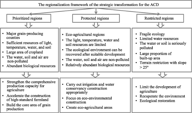
Figure 1 The regionalization framework of strategic transformation for Ningxia Agricultural Comprehensive Development (ACD)

3 Regionalization process and index system

3.1 Regionalization process

The technical route for the strategic transformation of regionalization for Ningxia is shown in Figure 2. (I) The index system, including temperature, water, soil, and other natural resources in Ningxia, was established; (II) The suitability levels of these indices for agricultural production were evaluated according to the spatial distribution of cropland, high standard farmland, high-yield fields, ACD projected areas, the plan of high-standard farmland in Ningxia for 2020, etc.; (III) The necessary conditions for prioritized, protected, and restricted regions were determined by the evaluation of each index; (IV) According to the suitability levels of different indices from III, the limiting indices and the levels for the agricultural development in Ningxia were identified; (V) Index thresholds for the suitable and limiting conditions in the prioritized regions, protected regions, and restricted regions were established; (VI) A percentage area of each index of the suitable and limiting thresholds were calculated at a township scale; (VII) The criteria of the three regions were defined according to the spatial distribution of each index threshold in each township, and the regionalization types were classified according to the criteria.
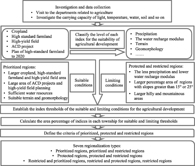
Figure 2 The technical route for strategic transformation of regionalization for Ningxia Agricultural Comprehensive Development
In general, the regionalization types are transitional, gradual, or mixed due to the complexity and non-uniformity in each township. If the characters of two types are typical in one township, then the two types are named as a mixed type. There are seven types in our regionalization: prioritized regions, prioritized and restricted regions, protected regions, protected and restricted regions, restricted and prioritized regions, restricted and protected regions, as well as restricted regions.

3.2 Index system of regionalization

The indices related to the sustainable and limiting conditions for the ACD were selected as an important basis for dividing regionalization types and subtypes. The indices were considered in combinations of dynamic and static, qualitative and quantitative, and agricultural and ecological factors. There were seven types of indices: cropland, water resources, climate, terrain, landform, ACD projects, and ecological planning. For cropland, the percentage areas of cropland, basic farmland, and high-yielding fields in each township were selected to represent the proportion of cropland or high-quality cropland. For water resources, the percentage areas with a recharge modulus of greater than 200,000 m3/(a·km2) or lower than 10,000 m3/(a·km2) were used to represent the volume of water resources used for agricultural irrigation. For climate, we chose the percentage area with precipitation lower than 200 mm to represent the amount of precipitation. For terrain, we selected percentage areas above 15° or 25° slope to represent the limiting factor of the terrain. For geomorphology, the percentage areas of mountains, hills, and plains were selected in order to analyze the suitability of the ACD. For distribution of the ACD projects, the percentage areas of high-standard farmland projects and the planning projects to 2020 represent developed levels in the past and future. For ecological planning, the percentage area devoted to agriculture-related functions was selected as being representative of agricultural importance. The specific data sources for each index are shown in Table 1.
Table 1 The index system of the strategic transformation of regionalization for Ningxia Agricultural Comprehensive Development

4 Results and analysis

4.1 Naming rules

There are three basic regionalization types (prioritized regions, protected regions, and restricted regions) and four transitional types (prioritized and restricted regions, protected and restricted regions, restricted and prioritized regions, as well as restricted and protected regions). Roman numerals are used in the type names, such as “I prioritized regions”, “II prioritized and restricted regions”, and so on.
The names of the subtypes reflect not only the seven major types of regionalization but also the ecological location of the division unit, such as “IV1 the protected regions with water-saving irrigation pumped from the Yellow River and the restricted regions with soil erosion”, or “VII5 restricted regions returning cropland to grassland”, and so on. In addition, if the region had an obvious regional feature, we named the region according to the sequential geographic location, ecological zone, and development type; for example, “I1 the prioritized regions with paddy- dryland rotations in the south of Yinchuan”, “V1 the restricted regions with forest and grass on Helan Mountain, and the prioritized regions with irrigated dryland in the north of Yinchuan”, and so on.

4.2 Regionalization types

The distribution of the seven regionalization types, including prioritized regions, prioritized and restricted regions, protected regions, protected and restricted regions, restricted and prioritized regions, restricted and protected regions, and restricted regions, is shown in Figure 3 and Table 2. There are 44, 3, 23, 5, 17, 83, and 20 townships in the seven types, respectively.
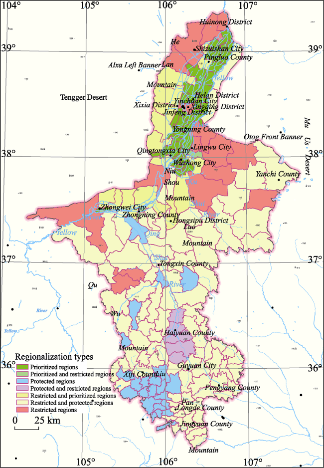
Figure 3 The spatial distribution of regionalization types for strategic transformation of Ningxia Agricultural Comprehensive Development
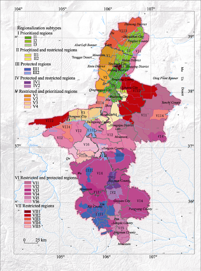
Table 2 The scheme for strategic transformation of regionalization for Ningxia Agricultural Comprehensive Development
Types Subtypes
I The prioritized
regions
I1 The prioritized regions with paddy-dryland rotations in south Yinchuan
I2 The prioritized regions with dryland in north Yinchuan and farmland with pumping irrigation in Taole
I3 The prioritized regions irrigated with water-saving reform in the Weining Plain
II The prioritized and restricted regions II1 The prioritized regions with paddy-dryland rotations in south Yinchuan, and the
restricted regions with sand prevention and control
II2 The prioritized and restricted regions irrigated with water-saving reform in the Weining Plain
III The protected
regions
III1 The protected regions with soil erosion and water-saving irrigation in the valley
III2 The protected regions with water-saving irrigation pumped from the Yellow River
IV The protected and restricted regions IV1 The protected regions with water-saving irrigation pumped from the Yellow River and the restricted regions with soil erosion
IV2 The protected regions with grass-crop rotations, and the restricted regions with forest and grass
V The restricted and prioritized regions V1 The restricted regions with forest and grass on Helan Mountain, and the prioritized regions with irrigated dryland in north Yinchuan
V2 The restricted regions with forest and grass on Helan Mountain, and the prioritized regions with paddy-dryland rotations in south Yinchuan
V3 The restricted regions with desert and semi-desert, and the prioritized regions with irrigation water-saving transformation
V4 The restricted and the prioritized regions of desert steppe
VI The restricted and protected regions VI1 The restricted and protected regions with sand prevention and control
VI2 The restricted and protected regions with desert steppe
VI3 The restricted and protected regions with forest and grass
VI4 The restricted and protected regions with soil erosion
VI5 The restricted and protected regions with water conservation
VI6 The restricted and protected regions returning cropland to grassland
VII The restricted
regions
VII1 The restricted regions with urban construction
VII2 The restricted regions with sand prevention and control
VII3 The restricted regions with forest and grass on Helan Mountain
VII4 The restricted regions with desert steppe
VII5 The restricted regions being returned from cropland to grassland

4.3 Regionalization subtypes

We further divided the 24 subtypes based on the seven types of regionalization (Figure 4 and Table 2). The prioritized regions, as well as the prioritized and restricted regions, are mainly located in the irrigated area of north Ningxia. (I) The prioritized regions include: (I1) the prioritized regions with paddy-dryland rotations in south Yinchuan, (I2) the prioritized regions with dryland in north Yinchuan and farmland with pumping irrigation in Taole, and (I3) the prioritized regions irrigated with water-saving reform in the Weining Plain. (II) The prioritized and restricted regions include: (II1) the prioritized regions with paddy-dryland rotations in south Yinchuan, and the restricted regions with sand prevention and control, and (II2) the prioritized and restricted regions with irrigated water-saving reform in the Weining Plain.
Figure 4 The spatial distribution of the regionalization subtypes of the strategy transformation for Ningxia Agricultural Comprehensive Development
The protected regions, as well as the protected and restricted regions, are mainly located in the loess hilly area of southern Ningxia, including the ecological zone of water-saving irrigation farmland using water pumped from the Yellow River, and the ecological function regions of soil erosion control, and forest and grass protection, as well as of water and soil loss. In addition, the protected regions are also distributed within the ecological region of water-saving irrigation farmland that receives pumping from the Yellow River, in the arid area of central Ningxia. (III) The protected regions include: (III1) the protected regions with soil erosion and water-saving irrigation in the valley, and (III2) the protected regions with water-saving irrigation pumped from the Yellow River. (IV) The protected and restricted regions include: (IV1) the protected regions with water-saving irrigation pumped from the Yellow River and the restricted regions with soil erosion, and (IV2) the protected regions with grass-crop rotations, and the restricted regions with forest and grass.
The restricted regions, restricted and prioritized regions, and restricted and protected regions are mainly located in the north of Helan Mountain, in most areas of the arid zone in central Ningxia, and in the loess hilly regions in southern Ningxia. (V) The restricted and prioritized regions include: (V1) the restricted regions with forest and grass on Helan Mountain, and the prioritized regions with irrigated dryland in north Yinchuan, (V2) the restricted regions with forest and grass on the Helan Mountain, and the prioritized regions with paddy-dryland rotations in south Yinchuan, (V3) the restricted regions with desert and semi-desert, and the prioritized regions with irrigation water-saving transformation, and (V4) the restricted and the prioritized regions of desert steppe. (VI) The restricted and protected regions include: (VI1) those with sand prevention and control, (VI2) those with desert steppe, (VI3) those with forest and grass, (VI4) those with soil erosion, (VI5) those with water conservation, and (VI6) those being returned from cropland to grassland. (VII) The restricted regions include: (VII1) those with urban buildings, (VII2) those with sand prevention and control, (VII3) those with forest and grass on Helan Mountain, (VII4) those with desert steppe, and (VII5) those being returned from cropland to grassland.

5 Suggestions on different development regions for ACD in Ningxia

The irrigated area in northern Ningxia is mainly distributed to the east of Helan Mountain, in the Yellow River irrigation district, Taole plateau, several ditches on the left-hand side of the Yellow River, and the inland region of Gantang. This is the prioritized and essential agricultural development region. There are 43, three, and nine townships belonging to the prioritized regions, prioritized and restricted regions, and restricted and prioritized regions, respectively, accounting for more than 87% of the townships. In addition, there are seven townships belonging to the restricted regions and one township belonging to restricted and protected regions. These regions should continue to implement the modern agricultural projects of “one county-one character”, high-standard farmland, and so on. In order to create high-quality modern agricultural areas, regional governors should accelerate the application of information technology, and promote the construction of production bases for high- quality agricultural products such as green and organic foods. The advantages of location, information, market, science, and technology should be given full play, and modern agricultural ideas such as organic agriculture, intensive agriculture, precision agriculture, and high-value agriculture should be practiced in these regions. The aims are (i) to realize a high-quality, high-yield, high-efficiency system delivering high-value grain and other agricultural products, and (ii) to build a modern agricultural system with industries including high-quality grain, wolfberry, grape, dairy, and fisheries.
The arid area in central Ningxia is on the south of the region in northern Ningxia irrigated by the Yellow River, on the north of the loess hilly and gully region, on the west of the Mu Us Desert, and on the southeast of the Tengger Desert. Eighty-one percent of townships are situated in restricted or protected regions, and the others are in the restricted and prioritized regions, or the prioritized regions. The most serious problems in this area include scarce water resources, fragile ecology, poor quality of farmland, and natural disasters. In this region, we should continue to support the projects of “one county-one character”, water-saving, and ecological control; however, projects promoting high-standard farmland should be reduced. High-quality animal husbandry products should be developed in this region. Further, the water resources should be used rationally and the project patterns should be planned according to the distribution of water resources. For ecological control, efforts should be made to improve the ecosystem service function of sand prevention and control, as well as that of grassland maintenance.
The loess hilly area in southern Ningxia is located in the loess hilly and gully area and in parts of the Liupan Mountain. All townships in this region are in protected regions or restricted regions, including 58 restricted and protected regions, 21 protected regions, and five protected and restricted regions. Population overload, vegetation degradation, and soil and water loss are the most serious problems in this region. The main restrictive factors to agricultural production are the serious shortage of water resources, weak infrastructure, poor ability to resist natural disasters and low and unstable grain yields. In the protected regions, we should focus on building eco-agricultural regions on the northwest Loess Plateau, including the introduction of ecological agriculture in southern mountainous areas and the development of grass, livestock, and potato industries.

6 Conclusions

The strategic transformation of regionalization for the ACD is a basic development plan; to encourage sustainable development and improve competitiveness. This research is the first attempt at strategic transformation of regionalization for the ACD following the scientific classification of prioritized regions, protected regions, and restricted regions as presented by the Ministry of Finance of the People’s Republic of China.
We took Ningxia as an example to study the principles and methods of strategic transformation of regionalization for the ACD, and presented multi-dimensional indices that are dynamic and static, qualitative and quantitative, agricultural and ecological. The type classification varies from pure types of agricultural regionalization to transitional types that achieve the goals of both sustainable agriculture and ecological protection.
This research is the first strategic transformation of regionalization for the ACD at a township (town) scale in a province or an autonomous region. This regionalization is convenient for the governors of the national and provincial ACD offices, and it can be used in enquiries, analysis, plotting, management, evaluation, and decision-making.
The results could provide an important basis for spatial planning and the implementation of strategic transformation of regionalization for the ACD in the future. Meanwhile, it could also provide an important reference for the strategic transformation of regionalization in other provinces or regions.
Some aspects still need improvement. First, we have not considered environmental pollution indices, due to the limited amount of data and the unpolluted water and soil in Ningxia. However, indices of environmental pollution should be considered, especially in other polluted regions. Second, the process of implementing regionalization should be applied step-by-step according to local conditions, and should determine the direction and focus for sustainable agricultural development in different ecological regions. Regionalization can provide a scientific basis for adjusting the plan for the ACD and for promoting the sustainable development of agriculture.

The authors have declared that no competing interests exist.

1
Agricultural Regionalization Research Team of Geographical Society of China, 1965. The New Delelopment of Agricultural Regionalization in China, 1965.Acta Geographica Sinica, 31(4): 269-276. (in Chinese)

2
Chen Xiaohong, Wang Yujuan, Wan Luhe et al., 2012. Study on the eco-agriculture regionalization based on hierarchical cluster analysis in Northeast China.Economic Geography, 32(1): 137-140. (in Chinese)Agriculture system is an open multiple system compound by ecology-economy-society system which has dissipation structure.Agricultural regionalization is necessary for agriculture development because it must be taken measures suited to local conditions.Based on the principle of ecological agriculture regionalization and the warrant established to it,the index system of regionalization is radiated.At last,the Northeast is divided into six big ecological agriculture construction areas which concludes fourteen second eco-regions.

3
Deng Jingzhong, 1960. The Research Methodology of Agricultural Regionalization in China. Beijing: Science Press. (in Chinese)正正确地进行农业区划,对于合理配置农业生产,加速农业生产的发展有着重大作用。因为只有拟定有科学根据的正确的农业区划方案,才能更好地根据国家统一计划的要求和因地制宜的原则,在地区和地区间、公社和公社间实行合理的劳

4
Deng Jingzhong, 1982. Some problems on the comprehensive agricultural regionalization of China.Geographical Research, 1(1): 9-18. (in Chinese)In this paper the author states the main features and necessity of the comprehensive agricultural regionalization, intoduces a scheme of regionalization of the whole of China, and discusses some topics for further investigation.As the comprehensive agricultural reginalization represents the regional similarities and differences of the conditions, peculiarities, potentials, orientations and measures of the development of agricultral production, it plays an indispensable role as a basic scientific means in the agricultural planning and guidance in line with local conditions. The author has worked out a scheme of comprehensive agricultural regionalization of China, which was adopted in 1980 by the Nationwide Committee of Agricultural Regionalization. under the State Agricultural Commission .This paper briefly presents its criteria of demarcation, working processes and system of regionalization.Taking the orientatoin of production and development measures as the key criteria, the author demarcated the country into 10 main agricultural regions and 38 subregions.In order to provide the study of regionalization with more validity and completeness, the author suggests the following topics to be adopted for further study, such as problems on the adjustment of distribution of agricultural production, on the selection and building of commercial production bases of agriculture, the adjustment of the orientation of production in areas destroyed seriously in ecological balance, the rationalizaton of agricultural structures in various regions, field investigations of some important agro-geographical limits, possible patterns and steps to be taken to realize the areali specialization of agriculture in China, etc.

DOI

5
Deng Jingzhong, 1963. The preliminary discussion of national agricultural regionalization.Acta Geographica Sinica, 29(4): 265-280. (in Chinese)

DOI

6
Deng Jingzhong, 1984. Property, tasks and further problems of agricultural regionalization.Chinese Journal of Agricultural Resources and Regional Planning, 1: 57-68. (in Chinese)

DOI

7
Fan J, Li P, 2009. The scientific foundation of major function oriented zoning in China.Journal of Geographical Sciences, 19(5): 515-531.<a name="Abs1"></a>Major function oriented zoning (MFOZ hereafter) is the guideline for optimizing the spatial pattern of regional development in China, which entails both theoretical and methodological innovation in the academic field of economic geography. This study analyzes the basic features of territorial function and puts forward a spatial equilibrium model for regional development for the first time. It argues that there exists a trend of regional convergence in the average value which indicates the comprehensive development status of any region. Based on this finding, the study illustrates that the formation of functional zone should be conducive to the narrowing of regional gap and that free flow of resources between regions is the prerequisite to spatial equilibrium. It also investigates the impact of territorial functional evolution on the process of spatial equilibrium and suggests that the maximization of benefits derived from zoning proposal is interrelative with the method of regional division and the degree of understanding towards the temporal changes of territorial function. Furthermore, this study goes on to examine the scientific foundation of several issues concerning the reconciliation between contradictory functions of development and protection, the selection of indicators and the spatial and temporal features of MFOZ. It is then probes into the rationality of achieving dual goals of efficiency and equality simultaneously through three-dimensional flow and spatial equilibrium. The paper ends with discussions on the position, implementation and coordination of MFOZ from the perspective of institutional arrangements of spatial governance including law, planning and government policy.

DOI

8
Fan Jie, 2015. Draft of major function oriented zoning of China.Acta Geographica Sinica, 70(2): 186-201. (in Chinese)lt;p>Major Function Oriented Zoning (MFOZ) is the blueprint for the future developmnt and protection pattern of China's territory, and has been raised to from major function zones planning to major function zoning strategy and major function zoning institution. From 2004 to 2014, the author organized a series of research projects to compose MFOZ for the country, studied basic theory of regional function and MFOZ technical process, and proposed that space controlling zones of national and provincial scales can be divided into four types: urbanized zones, foodstuff-security zones, ecological safety zones, cultural and natural heritage zones. On this basis, major function zones of county scale should be transferred to optimized, prioritized, restricted, and prohibited zones. In this paper, a regional function identification index system comprising nine quantitative indicators (including water resources, land resources, ecological importance, ecological fragility, environment capacity, disaster risk, economic development level, population concentration and transport superiority) and one qualitative indicator of strategic choice is developed. Based on the single index evaluation, comprehensive evaluation using regional function suitability evaluation index is conducted, aiming at testing several key parameters including lower limit of protection zones and upper limit of development zones at the provincial level. In addition, a planning-oriented zoning method of major function zones is also discussed, which has brought the first MFOZ planning in China. According to the MFOZ caliber, it is forecasted that national spatial development intensity will rise from 3.48% in 2010 to 3.91% in 2020. Furthermore, according to caliber of the provincial integrated MFOZ planning, the area of optimized, prioritized and restricted zones accounts for 1.48%, 13.60% and 84.92%, respectively, and that of urbanized, foodstuff-security and ecological safety zones accounts for 15.08%, 26.11% and 58.81%, respectively. In combination of analyses of development level, resources and environmental carrying status and quality of the people's livelihood, the main characteristics of MFOZ were identified. Through verification, MFOZ draft of national and provincial scales, which is interactively accomplished with "MFOZ Technical Process" put forward by the author, is mostly above 80% identical with what have been forecasted.</p>

DOI

9
Feng Zhiming, Pan Mingqi, Zhang Jing, 2006. Study on zoning of China’s integrated land consolidation.Journal of Natural Resources, 21(1): 45-54. (in Chinese)Based on the comprehensive analysis of the geographical differentiations in China's land resources,its present conditions of exploitation and utilization and the problems resulting from the processes,using some scientific principles and indexes,and combining both the methods of&quot;top down&quot;and&quot;bottom up&quot;we formulate a zoning system for China's integrated land consolidation(CILC)with 11 land consolidation regions and 56 land consolidation sub-regions that covers the whole China at the county level by virtue of technologies such as computer analysis,GIS analysis,etc..The 11 land consolidation regions are:Ⅰ Qinghai-Tibet Plateau Region;Ⅱ Northwestern Arid Region;Ⅲ Middle Reaches of the Yellow River Region;Ⅳ Sichuan-Shannan Basins Region;Ⅴ Yunnan-Guizhou Plateau Region;Ⅵ Northeast Mountains and Plains Region;Ⅶ Northern China Plain Region;Ⅷ Middle and Lower Reaches of the Yangtze River Region;Ⅸ Hilly and Mountainous Area South of the Yangtze River Region;Ⅹ Southeast Coast Region;and Ⅺ Oceanic Region. Based on these conclusions,we've also put forward a preliminary assumption of&quot;Diamond Country Land&quot;for implementation of China's overall planning.And the general principles for regional coordinated development and some policies and suggestions or advises for CILC are given.

DOI

10
Government of the Ningxia Hui Autonomous Region, 2013. Atlas of Economic and Social Development of Ningxia and the Surrounding Neighboring Provinces. Beijing: Surveying and Mapping Press & Sino Maps Press. (in Chinese)This paper studies the formation mechanisms of the pattern of labor force migration in the ethnic minority area, based on a sample of 120 administrative villages in the Ningxia Hui Autonomous Region, and by means of questionnaire investigation and indoor interview. The formation mechanism of the pattern of labor force migration, in essence the decision-making mechanism of the rural labor migration, could be interpreted by two factors, i.e. the motives to migrate, and the condition of migration. The rural labor migration in Ningxia Hui Autonomous Region has its own characteristics. The research shows a tendency that a complex mixture of different motives to migrate is gradually replacing a single economic one; the pursuit of a better cultural and social life has become more important. With respect to the social condition (or the social capital factor) of the fulfillment of rural labor force migration in Ningxia, the help of relatives and friends of rural laborers still serves as the main bridge. The advent and development of rural labor broking, however, has become an important element to promote rural migration in Ningxia. Meanwhile, local governments are also making efforts to accelerate the rural labor migration.

DOI

11
Gu Chaolin, Zhang Xiaoming, Liu Jinyuan et al., 2007. The development spatial regionalization of Yancheng City and relevant consideration.Acta Geographica Sinica, 62(8): 787-798. (in Chinese)<p>In the summary of the 11th Five-Year Plan, land can be spatially divided into four kinds of main function regions, including optimal development region, important development region, restrictive development region, and prohibited development region, which is another innovation in traditional regionalization theory and will better serve national economy and social development. This paper takes the view that main function regionalization commits to solve regional problems, coordinating regional development with scientific viewpoint of development. Hence, theories and approaches of main function regionalization need to be updated from time to time. The paper explores the theories and approaches of main function regionalization through the example of the Coastal Development Spatial Regionalization of Yancheng city. First, comprehensive economic regionalization. Economic regions are divided by using traditional comprehensive economic regionalization theories and approaches to decide approximately the directions of development and distribution of different economic regions. Second, regulatory development regionalization. We consider the function, requirements of landscape and ecological system, contemporary conditions of land use, distribution of radical allusion, pollution in the nearshore area, distribution of seaports, conservative water supply resources, nature reserves and ecological reserves of the comprehensive economic regions above, and decide related prohibited development region and restrictive development region. Third, development potential regionalization. Taking administrative villages and towns as basic units, based on multi-factor analysis, we use the three main factors to make development potential divisions including carrying ability of resources and environment, existing development density and intensity, and future development potentials. Finally, the main function regions are planned on the basis of these three kinds of regionalization. The paper also proposes that a main function region is actually a kind of division of regional development policies, whose regionalization is a mere regional division and a spatial platform for the three kinds of planning &mdash;economic and social development planning, land use planning and urban comprehensive planning&mdash;to integrate together.</p>

12
Hou Xueyu, 1988. Chinese Ecological Regionalization and the Development Strategy of Big Agriculture. Beijing: Science Press. (in Chinese)

13
Huang Bingwei, 1959. China comprehensive natural zoning draft.Chinese Science Bulletin, 18: 594-602. (in Chinese)

14
Ji Yongzan, Yan Huimei, Liu Jiyuan et al., 2015. Spatial distribution pattern of Chinese high-yield, middle-yield and low-yield cultivated based on the MODIS data.Acta Geographica Sinica, 70(5): 766-778. (in Chinese)<p>With the population increase and food consumption upgrade in China, the issue of food self-sufficiency attracts much attention from both Chinese government and international society. Under the circumstances of inadequate cropland resources supply and plenty of cropland occupied by urban construction, improving the utilization efficiency of arable land resources and increasing the cropland productivity have become the fundamental strategies of agricultural development in China. Since 1988, cropland improvement projects (medium-yield and low-yield field improvement and high-standard cropland construction) have been launched and implemented on a large scale, therefore a spatially explicit map for the distribution of high-, medium- and low-yield cropland was essential for cropland improvement planning. In this study, a new method for recognizing high-, medium- and low-yield field is developed based on cropland productivity, which is calculated by using a light use efficiency model and MODIS data with a 500-m resolution. This method can not only reflect the regional heterogeneity of cropland condition, but also express the spatial differences on a grid scale. At the same time, it effectively overcomes the shortage of statistical data based method in a county unit. The results show that the proportion of high-yield, medium-yield and low-yield cropland in China is 20.66%, 39.56% and 39.78%, respectively. About 3/4 of low-yield cropland is located in the hilly and mountainous regions, while 53% of the high-yield cropland is located in plain area. The five provinces with the largest area of high-yield cropland are Henan, Shandong, Jiangsu, Hebei and Anhui, which are all located in the Huang-Huai-Hai region. The sum of the high-yield cropland area in these five provinces accounts for 41.75% of the national total high-yield cropland area. In Heilongjiang province, Sichuan province and Inner Mongolia autonomous region, where the cropland area ranks the top three of China, the proportion of high-yield cropland area in each province only accounts for not more than 15%.</p>

DOI

15
Li Bingyuan, Pan Baotian, Cheng Weiming et al., 2013. Research on geomorphological regionalization of China.Acta Geographica Sinica, 68(3): 291-306. (in Chinese)According to research achievements of Chinese regional geomorphology over nearly 30 years, including landscape classification and landform mapping, this paper systematically discusses the specific steps and methods, principles and the standards for geomorphological regionalization. It is suggested that the basis and standard of geomorphological zoning at all levels not only include the similarities and differences of the combinations of geomorphology type together with the landform genesis, but also its dimension. Based on 1:4000 000 geomorphplogical map of China and the GIS technology, we made an analysis of reasons for the Chinese regional differentiation of the essential geomorphological types and their genesis and divided the whole China into six major geomorphological regions and 38 districts. Region I (eastern hilly plains) is located in the northern part of the low terrain unit of China, in which the largest plain areas of China are distributed. Plains and platforms are dominant and the fluvial accumulation landforms are well developed. This region includes seven districts. Region II (southwestern low-middle mountains) is located in the southern part of the low terrain unit of China, which is dominated by low-elevation hills and low- or middle-relief mountains with only 30% of its area occupied by plain and platforms. Fluvial geomorphologies are typical with a developed karst landform in Southwest China, which can be divided into five districts. Region III (central and northern middle mountains and plateau) is located in the northeastern part of the middle terrain unit of China, characterized by the plateau landform composed of the low- or middle-relief mountains, hills, platforms and plains. Loess landform is well developed. This region includes five districts. Region IV (northwestern middle and high mountains and basins) is located in the northwestern part of the middle terrain unit of China. It is composed of middle to high mountains interposed by flattened basins and is characterized by arid desert geomorphology, where mountains with basins are made up of plains, platforms and hills. This region can be divided into five districts. Region V (southwestern subalpine mountains) is located in the southern part of the middle terrain unit. With a typical karst landform, middle or high mountains with middle or high reliefs are widespread and are scattered by wide valley basins. This region includes five districts. Region VI (Tibetan Plateau) covers the high terrain unit of China. It is composed of plains and high mountains with elevations higher than 4000 m and 3/4 area of the region, and is characterized by glacier and periglacial landforms. This region can be divided into nine districts.

16
Lin Chao, 1954. Outline of physical geography regionalization in China.Acta Geographica Sinica, 20(4): 395-418. (in Chinese)

17
Liu Y, Zhang Y, Guo L, 2010. Towards realistic assessment of cultivated land quality in an ecologically fragile environment: A satellite imagery-based approach.Applied Geography, 30(2): 271-281.<h2 class="secHeading" id="section_abstract">Abstract</h2><p id="">It is very difficult to realistically assess cultivated land quality (CLQ) because its contributing factors cannot be accurately quantified. This study aims at overcoming this difficulty by using information objectively derivable from ETM+ and SPOT images for Hengshan County, Northwest China. This objective approach is able to yield a comprehensive CLQ assessment using five proposed indicators. They are slope gradient, proportion of sandy land, water availability, soil fertility, and land use types organized into three indices of pressure resistance, land state, and land use response. Therefore, this assessment takes into consideration topographic setting, land degradation risk, moisture, vegetation growing condition, and land use response of farmers. The developed CLQ is found to be significantly correlated with the spatial distribution of water resources, suggesting that water availability is a decisive factor influencing land productivity. CLQ is also correlated closely with rural economic level, agricultural infrastructure investment, and the farming system. The whole County was further classified into three cultivated land use zones based on the calculated CLQ value. Each zone is best used for different purposes and requires different strategies of protection. Such assessment outcomes are essential for the prevention of land degradation and adjustment of agricultural structure to promote sustainable use of cultivated land.</p>

DOI

18
Liu Yanhua, Zheng Du, Ge Quansheng et al., 2005. Problems on the research of comprehensive regionalization in China.Geographical Research, 24(3): 321-329. (in Chinese)The modern regionalization in China has attained plentiful and substantial achievements in recent 50 years and has made important contributions to the socio-economic construction. Meanwhile, great changes have taken place in the natural and socio-economic patterns in China. So it is indispensiable to develop comprehensive regionalization as the basis of the sustainable socio-economic development for China. The main scientific issues to be discussed are as follows: 1) the target of service and the mission of research; 2) the theory and system of comprehensive regionalization; 3) the changing processes, patterns and their interactions of the main elements in regional system; 4) the identification of the boundaries between the regional systems in China; 5) the identification of typical regions and the analysis on their characteristics; 6) the interaction between the global geographical patterns and the comprehensive regional system in China; 7) data mining, processing and dimensioning; 8) the integrative methodology of comprehensive regionalization; 9) scenario analysis for the future evolution of regional system in China; and 10) the dynamic demonstration system for the comprehensive regionalization.

DOI

19
Liu Yuying, Shi Daming, Hu Yixin et al., 2013. Risk analysis and regionalization of agrometeorological drought hazard in Jilin Province of Northeast China.Chinese Journal of Ecology, 32(6): 1518-1524. (in Chinese)<div style="line-height: 150%">Based on the 1961-2010 observation data from 50 meteorological stations and the 1981-2010 drought disasters&rsquo; and agricultural economic data, and by using the theories of natural disasters systematic analysis as well as the methods of farmland water balance and disaster risk index, this paper analyzed the dangers of drought hazardcausing factors to agricultural production, the sensitivity of drought hazard-formative environments, the vulnerability of drought hazard-affected bodies, and the capability of drought prevention and disaster mitigation in Jilin Province of Northeast China. The comprehensive risk indices of different units were obtained by using the weighting comprehensive evaluation method, and the drought hazard affecting the agricultural production of the Province was spatially regionalized based on GIS technology. In the Province, the high risk region of drought disaster-causing factors was distributed in the Baicheng and most areas of Songyuan in western Jilin, the high sensitivity region of drought hazardformative environments was distributed in the areas of Baicheng, Songyuan, north of Siping, and south of Tonghua, the high vulnerability region of drought hazard-affected bodies was distributed in the economically more developed areas, including the most parts of Songyuan and Changchun, and Siping, and the region with high capacity of drought prevention and disaster mitigation was mainly distributed in Songyuan, Changchun, Siping, Jilin City, and Tonghua urban area and its surrounding areas. In considering the integrated risk level of all the drought hazard-causing factors, the drought risk affecting the agricultural production of Jilin Province could be classified into 5 levels, i.e., high, sub-high, medium, sub-low, and low, among which, high and sub-high risks&nbsp; mainly occurred in the regions of Baicheng, Songyuan, Changchun, and Siping.</div><div style="line-height: 150%">&nbsp;</div>

20
Lv Xiaofang, Wang Yanglin, Zhang Yili et al., 2007. Research on agricultural functions regionalization and sustainable development strategy of ecologically vulnerable environment in the west of China: A case of Yanchi county in Ningxia Hui Autonomous Region.Journal of Natural Resources, 22(2): 177-184. (in Chinese)The ecological condition of agriculture in the west of China is extremely fragile and there exists the potential of a series of problems,such as severe desertification,environmental degradation.Meanwhile,its social and economic basis is relatively weak,especially in the typical agricultural regions.How can we not only realize agricultural industrialization and agricultural specialization in the fragile regions,but also combat the environmental problems in the process of their agricultural production,then develop sustainable economic system in local regions?芽It is necessary to make the functional regionalization of agricultural resources and environment ahead of schedule.Based on the sustainable idea and the eco-economical-system theory,this paper explores indexes of the agricultural-functional regionalization in Yanchi County,which is a typical agricultural county in central Ningxia Hui Autonomous Region.The paper combines mathematics-ecology models with clustering analysis models of statistics to make the agricultural-functional regionalization of the county.On the basis of physiographical regionalization,it adds the principal components analysis of social and economic indexes,which come from the analytic function models of SPSS and include four typical elements reflecting the standard of agricultural production profit,the population pressure,the population increasing rate and the standard of non-agriculture of each village respectively.The final result of agricultural-functional regionalization includes five agricultural-functional sub-regions: 1) the grain-economic-crop-wood-stockbreeding-medicine eco-economic region in the upland of northern part of the county,which consists of five villages,and its function should be focused on developing byproducts to meet the demand of good market condition while preventing desertification;2) the stockbreeding-wood-grassland-grain eco-economic region in sandy upland and bottom land,which consists of four villages,and its function should be focused on raising sheep while seeding degenerated pasture;3) the grain-oil-economic crop-stockbreeding-special local product region in the sandy bottomland which consists of two villages,and its function should be focused on developing special local farm products of food and oil plants while paying more attention to local salina;4) the grain-economic crop-fruit-vegetable-stockbreeding region in the upland and bottom land of Dashuikeng town,and its function should be focused on the economic product,such as fruit and vegetables while protecting drainage area in the south;and 5) the grain-oil-special local product-fruit-stockbreeding region in the upland and low mountain area which consists of four villages,and its function should be focused on planting oil plants and pasture of high quality while conserving soil and water in the loess upland.Through analyzing eco-economic characteristics of these regions,the paper proposes the sustainable development strategy for each region.

DOI

21
Miao Bailing, Hou Qiong, Liang Cunzhu, 2015. Agricultural climate regionalization of dryland farming for potato in Yinshan based on GIS.Chinese Journal of Applied Ecology, 26(1): 278-282. (in Chinese)<div style="line-height: 150%">Based on the meteorology dataset of 34 stations over the Yinshan area through the recent 30 years (1982-2010), we investigated the key environmental variables influencing potato yield using the correlation and regression methods. Two environmental variables, including the mean temperature difference, precipitation during the growing season, were selected as the major indexes for determining the suitable area for planting potato. Using the GISbased small grid calculation model, we interpolated these two major environmental variables and produced the climatic map for potato in Yinshan area.The results showed the high potato yield area located in Qianshan and southern Houshan, and the mediumyield division was mainly concentrated in the central Houshan and northwest Qianshan, the lowyield division was distributed mainly in northern Yinshan. Moreover, this study examined the spatial patterns of potato production, and evaluated the stability of potato yield by combining the relative variability of potato yield. This study could provide valuable references for planting potato in Yinshan area.</div><div style="line-height: 150%">&nbsp;</div>

22
Ren Mei’e, Yang Renzhang, 1961. Problems on the research of natural regionalization in China.Acta Geographica Sinica, 27(1): 66-74. (in Chinese)

23
Tao Hongjun, Chen Tizhu, 2014. Literature review on agricultural regionalization theory and practice research. Chinese Journal of Agricultural Resources and Regional Planning, 35(2): 59-66. The Agricultural Regionalization Research Team of Geographical Society of China.This paper discussed the research progress of agricultural regionalization theory and practice at home and abroad. It concluded that agricultural regionalization work in developed countries,like the United States, France and Japan,had experienced a long process of development,and formed a relatively mature theory and method system as well as specific experiences and practices. Since the 1950s,core issues like connotation,research object,disciplinary nature and characteristics,theoretical basis,research methods,content and innovative ideas on China's agricultural regionalization work had attracted many scholars' attention and discussion. And it had initially formed a relatively complete theoretical system. In practice,the work of China's agricultural regionalization had achieved initial success. for example,the regional distribution of agriculture has been optimized,the producing areas of the advantaged agricultural products had been further concentrated,and the industrial belt of the characteristic agricultural products has been initially formed. But problems like similar regional structure,regional development imbalances and low level of industrialization of agriculture still existed. In future,China's agricultural regionalization work should focus on solving the " three rural issues",using the combination of qualitative and quantitative dynamic method and playing a further important role in multifunctional agriculture expansion and integrated and coordinated development between industry and agriculture,urban and rural,citizens and farmers.

24
The Second Land Survey of Ningxia Hui Autonomous Region Atlas Compilation Committee, 2012. The Second Land Survey of Ningxia Hui Autonomous Region Atlas. Beijing: Surveying and Mapping Press & Sino Maps Press.

25
Wang Chuansheng, Zhao Haiying, Sun Guiyan et al., 2010. Function zoning of development optimized area at a county level: A case study of Shangyu, Zhejiang.Geographical Research, 29(3): 481-490. (in Chinese)The "Eleventh Five-year Plan" divides national functional zones into the basic unit of county administrative division,which is called major function oriented zoning(MFOZ).According to general disposition of national MFOZ,central and provincial governments are implementing MFOZ strategy in the unit of county administrative division.After prefectural and county level governments have implemented national MFOZ,the spatial development sequence should be specified,the development intensity should be limited,oriented zones should be designated and the "red line" areas of spatial governance should be made definite.In the view of the above,choosing a typical county area and exploring its functional oriented zoning,its major function will play a big role in the national's spatial planning in "the Twelfth Five-year Period",and it will provide experience to study the functional oriented zoning which is the theme of MFOZ for the present academic circles. The paper takes Shangyu as an example to study general principles,the train of thought and index system of county area functional oriented zoning.The oriented function zones of Shangyu should follow five principles,which are general principles of development-optimized county area:(1) area extropism;(2) based on population and industry spatial combined pattern;(3) spatial rational regulation and control,and intensive usage of land resources;(4) ecological preservation and construction of areas' integrality;(5) areas relatively concentrated and give consideration to town administrative units.Oriented function zones are classified into two levels: the first level is fundamental zones to make clear next level's development,as well as to adjust and restrict areas' development limits.The basic unit is town and the final result covers the whole county areas.The second level is zones to implement regional policies.The basic unit is natural landscape or plot,and the result does not cover the whole areas. This paper evaluates land development suitability and analyses the spatial distribution of major natural and human factors.On this basis,it estimates the rational value of Shangyu land development intensity according to the arrangment of national MFOZ.Furthermore this paper suggests a functional oriented zoning plan with 2 levels and 4 types.According to land development suitability evaluation of state technological and economic seedtime,the reasonable value of Shangyu land development intensity should not exceed 13%.

DOI

26
Wang Lianxi, Meng Dan, Geng Xiuhua et al., 2013. GIS based drought risk assessment and zoning in Ningxia.Journal of Natural Disasters, 22(5): 213-220. (in Chinese)

27
Wu Shaohong, Liu Weidong, 2005. An integrated approach to classification of territorial system: A case study of Tibetan Plateau.Geographical Research, 24(2): 169-177, 321. (in Chinese)Recent geo-researches display two significant features. First, most research projects are centered on revealing the implications for regional sustainable development and ecological security; and second, these projects try to employ an integrated approach to taking both physical and socio-economic factors into consideration. Indeed, the implementation of sustainable development strategy demands a classification of territorial systems based on such an integrated approach. To be integrated, a key scientific issue is how to synthesize the physical and socio-economic factors in the process of classification. Based on a new indicator system, which involves mainly physical indicators at the macro level and socio-economic indicators at micro level while employing both at the middle level, this paper tries to develop a new integrated approach to the classification of territorial systems to reveal the features of human-nature relationship at various spatial levels. The new system of classification is a hierarchy consisting of five levels: class zero realm; class one ecological zone (and/or) sub-zone; class two land-human region; class three eco-economic division; and class four economic districts. The classification at the first three levels is a "top-down" process; that at the fifth level is a "bottom-up" process; and that at the fourth level is a matching process from both the top and the bottom. The paper further tests the new approach of classification via a case study of the Tibetan Plateau. By the approach, the Plateau is divided into 3 zones, 15 regions, 22 divisions and 29 districts. Such classification results have profound implications for regional sustainable development.

DOI

28
Xie Gaodi, Zhang Changshun, Zhang Linbo et al., 2012. China’s country-scale ecological regionalization.Journal of Natural Resources, 27(1): 154-162. (in Chinese)Three-level zoning system of domain-ecoregion-ecodistrict and top-down division method were adopted, and four domains (i.e., the northeast humid and semi-humid domain, the northern arid and semi-arid domain, the southern humid domain and the Tibet Plateau domain), 11 ecoregions and 63 ecodistricts were identified in China according to quantitative and qualitative indicators (e.g., climate, topography, ecosystem characteristics). Because this scheme pays more attention to the application of the usual name in ecoregion naming, and keeps the integrity of county border, it not only provides scientific basis for protecting, constructing and evaluating national eco-environment, but also makes eco-environmental data better integrated with socio-economic data at county scale, hence leading to more effective ecosystem management, recognizing the position of regional ecological functions and guaranteeing regional eco-security, so as to provide a scientific basis for strategic decision-making, ecological resources conservation, eco-environmental protection and construction at national or regional scale.

DOI

29
Xu Jitian, Chen Baiming, Zhang Xueqin, 2001. Ecosystem productivity regionalization of China.Acta Geographica Sinica, 56(4): 401-408. (in Chinese)The regionalization of ecosystem productivity in China is the process and result of dividing China into different regions according to the difference and likelihood of biota productivity. The ecosystem productivity region considers the modern topographic delineation and its macro control on the formation of ecosystem landscape characteristics and the influences of monsoon climate and the differentiation of ecosystems caused by light, temperature, water, and other conditions. The productivity zone firstly considers different ecosystem types and their combination characteristics, and then considers difference of ecosystem productivity for different types (e.g., farmland, forest and grassland). According to the value of comprehensive ecosystem productivity for each productivity zone in China, the comprehensive ecosystem productivity of China is divided into 5 grades. Finally, the regionalization divides the whole country into 12 first level ecosystem productivity regions, and 64 second level ecosystem productivity zones.It can be seen clearly from the regionalization that the grade distribution of ecosystem productivity of China is stepwise, which correlates well with the three steps of China's topographic profiles. The regionalization also indicates that the level of farmland ecosystem productivity can well evaluate the level of ecosystem productivity for most parts of China (i.e., 46 zones). However, for the rest of China (i.e., 18 zones), there exists sharp difference between the level of farmland ecosystem productivity and ecosystem productivity because of the imbalance of regional development.

30
Zhao Songqiao, 1983. A new scheme for comprehensive physical regionalization.Acta Geographica Sinica, 38(1): 1-10. (in Chinese)

31
Zhao Yan, Wang Zhiguo, Sun Baoping et al., 2013. A primary study on scheme of soil and water conservation regionalization in China.Acta Geographica Sinica, 68(3): 307-317. (in Chinese)Regionalization of soil and water conservation is the basis for the planning of soil and water conservation in China. It can provide scientific basis for constructing healthy ecological environments and regional management and development. It makes a brief review of related regionalization of study and makes clear the concept of regionalization of soil and water conservation. In this paper, based on synthetical analysis of the characteristics of ecological environments of China, the principles, indices and nomenclature of the regionalization of soil and water conservation are proposed. Through the construction of the regionalization of soil and water conservation collaboration platform and data reporting system, combined with the existing soil and water conservation research, this paper uses the top-down and bottom-up and the combination of qualitative and quantitative methods to build soil and water conservation regionalization preliminary scheme, with 8 regions, 41 subregions and 117 sections divided across the country.

32
Zheng Du, Ou Yang, Zhou Chenghu, 2008. Understanding of and thinking over geographical regionalization methodology.Acta Geographica Sinica, 63(6): 563-573. (in Chinese)lt;p>As a radical method in geographical research, geographical regionalization has been widely used by geographers in their works, even since earlier times. But there are few documents devoted to the discussion of the geographical regionalization itself. The present article tries to probe into its connotation and contents of the geographical regionalization in the context of a methodology. As is well known, there exist similarities and dissimilarities among the geographical zones, and zonality is a universal theorem governing geographical distribution. Therefore, geographical regionalization exists objectively, and geographers just try to develop and construct an image of geographical realities. At the level of concept, geographical regionalization can be referred to a draft of regional division which meets some practical purposes, or a process a dividing region which adopts certain indexes and uses some techniques to divide an area (region) into many inter-related sub-areas (sub-regions), or a method to reveal the laws hidden in various geographical phenomena. As a draft, map-based form is a good way to describe the distribution of geographical features and phenomena. Clustering and classification are usually used in the process of regionalization in traditional physical regionalization. But these methods have little consideration of temporal variation of the geographical features. On the basis of analysis of the various regionalization drafts and plans, we proposed a scheme composed of five elements for geographical regionalization. Any regionalization must start from the understanding of the regionalization ontology composed of objects and aims and tasks of a geographical regionalization. The principles and criteria are the bases for the geographical regionalization and should be carefully designed and selected to fully meet the needs of the regionalization. Regionalization models include the model for dividing an area and determining the boundaries among the sub-areas. Regionalization information system stores the attributes of all sub-areas and provides the functions for assessing and simulating the draft of a geographical regionalization.</p>

DOI

33
Zheng Jingyun, Yin Yunhe, Li Bingyuan, 2010. A new scheme for climate regionalization in China.Acta Geographica Sinica, 65(1): 3-12. (in Chinese)lt;p>A new scheme for climate regionalization in China was established based on the daily observations for 609 meteorological stations during the period 1971-2000.During regionalization,current basic theories,classification methodologies and criteria system were used,besides,five principles were taken into consideration,mainly included zonal and azonal integration,genetic unity and regional relative consistent climate integration,comprehensiveness and leading factors integration,bottom-up and top-down integration,spatial continuity and small patch omission.The new scheme consists of 12 temperature zones,24 moisture regions and 56 climatic sub-regions.</p>

DOI

34
Zhou Chenghu, Cheng Weiming, Qian Jinkai et al., 2009. Research on the classification system of digital land geomorphology of 1:1000000 in China.Journal of Geo-information Science, 11(6): 707-724. (in Chinese)Geomorphologic classification system is essential to geomorphologic research and mapping.Using the compiling methodology and standard of geomorphologic maps with a scale of 1 1 000 000 in 1980's in China,based on the summarization of geomorphology,classification research at home and abroad,and the technology such as remote sensing image,digital elevation model(DEM) and computer automated cartography and so on,this research concludes and summarizes the principles followed in the classification process of digital geomorphology;analyzes the mutual relations hips among them;discusses various indexes of digital land geomorphologic classification: including morphology,genesis,material composition,age etc.The classification system puts forward numerical classification methodology of 3 classes,6 grades and 7 layers of digital Land geomorphology in China;presents data organization method of digital geomorphology,that is: morphology and genesis types represented by polygon map spot,morphology and structure type represented by point,line and polygon map spot together.Moreover,the article specifically presents the geomorphologic types of different layer and different level of various genesis types.The research of classification system of digital geomorphology provides a basis for the interpretation and cartography of Land geomorphology based on multi-source data such as remote sensing etc.

DOI

35
Zhou Lisan, 1979. The significance of agricultural regionalization and its relationship with agricultural modernization.Soil Fertilizer, (6): 3-7. (in Chinese)

36
Zhou Lisan, 1981. Some problems on the agricultural regionalization.Scientia Geographica Sinica, 1(1): 11-21. (in Chinese)According to the basic characteristics of agricultural production and the objectiveconditions of the agricultural regionalization,this paper has mainly analysed andintroduced the purpose and necessity Of the agricultural regionalization and its system.This system is vertically divided into different grades from country level to countylevel,and horizontally divided into natural regionalization,specializational regiona-lization and complex regionalization.In addition,according to the actual conditionsof China,the paper has stated systematically the basic contents of the agriculturalregionalization and its working method.At the same time,the paper has made ascientific approach to some active problems existing in the agricultural regiona-lization,such as the relationships between agricultural regionalization and agriculturalprogramme,agricultural regionalization and administrative division,agriculturalregionalization and agricultural modernization and present agricultural productivestatus and its long range plan,etc.

37
Zhou Lisan, 1993. Theory and Practice of Agricultural Regionalization in China. Hefei: University of Science and Technology of China Press. (in Chinese)

38
Zhou Lisan, Sun Han, Shen Yuqing, 1981. Comprehensive Agricultural Regionalization of China. Beijing: Agricultural Press. (in Chinese)

39
Zhou Qiye, 1957. Fundamental problems on the division of agricultural regions of China.Acta Geographica Sinica, 23(2): 127-144. (in Chinese)1)Theoretical basis for the division of agricultural regions: In a socialistic country, agriculture forms a part of national economy, every agricultural region being an indispensible constituent in agricultural development of the country and being also an agricultural complex of relatively independent nature which complies principal crops, secondary crops and subsidiary productions. The purpose of division of agricultural regions is for rational solution of the problem of localization and specialization of the agricultural production in national economy. Therefore, we must take consideration of the demand of national eco-nomic development on agricultural production, principles of agricultural localization and specialization and regional conditions of agriculture in order to determine the direction of agricultural specialization of a region and to delimit the boundaries of agricultural regions. The following principles are important for determination of the direction of agricultural specialization of a region: (a)coordination of production and consumption; (b) full utilization of natural conditions; (c)full utilization of original basis of agricultural production; (d)transport conditions of different regions; (e)full utilization of labour resources; (f)rational system of crop rotation to conserve and raise the fertility of soils. (2)Suggestions for working out a scheme of agricultural regions of China: In a country like China, with a great variety of natural and economic conditions, regional specialization of agriculture has important significance for raising agricultural productivity so as to assure a sufficient amount of agricultural products to meet the demand of national economy. In the present stage of econo-mic development of China, with successful progress of national industrialization and socialization of agriculture, it is necessary to carry on research on the division of agricultural regions of the whole country. However, in the present, it is difficult to divide agricultural regions at once, because scheme of the division of economic regions has not been completed, agricultural cooperatives are still in constant development, necessary data are insufficient and directions of agricultural specialization of different regions are far from apparent. Under these conditions, the only practical method is that the Central Government Authorities, using available materials, work out a preliminary scheme of agricultural regions of the 1st order in which the main tasks of agricultural deve-lopment of provinces are pointed out. The Provincial Authorities, basing upon 12 year agricultural development plan of the province, draw a plan of future distribution of principal crops and group hsiens with approximately same direction of agricultural specialization to form agricutural regions of the 2nd order. After that, by the same principles and methods, the hsien authorites can work out plans for the division of agricultural regions of 3rd order which may be used as a guide for county and agricultural cooperative planning. After completion of the division of agricultural regions of the 2nd order, the Central Government Authorities, basing upon agricultural development plan of the whole country and taking in consideration of conditions and characteristics of agricultural development of every region, revise boundaries of the preliminary scheme of agricultural regions of the 1st order and complete an authorized division of agricultural regions of the whole country.

Outlines

/