Orginal Article

Causes and effects of spatial and temporal variations of cold period in Chinese oases between 1960 and 2014

  • CHAI Zhonghua ,
  • LIU Puxing , *
Expand
  • College of Geography and Environmental Science, Northwest Normal University, Lanzhou 730070, China

Author: Chai Zhonghua (1989-), MS Candidate, specialized in arid area environment and the construction of oasis. E-mail:

*Corresponding author: Liu Puxing (1964-), Professor, E-mail:

Received date: 2016-06-28

  Accepted date: 2016-07-29

  Online published: 2016-12-20

Supported by

National Natural Science Foundation of China, No.40961035

The Science and Technology Project of Gansu Province, No.0803RJZA094

The Provincial Key Disciplines of Natural Geography Project of Gansu

Copyright

Journal of Geographical Sciences, All Rights Reserved

Abstract

Based on daily average temperatures and observation data from 74 meteorological stations in Chinese oases, we calculate five-day (pentad) average temperature ≤0℃ for the start and end pentad as well as pentads of cold period using linear regression analysis, nonparametric Mann-Kendall tests, the Morlet wavelet power spectrum, and correlation analysis. We also analyze spatial and temporal variations and their effects on the start and end pentad as well as pentads of cold period in Chinese oases. Results show that over the last 55 years, the start pentad of cold period has been postponed while the end pentad has been advanced. Overall, the pentads have gradually shortened over time at trend rates that are 0.3 p/10a, -0.27 p/10a, and -0.58 p/10a, respectively. Spatial differences are significant, especially for the Qaidam Basin oasis where the start pentad is the earliest, the end pentad is the latest, and the trend of change is most obvious. Mutation points for the start and end pentad as well as pentads of cold period were observed in 1990, 1998, and 1994, respectively. Of these, the start pentad and pentads of cold period show a periodic cycle, related to atmospheric circulation and El Nino events, while the end pentad exhibits a periodic cycle, related to solar activity. The Tibetan Plateau index (TPI), the Asian polar vortex area index (APVAI), and carbon dioxide emissions (CDE) are the main factors affecting cold period in the study area, whereas the South Asian summer monsoon (SASM) index exerts the greatest effect on the Qaidam Basin oasis. The start and end pentad as well as pentads of cold period increase in concert with latitude, longitude, and altitude; in response to these changes, the start pentad is advanced, the end pentad is postponed, and pentads of cold period are gradually extended. Results show that change in latitude is most significant. Overall, the start and end pentad as well as pentads of cold period show clear responses to regional warming, but there are different effects on each.

Cite this article

CHAI Zhonghua , LIU Puxing . Causes and effects of spatial and temporal variations of cold period in Chinese oases between 1960 and 2014[J]. Journal of Geographical Sciences, 2016 , 26(12) : 1647 -1660 . DOI: 10.1007/s11442-016-1350-8

1 Introduction

The Fifth Assessment Report of the Intergovernmental Panel on Climate Change noted that global climate change will reach an unprecedented rate in the 21st century (IPCC, 2013). Extreme weather, including strong precipitation, heat waves, floods and droughts, will increase in frequency, and climate change will have a profound impact on natural ecosystems and socio-economic systems. Changes in climate will lead to sea level rise, ocean acidification, disappearance of the cryosphere, hydrologic cycle disorders, frequent extreme events, loss of biological diversity, and threats to food safety (Solomon et al., 2007; IPCC, 2013). In the context of global warming, unusual large-scale climate phenomena appear frequently, at an increasing rate worldwide, leading to serious impacts on society, economy, human health, and the natural environment (Feng et al., 1985; Ding and Geng, 1998; Changnon et al., 2000). Extreme temperature, for example, has been the focus of a great deal of research attention given the background of climate warming. Research has been focused on the USA and the USSR (Karl et al., 1991), the northeastern United States, Australia and New Zealand (Easterling and Horton, 1997; Plummer et al., 1999), Southeast Asia and the South Pacific (Manton et al., 2001), South Asia (Sheikh et al., 2015), and on the cities of Nis and Belgrade (Serbia) (Milanovic et al., 2015). Several studies have reported that warm extremes are increasing, cold extremes are decreasing, and significant increases in the annual numbers of hot days and warm nights are being seen, with significant decreases in the annual numbers of cool days and cold nights. For example, Alexander et al. (2006) reported that over 70% of sampled global land area has experienced a significant decrease in the annual occurrence of cold nights, coupled with a significant increase in the annual occurrence of warm nights. In China, Ren and Zhai (1998) and Zhai et al. (1999) noted that clear temporal (seasonal) and regional differences exist in extreme temperate trends, while Fu et al. (2011) showed that the frequency of extreme minimum temperatures has decreased throughout the country. In addition, Du et al. (2013) found that while the number of frost and ice days has decreased significantly, the length of the growing season, extra-maximum air temperature, and extra-minimum air temperature have all significantly increased. Wang et al. (2013) and Liu et al. (2013) analyzed extreme temperature events in the Yangtze and Pearl river basins and showed that they corroborate these trends.
Compared with other regions, Chinese oases are more sensitive to global warming. The effect of climate change on oases is complicated but serious and is expected to lead to huge losses. Previous studies have suggested that the changes in climate in northwest China are mainly the result of an increase in extreme low temperatures (Liu et al., 2005). Yang et al. (2006) demonstrated that the frequency and intensity of extreme low temperatures have decreased over a nearly 45-year period, whereas Chen et al. (2012) showed that areas of minimum temperature are located in northern Xinjiang and on the Qinghai Plateau. However, previous research on extreme low temperatures has been based on records of average temperatures, daily minimum temperatures, seasonal average extreme low temperatures, and indexes for extreme low temperatures. No research to date has been conducted on cold period by calculating pentad average temperature ≤0℃. Therefore, applying the 72 pentads division that is standard in climatology, pentad average temperature ≤0℃ are calculated here, data for the start and end pentad as well as pentads of cold period are presented, and spatial and temporal variations and causes are analyzed. The purpose of this paper is thus to provide a scientific basis for the determination of agricultural production and heating periods, and provide references for climate change research. It is hoped that the data presented here will enable the official agencies concerned to deal more effectively with climate change, will develop our scientific understanding of the regional responses to global warming, and will lay the foundations for the study of the evolution of extreme low temperature events across the whole of Central Asia.

2 Data and methods

2.1 Study area

Chinese oases are located in the Eurasian Hinterland, distributed alternately in high mountains and basins. The region of interest covers an area of nearly 1.9×10⁵ km2, and includes six oases in northern Xinjiang, southern Xinjiang, the Hexi Corridor, the Hetao Plain, the Qaidam Basin and Alxa. All of these oases are supplied mainly by mountain snowmelt, with the exception of the oasis on the Hetao Plain. The climate of these areas is dry with a mean annual rainfall less than 200 mm. It is cold in winters, hot in summer, temperature changes are obvious, and both annual and daily temperature ranges are large. Light and heat resources at these oases are also very abundant: solar global radiation is more than 5.04×10⁵ MJ/m2, annual sunshine duration is greater than 2800 h, accumulated temperature ≥10℃ is above 2600℃, and the frost-free period is about 140 days. Brown desert, gray-brown desert, and aeolian sandy soils dominate, and the zonal vegetation is mainly characterized by desert and desert steppe plants (Figure 1).
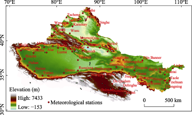
Figure 1 The distribution of meteorological stations in Chinese oases

2.2 Data

A dataset of daily average temperatures for the period between 1960 and 2014 from 74 meteorological observation stations is used in this research, with all data provided by the China Meteorological Science Data-sharing Service System (http://cdc.cma.gov.cn/home.do#). Monthly indices for the time series between 1960 and 2011 were extracted from 74 circulation indices issued by the Laboratory for Climate Studies, China Meteorological Administration National Climate Center and include the TPI, the APVAI, the Asian polar vortex intensity index (APVII), and the Westerly circulation index (WCI). Data for the monthly SASM index for the period 1960 to 2014 were downloaded from Professor Li Jianping’s personal home page (http://ljp.lasg.ac.cn//), while the yearly Siberian high index (SHI) for the same period was provided by Yao Junqiang (Institute of Desert Meteorology, China Meteorological Administration, Urumqi). Annual mean CDE for the period 1960 to 2011 were extracted from the World Bank data center (http://data.worldbank.org.cn/). A linear equation was used to fit sequence variables when changes and trends in the start and end pentad as well as pentads of cold period were analyzed. In order to determine the significance of change trends, we tested the correlation coefficient between time and the original sequence variable (Wei et al., 1999). For mutation tests, we used the nonparametric Mann-Kendall test (Wei et al., 1999), sliding t tests, and the accumulative anomaly method. For Morlet wavelet power spectrum analysis, we used the wavelet analysis toolbox in the Matlab7.0 software.
The data processing method used here follows the standard division of 72 pentads commonly used in climatology to calculate pentad average temperature ≤0℃, and to determine the start and end pentad as well as pentads of cold period.

3 Results

3.1 Temporal variations in cold periods

(1) Inter-annual changes that characterize cold periods
Over the last 55 years, the variations in the start and end pentad as well as pentads of cold period in Chinese oases are extremely significant (Figure 2). Results show that the start pentad has consistently been postponed over this period, at a tendency rate of 0.3 p/10a (α≥0.001). In total, the start pentad has been postponed 1.7 pentads over the past 55 years, starting on average at the 63th pentad, around November 16-20. The earliest the start pentad was in 1981 while the latest was in 1994. In contrast, the end pentad has consistently been advanced, at a tendency rate of -0.27 p/10a (α≥0.001). The end pentad has been advanced 1.5 pentads over the last 55 years, ending on average in the 14th pentad, around March 6-10. The earliest end pentad was in 2013 while the latest was in 1976. It is also worth mentioning that trend towards postponement of the start pentad of cold period is more significant than trend towards advancement of the end pentad; pentads of cold period show a trend towards shortening at a tendency rate of -0.58 p/10a (α≥0.001) and have been decreased by an average of 3.2 pentads over the last 55 years. On average, these periods are 24 pentads in length, with the shortest on record in 2006 and the longest in 1968 (Figure 2). The red line in Figure 2 is the ten-year sliding curve; variation in the start pentad has fluctuated upwards, with an obvious rise after 1994 (Figure 2). In contrast, variations in the end pentad and pentads of cold period are consistent, although both show a downward trend; after 1994, this decline is very obvious.
Figure 2 Trends in inter-annual variation in the start (a) and end pentad (b) as well as pentads of cold period (c) in Chinese oases
(2) Inter-decadal changes that characterize cold periods
In terms of inter-decadal variations in the start and end pentad as well as pentads of cold period in Chinese oases (Table 1), results show that the start pentad exhibits a remarkable trend in postponement with anomaly values that vary from -0.71 (1960s) to -0.26 (1980s) and a postponing of 0.45. Since the 1990s this anomaly value has changed from negative to positive, reaching a maximum value of 0.76 in the period 2010 to 2014. The end pentad also shows a significant trend towards advancement, although this change is not obvious between the 1960s and 1980s. In the 1990s, the anomaly value changed from positive to negative, reverting from -0.14 (1990s) to -0.39 (2010 to 2014), advancing most obviously and reaching a maximum value of -0.9 in the period between 2000 and 2009. Pentads of cold period show significant shortening trends, and the anomaly value varies between 1.17 (1960s) and 0.49 (1980s), a shortening of 0.68. Since the 1990s, this anomaly has changed to negative from a positive value, from -0.34 (1990s) to -1.39 (2010-2014), shortening most obviously between 2000 and 2009. In summary, the start and end pentad as well as pentads of cold period changed most statistically subsequent to the 1990s.
Table 1 Decadal mean anomalies of the start and end pentad as well as pentads of cold period in Chinese oases
Decade Start pentad (p) End pentad (p) Pentads (p)
1960-1969 -0.71 0.34 1.17
1970-1979 -0.25 0.54 0.67
1980-1989 -0.26 0.34 0.49
1990-1999 0.21 -0.14 -0.34
2000-2009 0.61 -0.9 -1.47
2010-2014 0.76 -0.39 -1.39

3.2 Spatial variations in cold periods

In order to better understand the characteristics of spatial variations in the start and end pentad as well as pentads of cold period for Chinese oases, we developed a spatial distribution map for the start and end pentad as well as pentads of cold period using the Kriging method in geographic information system software (Figure 3). This map incorporates time series and tendency rates for the start and end pentad as well as pentads of cold period based on data from the 74 meteorological stations in Chinese oases.
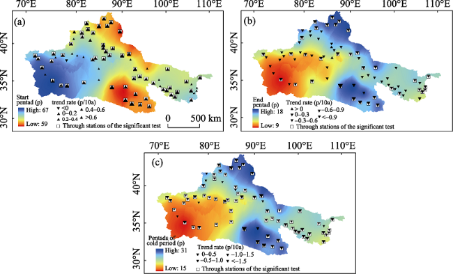
Figure 3 Trends in the spatial distribution of the start (a) and end pentad (b) as well as pentads of cold period (c) in Chinese oases
Results demonstrate that there are remarkable spatial differences across the study area (Figure 3). Considering spatial variations in the start and end pentad as well as pentads of cold period (Figure 3), the start pentad varies from 59 to 67 pentads with a difference of 8 pentads between the highest and the lowest. The cold period in the Qaidam Basin oasis started earliest, in the 60th pentad, whereas this period in the northern Xinjiang oasis started second, in the 62th pentad. The cold period in the southern Xinjiang oasis started last, in the 65th pentad, a difference of 5 pentads between the first and the last. In contrast, the end pentad varies between 9 and 18, and there is a difference of 9 pentads between the highest and the lowest. The cold period in the Qaidam Basin oasis ended latest, in the 17th pentad, whereas in the northern Xinjiang oasis it ended second, in the 16th pentad. The southern Xinjiang oasis has the earliest cold period start, in the 11th pentad, a difference of 6 pentads between the first and the last. Thus, the pentads of cold period vary between 15 and 31, a difference of 16 between the highest and the lowest. The cold period in the Qaidam Basin oasis is the longest, lasting 30 pentads, while that in the northern Xinjiang oasis is second-longest, lasting 28 pentads. In contrast, the southern Xinjiang oasis has the shortest cold period, lasting 19 pentads, an overall difference of 11 pentads.
In terms of spatial variations of the start and end pentad as well as pentads of cold period, the start pentad of 99% of stations are postponed and the rates of changing trend of most stations vary from 0 to 0.4 p/10a. Only the start pentad of the Alar station is advancing, and it does not pass the significance test. Across the whole region, 76% of the stations pass the significance test at the 0.05 level, while the Qaidam Basin oasis shows a more obvious trend towards postponement, averaging 0.48 p/10a. Data show the end pentad of 97% of the stations advanced, at a rate of -0.6 to 0 p/10a for most stations. Urumqi and Kumux stations, however, show postponement and do not pass the significance test. Across the whole region, 47% of stations pass the significant test at the 0.05 level, while the Qaidam Basin oasis is advancing more obviously at a rate of -0.52 p/10a and 75% of stations pass the significance test. The pentads of all stations show a shortening trend, with 89% passing the significance test at the 0.05 level, while rates for most stations vary from -1 to 0 p/10a. The Qaidam Basin oasis is decreasing most obviously at a rate of -0.9 p/10a, while 88% of the stations pass the significance test.
The cold period in the Qaidam Basin oasis starts earliest, ends latest, and is the longest. In addition, the start and end pentad as well as pentads of cold period in this oasis are the most obviously postponed, advanced, and shortened, which suggests that it exhibits most sensitive responses to global climate change. This result is consistent with the conclusion that the climate of this oasis is most sensitive and significant because it is on the Tibetan Plateau (Li et al., 2010); this relates to the observation that it is ‘the driver and amplifier’ of global climate change (Pan and Li, 1996), and the conclusion that the responses to global climate change of high-altitude areas are more sensitive than those of low-altitude areas (Yao et al., 2000).

3.3 Mutation analysis

Climate mutation is not only an important phenomenon in climate change but also an important factor in climate prediction and simulation. Here we used the nonparametric Mann-Kendall test, sliding t tests, and the cumulative anomaly method to analyze abrupt changes in the start and end pentad as well as pentads of cold period in Chinese oases and their subregions over the last 55 years (Table 2). Of these tests, the sequence length of the Mann-Kendall and sliding t test is three years, while the significance level is 0.01 and the critical line is U = ±2.58. Results indicate that over the last 55 years, mutation of the start pentad in the study area occurred in 1990, for the end pentad in 1998, and for pentads of cold period in 1994. Mutation of the start pentad in the subregion occurred in the early 1990s, although this took place slightly earlier in 1991 in the northern Xinjiang oasis. Mutation of the end pentad in the subregion is postponed compared to the start pentad, whereas the Qaidam Basin oasis showed an abrupt change in 1994, the earliest recorded. Mutation of pentads of cold period in the subregion occurred after the 1990s, although the Qaidam Basin oasis again showed the earliest recorded abrupt change in 1993. Mutation of the end pentad and pentads of cold period in the Qaidam Basin oasis were earlier than in other regions, further confirming that this oasis acts as a ‘driver and amplifier’ of global climate change. Mutation of the start and end pentad as well as pentads of cold period in Chinese oases and their subregions all occurred after the 1990s, consistent with the occurrence of subsequent marked warming in China at this time (Lin and Qian, 2003).
Table 2 Mutation analysis of the start and end pentad as well as pentads of cold period in Chinese oases
M-K Sliding t test Cumulative anomaly method
The start pentad Entire region 1990/1991 - 1990
Beijiang 1990/1991 - 1991
Nanjiang 1988 1987/1993 1993
Hexi 1976/1981/1992 - 1992
Hetao 1970/1987/1993 1967/1969/1971 1993
Qaidam - 1993/1994 1993
Alxa 1983/1984/1987 1971/1992 1992
The end pentad Entire region 1998 - 1998
Beijiang 2007/2009/2012 1964/1971/1982 2007
Nanjiang 1997 1984/1997/2010 1995
Hexi 1992/1994/1995 1995 1985
Hetao 1992/1995 1981/1984/1990/1997 1995
Qaidam 1994 1979/1994 1994
Alxa 2007/2010/2012 1969/1989/2007 1990
Pentads Entire region 1994 1971 1994
Beijiang 1999 1970/2006/2007 1999
Nanjiang 1997 1967/1971/1991 1997
Hexi 1995 1971/1972/1995/2007 1995
Hetao 1995/2005/2007/2010 2007 1993
Qaidam - 1993/1996 1993
Alxa 1999 1969/1987/1989/1999 1986

Abbreviations: Beijiang, northern Xinjiang oasis; Nanjiang, southern Xinjiang oasis; Hexi, Hexi Corridor oasis; Hetao, Hetao Plain oasis; Qaidam, Qaidam Basin oasis; Alxa, Alxa oasis.

3.4 Period analysis

We used Morlet wavelet power spectra to analyze changes in terms of the sequence of the start and end pentad as well as pentads of cold period in Chinese oases (Figure 4). Results show that the start pentad has a period of 3.39 years and 4.98 years (α≥0.1), while the end pentad has a period of 8 years and 10.53 years (α≥0.1). Pentads occur with a period of 3.17 years, while the start pentad and pentads of cold period have in common a short period (3-5 years), more in line with the atmospheric circulation period of 2-4 years and the El Nino period of 2-7 years. However, the end pentad has a period of 10.53 years (α≥0.1), which is consistent with the solar activity cycle period of 10.3-11.2 years. Thus, the start pentad and pentads of cold period appear to be mainly impacted by atmospheric circulation and El Nino events, while the end pentad is mainly influenced by solar activity.
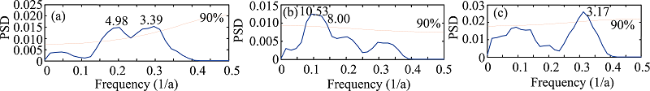
Figure 4 Morlet wavelet power spectra showing the periods of the start (a) and end pentad (b) as well as pentads of cold period (c) in Chinese oases

3.5 Correlation analysis to determine influencing factors

In order to further analyze the factors influencing the start and end pentad as well as pentads of cold period in Chinese oases, correlation coefficients with TPI, APVAI, APVII, WCI, SASM, SHI, and CDE data were calculated (Table 3). Results show that the start and end pentad as well as pentads of cold period are mainly influenced by TPI, APVAI, and CDE. The TPI is positively correlated with the start pentad, with correlation coefficients between 0.26 and 0.392 (α≥0.05), and is negatively correlated with the end pentad and pentads of cold period, with correlation coefficients between -0.525 and -0.219. While APVAI is negatively correlated with the start pentad, with correlation coefficients between -0.578 and -0.218, it is positively correlated with the end and cold period pentads, with correlation coefficients between 0.219 and 0.617. CDE are positively correlated with the start pentad, with correlation coefficients between 0.23 and 0.627, and negatively correlated with the end pentad and pentads of cold period, with correlation coefficients between -0.567 and -0.235.
Table 3 Correlation coefficients for the start and end pentad as well as pentads of cold period in Chinese oases and possible impact factors
TPI APVAI APVII WCI SHI SASM CDE
The start pentad Beijiang 0.26* -0.454** -0.307* 0.213 -0.361** -0.001 0.467**
Nanjiang 0.287* -0.454** -0.41** 0.175 -0.249 -0.123 0.389**
Hexi 0.387** -0.371** -0.21 0.207 -0.327* -0.118 0.422**
Hetao 0.355** -0.288* -0.13 0.178 -0.077 -0.063 0.23
Qaidam 0.339** -0.218 -0.055 0.122 -0.439** -0.345** 0.627**
Alxa 0.392** -0.578** -0.431** 0.186 -0.239 -0.01 0.374**
The end pentad Beijiang -0.23 0.322* 0.247 -0.414** -0.045 -0.145 -0.313*
Nanjiang -0.525** 0.219 0.26* -0.385** -0.1 0.083 -0.389**
Hexi -0.248 0.382** 0.134 -0.235 -0.173 -0.138 -0.259*
Hetao -0.298* 0.302* 0.114 -0.239 -0.105 0.095 -0.235
Qaidam -0.324* 0.308* 0.118 0.05 -0.164 0.297* -0.451**
Alxa -0.241 0.336** 0.436** -0.306* -0.277* -0.138 -0.27*
Pentads Beijiang -0.219 0.617** 0.448** -0.021 0.141 0.001 -0.451**
Nanjiang -0.406** 0.431** 0.342** -0.229 0.145 0.045 -0.522**
Hexi -0.358** 0.609** 0.424** -0.153 0.21 0.179 -0.402**
Hetao -0.305* 0.533** 0.37** -0.175 0.118 0.055 -0.239
Qaidam -0.376** 0.428** 0.212 -0.239 0.1 0.26* -0.567**
Alxa -0.371** 0.523** 0.335* -0.088 0.045 0.045 -0.351**

Note that the abbreviations used in this table are the same as Table 2. * and ** denote α = 0.05 and α = 0.01 respectively pass the significance test.

This result is consistent with the view that excessive emissions of carbon dioxide are the main cause of global warming (IPCC, 2007). The Qaidam Basin oasis and the SASM are well correlated, with coefficients of -0.345, 0.297, and 0.26 (α≥0.05), reflecting the low-lying southeastern part of the region containing many valleys and the presence of warm and humid air from the Indian Ocean. This result is also consistent with period analysis of atmospheric circulation. Li et al. (2012) found that temperature changes in northwest China are mainly affected by Siberian high pressure, and that CDE have accelerated this process. Because the thermal and dynamic effects of the Tibetan Plateau megarelief also have impacts on atmospheric circulation and climate, this region has attracted a good deal of attention from meteorologists (Duan and Wu, 2005; Li et al., 2012). Variation in thermodynamic properties on the Tibetan Plateau have a significant impact on the temperature of the surrounding areas, mainly reflected through changes in the surface area of snow cover and vegetation status (Liu et al., 2002).

3.6 Relationship with geographical parameters

In order to understand the relationships between the start and end pentad as well as pentads of cold period in Chinese oases and geographical parameters, we calculated mean values for cold period after each of the start and end pentad as well as pentads of cold period, using one degree of latitude and longitude as equal distances. However, because the altitudes of the oases in the study area are all less than 4,000 m above sea level (asl), we selected areas where altitude is less than 4000 m asl and reclassified every 100 m space as an equal distance within the area. We then calculated the mean values for the start and end pentad as well as pentads of cold period above this height on this basis.
Trends in variation of the start and end pentad as well as pentads of cold period with respect to longitude, latitude, and altitude are shown in Figure 5. Results show that as longitude increases, the start pentad is advanced, whereas the end pentad is postponed, and the pentads of cold period are extended. Change tendency rates for these effects are -0.08 p/1°E, 0.113 p/1°E, and 0.195 p/1°E (α≥0.001), respectively. Whereas the start pentad reaches a minimum in the longitudes between 86°E and 99°E, the end pentad and pentads of cold period reach maxima. The eastern edge of the northern and southern Xinjiang oases, the western margin of the Hexi Corridor oasis, and the entire area of the Qaidam Basin oasis in the study area are distributed within longitudes between 86°E and 99°E. As longitude increases, the start pentad of cold period in the central-western part of the study area is the earliest, the end pentad is the latest, and the pentads of cold period are the longest.
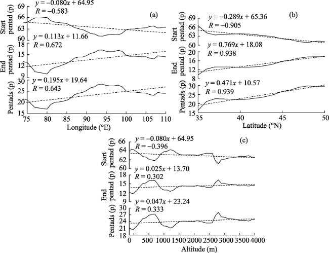
Figure 5 Mean change trends in the start (a) and end pentad (b) as well as pentads of cold period (c) at different longitudes, latitudes, and altitude ranks over Chinese oases
As latitude increases, the start pentad is advanced, the end pentad is postponed, and the pentads of cold period are extended, with change tendency rates of -0.289 p/1°N, 0.769 p/1°N and 0.471 p/1°N (α≥0.001), respectively. In latitudes between 47°N and 50°N, the start pentad reaches a minimum, while the end pentad and pentads of cold period reach maximum values, followed by 36°-39°N. Because the entire area of the northern Xinjiang oasis in the study area is distributed in northern latitudes between 47°N and 50°N, and the Qaidam Basin and southern Xinjiang oases are distributed in northern latitudes between 36°N and 39°N, the results latitude increases, the start pentad of the northern Xinjiang oasis is the earliest, the end pentad is the latest, and the pentads of cold period is the longest. The Qaidam Basin and southern Xinjiang oases are ranked in second place, confirming that latitude is also an important factor affecting cold period of the northern Xinjiang oasis.
As altitude increases, the start pentad is advanced, the end pentad is postponed, and the pentads of cold period is extended, with change tendency rates of -0.08 p/100m, 0.025 p/100m, and 0.047 p/100m (α≥0.001), respectively. In high-altitude areas (2600-3200 m asl), the start pentad reaches a minimum, and the end pentad and pentads of cold period reach maximum values, while lower-altitude areas (below 1000 m asl) are ranked second. As altitudes 2600-3200 m asl encompass the Qaidam Basin oasis and an altitude of 1000 m asl encompasses the northern Xinjiang oasis, it is clear that as this factor increases, the start pentad for the Qaidam Basin oasis is the earliest, the end pentad is the latest, and the pentads of cold period are the longest. The northern Xinjiang oasis ranks second, this illustrates that altitude is an important factor affecting the cold period in the Qaidam Basin oasis.

3.7 Responses to regional climate warming

In order to investigate the relationship between average monthly temperature and the start and end pentad as well as pentads of cold period in Chinese oases, the average temperatures for March and for November and for the period between November and March in the subsequent year, and the annual mean temperature recorded at each station in the study area, were all collected for analysis (Figure 6). Previously, trends in average temperature changes for March and for November, and for the period between November and March of the subsequent year, showed that average temperatures in these time slices conform to a warming trend, with correlation coefficients of 0.442, 0.451, and 0.617 (α≥0.001), respectively. These results show that the start pentad is mostly affected by November average temperature; thus, if the average temperature in November is higher, the beginning of cold period will be later. This result is supported by a correlation coefficient as high as 0.927 (α≥0.001). Results also show that the end pentad is mainly affected by March average temperature; thus, if the average temperature in March is higher, the end of cold period will be earlier. This result is supported by a correlation coefficient as high as -0.825 (α≥0.001). Finally, results show that the pentads of the cold period are mainly affected by average temperature during the period November to March of the subsequent year; thus, if the average temperature during this period is higher, then the cold period will be shorter. This result is supported by a correlation coefficient as high as -0.49 (α≥0.001).
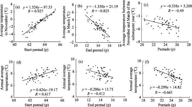
Figure 6 Relationship between trend magnitudes of the start (a), (d), end (b), (e), and pentads of cold period(c), (f) and average temperature in Chinese oases
In terms of the correlation coefficient of annual average temperature and the start and end pentad as well as pentads of cold period, when annual average temperature is higher, correlation coefficients are 0.617, -0.412, and -0.665 (α≥0.001), respectively. These results indicate that the start and end pentad as well as pentads of cold period respond very clearly to regional warming, while at the same time the correlation coefficient of the start pentad is higher than that of the end pentad. This indicates that the postponement response of the start pentad of the cold period to regional warming is more significant than advancement of the end pentad.
In order to further analyze the effects of regional warming on the start and end pentad as well as pentads of cold period, we conducted mutation tests for annual average temperature in northwest China using the Mann-Kendall test to show that there was an obvious mutation in 1987. Thus, we calculated average values for the start and end pentad as well as pentads of cold period before, and after 1987 (Table 4). Results show that, subsequent to 1987, the start pentad mutation has been postponed by 0.9 pentad, while the end pentad has advanced by 0.8 pentad, and the cold period has been shortened by 1.8 pentads. This indicates that regional warming has had different effects on the start and end pentad as well as pentads of cold period, and that its influence of the start pentad has been greater than on the end pentad.
Table 4 Mean values of the start and end pentad as well as pentads of cold period between 1960 and 1986, and between 1988 and 2014 in Chinese oases
Start pentad (p) End pentad (p) Pentads (p)
Before abrupt change 62.7 14.6 24.8
After abrupt change 63.6 13.8 23
Influence Postponed Advanced Shortened

4 Conclusions

(1) Over the last 55 years, the start pentad of cold period has been postponed, the end pentad has been advanced, and the pentads of cold period have been gradually shortened. Trend rates for these phenomena are 0.3 p/10a, -0.27 p/10a, and -0.58 p/10a, respectively. Mutation points for the start and end pentad as well as pentads of cold period were seen in 1990, 1998, and 1994, respectively, consistent with strong warming in China after 1990.
(2) Spatial differences in the start and end pentad as well as pentads of cold period are significant. The cold period in the Qaidam Basin oasis starts earliest, ends latest, and has the longest cold period, while the northern Xinjiang oasis is placed second. The cold period in the southern Xinjiang oasis starts latest, ends earliest, and has the shortest cold period. The rate of change in the cold period in the Qaidam Basin oasis is most obvious, however, suggesting that this has the most sensitive responses to global climate change.
(3) The TPI, APVAI, and CDE are the main factors affecting the cold period in the study area, while the SASM exerts the greatest influence on the Qaidam Basin oasis. Wavelet analysis shows that the start pentad and pentads of cold period are closely related to atmospheric circulation and El Nino events, whereas the end pentad of cold period is closely related to solar activity.
(4) As longitude increases, the start and end pentad as well as pentads of cold period exhibit change rates of -0.08 p/1°E, 0.113 p/1°E, and 0.195 p/1°E, respectively, while as latitude increases, these rates are -0.289 p/1°N, 0.769 p/1°N, and 0.471 p/1°N, respectively. As altitude increases, the change rates are -0.08 p/100m, 0.025 p/100m, and 0.047 p/100m, respectively.
(5) Average temperature in March, November, and the period between November and March of the subsequent year exert the greatest effects on the start and end pentad as well as pentads of cold period, respectively. The start and end pentad as well as pentads of cold period have shown good responses to regional warming, but there have been different effects on all three. Postponement of the start pentad as a regional warming response is more significant than advancement of the end pentad.

The authors have declared that no competing interests exist.

1
Alexander L V, Zhang X, Peterson T C et al., 2006. Global observed changes in daily climate extremes of temperature and precipitation. Journal of Geophysical Research: Atmospheres, 111(D5).

2
Changnon S A, Roger A P, David C et al., 2000. Human factors explain the increased losses from weather and climate extremes.Bulletin of the American Meteorological Society, 81: 437-442.

3
Chen Shaoyong, Wang Jinsong, Guo Junting et al., 2012. Evolution characteristics of the extreme high temperature event in Northwest China from 1961 to 2009. Journal of Natural Resources, 27(5): 832-844. (in Chinese)Using over years daily surface extreme air temperature and NCEP/NCAR data of 135 meteorological observation stations in Northwest China from 1961 to 2009,and adopting the methods of linear regression analysis,Mann-Kendall,moving t-examination,wavelet analysis,power spectrum and composite analysis,we analyzed the evolution characteristics of high temperature event in recent 49 years of Northwest China.The results show that spatial distribution of the extreme high temperature in Northwest China presents high value in the western and eastern parts,and low value in the central part.The main areas with extreme high temperature value are located in most part of Xinjiang,the western Hexi Corridor,the central and northern Gansu,southeastern Gansu,northern Ningxia and Shaanxi.The threshold values of the extreme high temperature in these areas are above 30 ℃;but in most part of southern Xinjiang and local areas of southern Shaanxi(Xi'an,Ankang),the threshold values are above 35 ℃,the max-value is 41.5 ℃in Turpan.The annual extreme high temperature is generally low in Qinghai Plateau,and high in Qaidam Basin(25-30 ℃),the other areas are between 15 ℃ and 20 ℃,the min-value is 14.4 ℃in Wudaoliang;the frequency of annual extreme high temperature has obviously increased at a rate of approximately 1.8 d/10 a.The high temperature days changed from less to more in the metaphase of the 1970s,especially the increasing rate is 5.4 d/10 a from the end of the 1980s,and there is an abrupt change phenomenon in 1994.The high temperature frequency has the remarkable periods of 3 to 5 years in recent 49 years.At present,it is still in the frequent phase of high temperature occurence;the annual extreme high temperature becomes more and more frequent in the majority areas of Northwest China.The main significant areas with SE-NW trend are distributed in two banded regions.One is from the Qinghai Plateau to West Tianshan,another from northern Shaanxi,southeastern Gansu-Gansu Corridor to Xinjiang's Altay.These areas tendency rate is above 2 d/10 a.The high value zone which reached above 5 d/10 a at west Hexi and the Xinjiang-Qinghai's southern border area.This shows that in the background of global warming,extreme high temperature event occurrence is more frequent in Northwest China;the values of the extreme high temperature are between 22.5 and 47.8 ℃,the maximum value appears in the Turpan Basin,and minimum value appears in Qinshui River of Qinghai Plateau,the high temperature that above 35 ℃appears in addition to the Yili Valley of most part of Xinjiang,Qaidam Basin,Hexi Corridor,central-northern of Gansu,southeastern Gansu,Ningxia,Shaanxi,and in southern Xinjiang,the high temperature is above 40 ℃;due to influence of altitude the extreme high temperature is obviously low in Qinghai Plateau,the values of most areas are between 25 ℃and 30 ℃,dropped from north to south.The high temperature may appear from April to October,and from June to August it accounted for 93% of the whole year;the frequency of high temperature increases obviously in June and July,and the rest of months is not obvious. There is an opposite geographic distribution between high temperature intensity and the extreme high temperature,namely the areas of the extreme high temperature is accompanied with lower high temperature intensity,so is the distribution of variance of the extreme high temperature.It shows that extreme high temperature interannual changes is smaller in high-heat area.There is most closely relation between annual extreme high temperature and annual high frequency,followed by July,June and August.Therefore,the stronger of high temperature,the more continued days.From the interdecadal change,the high temperature frequent occurrence phase is also the phase of the strongest high temperature,the global warming makes the extreme high temperature events increased and the intensity enhanced.The atmospheric circulation composite analysis indicated that it is beneficial to form the wide range and long-enduring high temperature weather in Northwest China when the Ural Mountain high ridge,the low trough of Balkhash Lake and the Mongolian high ridge are stable,and the atmosphere is at the quasi-barotropic state.

DOI

4
Ding Yihui, Geng Quanzhen, 1998. Atmosphere, ocean, human activity and global warming.Meteorological Monthly, 24(3): 12-17. (in Chinese)A review on the anthropogenic global warming,its associated carbon cycle and feedback processes in the atmosphere and ocean was given.

5
Du Jun, Lu Hongya, Jian Jun, 2013. Variations of extreme air temperature events over Tibet from 1961 to 2010.Acta Geographica Sinica, 68(9): 1269-1280. (in Chinese)Based on homogeneity-adjusted daily temperature (maximum, minimum and average) data of 18 stations, spatial and temporal changes of extreme temperature events over Tibet were analyzed for the period 1961-2010. The result shows that the number of frost days and ice days reduced significantly, with the most significant reduction in northern Tibet for ice days, but more extensively across the autonomous region for frost days. The length of growing season (GSL) presented a statistically significant increasing trend at a rate of 4.71 d/ 10a, especially in Lhasa and Zedang. The extra-maximum air temperature (TXx) and extra-minimum air temperature (TNn) generally increased. TXx significantly increased along the east section of the Yarlung Zangbo River and in Nagqu Prefecture, and decreased at the southern edge of Tibet, while TNn significantly increased across the region of Tibet, especially during 1981-2010 with a rate of 1.06oC/10a. Significant reduction at a rate of 9.38 d/10a (4.96 d/10a) occurred on cool nights (days), and significant increase at a rate of 10.99 d/ 10a (6.72 d/10 a) occurred for warm nights (TN90p) (days (TX90p)). There is a close correlation between the trends of most extreme temperature indices and altitude, i.e., positive correlations between altitude and TNn, negative correlations between altitude and TXx, TX90p, TN90p and GSL. In terms of decadal variations, TXx, TNn and other warm indices showed an increasing trend, while the cold indices and GSL decreased. It is also found that the abrupt change points of the TNn, warm (cool) nights and GSL were mainly observed before the mid-1990s, while frost days, ice days and warm (cool) days occurred in the early 2000s. In most cases, the linear trend magnitudes of extreme air temperature indices in Tibet were larger than those in the whole country, Tibetan Plateau and its surrounding areas (Qinghai Province, Hengduan Mountains), which show that the extreme air temperature indices response are more sensitive to the regional warming.

DOI

6
Duan A M, Wu G X, 2005. Role of the Tibetan Plateau thermal forcing in the summer climate patterns over subtropical Asia.Climate Dynamics, 24(11): 793-807.

7
Easterling D R, Horton B, 1997. Recent trends in maximum and minimum temperature trends for the globe.Science, 277: 364-367.

8
Feng Peizhi, Li Cuijin, Li Xiaoquan, 1985. Analysis of Main Meteorological Disasters in China. Beijing: China Meteorological Press, 110-117. (in Chinese)

9
Fu Dongxue, Sun Zhaobo, Li Zhongxian et al., 2011.Spatial and temporal features of China minimum temperature in winter half year during 1955–2006. Journal of the Meteorological Sciences, 31(3): 274–281. (in Chinese)Based on the daily minimum temperature data of 275 stations in China during 1955 2006,the spatial and temporal features and variation trends of the extreme minimum temperature are studied.Results show that the frequency of the extreme minimum temperature decrease all over China with the significantly decreased mutation taking place in 1983.The most significantly reduced trend locates in North China,and the middle-lower reaches of Yangtze River and its south regions,and the least significant one lies in the Hetao area.The reduced trend is weak in Sichuan Basin and Yunnan-Guizhou Plateau regions.The regional spatial differences of the extreme minimum temperature events are significant,and the abrupt change years of the extreme minimum temperature frequency are inconsistent in different regions,in such a way that there are obvious differences before and after the mutation.During the recent years,the extreme minimum temperature variations tend to be steady in different regions.

DOI

10
IPCC, 2007. Summary for Policymakers of Climate Change 2007: The Physical Science Basis. In: Contribution of Working Group I to the Fourth Assessment Report of the Intergovernmental Panel on Climate Change. Cambridge, UK: Cambridge University Press.Summary for policymakers. Climate change 2007: the physical science basis - Eldis

11
IPCC, 2013. Climate Change 2013: the physical science basis. Contribution of Working Group I to the Fifth Assessment Report of the Intergovernmental Panel on Climate Change. Cambridge & New York: Cambridge University Press.

12
Karl T R, Kukla G, Razuvayev V N et al., 1991.Global warming: Evidence for asymmetric diurnal temperature change. Geophysical Research Letters, 18: 2253–2256.Analyses of the year-month mean maximum and minimum surface thermometric record have now been updated and expanded to cover three large countries in the Northern Hemisphere (the contiguous United States, the Soviet Union, and the People's Republic of China). They indicate that most of the warming which has occurred in these regions over the past four decades can be attributed to an increase of mean minimum (mostly nighttime) temperatures. Mean maximum (mostly daytime) temperatures display little or no warming. In the USA and the USSR (no access to data in China) similar characteristics are also reflected in the changes of extreme seasonal temperatures, e.g., increase of extreme minimum temperatures and little or no change in extreme maximum temperatures. The continuation of increasing minimum temperatures and little overall change of the maximum leads to a decrease of the mean (and extreme) temperature range, an important measure of climate variability.The cause(s) of the asymmetric diurnal changes are uncertain, but there is some evidence to suggest that changes in cloud cover plays a direct role (where increases in cloudiness result in reduced maximum and higher minimum temperatures). Regardless of the exact cause(s), these results imply that either: (1) climate model projections considering the expected change in the diurnal temperature range with increased levels of the greenhouse gases are underestimating (overestimating) the rise of the daily minimum (maximum) relative to the maximum (minimum), or (2) the observed warming in a considerable portion of the Northern Hemisphere landmass is significantly affected by factors unrelated to an enhanced anthropogenically-induced greenhouse effect.

DOI

13
Li Baofu, Chen Yaning, Shi Xun, 2012. Why does the temperature rise faster in the arid region of China? Journal of Geophysical Research: Atmospheres, 117(D16115).During 1960-2010, the air temperature in the arid region of northwest China had a significant rising trend (P < 0.001), at a rate of 0.343 C/decade, higher than the average of China (0.25 C/decade) and that of the entire globe (0.13 C/decade) for the same period. Based on the analysis of the data from 74 meteorological stations in the region for 1960-2010, we found that among the four seasons the temperature change of winter has been playing the most important role in the yearly change in this region. We also found that the winter temperature in this region has a strong association with the Siberian High (correlation coefficient: R = -0.715) and the greenhouse gas emission (R = 0.51), and between the two the former is stronger. We thus suggest that the weakening of the Siberian High during the 1980s to 1990s on top of the steady increasing of the greenhouse emission is the main reason for the higher rate of the temperature rise in the arid region of the northwest China.

DOI

14
Li Lin, Chen Xiaoguang, Wang Zhenyu et al., 2010. Climate change and its regional differences over the Tibetan Plateau.Advances in Climate Change Research, 6(3): 181-186. (in Chinese)Using the meteorological observation data including temperature and precipitation at 66 stations over the Tibetan Plateau from 1961 to 2007, by means of the typical climate zoning, the spatio-temporal variations of climatic variables over the plateau in the recent 47 years were systematically studied, and the differences of climate change in different sub-regions were shown. The results indicate that the climate over the Tibetan Plateau overally showed a significant warming trend in the recent 47 years, the annual mean temperature rose at a rate of 0.37℃/10a; the warming was more remarkable in nighttime than in daytime, and in winter than in other seasons. The change from colder to warmer was the most significant in February, but the least in August, when climate showed a cooling trend in some areas. Climate warming at the edge of the plateau was more obvious than in the hinterland. The northern of Qinghai, especially the Qaidam Basin was a most sensitive area to climate change. Precipitation showed a rising trend at a tendency rate of 9.1 mm/10a; but regional differences were very apparent, the western of Sichuan, which lies in the southeast of Tibet, was the most significant in precipitation-increasing in the whole Tibetan Plateau; Precipitation in winter and spring (from December to May of the next year) in all areas increased with the climate warming; but the drought trend in the upstream of Yellow River was obvious after 1987.

15
Lin Xiang, Qian Weihong, 2003. Trend on the daily mean air temperature and its anomalous strength in China for the warm season in the last 40 years.Acta Geographica Sinica, 58(Suppl.): 21-30. (in Chinese)Trends on the daily mean air temperature and its anomalous strength in China for the warm season (May-September) in the last 40 years (1961-2000) were analyzed using observational 453-station datasets including daily temperature and daily precipitation. Calculation methods are standard deviation and Skewness. Results show that there were different spatial-temporal characteristics in the daily air temperature variability. In the last 40 years, a warming trend was commonly noted in China but the stronger warming was located in the area north of the Yellow River. For the time evolution, a transition time point was found in the late 1970s from a cooling trend to a warming trend but the stronger warming appeared since the late 1990s. The amplifying daily temperature anomaly indicated a trend of climate variability in many places of China. The relationships between daily air temperature and rainfall events were also discussed particularly in the coastal regions.

16
Liu Dexiang, Dong Anxiang, Deng Zhenyong, 2005. Impact of climate warming on agriculture in Northwest China.Journal of Natural Resources, 20(1): 119-125. (in Chinese)Using data of 171 observations from 1961 to 2003 in Northwest China,mean monthly temperature,highest temperature,lowest temperature,accumulated temperature &ge;0℃,&ge;10℃,and negative accumulated temperature &lt;0℃ were collected to analyze response of climate warming on heat resource and impact of climate warming on agricultural production.The results showed that mean monthly temperature,highest temperature,lowest temperature and accumulated temper-ature &ge;0℃ and &ge;10℃ of 1987~2003 were significantly higher than that of 1961~1986,especially the lowest temperature increment markedly increasing and the increment of winter greater than that of summer,the lowest temperature rising played a main role on climate war-ming over Northwest China.The negative accumulated temperature &lt;0℃ reduced obviously.As the trends of climate change appeared warming since the late 1980s in Northwest China,thermal resource increased,planting areas of heliophilous crops expanded,the planting area of north boundary of crops would extend northward which is favorable for animals to overwinter and spend spring.The negative impacts of climate warming on agriculture is greater than the positive.

DOI

17
Liu Qinge, Wu Xiaoqing, Chen Xiaohong et al., 2015.Temporal and spatial variation characteristics of extreme temperature in the Pearl River Basin during 1960–2012. Journal of Natural Resources, 30(8): 1356–1366. (in Chinese)Extreme and high frequency weather events caused by the global warming, have brought huge influences to human activities as well as ecological environment. Within this context, analyzing extreme temperature event that is one of the extreme weather events is of paramount importance for human activities. The Pearl River Basin, one of the richest basins in China, locates in the subtropical monsoon region where the climate characteristics are quite complicated. Meanwhile, as global climate changes, the extreme temperature event in the basin should bring some new change which, however, is still unknown. Therefore, the purpose of this paper is to analyze the temporal and spatial variation characteristics of the extreme temperature event in the Pearl River Basin. In this paper, 16 indexes related to extreme temperature were selected. The data about these indexes at 43 weather stations (1960-2012) have been collected and processed to guarantee the rationality of the results. Linear regression, Mann-Kendall as well as wavelet analysis were used to analyze the temporal variation characteristics of the extreme temperature. Kriging, one of the spatial interpolation technologies, was also used to analyze the spatial variation characteristics. The results show that: 1) for the temporal trend, the indexes of ID0, TXn, TX10p and GSL showed non-significant trend whereas the others showed significant increasing or decreasing trend (<0.05). 2) Spatially, the indexes of TN10p, CSDI, DTR and TX10p showed an overall downward trend whereas the others showed an overall upward trend in the basin, with non-significant spatial variations. 3) The mutation analysis disclosed that except the indexes of ID0, TX10p and GSL, the other indexes all passed significance inspection and most of the abrupt change points happened in 1980s but that of TR20 and SU25 occurred in 1994 and 2001 respectively. 4) The wavelet analysis discovered that there existed multiple periodic oscillations for the values of most indexes and the primary periods were 2-4 years. SCSMI and ENSO are the main factors caused the extreme temperature event in the study area. This study has the potential to provide valuable references for agricultural protection, water resources management, drought disaster control, and other crucial applications in the Pearl River Basin.

18
Liu Xin, Li Weiping, Wu Guoxiong, 2002. Interannual variation of the diabatic heating over the Tibetan Plateau and the Northern Hemispheric circulation in summer.Journal of the Meteorological Sciences, 60: 267-277. (in Chinese)The diabatic heating rates and circulation data from NCEP/NCAR reanalysis (1958-1997) are employed to study the interannual variation of the summertime diabatic heating over the Tibetan Plateau (TP) and the Northern Hemispheric circulation, and the relationship between them by using correlation and composite methods. It is shown that when the summertime diabatic heating over the TP is stronger than normal, the rising motion as well as low level convergence and upper level divergence of the air over the TP and the neighboring areas is intensified. This will induce the stronger than normal sucking in of the low level warm and moist air towards the TP, and more intense pushing out of upper level air as well. The atmospheric circulation over the TP and the Asian monsoon area is therefore affected. Besides, a Rossby wave train is forced by the diabatic heating over the TP and by the induced divergence field along the eastern coast of Asia, propagating northeastward and affecting the circulation in the Northern Hemisphere.

DOI

19
Manton M J, Della-Marta P M, Haylock M R et al., 2001. Trends in extreme daily rainfall and temperature in Southeast Asia and the South Pacific: 1996-1998.International Journal of Climatology, 21(3): 269-284.Trends in extreme daily temperature and rainfall have been analysed from 1961 to 1998 for Southeast Asia and the South Pacific. This 38-year period was chosen to optimize data availability across the region. Using high-quality data from 91 stations in 15 countries, significant increases were detected in the annual number of hot days and warm nights, with significant decreases in the annual number of cool days and cold nights. These trends in extreme temperatures showed considerable consistency across the region. Extreme rainfall trends were generally less spatially coherent than were those for extreme temperature. The number of rain days (with at least 2 mm of rain) has decreased significantly throughout Southeast Asia and the western and central South Pacific, but increased in the north of French Polynesia, in Fiji, and at some stations in Australia. The proportion of annual rainfall from extreme events has increased at a majority of stations. The frequency of extreme rainfall events has declined at most stations (but not significantly), although significant increases were detected in French Polynesia. Trends in the average intensity of the wettest rainfall events each year were generally weak and not significant.

DOI

20
Milanovic M, Gocic M, Trajkovic S, 2015. Analysis of extreme climatic indices in the area of Nis and Belgrade for the period between 1974 and 2003.Agriculture and Agricultural Science Procedia, 4: 408-415.Extreme climatic events are the most important elements of climate changes, which directly affect the nature and society. In the recent years, the plethora of extreme climatic indices have been developed for the different parameters, in order to analyze and monitor the extreme climate changes. This paper presents the analysis of maximum and minimum air temperatures (T max , T min ) and precipitation using the eight extreme climatic indices in the city of Nis and Belgrade (Serbia) for the period 1974-2003. The selected indices are: frost days (FD), summer days (SU), ice days (ID), max TX (TXx), max TN (TNx), max 1-day precipitation (Rx1day), consecutive dry days (CDD) and consecutive wet days (CWD). The results show that there are no significant changes in the FD and ID indices, and there are also no changes in the indices CDD and CWD in Nis. The SU, Rx1day, TXx and TNx were increased in each of the observed cities. CDD and CWD were slight decreased in Belgrade.

DOI

21
Pan Baotian, Li Jijun, 1996. The Qinghai-Tibet Plateau: A driver and amplifier of the global climatic change.Journal of Lanzhou University (Natural Science), 32(1): 108-115. (in Chinese)A good corresponding relationship between the occurrances of important climatic changes and the intense tectonic movements of the Qinghai-Tibetan Plateau in the Cenozoic implies that they are closely linked. It is possible that the uplift of the Qinghai-Tibetan Plateau resulted in great climatic changes and in the formation and intensity of the modern East Asia monsoon. The grand Qinghai-Tibetan Plateau had two influences on atmospheric system, the function heating the air and the function of obstructing air flow. They formed Mongolian High Pressure in winter and Indian Low Pressure in summer, thus giving rise to the appearance of East Asia monsoon. The higher the Qinghai-Tibetan Plateau, the more conspicuous its functions on air, the more intence the Mongolian High Pressure and Indian Low Pressure and East Asia monsoon. Therefore, the formation and intensity of East Asia monsoon were the results of the uplift of Qinghai-Tibetan Plateau. The greater intensity of East Asia Monsoon and the dynamic function of the plateau also reinforced the Rossby Wave. resulting in the continuous expansion of polar cool moving soutbward in glacial age and in greater climatic fluctuation amplitude. The aggravation of chemical weathering resulting from the tectonic uplift of Qinghai-Tibean Plateau and the monsoon formation reduced the contents of CO2 in the atmosphere, so the global climate became cool. Therefore, the uplift of the Qinghai-Tibetan Plateau was one of the important factors controlling the climatic changes in the Cenozoic.

22
Plummer N, 1999. Changes in climate extremes over the Australian region and New Zealand during the twentieth century.Climatic Change, 42: 183-202.Analyses of high quality data show that there have been some interesting recent changes in the incidence of some climate extremes in the Australian region and New Zealand. For the Australia region:

DOI

23
Ren Fumin, Zhai Panmao, 1998. Study on changes of China’s extreme temperatures during 1951-1990.Scientia Atmospherica Sinica, 22(2): 217-227. (in Chinese)Based on China′s extreme temperature data during 1951~1990, after minimizing the possible biases caused by station moving and urban heat island effect, and performing quality control procedure, this paper mainly studies the spatial and temporal distribution of variability and trends for extreme temperatures The results show that the variability of extreme minimum temperatures in most part of China in spring and autumn is greater than those in other seasons, especially in the northern China Variability of extreme minimum temperatures in summer, however, is the smallest in most part of China There exist clear temporal (seasonal) differences in trends of China′s extreme temperatures The increasing trends of China′s extreme minimum temperatures in winter and autumn are both significant at the statistical t -test level of 99% and 97% respectively, while decreasing trend of all-China mean extreme maximum temperature is significant only in autumn at the statistical t -test level of 90% There also exist obvious regional differences in trends of extreme temperature in China Increasing trends of extreme minimum temperatures are obvious in all seasons in Northeast China, northern North China, central-eastern Inner Mongolia and the Sichuan-Tibet adjoining region, while decreasing trends of extreme maximum temperatures are obvious in the Yangtze River valley in autumn and winter, and in the lower reaches of the Yellow River in spring and summer

24
Sheikh M M, Manzoor N, Ashraf J et al., 2015. Trends in extreme daily rainfall and temperature indices over South Asia.International Journal of Climatology, 35(7): 1625-1637.Over the last few decades, weather and climate extremes have become a major focus of researchers, the media and general public due to their damaging effects on human society and infrastructure. Trends in indices of climate extremes are studied for the South Asian region using high‐quality records of daily temperature and precipitation observations. Data records from 210 (265) temperature (precipitation) observation stations are analysed over the period 1971–2000 (1961–2000). Spatial maps of station trends, time series of regional averages and frequency distribution analysis form the basis of this study. Due to the highly diverse geography of the South Asian region, the results are also described for some specific regions, such as the island of Sri Lanka; the tropical region (excluding Sri Lanka); the Greater Himalayas above 35°N, the Eastern Himalayas (Nepal) and the Thar Desert. Generally, changes in the frequency of temperature extremes over South Asia are what one would expect in a warming world; warm extremes have become more common and cold extremes less common. The warming influence is greater in the Eastern Himalayas compared with that in the Greater Himalayas. The Thar Desert also shows enhanced warming, but increases are mostly less than in the Eastern Himalayas. Changes in the indices of extreme precipitation are more mixed than those of temperature, with spatially coherent changes evident only at relatively small scales. Nevertheless, most extreme precipitation indices show increases in the South Asia average, consistent with globally averaged results. The indices trends are further studied in the context of Atmospheric Brown Clouds (ABCs) over the region. Countries falling within the ABC hotspot namely Indo‐Gangetic Plain (IGP) have shown a different behaviour on the trends of extreme indices compared with the parts outside this hotspot. IGP has increased temperature and decreased rainfall and tally closely with the actual trends.

DOI

25
Solomon S, Qin D, Manning M et al., 2007. Contribution of Working Group I to the Fourth Assessment Report of the Intergovernmental Panel on Climate Change. Cambridge, United Kingdom and New York: Cambridge University Press.Mitigation is an all-embracing category used in pragmatics to label the wide set of strategies by which speakers attenuate one or more aspects of their speech. The notion and the term were introduced by Fraser (1980) to refer to the linguistic devices by which speakers try to protect themselves against various kinds of interactional risks. So far mitigation has been a subtopic of the wide field of research in politeness and its dominating metaphor of face. However, in mitigating processes, there seems to be another motivational factor, more basic than politeness, i.e., reducing responsibility. As a concept that captures the rhetorical, indexical quality of our communicative behaviors, mitigation foregrounds the multidimensional character of discursive choices.

DOI

26
Wang Qiong, Zhang Mingjun, Wang Shengjie et al., 2013. Extreme temperature events in Yangtze River Basin during 1962-2011. Acta Geographica Sinica, 68(5): 611-625. (in Chinese)Based on daily maximum and minimum temperature observed by the China Meteorological Administration at 115 meteorological stations in the Yangtze River Basin from 1962 to 2011,the methods of linear regression,factor analysis and correlation analysis are employed to analyze the temporal variability and spatial distribution of climate extremes.Sixteen indices of extreme temperature are studied.The results are as follows:(1) The occurrence of cold days,cold nights,ice days,frost days and cold spell duration days has significantly decreased by-0.84,-2.78,-0.48,-3.29 and-0.67 days/decade,respectively,while the occurrence of warm days,warm nights,summer days,tropical nights,warm spell duration days and growing season length shows statistically significant increasing trends at rates of 2.24,2.86,2.93,1.80,0.83 and 2.30 days/decade,respectively.The tendency rate of monthly minimum value of daily maximum(minimum) temperature,monthly maximum value of daily maximum(minimum) and diurnal temperature range is 0.33,0.47,0.16,0.19 and-0.07 o C/decade,respectively.(2) The magnitudes of changes in cold indices(cold nights,monthly minimum value of daily maximum,monthly minimum value of daily minimum) are obviously greater than those of warm indices(warm nights,monthly maximum value of daily maximum and monthly maximum value of daily minimum).The change ranges of night indices(warm nights and cold nights) are larger than those of day indices(warm days and cold days),indicating that the changes of day and night temperature are asymmetrical.(3) Spatially,the regionally averaged values of cold indices in the upper reaches of the Yangtze River Basin are larger than in the middle and lower reaches.However,the regionally averaged values of warm indices and growing seasons except warm spell duration indicator are larger in the middle and lower reaches than in the upper reaches.(4) The extreme temperature indices are highly correlated with each other except diurnal temperature range.

DOI

27
Wang Wensheng, Ding Jing, Xiang Hongliang, 2002. Multiple time scales analysis of hydrological time series with wavelet transform.Journal of Sichuan University (Engineering Science Edition), 34(6): 15-17. (in Chinese)Based on Marr wavelet and Morlet wavelet transform, the multiple time scales and jump features of 100 years annual average runoff at Yichang station of Yangtse River have been analyzed. The studied results have shown that the above characteristics exist unevenly in the discussed time domain and it is very easy to search the jump point of the time series. The wavelet transform has the advantage of probing the multi time scale of hydrology and water resources time series.

DOI

28
Wei Fengying, 1999. Modern Climatic Statistical Diagnosis and Forecasting Technology. Beijing: China Meteorological Press. (in Chinese)

29
Yang Faxiang, Fu Qiang, Mu Guijin et al., 2007. Study on regionalization of oases in China.Arid Zone Research, 24(5): 569-573. (in Chinese)

30
Yang Jinhu, Jiang Zhihong, Wei Feng et al., 2006. Variability of Extreme high temperature and low temperature and their response to regional warming in Northwest China in recent 45 years.Arid Land Geography, 29(5): 625-631. (in Chinese)Most research have show that extreme climate event(drought,flood,typhoon, high temperature,low temperature and so on)bring about heavy economy loss,so in recent years extreme climate event have arouse the public wide concern,extreme temperature as a kind of extreme climate event have been researched by most specialist in recent years,but detailed study of extreme temperature of northwest china is few,so we count up frequency of annual extreme high temperature(frequency of exceed to 32 temperature),frequency of annual extreme low temperature(frequency of lower than-15 temperature),annual extreme high temperature intensity(average of annual maximum three exceed to 32 temperature),annual extreme low temperature intensity(average of annual maximum three lower than-15 temperature),onset and upset date of annual extreme high temperature and low temperature from 1960-2004 years 129 stations day-to-day maximum and minimum temperature data of northwest china and analyze spatial distribution feature and long-term change tendency of extreme high and low temperature frequency,long-term change tendency of extreme high and low temperature intensity and change feature of onset and upset date of annual extreme high temperature and low temperature.The result show that in recent 45 years increasing trend of annual extreme high temperature frequency is very clear,and decreasing trend of annual extreme low temperature frequency is more remarkable in northwest china;in recent 45 years annual extreme high temperature intensity is strengthen gradually,and annual extreme low temperature intensity is weaken gradually in northwest china,but the weak degree of annual extreme low temperature intensity is clear than strength degree of annual extreme high temperature intensity;in most areas onset date of annual extreme high temperature is advance gradually,and its upset date is postpone gradually in recent 45 years,on the contrary,onset date of annual extreme low temperature is postpone gradually,and its upset date is advance gradually;in recent 45 years warming tendency is very clear in northwest china,decreasing tendency of annual extreme low temperature frequency response to regional warming of northwest china is more remarkable than increasing tendency of annual extreme high temperature frequency,rising tendency of extreme low temperature intensity is more feeble than rising tendency of extreme high temperature intensity to response to regional warming of northwest china,however increasing tendency of annual extreme high temperature frequency is correspond to rising tendency of extreme high temperature intensity to response to regional warming of northwest china.

DOI

31
Yao Junqiang, Liu Zhihui, Yang Qing et al., 2014. Temperature variability and its possible causes in the typical basins of the arid Central Asia in recent 130 years.Acta Geographica Sinica, 69(3): 291-302. (in Chinese)Basin-scale is of the special significance to the climate change research in arid areas. In this study, data from five typical basins of the arid Central Asia are analyzed to investigate changes in annual temperature during the period of 1881-2011. The nonparametric Mann- Kendall test, wavelet analysis and the correlation analysis are used to identify trend, multiple time scale feature and their possible causes in the annual temperature. The results show that the average annual temperature had an increasing trend in the main basins (except Amu Darya Basin) of the arid Central Asia in the past 130 years. The rising rate is consistent with that of the northern hemisphere, much higher than that of the global average and surrounding region, suggesting that the arid Central Asia is more sensitive to climate change than other regions. Abrupt change point in annual temperature occurred around the year of 1986, and showed significant multi-time scale periodic oscillation, which is mainly due to the physical external force and internal climate-control system. The Central Asian vortexes' activity has a significant effect on annual temperature of the typical basins, followed by the northern annual mode cycle variation and the Tibetan Plateau, while the greenhouse effect caused by CO<sub>2</sub> gas emissions in the arid Central Asia can not be ignored. Temperatures show an aperiodic cycle which is related to the BC, PDO and TBO, and we can confirm that temperature in the arid Central Asia is closely related to the atmospheric circulation, sea surface temperature and solar activity.

DOI

32
Yao Tandong, Liu Xiaodong, Wang Ninglian, 2000. The issue of climate change in the Qinghai-Tibet Plateau area,Chinese Science Bulletin, 45(1): 98-106. (in Chinese)

33
Zhai Panmao, Sun Anjian, Ren Fumin et al., 1999. Changes of climate extremes in China.Climatic Change, 42(1): 203-218.Changes in China's temperature and precipitation extremes have been studied by using observational data after 1950. The results reveal that mean minimum temperature has increased significantly in China during the past 40 years, especially in the winter in northern China. Meanwhile, nation-wide cold wave activity has weakened and the frequency of cold days in northern China has been reduced significantly. Mean maximum temperatures display no statistically significant trend for China as a whole. However, decreasing summer mean maximum temperatures are obvious in eastern China, where the number of hot days has been reduced. Seasonal 1-day extreme maximum temperatures mainly reflect decreasing trends, while seasonal 1-day extreme minimum temperatures are increasing. A statistically significant reduction of much above normal rain days in China has been detected. Contrarily, an increasing trend was detected in much above normal of precipitation intensity (precipitation/number of precipitation days) during the past 45 years.

DOI

Outlines

/